Abstract
Under the influence of climate change and human activities, the southern boundary of the permafrost region in Northeast China, which is located at the southern edge of the permafrost area of Eurasia, has moved north, the surface temperature has increased, and the thickness of the frozen layer has decreased. At present, there is a lack of classification standards or a map of the thermal state of permafrost that can reflect the dynamic change characteristics of permafrost in Northeast China. A vegetation impact factor consisting of normalized difference vegetation index and forest canopy closure was introduced into MODIS LST products, in order to improve the applicability of products in Northeast China. Based on the improved MODIS LST data, this study analyzed the distribution and change of the mean annual surface temperature and the surface frost number (SFnc) from 2003 to 2019. SFnc was used as the standard to classify the thermal state of permafrost, and a map of the thermal state distribution and changes of permafrost in Northeast China, with a spatial resolution of 1 km, was produced. Compared with the observation data of meteorological stations and field monitoring data, the reliability of classification results was nearly 95%. The map showed that there was no area of extremely stable permafrost (SFnc ≥ 0.667), the area of stable permafrost (0.55 ≤ SFnc < 0.667) changed from 14.9 × 10⁴ km2 to 6.5 × 10⁴ km2, the SFnc reduced from 0.564 to 0.557, the area of semi-stable permafrost (0.51 < SFnc < 0.55) changed from 17.68 × 10⁴ km2 to 17.77 × 10⁴ km2, the SFNc reduced from 0.529 to 0.528, and the area of transitional or unstable permafrost (0.49 ≤ SFnc ≤ 0.51) changed from 8.67 × 10⁴ km2 to 9.56 × 10⁴ km2. The thermal state of permafrost decreased and the distribution of stable permafrost shrank, due to continuous rising air temperature. The overall change characteristics of the thermal state distribution of permafrost were that the southern boundary of the permafrost region moved northward, the regional permafrost thermal state decreased, and there was an increased region of semi-stable, transitional or unstable permafrost from the frozen soil thawed at the edge of the permafrost region with higher stability. The permafrost region in Northeast China has lush vegetation, and the continuous degradation of permafrost will change the vegetation growth environment and affect the global carbon cycle process. This work will provide important data support for climate change feedback, natural disaster process research, and an early warning and prevention of terrestrial ecosystem response in the permafrost region of Eurasia.
1. Introduction
Permafrost is a soil layer with a temperature below 0 °C for more than two years at a certain depth under the surface [1]. It is a geological body developed through the exchange of material and energy between the earth and atmosphere under the background of geological history and climate change, and the comprehensive influence of regional geographical environment, geological structure, lithology, hydrology and ground cover characteristics [1]. Global permafrost is mainly distributed in high latitude regions such as northern Eurasia, northern North America, high mountains and plateaus at middle and low latitudes, and the land on the outer edge of the Antarctic ice sheet and the seabed of the polar continental shelf [2,3]. Permafrost is extremely sensitive to climate change, and surface temperature is the key factor affecting the occurrence of permafrost [4]. In recent years, permafrost has been degraded by global warming, which has mainly manifested in the ground temperature rising, the distribution area shrinking, the thickness thinning, the active layer thickening, and thermokarst lakes and ponds increasing [5]. These changes are related to the ecology, hydrology [6,7,8], and even climate, in the region, and have attracted attention [9]. During the freezing and thawing process of the soil layer, changes in the thermal state lead to phase state changes in the water, accompanied by a large amount of latent heat exchange [9,10,11]. On an interannual scale, when the absorbed heat is greater than the released heat, there is a surplus of heat which will increase the temperature of the soil layer, causing the thickness of the active layer to increase, or the thawing of the frozen soil [9,12,13,14]. The surface is an important interface between the land and the atmosphere, whose thermal state comprehensively reflects the energy exchange status of the atmosphere, vegetation and soil. The change of the surface thermal state is also an important manifestation of the heat storage and release of the soil layer, which can reflect the evolution, development, degradation and disappearance of permafrost. It is also the upper boundary condition of the permafrost distribution model and some land surface process models. In previous studies, the mean annual surface temperature (MAST) and surface frost number (SFn) have often been used as the upper boundary conditions for the development of permafrost [15,16], which directly or indirectly reflect the response of the terrestrial system to the climate.
The Sixth Assessment Report of the IPCC in 2021 pointed out that the global average surface temperature increased by about 1 °C since 1850–1900 [17]. The warming effect is further amplified in high-latitude and high-altitude areas, resulting in the permafrost thawing in these areas [18,19,20,21]. The Blue Book on China’s Climate Change in 2020 [22], points out that China’s surface temperature rising rate was 0.24 °C/10a from 1951 to 2019, higher than the global average in the same period. The temperature increase rate in the northern region was significantly higher than in the southern region. A large amount of CH4 and CO2 isothermal greenhouse gas is released during permafrost thawing, which affects the global carbon cycle and exacerbates global warming [19,20,21,22], and changes the ecological, hydrological and geomorphic landscape pattern in the region, which has a significant impact on regional environment, food and water resources security [20,23,24,25,26,27,28]. In addition, permafrost thawing also leads to local land subsidence, slope instability and other environmental geological problems and secondary disasters, which seriously threaten the stability and durability of infrastructure such as roads and railways. The Northeast China permafrost region is located at the southern edge of the Eurasian permafrost region, and is the second largest permafrost distribution area and the only high-latitude permafrost region in China. The frozen soil has a high temperature, thin thickness, unstable thermal state, and is vulnerable to interference from external environment, climate and human factors [29,30,31,32,33]. Since 1980, the fluctuation of air temperature in Northeast China has increased, and the growth rate has been higher than the global average [34,35,36]. The more extreme warming occurred in the northern region [37], especially in the northern Greater Khingan Mountains (GKM) and Lesser Khingan Mountains (LKM) [38]. Under the comprehensive influence of regional environmental geological conditions, climate warming and human activities, the most developed permafrost on the northwest slope of GKM has degraded, and the thawing area has significantly expanded [39,40]. The ground temperature at 13 m depth in Yitulihe increased by 0.2 and 0.4 °C, respectively, from 1984 to 1997, and from 1997 to 2010 [41,42]; and at 10 m depth, in Mohe, it increased from −3.7 °C to −1.5 °C from 1975 to 1978 [43,44,45]. In the past 50 years, the air temperature in Northeast China has generally increased by 0.9~2.2 °C, which has caused the south boundary of permafrost to move significantly northward, and the area of permafrost has decreased by 35~37% compared with the 1970s. If the air temperature increases by 1~1.5 °C in the next 40~50 years, the southern boundary of permafrost will move further northward, and the area of permafrost may reduce by 35% [46].
Permafrost mapping methods can be divided into three categories, including statistical learning, empirical models and physical models. With the technological progress and product accumulation of remote sensing, high-quality input data has improved the methods and models of permafrost mapping, which has promoted its rapid development. Although the empirical model is based on mathematical statistics as per statistical learning and physical models, it is more important to build on the basis of long-term observation and practice, and, therefore, the empirical model is a summary of experience in understanding the spatial distribution of permafrost. In the application process, the empirical model has a fixed structure and high computational efficiency. Combined with ground observations, it can play a very important role in the verification of simulation results. The typical empirical models are widely used in permafrost mapping in China, mainly the: elevation model, equivalent elevation model, frozen number model, Stefan formula, TTOP model and GIPL-1.0 model. From the first Northern Hemisphere permafrost extent map compiled by Brown et al. [47], to the first high-resolution (30 arc-second) map of the global permafrost zonation simulated by Gruber [48], permafrost mapping has achieved important research results in observational data and permafrost models. Similar to the development process of international permafrost mapping, there has also been a continuous development of permafrost mapping processes in China. In recent years, the development and application of geographic information systems, remote sensing technology, permafrost physical and empirical models, and the continuous establishment of ground observation networks, have overcome the shortcomings of spatial representative error of single point observation of ground meteorological stations [49,50,51,52], providing more data support for research. Integrating comprehensive modeling with multi-source observation can also provide more spatial details for the analysis of permafrost distribution and surface thermal state patterning [48,53,54]. The SFn model [55,56,57], using the surface thermal state as the upper boundary condition, is widely used to reflect the distribution of permafrost. This model is an empirical model, and was proposed by Nelson and Outcalt [58] on the basis of correcting the air frost number (Fn) model [59]. The plane distribution areas of the continuous and discontinuous permafrost and seasonal frozen soil are divided according to the Fn. Li [6] and Wang [60] used the frost number model to simulate the permafrost distribution on the Qinghai–Tibet Plateau (QTP), but local factors such as altitude and terrain were not considered in the model. Nan et al. [61] added influence factors on the basis of the surface frost number model, and simulated permafrost distribution on the QTP. Ran et al. [62,63] used MODIS Aqua/Terra LST products to estimate the MAST and SFn from 2003 to 2010, and the 0 °C isotherm of MAST and 0.5 contour of SFn agreed well with the identified southern/lower limits of permafrost in China. Combined with ground and remote sensing observation data, and defined with remote sensing MAST and SFn standards for classifying permafrost stability and mapped permafrost stability, the latest important research on permafrost mapping on the QTP has resulted. LV [64] first applied the SFn model to Northeast China. The model considered climatic factors and snow depth data. By comparing with permafrost zoning maps of different periods, the applicability of the model to the northeast permafrost zoning was discussed. Zhang et al. [65,66,67] analyzed the main factors affecting the distribution and change of permafrost in Northeast China. Using Fn and SFn models based on meteorological stations data and the China meteorological forcing dataset to divide the permafrost zone, the studies showed that the permafrost area decreased from 4.8 × 10⁵ km2 to 3.1 × 10⁵ km2, the southern boundary of permafrost moved northward by 0.1–1.1°, and the average elevation increased by 160.5 m, from the 1950s to the 2010s.
Influenced by the permafrost classification systems of the former Soviet Union and North America [68], the continuous classification system is still used to divide permafrost in permafrost research in Northeast China. This classification standard cannot provide more details on permafrost at the spatial scale. Converse to the permafrost distribution characteristics of the QTP, the permafrost region in Northeast China has dense surface vegetation and covering vegetation (moss, grass or forest) [69,70], which have significant effects on the hydrothermal process, spatial distribution and permafrost temperature [71,72,73]. The applicability of high-altitude permafrost classification standards [74,75] in Northeast China remains to be verified. Large-scale ground observation historical data are few and discontinuous, and the remote sensing surface temperature as a high-quality data source is rarely applicable in the process of permafrost mapping in Northeast China. With the development of environmental protection and infrastructure construction, classification standards for the thermal state of permafrost are more closely related to engineering applications, and can also provide a basis for production, construction and long-term planning layout. At the same time, it also provides direction for the future development of permafrost mapping.
This research collated and analyzed air temperature data of the National Meteorological Observatory from 1960 to 2019. The normalized difference vegetation index and forest canopy closure were used as the influencing factors of surface vegetation, to calculate and analyze the distribution and change law of the mean annual surface temperature and surface frost number under the influence of surface vegetation from 2003 to 2019. It was proposed that the surface frost number be used as the standard to divide the thermal-stable types of permafrost. A map of the thermal state distribution and variation of permafrost in Northeast China was produced. The applicability of MODIS surface land temperature (LST) products under the influence of surface vegetation factors and the reliability of the classification results of the surface freezing number model were verified by using the ground monitoring data of MEORS-PGSNEC (Ministry of Education Observation and Research Station of Permafrost Geo-Environment System in Northeast China). Finally, the characteristics and influencing factors of thermal stability of permafrost were analyzed.
2. Data and Methods
2.1. Study Region
The administrative scope of Northeast China includes Heilongjiang Province, Jilin Province, Liaoning Province, and Hulunbuir City, Hinggan League, Tongliao City, Chifeng City, and Xilingol League of the Inner Mongolia Autonomous Region, with a total area of 147 × 104 km2. The geographical location of the study region is roughly 38°40′N~53°30′N and 110°45′E~135°02′E, with a north–south span of nearly 15° and an east–west span of nearly 20°. Based on the Köppen–Geiger climate classification, the climate types of the study region are roughly Dwc–Dwb–Dwa from north to south [73,76,77]. The study region is located at the northernmost end of the East Asian monsoon, which is affected by alternating high and low pressures and monsoons in the inland and ocean. The mean annual air temperature (MAAT) is low, and the annual range is large. From about 47°N to the north, the MAAT decreases from 1.0~1.0 °C to 5.0~3.0 °C, and the annual range increases from 40 °C to about 50 °C. The winter is cold, dry and long, and the summer is hot and rainy. It belongs to a temperate continental monsoon climate [78,79]. The continental climate gradually strengthens from east to west, from southeast to northwest. The annual precipitation drops from 1000 mm to below 300 mm and is concentrated in May–September, transitioning from humid and semi-humid area, to semi-arid area.
The terrain is dominated by plains, hills and mountains, with Changbai Mountains in the southeast, LKM in the northeast and GKM Mountains in the northwest; the Northeast Plain and Inner Mongolia Plateau are located between the mountains. The overall distribution of the terrain is in a semi-ring shape, being high in the northeast, southeast and northwest, and low in the south [80,81] (as shown in Figure 1). The spatial distribution of vegetation types is closely related to the terrain; the vegetation of GKM in the north is mostly coniferous forest, and the vegetation of LKM and Changbai Mountains in the southeast is mostly coniferous and broad-leaved mixed forest. Among them, broad-leaved forest is distributed in the southern part of LKM and some areas of the southern part of GKM; the west slope and southwest slope of GKM, typically, are concentrated areas of grassland and grassland meadow, and shrubland in the interlocking area of GKM.
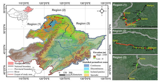
Figure 1.
The topography of Northeast China and location of field monitoring sites (source of permafrost zones [54]).
In Region (1) there are 9 borehole monitoring sites along the Genhe–Labudalin Highway (G332), Mangui–Genhe Provincial Road (S204), and Shiwei–Labudalin Highway (G331) (two sites are about 200 m away from others, so are shown as the same sites in the Figure 1). In Region (2) there are 8 borehole monitoring sites along the Walagan–Xilinji Highway (G111). In Region (3) there are 3 borehole monitoring sites along the Bei’an–Heihe section of the Jilin–Heihe Expressway (G1211) (two sites are about 20 m apart in a straight-line distance, so are shown as the same sites in Figure 1).
2.2. Data Sources
Remote sensing data included the digital elevation model (DEM), MODIS surface temperature, and normalized difference vegetation index (NDVI). The DEM data were derived from the shuttle radar topography mission (SRTM) data of the U.S. Space Shuttle Endeavour (http://www.resdc.cn/data.aspx, accessed on 1 January 2020). The data were projected by a WGS84 ellipsoid with a resolution of 30 m. MODIS data were derived from NASA’s land process distributed data archive center (https://lpdaac.usgs.gov/, accessed on 1 July 2021), the time range was 2001–2020, and the time resolution, respectively, was 8 days and monthly. The data of meteorological station were drawn from the China Meteorological data network (http://cdc.cma.gov.cn/home.do, accessed on 1 April 2020). The time range was 1960–2019, including the observation data of MAAT of basic and benchmark meteorological stations in Northeast China, as well as the geographic information of longitude, latitude and elevation of meteorological stations. The field frozen soil temperature monitoring data were drawn from the MEORS-PGSNEC (Figure 1 and Table 1); the monitoring time and depth, respectively, were 2017–2020, and 4.5~21.5 m. Due to the great disturbance to the ground temperature in the initial stage of construction, data commenced from the second year.

Table 1.
Characteristics and monitoring information of ground temperature boreholes of MEORS-PGSNEC.
2.3. Methods
Satellite sensors estimate surface temperature by detecting the thermal radiation intensity of the surface. Different types of surface coverage will lead to different thermal radiation, and the objects represented by the retrieved surface temperature are also different. In densely vegetated areas, the surface detected by the sensor mainly refers to the vegetation canopy surface, and the surface temperature basically refers to the vegetation canopy temperature. With the different degrees of canopy covering the ground, the surface temperature also represents the mixed average temperature of different degrees of vegetation canopy temperature and ground temperature under the vegetation. The relationship between MODIS LST and meteorological station ground temperature is quite different due to the influence of vegetation coverage [82,83]. Therefore, by taking the normalized difference vegetation index and forest canopy closure as the vegetation factor, which, respectively, reflects vegetation coverage and the degree of canopy covering the ground, the applicability of the MODIS surface temperature product in Northeast China was adjusted.
The vegetation in the study region has obvious lush and withered periods with seasonal changes, and is often covered by snow in winter. In order to avoid abnormal NDVI values caused by snow cover in permafrost regions in winter, the average NDVI value in the annual growing season was selected to represent the overall condition of interannual vegetation coverage [71,84]. NDVI in the six representative areas increased significantly from the beginning of May, and reached its maximum value from June to August (Figure 2a). The maximum value of NDVI in Tahe was in June (NDVI = 0.905); the maximum value of NDVI in other regions was in July–August (NDVI > 0.6), and it dropped rapidly from September to October. By November, the NDVI value had dropped to the level before the obvious increase in May. The vegetation growth season is from May to September, and the mean annual value of NDVI in growing season (MANDVIG) was selected to characterize the overall condition of interannual vegetation coverage. The NDVI value is between ±1, and a negative value indicates that the ground cover is cloud, water, snow, etc. When NDVI = 0, it means that the ground surface is rock or bare soil, etc., and the surface temperature is basically the same as the ground temperature or bare rock surface temperature. Positive values indicate vegetation cover, which increases as the coverage increases; surface temperature refers to the mixed average value of vegetation canopy temperature and ground temperature under vegetation. Therefore, 1 was added to MANDVIG in the calculation in order to eliminate the negative value interval. MANDVIG has a strong correlation with surface temperature on temporal and spatial scales [85]. The surface emissivity estimated from the difference in the vegetation coverage can be used as the basic parameter when inverting the MODIS land surface temperature [86]. MODIS LST products were used, and MANDVIG and forest canopy closure were used as the vegetation factor Et (Equation (1)) to adjust the applicability of MODIS LST products to the study region.
The daily products of MODIS LST may be missing due to cloud cover, but the possibility of having clouds in the same area for 8 consecutive days is very small. The time correlation between remote sensing land surface temperature and meteorological station ground temperature over a long period is obviously better than over a short period [87,88]. Therefore, the 8-day synthetic products MOD11A2 and MYD11A2 (strip numbers: h25v03, h26v03, h25v04, h26v04, and h27v04) of MODIS Terra/Aqua covering the study area from 2003 to 2019 were selected. The MODIS Reprojection Tool (MRT) was used to perform band selection, format conversion, splicing and projection of the original data. The Cell Statistics tool of ArcGIS software was used to calculate the arithmetic mean values of MOD11A2 and MYD11A2 ().

Figure 2.
(a) Monthly NDVI in Northeast China from 2003 to 2019. (b) Distribution of vegetation types in Northeast China (source of vegetation types [89]).
The land surface temperature under the influence of vegetation factor (LSTC) is shown in Equation (2):
where Et is the vegetation factor, t is the time period (t = 2003, 2004,……, 2020), is the mean values of all products in the one year, and εfcc is the forest canopy closure. According to the stand spatial structure [90,91] of the study area and the regulations of FAO, the average εfcc in the study area ranged from 0.2 to 0.69, which is moderate canopy closure. For the convenience of calculation, εfcc was taken as the constant value, which was 0.56.
SFn, defined as the ratio of freezing depth and thawing depth, allows an assessment of the distribution of permafrost on a regional scale [58]. It was calculated using Equation (3), where DDT is the surface thawing index, which was calculated from the daily cumulative value of surface temperature greater than 0 °C from 1 January to 31 December of the current year, as shown in Equation (4); DDF is the surface freezing index, which was calculated from the cumulative value of daily absolute value of surface temperature less than 0 °C from 1 July of each year to 30 June of the next year, as shown in Equation (5).
We define the SFn under the influence of Et-SFnc, as shown in Equation (6).
where is the monthly average value of 8-day data products, m is the month, N is the days of the corresponding month, and t is the year.
The linear trend method was used to reflect the interannual spatial change trend of MANDVIG, and the mean annual LSTc (MALSTc) and SFnc in the study area from 2003 to 2019. The change trend, , calculation equation is:
where is the cumulative number of years during the monitoring period, and is the factors value of year i. Generally speaking, indicates that the change of factors in years is an increasing trend, otherwise it represents a decreasing trend.
3. Results
3.1. Air Temperature Change
Figure 3 shows the change rate of MAAT of national meteorological stations in different regions of China from 1960 to 2019. The change of MAAT in each year means the MAAT change in the time series from 1960 to the specific year. The representativeness of the change rate in a shorter time is slightly lower, therefore, the change rate of MAAT from 1961 to 1964 is not shown. The change rate of MAAT showed an overall increasing trend with time, and the warming rate decreased after 2006. In China, it was higher than 0 since 1987, and the warming effect in the middle and high latitudes showed earlier. Since 1975, the change rate of MAAT in the study area was higher than the national average; specifically, in the middle and high latitudes of the study area, it was higher during the same period.
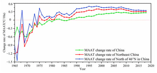
Figure 3.
The change rate of MAAT of national meteorological stations in different regions of China.
The change rate of MAAT for 109 national meteorological stations in the study area from 1960 to 2019 was greater than 0 (in Figure 4a), therefore, it was a warming trend. Compared with the average change rate of MAAT for China during the same period, the stations with a higher change rate of MAAT were mainly concentrated in the north of 46°N of the study area, except for Tahe, Hegang and Fujin. The effect of air temperature rising was amplified in middle and high latitudes. With the increase in altitude and latitude, the change rate had an increasing trend (Figure 4b,c). However, the meteorological stations in the middle and high latitudes were relatively few and unevenly distributed (Figure 4a), therefore, the results may be somewhat one-sided.
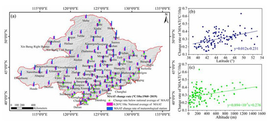
Figure 4.
(a) The change rate of MAAT for national meteorological stations in the study area from 1960 to 2019; comparison of the annual average temperature change rate of national meteorological stations in Northeast China from 1960 to 2019 and the national average annual temperature change rate. (b) The relationship between the change rate of MAAT and latitude of national meteorological stations in the study area. (c) The relationship between the change rate of MAAT and altitude of national meteorological stations in the study area.
3.2. Distribution and Changes of the MANDVIG
The vegetation coverage of GKM, LKM and Changbai Mountains was high, with most cases of MANDVIG between 0.8 and 1, and its slope was relatively small at about ±0.1/year (Figure 5). Some areas in the south of LKM and GKM were covered with broad-leaved forest, in which MANDVIG reached more than 0.9. MANDVIG of the west and southwest was relatively small, between 0 and 0.4, but the interannual variation range and regional differences were large, and the MANDVIG between them and the GKM interlaced area was between 0.6 and 0.7. The northeast plains were dominated by agriculture and animal husbandry production, and here the slope of MANDVIG was above 0.1/year. The vegetation coverage in these areas was mainly affected by the interference of human activities, which has produced extremely significant feedback.
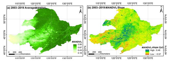
Figure 5.
Distribution and change trend of MANDVIG in Northeast China from 2003 to 2019.
3.3. Distribution and Variation of MALSTc
Surface temperature in a permafrost region is a sensitive indicator of heat exchange; it has a more direct impact on the thermal state of permafrost than air temperature, and its changes directly affect the distribution and changes of permafrost [31]. The areas with mean MALSTc from 2003 to 2019 lower than 0 °C were mainly distributed in GKM and LKM, and a small area of Changbai Mountains (Figure 6). In the study area, the GKM was the area with the lowest MALSTc, which, at lower than −5 °C, was mainly distributed in the northwest foot of GKM, with a very small area and sporadic distribution. The GKM, LKM and Changbai Mountains were the main permafrost distribution areas in the study area, and the MALSTc increased in varying degrees. The MALSTc in GKM increased by 1.1 °C on average, and with a large range of temperature rises and a large proportion of rising areas. The MALSTc in some parts of the northern and southern LKM decreased, but the area of Sunwu County to Aihui City located in the middle of LKM increased significantly, with rises to over 2 °C. The MALSTc in Hulunbuir Plateau increased by 2.28 °C, on average. From 2003 to 2019, the MALSTc in 76.2% of the study area increased, with a cumulative increase of 0.75 °C; in 86.8% of the north of 46°N of the study area, it increased by 1.13 °C. The area where the MALSTc was lower than 0 °C reduced from 21.98 × 10⁴ km2 to 14.80 × 10⁴ km2, with an area reduction of 32.67%. Both MALSTc and MANDVIG showed an overall upward trend with a growth rate of 0.0017/a and 0.0147 °C/a, respectively.
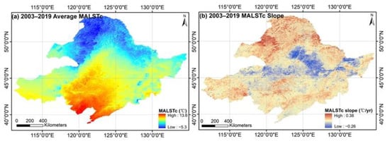
Figure 6.
Distribution and change trend of MALSTc in Northeast China from 2003 to 2019.
3.4. Distribution and Change of SFnc
SFn can reflect the surface thermal state; when the surface freezing index is greater than the thawing index (i.e., SFn > 0.5), the possibility of permafrost is high [31]. With an increase in latitude, permafrost distribution changes from sporadic to island to continuous distribution, and the southern boundary of permafrost was distributed in a “W” shape extending to Arshan in the south, and to Yichun in the east. It was also distributed in Huanggangliang at the southern end of GKM and Changbai Mountains. The regions with larger SFnc also had a relatively high altitude and high latitude, and regions with SFnc greater than 0.55 were mainly distributed in the northwest of GKM, where the continuous permafrost distribution area was not continuously distributed in large areas, but in island distribution (in Figure 5). The regions with SFnc greater than 0.5 were distributed in both GKM and LKM, which were the main permafrost distribution areas within the study area. It can be seen from Figure 7b that SFnc in GKM, LKM and Changbai Mountains showed a downward trend. The average SFnc in the north of 46°N of the study area decreased by 0.014, and in Great Kinggan Mountains it decreased by 0.02, from 2003 to 2019. The change range of SFnc in GKM was greater than that in LKM. However, the SFnc in LKM was relatively small, and the permafrost was mainly distributed in sporadic and island areas, which are vulnerable to the disturbance of external environmental changes; even small environmental geological changes will lead to the degradation of permafrost.
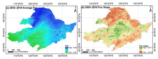
Figure 7.
Distribution and change trend of SFnc in Northeast China from 2003 to 2019.
3.5. Distribution and Change of Permafrost Thermal State
Nan et al. [61] caused SFn to have a clear physical meaning by re-deriving the model. When SFn ≈ 0.667 or 2/3, it is the threshold of continuous and non-continuous permafrost [58], which means that the surface freezing index is twice the thawing index. When SFn ≈ 0.5, it is the boundary index between seasonal frozen soil and permafrost, and the permafrost is in a transitional and unstable state. Based on the above two thresholds, we set a buffer zone of 0.1 as the division threshold in the case of SFn ≈ 0.5, because the surface freezing index and thawing index are approximately equal, or the annual average surface temperature is 0 °C. SFn is an empirical model, and SFn = 0.55 was set according to a large number of field investigations, survey data and monitoring results, when it is applied in this study. We proposed the classification standard of permafrost in different thermally-stable states, in Northeast China to be as follows:
- Extremely stable permafrost, SFnc ≥ 0.667;
- Stable permafrost, 0.55 ≤ SFnc < 0.667;
- Semi-stable permafrost, 0.51 < SFnc < 0.55;
- Transitional or unstable permafrost, 0.49 ≤ SFnc ≤ 0.51.
According to the classification standard, we calculated the area of different thermal state types of permafrost from 2003 to 2019. We calculated the average MAAT in stable permafrost regions including Mohe, Tulihe, Erguna and Aershan national meteorological stations, and in semi-stable permafrost regions including Tahe, Sunwu, Aihui, Bei’an, Nenjiang, Xiaoergou, Xinlin and Huma national meteorological stations. The time mutation point of the area of stable permafrost was 2013, and there was no obvious change in the area of semi-stable permafrost (Figure 8b,c). Therefore, the change of thermal state of permafrost in Northeast China was divided into two periods: 2003–2013 and 2014–2019. From 2003 to 2013, the area of stable permafrost changed greatly in 2007, 2009 and 2012, and the distribution area in other years fluctuated slightly, ranging from 12.08 to 16.7 × 10⁴ km2. The average MAAT range in the region was −4~−3 °C, and the correlation coefficient between average MAAT and area was −.81. The increase in MAAT had a significant impact on the change of stable permafrost distribution. The area of stable permafrost from 2014 to 2019 changed greatly, with anomalies in 2016 and 2018, and the area in other years was always lower than the previous period. The average MAAT ranged from −3 to −2 °C, and the correlation coefficient with the area was −0.25. Over seventeen years, the average MAAT increased by nearly 1 °C. In general, the area anomalies of semi-stable permafrost were larger in 2007, 2012 and 2018, and the range of area in other years ranged from 13.8 to 20.8 × 10⁴ km2. The correlation coefficient between area and average MAAT was −0.59.
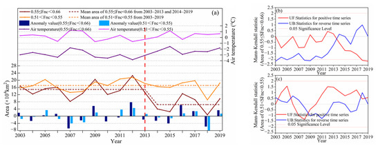
Figure 8.
(a) The change curves of area and average MAAT of different thermal states of permafrost in Northeast China from 2003 to 2019. (b) Mann–Kendall test of stable permafrost area. (c) Mann–Kendall test [92] of semi-stable permafrost area.
According to the classification standard and time variation characteristics of the thermal state of permafrost, the distribution and change of the thermal state of permafrost is shown in Figure 9. Stable permafrost was mainly distributed in the continuous permafrost region, namely, the GKM, and a small amount in Changbai Mountains and the northern foot of the LKM, with an area of 14.9 × 10⁴ km2 reduced to 6.5 × 10⁴ km2 over the study period; the SFnc was reduced from 0.564 to 0.557. Semi-stable permafrost was mainly distributed at the edge of continuous permafrost area; the island permafrost region, that is, the edge of stable permafrost region in GKM, and most of the region of LKM, with an area of 17.68 × 10⁴ km2, changed to 17.77 × 10⁴ km2, and the SFnc decreased from 0.529 to 0.528. The area and SFnc changed little, but the permafrost distribution region changed significantly. The transitional or unstable permafrost was in the degradation stage and very sensitive to changes of the external environment, and mainly distributed at the edge of the island permafrost region and near the melting region. It also had a relatively high annual average ground temperature, and the annual heat absorption and heat dissipation of soil layer were approximately equal; the permafrost area changed from 8.67 × 10⁴ km2 to 9.56 × 10⁴ km2, and the increased area was due to the thawing of edge regions of permafrost with a higher thermal state, and increasing and expanding of island thawing regions. In addition, it can be seen from Figure 9 that there was no extremely stable permafrost in Northeast China. In terms of spatial distribution, the permafrost showed a regional degradation trend from south to north; the degradation of stable permafrost was characterized by gradual thawing from the edge to the center of the permafrost distribution area and the increase of island thawing area; the degradation of semi-stable permafrost was characterized by the thawing or disappearance of the edge of the permafrost distribution area and the expansion of island thawing area.
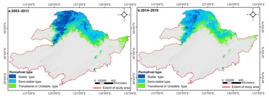
Figure 9.
Spatial distribution and changes of the thermal state of permafrost in Northeast China.
3.6. Indirect Verification
Relative Accuracy of MODIS LSTC
By comparing the correlation between borehole soil temperature monitoring data and MODIS LSTC data on a monthly scale, the applicability of MODIS LST data under the influence of surface vegetation factors in the study area was analyzed. At the same time, we also verified the classification results of thermal state types of permafrost (Figure 10 and Figure 11).
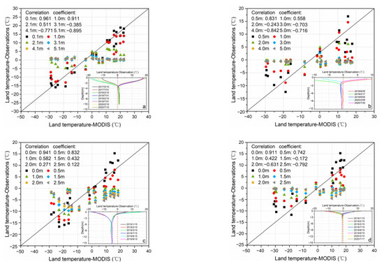
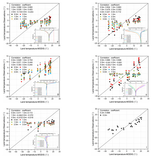
Figure 10.
Comparison of MODIS LSTc, borehole soil temperature monitoring data, and borehole ground temperature envelope line, in 2017–2020: (a) the monitoring site SL4, (b–d) the monitoring site GL1, GM1 and GM2, (e–h) the monitoring site WX5, WX3, WX1 and WX2, (i,j) the monitoring site BH1 and BH3.
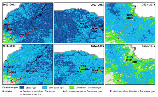
Figure 11.
Comparison between the thermal state of permafrost of monitoring sites and classification results, from 2003 to 2019 in Northeast China.
The following results can be drawn from the correlation diagram, and the ground temperature envelope line between the monthly average data of the borehole ground temperature and the monthly value of the LSTc data. The SL4 monitoring site along the Shiwei–Labudalin Highway was a section of seasonal frozen soil (Figure 10a). The monitoring sites GL1 (Figure 10b), GM1 and GM2 (Figure 10c,d) were permafrost sections, respectively, along the Genhe–Labudalin Highway and Genhe–Mangui Provincial Road; the annual heat dissipation of the soil layer in monitoring sites GL1 and GM1 was greater than the heat absorption, the permafrost state was stable; the annual heat dissipation of the soil layer in monitoring site GM2 was equal to the heat absorption, and the permafrost was sensitive to external changes and easily disturbable. The monitoring sites WX5, WX3, WX1 and WX2 (Figure 10e–h) were permafrost sections, located along the Walagan–Zhangling Highway; the annual heat dissipation of the soil layer in monitoring sites WX5 and WX2 was equal to the heat absorption, and the annual heat dissipation of the soil layer in monitoring sites WX3 and WX1 was approximately equal to the heat absorption; all permafrost areas were in the degradation stage, sensitive to external changes and easily disturbable. The monitoring sites BH1 and BH3 (Figure 10i,j) were island permafrost sections in the Bei’an–Heihe section of Jilin–Heihe expressway, and the permafrost was in the degradation stage. The monitoring site BH2 was located in low-lying swamp wetland with perennial ponding, covered with hydrophilous vegetation such as hassock and moss, humus soil and peat soil in the soil layer, which hindered the heat exchange between the soil and air; moreover, the phase change latent heat of water also affected the change of ground temperature [21]. Compared with monitoring site BH3, site BH1 was very close to the edge of the highway and was obviously affected by human activities, therefore, the correlation between the ground temperature data of site BH1 and MODIS LSTC data was slightly low. Taking 0 °C as the basis for judging soil freezing or thawing, we found that the temperature data in the depth range of the active layer have strong correlation, and the correlation coefficient decreased gradually with the increase in depth. In addition, due to the influence of the highway, the data correlation between MODIS LSTC and the monitoring sites close to the highway was relatively low.
3.7. Relative Accuracy of Classification Standard
The ground temperature envelope was drawn through the ground temperature monitoring data at different depths of the borehole (Figure 10 and Figure 11). Assuming that 0 °C is used as the basis for judging soil freezing or thawing, the state of permafrost can be judged from the perspective of ground temperature, according to the different shapes of the ground temperature envelope. Region (1) showed that seven monitoring sites were stable permafrost, two monitoring sites were semi-stable permafrost, and one monitoring site was seasonal permafrost; only monitoring site SL4 was different from the classification results. Region (2) showed that six monitoring sites were semi-stable permafrost, and two monitoring sites (WX6 and WX7) were seasonal permafrost, which were different from the classification results; however, it can be seen from the ground temperature monitoring curves that the permafrost areas at these two sites were originally in a semi-thermal state, and the permafrost had been completely thawed by 2019 due to being significantly affected by special geological conditions and engineering disturbance. This local difference caused by external factors cannot be widely and accurately measured, and is not within the range of influencing factors considered in the article; therefore, after ignoring the immeasurable factors, sites WX6 and WX7 were consistent with the classification results. In Region (3), the three monitoring sites were transitional or unstable permafrost, which were consistent with the classification results.
By comparing and analyzing the borehole monitoring data and the thermal state of permafrost distribution map in the three representative regions in Northeast China, it can be seen that: Region (1) was the main distribution area of stable permafrost, the thickness of the active layer was generally 1.5 m, and the annual average ground temperature was −5~−2 °C; under the background of climate warming, the stable permafrost had also undergone obvious degradation in recent years. Region (2) was the semi-stable permafrost formed after the degradation of stable permafrost; the thickness of the active layer was deeper, by up to more than 3 m, and the annual average ground temperature was −2~−0.5 °C; due to the proximity to the surrounding transitional or unstable permafrost, the annual average ground temperature of sites WX1,WX2 and WX3 were relatively, at −0.6 °C, −0.2 °C and −0.8 °C, respectively, higher than site WX5 (−2 °C). The semi-stable permafrost degraded to form transitional or unstable permafrost in Region (3), which was mostly island or sporadic permafrost with a thawing layer under the frozen layer.
Under the influence of surface vegetation factors, remote sensing surface temperature data can maintain high correlation with borehole monitoring data. Except for the two boreholes WX6 and WX7 which were greatly disturbed by the project, 19 of the 20 monitoring sites were consistent with the classification results, with an accuracy of nearly 95%. Therefore, the thermal state of permafrost distribution based on MODIS LSTC data has high reliability.
4. Discussion
4.1. Topographic Distribution Characteristics of the Thermal State of Permafrost
The topographic distribution characteristics of the thermal state of permafrost are shown in Figure 12. Permafrost was mainly distributed between 47°N to 53°N; the stable permafrost was distributed in areas with relatively high altitude, which was the main factor controlling the permafrost distribution. Within the same latitude, permafrost in high altitude areas has higher stability, therefore, the permafrost in GKM was more developed and stable than that in LKM; island permafrost was mainly developed in LKM, which was mainly in the transition stage of semi-thermal state and degradation. The proportions of different thermal states of permafrost on shady slopes were 50.9~52.3%; compared with the advantage of slope aspect on local influence on permafrost distribution [93], the influence of slope aspect on permafrost distribution gradually weakened with the increase in spatial scale [94]. The altitude curve had two peak values because the semi-stable permafrost was distributed in both the GKM and LKM. The stable and semi-stable permafrost degradation mainly occurred in the areas with relatively low elevation and sunny slope.
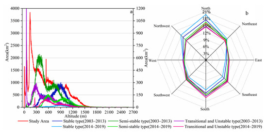
Figure 12.
Altitude and slope distribution of different thermal states of permafrost in Northeast China. (a) The altitude of the study area corresponds to the principal coordinate axis, and the altitude of different thermal states of permafrost corresponds to the secondary coordinate axis. (b) Percentage represents the ratio of different slope directions of different thermal states to the total distribution of their slope directions.
4.2. Temporal and Spatial Variation Characteristics of Thermal State of Permafrost
Changes in the thermal state of permafrost are the result of long-term accumulation, which is affected by many factors. Based on SFnc from 2003 to 2019, the variation characteristics of thermal state of permafrost were analyzed, based on the spatial change of the geometric center of the distribution region of SFnc with different percentile intervals (95th–100th percentile). As shown in Figure 13, SFnc showed a decreasing trend, from 0.674 to 0.628; in terms of latitude, the geometric mid-point latitude fluctuated within a range of 0.5° above and below approximately 51.8°N, which was stable permafrost in the study area. The core area of the soil was near 51.8°N, which was not the highest latitude area. From the perspective of longitude and elevation changes, the Fnc extreme point has moved eastward by at least 1°, and the elevation has risen by at least 100 m. Based on the above information, we infer that in the past 20 years, the ratio of heat released to the surface of the study area to absorbed heat has decreased, which may be related to the decrease in the degree of coldness in the cold season.
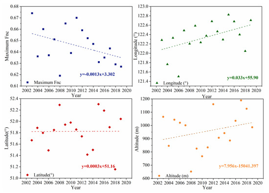
Figure 13.
The spatial changes of the geometric center of the distribution region of SFnc with different percentile intervals (95th–100th percentile).
4.3. Influencing Factors of Changes in Thermal State of Permafrost
On a large regional scale, the formation, development, and distribution of permafrost are mainly controlled by latitude, altitude, climatic conditions, and topographic factors. There are also spatial differences in local areas due to factors such as soil properties, soil moisture, vegetation structure, precipitation, snow cover and terrain. Figure 14 shows MAAT and MANDVIG changes in the distribution area of stable and semi-stable permafrost from 2003 to 2019. From 2003 to 2019, the correlations between the area of stable and semi-stable permafrost and the MAAT and MANDVIG were −0.76, −0.12, −0.44 and −0.14, respectively; from 2003 to 2013, the correlation coefficients were, respectively, −0.81, −0.68, −0.59 and −0.16. It can be seen that air temperature was the main factor affecting the change of thermal state of permafrost, especially in 2012–2015, when the correlation between the area of stable permafrost and the temperature change in the region reached −0.96. Degradation of permafrost can provide soil moisture and nutrients for vegetation growth in the short term, and promote vegetation growth, but in the long run, after permafrost continues to degrade, it will cause surface water infiltration, migration and reduction in soil water content through surface evapotranspiration, thereby hindering vegetation growth [95]. From 1956 to 2017, the precipitation in Northeast China showed a fluctuating decreasing trend. The annual precipitation was lowest in 2001 (377.66 mm), and highest in 2013 (649.02 mm) [96]. The increase in precipitation may promote the thawing of permafrost [97], and the thermal stability of permafrost in the study area changed significantly under the superposition of air temperature.
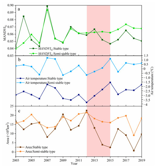
Figure 14.
The different thermal state types of permafrost in Northeast China from 2003 to 2019 of (a) the MAAT changes, (b) the MANDVIG changes, (c) the area changes.
4.4. Uncertainty Analysis
The 8-day synthetic products of MODIS still exist due to the presence of clouds that cause local values to be missing. The missing values could be filled by interpolation [62,63]. This process should consider topography (slope and elevation) and seasonal changes in vegetation. The reliability and accuracy of the interpolation results also would need certain data to verify them. Therefore, the missing values that may be caused by cloud cover were ignored in this article.
The application of forest canopy closure εfcc in this article was based on moderate canopy closure; the proportion of the total NDVI of different representative regions in the growing season and the total annual NDVI of 56.2~88.8% was used as the reference standard for the value of εfcc. The vegetation types in the permafrost region in Northeast China are mainly coniferous, broad-leaved forests, and mixed coniferous and broad-leaved forests. The vegetation is dense and the average NDVI in the growing season can reach 0.8 or more. Therefore, vegetation type was not used as a reference factor for the value of εfcc. εfcc was determined based on the thermal state distribution map of permafrost and field site monitoring data, and the result reached a relatively ideal accuracy. Of course, to obtain a more accurate and detailed map of permafrost stability, more comprehensive influencing factors should be considered, which may require data support from further, different fields.
Considering the frost number model of the ground cover vegetation, areas of frozen soil distribution could be obtained with more consistent field observation data. However, limited by the small number of ground monitoring stations and the short continuous time of data, it failed to provide a more long-term (2003–2013) and sufficient verification of the changes in the distribution of permafrost. In addition, according to the survey of roads under construction and already built, the depth range of soil replacement treatment in the permafrost section of the road did not exceed 4–5 m, and the deep permafrost was not significant to the ground structure, and was not easy to monitor. On one hand, due to the limitations of remote sensing data on surface observations, and the impact of climate change on ground temperature gradually weakening with increasing depth, the discussion of permafrost and its southern boundary in this article should be within the depth of 19 m (the maximum depth of field monitoring in general) of permafrost near the surface.
5. Conclusions
Based on meteorological station and MODIS LST data, the distribution and changes of air temperature, surface temperature, MANDVIG and Fnc in Northeast China were analyzed from 2003 to 2019, and the following conclusions were drawn:
- (1)
- From 2003 to 2019, MALSTc in 76.2% of Northeast China, and in 86.8% of the north of the south boundary of permafrost in Northeast China, showed an upward trend. From 1960 to 2019, the air temperature rise rate in permafrost areas of Northeast China was 0.47 °C/10a, which was higher than the national average level, especially in Aihui County (0.44 °C/10a), Sunwu County (0.63 °C/10a), and Huma County (0.44 °C/10a); the permafrost regional degradation in these areas was significant. Climate warming was the main factor leading to permafrost degradation. Permafrost degradation mainly occurred in relatively low altitude and sunny slope areas;
- (2)
- Taking into account Fnc under the influence of NDVI and forest canopy density as the standard, we classified the types of thermally stable permafrost in Northeast China as divided into: extremely stable permafrost, SFnc ≥ 0.66; stable permafrost, 0.55 ≤ SFnc < 0.66; semi-stable permafrost, 0.51 < SFnc < 0.55; transitional or unstable permafrost, 0.49 ≤ SFnc ≤ 0.51; and deep seasonal frozen soil (maximum frozen depth > 1.8 m), 0.40 ≤ SFnc < 0.49. The consistency between the thermal stability of permafrost and the field monitoring data reached 95%;
- (3)
- The year 2013 was a turning point in the process of permafrost thawing in Northeast China. Around this time point, the air temperature in the stable permafrost area increased by nearly 1 °C, SFnc decreased from 0.564 to 0.557, and MANDVIG decreased. The average air temperature in the semi-stable permafrost area increased by 0.36 °C, SFnc decreased from 0.529 to 0.528, and MANDVIG increased. There was no extremely stable permafrost in Northeast China. The area of stable permafrost changed from 14.9 × 10⁴ km2 to 6.5 × 10⁴ km2, the area of semi-stable permafrost changed from 17.68 × 10⁴ km2 to 17.77 × 10⁴ km2; changes were mainly reflected in the obvious northward movement of the southern boundary of the distribution range, and the increase in the number and area of island thawing areas in the region. The area of transitional or unstable permafrost changed from 8.67 × 10⁴ km2 to 9.56 × 10⁴ km2, the slight increase in the area was mainly reflected in the continuous thawing of the edge of the higher stable permafrost;
- (4)
- The continued increase in air temperature was the main reason for the degradation of stable permafrost.
Author Contributions
Conceptualization, W.S.; data curation, W.S., C.Z. and Y.G.; formal analysis, C.Z.; funding acquisition, W.S.; investigation, W.S. and Y.G.; methodology, W.S. and C.Z.; project administration, W.S. and Y.G.; resources, W.S.; software, C.Z. and L.Q.; validation, C.Z.; visualization, C.Z. and L.Q.; writing—original draft, W.S. and C.Z.; writing—review and editing, W.S., C.Z., Y.G. and L.Q. All authors have read and agreed to the published version of the manuscript.
Funding
We thank the National Natural Science Foundation of China (Grant No. 41641024) and Science and the Technology Project of Heilongjiang Communications Investment Group (Grant No. JT-100000-ZC-FW-2021-0182) for providing financial support and the Field scientific observation and research station of the Ministry of Education-Geological environment system of permafrost area in Northeast China (MEORS-PGSNEC).
Data Availability Statement
Related data are available upon reasonable request.
Conflicts of Interest
The authors declare no conflict of interest.
References
- Qin, D.; Yao, T.; Ding, Y.; Ren, J. Glossary of Cryosphere Science; China Meteorological Press: Beijing, China, 2014. [Google Scholar]
- Zhang, T.; Barry, R.; Knowles, K.; Heginbottom, J.A.; Brown, J. Statistics and characteristics of permafrost and ground-ice distribution in the Northern Hemisphere. Polar Geogr. 2008, 31, 47–68. [Google Scholar] [CrossRef]
- Bockheim, J.G.; Hall, K.J. Permafrost, active-layer dynamics and periglacial environments of continental Antarctica: Periglacial and permafrost research in the Southern Hemisphere. S. Afr. J. Sci. 2002, 98, 82–90. [Google Scholar]
- Yang, J.P.; Yang, S.Q.; Li, M.; Tan, C.P. Vulnerability of frozen ground to climate change in China. J. Glaciol. Geocryol. 2013, 35, 1436–1445. [Google Scholar]
- Peng, X.; Zhang, T.; Frauenfeld, O.W.; Wang, K.; Luo, D.L.; Cao, B.; Su, H.; Jin, H.J.; Wu, Q.B. Spatio-temporal changes in active layer thickness under contemporary and projected climate in the Northern Hemisphere. J. Clim. 2018, 31, 251–266. [Google Scholar] [CrossRef]
- Witharana, C.; Bhuiyan, A.E.; Liljedahl, A.; Kanevskiy, M.; Jorgenson, T.; Jones, B.; Daanen, R.; Epstein, H.; Griffin, C.; Kent, K.; et al. An object-based approach for mapping tundra ice-wedge polygon troughs from very high spatial resolution optical satellite imagery. Remote Sens. 2021, 13, 558. [Google Scholar] [CrossRef]
- Zhang, K.; Kimball, J.S.; Kim, Y.; McDonald, K.C. Changing freeze-thaw seasons in northern high latitudes and associated influences on evapotranspiration. Hydrol. Processes 2011, 25, 4142–4151. [Google Scholar] [CrossRef]
- Liljedahl, A.K.; Boike, J.; Daanen, R.P.; Fedorov, A.N.; Frost, G.V.; Grosse, G.; Hinzman, L.D.; Iijma, Y.; Jorgen-son, J.C.; Matveyeva, N.; et al. Pan-Arctic ice-wedge degradation in warming permafrost and its influence on tundra hydrology. Nat. Geosci. 2016, 9, 312–318. [Google Scholar] [CrossRef]
- Ma, J.; Li, R.; Liu, H. A review on the development of study on hydrothermal characteristics of active layer in permafrost areas in Qinghai-Tibet Plateau. J. Glaciol. Geocryol. 2020, 42, 195–204. [Google Scholar]
- Hu, G.; Zhao, L.; Li, R.; Wu, T.H.; Pang, Q.; Wu, X.D.; Qiao, Y.P.; Shi, J.Z. Characteristics of hydro-thermal transfer during freezing and thawing period in permafrost regions. Soils 2014, 46, 355–360. [Google Scholar]
- He, P.; Cheng, G.; Zhu, Y. The progress of study on heat and mass transfer in freezing soils. J. Glaciol. Geocryol. 2001, 23, 92–98. [Google Scholar]
- Yang, S.; Li, R.; Wu, T. The variation characteristics of different freeze-thaw status in the near surface and the relationship with temperature over the Qinghai-Tibet Plateau. J. Glaciol. Geocryol. 2019, 41, 1377–1387. [Google Scholar]
- Yang, C.; Wu, T.; Yao, J.; Li, R.; Xie, C.; Hu, G.; Zhu, X.; Hao, J.; Ni, J.; Li, X. Temporal and spatial characteristics of ground surface soil heat flux over the Qinghai-Tibetan Plateau. Plateau Meteorol. 2020, 39, 706–718. [Google Scholar] [CrossRef]
- Qin, Y.; Wu, T.; Li, R.; Hu, G.; Qiao, Y.; Zhu, X.; Yang, S.; Yu, W.; Wang, W. Thermal condition of the active layer on the Qinghai-Tibet Plateau simulated by using the Model of GIPL2. J. Glaciol. Geocryol. 2018, 40, 1153–1166. [Google Scholar]
- Cheng, G.; Hao, J.; Wang, K.; Wu, Q.B. Thawing index and freezing index on the embankment surface in permafrost regions. J. Glaciol. Geocryol. 2003, 25, 603–607. [Google Scholar]
- Nan, Z.; Li, S.; Cheng, G. Surface frost number model and its application to the Tibetan Plateau. J. Glaciol. Geocryol. 2012, 34, 89–95. [Google Scholar]
- IPCC. Working Group I Contribution to the Sixth Assessment Report (AR6) of the IPCC: Climate Change 2021—The Physical Science Basis; Cambridge University Press: Cambridge, UK, 2021. [Google Scholar]
- Solomon, S. Climate Change 2007: The Physical Science Bases: Working Group I Contribution to the Fourth Assessment Report of the IPCC; Cambridge University Press: Cambridge, UK, 2007. [Google Scholar]
- Shan, W.; Xu, Z.; Guo, Y.; Zhang, C.; Hu, Z.; Wang, Y. Geological methane emissions and wildfire risk in the degraded permafrost area of the Xiao Xing’an Mountains, China. Sci. Rep. 2020, 10, 21297. [Google Scholar] [CrossRef]
- Xiao, C.D.; Wang, S.J.; Qin, D.H. A preliminary study of cryosphere service function and value evaluation. Adv. Clim. Chang. Res. 2015, 6, 181–187. [Google Scholar] [CrossRef]
- Guo, Y.; Shan, W.; Zhang, C.; Hu, Z.; Wang, S.; Gao, J. Monitoring of permafrost degradation along the Bei’an-Heihe Expressway in China. Bull. Eng. Geol. Environ. 2020, 16, 1–10. [Google Scholar] [CrossRef]
- Beijing Climate Centre. Blue Book on China’s Climate Change. China’s Ecological Climate Is Generally Getting Better; Beijing Climate Centre: Beijing, China, 2020. (In Chinese) [Google Scholar]
- Zhao, Z.C.; Luo, Y.; Huang, J.B. Review of IPCC 30 years (1988–2018). Prog. Clim. Chang. Res. 2018, 14, 540–546. (In Chinese) [Google Scholar]
- Overduin, P.P.; Westermann, S.; Yoshikawa, K.; Haberlau, T.; Romanovsky, V.; Wetterich, S. Geoelectric observations of the degradation of nearshore submarine permafrost at Barrow (Alaskan Beaufort Sea). J. Geophys. Res. Earth Surf. 2012, 117, F02004. [Google Scholar] [CrossRef]
- Zhang, T. Progress in global permafrost and climate change studies. Adv. Earth Sci. 2012, 32, 27–38. [Google Scholar]
- Qingbai, W.; Yongzhi, L. Ground temperature monitoring and its recent change in Qinghai-Tibet Plateau. Cold Reg. Sci. Technol. 2004, 38, 85–92. [Google Scholar] [CrossRef]
- Harris, C.; Arenson, L.U.; Christiansen, H.H.; Etzelmüller, B.; Frauenfelder, R.; Gruber, S.; Haeberli, W.; Hauck, C.; Hölzle, M.; Humlum, O.; et al. Permafrost and climate in Europe: Monitoring and modelling thermal, geomorphological and geotechnical responses. Earth Sci. Rev. 2009, 92, 117–171. [Google Scholar] [CrossRef]
- Yang, M.; Nelson, F.E.; Shiklomanov, N.I.; Guo, D.; Wan, G. Permafrost degradation and its environmental effects on the Tibetan Plateau: A review of recent research. Earth Sci. Rev. 2010, 103, 31–44. [Google Scholar] [CrossRef]
- Zhou, Y.W.; Guo, D.X.; Qiu, G.Q.; Cheng, G.D. Frozen Soil in China; Science Press: Beijing, China, 2000. (In Chinese) [Google Scholar]
- Zhou, Y.W.; Guo, D.X.; Qiu, G.Q. China Permafrost; Science Press: Beijing, China, 2000. (In Chinese) [Google Scholar]
- Wei, Z.; Jin, H.; Zhang, J.; Yu, S.; Han, X.; Ji, Y.; He, R.; Chang, X. Prediction of permafrost change in northeast China under climate change. Sci. China Earth Sci. 2011, 41, 74–84. (In Chinese) [Google Scholar]
- Sun, G.Y. Discussion on the symbiotic mechanisms of swamp with permafrost—Taking Da-Xiao Hinggan Mountains as examples. J. Glaciol. Geocryol. 2000, 22, 309–316. (In Chinese) [Google Scholar]
- Guo, D.X.; Wang, S.L.; Lu, G.W.; Dai, J.B.; Li, E.Y. Division of permafrost regions in Daxiao Hinggan Ling northeast China. J. Glaciol. Geocryol. 1981, 3, 1–9. (In Chinese) [Google Scholar]
- Zuo, H.C.; Lu, S.H.; Hu, Y.Q. Variations trend of yearly mean air temperature and precipitain in China in the last 50 years. Plateau Meteorol. 2004, 23, 238–244. [Google Scholar]
- Chen, L.X.; Zhou, X.J.; Li, W.L.; Luo, Y.F.; Zhu, W.Q. Characteristics of the climate change and its formation mechanism in China in last 80 years. Acta Meteorol. Sin. 2004, 62, 634–646. [Google Scholar]
- Ren, G.Y. Climate changes of China’s mainland over the past half century. Acta Meteorol. Sin. 2005, 63, 942–955. [Google Scholar]
- He, W.; Bu, R.C.; Xiong, Z.P.; Hu, Y.M. Characteristics of temperature and precipitation in Northeastern China from 1961 to 2005. Acta Ecol. Sin. 2013, 33, 519–531. [Google Scholar] [CrossRef]
- Wei, Z.; Jin, H.J.; Luo, C.X.; Zhang, J.M.; Lu, L.Z.; Yang, S.Z.; Ji, Y.J. Characteristics of atmospheric environmental changes of permafrost in northeastern China in 50 years. J. Lanzhou Univ. Nat. Sci. 2008, 44, 39–42. [Google Scholar]
- Gu, Z.W.; Zhou, Y.W. The effects of climate warming and human turbulence on the permafrost in the northward slope of MT. Da Hinggan Ling: Take a sample from Amur area. Acta Geogr. Sin. 1994, 49, 182–187. (In Chinese) [Google Scholar]
- Wang, C.J.; Shan, M.N.; Hu, Z.G.; Wei, S. Multi-spectral remote sensing based land surface temperature retrieval and isolated permafrost zone segmentation. Infrared Laser Eng. 2015, 44, 1390–1396. (In Chinese) [Google Scholar]
- Zhou, Y.W.; Wang, Y.X.; Gao, X.W.; Yue, H.S. Ground temperature, permafrost distribution and climate warming in Northeastern China. J. Glaciol. Geocryol. 1996, 18, 139–147. (In Chinese) [Google Scholar]
- Chang, X.L.; Jin, H.J.; He, R.X.; Jing, H.Y.; Li, G.Y.; Wang, Y.P.; Luo, D.L.; Yu, S.P.; Sun, H.P. Review of permafrost monitoring in the northern Da Hinggan Mountains, Northeast China. J. Glaciol. Geocryol. 2013, 35, 93–100. (In Chinese) [Google Scholar]
- Wang, C.H.; Zhang, B.L.; Liu, F.T. A preliminary analysis on the regularity of permafrost degradation, its advantages and disadvantages in the Great and Lesser Xing’an Mountains. J. Glaciol. Geocryol. 1996, 18, 174–180. (In Chinese) [Google Scholar]
- Jin, H.J.; Li, S.X.; Wang, S.L.; Zhao, L. Impacts of climatic change on permafrost and cold regions environments in China. Acta Geogr. Sin. 2000, 55, 161–173. (In Chinese) [Google Scholar]
- Chen, S.S.; Zang, S.Y.; Sun, L. Characteristics of permafrost degradation in Northeast China and its ecological effects: A review. Sci. Cold Arid Reg. 2020, 12, 1–11. [Google Scholar]
- Jin, H.; Yu, Q.; Lü, L.; Guo, D.; He, R.; Yu, S.; Sun, G.; Li, Y. Degradation of permafrost in the Xing’anling Mountains, northeastern China. Permafr. Periglac. Processes 2007, 18, 245–258. [Google Scholar] [CrossRef]
- Brown, J.; Ferrians, O.J., Jr.; Heginbottom, J.A.; Melnikov, E.S. Circum-Arctic Map of Permafrost and Ground-Ice Conditions; US Geological Survey: Reston, VA, USA, 1997.
- Gruber, S. Derivation and analysis of a high-resolution estimate of global permafrost zonation. Cryosphere 2012, 6, 221–233. [Google Scholar] [CrossRef]
- Li, A.; Xia, C.; Bao, C.; Yin, G. Using MODIS land surface temperatures for permafrost thermal modeling in Beiluhe Basin on the Qinghai-Tibet Plateau. Sensors 2019, 19, 4200. [Google Scholar] [CrossRef]
- Xia, K.; Luo, Y.; Li, W. Simulation of freezing and melting of soil on the northeast Tibetan Plateau. Chin. Sci. Bull. 2011, 56, 2145–2155. [Google Scholar] [CrossRef][Green Version]
- Marchand, N.; Royer, A.; Krinner, G.; Roy, A.; Langlois, A.; Vargel, C. Snow-covered soil temperature retrieval in Canadian Arctic permafrost areas, using a land surface scheme informed with satellite remote sensing data. Remote Sens. 2018, 10, 1703. [Google Scholar] [CrossRef]
- Wang, Z.; Nan, Z.; Zhao, L. The applicability of the MODIS land surface temperature products to simulating the permafrost distribution over the Tibetan Plateau. J. Glaciol. Geocryol. 2011, 33, 132–143. [Google Scholar]
- Wang, T.; Wu, T.; Wang, P.; Li, R.; Xie, C.; Zou, D. Spatial distribution and changes of permafrost on the Qinghai-Tibet Plateau revealed by statistical models during the period of 1980 to 2010. Sci. Total Environ. 2019, 650, 661–670. [Google Scholar] [CrossRef]
- Obu, J.; Westermann, S.; Bartsch, A. Northern Hemisphere permafrost map based on TTOP modelling for 2000–2016 at 1 km2 scale. Earth-Sci. Rev. 2019, 193, 299–316. [Google Scholar] [CrossRef]
- Nelson, F.E. Permafrost distribution in Central Canada: Applications of a climate-based predictive mode. Ann. Assoc. Am. Geogr. 1986, 76, 550–569. [Google Scholar] [CrossRef]
- Nelson, F.E.; Anisimov, O.A. Permafrost zonation in Russia under anthropogenic climatic change. Permafr. Periglac. Processes 1993, 4, 137–148. [Google Scholar] [CrossRef]
- Anisimov, O.A.; Nelson, F.E. Permafrost distribution in the Northern Hemisphere under scenarios of climatic change. Glob. Planet. Chang. 1996, 14, 59–72. [Google Scholar] [CrossRef]
- Nelson, F.E.; Outcalt, S.I. A computational method for prediction and regionalization of permafrost. Arct. Alp. Res. 1987, 19, 279–288. [Google Scholar] [CrossRef]
- Nelson, F.E.; Outcalt, S.I. A frost index number for spatial prediction of ground frost zones. In Proceedings of the 4th International Conference on Permafrost, Fairbanks, AL, USA, 17–22 July 1983; National Academy Press: Washington, DC, USA, 1983; Volume 1, pp. 907–911. [Google Scholar]
- Wang, Z. Applications of Permafrost Distribution Models on the Qinghai-Tibetan Plateau; Lanzhou University: Lanzhou, China, 2010. [Google Scholar]
- Nan, Z.T.; Li, S.X.; Liu, Y.Z. Mapping and application of frozen soil distribution in Qinghai Tibet Plateau Based on annual average ground temperature. Glacier Frozen Soil 2002, 24, 142–148. (In Chinese) [Google Scholar]
- Ran, Y.; Li, X.; Cheng, G.; Nan, Z.T.; Che, J.X.; Sheng, Y.; Wu, Q.B.; Jin, H.J.; Luo, D.L.; Tang, Z.G.; et al. Mapping the permafrost stability on the Tibetan Plateau for 2005–2015. Sci. China Earth Sci. 2020, 63, 62–79. [Google Scholar] [CrossRef]
- Ran, Y.H.; Li, X.; Jin, R.; Guo, J.W. Remote sensing of the mean annual surface temperature and surface frost number for mapping permafrost in China. Arct. Antarct. Alp. Res. 2015, 47, 255–265. [Google Scholar] [CrossRef]
- Lv, J.J.; Li, X.Z.; Hu, Y.M.; Wang, X.W.; Sun, J. Application of freezing number model in permafrost zoning in Northeast China. J. Appl. Ecol. 2008, 177–182. (In Chinese) [Google Scholar]
- Zhang, Z.; Wu, Q.; Xun, X.; Wang, B.; Wang, X. Climate change and the distribution of frozen soil in 1980–2010 in northern northeast China. Quat. Int. 2018, 467, 230–241. [Google Scholar] [CrossRef]
- Zhang, Z.; Wu, Q.; Xun, X.; Li, Y.C. Spatial distribution and changes of Xing’an permafrost in China over the past three decades. Quat. Int. 2019, 523, 16–24. [Google Scholar]
- Zhang, Z.Q.; Wu, Q.B.; Hou, M.T.; Tai, B.W.; An, Y.K. Permafrost change in Northeast China in the 1950s–2010s. Adv. Clim. Chang. Res. 2021, 12, 18–28. [Google Scholar] [CrossRef]
- Ran, Y.; Li, X. Progress, challenges and opportunities of permafrost mapping in China. Adv. Earth Sci. 2019, 34, 1015–1027. [Google Scholar] [CrossRef]
- Fensholt, R.; Rasmussen, K.; Nielsen, T.T.; Mbow, C. Evaluation of earth observation based long term vegetation trends—Intercomparing NDVI time series trend analysis consistency of Sahel from AVHRR GIMMS, Terra MODIS and SPOT VGT data. Remote Sens. Environ. 2009, 113, 1886–1898. [Google Scholar] [CrossRef]
- Poutou, E.; Krinner, G.; Genthon, C. Role of soil freezing in future boreal climate change. Clim. Dyn. 2004, 23, 621–639. [Google Scholar] [CrossRef]
- Guo, J.T.; Hu, Y.M.; Xiong, Z.P.; Yan, X.L.; Ren, B.H.; Bu, R.C. Spatial and temporal changes of NDVI during vegetation growth season in permafrost region of Northeast China and its response to climate change. Chin. J. Appl. Ecol. 2017, 28, 2413–2422. (In Chinese) [Google Scholar]
- Chang, X.; Jin, H.; Wang, Y.; Zhang, Y.; Zhou, G.; Chen, F.; Zhao, Y. Influences of vegetation on permafrost: A review. Acta Ecol. Sin. 2012, 32, 7981–7990. [Google Scholar] [CrossRef]
- He, Y. Climate Classification Index (Koppen Geiger) in Pan-TPE (1986–2010); National Tibetan Plateau Data Center: Beijing, China, 2019. [Google Scholar]
- Cheng, G.D. Discussion on the regularity of permafrost zonality at high altitude in China. J. Geogr. 1984, 39, 185–193. (In Chinese) [Google Scholar]
- Zhou, Y.W.; Guo, D.X.; Qiu, G.Q. Geocryology in China; Science Press: Beijing, China, 2000. (In Chinese) [Google Scholar]
- Zhu, G.R.; Li, Y. Types and changes of Chinese climate zones from 1961 to 2013 based on Köppen climate classification. Arid Land Geogr. 2015, 38, 1121–1132. [Google Scholar]
- Kottek, M.; Grieser, J.; Beck, C.; Rudolf, B.; Rubel, F. World map of the Köppen-Geiger climate classification updatedt. Meteorol. Z. 2006, 15, 259–263. [Google Scholar] [CrossRef]
- Wang, C.; Shan, W.; Guo, Y.; Hu, Z.; Jiang, H. Permafrost distribution study based on Landsat ETM+ imagery of the northwest section of the Lesser Khingan Range, China. In Landslide Science for a Safer Geoenvironment; Springer International Publishing: Berlin, Germany, 2014; Volume 3, pp. 529–534. [Google Scholar]
- Shan, W.; Jiang, H.; Hu, Z.; Guo, Y.; Wang, C. Island permafrost degrading process and deformation characteristics of expressway widen subgrade foundation. Disaster Adv. 2012, 5, 827–832. [Google Scholar]
- Yang, Y.P.; Cheng, D.X.; Fu, H.X. Engineering geological characteristics and evaluation of permafrost area in Daxinganling, Northeast China. J. Eng. Geol. 2008, 16, 657–662. (In Chinese) [Google Scholar]
- Wang, C.; Shan, W.; Guo, Y.; Hu, Z.; Jiang, H. Relative factors of Beihei Highway’s ground deformation interpretation based on remote-sensing imagery technology. In Landslides in Cold Regions in the Context of Climate Change; Springer International Publishing: Berlin, Germany, 2014; pp. 191–204. [Google Scholar]
- Hachem, S.; Duguay, C.R.; Allard, M. Comparison of MODIS-derived land surface temperatures with near-surface soil and air temperature measurements in continuous permafrost terrain. Cryosphere Discuss. 2011, 5, 1583–1625. [Google Scholar]
- Nie, J.L.; Wu, J.J.; Yang, X.; Liu, M.; ZhaIlg, J.; Zhou, L. Downsealing land surface temperature based on relationship between surface temperature and vegetation index. Acta Ecol. Sin. 2011, 31, 4961–4969. [Google Scholar]
- Li, F.; Zeng, Y.; Li, X.; Zhao, Q.; Wu, B. Remote sensing based monitoring of terrestrial variations in vegetation activity in China from 1982 to 2009. Sci. China Earth Sci. 2014, 44, 1671–1678. [Google Scholar]
- Li, J.-Y.; Zhang, D.-Y.; Wang, J.-X. Temporal and spatial variation of vegetation NDVI and its response to ground temperature in permafrost regions of Heilongjiang Province. J. Anhui Agric. Sci. 2020, 48, 6. [Google Scholar]
- Gao, M.; Qin, Z.; Xu, B. Estimation of the basic parameters for deriving surface temperature from MODIS data. Arid Zone Res. 2008, 24, 113–119. [Google Scholar]
- Liu, F.; Lv, Y.P.; Jiang, L.M.; Xin, H.; Zhang, T.B.; Lu, X. Correlation analysis of MODIS brightness temperature with air temperature and ground temperature. Seismogeology 2010, 32, 127–137. (In Chinese) [Google Scholar]
- Ke, L.H.; Wang, Z.X.; Song, C.Q.; Lu, Z.Q. MODIS LST time series reconstruction and comparison with station ground temperature in the northeast of Qinghai Tibet Plateau. Prog. Geogr. Sci. 2011, 30, 819–826. (In Chinese) [Google Scholar]
- National Earth System Science Data Center. National Science & Technology Infrastructure of China. Available online: http://www.geodata.cn (accessed on 1 April 2021).
- Li, M.Z.; Guo, H.J.; Fan, W.Y.; Zhen, W. Remote sensing analysis of forest site quality in Daxinganling based on GWR. Sci. Silvae Sin. 2017, 53, 6–66. (In Chinese) [Google Scholar]
- Wei, H.Y.; Dong, L.B.; Liu, Z.G. Optimization simulation of stand spatial structure of main forest types in Daxing’anling. J. Appl. Ecol. 2019, 30, 3824–3832. (In Chinese) [Google Scholar]
- Hu, Q.; Ma, X.Q.; Hu, L.T.; Wang, Y.J.; Xu, L.; Pan, X.B. Application of Matlab in meteorological teaching—M-K test for the abrupt change analysis of meteorological elements. Res. Explor. Lab. 2019, 38, 5. [Google Scholar]
- Shan, W.; Zhang, C.; Guo, Y.; Shan, M.; Zeng, X.; Wang, C. Climate Change and surface deformation characteristics in degradation area of permafrost in Lesser Khingan Mountain, China. In Understanding and Reducing Landslide Disaster Risk; Springer: Cham, Switzerland, 2021. [Google Scholar]
- Xiao, Y.; Zhao, L.; Zou, D.F.; Liu, S.; Ma, L.; Ying, X.; Liu, Y. Analysis of influencing factors of Permafrost Distribution in Qinghai Tibet Plateau Based on geographic detector. Glacier Frozen Soil 2021, 43, 11. (In Chinese) [Google Scholar]
- Mao, D.H.; Wang, Z.M.; Song, K.S.; Liu, D.W.; Zhang, B.; Zhang, S.; Luo, L.; Zhang, C.H. NDVI change of vegetation in permafrost region of Northeast China and its response to climate change and land cover change. China Environ. Sci. 2011, 31, 283–292. (In Chinese) [Google Scholar]
- Wu, J.; Sheng, Z.; Du, J.; Zhang, Y.; Zhang, J. Spatiototemporal change patterns of temperature and precipitation in Northeast China from 1956 to 2017. Res. Soil Water Conserv. 2021, 28, 340–348. (In Chinese) [Google Scholar]
- Douglas, T.A.; Turetsky, M.R.; Koven, C.D. Increased rainfall stimulates permafrost thaw across a variety of Interior Alaskan boreal ecosystems. NPJ Clim. Atmos. Sci. 2020, 3, 1–7. [Google Scholar]
Publisher’s Note: MDPI stays neutral with regard to jurisdictional claims in published maps and institutional affiliations. |
© 2022 by the authors. Licensee MDPI, Basel, Switzerland. This article is an open access article distributed under the terms and conditions of the Creative Commons Attribution (CC BY) license (https://creativecommons.org/licenses/by/4.0/).