Abstract
In the context of rapid urbanization, building an ecological security pattern that takes into account both ecological protection and economic growth is of great significance for guiding high-quality regional development. Taking the Hefei metropolitan area as an example, we identified the ecological source from three aspects—the importance of ecosystem services, ecological sensitivity, and landscape connectivity—by using NPP-VIIRS night light data, impervious surfaces, and the topographical index to the rest of the landscape resistance surface, and the least cumulative resistance model to identify ecological corridors and ecological buffer zones. We then constructed a comprehensive regional ecological security pattern. The results show the following: (1) The ecological source area of the Hefei metropolitan area is 15,538.74 km2, accounting for 24.5% of the total study area. It is mainly composed of the Dabie Mountains, the Yangtze River, the Huai River, and Chaohu Lake. (2) The area of an ecological buffer zone, ecological transition zone, and development and construction zone account for 21.8%, 39.7%, and 38.5%, respectively. Among them, the ecological buffer zone serves as a protective barrier for the ecological source area; therefore, development and construction activities should be restricted. The ecological transition zone should be constructed with low development intensity, and the development and construction zone can be carried out with greater development intensity. (3) The total length of the ecological corridor is 2816.89 km, with the mainland of the corridor being cultivated land. Identified by superposition of the land use, the area of conflict of urban expansion is 305.23 km2, mainly distributed along the Yangtze River and around Chao Lake. The results may provide decision support for the construction of ecological security in the study area.
1. Introduction
In the past few decades, with the sustained and rapid economic growth, urbanization has continued to advance, and huge pressure on resources and environmental have gradually taken shape. Species diversity and habitat fragmentation are becoming more and more serious, and high-quality regional development is severely restricted [1]. Constructing an ecological security pattern (ESP) aims to improve the service level of ecosystem; ensure the safety of resources, the environment, and the ecosystem; strengthen favorable ecological processes; and improve the well-being of mankind. Therefore, at present, the important means to alleviate the contradiction between ecological protection and economic development is to construct a regional ecological security pattern. This has also become an inevitable choice for guiding the back-end ecological management to the front-end ecological management in the new era. It is an environmental protection strategy that meets the needs of regional high-quality development, providing a practical path [2].
In recent years, scholars have made fruitful achievements in constructing ecological security pattern and gradually formed a typical paradigm with a “source-corridor” as the main research structure. Many scholars have built different regional ecological security patterns from different angles and methods. For example, Peng and others screened eco-logical sources based on “importance-sensitivity-connectivity” and constructing regional ecological security patterns [3]; Yu and others used it to construct an ecological security pattern with the goal of biodiversity conservation [4]. The introduction of circuit theory [5], the minimum accumulation model [6,7,8,9,10], machine learning [11], and other methods has made the study of ecological security patterns more scientific and intelligent, and the goal of ecological security pattern construction has also turned to a more comprehensive perspective of considering the goal; however, scholars still have room for improvement in the local details of the research content involved in the ecological security pattern and the pertinence of research in specific areas, such as the assignment conditions and correction methods of the resistance value of the least cumulative resistance surface and the ecological security pattern. The classification of types needs to be deepened. An important path of the migration of ecological flow and energy flow in the ecosystem is through ecological corridors, whose identification mainly depends on the construction of resistance surfaces. The construction of surface resistance is mainly obtained by assigning values to different landscape types, but the diversity of land-use and the complexity of ecological processes make it difficult to truly reflect the differences in land-use types under different land-use practices [1]. Furthermore, the influence of human activities, the climate, and other factors on increasing the resistance values, such as the correction of resistance values by night lighting indices and topographic factors [12,13,14,15,16,17], can improve the accuracy of resistance settings in different study units. In addition, many scholars focus on the corridor network construction of natural ecological space, ignoring the conflict between natural ecological space and urban development space, which will inevitably lead to the disconnection between natural ecosystem and socio-economic system [18,19,20]. The enormous pressure of urban development space on the ecosystem will restrict the sustainable development of the city and threaten the regional ecological security. The Hefei Metropolitan Area is not only a high-level, multi-functional and international open platform in Anhui province and even the central region but also an important space carrier for the country to participate in global competition. At present, the natural ecosystem is affected by the rapid expansion of urban construction based on traditional growth, resulting in the destruction of its ecological continuity and integrity to a certain extent. All kinds of risk factors of ecological crisis have increased significantly, and ecological security still faces threats and challenges [18,19]. Additionally, as the current development situation is different from the past, high-quality economic development and ecological protection must be ensured. Therefore, establishing a regional ecological security pattern is a necessary condition to ensure its orderly development.
Based on this, this article takes the Hefei Metropolitan Area as an example to evaluate the ecological importance of the study area and identify the ecological source from three aspects: define the importance of ecosystem services, ecological sensitivity, and land-scape connectivity; modify the resistance surface of the landscape by using NPP-VIIRS night light data, the impervious surfaces, and the topographical index; determine the spatial position of ecological corridors and ecological buffer zones by using the least cumulative resistance model to identify them, so as to construct the regional ecological security pattern; and provide scientific reference for ensuring the ecological security of the Hefei Metropolitan Area and its sustainable development.
2. Study Area and Data
2.1. Study Area
The Hefei Metropolitan Area is located at the western end of the Yangtze River Delta along the middle and lower reaches of the Yangtze River (Figure 1). It accounts for 40.6% of the total area of Anhui Province. The total regional economy accounts for close to 59% of the province. As one of the rapidly urbanizing areas with economic vitality, the Hefei metropolitan area has a distinctive monsoon pattern and climate, belonging to the subtropical humid monsoon climate, with an average annual temperature of 16–17 °C and an average annual precipitation of about 1100 mm in the region. The study area is located between the Huai River and the Yangtze River, with numerous and developed lakes and water networks. Due to the concentration of rainfall and runoff, the erosion effect of water flow on the soil increases, and ecological and environmental problems such as flood disasters and soil erosion occur frequently. The process of regional industrialization continues to accelerate the substantial expansion of the built-up area of the metropolitan area, forcing the deterioration of the regional ecological environment, which directly affects human development and well-being. Therefore, it is necessary to build a regional ecological security pattern to improve the level of ecosystem services and promote the coordinated development of environmental protection and economic growth.
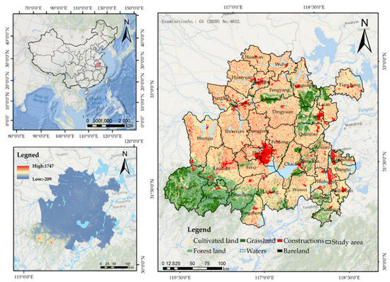
Figure 1.
Topography and land-use types in the study area.
2.2. Materials
The data used in this study mainly include land-use data and NDVI data in the study area, which come from the Resource and Environment Science Data Center of the Chinese Academy of Sciences (https://www.resdc.cn/, access on 20 July 2021); the Digital Elevation Model (DEM) was obtained from the Geospatial Data Cloud website (http://www.gscloud.cn/, accessed on 20 July 2021) with a raster size of 90 m; the meteorological data in the study area come from the “Anhui Surface Climate Data Monthly Value Data Set” (http://data.cma.cn/, accessed on 20 July 2021); the actual evapotranspiration data of the Hefei metropolitan area come from the National Qinghai–Tibet Plateau Science Data Center, and the data have a 30 m precision through ArcGIS Kriging interpolation (http://data.tpdc.ac.cn/zh-hans/, accessed on 19 July 2021); the soil data come from the Chinese soil dataset (1:1 million) (http://vdb3.soil.csdb.cn/, accessed on 19 July 2021); the NPP-VIIRS night light data come from the National Oceanic and Atmospheric Administration (https://www.noaa.gov/, accessed on 19 July 2021); the national terrestrial ecosystem classification comes from the China Terrestrial Ecosystem Database (https://www.ecosystem.csdb.cn/index.jsp, accessed on 19 July 2021); the relevant planning documents and other data of the study area come from government departments. Based on the ArcGIS platform (https://developers.arcgis.com/, accessed on 19 July 2021), the coordinate system of all spatial data is unified as Albers Conic Equal Area and resampled into a 30 m × 30 m grid unit size for subsequent operations (Table 1).

Table 1.
Basic introduction of research data.
3. Methods
Focusing on studying the characteristics of regional ecosystems and the requirements of regional high-quality development, this article constructs the ecological security pattern of the Hefei Metropolitan Area based on the research method of “source identification-corridor construction”. The ecological importance of the study area from three aspects—the importance of ecosystem services, ecological sensitivity, and landscape connectivity—was evaluated, and the natural breakpoint classification method was used to divide it into five categories, including extremely unimportant, unimportant, generally important, very important, and extremely important. The important and extremely important ecological land of the study area was extracted, and the cumulative proportion of different numbers of ecological land patches to the total ecological land area was used to initially screen and eliminate fragmented patches to select ecological sources. Then, ecological corridors were identified based on the least cumulative resistance model, using the minimum cumulative expansion resistance of the source and the minimum accumulation of the town. The difference in expansion resistance was divided into an ecological buffer zone, ecological transition zone, and development and construction zone; in view of the post-construction ecological security pattern, the construction strategies for the ecological source area, ecological corridor, and ecological buffer zone were proposed (Figure 2).
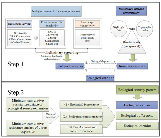
Figure 2.
Technology roadmap.
3.1. Identification of Ecological Sources
3.1.1. The Importance of Ecosystem Services
Ecosystem services refer to all the benefits that mankind obtains directly or indirectly from the ecosystem and are the basis for mankind’s survival and development. According to the characteristics of the study area’s ecosystem and reference-related research [3,18,19,20,21], four types of ecosystem service functions, including biodiversity, soil conservation, carbon fixation, and water conservation, were selected as important for the evaluation of the study area’s ecosystem services in this article. The study area is mainly responsible for soil conservation and water conservation services in the Yangtze River Delta, while habitat support and carbon storage services are relatively less important, so the four types of ecosystem services were normalized and assigned weight values of 0.3, 0.3, 0.2, and 0.2, respectively [22,23]. Through GIS spatial overlay analysis, the importance of ecosystem services in the study area was comprehensively evaluated, and the natural breakpoint classification method was used to divide it into three levels: high, medium, and low. The specific evaluation method and calculation process are shown in Table 2.

Table 2.
Ecosystem service assessment method and calculation process.
3.1.2. Ecological Sensitivity
Ecological sensitivity refers to the degree of response of the ecosystem to disturbance from human activities and changes in the natural environment, indicating the degree of difficulty and possibility of regional ecological environmental problems [28]. Ecological sensitivity assessment mainly includes sensitivity to soil erosion and rocky desertification. Through ecological sensitivity evaluation, it is possible to screen out highly sensitive areas that are not easy to recover after being disturbed, thereby providing a goal orientation for the determination of ecological space based on the perspective of improving the internal stability of the ecosystem and providing a scientific basis for the prevention and governance of regional ecological environmental problems.
The geological structure of the Hefei Metropolitan Area is complex. Geological disasters in mountainous areas such as landslides, collapses, ground subsidence, ground cracks, mudslides, and floods occur from time to time, which seriously affect the productivity and life of the people in the region. Salinization and desertification in the territory are not considered in this study due to the low degree of rocky desertification in the Hefei Metropolitan Area. The main consideration is the sensitivity of geological hazard risk and soil erosion sensitivity, of which geological hazard risk is general and elevation, slope, vegetation coverage, and land types are more closely related, which is estimated to represent the sensitivity evaluation of geological disasters. The ecological sensitivity evaluation of the study area was obtained after the evaluation indices were spatially superimposed on the GIS platform. The selection of main indicators and weight refer to related research [10,22,23,24], as shown in Table 3.

Table 3.
Classification and weight of ecological sensitivity evaluation factors.
3.1.3. Landscape Connectivity
Landscape connectivity refers to the degree of convenience or hindrance of the landscape to the ecological flow and is an important indicator to measure the ecological process of the landscape [25]. Maintaining good connectivity is one of the key factors to protect biodiversity and maintain the stability and integrity of the ecosystem [26]. The probability of connectivity (PC) can not only reflect the connectivity of the landscape but can also calculate the important value of each patch of the landscape to the connectivity of the landscape. It is currently widely used in landscape planning, and it spreads directly between the two habitat nodes. The possibility of defining connectivity was used as a basis for evaluating the intensity, frequency, or flexibility of the direct migration of the research species [29]. The calculation formula of the PC index is:
where is the total number of habitat nodes in the landscape; and are the areas of patch and patch , respectively; is the total area of the study area; and is all paths between patch and patch . The maximum value of the final connectivity is as follows:
where PC is the possible connectivity index of the landscape as a whole when all patches exist, and is the possible connectivity index value of the landscape composed of the remaining patches after the patch i is removed. The higher the value of , the higher the importance of the patch in landscape connectivity, and the more obvious the core position of patch i in the landscape. This paper uses ArcGIS 10.2 software plug-in modules Cone for Inputs for ArcGIS 10.2 and Cone for Seminude 2.5.8 to calculate the connectivity of ecological sources.
3.2. Minimum Cumulative Resistance Surface Construction
The difficulty of species movement in different habitats in horizontal space is mainly affected by land cover and human activities. According to the research of existing scholars, the reciprocal habitat quality was used to construct the resistance surface of the Hefei Metropolitan Area, and the night light data, impervious surfaces, and topographic index were used as correction factors [30,31]. Night light data and impervious surfaces can indicate the intensity of human activities, and the topographical position was used to analyze the impact of terrain gradients on land use [32,33,34]. Considering that the value may appear to be zero, the data were processed into non-zero values and do not affect the actual resistance surface composition (Figure 3):
where is the corrected resistance value of each grid in the study area, is the initial resistance value constructed based on the reciprocal of the habitat quality, is the normalized night light index, and is the return value. In the Yihua terrain index, and represent the elevation value of any grid and the average elevation value of the study area; and represent the slope value of any grid and the average slope value of the study area.
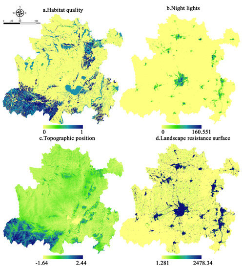
Figure 3.
Landscape resistance surface and its constituent factors.
3.3. Ecological Security Pattern Construction
According to previous studies [2,6,35,36] and the requirements of regional development, the construction of an ecological security pattern mainly includes establishing ecological sources and restricting construction and development in this area, establishing ecological corridors to promote species exchanges, etc. The ecological process is carried out in an orderly manner, and buffer zones are established to reduce the interference of human activities in the core area. Therefore, this study constructs a regional ecological security pattern from three aspects: ecological source, buffer zone, and potential ecological corridor:
- (1)
- Ecological source. The source area is the core area of ecological protection. This study extracts the ecologically important and extremely important ecological land in the study area and removes the small patches that have little impact on the ecosystem service function to obtain the ecological source area of the study area.
- (2)
- Buffer zone. Based on the minimum cumulative resistance model, the minimum cumulative resistance of the ecological source and urban land is calculated and normalized, and then the difference between the two is calculated, and the area outside the ecological source is partitioned through the mutation detection method [37]. The buffer zone is an area with low cumulative resistance around the ecological source area. It is used to protect the ecological process and natural succession of the core area, reduce the impact of human disturbance of the external landscape, and propose corresponding planning strategies for the ecological buffer zone.
- (3)
- Ecological corridor. The potential ecological corridor is the lowest cumulative resistance valley line between ecological sources. Based on the ecological source and the landscape resistance surface, the Linkage Mapper tool can be used to calculate the minimum cumulative cost distance path, thereby determining the spatial location of the ecological corridor and identifying important corridors.
4. Results
4.1. Results of Ecological Land Identification
- (1)
- The importance of ecosystem services
In terms of the importance of ecosystem services (Figure 4a), high importance is mainly distributed in the Dabie Mountain area in western Anhui and around Chaohu Lake. The land area is 18,270.48 km2, accounting for 28.80% of the total study area. The hilly areas south of Hefei and east of Chaohu Lake are the habitats of most biological species. In addition, some woodlands and waters are scattered around the Huai River in northern Anhui and the Badong Mountain in Huainan, which also have important ecosystem service functions.
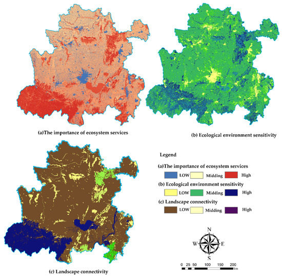
Figure 4.
The spatial pattern of the importance of ecosystem services, ecological sensitivity, and landscape connectivity in the Hefei metropolitan area.
- (2)
- Ecological sensitivity
In terms of ecological sensitivity (Figure 4b), it is mainly distributed around the Dabie Mountains and the interlaced zone of mountainous plains in western Anhui. The land area is 11,499.86 km2, accounting for 18.13% of the total area of the study area. Due to the interference of human activities, woodland and grassland close to urban construction land are highly sensitive and vulnerable to damage.
- (3)
- Landscape connectivity
The landscape connectivity in the study area (Figure 4c) is mainly vegetation enrichment areas or water areas. The high-connectivity patches in the area are Dabie Mountain, Chaohu Lake, and the Yangtze River in western Anhui. They have extremely important ecological service functions in the area and are regulating areas. The climate is an important ecological source for maintaining regional ecological activities.
4.2. Construction of Ecological Security Pattern
4.2.1. Ecological Source
The importance of ecosystem services, ecological sensitivity, and landscape connectivity are superimposed to obtain the ecological importance grade evaluation result (Figure 5a), which is divided into three grades of low, medium, and high through the natural breakpoint classification method, and the high-grade land is extracted as the study area’s ecological land (Figure 5b). Considering the limited contribution of patches to ecological services, the proportion of the contribution of patches to the total area of ecological land is used to screen the ecological land, and the fragmented ecological land patches are removed to obtain the final ecological source (Figure 5c). After this exclusion, the area of ecological sources accounted for 85.6% of the total ecological land area, specifically 15,538.74 km2. Large-scale ecological sources are mainly distributed around the Dabie Mountains and Chaohu Basin in western Anhui. The overall ecological sources in northern Anhui are relatively fragmented. This is related to the mainland composition of northern Anhui as cultivated land, woodland, grassland, etc., are divided into fine patches.
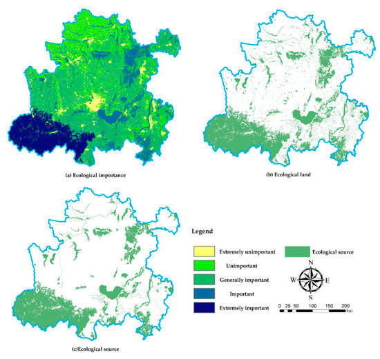
Figure 5.
Results of ecological source identification of Hefei metropolitan area.
4.2.2. Ecological Buffer Zone
The calculation results of the minimum cumulative resistance surface for the expansion of the ecological source are shown in Figure 6. Using the mutation-detection method, three areas other than the ecological source and construction land are obtained (Figure 6c). Among them, the area of low cumulative resistance surrounding the ecological source is the ecological buffer zone, with an area of 21,702.2 km2, accounting for 21.8% of the area. This area is a landscape space around the source that is easier for species to use and plays an important role in maintaining the connectivity of the ecological source and protecting the source from interference from human activities. The area outside the ecological buffer zone has a relatively high cumulative resistance value, and its sensitivity to human activities is low. It is not suitable for development as an ecological source and can be designated as an ecological transition zone and a development and construction zone. The area of the ecological transition zone is 19,015.2 km2, and the area accounts for 39.7%. It can be used as a marginal area for source protection and is suitable for development and utilization with a low intensity of interference activities. The area of development and construction is 18,435.5 km2, accounting for 38.5% of the area, which can be used as the urban development and construction area.
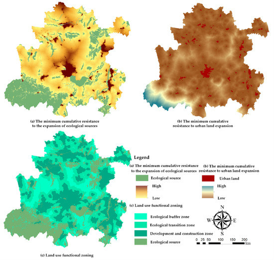
Figure 6.
Minimum cumulative resistance surface and land function zoning map.
4.2.3. Ecological Corridor
Based on the Linkage Mapper tool, we calculated the minimum cumulative cost distance path, connected the ecological sources, built ecological corridors, and obtained 167 ecological corridors. Combining with the actual situation of the study area and referring to relevant research, the corridor width is set to 1 km, and the total length of the ecological corridor is 2816.89 km. As shown in Table 4, the total area of ecological corridors is 2479.06 km2, of which the area of important corridors is 808.45 km2. In the landscape composition of the corridor, arable land accounts for the largest proportion of 70.06%, mainly because arable land is the largest landscape resource in the region; water accounts for 10.02%. Generally speaking, water areas will hinder the migration of animals to some extent, but research on the water system in the region is relatively fragmented and cannot divide habitats, and many scattered water bodies also provide short-term habitats for animal migration to a certain extent. Forest land accounts for 8.24%, which is an important biological habitat and an important node in the process of biological migration. Urban construction land, villages, and other construction land are major hindrances to species migration, accounting for 7.94%.

Table 4.
Landscape composition of an ecological corridor.
Among the potential corridors, some corridors have a high utilization rate during species migration or ecological processes and have a key role, while other ecological corridors may not have frequent ecological activities and play a relatively small role. Through the ArcGIS 10.2 nuclear density analysis tool, quantify the utilization efficiency of ecological corridors in different spatial locations, thereby identifying important corridors. The nuclear density analysis results are shown in Figure 7. Among them, large woodland patches around Dabie Mountain in western Anhui and hilly areas in the east have become important places for animal habitation and migration, which play a key role in connecting.
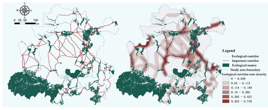
Figure 7.
Ecological corridor map of Hefei Metropolitan Area.
4.2.4. Ecological Security Pattern
Ecological source areas and ecological corridors are the core part of building an ecological security pattern. The buffer zone can be used as a reserve resource for the expansion of ecological sources and can be transformed into ecological sources under necessary conditions. Furthermore, it can also serve as an ecological source and human activities. The role of interference isolation is to protect the stability of the regional ecological process.
The construction of the ecological security pattern of the Hefei Metropolitan Area is shown in Figure 8. On the whole, relying on the natural environment in the area, the study area has formed an ecological pattern with Dabie Mountains, Chaohu Lake, Huai River, and Yangtze River as the core ecological supply areas. Dabie Mountain is the core source of important ecosystem services in Anhui Province and even in the country, and it is an important node for maintaining regional ecosystem services.
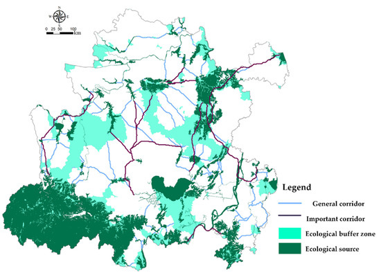
Figure 8.
Construction of ecological security pattern of Hefei Metropolitan Area.
As an important water supply area and water and soil conservation area in the middle reaches of the Huai River and the lower reaches of the Yangtze River, Dabie Mountain is currently highly sensitive to soil erosion, and the mountain ecosystem is degraded, which has increased the incidence of floods in the middle and lower reaches of the Huai River. Therefore, policy guarantees should be put forward for the Dabie Mountains, an ecological compensation mechanism should be established, and a comprehensive benefit evaluation index system should be established to ensure the coordinated advancement of the ecological environment and economic development. These policies and measures are based on the harmonious relationship between man and nature, insisting on natural evolution as the mainstay, and the process of natural succession is normalized to curb further degradation of the ecosystem through a series of measures to accelerate the restoration of surface vegetation coverage, increase the protection of nature, reduce human intervention in prohibited and restricted areas, give play to the ecological self-reproduction and restoration capabilities, and achieve the improvement and promotion of the ecosystem [37,38].
For large water bodies such as the Yangtze River and the Huai River Basin, the implementation of the policy of retreat (fishing) to the lake should be promoted to protect the water surface of the lake and improve the fluidity of the river and lake. The water body corridor contains three parts: the water area; shore water conservancy facilities, slope protection, and bank revetment; and riverbank greening. These are an important part of maintaining the normal operation of the ecological environment. Due to the development of beach areas, the narrowing of river channels, and other serious destruction of river corridors, the ecological functions of river corridors have been severely damaged. Therefore, it is recommended to address the problems of “river floodplain wetland ecological restoration belt”, “bank ecological recreation belt”, and “external ecological protection belt”. The construction of ecological corridors will focus on the construction of cultural, ecological, and water conservancy facilities to improve the living and leisure environment and the biodiversity of animal and plant habitats. Construction activities should be strictly restricted in the ecological buffer zone to ensure that the landscape pattern in the buffer zone evolves in a positive direction to increase ecological security. For example, afforestation forms a contiguous spatial pattern, connecting small water systems and large water systems in the area, forming a complete water grid, and creating space for short stays for biological migration. For the construction of ecological corridors, it is recommended to increase the number of forest and grass species and improve the forest quality and biodiversity. At the same time, the implementation of the policy of returning farmland to forests and grasslands on important corridors should be sped up; for potential corridors, measures should be taken by local conditions, both planned and implemented. The construction should be promoted step by step in a targeted manner.
5. Discussion
5.1. Conflict Land for Ecological Protection and Urban Expansion
In the process of rapid urbanization, the contradiction between ecological environmental protection and urban construction land expansion has become increasingly prominent [1]. Habitat patches are strongly affected by the surrounding land-use changes, becoming fragmented and islanded, seriously threatening regional biodiversity, and even becoming regionally high obstacles to quality development [37,38].
Using the current land-use map in the study area, the ecological source area, buffer zone, and urban construction land are spatially superimposed to identify conflicting land used for ecological protection and urban expansion, as shown in Figure 9. Among them, the area of conflict zone is 305.23 km2, accounting for 1.17% of the total area of the ecological source area and the ecological buffer zone. Affected by topographical restrictions, the urban construction areas of the Hefei Metropolitan Area are mainly distributed in flat areas. Urban built-up areas are expanded rapidly, and it is easier to invade ecological areas such as the Yangtze River, Huai River, Chaohu Lake, which are closely related with human activities. Therefore, it is necessary to arrange farmland or construct shelterbelts at the edge of ecological sources to reduce the interference caused by external land changes. Thanks to the state’s efforts to manage the surrounding ecosystems of Huai River and Chaohu in recent years, it is less affected by construction land. However, due to the superior geographical location, the frequent urban construction activities, and the early development period around the Yangtze River, it has become inherent. In fact, a large number of conflict areas have emerged from this. In the future construction process, water conservation areas should be divided, all construction activities within the scope should be prohibited, and linear natural fences should be formed in the peripheral facilities of the buffer zone, such as woodland and grassland, to maintain the safety of water resources and the habitation of aquatic species [38].
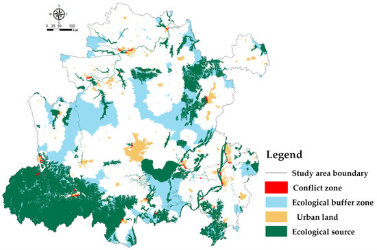
Figure 9.
Ecological protection of the Hefei Metropolitan Area and identification of urban expansion land.
5.2. Research Deficiency and Prospects
This research constructs a framework of “ecological importance ecological sensitivity–landscape connectivity” to identify important ecological sources; divides ecological buffer zones, ecological transition zones, and development and construction areas based on the minimum accumulation model; and identifies cities through spatial superposition of current land use, expansion of conflicting land, and proposed corresponding management and control strategies, but the construction of ecological security pattern is an extension of the core idea of landscape ecology “pattern-process”. Whether the current research results can produce the expected effect or not needs to be tested in practice. The width of the landscape ecological corridor directly affects its performance in maintaining ecological security. Different species have different requirements for the width of the corridor [39]. How to determine the width of the ecological corridor under different conditions is a key issue that needs to be discussed in the future. Whether the identified ecological source sites based on current data are reasonable has not been explored. Related studies have shown that climate change can lead to large changes in ecosystem services, for example, changes in rainfall can affect the spatial pattern of water content, which in turn can affect the evaluation results of overall system services. Therefore, in the future, we can try to explore the spatial pattern changes in ecological source sites in the long term.
6. Conclusions
Taking the Hefei Metropolitan Area as an example, this paper quantitatively evaluates the importance of ecosystem services, ecological sensitivity, and landscape connectivity in the study area to identify ecological sources by using night light data, impervious surface, and topographic level index correction. The landscape resistance surface is based on the least cumulative resistance model to delineate the buffer zone and identify the ecological corridor, thereby constructing the regional ecological security pattern and identifying the conflict area based on the current land use superimposed with the ecological source and buffer zone.
The research results show that the ecological source area of the Hefei Metropolitan Area is 15,538.74 km2, accounting for 24.5% of the total study area. It is mainly composed of the Dabie Mountains, the Yangtze River, the Huai River, and Chaohu Lake. The area of the ecological buffer zone, ecological transition zone, and development and construction zone account for 21.8%, 39.7%, and 38.5%, respectively. Among them, the ecological buffer zone serves as a protective barrier for the ecological source area, and therefore, development and construction activities should be restricted. The ecological transition zone should be constructed with low development intensity, and the development and construction zone can be carried out with greater development intensity. The total length of the ecological corridor is 2816.89 km. The mainland of the corridor is cultivated land, followed by water and woodland. The area of conflict of urban expansion is 305.23 km2 identified by superposition of the land use, accounting for 1.17% of the total area of the ecological source area and ecological buffer zone. Development guidance and planning control should be carried out for this area.
Author Contributions
Conceptualization, X.F., C.H. and Y.R.; methodology, X.F.; software, X.F.; validation, C.T., Y.Q. and Y.R.; formal analysis, X.F. and S.O.; investigation, H.S. and S.O.; resources, Y.R.; data curation, Y.R.; writing—original draft preparation, X.F.; writing—review and editing, X.F., J.H. and Y.Q.; visualization, X.F.; supervision, J.L.; project administration, X.F. and S.O.; funding acquisition, Y.R. and C.T. All authors have read and agreed to the published version of the manuscript.
Funding
This research was funded by the Natural Resources Science and Technology Program in Jiangsu Province (Project Numbers: 2021021) and CISPDR Corporation Open Innovation Fund Project: Research on watershed ecological conservation and restoration planning techniques from the perspective of ecosystem service supply and demand (Project Numbers: CX2021K01).
Data Availability Statement
Data sharing is not applicable to this article.
Acknowledgments
We would like to thank Horan Yu from Nanjing Forestry University and Xinchen Gu from Tianjin University, whose technical and methodological support greatly improved the quality of this paper.
Conflicts of Interest
The authors declare no conflict of interest.
References
- Wang, Y.; Jin, X.; Shen, C.; Bao, G.; Liu, J.; Zhou, Y. Establishment of an ecological security pattern in the eastern developed regions: A case study of the Sunan District. J. Acta Ecol. Sin. 2019, 39, 2298–2310. [Google Scholar]
- Yu, P.; Fennell, S.; Chen, Y.; Liu, H.; Xu, L.; Pan, J.; Bai, S.; Gu, S. Positive impacts of farmland fragmentation on agricultural production efficiency in qilu lake watershed: Implications for appropriate scale management. Land Use Policy 2022, 117, 106108. [Google Scholar] [CrossRef]
- Chen, X.; Peng, J.; Liu, Y.; Yang, Y.; Li, G. Constructing ecological security patterns in Yunfu city based on the framework of importance-sensitivity-connectivity. J. Geogr. Res. 2017, 36, 471–484. [Google Scholar]
- Yu, K. Landscape ecological security patterns in biological conservation. J. Acta Ecol. Sin. 1999, 1, 10–17. [Google Scholar]
- Ni, Q.; Ding, Z.; Hou, H.; Jia, N.; Wang, H. Ecological pattern recognition and protection based on circuit theory. J. Arid Land Resour. Environ. 2019, 33, 67–73. [Google Scholar]
- Dai, L.; Liu, Y.; Huang, K. Construction of an ecological security network for waterfront cities based on MCR model and DO index: A case study of Jiujiang city. J. Acta Geogr. Sin. 2020, 75, 2459–2474. [Google Scholar]
- Chen, D.; Lan, Z.; Li, W. Construction of land ecological security in Guangdong province from the perspective of ecological demand. J. Ecol. Rural Environ. 2019, 35, 826–835. [Google Scholar]
- Li, H.; Ma, T.; Wang, K.; Tan, M.; Qu, J. Construction of ecological security pattern in northern Peixian based on MCR and SPCA. J. Ecol. Rural Environ. 2020, 36, 1036–1045. [Google Scholar]
- Tan, H.; Zhang, J.; Zhou, X. Construction of ecological security patterns based on minimum cumulative resistancemodel in Nanjing City. J. Bull. Soil Water Conserv. 2020, 40, 282–288. [Google Scholar]
- Yu, C.; Liu, D.; Feng, R.; Tang, Q.; Guo, C. Construction of ecological security pattern in Northeast China based on MCR model. J. Acta Ecol. Sin. 2021, 41, 290–301. [Google Scholar]
- Yuan, S.; Chen, J.; Gong, Q.; Yin, X.; Liu, T.; Wang, J.; Huang, G.; Luo, X. An ecological security pattern construction method based on Apache Spark machine learning. J. Acta Ecol. Sin. 2019, 39, 4793–4805. [Google Scholar]
- Ding, Y.; Zhang, L.; Zeng, X. The Construction of an ecological function network and its application in the greater bay area, China. J. Ecol. Rural Environ. 2019, 35, 573–581. [Google Scholar]
- Liu, G. Formation and evolution mechanism of ecological security pattern in Southwest China. J. Acta Ecol. Sin. 2016, 36, 7088–7091. [Google Scholar]
- Lu, H.; Yan, Y.; Zhao, C.; Wu, G. Framework of constructing multi-scale ecological security pattern in Xiongan New Area. J. Acta Ecol. Sin. 2020, 40, 7105–7112. [Google Scholar]
- Geng, R.; Yin, P.; Ma, Q. Simulation research for ecological security pattern construction based on improvement of water and air quality in Gui’an New Area. J. China Environ. Sci. 2018, 38, 1990–2000. [Google Scholar]
- Cong, D.; Zhao, S.; Yu, T.; Chen, C.; Wang, X. Urban growth boundary delimitation method integrating comprehensive ecological security pattern and urban expansion simulation—A case study of planning areas in Tianshui city (2015–2030). J. Nat. Resour. 2018, 33, 14–26. [Google Scholar]
- Wang, H.; Li, H.; Xie, M.; Xu, M.; Li, S.; Bai, Z. Construction of ecological security pattern for systematic restoration of industrial and mining land in resource-based cities. J. Nat. Resour. 2020, 35, 162–173. [Google Scholar]
- Qu, B.; Li, X. Study on ecological safety pattern of Haitan island based on ecological service function. J. Fujian Norm. Univ. 2019, 35, 28–36, 45. [Google Scholar]
- Wang, Q.; Fu, M.; Wei, L.; Han, Y.; Shi, N.; Li, J.; Quan, Z. Urban ecological security pattern based on source-sink landscape theory and MCR model: A case study of Ningguo City, Anhui Province. J. Acta Sci. Circumstantiate 2016, 36, 4546–4554. [Google Scholar]
- Tang, F.; Wang, L.; Zhang, P.; Fu, M.C. Construction of county-level ecological security pattern based on ecological protection red line and network in China. J. Trans. Chin. Soc. Agric. Eng. 2020, 36, 263–272. [Google Scholar]
- Du, Y.; Hu, Y.; Yang, Y.; Peng, J. Building ecological security patterns in southwestern mountainous areas based on ecological importance and ecological sensitivity: A case study of Dali Bai Autonomous Prefecture, Yunnan Province. J. Acta Ecol. Sin. 2017, 37, 8241–8253. [Google Scholar]
- Yang, Q.; Li, T.; Wang, Z.; Lin, L.; Peng, Q.; Lin, B.; Zheng, C. Integrated assessment on ecological sensitivity for Shennongjia National Park. J. Hubei Univ. 2017, 39, 455–461. [Google Scholar]
- Huang, X.; Cao, X.; Zhang, M. Construction of landscape ecological security pattern of shengli coalfield in Inner Mongolia based on the minimum cumulative resistance model. J. Ecol. Rural Environ. 2019, 35, 55–62. [Google Scholar]
- Wang, X.; Chen, T.; Feng, Z.; Wu, K.; Lin, Q. Construction of ecological security pattern based on boundary analysis: A case study on Jiangsu Province. J. Acta Ecol. Sin. 2020, 40, 3375–3384. [Google Scholar]
- Pan, F.; Tian, C.; Shao, F.; Zhou, W.; Chen, F. Evaluation of ecological sensitivity in Karamay, Xinjiang, Northwest China. J. Geogr. Sci. 2012, 22, 329–345. [Google Scholar] [CrossRef]
- Liu, L.; Liu, X. Landscape pattern and ecosystem service function of Loess Plateau during 1990–2000. J. Arid Land Resour. Environ. 2011, 25, 8–13. [Google Scholar]
- Zheng, Q.; Zeng, J.; Luo, J.; Cui, J.; Sun, X. Spatial structure and space governance of ecological network in Wuhan city. J. Econ. Geogr. 2018, 38, 191–199. [Google Scholar]
- Ouyang, Z.; Wang, X.; Miao, H. China‘s eco-environmental sensitivity and its spatial heterogeneity. J. Acta Ecol. Sin. 2000, 1, 10–13. [Google Scholar]
- Li, Y. The dynamic changes of ecological security in northern China. J. Geogr. Res. 2008, 27, 1150–1160. [Google Scholar]
- Konstantinos, K.; Vlassios, H. Soil Erosion: Rainfall Erosivity and Risk Assessmen; IntechOpen: London, UK, 2019. [Google Scholar]
- Wu, Q.; Wang, M. A framework for risk assessment on soil erosion by water using an integrated and systematic approach. J. Hydrol. 2007, 337, 11–21. [Google Scholar] [CrossRef]
- Guan, X.; Wei, H.; Lu, S.; Dai, Q.; Su, H. Assessment on the urbanization strategy in China: Achievements, challenges, and reflections. J. Habitat Int. 2018, 71, 97–109. [Google Scholar] [CrossRef]
- Pham, V.M.; Van Nghiem, S.; Bui, Q.T.; Pham, T.M.; Van Pham, C. Quantitative assessment of urbanization and impacts in the complex of Huế Monuments, Vietnam. J. Appl. Geogr. 2019, 112, 102096. [Google Scholar] [CrossRef]
- Kookana, R.S.; Drechsel, P.; Jamwal, P.; Vanderzalm, J. Urbanization and emerging economies: Issues and potential solutions for water and food security. J. Sci. Total Environ. 2020, 732, 139057. [Google Scholar] [CrossRef] [PubMed]
- Wu, J.; Ma, H.; Peng, J. Improving urban ecological security pattern based on functional nodes-key corridors: A case study of Shenzhen City. J. Prog. Geogr. 2018, 37, 1663–1671. [Google Scholar]
- Hou, P.; Yang, M.; Zhai, J.; Liu, X.; Wan, H.; Li, J.; Cai, M.; Liu, H. Discussion about natural reserve and construction of national ecological security pattern. J. Geogr. Res. 2017, 36, 420–428. [Google Scholar]
- Yang, S.; Zou, C.; Shen, W.; Shen, R.; Xu, D. Construction of ecological security patterns based on ecological red line: A case study of Jiangxi Province. J. Chin. J. Ecol. 2016, 35, 250–258. [Google Scholar]
- Yu, H.; Gu, X.; Liu, G.; Fan, X.; Zhao, Q.; Zhang, Q. Construction of regional ecological security patterns based on multi-criteria decision making and circuit theory. Remote Sens. 2022, 14, 527. [Google Scholar] [CrossRef]
- Zhu, Q.; Yu, K.-J.; Li, D.-H. The width of ecological corridor in landscape planning. Acta Ecol. Sin. 2005, 25, 2406–2412. [Google Scholar]
Publisher’s Note: MDPI stays neutral with regard to jurisdictional claims in published maps and institutional affiliations. |
© 2022 by the authors. Licensee MDPI, Basel, Switzerland. This article is an open access article distributed under the terms and conditions of the Creative Commons Attribution (CC BY) license (https://creativecommons.org/licenses/by/4.0/).