
Terrain Proxy-Based Site Classification for Seismic Zonation in North Korea within a Geospatial Data-Driven Workflow


Abstract
1. Introduction
2. Method and Data
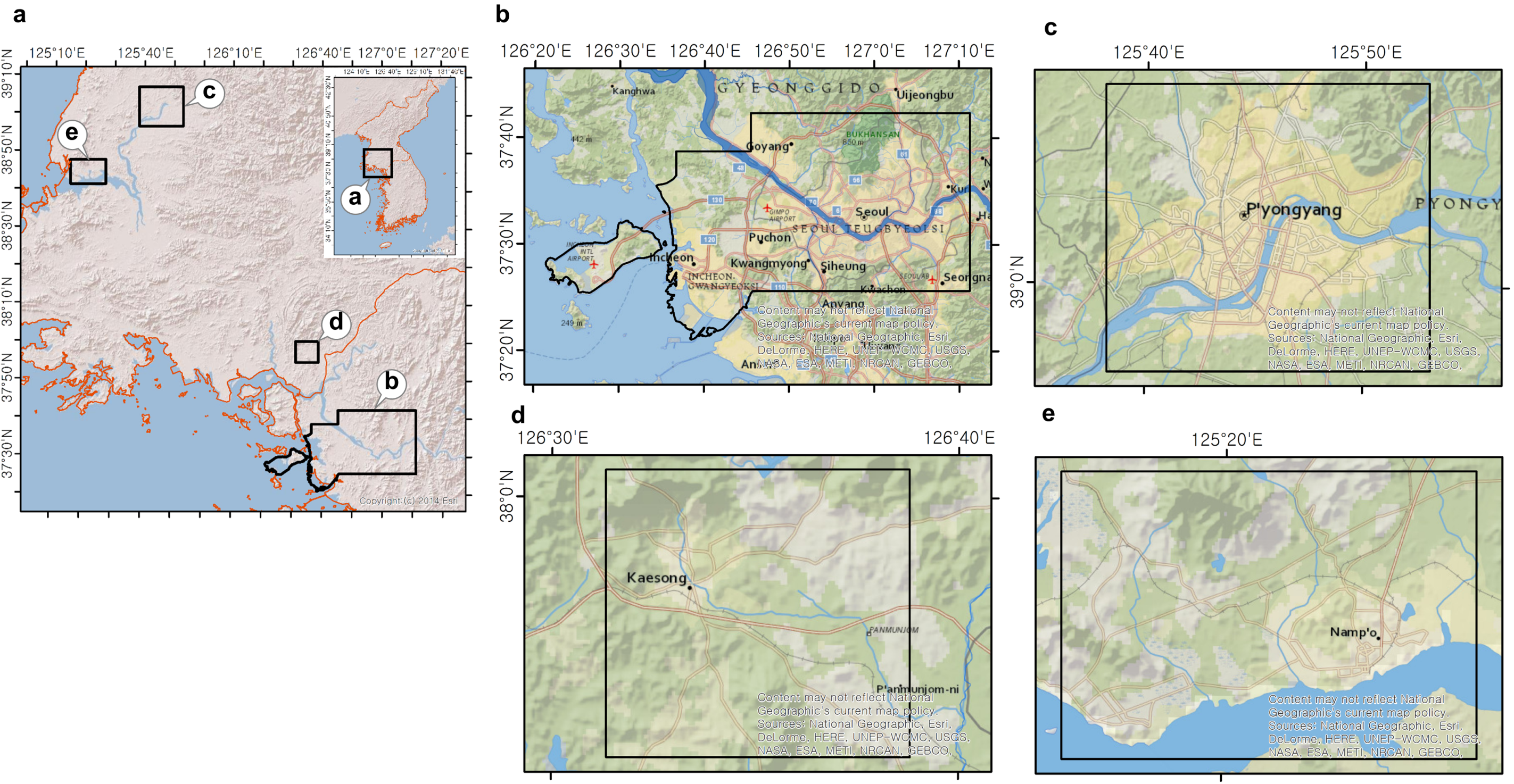
2.1. Study Area
2.2. Digital Terrain Model
2.3. Geotechnical Datasets
2.4. Methodology
2.4.1. Topographic Position Index and Land Formation
2.4.2. Geospatial Interpolation for Surficial and Subsurface Grid Building
2.4.3. Multivariate Site Response Parameters and Classification System
2.4.4. Multivariate Regression
3. Results
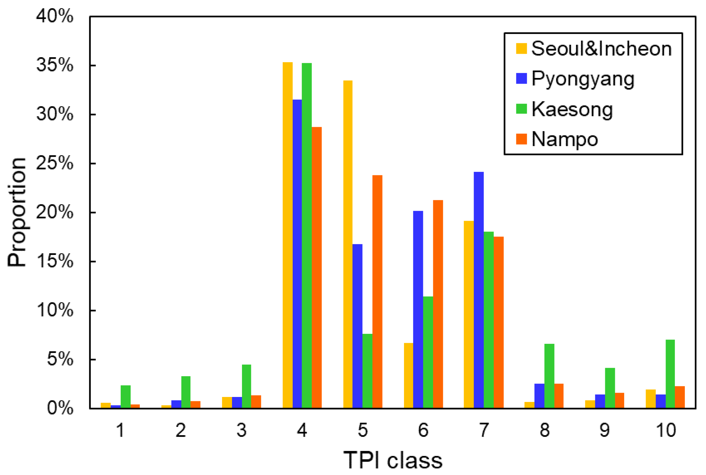
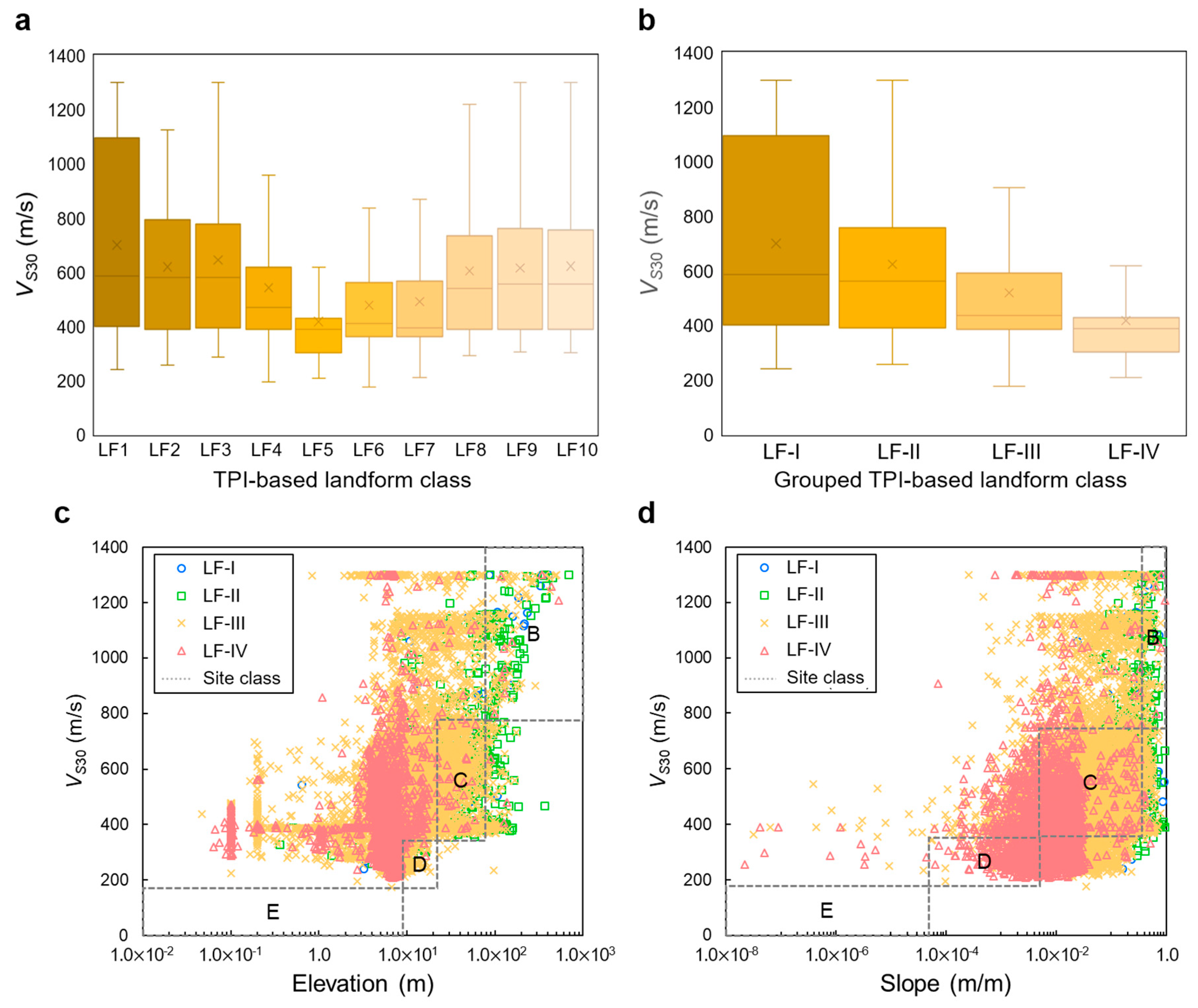
3.1. Topographic Position Index-Based Classification of Landforms
3.2. Geospatial Grids Assigned with VS30 and in Test Area
3.3. Adaptation of Terrain Proxy-Based Site Class
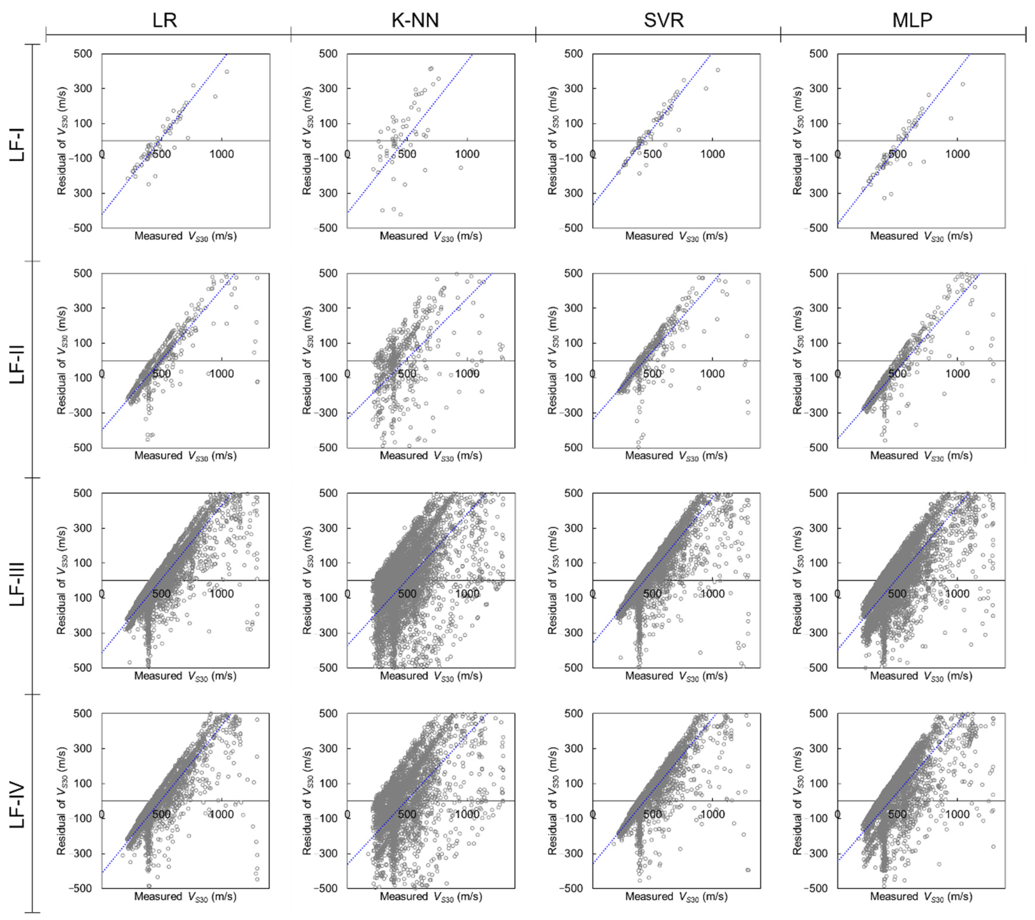
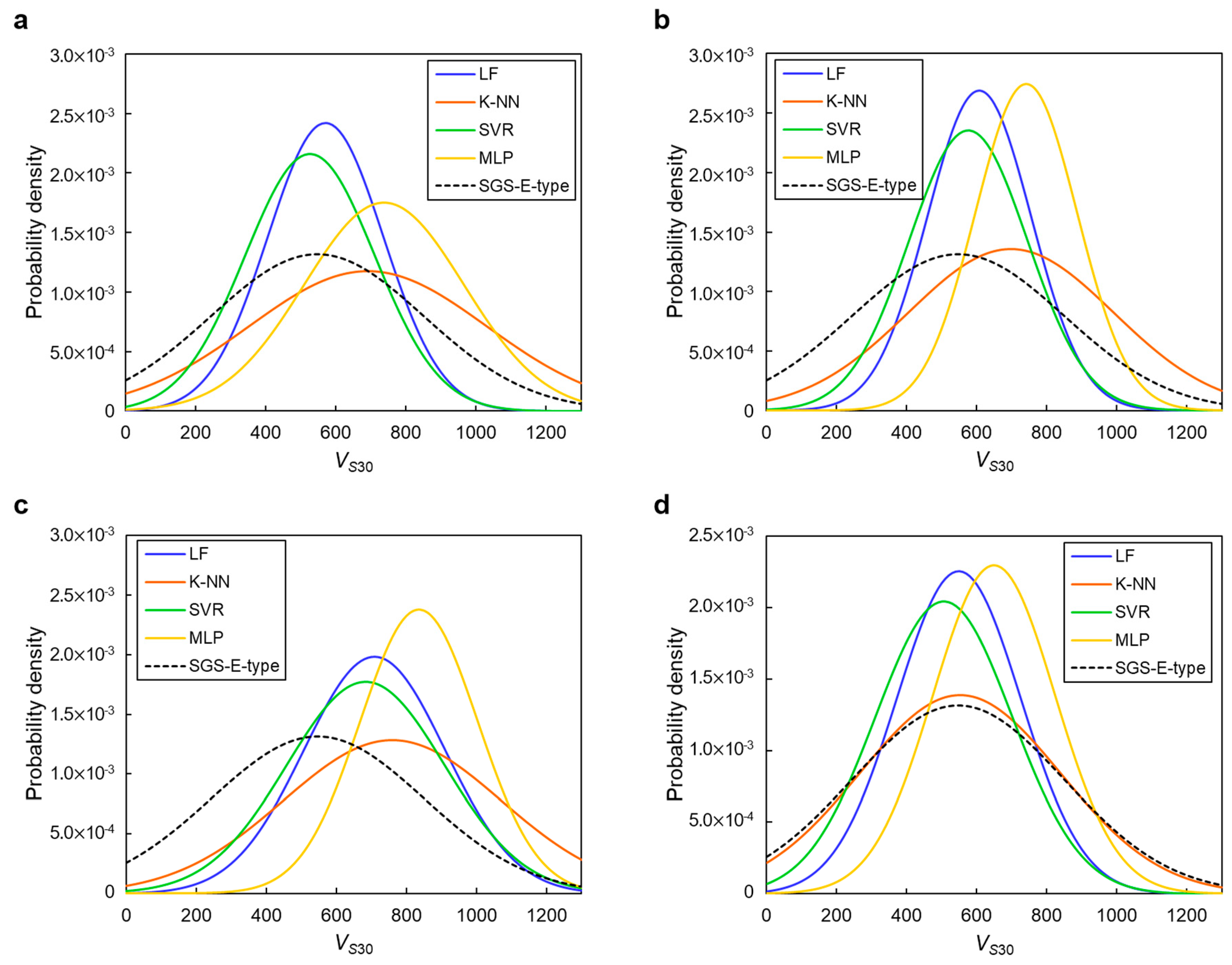
3.4. Multivariate Regression Model for Terrain Proxy-Based VS30 Classification
3.5. VS30 Mapping in the Test Area, North Korea
4. Discussion
5. Conclusions
Author Contributions
Funding
Institutional Review Board Statement
Informed Consent Statement
Data Availability Statement
Acknowledgments
Conflicts of Interest
References
- Lee, S.J.; Rhie, J.; Kim, S.; Kang, T.S.; Cho, C.S. 1-D velocity model for the North Korean Peninsula from Rayleigh wave dispersion of ambient noise cross-correlations. J. Seismol. 2020, 24, 121–131. [Google Scholar] [CrossRef]
- Walter, W.R.; Dodge, D.A.; Ichinose, G.; Myers, S.C.; Pasyanos, M.E.; Ford, S.R. Body-wave methods of distinguishing between explosions, collapses, and earthquakes: Application to recent events in North Korea. Seismol. Res. Lett. 2018, 89, 2131–2138. [Google Scholar] [CrossRef]
- Zhai, M.; Zhang, X.H.; Zhang, Y.B.; Wu, F.Y.; Peng, P.; Li, Q.L.; Li, Z.; Guo, J.; Li, T.; Zhao, L.; et al. The geology of North Korea: An overview. Earth Sci. Rev. 2019, 194, 57–96. [Google Scholar] [CrossRef]
- Pedersen, H.A.; Campillo, M.; Sánchez-Sesma, F.J. Azimuth dependent wave amplification in alluvial valleys. Soil Dyn. Earthq. Eng. 1995, 14, 289–300. [Google Scholar] [CrossRef]
- Theodulidis, N.; Bard, P.Y.; Archuleta, R.; Bouchon, M. Horizontal-to-vertical spectral ratio and geological conditions: The case of Garner Valley downhole array in southern California. Bull. Seismol. Soc. Am. 1996, 86, 306–319. [Google Scholar]
- Castellaro, S.; Mulargia, F.; Rossi, P.L. VS30: Proxy for seismic amplification? Seismol. Res. Lett. 2008, 79, 540–543. [Google Scholar] [CrossRef]
- Wald, L.A.; Mori, J. Evaluation of methods for estimating linear site-response amplifications in the Los Angeles region. Bull. Seismol. Soc. Am. 2000, 90, S32–S42. [Google Scholar] [CrossRef]
- Mucciarelli, M.; Gallipoli, M.R. Comparison between VS30 and Other Estimates of Site Amplification in Italy. In Proceedings of the First European Conference on Earthquake Engineering and Seismology, Geneva, Switzerland, 3–8 September 2006. [Google Scholar]
- Di Giacomo, D.; Gallipoli, M.R.; Mucciarelli, M.; Parolai, S.; Richwalski, S.M. Analysis and modeling of HVSR in the presence of a velocity tnversion: The case of Venosa, Italy. Bull. Seismol. Soc. Am. 2005, 95, 2364–2372. [Google Scholar] [CrossRef]
- Ahdi, S.K.; Stewart, J.P.; Ancheta, T.D.; Kwak, D.Y.; Mitra, D. Development of VS profile database and proxy-based models for VS30 prediction in the Pacific Northwest region of North America. Bull. Seismol. Soc. Am. 2017, 107, 1781–1801. [Google Scholar]
- Karimzadeh, S.; Feizizadeh, B.; Matsuoka, M. DEM-Based VS30 map and terrain surface classification in nationwide scale—A case study in Iran. ISPRS. Int. J. Geo Inf. 2019, 8, 537. [Google Scholar] [CrossRef]
- Wald, D.J.; Allen, T.I. Topographic slope as a oroxy for seismic site conditions and amplification. Bull. Seismol. Soc. Am. 2007, 97, 1379–1395. [Google Scholar] [CrossRef]
- Allen, T.I.; Wald, D.J. On the use of high-resolution topographic data as a proxy for seismic site conditions (VS30). Bull. Seismol. Soc. Am. 2009, 99, 935–943. [Google Scholar] [CrossRef]
- Iwahashi, J.; Pike, R.J. Automated classifications of topography from DEMs by an unsupervised nested-means algorithm and a three-part geometric signature. Geomorphology 2007, 86, 409–440. [Google Scholar] [CrossRef]
- Hartzell, S.; Carver, D.; Williams, R.A. Site response, shallow shear-wave velocity, and damage in Los Gatos, California, from the 1989 Loma Prieta earthquake. Bull. Seismol. Soc. Am. 2001, 91, 468–478. [Google Scholar] [CrossRef]
- Frankel, A.D.; Carver, D.L.; Williams, R.A. Nonlinear and linear site response and basin effects in Seattle for the M 6.8 Nisqually, Washington, earthquake. Bull. Seismol. Soc. Am. 2002, 92, 2090–2109. [Google Scholar] [CrossRef]
- McGaughey, W.J. Data-Driven Geotechnical Hazard Assessment: Practice and Pitfalls. In Proceedings of the First International Conference on Mining Geomechanical Risk, Australian Centre for Geomechanics, Perth, Australian, 9–11 April 2019; pp. 219–232. [Google Scholar]
- Mignan, A.; Scolobig, A.; Sauron, A. Using reasoned imagination to learn about cascading hazards: A pilot study. Disaster Prev. Manag. 2016, 25, 329–344. [Google Scholar] [CrossRef]
- Taghizadeh-Mehrjardi, R.; Emadi, M.; Cherati, A.; Heung, B.; Mosavi, A.; Scholten, T. Bio-inspired hybridization of artificial neural networks: An application for mapping the spatial distribution of soil texture fractions. Remote Sens. 2021, 13, 1025. [Google Scholar] [CrossRef]
- Raiyani, K.; Gonçalves, T.; Rato, L.; Salgueiro, P.; Marques da Silva, J.R. Sentinel-2 image scene classification: A comparison between Sen2Cor and a machine learning approach. Remote Sens. 2021, 13, 300. [Google Scholar] [CrossRef]
- Razavi-Termeh, S.V.; Sadeghi-Niaraki, A.; Choi, S.M. Ubiquitous GIS-based forest fire susceptibility mapping using artificial intelligence methods. Remote Sens. 2020, 12, 1689. [Google Scholar] [CrossRef]
- Zhao, Z.; Chow, T.L.; Rees, H.W.; Yang, Q.; Xing, Z.; Meng, F.R. Predict soil texture distributions using an artificial neural network model. Comput. Electron. Agric. 2009, 65, 36–48. [Google Scholar] [CrossRef]
- Song, X.D.; Liu, F.; Zhang, G.L.; Li, D.C.; Zhao, Y.G. Estimation of soil texture at a regional scale using local soil-landscape models. Soil Sci. 2016, 181, 435–445. [Google Scholar] [CrossRef]
- Gholami, H.; Mohammadifar, A.; Bui, D.T.; Collins, A.L. Mapping wind erosion hazard with regression-based machine learning algorithms. Sci. Rep. 2000, 10, 1–16. [Google Scholar]
- Okada, G.; Moya, L.; Mas, E.; Koshimura, S. The Potential Role of News Media to Construct a Machine Learning Based Damage Mapping Framework. Remote Sens. 2021, 13, 1401. [Google Scholar] [CrossRef]
- Chousianitis, K.; Del Gaudio, V.; Sabatakakis, N.; Kavoura, K.; Drakatos, G.; Bathrellos, G.D.; Skilodimou, H.D. Assessment of Earthquake-Induced Landslide Hazard in Greece: From Arias Intensity to Spatial Distribution of Slope Resistance Demand Assessment of Earthquake-Induced Landslide Hazard in Greece. Bull. Seismol. Soc. Am. 2016, 106, 174–188. [Google Scholar] [CrossRef]
- Schäfer, A.M.; Wenzel, F. Global megathrust earthquake hazard—maximum magnitude assessment using multi-variate machine learning. Front. Earth Sci. 2019, 7, 136. [Google Scholar] [CrossRef]
- Gitis, V.G.; Derendyaev, A.B. Machine learning methods for seismic hazards forecast. Geosciences 2019, 9, 308. [Google Scholar] [CrossRef]
- Sun, C.G.; Kim, D.S.; Chung, C.K. Geologic site conditions and site coefficients for estimating earthquake ground motions in the inland areas of Korea. Eng. Geol. 2005, 81, 446–469. [Google Scholar] [CrossRef]
- Zhai, M.; Zhu, X.; Zhou, Y.; Zhao, L.; Zhou, L. Continental crustal evolution and synchronous metallogeny through time in the North China Craton. J. Asian Earth Sci. 2020, 194, 104169. [Google Scholar] [CrossRef]
- Choi, B.Y.; Yun, S.T.; Yu, S.Y.; Lee, P.K.; Park, S.S.; Chae, G.T.; Mayer, B. Hydrochemistry of urban groundwater in Seoul, South Korea: Effects of land-use and pollutant recharge. Environ. Geol. 2005, 48, 979–990. [Google Scholar] [CrossRef]
- Palka, E.J.; Galgano, F.A. North Korea: A Geographical Analysis; United States Military Academy: New York, NY, USA, 2003. [Google Scholar]
- Doucette, J.; Lee, S.O. Experimental Territoriality: Assembling the Kaesong industrial complex in North Korea. Pol. Geogr. 2015, 47, 53–63. [Google Scholar] [CrossRef]
- Jo, J.C.; Ducruet, C. Maritime Trade and Port Evolution in a Socialist Developing Country: Nampo, Gateway of North Korea. Korea Spat. Plan. Rev. 2006, 51, 3–24. [Google Scholar]
- Stewart, J.P.; Klimis, N.; Savvaidis, A.; Theodoulidis, N.; Zargli, E.; Athanasopoulos, G.; Pelekis, P.; Mylonakis, G.; Margaris, B. Compilation of a local VS profile database and its application for inference of VS30 from geologic-and terrain-based proxies. Bull. Seismol. Soc. Am. 2014, 104, 2827–2841. [Google Scholar] [CrossRef]
- Vianello, A.; Cavalli, M.; Tarolli, P. LiDAR-derived slopes for headwater channel network analysis. Catena 2009, 76, 97–106. [Google Scholar] [CrossRef]
- Sun, C.G.; Kim, H.S. GIS-based regional assessment of seismic site effects considering the spatial uncertainty of site-specific geotechnical characteristics in coastal and inland urban areas. Geomat. Nat. Hazards Risk 2017, 8, 1592–1621. [Google Scholar] [CrossRef]
- Wair, B.R.; DeJong, J.T.; Shantz, T. Guidelines for Estimation of Shear Wave Velocity Profiles; Pacific Earthquake Engineering Research Center: Berkeley, CA, USA, 2012. [Google Scholar]
- Imai, T.; Tonouchi, K. Correlation of N-value with s-wave velocity and shear modulus. In Proceedings of the 2nd European Symposium on Penetration Testing, Amsterdam, The Netherlands, 24–27 May 1982; pp. 57–72. [Google Scholar]
- Ohsaki, Y.; Iwasaki, R. On dynamic shear moduli and Poisson’s ratio of soil deposits. Soils Found. 1973, 13, 61–73. [Google Scholar] [CrossRef]
- Ohata, Y.; Goto, N. Empirical shear wave velocity equations in terms of characteristic soil indexes. Earthq. Eng. Struct. Dyn. 1978, 6, 167–187. [Google Scholar] [CrossRef]
- Hasancebi, N.; Ulusay, R. Empirical correlations between shear wave velocity and penetration resistance for ground shaking assessments. Eng. Geol. Environ. 2007, 66, 203–213. [Google Scholar] [CrossRef]
- Dikmen, U. Statistical correlations of shear wave velocity and penetration resistance for soils. J. Geophys. Eng. 2009, 6, 61–72. [Google Scholar] [CrossRef]
- ASTM. Standard test method for penetration test and splitbarrel sampling of soils (D 1586–99). In 2002 Annual Book of ASTM Standards, sect. 4, vol. 04.08; American Society of Testing and Materials: Philadelphia, PA, USA, 2002. [Google Scholar]
- Sun, C.K.; Kim, H.S.; Chung, C.K.; Chi, H.C. Spatial zonations for regional assessment of seismic site effects in the Seoul metropolitan area. Soil Dyn. Earthq. Eng. 2014, 56, 44–56. [Google Scholar] [CrossRef]
- Sun, C.G.; Cho, C.S.; Son, M.; Shin, J.S. Correlations between shear wave velocity and in-situ penetration test results for Korean soil deposits. Pure Appl. Geophys. 2013, 170, 271–281. [Google Scholar] [CrossRef]
- MOLIT. General Seismic Design. KDS 17 10 00; Ministry of Land, Infrastructure and Transport: Sejong, Korea, 2018.
- Weiss, A. Topographic Position and Landforms Analysis. In Proceedings of the Poster Presentation, ESRI User Conference, San Diego, CA, USA, 9–13 July 2001; Volume 200. [Google Scholar]
- Guisan, A.; Weiss, S.B.; Weiss, A.D. GLM versus CCA spatial modeling of plant species distribution. Plant Ecol. 1999, 143, 107–122. [Google Scholar] [CrossRef]
- Jenness, J. Topographic Position Index (tpi_jen.avx) Extension for ArcView. Volume 3 (x). Jenness Enterprises; p. v. 1.3a. Available online: http://www.jennessent.com/arcview/tpi.htm (accessed on 15 January 2021).
- Seif, A. Using topography position index for landform classification (case study: Grain Mountain). Bull. Environ. Pharmacol. Life Sci. 2014, 3, 33–39. [Google Scholar]
- De Reu, J.; Plets, G.; Verhoeven, G.; De Smedt, P.; Bats, M.; Cherretté, B.; De Maeyer, W.; Deconynck, J.; Herremans, D.; Laloo, P.; et al. Towards a three-dimensional cost-effective registration of the archaeological heritage. J. Archaeol. Sci. 2013, 40, 1108–1121. [Google Scholar] [CrossRef]
- Chiles, J.P.; Delfiner, P. Geostatistics: Modeling Spatial Uncertainty; John Wiley & Sons: Hoboken, NJ, USA, 2009; Volume 497. [Google Scholar]
- Zuo, R.; Xiong, Y.; Wang, J.; Carranza, E.J.M. Deep learning and its application in geochemical mapping. Earth Sci. Rev. 2019, 192, 1–14. [Google Scholar] [CrossRef]
- Kim, H.S.; Sun, C.G.; Cho, H.I. Geospatial big data-based geostatistical zonation of seismic site effects in Seoul metropolitan area. ISPRS. Int. J. Geo Inf. 2017, 6, 174. [Google Scholar] [CrossRef]
- Kim, M.; Kim, H.S.; Chung, C.K. A three-dimensional geotechnical spatial modeling method for borehole dataset using optimization of geostatistical approaches. KSCE J. Civ. Eng. 2020, 24, 778–793. [Google Scholar] [CrossRef]
- Dobry, R.; Borcherdt, R.D.; Crouse, C.B.; Idriss, I.M.; Joyner, W.B.; Martin, G.R.; Power, M.S.; Rinne, E.E.; Seed, R.B. New site coefficients and site classification system used in recent building seismic code provisions. Earthq. Spectra 2000, 16, 41–67. [Google Scholar] [CrossRef]
- Michelini, A.; Faenza, L.; Lauciani, V.; Malagnini, L. ShakeMap implementation in Italy. Seismol. Res. Lett. 2008, 79, 688–697. [Google Scholar] [CrossRef]
- Sun, C.G.; Kim, H.S. Geostatistical assessment for the regional zonation of seismic site effects in a coastal urban area using a GIS framework. Bull. Earthq. Eng. 2016, 14, 2161–2183. [Google Scholar] [CrossRef]
- Kim, H.S.; Sun, C.G.; Cho, H.I. Geospatial assessment of the post-earthquake hazard of the 2017 Pohang earthquake considering seismic site effects. ISPRS Int. J. Geo Inf. 2018, 7, 375. [Google Scholar] [CrossRef]
- Masood, F.; Boulila, W.; Ahmad, J.; Sankar, S.; Rubaiee, S.; Buchanan, W.J. A novel privacy approach of digital aerial images based on mersenne twister method with DNA genetic encoding and chaos. Remote Sens. 2020, 12, 1893. [Google Scholar] [CrossRef]
- Feurer, M.; Klein, A.; Eggensperger, K.; Springenberg, J.T.; Blum, M.; Hutter, F. Auto-sklearn: Efficient and robust automated machine learning. In Automated Machine Learning; Springer: New York, NY, USA, 2019; pp. 113–134. [Google Scholar]
- Snoek, J.; Larochelle, H.; Adams, R.P. Practical bayesian optimization of machine learning algorithms. arXiv 2012, arXiv:1206.2944. [Google Scholar]
- Yao, Z.; Ruzzo, W.L. A Regression-Based K Nearest Neighbor Algorithm for Gene Function Prediction from Heterogeneous Data. In BMC Bioinformatics; BioMed Central: London, UK, 2006; Volume 7, pp. 1–11. [Google Scholar]
- Vapnik, V. The Support Vector Method of Function Estimation. In Nonlinear Modeling; Springer: Boston, MA, USA, 1998; pp. 55–85. [Google Scholar]
- Dibike, Y.B.; Velickov, S.; Solomatine, D.; Abbott, M.B. Model induction with support vector machines: Introduction and applications. J. Comput. Civ. Eng. 2001, 15, 208–216. [Google Scholar] [CrossRef]
- Liong, S.Y.; Sivapragasam, C. Flood stage forecasting with support vector machines 1. J. Am. Water Resour. Assoc. 2002, 38, 173–186. [Google Scholar] [CrossRef]
- Lin, S.W.; Ying, K.C.; Chen, S.C.; Lee, Z.J. Particle swarm optimization for parameter determination and feature selection of support vector machines. Expert Syst. Appl. 2008, 35, 1817–1824. [Google Scholar] [CrossRef]
- Venkatesan, P.; Anitha, S. Application of a radial basis function neural network for diagnosis of diabetes mellitus. Curr. Sci. 2006, 91, 1195–1199. [Google Scholar]
- Hornik, K.; Stinchcombe, M.; White, H. Multilayer feedforward networks are universal approximators. Neural Netw. 1989, 2, 359–366. [Google Scholar] [CrossRef]
- Jodouin, J.F. Les Réseaux de Neurones: Principes et Définitions; Hermès: Paris, France, 1994. [Google Scholar]
- Ministry of Public Safety and Security (MPSS). Report on the 9.12 Earthquake and Countermeasures; Ministry of Public Safety and Security (MPSS): Seoul, Korea, 2016.
- Hengl, T.; Heuvelink, G.B.M.; Stein, A. A generic framework for spatial prediction of soil variables based on regression-kriging. Geoderma 2004, 120, 75–93. [Google Scholar] [CrossRef]
- Menafoglio, A.; Secchi, P.; Dalla Rosa, M. A universal kriging predictor for spatially dependent functional data of a Hilbert space. Electron. J. Stat. 2013, 7, 2209–2240. [Google Scholar] [CrossRef]
- Skentos, A.; Ourania, A. Landform analysis using terrain attributes. A Gis application on the island of Ikaria (Aegean Sea, Greece). Ann. Valahia Univ. Targoviste Geogr. Ser. 2017, 17, 90–97. [Google Scholar] [CrossRef]


| Soil Type | Correlation #1 [46] | Correlation #2 [38] | Correlation #3 [42] | |||
|---|---|---|---|---|---|---|
| VS (m/s) | VS (m/s) | Age Scaling Factors | VS (m/s) | |||
| Holocene | Pleistocene | |||||
| All soils | 0.87 | 1.13 | ||||
| Alluvial soil | Clay & silt | 0.88 | 1.12 | |||
| Gravel—Holocene | - | - | ||||
| Gravel—Pleistocene | - | - | ||||
| Sand & silt | 0.87 | 1.13 | ||||
| Sand | 0.90 | 1.17 | ||||
| Weathered soil | 0.87 | 1.13 | ||||
| Weathered rock | 0.87 | 1.13 | ||||
| Class | Landform | Proposed Grouped Class | Neighborhood TPI | |
|---|---|---|---|---|
| Small (TPI25) | Large (TPI500) | |||
| 1 | Incised streams | LF-I | ||
| 2 | Midslope drainages | LF-II | ||
| 3 | Upland drainages | |||
| 4 | U-Shaped valleys | LF-III | ||
| 5 | Plain (slope 2°) | LF-IV | ||
| 6 | Open slopes (slope 2°) | LF-III | ||
| 7 | Upper slopes | |||
| 8 | Local ridges | LF-II | ||
| 9 | Midslope ridges | |||
| 10 | Mountain tops | |||
| Generic Description | Site Class | Geotechnical Criteria | Geo-Proxy-Based Criteria | |||||||
|---|---|---|---|---|---|---|---|---|---|---|
| H (m) | VS30 (m/s) | TG (s) | f0 (Hz) | Slope (%) | Elevation (m) | Lithology | ||||
| Geological Era | Stratigraphy | |||||||||
| Rock | B | <6 | >760 | <0.06 | >16.67 | >5.6 | >80 | Paleozoic | Plutonic/metamorphic rocks | |
| Weathered Rock and Very Stiff Soil | C | C1 | <10 | >620 | <0.10 | >10.00 | >3.5 | >60 | Mesozoic | Cretaceous fine-grained sediments |
| C2 | <14 | >520 | <0.14 | >7.14 | >2.0 | >45 | Sheared/weathered crystalline rocks | |||
| Intermediate Stiff Soil | C3 | <20 | >440 | <0.20 | >5.00 | >1.1 | >31 | Oligocene–Cretaceous sedimentary rocks | ||
| C4 | <29 | >360 | <0.29 | >3.45 | >0.62 | >22 | Oligocene coarse-grained younger material | |||
| Deep Stiff Soil | D | D1 | <38 | >320 | <0.38 | >2.63 | >0.23 | >18 | Cenozoic | Miocene fine-grained sediments |
| D2 | <46 | >280 | <0.46 | >2.17 | >0.08 | >14 | Coarse younger alluvium | |||
| D3 | <54 | >240 | <0.54 | >1.85 | >0.023 | >11 | Holocene alluvium | |||
| D4 | <62 | >180 | <0.62 | >1.61 | >0.006 | >9 | Fine-grained alluvial/estuarine deposits | |||
| Deep Soft Soil | E | ≥62 | ≤180 | ≥0.62 | ≤1.61 | ≤0.006 | ≤9 | - | Inter-tidal mud | |
| Methods | Regression Analysis | Proportion of Site Class (%) | ||||||
|---|---|---|---|---|---|---|---|---|
| MAE (m/s) | RMSE (m/s) | RRSE (%) | R2 | B | C | D | E | |
| IDW | 98.59 | 146.17 | 60.00 | 0.64 | 41.5 | 30.8 | 13.9 | 13.9 |
| SK | 84.59 | 134.30 | 55.68 | 0.69 | 41.6 | 30.7 | 13.8 | 13.8 |
| OK | 85.58 | 133.88 | 55.68 | 0.69 | 45.5 | 28.7 | 12.9 | 12.9 |
| UK | 125.69 | 168.35 | 67.82 | 0.54 | 41.5 | 30.8 | 13.9 | 13.8 |
| EBK | 92.21 | 140.20 | 58.31 | 0.66 | 48.5 | 27.1 | 12.2 | 12.2 |
| SGS-5th | 89.05 | 137.65 | 57.45 | 0.67 | 45.1 | 28.9 | 13.0 | 13.0 |
| SGS-50th | 88.66 | 137.48 | 57.45 | 0.67 | 42.1 | 30.5 | 13.7 | 13.7 |
| SGS-100th | 88.38 | 135.39 | 56.57 | 0.68 | 41.9 | 30.6 | 13.8 | 13.8 |
| SGS-E-type | 88.38 | 133.39 | 55.68 | 0.69 | 41.9 | 30.6 | 13.8 | 13.8 |
| Landform Class | Grid-Statistics | VS30 (m/s) | Elevation (m) | Slope (m/m) |
|---|---|---|---|---|
| LF-I | Min. | 240.72 | 0.00 | 0.02 |
| Mean | 700.56 | 700.56 | 0.27 | |
| Max. | 1299.98 | 1299.98 | 0.92 | |
| Std. | 320.70 | 320.70 | 0.20 | |
| Count | 980 | |||
| LF-II | Min. | 257.76 | 0.00 | 0.00 |
| Mean | 623.83 | 59.88 | 0.30 | |
| Max. | 1299.99 | 695.24 | 1.55 | |
| Std. | 258.73 | 63.96 | 0.19 | |
| Count | 8347 | |||
| LF-III | Min. | 175.13 | 0.00 | 0.00 |
| Mean | 519.61 | 15.73 | 0.07 | |
| Max. | 1299.99 | 504.24 | 1.47 | |
| Std. | 227.23 | 24.69 | 0.11 | |
| Count | 103,704 | |||
| LF-IV | Min. | 208.00 | 0.00 | 0.00 |
| Mean | 417.05 | 5.73 | 0.01 | |
| Max. | 1299.99 | 533.28 | 0.96 | |
| Std. | 195.54 | 13.90 | 0.04 | |
| Count | 57,970 | |||
Publisher’s Note: MDPI stays neutral with regard to jurisdictional claims in published maps and institutional affiliations. |
© 2021 by the authors. Licensee MDPI, Basel, Switzerland. This article is an open access article distributed under the terms and conditions of the Creative Commons Attribution (CC BY) license (https://creativecommons.org/licenses/by/4.0/).
Share and Cite
Kim, H.-S.; Sun, C.-G.; Lee, M.-G.; Cho, H.-I. Terrain Proxy-Based Site Classification for Seismic Zonation in North Korea within a Geospatial Data-Driven Workflow. Remote Sens. 2021, 13, 1844. https://doi.org/10.3390/rs13091844
Kim H-S, Sun C-G, Lee M-G, Cho H-I. Terrain Proxy-Based Site Classification for Seismic Zonation in North Korea within a Geospatial Data-Driven Workflow. Remote Sensing. 2021; 13(9):1844. https://doi.org/10.3390/rs13091844
Chicago/Turabian StyleKim, Han-Saem, Chang-Guk Sun, Moon-Gyo Lee, and Hyung-Ik Cho. 2021. "Terrain Proxy-Based Site Classification for Seismic Zonation in North Korea within a Geospatial Data-Driven Workflow" Remote Sensing 13, no. 9: 1844. https://doi.org/10.3390/rs13091844
APA StyleKim, H.-S., Sun, C.-G., Lee, M.-G., & Cho, H.-I. (2021). Terrain Proxy-Based Site Classification for Seismic Zonation in North Korea within a Geospatial Data-Driven Workflow. Remote Sensing, 13(9), 1844. https://doi.org/10.3390/rs13091844