
Multi-Dimensional Drought Assessment in Abbay/Upper Blue Nile Basin: The Importance of Shared Management and Regional Coordination Efforts for Mitigation


 , and
, and
Abstract
1. Introduction
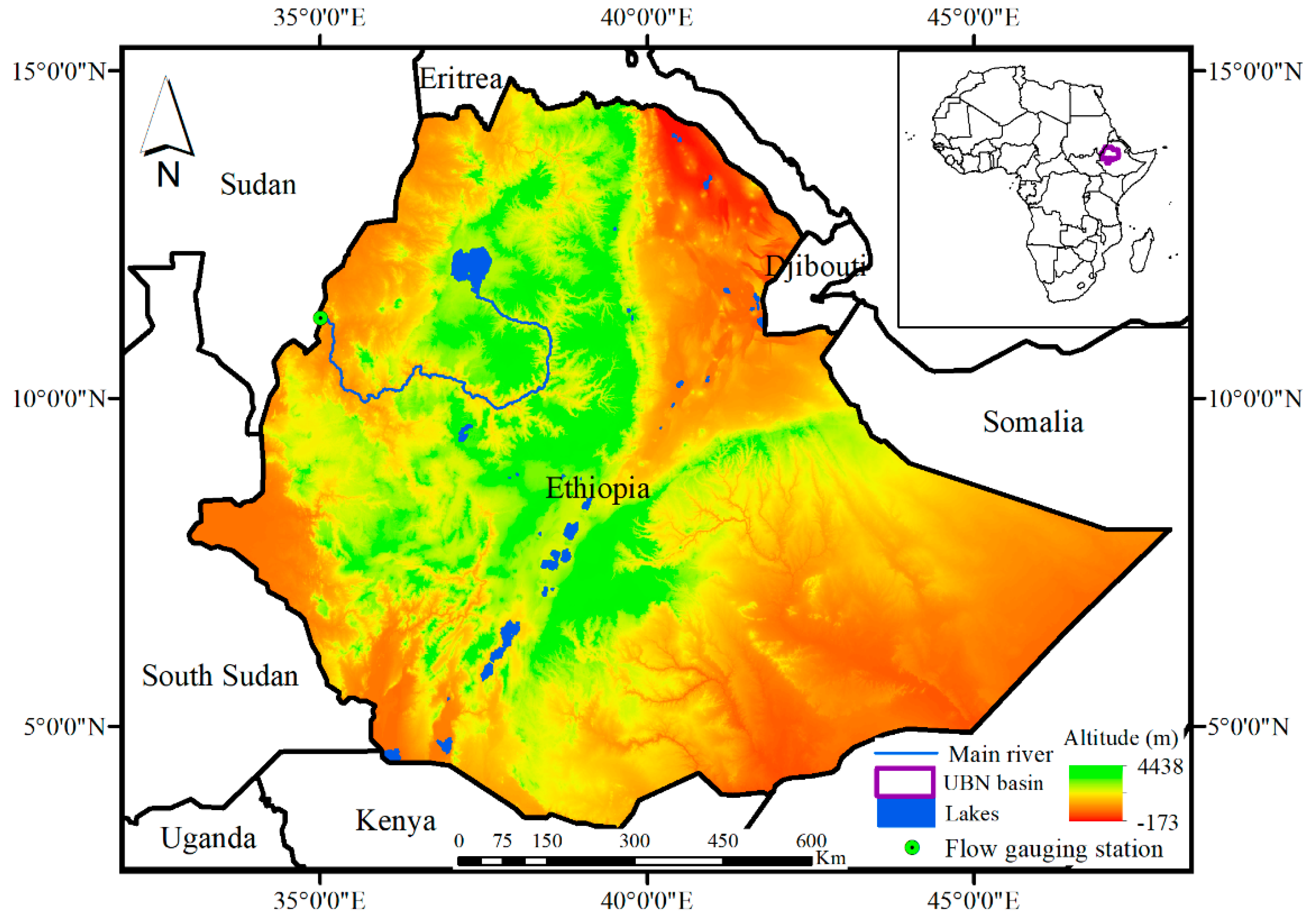
2. Study Area and Drought History
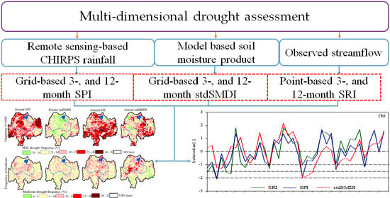
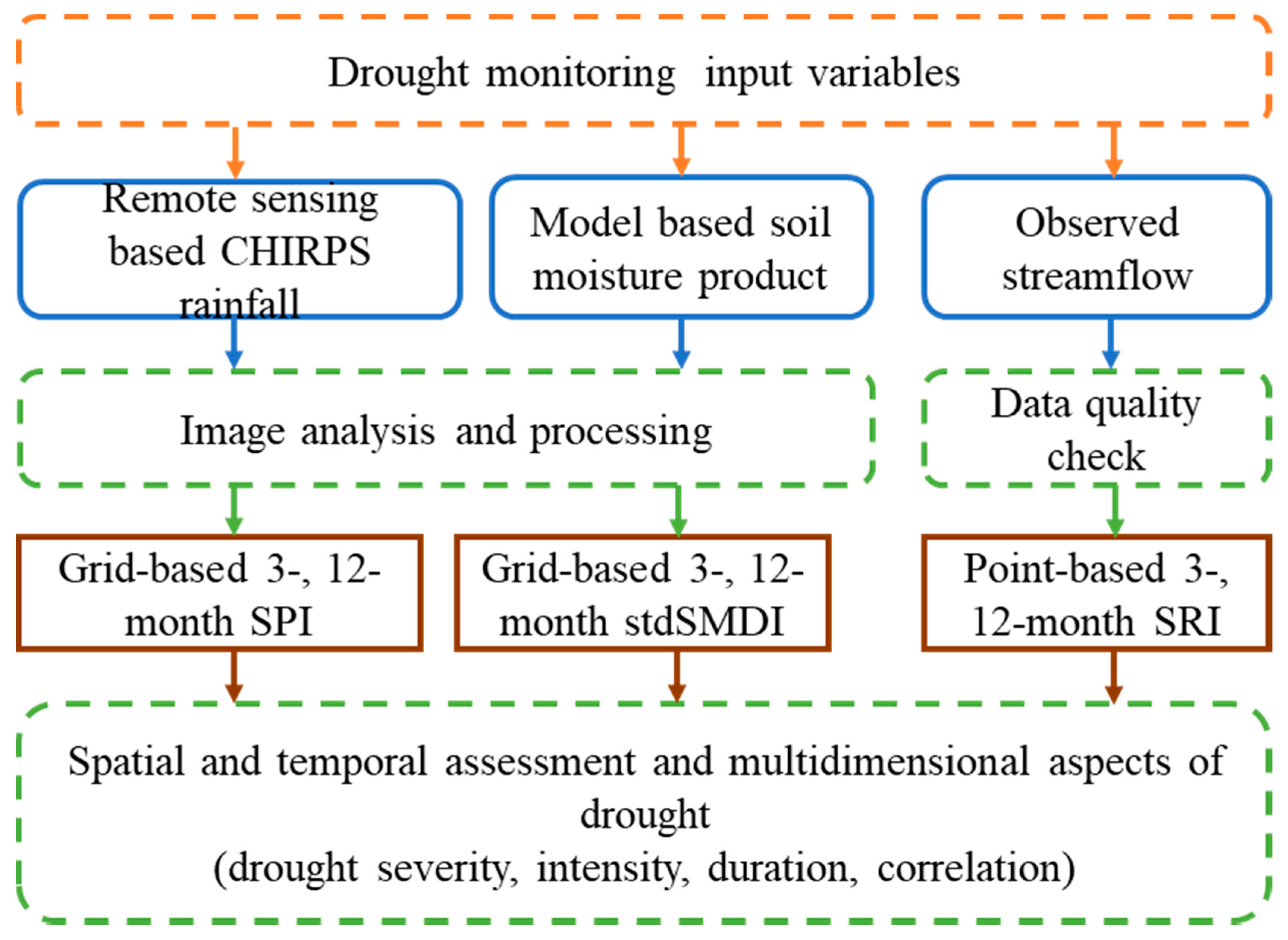
3. Materials and Methods
3.1. Data Used
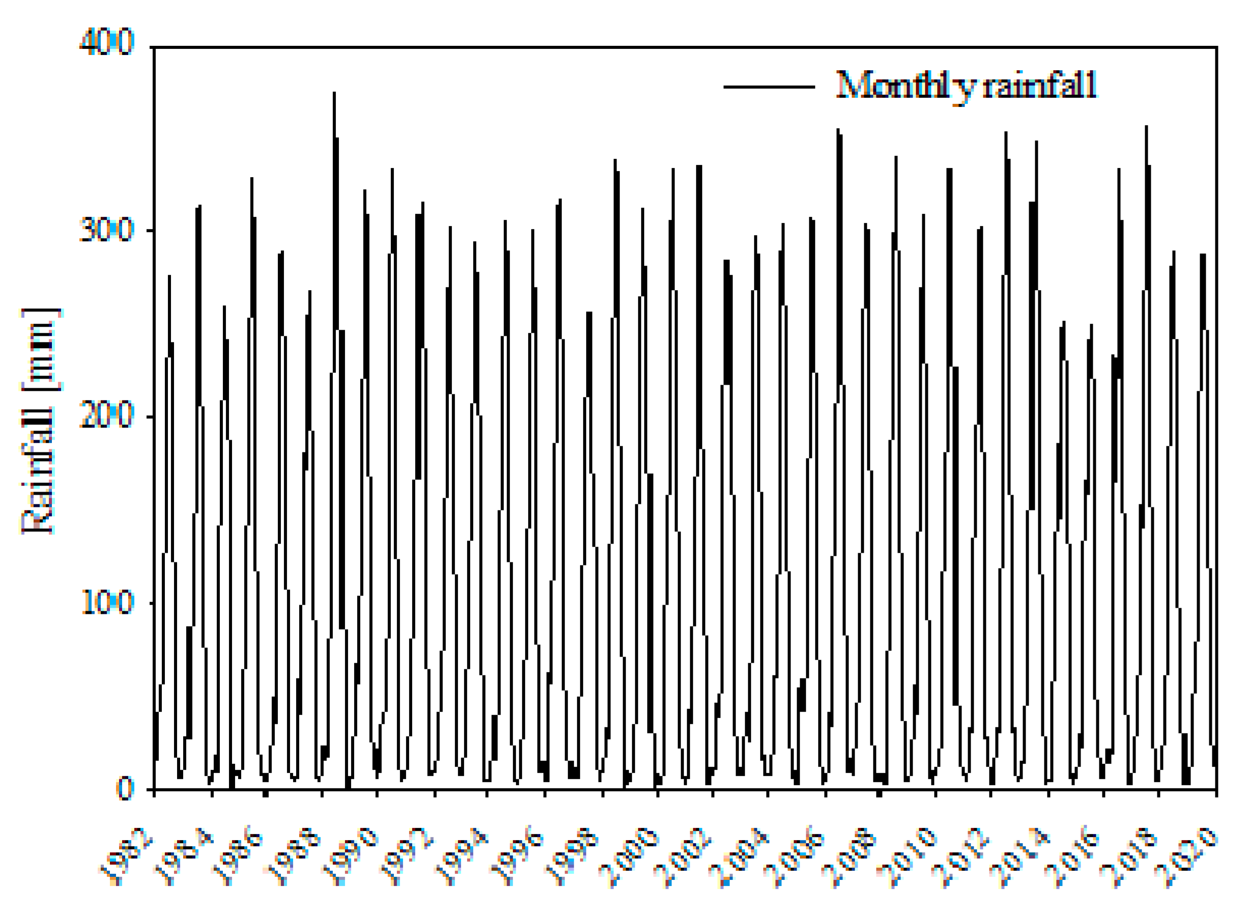
3.1.1. Satellite-Derived Rainfall Data
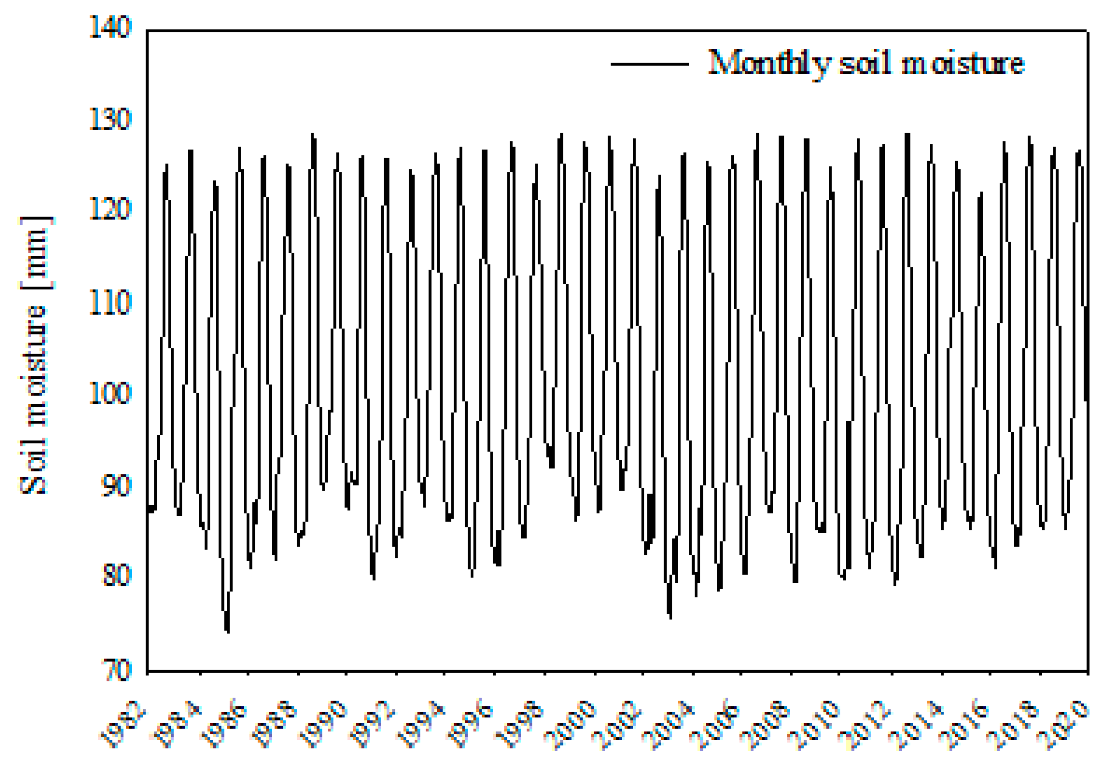
3.1.2. Soil Moisture Data
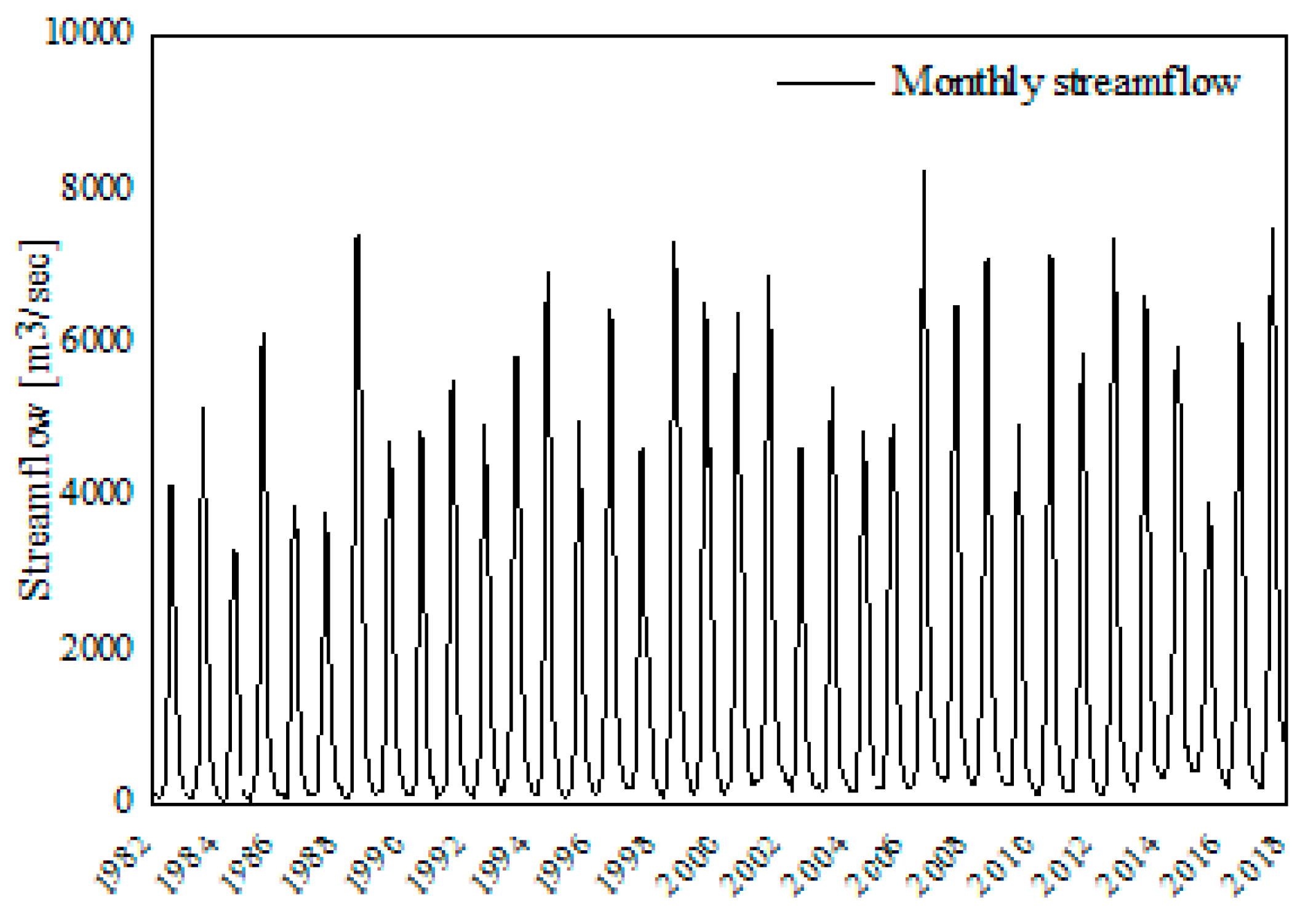
3.1.3. Streamflow Data
3.2. Drought Indices
3.2.1. Standardized Precipitation Index (SPI)
3.2.2. Soil Moisture Deficit Index (SMDI)
3.2.3. Standardized Runoff-Discharge Index (SRI)
4. Results
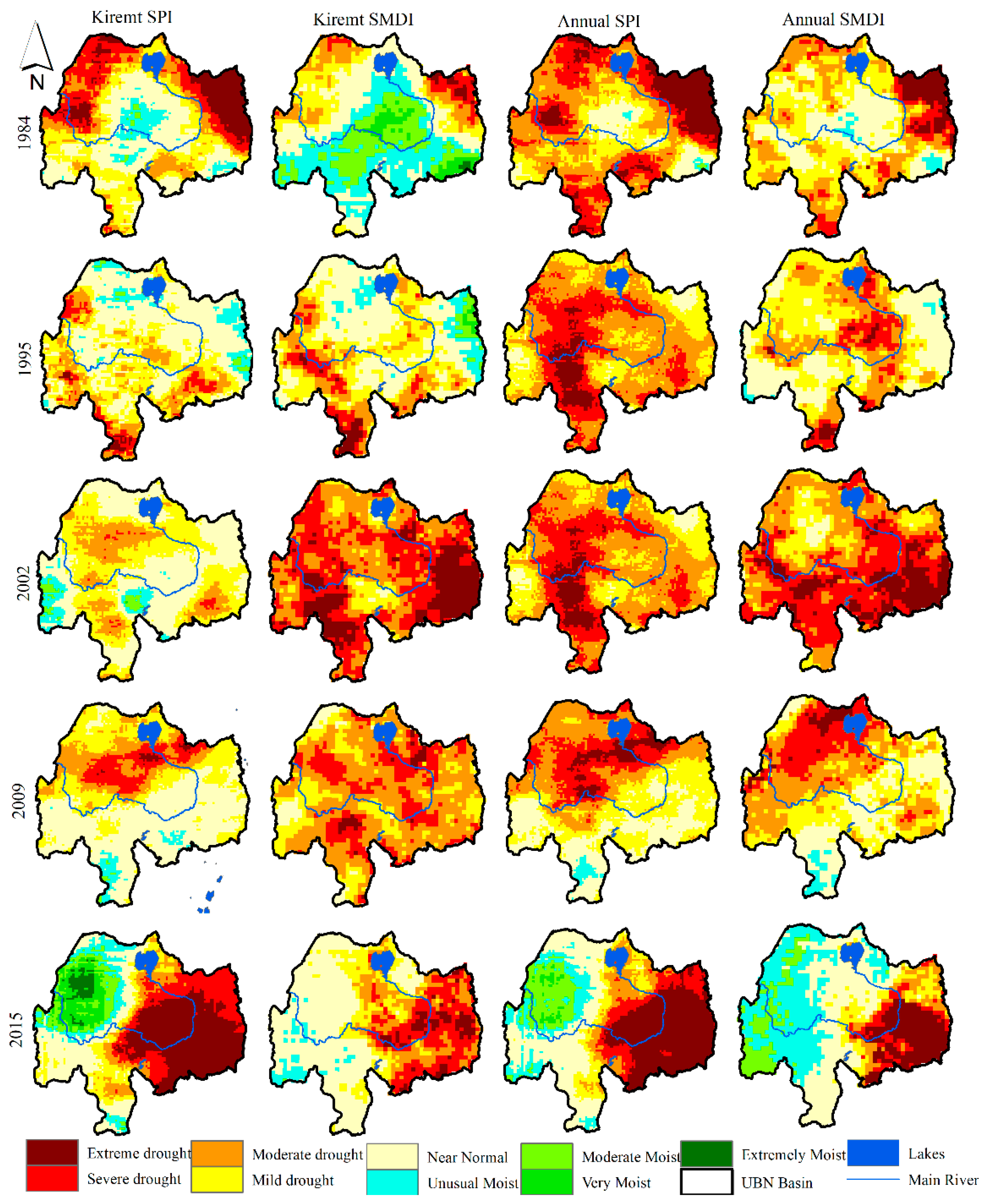
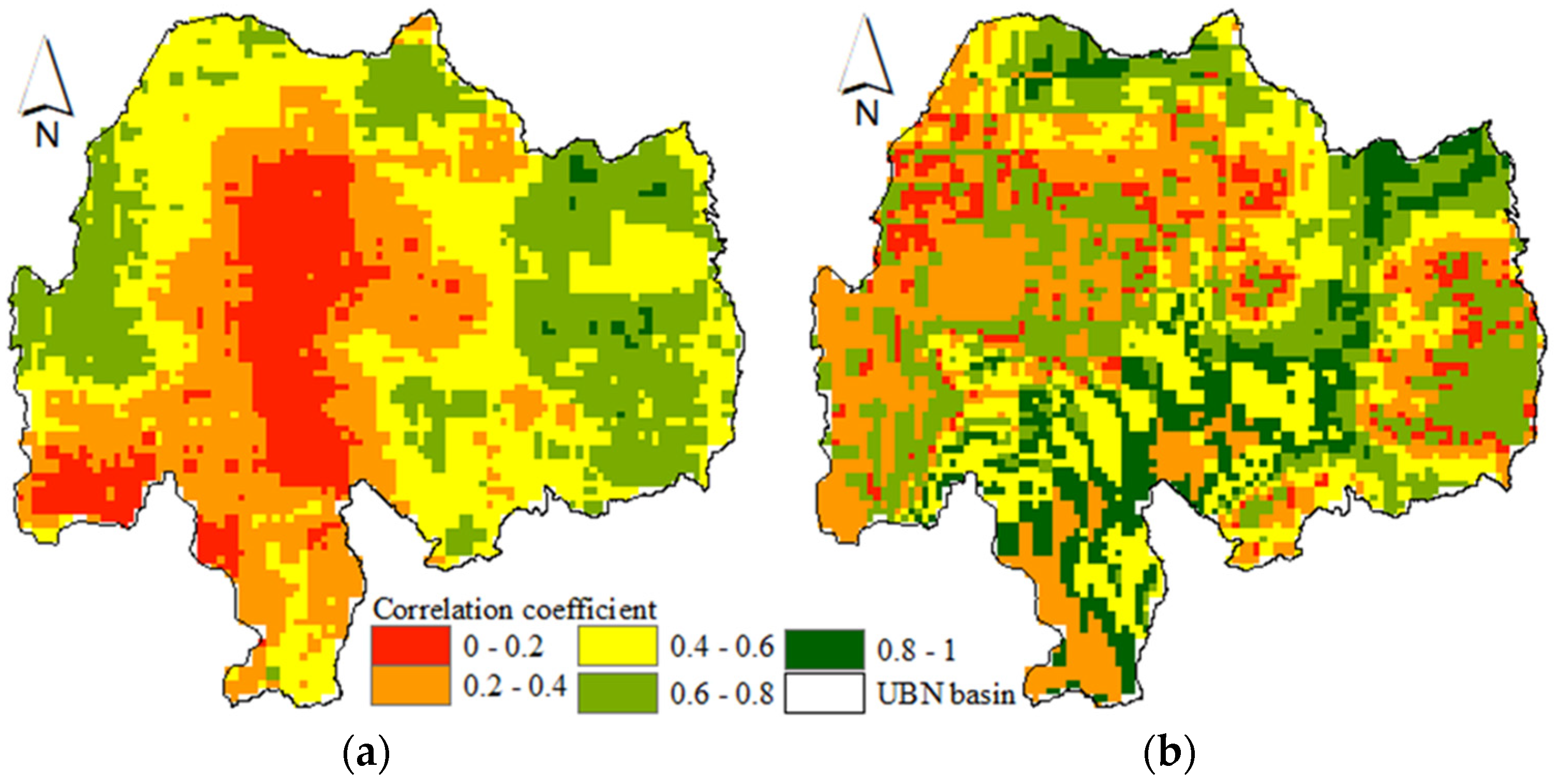
4.1. Spatial Pattern of Droughts
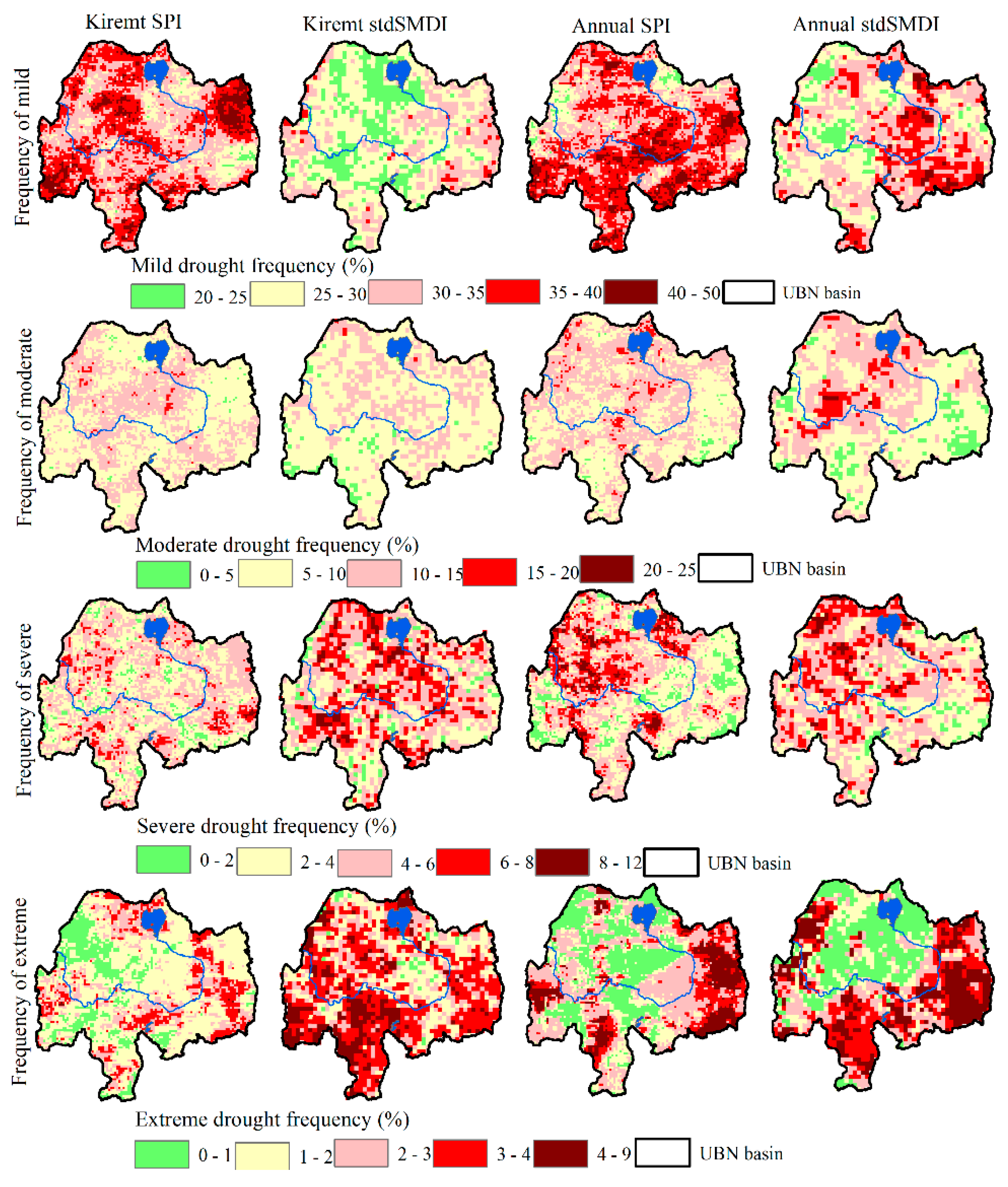
4.2. Spatial Patterns of the Frequency of Occurrence of Droughts
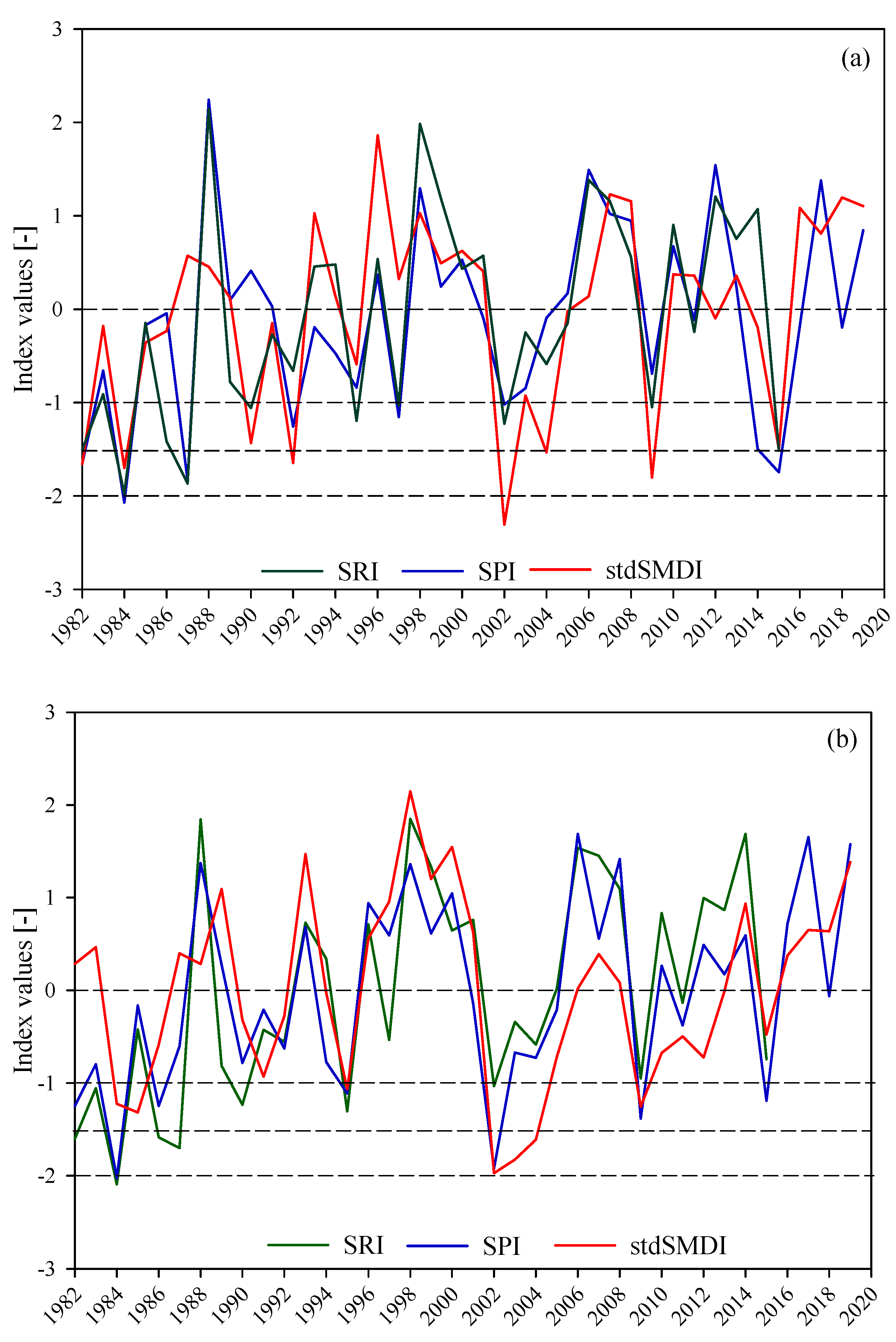
4.3. Temporal Patterns of Drought
5. Discussion
6. Conclusions and Recommendations
Author Contributions
Funding
Acknowledgments
Conflicts of Interest
Appendix A


References
- Wu, D.; Qu, J.; Hao, X. Agricultural drought monitoring using MODIS-based drought indices over the USA Corn Belt. Int. J. Remote Sens. 2015, 36, 5403–5425. [Google Scholar] [CrossRef]
- Viste, E.; Korecha, D.; Sorteberg, A. Recent drought and precipitation tendencies in Ethiopia. Theor. Appl. Climatol. 2013, 112, 535–551. [Google Scholar] [CrossRef]
- UNICEF. Ethiopia: Drought Crisis. Immediate Needs Overview. 2015. Available online: https://www.unicef.org/ethiopia/Drought_Crisis_Pitch.pdf (accessed on 6 January 2020).
- Wilhite, D.A. Drought as a natural hazard: Concepts and definitions. In Drought: A Global Assessment; Wilhite, D.A., Ed.; Routledge: London, UK, 2000; Volume 1, pp. 3–18. [Google Scholar]
- Wilhite, D.; Buchanan-Smith, M. Drought as hazard: Understanding the natural and social context. In Drought and Water Crises: Science, Technology, and Management Issues; Wilhite, D.A., Ed.; CRC Press: Boca Raton, FL, USA, 2005; pp. 3–29. [Google Scholar]
- Mishra, A.K.; Singh, V.P. A review of drought concepts. J. Hydrol. 2010, 391, 202–216. [Google Scholar] [CrossRef]
- McKee, T.B.; Doesken, N.J.; Kleist, J. Drought monitoring with multiple time scales. In Proceedings of the 9th Conference on Applied Climatology, Dallas, TX, USA, 15–20 January 1995; American Meteorological Society: Boston, MA, USA, 1995; pp. 233–236. [Google Scholar]
- Palmer, W.C. Meteorological Drought Vol. 30; US Department of Commerce, Weather Bureau: Washington, DC, USA, 1965.
- Vicente-Serrano, S.M.; Beguería, S.; López-Moreno, J.I. A multiscalar drought index sensitive to global warming: The standardized precipitation evapotranspiration index. J. Clim. 2010, 23, 1696–1718. [Google Scholar] [CrossRef]
- Byun, H.R.; Wilhite, D.A. Daily quantification of drought severity and duration. J. Clim. 1996, 5, 1181–1201. [Google Scholar]
- Narasimhan, B.; Srinivasan, R. Development and evaluation of Soil Moisture Deficit Index (SMDI) and Evapotranspiration Deficit Index (ETDI) for agricultural drought monitoring. Agric. For. Meteorol. 2005, 133, 69–88. [Google Scholar] [CrossRef]
- Nalbantis, I.; Tsakiris, G. Assessment of hydrological drought revisited. Water Resour. Manag. 2009, 23, 881–897. [Google Scholar] [CrossRef]
- Shukla, S.; Wood, A.W. Use of a standardized runoff index for characterizing hydrologic drought. Geophys. Res. Lett. 2008, 35. [Google Scholar] [CrossRef]
- Hughes, D.A. Comparison of satellite rainfall data with observations from gauging station networks. J. Hydrol. 2006, 327, 399–410. [Google Scholar] [CrossRef]
- Liu, W.T.; Kogan, F.N. Monitoring regional drought using the vegetation condition index. Int. J. Remote Sens. 1996, 17, 2761–2782. [Google Scholar] [CrossRef]
- Berhan, G.; Hill, S.; Tadesse, T.; Atnafu, S. Using satellite images for drought monitoring: A knowledge discovery approach. J. Strateg. Innov. Sustain. 2011, 7, 135. [Google Scholar]
- Quiring, S.M.; Papakryiakou, T.N. An evaluation of agricultural drought indices for the Canadian prairies. Agric. For. Meteorol. 2003, 118, 49–62. [Google Scholar] [CrossRef]
- Cai, G.; Du, M.; Liu, Y. Regional drought monitoring and analyzing using MODIS data—A case study in Yunnan Province. In Proceedings of the International Conference on Computer and Computing Technologies in Agriculture, Nanchang, China, 22–25 October 2010; Springer: Berlin/Heidelberg, Germany, 2010; pp. 243–251. [Google Scholar]
- Bayissa, Y.A.; Tadesse, T.; Svoboda, M.; Wardlow, B.; Poulsen, C.; Swigart, J.; Van Andel, S.J. Developing a satellite-based combined drought indicator to monitor agricultural drought: A case study for Ethiopia. Giscience Remote Sens. 2019, 56, 718–748. [Google Scholar] [CrossRef]
- Conway, D. The climate and hydrology of the Upper Blue Nile River. Geogr. J. 2000, 166, 49–62. [Google Scholar] [CrossRef]
- Yilma, A.D.; Awulachew, S.B. Characterization and atlas of the Blue Nile Basin and its sub basins. In Proceedings of the International Water Management Institute (IWMI), Colombo, Sri Lanka, 5–6 February 2009. [Google Scholar]
- Kebede, S.; Travi, Y.; Alemayehu, T.; Marc, V. Water balance of Lake Tana and its sensitivity to fluctuations in rainfall, Blue Nile basin, Ethiopia. J. Hydrol. 2006, 316, 233–247. [Google Scholar] [CrossRef]
- Mellander, P.E.; Gebrehiwot, S.G.; Gärdenäs, A.I.; Bewket, W.; Bishop, K. Summer rains and dry seasons in the Upper Blue Nile Basin: The predictability of half a century of past and future spatiotemporal patterns. PLoS ONE 2013, 8, e68461. [Google Scholar] [CrossRef] [PubMed]
- Degefu, M.A.; Rowell, D.P.; Bewket, W. Teleconnections between Ethiopian rainfall variability and global SSTs: Observations and methods for model evaluation. Meteorol. Atmos. Phys. 2017, 129, 173–186. [Google Scholar] [CrossRef]
- Tekleab, S.; Mohamed, Y.; Uhlenbrook, S. Hydro-climatic trends in the Abay/Upper Blue Nile basin, Ethiopia. Phys. Chem. Earth Parts A/B/C 2013, 61, 32–42. [Google Scholar] [CrossRef]
- Bayissa, Y.; Maskey, S.; Tadesse, T.; Van Andel, S.J.; Moges, S.; Van Griensven, A.; Solomatine, D. Comparison of the performance of six drought indices in characterizing historical drought for the upper Blue Nile basin, Ethiopia. Geosciences 2018, 8, 81. [Google Scholar] [CrossRef]
- Conway, D. From headwater tributaries to international river: Observing and adapting to climate variability and change in the Nile basin. Glob. Environ. Chang. 2005, 15, 99–114. [Google Scholar] [CrossRef]
- Stisen, S.; Sandholt, I. Evaluation of remote-sensing-based rainfall products through predictive capability in hydrological runoff modelling. Hydrol. Process. Int. J. 2010, 24, 879–891. [Google Scholar] [CrossRef]
- Bayissa, Y.; Tadesse, T.; Demisse, G.; Shiferaw, A. Evaluation of satellite-based rainfall estimates and application to monitor meteorological drought for the Upper Blue Nile Basin, Ethiopia. Remote Sens. 2017, 9, 669. [Google Scholar] [CrossRef]
- Fenta, A.A.; Yasuda, H.; Shimizu, K.; Ibaraki, Y.; Haregeweyn, N.; Kawai, T.; Belay, A.S.; Sultan, D.; Ebabu, K. Evaluation of satellite rainfall estimates over the Lake Tana basin at the source region of the Blue Nile River. Atmos. Res. 2018, 212, 43–53. [Google Scholar] [CrossRef]
- Basheer, M.; Elagib, N.A. Performance of satellite-based and GPCC 7.0 rainfall products in an extremely data-scarce country in the Nile Basin. Atmos. Res. 2019, 215, 128–140. [Google Scholar] [CrossRef]
- Saha, S.; Moorthi, S.; Pan, H.; Wu, X.; Wang, J.; Nadiga, S.; Tripp, P.; Kistler, R.; Woollen, J.; Behringer, D. The NCEP climate forecast system reanalysis. Bull. Am. Meteorol. Soc. 2010, 91, 1015–1058. [Google Scholar] [CrossRef]
- Funk, C.; Peterson, P.; Landsfeld, M.; Pedreros, D.; Verdin, J.; Rowland, J.; Romero, B.; Husak, G.; Michaelsen, J.; Verdin, A.; et al. A Quasi-Global Precipitation Time Series for Drought Monitoring. 2017. Available online: https://pubs.usgs.gov/ds/832/ (accessed on 20 January 2021).
- McNally, A.; Arsenault, K.; Kumar, S.; Shukla, S.; Peterson, P.; Wang, S.; Funk, C.; Peters-Lidard, C.D.; Verdin, J.P. A land data assimilation system for sub-Saharan Africa food and water security applications. Sci. Data 2017, 4, 1–19. [Google Scholar] [CrossRef] [PubMed]
- Anderson, W.; Zaitchik, B.; Hain, C.; Anderson, M.; Yilmaz, M.; Mecikalski, J.; Schultz, L. Towards an integrated soil moisture drought monitor for East Africa. Hydrol. Earth Syst. Sci. 2012, 16, 2893–2913. [Google Scholar] [CrossRef]
- Zaitchik, B.F.; Habib, S.; Anderson, M.; Ozdogan, M.; Alo, C. A Land Data Assimilation System for hydrologic studies in countries of the Nile basin. In Proceedings of the 8th International Conference of the African Association of Remote Sensing for the Environment, Addis Ababa, Ethiopia, 25–29 October 2010. [Google Scholar]
- Ntale, H.K.; Gan, T. Drought indices and their application to East Africa. Int. J. Clim. 2003, 23, 1335–1357. [Google Scholar] [CrossRef]
- McKee, T.B.; Doesken, N.J.; Kleist, J. The relationship of drought frequency and duration to time scales. In Proceedings of the 8th Conference on Applied Climatology, Anaheim, CA, USA, 17–22 January 1993; pp. 179–184. [Google Scholar]
- Khan, S.; Gabriel, H.; Rana, T. Standard Precipitation Index to track drought and assess impact of rainfall on water tables in irrigation areas. Irrig. Drain. Syst. 2008, 22, 159–177. [Google Scholar] [CrossRef]
- Moreira, E.E.; Coelho, C.A.; Paulo, A.A.; Pereira, L.S.; Mexia, J.T. SPI-based drought category prediction using loglinear models. J. Hydrol. 2008, 354, 116–130. [Google Scholar] [CrossRef]
- Bayissa, Y.; Semu, A.; Yunqing, X.; Schalk, A.; Shreedhar, M.; Dimitri, S.; Griensven, A.; Tadesse, T. Spatio-temporal assessment of meteorological drought under the influence of varying record length: The case of Upper Blue Nile Basin, Ethiopia. Hydrol. Sci. J. 2015, 60, 1927–1942. [Google Scholar] [CrossRef]
- Keyantash, J.A.; Dracup, J.A. An aggregate drought index: Assessing drought severity based on fluctuations in the hydrologic cycle and surface water storage. Water Resour. Res. 2004, 40. [Google Scholar] [CrossRef]
- Webb, P.; Braun, J.; Yohannes, Y. Famine in Ethiopia: Policy Implications of Coping Failure at National and Household Levels; Research Reports; International Food Policy Research Institute: Washington, DC, USA, 1992; Volume 92. [Google Scholar]
- Segele, Z.T.; Lamb, P.J. Characterization and variability of Kiremt rainy season over Ethiopia. Meteorol. Atmos. Phys. 2005, 89, 153–180. [Google Scholar] [CrossRef]
- Singh, R.; Worku, M.; Bogale, S.; Cullis, A.; Adem, A.; Irwin, B.; Lim, S.; Bosi, L.; Venton, C. Reality of resilience: Perspectives of the 2015-16 drought in Ethiopia. BRACED Resil. Intel 2016, 6, 1–28. [Google Scholar]
- Meseret, D. Land degradation in Amhara Region of Ethiopia: Review on extent, impacts and rehabilitation practices. J. Environ. Earth Sci. 2016, 6, 120–130. [Google Scholar]
- Lemann, T.; Roth, V.; Zeleke, G.; Subhatu, A.; Kassawmar, T.; Hurni, H. Spatial and temporal variability in hydrological responses of the Upper Blue Nile basin, Ethiopia. Water 2019, 11, 21. [Google Scholar] [CrossRef]


| SPI Value | Drought Category |
|---|---|
| −2.00 and less | Extreme |
| −1.50 to −1.99 | Severe |
| −1.00 to −1.49 | Moderate |
| 0 to −0.99 | Near normal or mild |
| 0 to 0.99 | Unusual moist |
| 1.00 to 1.49 | Moderate moist |
| 1.50 to 1.99 | Very moist |
| 2.00 and above | Extremely moist |
| Mild & Moderate Droughts | Severe & Extreme Droughts | Mild to Extreme Droughts (%) | ||||
|---|---|---|---|---|---|---|
| Kiremt SPI | Kiremt SMDI | Kiremt SPI | Kiremt SMDI | Kiremt SPI | Kiremt SMDI | |
| 1984 | 54 | 33 | 26 | 5 | 80 | 38 |
| 1995 | 69 | 64 | 6 | 10 | 75 | 74 |
| 2002 | 83 | 41 | 1 | 59 | 84 | 100 |
| 2009 | 46 | 76 | 0 | 24 | 46 | 100 |
| 2015 | 27 | 51 | 42 | 24 | 69 | 74 |
| Mild & Moderate Droughts | Severe & Extreme Droughts | Mild to Extreme Droughts (%) | ||||
|---|---|---|---|---|---|---|
| Annual SPI | Annual SMDI | Annual SPI | Annual SMDI | Annual SPI | Annual SMDI | |
| 1984 | 57 | 76 | 40 | 15 | 97 | 91 |
| 1995 | 80 | 76 | 9 | 12 | 89 | 89 |
| 2002 | 68 | 46 | 32 | 54 | 100 | 100 |
| 2009 | 71 | 72 | 23 | 20 | 94 | 92 |
| 2015 | 28 | 28 | 36 | 20 | 64 | 48 |
| Drought Indices | Pearson Correlation Coefficient | |
|---|---|---|
| Kiremt | Annual | |
| SPI vs. SRI | 0.79 | 0.85 |
| SPI vs. SMDI | 0.55 | 0.67 |
| SRI vs. SMDI | 0.64 | 0.5 |
| Kiremt | Annual | |||||
|---|---|---|---|---|---|---|
| Drought Index | SPI | stdSMDI | SRI | SPI | stdSMDI | SRI |
| 1983–1984 drought | ||||||
| Mean Intensity, M | −0.83 | −0.83 | −1.08 | −1.05 | −0.76 | −1.30 |
| Maximum intensity, Mmax | −2.26 | −2.48 | −2.01 | −2.07 | −2.07 | −2.14 |
| Duration, D (years) | 26 | 35 | 76 | 53 | 53 | 68 |
| Severity, S | −22 | −29 | −82 | −56 | −40 | −88 |
| 2002–2003 drought | ||||||
| Mean Intensity, M | −0.69 | −1.05 | −0.50 | −0.85 | −1.28 | −0.58 |
| Maximum intensity, Mmax | −1.75 | −2.34 | −1.25 | −2.03 | −2.59 | −1.05 |
| Duration, D (years) | 21 | 56 | 34 | 50 | 56 | 40 |
| Severity, S | −14 | −59 | −17 | −42 | −72 | −23 |
| 2009 drought | ||||||
| Mean Intensity, M | −0.44 | −1.15 | −0.76 | −1.00 | −0.62 | −0.82 |
| Maximum intensity, Mmax | −1.41 | −1.80 | −1.08 | −1.48 | −1.66 | −0.96 |
| Duration, D (years) | 16 | 15 | 12 | 14 | 55 | 12 |
| Severity, S | −7 | −17 | −9 | −14 | −34 | −10 |
| 2015 drought | ||||||
| Mean Intensity, M | −0.82 | −0.87 | −0.76 | −0.86 | −0.49 | −0.70 |
| Maximum intensity, Mmax | −2.35 | −2.25 | −1.08 | −1.41 | −0.78 | −0.80 |
| Duration, D (years) | 10 | 10 | 12 | 15 | 10 | 10 |
| Severity, S | −8 | −9 | −9 | −13 | −5 | −7 |
| Seasonal | Annual | |||||
|---|---|---|---|---|---|---|
| Drought Category | SPI | stdSMDI | SRI | SPI | stdSMDI | SRI |
| Mild drought | 34 | 29 | 29 | 34 | 24 | 24 |
| Moderate drought | 13 | 11 | 12 | 8 | 5 | 18 |
| Severe drought | 3 | 8 | 9 | 8 | 13 | 12 |
| Extreme drought | 3 | 0 | 3 | 3 | 3 | 0 |
Publisher’s Note: MDPI stays neutral with regard to jurisdictional claims in published maps and institutional affiliations. |
© 2021 by the authors. Licensee MDPI, Basel, Switzerland. This article is an open access article distributed under the terms and conditions of the Creative Commons Attribution (CC BY) license (https://creativecommons.org/licenses/by/4.0/).
Share and Cite
Bayissa, Y.; Moges, S.; Melesse, A.; Tadesse, T.; Abiy, A.Z.; Worqlul, A. Multi-Dimensional Drought Assessment in Abbay/Upper Blue Nile Basin: The Importance of Shared Management and Regional Coordination Efforts for Mitigation. Remote Sens. 2021, 13, 1835. https://doi.org/10.3390/rs13091835
Bayissa Y, Moges S, Melesse A, Tadesse T, Abiy AZ, Worqlul A. Multi-Dimensional Drought Assessment in Abbay/Upper Blue Nile Basin: The Importance of Shared Management and Regional Coordination Efforts for Mitigation. Remote Sensing. 2021; 13(9):1835. https://doi.org/10.3390/rs13091835
Chicago/Turabian StyleBayissa, Yared, Semu Moges, Assefa Melesse, Tsegaye Tadesse, Anteneh Z. Abiy, and Abeyou Worqlul. 2021. "Multi-Dimensional Drought Assessment in Abbay/Upper Blue Nile Basin: The Importance of Shared Management and Regional Coordination Efforts for Mitigation" Remote Sensing 13, no. 9: 1835. https://doi.org/10.3390/rs13091835
APA StyleBayissa, Y., Moges, S., Melesse, A., Tadesse, T., Abiy, A. Z., & Worqlul, A. (2021). Multi-Dimensional Drought Assessment in Abbay/Upper Blue Nile Basin: The Importance of Shared Management and Regional Coordination Efforts for Mitigation. Remote Sensing, 13(9), 1835. https://doi.org/10.3390/rs13091835