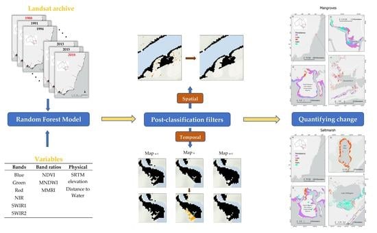
Mangrove and Saltmarsh Distribution Mapping and Land Cover Change Assessment for South-Eastern Australia from 1991 to 2015
Abstract
1. Introduction
2. Materials and Methods
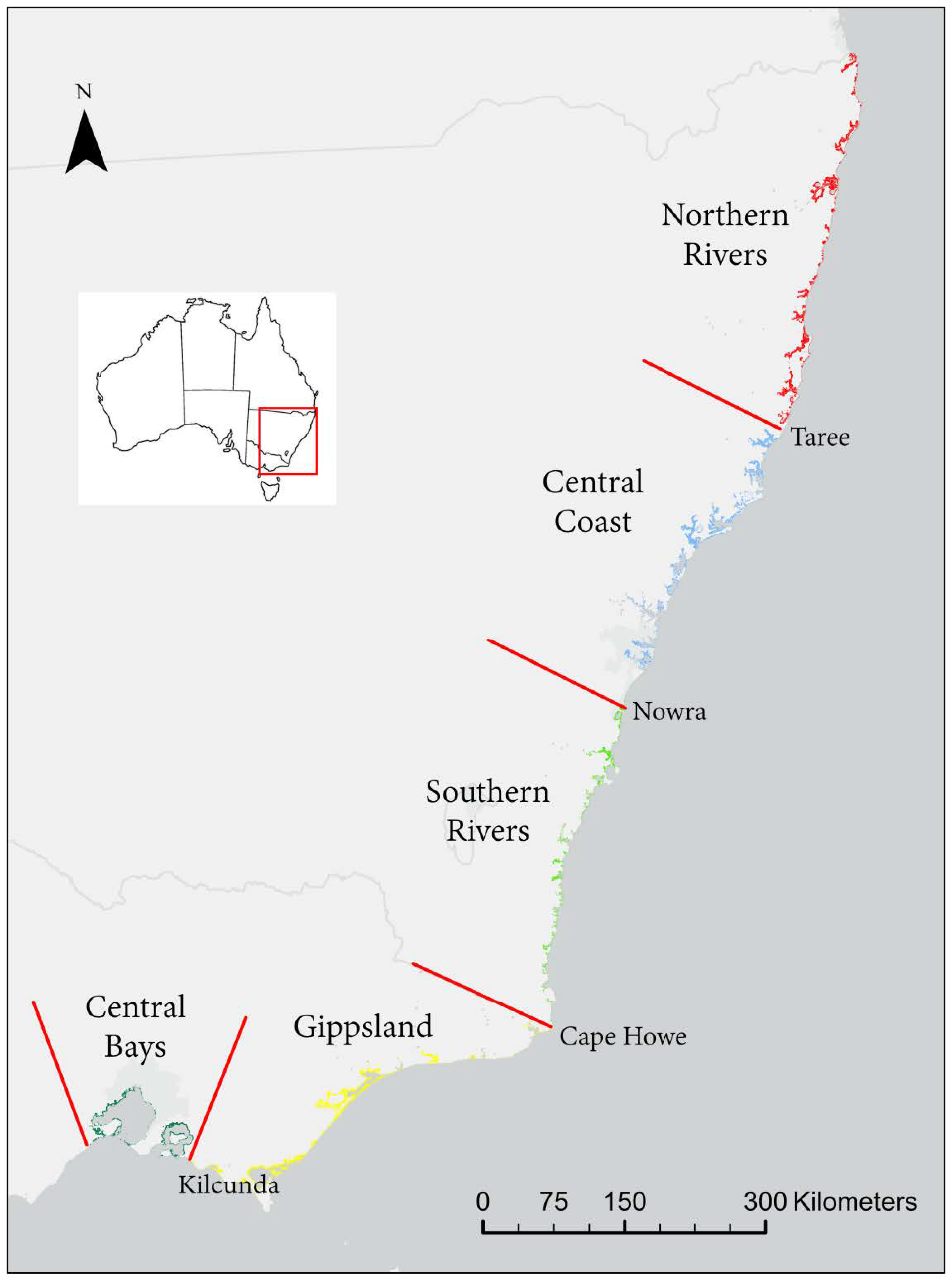
2.1. Study Area
2.2. Landsat Imagery Acquisition and Pre-Processing
2.3. Data Masking
2.4. Coastal Wetlands Classification
2.4.1. Training and Validation Datasets
2.4.2. Random Forest Model
2.4.3. Post-Classification Filters
2.4.4. Accuracy Assessment and Validation
2.5. Land-Cover Transitions
3. Results
3.1. Random Forest Classification
3.2. Post-Classification Filters
3.3. Coastal Wetlands in South-Eastern Australia
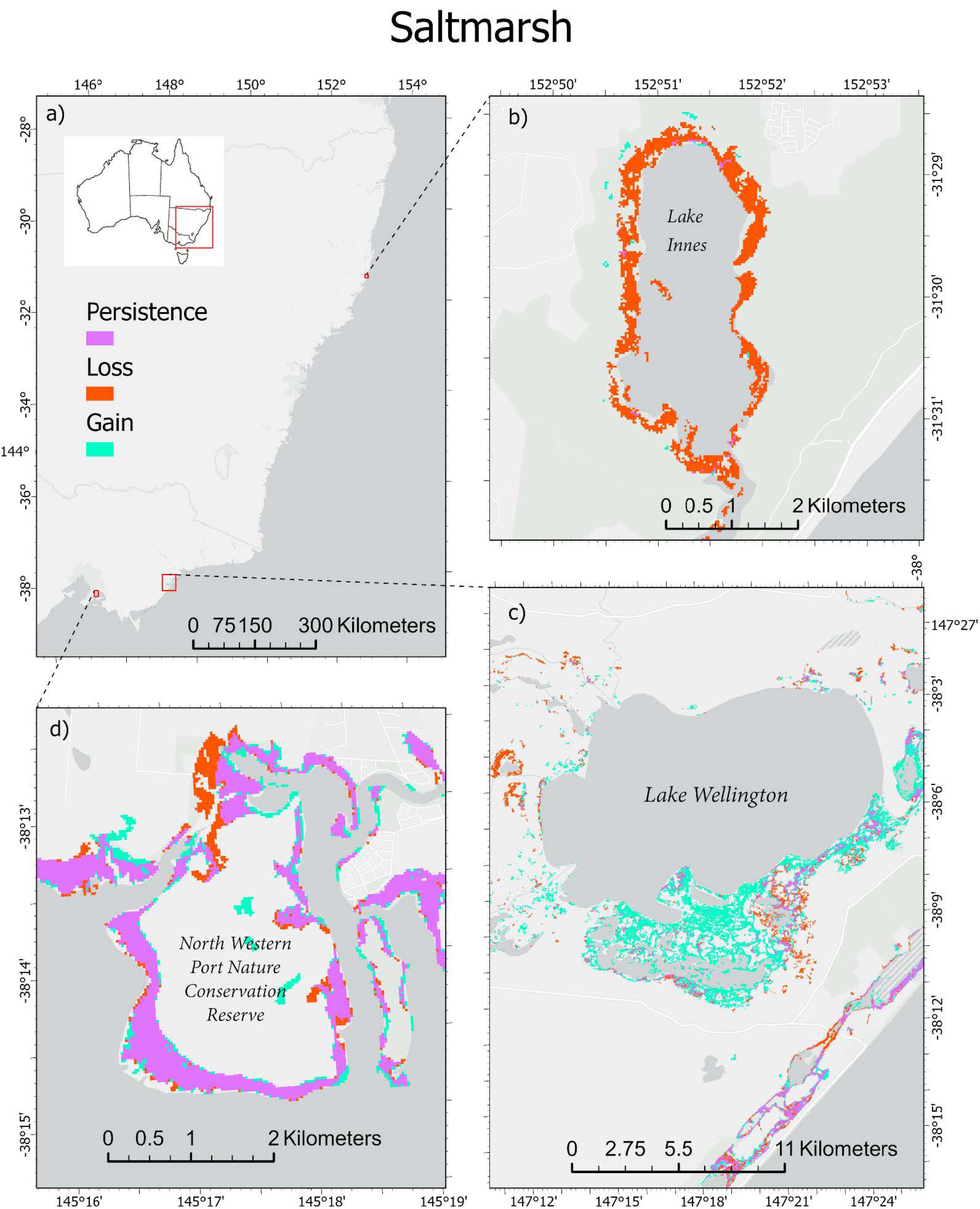
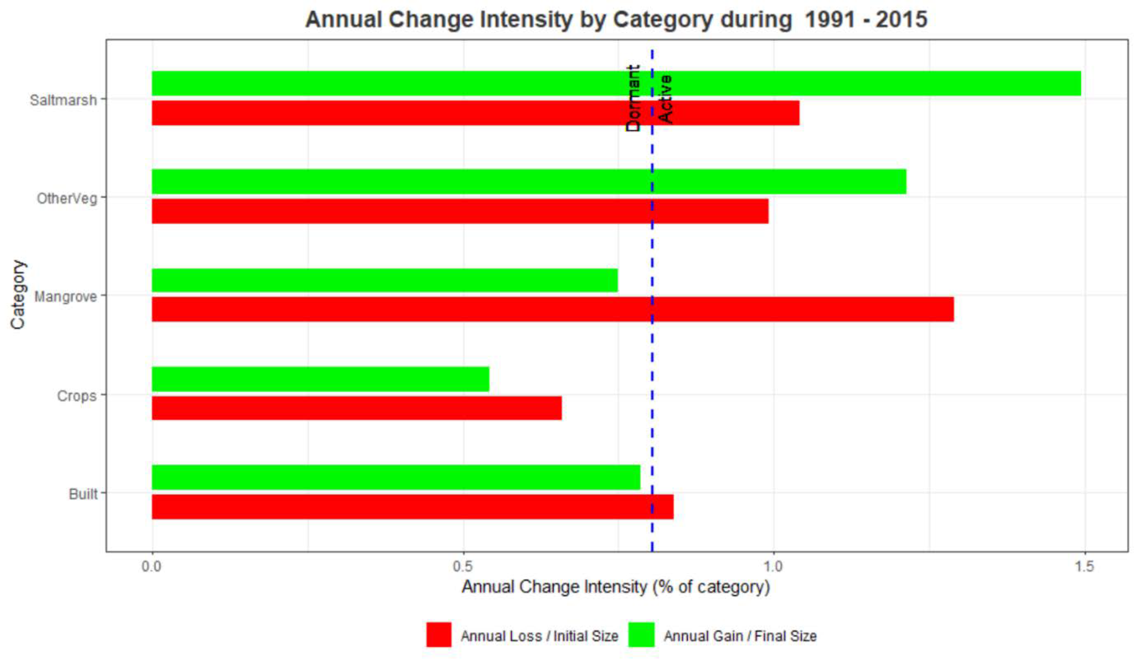
3.4. Land-Cover Change
4. Discussion
4.1. Accuracy Assessment
4.2. Mangrove and Saltmarsh Distribution
4.3. Land-Cover Change
4.4. Potential Data Applications and Management Implications
5. Conclusions
Supplementary Materials
Author Contributions
Funding
Data Availability Statement
Conflicts of Interest
References
- Alongi, D.M. Mangrove forests: Resilience, protection from tsunamis, and responses to global climate change. Estuar. Coast. Shelf Sci. 2008, 76, 1–13. [Google Scholar] [CrossRef]
- Atwood, T.B.; Connolly, R.M.; Almahasheer, H.; Carnell, P.E.; Duarte, C.M.; Lewis, C.J.E.; Irigoien, X.; Kelleway, J.J.; Lavery, P.S.; Macreadie, P.I. Global patterns in mangrove soil carbon stocks and losses. Nat. Clim. Chang. 2017, 7, 523. [Google Scholar] [CrossRef]
- Das, S.; Vincent, J.R. Mangroves protected villages and reduced death toll during Indian super cyclone. Proc. Natl. Acad. Sci. USA 2009, 106, 7357–7360. [Google Scholar] [CrossRef] [PubMed]
- Hemminga, M.A.; Duarte, C.M. Seagrass Ecology; Cambridge University Press: Cambridge, UK, 2000. [Google Scholar]
- Mcleod, E.; Chmura, G.L.; Bouillon, S.; Salm, R.; Björk, M.; Duarte, C.M.; Lovelock, C.E.; Schlesinger, W.H.; Silliman, B.R. A blueprint for blue carbon: Toward an improved understanding of the role of vegetated coastal habitats in sequestering CO2. Front. Ecol. Environ. 2011, 9, 552–560. [Google Scholar] [CrossRef]
- Clark, G.F.; Johnston, E.L. Coasts. Australia State of the Environment; Government Department of the Environment and Energy: Canberra, Australia, 2016. Available online: https://soe.environment.gov.au/theme/coasts (accessed on 6 April 2021).
- Richards, D.R.; Friess, D.A. Rates and drivers of mangrove deforestation in Southeast Asia, 2000–2012. Proc. Natl. Acad. Sci. USA 2016, 113, 344–349. [Google Scholar] [CrossRef]
- Duke, N.C.; Kovacs, J.M.; Griffiths, A.D.; Preece, L.; Hill, D.J.E.; van Oosterzee, P.; Mackenzie, J.; Morning, H.S.; Burrows, D. Large-scale dieback of mangroves in Australia’s Gulf of Carpentaria: A severe ecosystem response, coincidental with an unusually extreme weather event. Mar. Freshw. Res. 2017, 68, 1816–1829. [Google Scholar] [CrossRef]
- Lugo, A.E. Effects and outcomes of Caribbean hurricanes in a climate change scenario. Sci. Total Environ. 2000, 262, 243–251. [Google Scholar] [CrossRef]
- Ward, R.D.; Friess, D.A.; Day, R.H.; MacKenzie, R.A. Impacts of climate change on mangrove ecosystems: A region by region overview. Ecosyst. Health Sustain. 2016, 2. [Google Scholar] [CrossRef]
- Zann, L.P. The eastern Australian region: A dynamic tropical/temperate biotone. Mar. Pollut. Bull. 2000, 41, 188–203. [Google Scholar] [CrossRef]
- Montreal Process Implementation Group for Australia and National Forest Inventory Steering Committee. Australia’s State of the Forests Report 2018; ABARES: Canberra, Australia, 2018. [Google Scholar]
- Lymburner, L.; Bunting, P.; Lucas, R.; Scarth, P.; Alam, I.; Phillips, C.; Ticehurst, C.; Held, A. Mapping the multi-decadal mangrove dynamics of the Australian coastline. Remote Sens. Environ. 2020, 238, 111185. [Google Scholar] [CrossRef]
- Act, E. Environment Protection and Biodiversity Conservation Act; ABARES: Canberra, Australia, 1999. [Google Scholar]
- Saintilan, N.; Williams, R. Short Note: The decline of saltmarsh in southeast Australia: Results of recent surveys. Wetl. Aust. 2010, 18. [Google Scholar] [CrossRef]
- Sinclair, S.; Boon, P.I. Changes in the area of coastal marsh in Victoria since the mid19th century. Cunninghamia 2012, 12, 153–176. [Google Scholar]
- Gulliver, A.; Carnell, P.E.; Trevathan-Tackett, S.M.; Duarte de Paula Costa, M.; Masqué, P.; Macreadie, P.I. Estimating the potential blue carbon gains from tidal marsh rehabilitation: A case study from south eastern Australia. Front. Mar. Sci. 2020, 7, 403. [Google Scholar] [CrossRef]
- Hurst, T. Restoration of Temperate Mangrove Ecosystems; Deakin University: Melbourne, Australia, 2018. [Google Scholar]
- Russell, K. NSW Northern Rivers Estuary Habitat Mapping-Final Analysis Report; NSW Department of Primary Industries: Port Stephens, Australia, 2005. [Google Scholar]
- Adame, M.; Hermoso, V.; Perhans, K.; Lovelock, C.; Herrera-Silveira, J. Selecting cost-effective areas for restoration of ecosystem services. Conserv. Biol. 2015, 29, 493–502. [Google Scholar] [CrossRef] [PubMed]
- Hardisky, M.; Gross, M.; Klemas, V. Remote sensing of coastal wetlands. Bioscience 1986, 36, 453–460. [Google Scholar] [CrossRef]
- Worthington, T.; Spalding, M. Mangrove restoration potential: A global map highlighting a critical opportunity. Apollo 2018. [Google Scholar] [CrossRef]
- Boon, P.; Allen, T.; Brook, J.; Carr, G.; Frood, D.; Harty, C.; Hoye, J.; McMahon, A.; Mathews, S.; Rosengren, N. Victorian Saltmarsh Study. Mangroves and Coastal Saltmarsh of Victoria: Distribution, Condition, Threats and Management; Institute for Sustainability and Innovation, Victoria University: Melbourne, Australia, 2011. [Google Scholar]
- Creese, R.; Glasby, T.; West, G.; Gallen, C. Mapping the habitats of NSW estuaries. Nelson Bay NSW 2009, 113, 1837–2112. [Google Scholar]
- Whitt, A.A.; Coleman, R.; Lovelock, C.E.; Gillies, C.; Ierodiaconou, D.; Liyanapathirana, M.; Macreadie, P.I. March of the mangroves: Drivers of encroachment into southern temperate saltmarsh. Estuar. Coast. Shelf Sci. 2020, 240, 106776. [Google Scholar] [CrossRef]
- Dustin, M.C. Monitoring Parks with Inexpensive UAVs: Cost Benefits Analysis for Monitoring and Maintaining Parks Facilities; University of Southern California: Los Angeles, CA, USA, 2015. [Google Scholar]
- Mumby, P.; Green, E.; Edwards, A.; Clark, C. The cost-effectiveness of remote sensing for tropical coastal resources assessment and management. J. Environ. Manag. 1999, 55, 157–166. [Google Scholar] [CrossRef]
- Giri, C. Observation and Monitoring of Mangrove Forests Using Remote Sensing: Opportunities and Challenges. Remote Sens. 2016, 8, 783. [Google Scholar] [CrossRef]
- Kuenzer, C.; Bluemel, A.; Gebhardt, S.; Quoc, T.V.; Dech, S. Remote Sensing of Mangrove Ecosystems: A Review. Remote Sens. 2011, 3, 878–928. [Google Scholar] [CrossRef]
- Pham, T.D.; Yokoya, N.; Bui, D.T.; Yoshino, K.; Friess, D.A. Remote Sensing Approaches for Monitoring Mangrove Species, Structure, and Biomass: Opportunities and Challenges. Remote Sens. 2019, 11, 230. [Google Scholar] [CrossRef]
- Bunting, P.; Rosenqvist, A.; Lucas, R.M.; Rebelo, L.M.; Hilarides, L.; Thomas, N.; Hardy, A.; Itoh, T.; Shimada, M.; Finlayson, C.M. The Global Mangrove WatchA New 2010 Global Baseline of Mangrove Extent. Remote Sens. 2018, 10, 1669. [Google Scholar] [CrossRef]
- Fatoyinbo, T.E.; Simard, M.; Washington-Allen, R.A.; Shugart, H.H. Landscape-scale extent, height, biomass, and carbon estimation of Mozambique’s mangrove forests with Landsat ETM+ and Shuttle Radar Topography Mission elevation data. J. Geophys. Res. Biogeosci. 2008, 113. [Google Scholar] [CrossRef]
- Giri, C.; Ochieng, E.; Tieszen, L.L.; Zhu, Z.; Singh, A.; Loveland, T.; Masek, J.; Duke, N. Status and distribution of mangrove forests of the world using earth observation satellite data. Glob. Ecol. Biogeogr. 2011, 20, 154–159. [Google Scholar] [CrossRef]
- Heumann, B.W. Satellite remote sensing of mangrove forests: Recent advances and future opportunities. Prog. Phys. Geogr. 2011, 35, 87–108. [Google Scholar] [CrossRef]
- Wulder, M.A.; White, J.C.; Loveland, T.R.; Woodcock, C.E.; Belward, A.S.; Cohen, W.B.; Fosnight, E.A.; Shaw, J.; Masek, J.G.; Roy, D.P. The global Landsat archive: Status, consolidation, and direction. Remote Sens. Environ. 2016, 185, 271–283. [Google Scholar] [CrossRef]
- Calderón-Loor, M.; Hadjikakou, M.; Bryan, B.A. High-resolution wall-to-wall land-cover mapping and land change assessment for Australia from 1985 to 2015. Remote Sens. Environ. 2021, 252, 112148. [Google Scholar] [CrossRef]
- Giri, C.; Long, J.; Abbas, S.; Murali, R.M.; Qamer, F.M.; Pengra, B.; Thau, D. Distribution and dynamics of mangrove forests of South Asia. J. Environ. Manag. 2015, 148, 101–111. [Google Scholar] [CrossRef] [PubMed]
- Murray, N.J.; Phinn, S.R.; DeWitt, M.; Ferrari, R.; Johnston, R.; Lyons, M.B.; Clinton, N.; Thau, D.; Fuller, R.A. The global distribution and trajectory of tidal flats. Nature 2019, 565, 222–225. [Google Scholar] [CrossRef]
- Song, X.-P.; Hansen, M.C.; Stehman, S.V.; Potapov, P.V.; Tyukavina, A.; Vermote, E.F.; Townshend, J.R. Global land change from 1982 to 2016. Nature 2018, 560, 639–643. [Google Scholar] [CrossRef]
- Diniz, C.; Cortinhas, L.; Nerino, G.; Rodrigues, J.; Sadeck, L.; Adami, M.; Souza-Filho, P.W.M. Brazilian mangrove status: Three decades of satellite data analysis. Remote Sens. 2019, 11, 808. [Google Scholar] [CrossRef]
- Gupta, K.; Mukhopadhyay, A.; Giri, S.; Chanda, A.; Majumdar, S.D.; Samanta, S.; Mitra, D.; Samal, R.N.; Pattnaik, A.K.; Hazra, S. An index for discrimination of mangroves from non-mangroves using LANDSAT 8 OLI imagery. MethodsX 2018, 5, 1129–1139. [Google Scholar] [CrossRef]
- Wen, L.; Hughes, M. Coastal wetland mapping using ensemble learning algorithms: A comparative study of bagging, boosting and stacking techniques. Remote Sens. 2020, 12, 1683. [Google Scholar] [CrossRef]
- Rogan, J.; Franklin, J.; Stow, D.; Miller, J.; Woodcock, C.; Roberts, D. Mapping land-cover modifications over large areas: A comparison of machine learning algorithms. Remote Sens. Environ. 2008, 112, 2272–2283. [Google Scholar] [CrossRef]
- Heumann, B.W. An Object-Based Classification of Mangroves Using a Hybrid Decision Tree-Support Vector Machine Approach. Remote Sens. 2011, 3, 2440–2460. [Google Scholar] [CrossRef]
- Bwangoy, J.R.B.; Hansen, M.C.; Roy, D.P.; De Grandi, G.; Justice, C.O. Wetland mapping in the Congo Basin using optical and radar remotely sensed data and derived topographical indices. Remote Sens. Environ. 2010, 114, 73–86. [Google Scholar] [CrossRef]
- Renno, C.D.; Nobre, A.D.; Cuartas, L.A.; Soares, J.V.; Hodnett, M.G.; Tomasella, J.; Waterloo, M.J. HAND, a new terrain descriptor using SRTM-DEM: Mapping terra-firme rainforest environments in Amazonia. Remote Sens. Environ. 2008, 112, 3469–3481. [Google Scholar] [CrossRef]
- Wolanski, E.; Brinson, M.M.; Cahoon, D.R.; Perillo, G.M. Coastal Wetlands: A synthesis. In Coastal Wetlands an Integrated Ecosystem Approach; Elsevier: Amsterdam, The Netherlands, 2009; pp. 1–62. [Google Scholar]
- Macnae, W. Mangroves in eastern and southern Australia. Aust. J. Bot. 1966, 14, 67–104. [Google Scholar] [CrossRef]
- Farr, T.G.; Rosen, P.A.; Caro, E.; Crippen, R.; Duren, R.; Hensley, S.; Kobrick, M.; Paller, M.; Rodriguez, E.; Roth, L. The shuttle radar topography mission. Rev. Geophys. 2007, 45. [Google Scholar] [CrossRef]
- Vandervalk, A.G.; Attiwill, P.M. Decomposition of leaf and root litter of Avicennia-marina at Westernport Bay, Victoria, Australia. Aquat. Bot. 1984, 18, 205–221. [Google Scholar] [CrossRef]
- Adam, P.; Wilson, N.; Huntley, B. The phytosociology of coastal saltmarsh vegetation in New South Wales. Wetl. Aust. 2010, 7. [Google Scholar] [CrossRef]
- Li, F.; Jupp, D.L.; Reddy, S.; Lymburner, L.; Mueller, N.; Tan, P.; Islam, A. An evaluation of the use of atmospheric and BRDF correction to standardize Landsat data. IEEE J. Sel. Top. Appl. Earth Obs. Remote Sens. 2010, 3, 257–270. [Google Scholar] [CrossRef]
- Zhu, Z.; Woodcock, C.E. Object-based cloud and cloud shadow detection in Landsat imagery. Remote Sens. Environ. 2012, 118, 83–94. [Google Scholar] [CrossRef]
- Foga, S.; Scaramuzza, P.L.; Guo, S.; Zhu, Z.; Dilley, R.D., Jr.; Beckmann, T.; Schmidt, G.L.; Dwyer, J.L.; Hughes, M.J.; Laue, B. Cloud detection algorithm comparison and validation for operational Landsat data products. Remote Sens. Environ. 2017, 194, 379–390. [Google Scholar] [CrossRef]
- Gorelick, N.; Hancher, M.; Dixon, M.; Ilyushchenko, S.; Thau, D.; Moore, R. Google Earth Engine: Planetary-scale geospatial analysis for everyone. Remote Sens. Environ. 2017, 202, 18–27. [Google Scholar] [CrossRef]
- Held, A.; Ticehurst, C.; Lymburner, L.; Williams, N. High resolution mapping of tropical mangrove ecosystems using hyperspectral and radar remote sensing. Int. J. Remote Sens. 2003, 24, 2739–2759. [Google Scholar] [CrossRef]
- Navarro, A.; Young, M.; Allan, B.; Carnell, P.; Macreadie, P.; Ierodiaconou, D. The application of Unmanned Aerial Vehicles (UAVs) to estimate above-ground biomass of mangrove ecosystems. Remote Sens. Environ. 2020, 242, 111747. [Google Scholar] [CrossRef]
- State Government of NSW and Department of Planning Industry and Environment. NSW Landuse 2007; Department of Planning, Industry and Environment: Parramatta, Australia, 2010.
- State Government of VIC and Department of Environment Land Water and Planning. VIC Landuse 2006; Department of Environment Land Water and Planning: Melbourne, Australia, 2006.
- Millard, K.; Richardson, M. On the Importance of Training Data Sample Selection in Random Forest Image Classification: A Case Study in Peatland Ecosystem Mapping. Remote Sens. 2015, 7, 8489–8515. [Google Scholar] [CrossRef]
- Young, N.E.; Anderson, R.S.; Chignell, S.M.; Vorster, A.G.; Lawrence, R.; Evangelista, P.H. A survival guide to Landsat preprocessing. Ecology 2017, 98, 920–932. [Google Scholar] [CrossRef]
- Breiman, L. Random forests. Mach. Learn. 2001, 45, 5–32. [Google Scholar] [CrossRef]
- Liaw, A.; Wiener, M. Classification and regression by randomForest. R News 2002, 2, 18–22. [Google Scholar]
- Rouse, J.; Haas, R.H.; Schell, J.A.; Deering, D.W. Monitoring vegetation systems in the Great Plains with ERTS. NASA Spec. Publ. 1974, 351, 309. [Google Scholar]
- Xu, H.Q. Modification of normalised difference water index (NDWI) to enhance open water features in remotely sensed imagery. Int. J. Remote Sens. 2006, 27, 3025–3033. [Google Scholar] [CrossRef]
- Bivand, R.; Rundel, C. rgeos: Interface to Geometry Engine—Open Source (‘GEOS’). 2020. Available online: https://cran.r-project.org/web/packages/rgeos/index.html (accessed on 7 April 2021).
- Kuhn, M. Building predictive models in R using the caret package. J. Stat. Softw. 2008, 28, 1–26. [Google Scholar] [CrossRef]
- Ferri, C.; Hernández-Orallo, J.; Modroiu, R. An experimental comparison of performance measures for classification. Pattern Recognit. Lett. 2009, 30, 27–38. [Google Scholar] [CrossRef]
- Pontius, R.G., Jr.; Khallaghi, S. Intensity. Analysis: Intensity of Change for Comparing Categorical Maps from Sequential Intervals. 2019. Available online: https://cran.r-project.org/web/packages/intensity.analysis/index.html (accessed on 7 April 2021).
- Pontius, R.G., Jr.; Shusas, E.; McEachern, M. Detecting important categorical land changes while accounting for persistence. Agric. Ecosyst. Environ. 2004, 101, 251–268. [Google Scholar] [CrossRef]
- Berlanga-Robles, C.A.; Ruiz-Luna, A.; Bocco, G.; Vekerdy, Z. Spatial analysis of the impact of shrimp culture on the coastal wetlands on the Northern coast of Sinaloa, Mexico. Ocean Coast. Manag. 2011, 54, 535–543. [Google Scholar] [CrossRef]
- Hirt, C.; Filmer, M.; Featherstone, W. Comparison and validation of the recent freely available ASTER-GDEM ver1, SRTM ver4. 1 and GEODATA DEM−9S ver3 digital elevation models over Australia. Aust. J. Earth Sci. 2010, 57, 337–347. [Google Scholar] [CrossRef]
- Cardoso, G.F.; Souza, C.; Souza-Filho, P.W.M. Using spectral analysis of Landsat−5 TM images to map coastal wetlands in the Amazon River mouth, Brazil. Wetl. Ecol. Manag. 2014, 22, 79–92. [Google Scholar] [CrossRef]
- Rodrigues, S.W.P.; Souza-Filho, P.W.M. Use of multi-sensor data to identify and map tropical coastal wetlands in the Amazon of Northern Brazil. Wetlands 2011, 31, 11–23. [Google Scholar] [CrossRef]
- Oates, A.; Taranto, M. Vegetation Mapping of the Port Phillip and Westerport Region; Department of Natural Resources and Environment: East Melbourne, Australia, 2001. [Google Scholar]
- Department of Natural Resources and Environment. Victoria’s Native Vegetation Management: A Framework for Action; Department of Natural Resources and Environment: Melbourne, Australia, 2002. [Google Scholar]
- Schmidt, K.; Skidmore, A. Spectral discrimination of vegetation types in a coastal wetland. Remote Sens. Environ. 2003, 85, 92–108. [Google Scholar] [CrossRef]
- Elias, C. Hail Damage Likely Cause of Port Stephens Estuary Mangrove Dieback, DPI Say. Port Stephens Examiner 2019, January 23. Available online: https://www.portstephensexaminer.com.au/story/5832988/unlikely-cause-for-alarming-mangrove-dieback/ (accessed on 7 April 2021).
- Department of Environment and Conservation NSW. Avoiding and Offsetting Biodiversity Loss, Case Studies; Department of Environment and Conservation NSW: Sydney, Australia, 2013. [Google Scholar]
- Day, P.R. Lake Wellington Science Review; West Gippsland Catchment Management Authority: Traralgon, Australia, 2018. [Google Scholar]
- Ladson, A.; Hillemacher, M.; Treadwell, S. Lake Wellington Salinity: Investigation of Management Options. In Proceedings of the 34th World Congress of the International Association for Hydro-Environment Research and Engineering: 33rd Hydrology and Water Resources Symposium and 10th Conference on Hydraulics in Water Engineering, Brisbane Australia, 26 June–1 July 2011; p. 3207. [Google Scholar]
- Nicholls, N. The changing nature of Australian droughts. Clim. Chang. 2004, 63, 323–336. [Google Scholar] [CrossRef]
- Cheetham Salt. Historical Timeline; Cheetham Salt: Melbourne, Australia, 2013. [Google Scholar]
- Ecology Australia. Western Treatment Plan: Results of Monitoring of Saltmarsh Colonisation of the Western Lagoon to Mid 2012; Ecology Australia PTY Ltd.: Fairfield, Australia, 2012. [Google Scholar]
- Ecological Associates. Reedy Lake Vegetation Monitoring Final Report; Ecological Associates Report BX010–2-B Prepared for Corangamite Catchment Management Authority; Corangamite Catchment Management Authority: Colac, Australia, 2014. [Google Scholar]
- Yang, X.; Qin, Q.; Grussenmeyer, P.; Koehl, M. Urban surface water body detection with suppressed built-up noise based on water indices from Sentinel−2 MSI imagery. Remote Sens. Environ. 2018, 219, 259–270. [Google Scholar] [CrossRef]
- Rogers, K.; Saintilan, N.; Heijnis, H. Mangrove encroachment of salt marsh in Western Port Bay, Victoria: The role of sedimentation, subsidence, and sea level rise. Estuaries 2005, 28, 551–559. [Google Scholar] [CrossRef]
- Saintilan, N.; Wilson, N.C.; Rogers, K.; Rajkaran, A.; Krauss, K.W. Mangrove expansion and salt marsh decline at mangrove poleward limits. Glob. Chang. Biol. 2014, 20, 147–157. [Google Scholar] [CrossRef] [PubMed]
- Zhang, C.; Chen, K.; Liu, Y.; Kovacs, J.M.; Flores-Verdugo, F.; de Santiago, F.J.F. Spectral response to varying levels of leaf pigments collected from a degraded mangrove forest. J. Appl. Remote Sens. 2012, 6, 063501. [Google Scholar]
- Rodriguez, W.; Feller, I.C.; Cavanaugh, K.C. Spatio-temporal changes of a mangrove–saltmarsh ecotone in the northeastern coast of Florida, USA. Glob. Ecol. Conserv. 2016, 7, 245–261. [Google Scholar] [CrossRef]
- Armitage, A.R.; Highfield, W.E.; Brody, S.D.; Louchouarn, P. The contribution of mangrove expansion to salt marsh loss on the Texas Gulf Coast. PLoS ONE 2015, 10, e0125404. [Google Scholar] [CrossRef]


| Type | Variables | Variable Specifications | Reference |
|---|---|---|---|
| Spectral Bands | Blue | 0.45–0.52 μm (L5) 0.452–0.512 μm (L8) | NA |
| Green | 0.52–0.60 μm (L5) 0.533–0.590 μm (L8) | ||
| Red | 0.63–0.69 μm (L5) 0.636–0.673 μm (L8) | ||
| Near Infrared (NIR) | 0.77–0.90 μm (L5) 0.851–0.879 μm (L8) | ||
| Short-wave Infrared (SWIR 1) | 1.55–1.75 μm (L5) 1.566–1.651 μm (L8) | ||
| Short-wave Infrared (SWIR 2) | 2.08–2.35 μm (L5) 2.107–2.294 μm (L8) | ||
| Spectral Indices | Normalised Difference Vegetation Index (NDVI) | Rouse et al. [64] | |
| Modified Normalised Difference Water Index (MNDWI) | Xu [65] | ||
| Modular Mangrove Recognition Index (MMRI) | Diniz et al. [40] | ||
| Physical | Shuttle Radar Topography Mission (SRTM) | NA | Farr et al. [49] |
| Distance to Water (DistW) | NA | Created using the gDistance function within the rgeos package (Bivand and Rundel [66]) |
| Class | Excluding Criteria | |
|---|---|---|
| Distance to Water | Patch Size | |
| Mangroves | Any | <0.2 ha |
| >45 m (1 pixel) | <1 ha | |
| Saltmarsh | Any | <0.5 ha |
| >120 m (4 pixels) | <5 ha | |
| Before Temporal Filter | After Temporal Filter | ||||
|---|---|---|---|---|---|
| Mapn−1 | Mapn | Mapn+1 | Mapn−1 | Mapn | Mapn+1 |
| Class X | Non-Class X | Class X | Class X | Class X | Class X |
| Class Y | Class X | Class Y | Class Y | Class Y | Class Y |
| NSW | VIC | |||||||||||||||||||
|---|---|---|---|---|---|---|---|---|---|---|---|---|---|---|---|---|---|---|---|---|
| Northern Rivers | Central Coast | Southern Rivers | Gippsland | Central Bays | ||||||||||||||||
| OA | Kappa | MgA | SmA | OA | Kappa | MgA | SmA | OA | Kappa | MgA | SmA | OA | Kappa | MgA | SmA | OA | Kappa | MgA | SmA | |
| Spectral | 0.88 | 0.77 | 0.81 | 0.52 | 0.87 | 0.82 | 0.83 | 0.72 | 0.86 | 0.79 | 0.82 | 0.67 | 0.87 | 0.74 | 0.92 | 0.83 | 0.86 | 0.80 | 0.94 | 0.87 |
| Spectral + DistW | 0.89 | 0.78 | 0.82 | 0.59 | 0.88 | 0.83 | 0.84 | 0.74 | 0.87 | 0.80 | 0.83 | 0.69 | 0.87 | 0.74 | 0.92 | 0.84 | 0.87 | 0.81 | 0.94 | 0.88 |
| Spectral + SRTM | 0.89 | 0.79 | 0.83 | 0.55 | 0.88 | 0.84 | 0.87 | 0.78 | 0.87 | 0.80 | 0.84 | 0.73 | 0.88 | 0.76 | 0.94 | 0.85 | 0.88 | 0.83 | 0.94 | 0.92 |
| Spectral + DistW + SRTM | 0.90 | 0.80 | 0.85 | 0.62 | 0.89 | 0.84 | 0.87 | 0.79 | 0.88 | 0.80 | 0.85 | 0.73 | 0.88 | 0.77 | 0.93 | 0.85 | 0.88 | 0.83 | 0.94 | 0.92 |
| NSW | VIC | |||||||||||||||||||
|---|---|---|---|---|---|---|---|---|---|---|---|---|---|---|---|---|---|---|---|---|
| Northern Rivers | Central Coast | Southern Rivers | Gippsland | Central Bays | ||||||||||||||||
| Mangrove | Saltmarsh | Mangrove | Saltmarsh | Mangrove | Saltmarsh | Mangrove | Saltmarsh | Mangrove | Saltmarsh | |||||||||||
| UA | PA | UA | PA | UA | PA | UA | PA | UA | PA | UA | PA | UA | PA | UA | PA | UA | PA | UA | PA | |
| Initial | 0.76 | 0.73 | 0.64 | 0.38 | 0.79 | 0.76 | 0.68 | 0.63 | 0.77 | 0.74 | 0.74 | 0.54 | 0.82 | 0.85 | 0.73 | 0.76 | 0.87 | 0.87 | 0.81 | 0.86 |
| After Spatial Filter | 0.83 | 0.71 | 0.73 | 0.26 | 0.84 | 0.76 | 0.80 | 0.59 | 0.83 | 0.73 | 0.88 | 0.48 | 0.87 | 0.86 | 0.79 | 0.75 | 0.91 | 0.88 | 0.84 | 0.87 |
| After Spatial & Temporal Filter | 0.88 | 0.71 | 0.77 | 0.24 | 0.87 | 0.75 | 0.85 | 0.58 | 0.86 | 0.71 | 0.83 | 0.46 | 0.90 | 0.87 | 0.82 | 0.73 | 0.90 | 0.88 | 0.84 | 0.87 |
Publisher’s Note: MDPI stays neutral with regard to jurisdictional claims in published maps and institutional affiliations. |
© 2021 by the authors. Licensee MDPI, Basel, Switzerland. This article is an open access article distributed under the terms and conditions of the Creative Commons Attribution (CC BY) license (https://creativecommons.org/licenses/by/4.0/).
Share and Cite
Navarro, A.; Young, M.; Macreadie, P.I.; Nicholson, E.; Ierodiaconou, D. Mangrove and Saltmarsh Distribution Mapping and Land Cover Change Assessment for South-Eastern Australia from 1991 to 2015. Remote Sens. 2021, 13, 1450. https://doi.org/10.3390/rs13081450
Navarro A, Young M, Macreadie PI, Nicholson E, Ierodiaconou D. Mangrove and Saltmarsh Distribution Mapping and Land Cover Change Assessment for South-Eastern Australia from 1991 to 2015. Remote Sensing. 2021; 13(8):1450. https://doi.org/10.3390/rs13081450
Chicago/Turabian StyleNavarro, Alejandro, Mary Young, Peter I. Macreadie, Emily Nicholson, and Daniel Ierodiaconou. 2021. "Mangrove and Saltmarsh Distribution Mapping and Land Cover Change Assessment for South-Eastern Australia from 1991 to 2015" Remote Sensing 13, no. 8: 1450. https://doi.org/10.3390/rs13081450
APA StyleNavarro, A., Young, M., Macreadie, P. I., Nicholson, E., & Ierodiaconou, D. (2021). Mangrove and Saltmarsh Distribution Mapping and Land Cover Change Assessment for South-Eastern Australia from 1991 to 2015. Remote Sensing, 13(8), 1450. https://doi.org/10.3390/rs13081450


