Exploring VIIRS Continuity with MODIS in an Expedited Capability for Monitoring Drought-Related Vegetation Conditions
Abstract
1. Introduction
2. Materials and Methods
2.1. Study Area
2.2. Data
2.3. Methods
3. Results
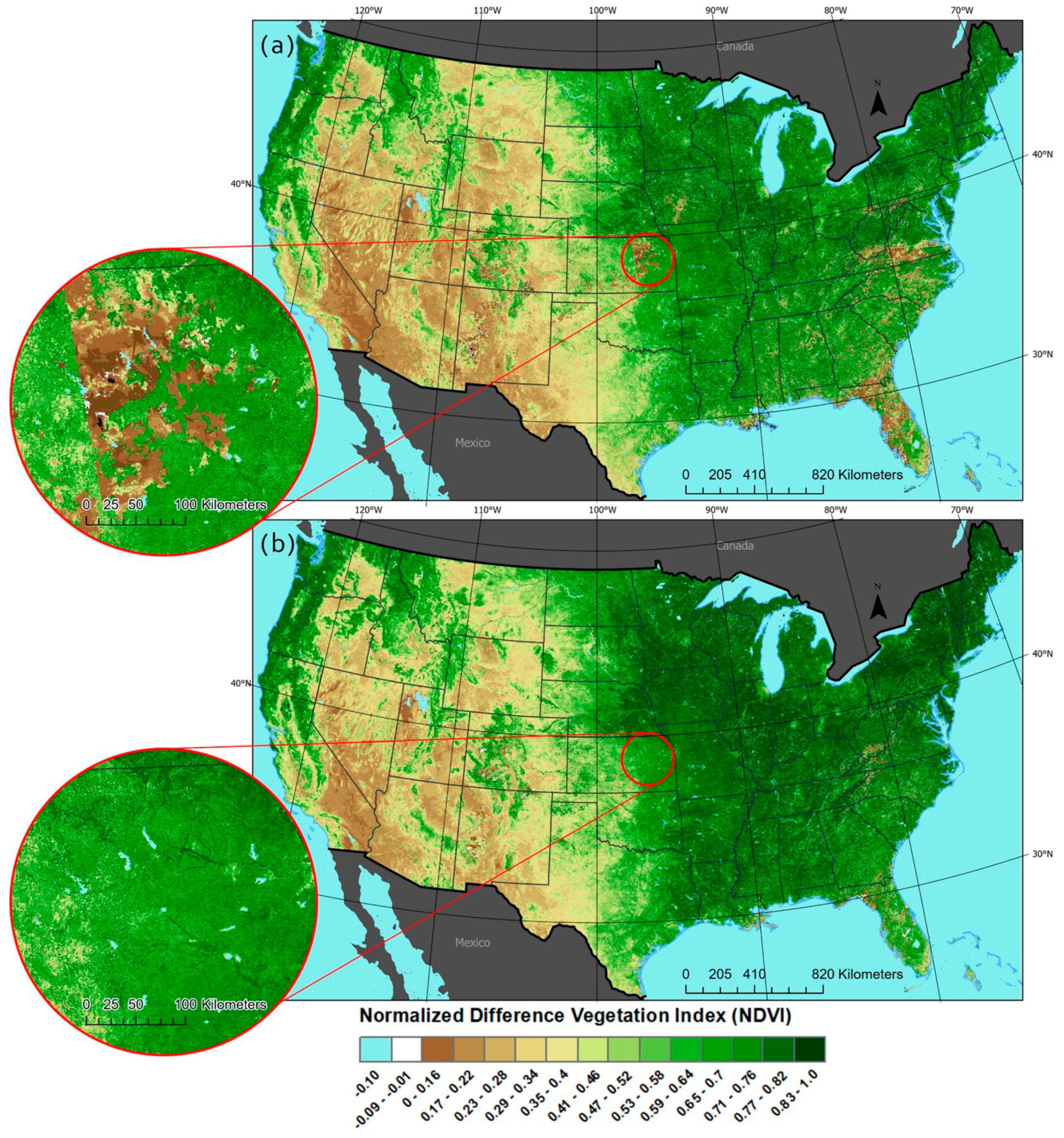
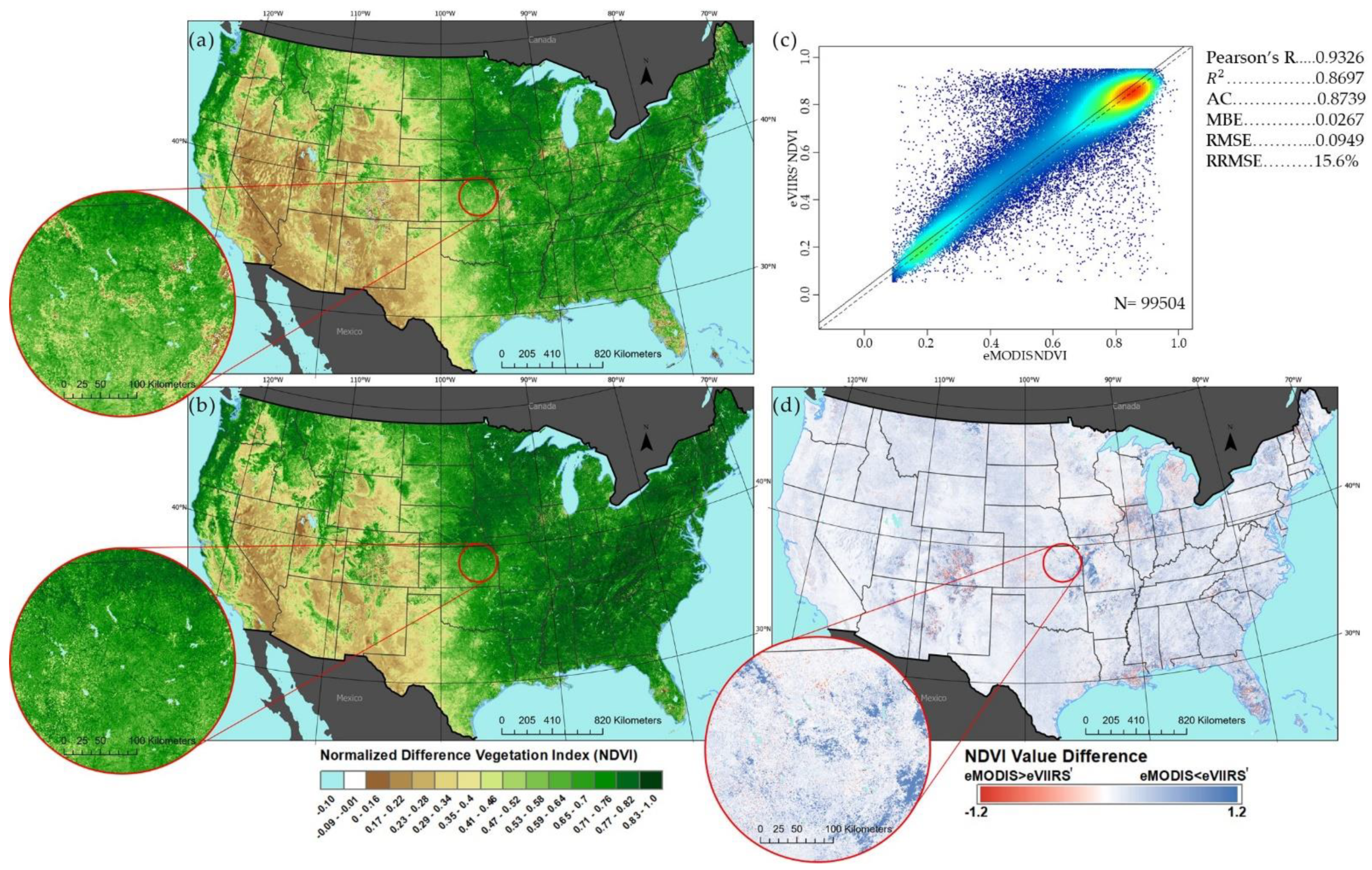
3.1. NDVI Transformation

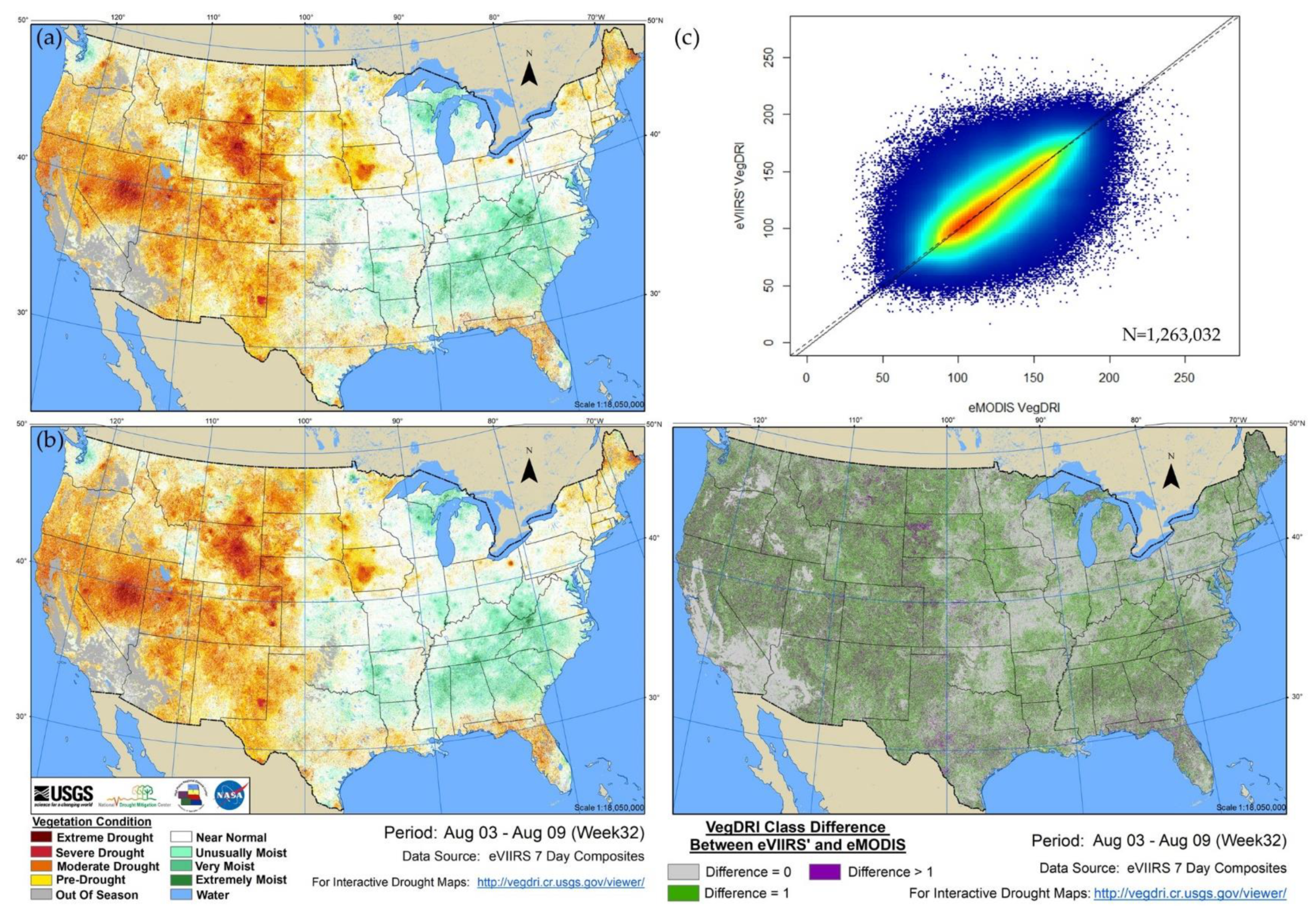
3.2. Vegetaion Anomaly Results
4. Discussion
4.1. NDVI Comparison
4.2. VegDRI Comparison
5. Conclusions
Author Contributions
Funding
Institutional Review Board Statement
Informed Consent Statement
Data Availability Statement
Acknowledgments
Conflicts of Interest
References
- Brown, J.F.; Wardlow, B.D.; Tadesse, T.; Hayes, M.J.; Reed, B.C. The Vegetation Drought Response Index (VegDRI): A new integrated approach for monitoring drought stress in vegetation. GIScience Remote Sens. 2008, 45, 16–46. [Google Scholar] [CrossRef]
- Littell, J.S.; Peterson, D.L.; Riley, K.L.; Liu, Y.; Luce, C.H. (Eds.) Fire and Drought; U.S. Department of Agriculture, Forest Service, Washington Office: Washington, DC, USA, 2016.
- Tadesse, T.; Demisse, G.B.; Zaitchik, B.; Dinku, T. Satellite-based hybrid drought monitoring tool for prediction of vegetation condition in Eastern Africa: A case study for Ethiopia. Water Resour. Res. 2014, 50, 2176–2190. [Google Scholar] [CrossRef]
- Svoboda, M.; LeComte, D.; Hayes, M.; Heim, R.; Gleason, K.; Angel, J.; Rippey, B.; Tinker, R.; Palecki, M.; Stooksbury, D.; et al. The drought monitor. Bull. Am. Meteorol. Soc. 2002, 83, 1181–1190. [Google Scholar] [CrossRef]
- Fuchs, B.A. National Drought Mitigation Center; University of Nebraska-Lincoln: Lincoln, NE, USA, 2021. [Google Scholar]
- Brown, J.F.; Howard, D.; Wylie, B.; Frieze, A.; Ji, L.; Gacke, C. Application-ready expedited MODIS data for operational land surface monitoring of vegetation condition. Remote Sens. 2015, 7, 16226–16240. [Google Scholar] [CrossRef]
- Jenkerson, C.B.; Maiersperger, T.; Schmidt, G. eMODIS: A User-Friendly Data Source: U.S. Geological Survey Open-File Report 2010–1055; U.S. Geological Survey EROS Center: Sioux Falls, SD, USA, 2010; p. 10. [CrossRef]
- Wylie, B.K.; Zhang, L.; Bliss, N.; Ji, L.; Tieszen, L.L.; Jolly, W.M. Integrating modelling and remote sensing to identify ecosystem performance anomalies in the boreal forest, Yukon River Basin, Alaska. Int. J. Digit. Earth 2008, 1, 196–220. [Google Scholar] [CrossRef]
- Boyte, S.P.; Wylie, B.K.; Major, D.J. Mapping and monitoring cheatgrass dieoff in rangelands of the Northern Great Basin, USA. Rangel. Ecol. Manag. 2015, 68, 18–28. [Google Scholar] [CrossRef]
- Rigge, M.; Wylie, B.K.; Gu, Y.; Belnap, J.; Phuyal, K.; Tieszen, L.L. Monitoring the status of forests and rangelands in the western United States using ecosystem performance anomalies. Int. J. Remote Sens. 2013, 34, 4049–4068. [Google Scholar] [CrossRef]
- Gulácsi, A.; Kovács, F. Drought monitoring of forest vegetation using MODIS-based normalized difference drought index in Hungary. Hung. Geogr. Bull. 2018, 67, 29–42. [Google Scholar] [CrossRef]
- Haroon, M.A.; Zhang, J.; Yao, F. Drought monitoring and performance evaluation of MODIS-based drought severity index (DSI) over Pakistan. Nat. Hazards 2016, 84, 1349–1366. [Google Scholar] [CrossRef]
- Hunt, E.R., Jr.; Ustin, S.L.; Riaño, D. Remote sensing of leaf, canopy, and vegetation water contents for satellite environmental data records. In Satellite-Based Applications on Climate Change; Springer: Dordrecht, The Netherlands, 2013; Volume 9789400758728, pp. 335–357. [Google Scholar]
- Nelson, K. Fire Danger Forecast—A Comparison of Fire Potential Index Rasters Derived from AVHRR and MODIS data. Available online: https://www.usgs.gov/ecosystems/lcsp/fire-danger-forecast/a-comparison-fire-potential-index-rasters-derived-avhrr-and (accessed on 2 January 2021).
- Becker-Reshef, I.; Vermote, E.; Lindeman, M.; Justice, C. A generalized regression-based model for forecasting winter wheat yields in Kansas and Ukraine using MODIS data. Remote Sens. Environ. 2010, 114, 1312–1323. [Google Scholar] [CrossRef]
- Johnson, D.M. A comprehensive assessment of the correlations between field crop yields and commonly used MODIS products. Int. J. Appl. Earth Obs. Geoinf. 2016, 52, 65–81. [Google Scholar] [CrossRef]
- Wang, D.; Morton, D.; Masek, J.; Wu, A.; Nagol, J.; Xiong, X.; Levy, R.; Vermote, E.; Wolfe, R. Impact of sensor degradation on the MODIS NDVI time series. Remote Sens. Environ. 2012, 119, 55–61. [Google Scholar] [CrossRef]
- Vermote, E.; Franch, B.; Claverie, M. VIIRS/NPP Surface Reflectance 8-Day L3 Global 500 m SIN Grid V001 [Dataset]. Available online: https://lpdaac.usgs.gov/products/vnp09h1v001/#using (accessed on 30 November 2020).
- Roger, J.C.; Vermote, E.F.; Devadiga, S.; Ray, J.P. Suomi-NPP VIIRS Surface Reflectance User’s Guide. Available online: https://viirsland.gsfc.nasa.gov/PDF/VIIRS_Surf_Refl_UserGuide_v1.3.pdf (accessed on 23 November 2020).
- Skakun, S.; Justice, C.O.; Vermote, E.; Roger, J.C. Transitioning from MODIS to VIIRS: An analysis of inter-consistency of NDVI data sets for agricultural monitoring. Int. J. Remote Sens. 2018, 39, 971–992. [Google Scholar] [CrossRef]
- Justice, C.O.; Román, M.O.; Csiszar, I.; Vermote, E.F.; Wolfe, R.E.; Hook, S.J.; Friedl, M.; Wang, Z.; Schaaf, C.B.; Miura, T.; et al. Land and cryosphere products from Suomi NPP VIIRS: Overview and status. J. Geophys. Res. Atmos. 2013, 118, 9753–9765. [Google Scholar] [CrossRef] [PubMed]
- Zhang, X.; Liu, L.; Liu, Y.; Jayavelu, S.; Wang, J.; Moon, M.; Henebry, G.M.; Friedl, M.A.; Schaaf, C.B. Generation and evaluation of the VIIRS land surface phenology product. Remote Sens. Environ. 2018, 216, 212–229. [Google Scholar] [CrossRef]
- Kogan, F.; Goldberg, M.; Schott, T.; Guo, W. Suomi NPP/VIIRS: Improving drought watch, crop loss prediction, and food security. Int. J. Remote Sens. 2015, 36, 5373–5383. [Google Scholar] [CrossRef]
- Ji, L.; Gallo, K.; Eidenshink, J.C.; Dwyer, J. Agreement evaluation of AVHRR and MODIS 16-day composite NDVI data sets. Int. J. Remote Sens. 2008, 29, 4839–4861. [Google Scholar] [CrossRef]
- Miura, T.; Turner, J.P.; Huete, A.R. Spectral Compatibility of the NDVI Across VIIRS, MODIS, and AVHRR: An Analysis of Atmospheric Effects Using EO-1 Hyperion. IEEE Trans. Geosci. Remote Sens. 2013, 51, 1349–1359. [Google Scholar] [CrossRef]
- Miura, T.; Muratsuchi, J.; Vargas, M. Assessment of cross-sensor vegetation index compatibility between VIIRS and MODIS using near-coincident observations. J. Appl. Remote Sens. 2018, 12. [Google Scholar] [CrossRef]
- Fan, X.; Liu, Y. A comparison of NDVI intercalibration methods. Int. J. Remote Sens. 2017, 38, 5273–5290. [Google Scholar] [CrossRef]
- Ricker, W.E. Computation and use of central lines. Can. J. Zool. 1984, 62, 1897–1905. [Google Scholar] [CrossRef]
- Laws, E.A.; Archie, J.W. Appropriate use of regression analysis in marine biology. Mar. Biol. 1981, 65, 13–16. [Google Scholar] [CrossRef]
- Ji, L.; Gallo, K. An agreement coefficient for image comparison. Photogramm. Eng. Remote Sens. 2006, 72, 823–833. [Google Scholar] [CrossRef]
- Ji, L.; Wylie, B.; Ramachandran, B.; Jenkerson, C. A comparative analysis of three different MODIS NDVI datasets for Alaska and adjacent Canada. Can. J. Remote Sens. 2010, 36, S149–S167. [Google Scholar] [CrossRef]
- Rouse, J.W., Jr.; Haas, R.H.; Schell, J.A.; Deering, D.W. Monitoring Vegetation Systems in the Great Plains with ERTS; NASA Special Publication: Washington, DC, USA, 1974; Volume 351. [Google Scholar]
- Jia, G.J.; Epstein, H.E.; Walker, D.A. Spatial heterogeneity of tundra vegetation response to recent temperature changes. Glob. Chang. Biol. 2006, 12, 42–55. [Google Scholar] [CrossRef]
- Despotovic, M.; Nedic, V.; Despotovic, D.; Cvetanovic, S. Evaluation of empirical models for predicting monthly mean horizontal diffuse solar radiation. Renew. Sustain. Energy Rev. 2016, 56, 246–260. [Google Scholar] [CrossRef]
- Li, M.F.; Tang, X.P.; Wu, W.; Liu, H.B. General models for estimating daily global solar radiation for different solar radiation zones in mainland China. Energy Convers. Manag. 2013, 70, 139–148. [Google Scholar] [CrossRef]
- Wolfe, R. Visible Infrared Imaging Radiometer Suite (VIIRS). Available online: https://ladsweb.modaps.eosdis.nasa.gov/missions-and-measurements/viirs/ (accessed on 29 January 2021).
- Matsushita, B.; Yang, W.; Chen, J.; Onda, Y.; Qiu, G. Sensitivity of the enhanced vegetation index (EVI) and normalized difference vegetation index (NDVI) to topographic effects: A case study in high-density cypress forest. Sensors 2007, 7, 2636–2651. [Google Scholar] [CrossRef] [PubMed]
- Brown, J.F.; Ji, L.; Gallant, A.; Kauffman, M. Exploring relationships of spring green-up to moisture and temperature across Wyoming, U.S.A. Int. J. Remote Sens. 2019, 40, 956–984. [Google Scholar] [CrossRef]
- Brown, J.F.; Pervez, M.S. Merging remote sensing data and national agricultural statistics to model change in irrigated agriculture. Agric. Syst. 2014, 127, 28–40. [Google Scholar] [CrossRef]
- Li, Z.; Shi, H.; Vogelmann, J.E.; Hawbaker, T.J.; Peterson, B. Assessment of fire fuel load dynamics in shrubland ecosystems in the western United States using MODIS products. Remote Sens. 2020, 12, 1911. [Google Scholar] [CrossRef]
- Boyte, S.P.; Wylie, B.K.; Major, D.J. Cheatgrass percent cover change: Comparing recent estimates to climate change—Driven predictions in the Northern Great Basin. Rangel. Ecol. Manag. 2016, 69, 265–279. [Google Scholar] [CrossRef]
- Funk, C.; Shukla, S.; Thiaw, W.M.; Rowland, J.; Hoell, A.; McNally, A.; Husak, G.; Novella, N.; Budde, M.; Peters-Lidard, C.; et al. Recognizing the famine early warning systems network over 30 years of drought early warning science advances and partnerships promoting global food security. Bull. Am. Meteorol. Soc. 2019, 100, 1011–1027. [Google Scholar] [CrossRef]


| eVIIRS vs. eMODIS eVIIRS’ vs. eMODIS | 2016 (375-m) | 2017 (375-m) | 2018 (375-m) | 2020 (375-m) | 2020 (1-km) | 2016–2018 (375-m) |
|---|---|---|---|---|---|---|
| Pearson’s R | 0.9390 | 0.9176 | 0.9171 | 0.9059 | 0.9162 | 0.9243 |
| 0.9391 | 0.9176 | 0.9171 | 0.9059 | 0.9162 | 0.9243 | |
| R2 | 0.8818 | 0.8419 | 0.8411 | 0.8206 | 0.8394 | 0.8543 |
| 0.8818 | 0.8419 | 0.8411 | 0.8206 | 0.8394 | 0.8543 | |
| AC | 0.8766 | 0.8471 | 0.8467 | 0.8255 | 0.8337 | 0.8570 |
| 0.8774 | 0.8296 | 0.8305 | 0.8236 | 0.8459 | 0.8415 | |
| MBE/Accuracy | 0.0506 | 0.0434 | 0.0434 | 0.0701 | 0.0786 | 0.0454 |
| 0.0051 | −0.0020 | −0.0035 | 0.0228 | 0.0312 | 0.0000 | |
| RMSE/Uncertainty | 0.0937 | 0.1028 | 0.1029 | 0.1318 | 0.1293 | 0.1000 |
| 0.0786 | 0.0926 | 0.0934 | 0.1107 | 0.1067 | 0.0886 | |
| RRMSE (%) | 20.3513 | 22.3428 | 22.8878 | 21.8264 | 21.7363 | 21.8790 |
| 17.0683 | 20.1326 | 20.7917 | 18.7904 | 17.9322 | 19.3747 |
| eVIIRS’ vs. eMODIS VegDRI | Week 29 | Week 30 | Week 31 | Week 32 1 | Weeks 29–32 |
|---|---|---|---|---|---|
| Pearson’s R | 0.6522 | 0.6492 | 0.6612 | 0.6857 | 0.6631 |
| R2 | 0.4254 | 0.4214 | 0.4371 | 0.4702 | 0.4397 |
| AC | 0.1389 | 0.1318 | 0.1703 | 0.2455 | 0.1752 |
| MBE/Accuracy | −0.0501 | −0.0794 | −0.1369 | −0.2238 | −0.1223 |
| RMSE/Uncertainty | 22.7448 | 22.9173 | 23.2202 | 23.0702 | 22.9742 |
| RRMSE (%) | 18.1620 | 18.1265 | 18.2916 | 18.4921 | 18.2676 |
Publisher’s Note: MDPI stays neutral with regard to jurisdictional claims in published maps and institutional affiliations. |
© 2021 by the authors. Licensee MDPI, Basel, Switzerland. This article is an open access article distributed under the terms and conditions of the Creative Commons Attribution (CC BY) license (http://creativecommons.org/licenses/by/4.0/).
Share and Cite
Benedict, T.D.; Brown, J.F.; Boyte, S.P.; Howard, D.M.; Fuchs, B.A.; Wardlow, B.D.; Tadesse, T.; Evenson, K.A. Exploring VIIRS Continuity with MODIS in an Expedited Capability for Monitoring Drought-Related Vegetation Conditions. Remote Sens. 2021, 13, 1210. https://doi.org/10.3390/rs13061210
Benedict TD, Brown JF, Boyte SP, Howard DM, Fuchs BA, Wardlow BD, Tadesse T, Evenson KA. Exploring VIIRS Continuity with MODIS in an Expedited Capability for Monitoring Drought-Related Vegetation Conditions. Remote Sensing. 2021; 13(6):1210. https://doi.org/10.3390/rs13061210
Chicago/Turabian StyleBenedict, Trenton D., Jesslyn F. Brown, Stephen P. Boyte, Daniel M. Howard, Brian A. Fuchs, Brian D. Wardlow, Tsegaye Tadesse, and Kirk A. Evenson. 2021. "Exploring VIIRS Continuity with MODIS in an Expedited Capability for Monitoring Drought-Related Vegetation Conditions" Remote Sensing 13, no. 6: 1210. https://doi.org/10.3390/rs13061210
APA StyleBenedict, T. D., Brown, J. F., Boyte, S. P., Howard, D. M., Fuchs, B. A., Wardlow, B. D., Tadesse, T., & Evenson, K. A. (2021). Exploring VIIRS Continuity with MODIS in an Expedited Capability for Monitoring Drought-Related Vegetation Conditions. Remote Sensing, 13(6), 1210. https://doi.org/10.3390/rs13061210


