Abstract
The variations and dynamics of suspended sediment in the coastal waters around the Zhoushan Archipelago are complex due to strong tidal dynamics. This study aims to delineate the tide-induced variability of surface suspended sediment and reveal its mechanisms in the Zhoushan Archipelago based on Geostationary Ocean Color Imager (GOCI) data. Suspended sediment concentration (SSC) estimations through the ultraviolet wavelength atmospheric correction (UV-AC) algorithm and a tuned empirical inversion algorithm using extensive in situ measurements are presented. GOCI-processed remote sensing reflectance (Rrs) is validated using field data and is cross-validated with Landsat 8 Operational Land Imager (L8/OLI) measurements, respectively. The estimated SSC is validated with independent datasets. The validations reveal that GOCI-processed Rrs is reasonable and that the GOCI-retrieved SSC is accurate and can be used to quantify SSC distributions and variations in the Zhoushan Archipelago. The variations of the SSC in the study area are closely related to the temporal variations of the tidal level. High SSCs often occur in the middle of ebb or flood tides due to large tidal discharge and high tidal velocity. Significant hourly variations of the SSC are mainly controlled by tidal forces. Dynamic mechanism analysis indicates that during neap and middle tides, the local high SSC is mainly attributed to the sediment resuspension process driven by tidal currents; in addition, during the spring tide, the variations of the SSC are simultaneously modulated by sediment resuspension and horizontal advection processes.
1. Introduction
Estuaries and coastal waters are the key areas for interactions between land and sea and have various physical and ecological processes, which are often characterized by high suspended sediment concentrations (SSCs) due to tides, waves, river runoff, eddies, seasonal winds, coastal currents, and human activities [1,2,3]. The significant diurnal and seasonal variations of the SSC have an important influence on marine ecology, marine chemistry, water quality, the sedimentary environment, estuarine topographical evolution, and the carbon cycle [4,5,6,7,8]. Suspended sediment transport in coastal areas has become a common concern in related disciplines. Therefore, it is of great practical significance to fully understand the variations of suspended sediment transport and its dynamic mechanisms, which are key to understanding sedimentary processes in estuarine and coastal waters.
The Zhoushan Archipelago, which is located in the southern Yangtze River Estuary and the eastern Hangzhou Bay and directly connects to the open sea, is the main way for Yangtze River waters to flow southward as well as for the main channel for Hangzhou Bay waters to exchange with East China Sea waters [9,10]. With complex coastlines, numerous islands, narrow channels, and rugged undersea terrain, the Zhoushan Archipelago is one of the most complex geographical environments in the East China Sea/Pacific Ocean and has a significant influence on the variations of suspended sediment [11]. The Zhoushan Archipelago is dominated by typical semidiurnal tides [12,13], which present high-velocity shear, strong advection, and significant nonlinearity [14]. The tides are characterized by reciprocal currents, with flood tides going westward and ebb tides going eastward [15], and the tidal asymmetry is significant [13,16]. The sediment particles in the Zhoushan Archipelago are mainly fine cohesive sediments, which are easily suspended in water [17,18]. In addition, due to the complex hydrodynamics and the existence of numerous islands, the spatial distribution and temporal variations of suspended sediment in this area are extremely complicated and should garner attention.
Based on field data, the transport mechanisms of suspended sediments were investigated in the Zhoushan Archipelago and the results showed that advection transport and gravitational circulation transport were the primary dynamic factors in suspended sediment transport [9]. Based on a two-dimensional (2D) tidal current and suspended sediment model, the suspended sediment transport in the Luotou Channel was studied, and the results indicated that there was a good correlation between the SSC and the flood and ebb current processes, and that advective sediment transport was the major driver of sediment transport in the channel [19]. Using a 2D sediment transport model under the influence of waves and tidal currents, the hydrodynamics and sedimentation effects of deposition-promoting projects on the environment in the northern Daishan Sea area were investigated [13]. Based on remote sensing data with high resolution, the impacts of islands on the SSC in Zhoushan coastal waters were analyzed. The results indicated that the islands could influence the SSC by inducing Karman vortex streets [20]. However, traditional field investigations cannot monitor large temporal and spatial variations of SSCs, and some data are inconsistent due to different sampling times. Compered with field sampling and numerical modeling methods, satellite remote sensing data have been widely leveraged in SSC spatiotemporal distribution studies. Previous studies have indicated that satellite remote sensing methods could provide reliable and high spatiotemporal SSC observation data. However, due to the limitation of low temporal resolution, most satellites, such as the Sea-viewing Wide Field-of-view Sensor (SeaWiFS), Moderate Resolution Imaging Spectroradiometer (MODIS), Medium Resolution Imaging Spectrometer (MERIS), Coastal Zone Color Scanner (CZCS), and Landsat, are unable to capture the short-term variations of SSCs. Therefore, in this paper, the Geostationary Ocean Color Imager (GOCI), which is the world’s first ocean color sensor in geostationary orbit, has been chosen to study the short-term variations of the SSC due to its high temporal resolution. The GOCI has been used to monitor the hourly, diurnal, monthly, seasonal, and annual variations of suspended sediment in the estuaries and coastal waters of China, such as the Yalu River Estuary [21], Bohai Bay [22], the Yellow River estuary [23], the Yangtze River estuary [24], and Hangzhou Bay [1].
Previous works have demonstrated that SSC variations can be related to various factors, such as sediment discharge, wind, waves, tidal currents, bottom terrain, and human activities. However, due to limitations in the spatiotemporal resolution of observational data, there are scarce studies on the variation of suspended sediment over a tidal cycle in the Zhoushan Archipelago. A concrete description of the spatial pattern and tidal variation of suspended sediment is worth presenting, and the dynamic mechanisms of variations in suspended sediment warrant further investigation, especially in typical tidal cycles and in different regions; this is the motivation of this paper. For instance, which dynamic factor is more important in regulating the SSC variations, and which factor can be ignored? To address these questions, high-resolution spatiotemporal GOCI images are needed to map the short-term dynamics of surface SSCs in the Zhoushan Archipelago.
The rest of the paper is organized as follows. Section 2 presents the data and methods. The retrieval model is established and validated by combining a good deal of in situ measurements in Section 3. In Section 4, the tidal-induced variations of surface suspended sediment based on GOCI-retrieved datasets and the governing mechanisms by using the advection–diffusion equation of suspended sediment transport are studied and analyzed. Section 5 presents the conclusions of this paper.
2. Data and Methods
2.1. Study Area
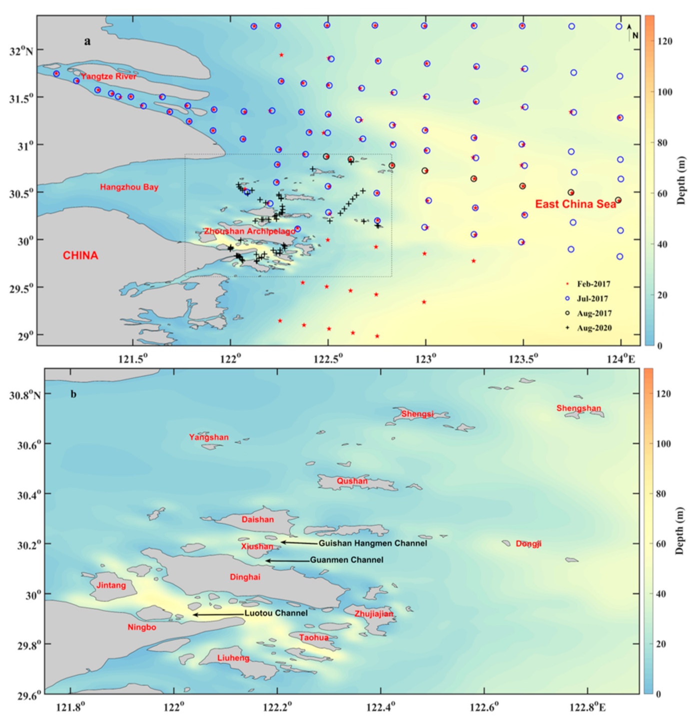
The Zhoushan Archipelago (121°30′–123°25′ E, 29°32′–31°04′ N) is the largest archipelagic area in China and contains 1390 islands and 3306 reefs of different shapes and sizes. The region is 182 km long from east to west, 169 km wide from north to south, and covers approximately 20,800 km2 of water and 1440.12 km2 of land. The islands in the south are larger and higher than those in the north. The Zhoushan Archipelago is located on the southeast coast of China, south of the Yangtze River Estuary, and east of Hangzhou Bay (Figure 1). The water depth in this area varies greatly. It ranges between 30 m in nearshore areas and more than 100 m in many narrow channels between islands [14]. The Zhoushan Archipelago is characterized by a strong semidiurnal tidal current [25]. The tidal current is rotary over the shelf region but is rectilinear inside the channels due to the restriction of complex coastlines [26]. The observed average tidal ranges are 1.9–3.3 m, and tidal currents between islands can be up to 4 m/s [14]. Previous studies have indicated that the tidal asymmetry in the Zhoushan Archipelago is significant, and the mean flow velocity of ebb tide is slightly greater than that of flood tide, especially in several channels, such as the Guanmen Channel and Guishan Hangmen Channel [14,16,27]. The Zhoushan Archipelago is surrounded by the sea and dominated by a subtropical monsoon climate: northerly winds prevail in winter, but southerly winds are predominant in summer. The wind speed in this area varies greatly with multi-year averages of 3.5 to 4.5 m/s, and the mean and maximum wave heights are 0.5 and 6.1 m, respectively [28]. Yangtze River and Qiantang River sediments are transported into Hangzhou Bay and dispersed toward the Zhoushan Archipelago, which induces high SSCs [29]. The surface SSC of the region ranges from 2 to 1481 mg/L [9]. The Zhoushan Archipelago is suitable for the reproduction and growth of various biological communities, which provides quite favorable conditions for fishery production [30]. It is vulnerable to tropical storms (typhoons) during summer and autumn, and strong winds due to cold front events often occur in winter. Detailed information on the study area and the sampling points are shown in Figure 1.
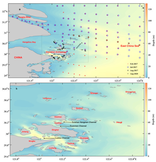
Figure 1.
(a) Geographic location of the Zhoushan Archipelago and locations of the sampling stations during four cruises (Feb-2017, Jul-2017, Aug-2017, and Aug-2020). (b) Bathymetry map of the study area.
2.2. Field Data and SSC Measurements
The cruises for field data collection were conducted in August 2020. A total of 61 seawater samples were collected during the daytime (generally from 8:00 am to 4:00 pm, local time). Following NASA SIMBIOS ocean optic protocols [31], the remote sensing reflectance (Rrs) was synchronously measured using an Analytical Spectral Devices (ASD) handheld spectrometer with a spectral range of 325–1075 nm. To avoid ship shadows and sun-glint contamination, a viewing zenith angle of approximately 40° and a relative azimuth angle of 135° were used (referring to solar orientation), respectively [32]. An integration time was chosen according to the incident radiance intensity, and the dark current was corrected each time when the integration time was changed. Three optical parameters, the reference radiance (Lg), sky radiance (Lsky), and total surface reflectance (Rt), were measured. Each of them was measured 10 times at each station, and the median value was used to calculate Rrs. The calculation equation used is as follows:
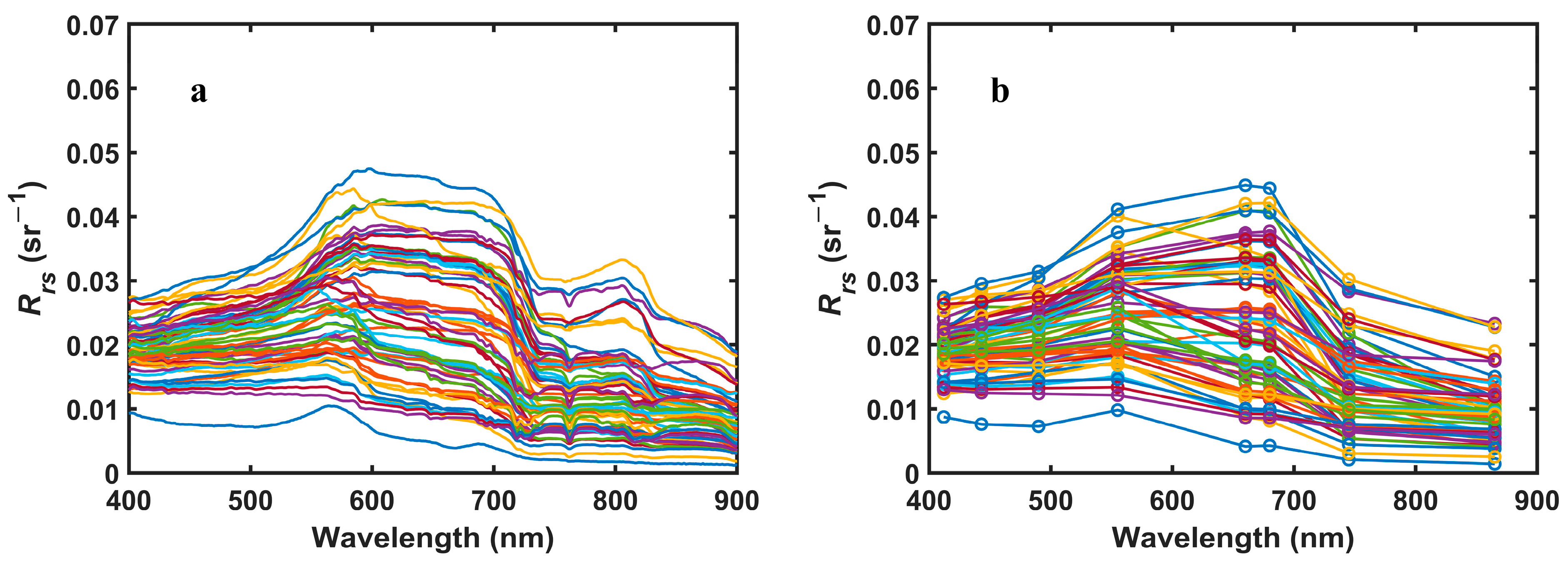
where ρ is the air–sea interface reflectance varying from 0.022 to 0.05. ρ is influenced by the sky conditions, sea-surface roughness, and viewing and illumination geometries. In this study, ρ was set to 0.028 [32]. Figure 2 shows the measured Rrs spectrum in the Zhoushan Archipelago.
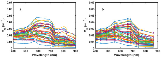
Figure 2.
(a) The measured remote sensing reflectance (Rrs) spectrum of the Zhoushan Archipelago. (b) The spectrum of the measured Rrs corresponding to the Geostationary Ocean Color Imager (GOCI) bands.
In the laboratory, blank filters (0.45 μm pore size) were placed in a drying oven and dried for eight hours at 40 °C. After cooling, the blank filters were weighed on an electronic analytical scale with an accuracy of 0.0001 g and then placed in numbered filter boxes. Then, 500 mL of surface seawater samples was recorded, and the extraction rate of the vacuum pump was used to drain the filters. To remove the dissolved salts, the filters were rinsed with 20 mL distilled water three times. Filters were dried in a drying oven for 24 h at 40 °C. After the samples cooled down, the filters were reweighed by an electronic analytical scale to obtain the SSC [23,33].
The other three cruises for field data collection were conducted in 2017, which covered the Yangtze River estuary, the Zhoushan Archipelago, and their adjacent sea areas. Only seawater samples were collected, and the laboratory analysis procedure was similar to the previous procedure. The data were used as independent data to verify the accuracy of the SSC inversion algorithm in Section 3.
2.3. Remote Sensing Data
GOCI Level-1B data were downloaded from the South Korean Ocean Satellite Center (KOSC) website (http://kosc.kiost.ac.kr/ accessed on 22 January 2021). The GOCI was launched by the KOSC in 2010 and it is approximately 35,786 km above the equator. The observation center of the GOCI sensor is at 130° E and 26° N. The observation area is approximately 2500 km × 2500 km (116.08° E–143.92° E, 24.75° N–47.25° N), and comprises 16 (4 × 4) slot images. The range of GOCI spectral measurements covers visible light to near-infrared light, with a total of eight wavelength bands (412, 443, 490, 555, 660, 680, 745, and 865 nm). The GOCI has a spatial resolution of 500 m and a temporal resolution of 1 h, and it collects eight scenes per day (8:28 am to 3:28 am, local time) [34]. Three cloud-free or low cloud coverage days were selected to study the variations of the SSC under tidal actions in the Zhoushan Archipelago: 13 August 2020 (neap tide), 16 August 2020 (middle tide), and 20 August 2020 (spring tide). A total of 24 scene images were obtained.
In addition, Landsat 8 Operational Land Imager (L8/OLI) data was downloaded from the United States Geological Survey (USGS, https://earthexplorer.usgs.gov/ accessed on 22 January 2021), which was used to propose cross-validation between GOCI and L8/OLI Rrs estimates. The dark spectrum fitting (DSF) atmospheric correction algorithm, which has been proved to be suitable for the nearshore turbidity water by field data, was used to estimate Rrs for L8/OLI. Atmospheric correction processing was implemented via ACOLITE software (available at https://odnature.naturalsciences.be/remsem/software-and-data/acolite accessed on 22 January 2021), which was developed by the Royal Belgian Institute of Natural Sciences [35].
2.4. Modeling Hydrodynamic Data
The modeling results of tidal currents and tidal elevations using a fine-tuning finite volume community ocean model (FVCOM) were applied to evaluate the relationships between SSC variations and tides and investigate the dynamic mechanisms of suspended sediment transport. The study domain of the tuned model covers the Bohai Sea, the Yellow Sea, and the East China Sea with a resolution smaller than 500 m for the present study area. The model was validated by water level and current observations, which indicated that the model was able to reproduce the tidal dynamics in the study area. Details about the validations and settings of the model can be found in previous studies [36].
2.5. Accuracy Assessment
In this study, three statistical parameters, including the mean relative error (MRE), root mean square error (RMSE), and correlation coefficient (R2), were used to measure the errors:
where X and Y represent the in situ and satellite-estimated Rrs or SSC, respectively. Smaller values of MRE and RMSE, and a larger absolute value of R2 (|R2|) show a better agreement for both datasets. |R2| is classified as no correlation (|R2| < 0.3), low correlation (0.3 < |R2| < 0.5), moderate correlation (0.5 < R2 < 0.8), and high correlation (|R2| > 0.8).
3. Retrieval Model Establishment and Validation
3.1. Atmospheric Correction Processing and Validation
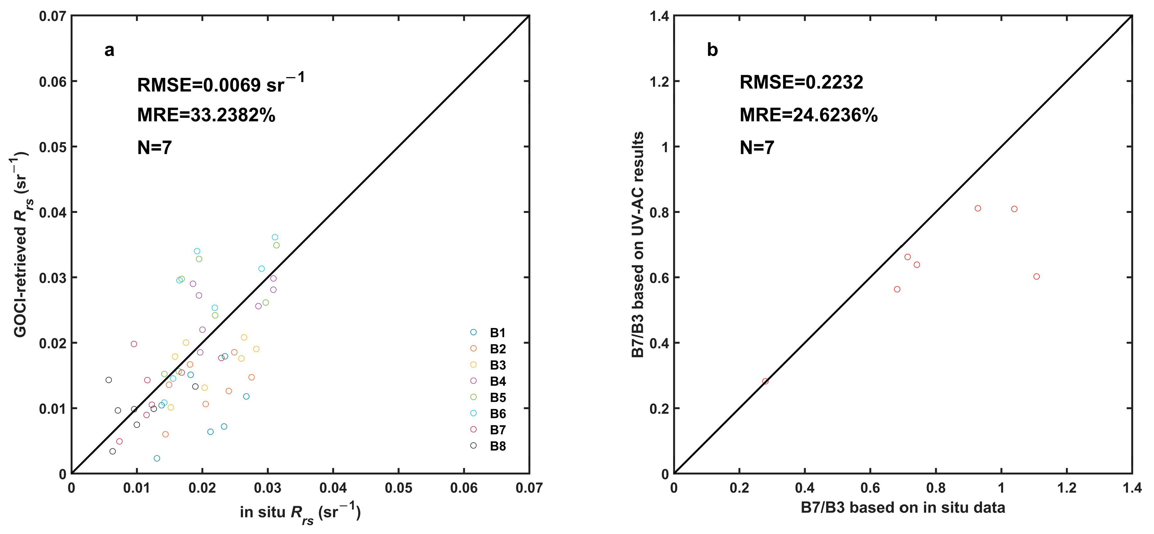
Previous studies have verified that the ultraviolet wavelength atmospheric correction (UV-AC) algorithm is suitable for high turbidity water near the shore using measured data [1,2,37,38]. In this paper, we compared the GOCI-derived Rrs against in situ observations in the Zhoushan Archipelago by following the criteria for matching satellite data and in situ observations in previous studies [38] The data of seven stations were obtained to validate the UV-AC algorithm. Figure 3a shows that the Rrs derived from the UV-AC algorithm was consistent with the in situ measured results. The RMSE and MRE of the eight GOCI bands were 0.0069 sr−1 and 33.2382%, respectively. Previous studies found a good linear relationship between B7/B3 and the SSC on a logarithmic scale in the Yangtze River Estuary and Hangzhou Bay [1]. In this manuscript, the band ratio was used to calculate the SSC. The seven stations were used to verify the accuracy of the band ratio. Figure 3b shows that the band ratio of B7/B3 derived from the UV-AC was consistent with in situ measurements, with the RMSE and MRE of B7/B3 being 0.2232 and 24.6236%, respectively. The above results indicated that GOCI Rrs data processed by the UV-AC method are reasonable.
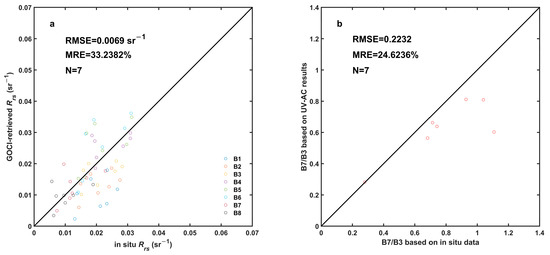
Figure 3.
Comparison of Rrs (a) and Rrs (B7)/Rrs (B3) (b) between in situ measurements and data derived from the ultraviolet wavelength atmospheric correction (UV-AC) algorithm.
Furthermore, to validate the accuracy of the spatial distribution of Rrs, a validation of GOCI Rrs was proposed based on cross-validations with L8/OLI measurements in the Zhoushan Archipelago. The cross-validation method has been widely used to verify the accuracy of retrieved Rrs from different satellites. For example, TM/ETM+ measured Rrs was cross-validated with MODIS measurements, which showed that TM/ETM+ could provide reasonable Rrs and be used to quantify the long-term variations of the SSC in the Yellow River Estuary [39]. The L8/OLI measured Rrs was validated with MODIS measurements in the Yellow River Estuary, and the results revealed that the distributions of the two derived Rrs were consistent [33]. Cross-comparisons of Rrs derived from three high spatial resolution sensors (L8/OLI, Sentinel-2A/MSI, and GF-1/WFV) in the Yangtze Estuary were conducted. The results indicated that Rrs data from high-resolution sensors were consistent with GOCI data, especially at the red spectral ranges [40]. The GOCI has a lower spatial resolution but a higher revisiting frequency, and Landsat-8 has a higher spatial resolution but a lower revisit frequency. Therefore, the spatial distribution and variation of GOCI-derived Rrs can be validated by L8/OLI. Furthermore, the transit time of L8/OLI (10:30 am) is close to that of the GOCI (10:28 am). Therefore, cross-validation is convincing, which can help examine the consistency among multi-source satellite products and allow for the production of merged multi-source high-resolution satellite products with high-frequency time series in the future.
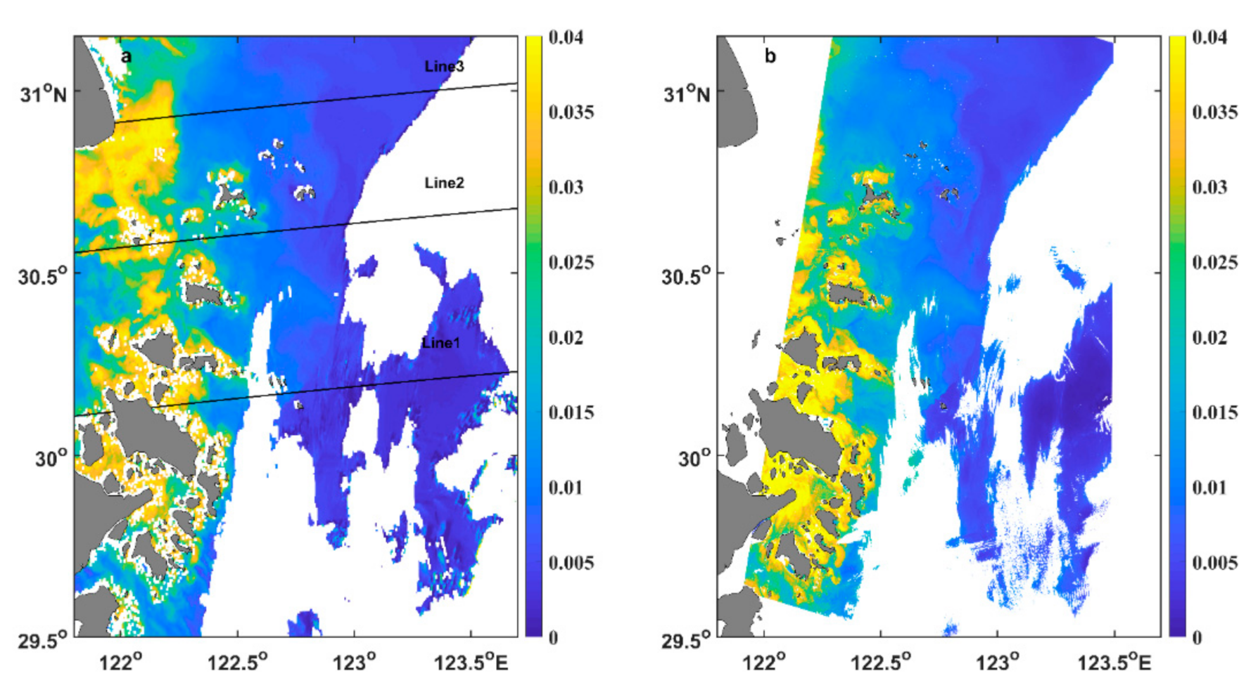
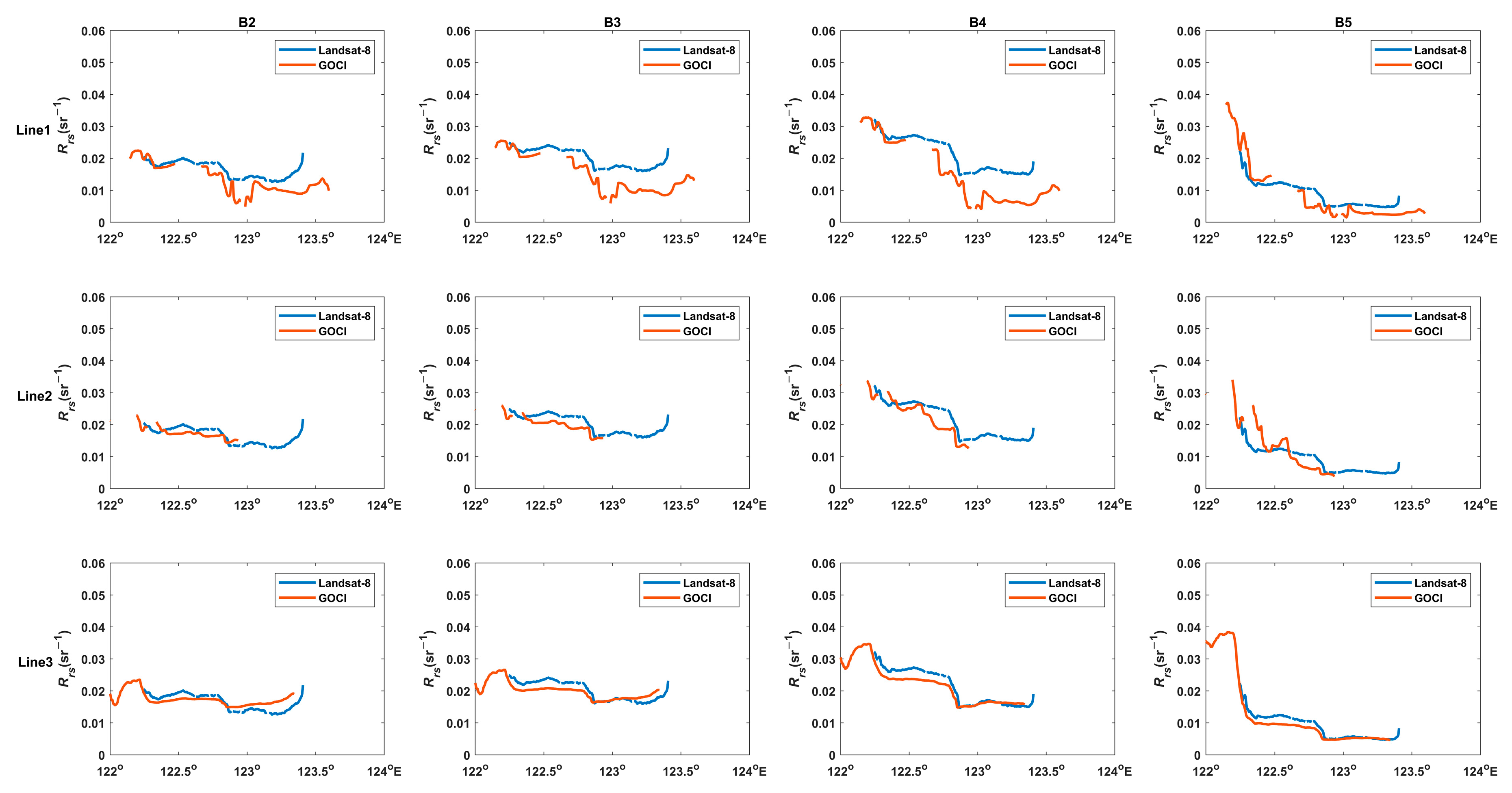
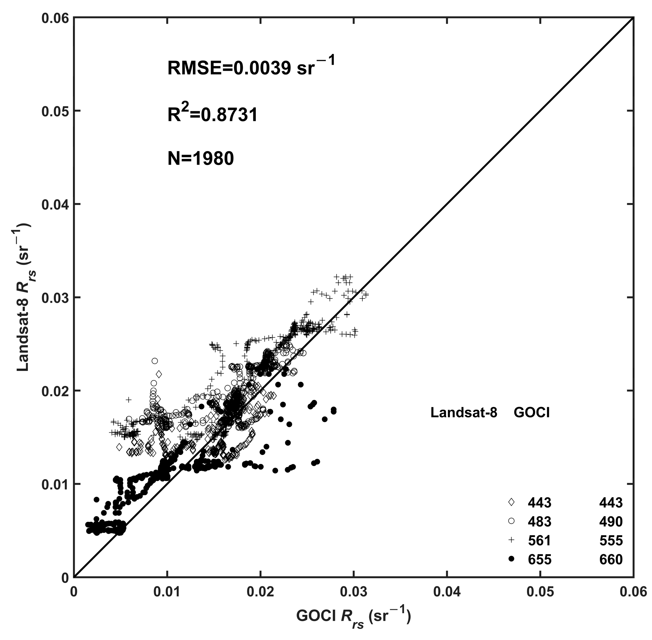
Figure 4 displays a comparison between GOCI-derived Rrs (660) and L8/OLI-derived Rrs (655). The spatial distributions of the two derived Rrs were highly consistent. High values were found near the islands and showed a rapidly decreasing trend from nearshore to offshore. To further verify the consistency of spatial variations of Rrs, three typical transects were selected (Figure 5). The spatial variation trends of the two Rrs were consistent, especially in the coastal waters. However, there was inconsistency in some areas. The difference may be the result of the signal-to-noise ratio with an obvious signal decrease and various atmospheric correction algorithms, and the differences of the spatial resolution between the two satellite sensors cannot be completely eliminated. In addition, the difference was probably attributable to various sensor designs, spectral settings, and radiometric quality [33,40]. Figure 6 shows that the GOCI-measured Rrs and L8/OLI measurements were closely distributed along the 1:1 line, with the RMSE and R2 being 0.0039 mg/L and 0.8731, respectively. Accordingly, the UV-AC algorithm is suitable for high turbidity waters in the Zhoushan Archipelago, and the derived Rrs can be used to establish the SSC inversion model.
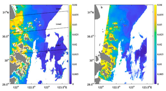
Figure 4.
GOCI-derived Rrs (660) (a) versus Landsat 8 Operational Land Imager (L8/OLI)-derived Rrs (655) (b). The white areas represent cloud coverage or missing data. Three transects (marked as line1, line2, and line3) were used for the cross-validation between GOCI-retrieved Rrs and L8/OLI measurements.
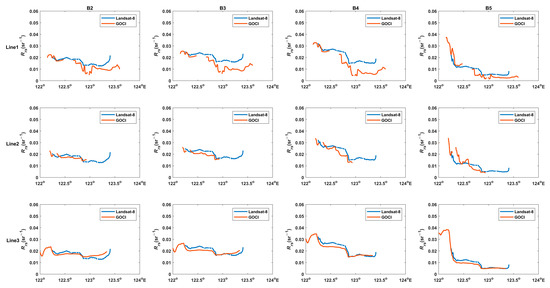
Figure 5.
Comparisons between GOCI-derived Rrs and L8/OLI-derived Rrs along three lines. Four bands (the units are nm) are given from left to right: B2 (GOCI Rrs (443) versus L8/OLI Rrs (443)); B3 (GOCI Rrs (490) versus L8/OLI Rrs (483)); B4 (GOCI Rrs (555) versus L8/OLI Rrs (561)); and B5 (GOCI Rrs (660) versus L8/OLI Rrs (655)). Three transects from top to bottom, line1, line2, and line3, are shown in Figure 4.
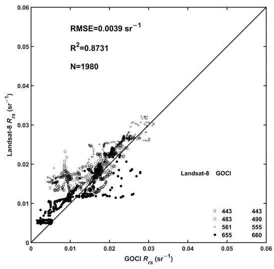
Figure 6.
GOCI-retrieved Rrs versus L8/OLI measurements.
3.2. SSC Retrieval Method
In this paper, the applicability of an SSC inversion algorithm [1] in the Zhoushan Archipelago was further assessed, and the empirical coefficients in the algorithm were tuned. Thus, the tuned empirical SSC inversion algorithm was more suitable for Zhoushan Archipelago seawater. Furthermore, to verify the robustness of the tuned algorithm, its accuracy was validated by three independent datasets measured during the wet and dry seasons in 2017.
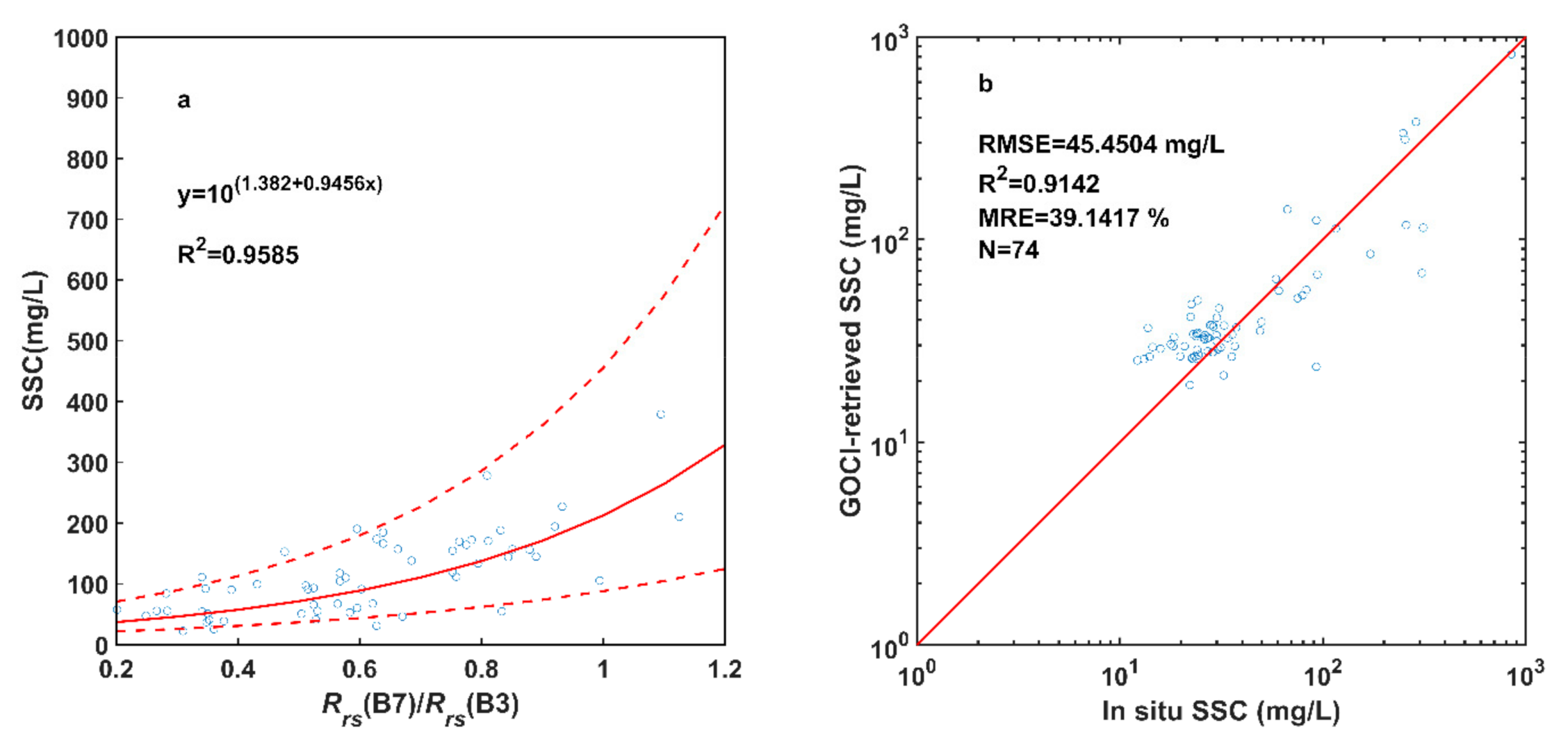
The measured SSC during cruises in August of 2020 ranged from 27.7008 to 384.058 mg/L. The 61 pairs of in situ and satellite data were used for the tuning algorithm, and the independent datasets were used to evaluate the algorithm errors. The tuned algorithm is as follows:
Figure 7 shows the tuned empirical SSC model using B7/B3 and the accuracy of the tuned algorithm verified by using the independent datasets. The time window of the satellite overpass and field measurements was 1 hour. Removing the influence of cloud coverage, a total of 74 in situ data with corresponding GOCI-retrieved SSCs were obtained. The results showed that the RMSE, R2, and MRE were 45.4504 mg/L, 0.9142, and 39.1417%, respectively, which indicated that the tuned SSC retrieved model was suitable for both wet and dry seasons in the Zhoushan Archipelago.
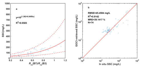
Figure 7.
(a) The tuned empirical suspended sediment concentration (SSC) model using B7/B3. The red solid line is the fitting result, and the red dotted line represents the 95% confidence interval. (b) Scatter plots of comparisons between the GOCI-retrieved SSC and in situ observations measured in 2017. The red straight line represents the 1:1 line.
4. Results and Analysis
4.1. Spatial Distributions of the SSC
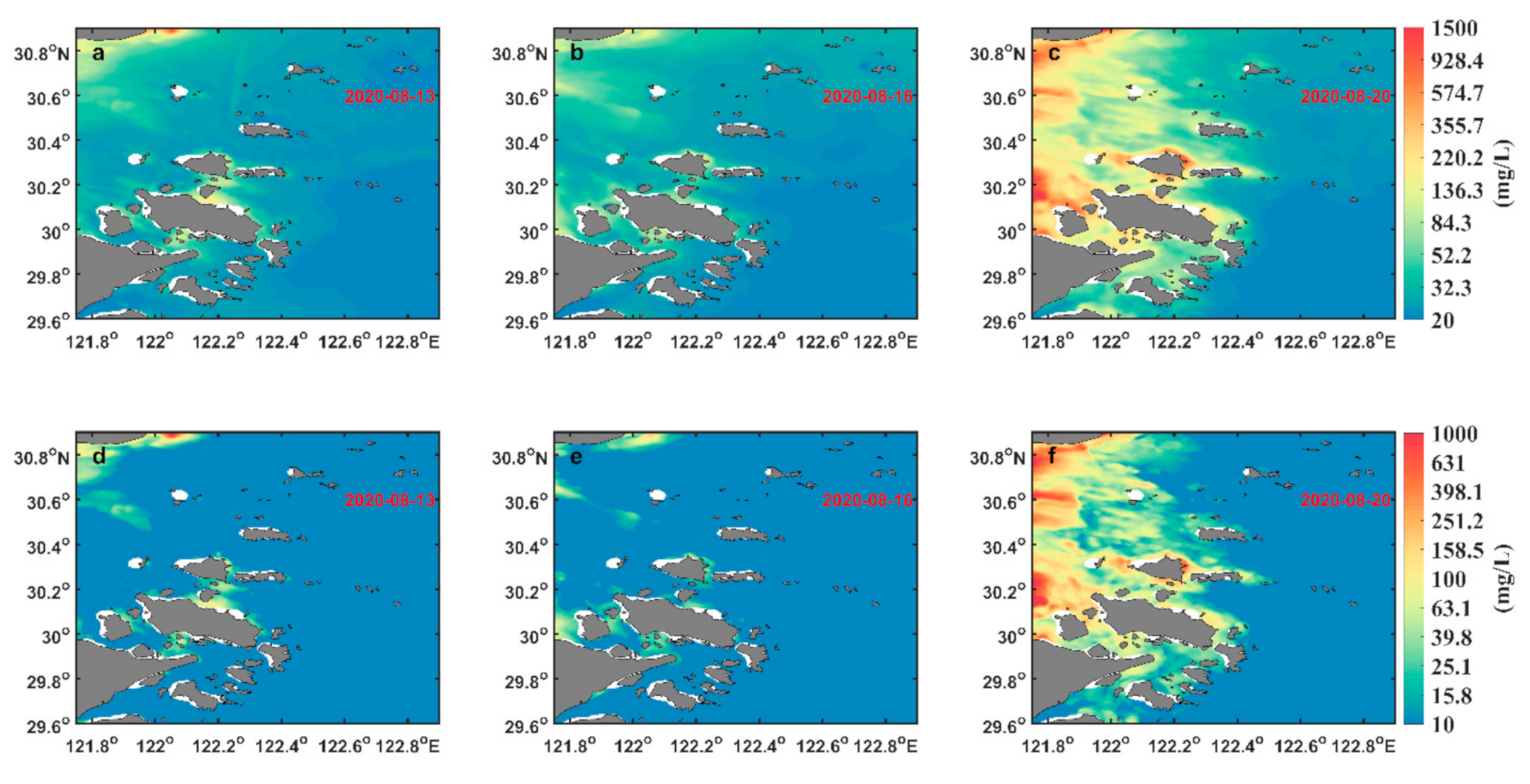
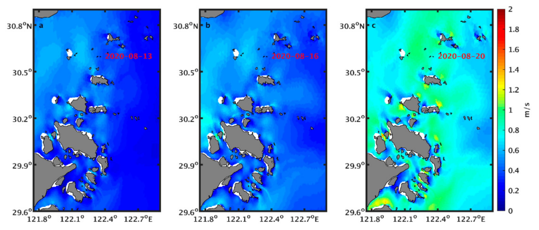
Based on hourly GOCI-retrieved SSC images in the Zhoushan Archipelago during the neap tide, middle tide, and spring tide, the daily averaged SSC and corresponding standard deviation (STD) were obtained to study the spatial distributions of the SSC under the three tidal types. Figure 8 shows that the SSC in the nearshore waters was higher and became lower in the offshore waters. High SSCs were mainly found in the channels between the islands. Due to the barrier effect of islands and intrusion of clear seawaters, the SSC in the western part of the study area was generally higher than that in the eastern part. During the spring tide, the magnitude of currents was more than twice those of the neap and middle tides (Figure 9); thus, the SSC in the western part was higher. The spatial distributions of the STD were similar to those of the daily SSC, which indicated that the regions with a high SSC were also the regions with large SSC fluctuations. The STD in nearshore waters was much greater than that in the outer sea for each tidal type. This phenomenon was more obvious during the spring tide period (Figure 8c,f). The STD during spring tide was significantly higher than that in the neap and middle tide periods. Previous studies found that the SSC increases with increasing current speed [27,29]. High current speeds enhanced the resuspension of sediments in the water, and suspended sediments were synchronously transported by horizontal advection currents. Consequently, dominated by the resuspension and horizontal advection processes of sediments, the variation of the SSC during spring tide was much more significant than that during the other two tidal types.
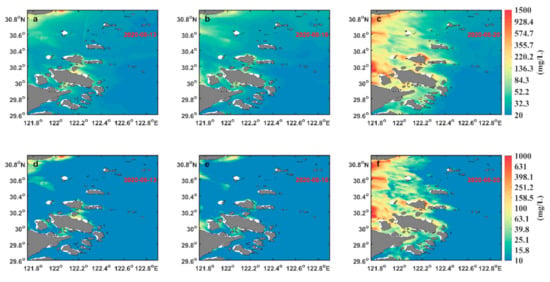
Figure 8.
The daily averaged SSC during neap (a), middle (b), and spring tides (c), respectively. (d–f) show the corresponding standard deviation (STD).
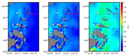
Figure 9.
Temporally averaged surface velocities from the simulated results corresponding to the daily averaged SSC during neap (a), middle (b), and spring tides (c).
4.2. Short-Term Variations of the SSC
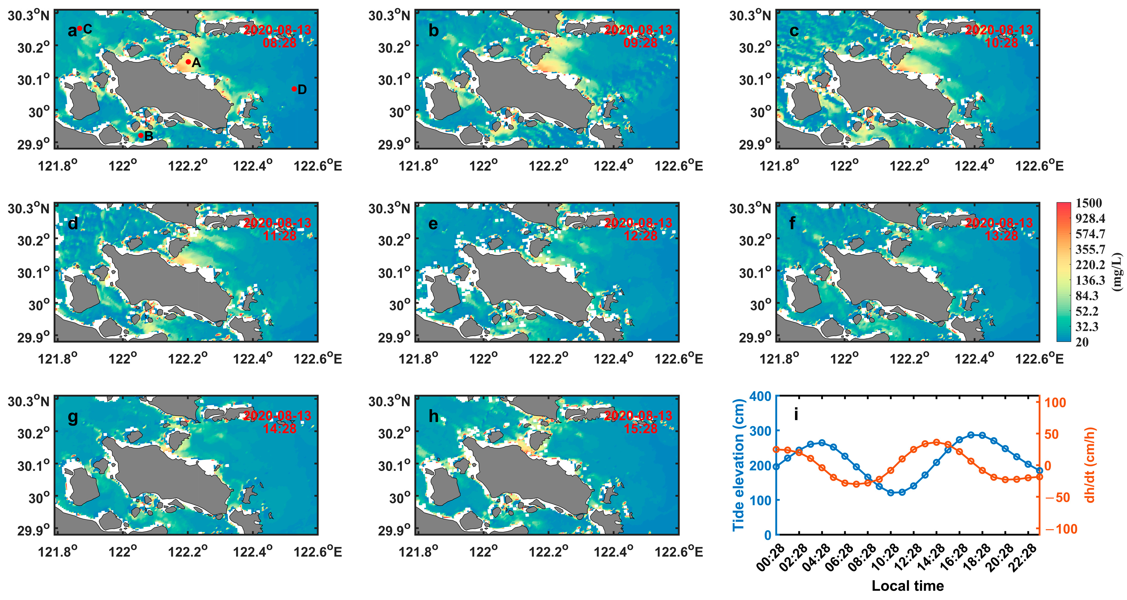
Hourly GOCI-retrieved SSC images during the three tidal cycles were obtained to investigate the short-term variations of the SSC under different tidal conditions. The results are shown in Figure 10, Figure 11 and Figure 12. In addition, four typical points A, B, C, and D (the red dots in Figure 10a) were selected to study the tidal variations of the SSC. Point A was located in the eastern side of the Guanmen Channel. Point B was located in the Luotou Channel. Points C and D were located in the western and eastern sides of the Zhoushan Archipelago, respectively. The variations of the SSC at the four points are shown in Figure 13. Previous studies indicated that tidal effects, sediment discharge, and wind are the main factors related to SSC variations [33,38]. In the study area, the tides were considered the dominant mechanisms for the temporal and spatial variations of the SSC because the wind and sediment discharge remained relatively stable and did not change significantly under the three tidal cycles. The tide elevation data simulated by FVCOM were obtained to investigate the effect of tidal changes on surface suspended sediment. In general, when tidal discharge reaches its maximum, current velocities are synchronously high, resulting in a high bottom shear stress and sediment resuspension rate, which increases the surface SSC [41]. Therefore, the temporal variation of the tidal level, dh/dt, is used as the estimation of tidal discharge, with positive and negative values representing flood and ebb directions, respectively [41,42]. This approximation is based on the tub model of Boon [43], which can be written as
where Q is the tidal discharge; A is the area inside the system, which is considered to be a constant [41]; and dh/dt indicates the variation of the tidal level.
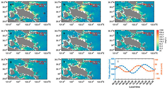
Figure 10.
(a–h) Hourly maps of the GOCI-retrieved SSC in the Zhoushan Archipelago during neap tide on 13 August 2020. The red dots in (a) are the selected points for the analysis. (i) The simulated hourly tide elevation and temporal variation of tidal level, dh/dt, at point A.
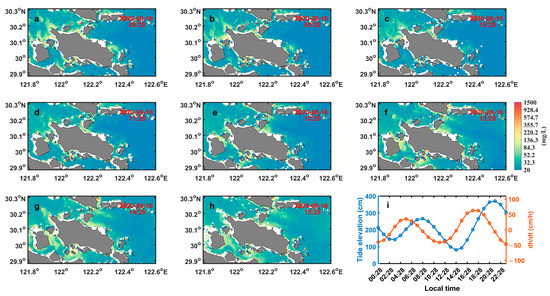
Figure 11.
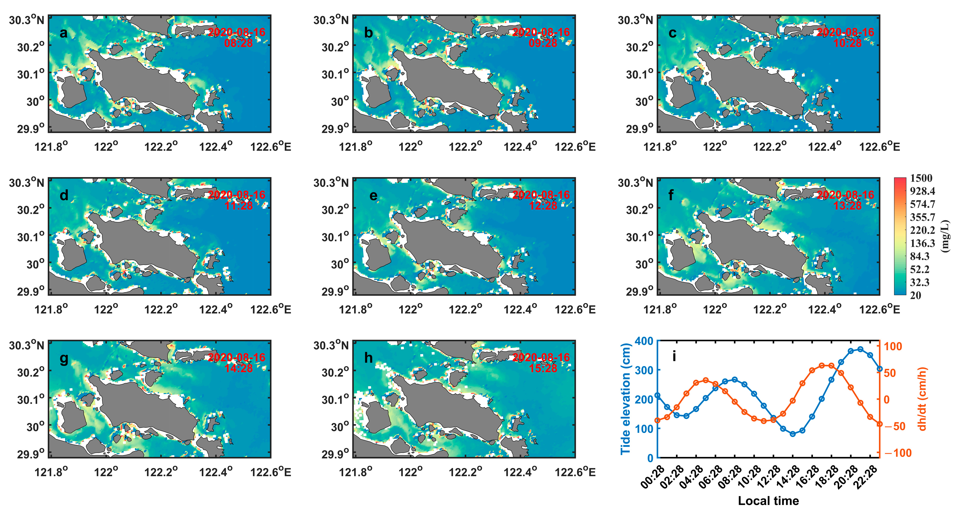
Same as Figure 10 but for the middle tide on 16 August 2020.
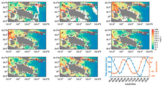
Figure 12.
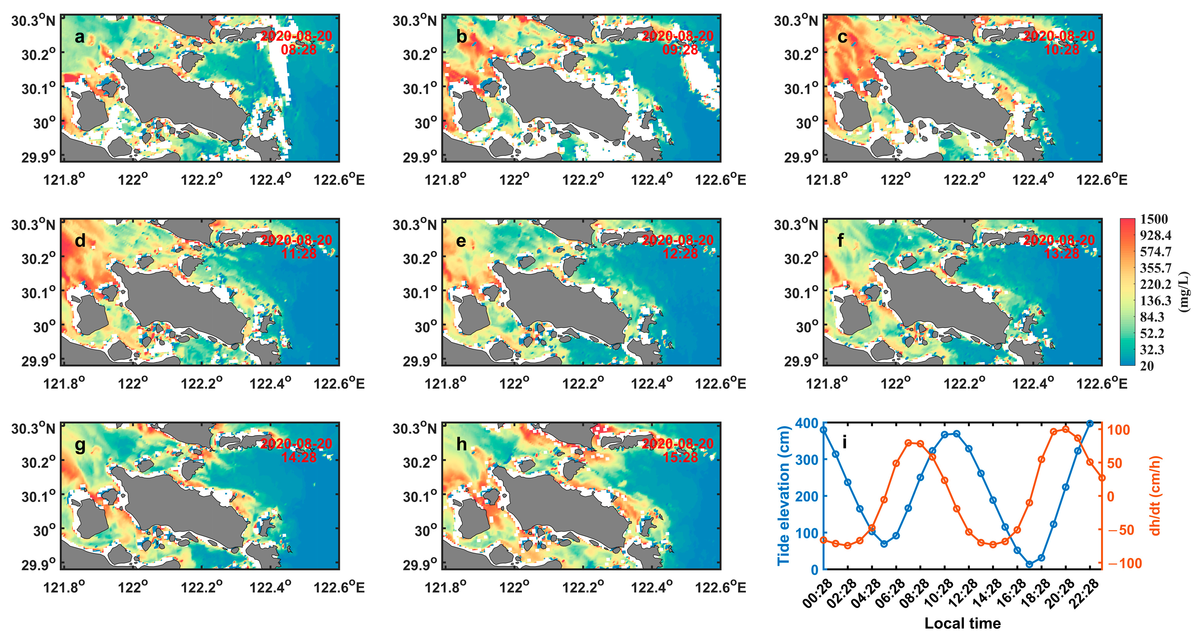
Same as Figure 10 but for the spring tide on 20 August 2020.

Figure 13.
The variations of the SSC at four typical points during neap (a), middle (b), and spring (c) tides, respectively. The SSC was calculated by averaging over a box of 5 × 5 pixels (2 km × 2 km) centered on the selected points.
During the neap tide (13 August 2020), the satellite transit time was from the middle of ebb tide to the middle of flood tide. The ebb and flood processes can be clearly identified from the hourly GOCI-retrieved SSC images (Figure 10), especially in the Guanmen Channel and Guishan Hangmen Channel. During ebb tide, two turbidity zones formed on the eastern side of the two channels, which extended approximately 15 km (Figure 10c). During flood tide, suspended sediment tended to be transported westward, forming a turbidity belt of approximately 8 km (Figure 10h). The range of the turbidity zone was significantly smaller than that during ebb tide, which could be related to the tidal asymmetry in the study area. Due to the strait-channel effect, the current velocities in the two channels were strong with a pattern of reversing currents. Thus, the advection and resuspension of sediments might be strong. Modeling results [14] and field observations [44] confirmed that jetlike flow is one of the typical features in these channels. The jetlike flow during ebb tide is stronger than that during flood tide because the existence of Xiushan Island impedes the flood current but has little influence on the ebb current, and the ebb-dominant tide forms here [14]. Consequently, the suspended sediment shows a sea-ward transport trend, which can also be identified from the hourly GOCI-retrieved SSC images (Figure 7). In addition, rapid changes in the water level can lead to higher tidal current velocities, and strong horizontal and vertical shears of tidal current flows can enhance the mixing of water and the resuspension of bottom sediment, resulting in a significant increase in the surface SSC. From Figure 13a, during ebb tide, a high dh/dt corresponded to a high SSC at 8:28 am at point A. Subsequently, the SSC decreased with dh/dt. During flood tide, a high dh/dt contributed to bottom sediment resuspension, but at the same time, the eastern flux of relatively clean water from the open sea reduced the surface SSC in the study area. Thus, the surface SSC only increased by 6.53 mg/L at 2:28 pm. Previous studies have indicated that the suspended sediment in the Zhoushan Archipelago mainly originated from Hangzhou Bay and the Yangtze River Estuary [11,29,45]. However, during the neap tide period, due to the weak tidal current, suspended sediment was mostly deposited in Hangzhou Bay and the Yangtze River Estuary and was hard to transport to the Zhoushan Archipelago. Therefore, the variations of the SSC at points C and D were not significant. In the Luotou Channel, the SSC also increased rapidly during the middle of ebb tide and reached its high level at low slack tide.
During the middle tide (16 August 2020), the satellite transit time was from the start of ebb tide to the start of flood tide (Figure 8). The imaging time covered a relatively complete ebb tide. The start time of ebb was close to 8:28 am, at which time the surface SSC of the study area reached its minimum value due to a low dh/dt. During the period from 10:28 am to 12:28 pm, due to the rapid increase of dh/dt, the resuspension of sediment was strengthened, resulting in a rapid increase of the surface SSC in the Guanmen Channel and Guishan Hangmen Channel. Subsequently, tidal current velocity decreased, and the deposition of sediments prevailed, leading to a decrease of the surface SSC. In the Luotou Channel, the SSC also increased significantly due to a high dh/dt and reached its peak at low slack tide.
During the spring tide (20 August 2020), the imaging time of the GOCI was from the middle of flood tide to the middle of ebb tide, which covered a tidal cycle containing a flood tide of 3 h and an ebb tide of 4 h. As shown in Figure 9, the SSC was clearly higher than that in the neap and middle tides. From Figure 9i, during the middle of flood tide, dh/dt reached 0.79 and 0.78 m/h at 7:28 am and 8:28 am, respectively. Then, the surface SSC reached its maximum at 9:28 am and decreased as dh/dt decreased in most regions. During the middle of ebb tide, dh/dt again reached nearly 0.70 m/h at 1:28 pm, and the surface SSC increased rapidly, reaching its maximum at 3:28 pm. It should be noted that the variation of the SSC had a lag of approximately 2 h relative to dh/dt. This phenomenon could be attributed to the fact that it took a certain amount of time for the bottom sediment to resuspend and diffuse to the surface through vertical mixing, and the lag time was closely related to the intensity of tidal mixing and the water depth [46,47].
4.3. Discussion on the Governing Mechanism
To explore the dynamic mechanism of the tidal variation of the SSC in the Zhoushan Archipelago, the advection–diffusion equation of suspended sediment was employed to quantitatively estimate the magnitude and relative importance of horizontal and vertical terms on the temporal variations of suspended sediment [47]:
where C is the SSC; t is the time; V represents the horizontal tidal velocity components u and v; u′, v′, and C′ denote anomalies of u, v, and C; and G is the diffusion flux vector in the horizontal direction. The terms from left to right in Equation (7) are the local change (CHA), the horizontal advection (ADV), the horizontal diffusion (DIF), and all the other terms related to the vertical direction (VER), including the vertical convection term, vertical diffusion term, and settling term.
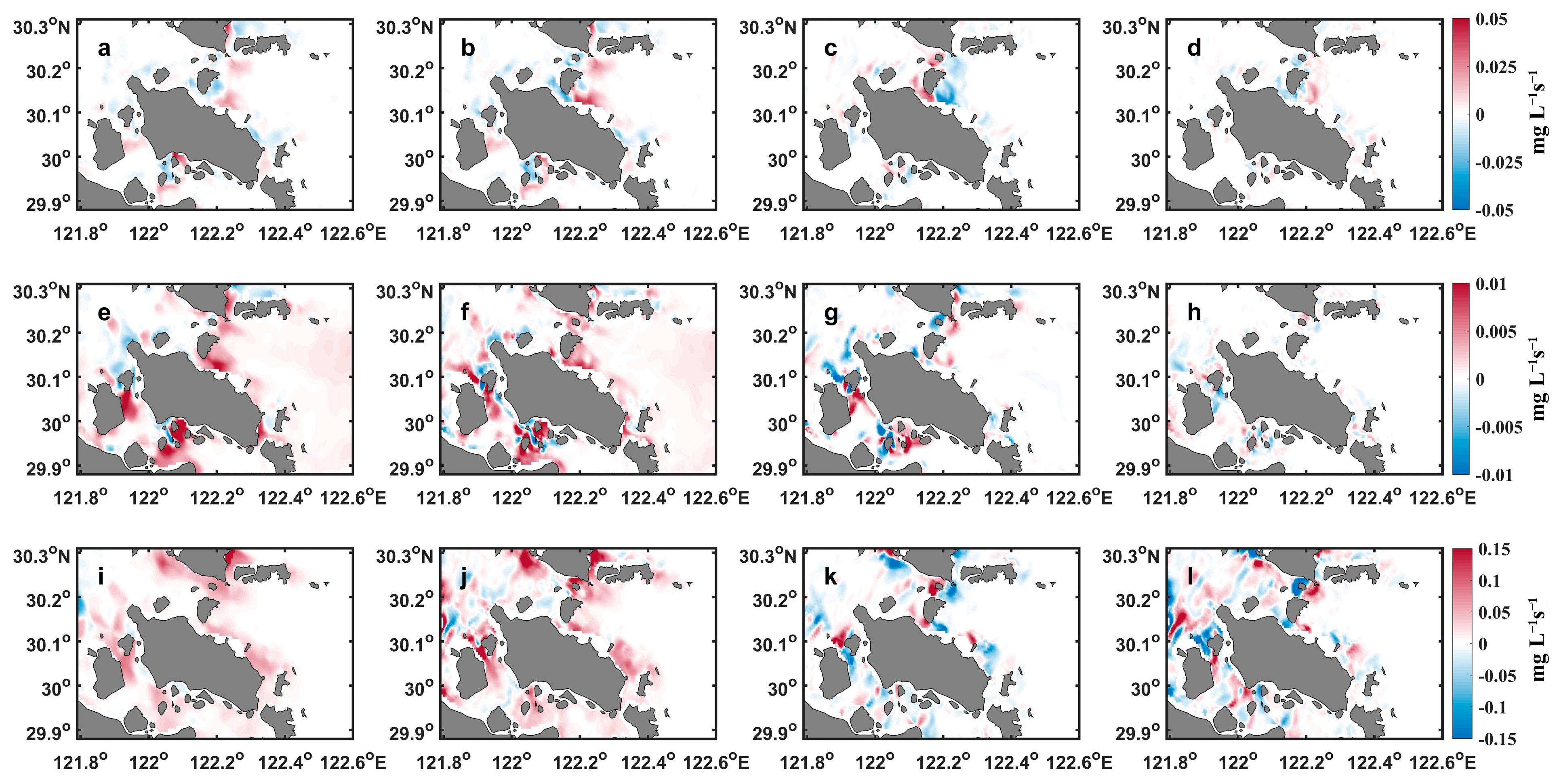
As described in Section 4.2, interesting phenomena in this study are the large SSC values in the Guanmen Channel and Guishan Hangmen Channel during the neap and middle tides (Figure 7 and Figure 8). Therefore, the middle times of the ebb tides from 8:28 am to 9:28 am on 13 August 2020 and 11:28 am to 12:28 pm on 16 August 2020 were selected to clarify this issue. The spatial distributions of the four terms are shown in Figure 14a–h. Compared with the CHA in the SSC, the contribution of the ADV and DIF in most of the Zhoushan Archipelago was basically negligible, except for the areas close to the islands (Figure 14c,d,g,h). The results strongly indicated that the VER played a dominant role in the tidal variation of the SSC during the middle of the ebb tide. During spring tide, the middle time of ebb tide from 1:28 pm to 2:28 pm was selected to study the dynamic mechanism of the tidal variations in SSCs. The spatial distributions of the four terms are shown in Figure 14i–l. The order of the four terms is similar (10−2 mg L−1 s−1). The results indicated that the variations of SSCs were modulated by bottom sediment resuspension and horizontal advection processes during spring tide.
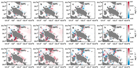
Figure 14.
The spatial distributions of the local change (CHA, a), all terms related to the vertical direction (VER, b), the horizontal advection (ADV, c), and the horizontal diffusion (DIF, d) from 08:28 am to 09:28 am on 13 August 2020. (e–h) and (i–l) are the same as (a–d) but for the spatial distributions of the four terms from 11:28 am to 12:28 pm on 16 August 2020 and 1:28 pm to 2:28 pm on 20 August 2020, respectively.
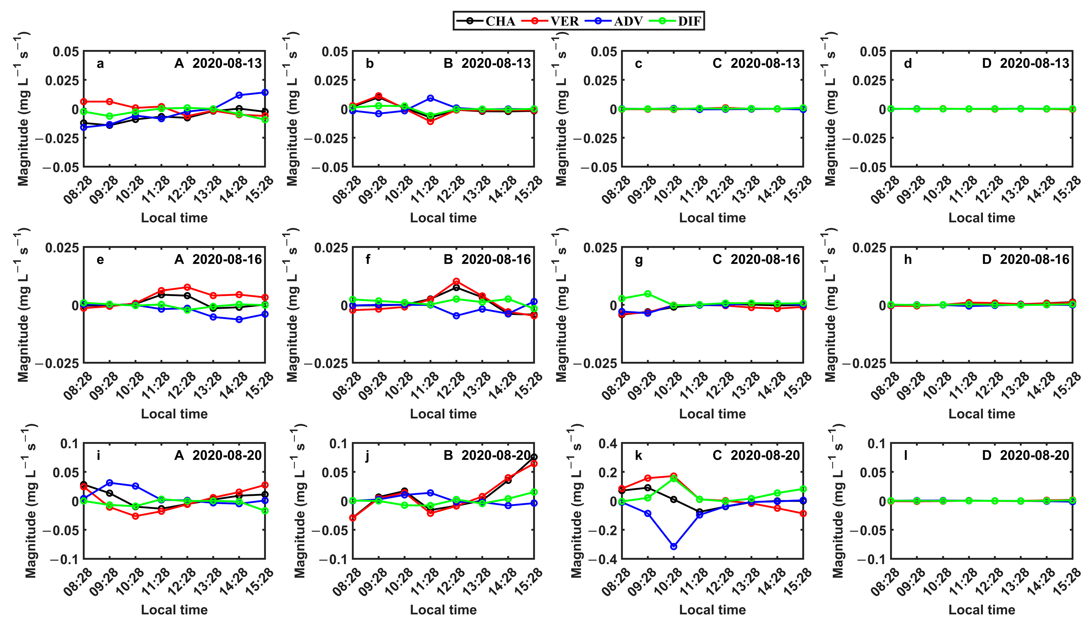
To further study the dynamic mechanism of the tidal variations of the SSC in the Zhoushan Archipelago, the four typical points A, B, C, and D were selected. As shown in Figure 15, during the neap and middle tides, the high surface SSC in the Guanmen Channel was mainly caused by the bottom sediment resuspension. In the Luotou Channel, the variation of the SSC was modulated by the ADV and VER. The variations of the SSC on the eastern and western sides of the Zhoushan Archipelago were not obvious due to weak tidal currents. During spring tide, the variations of the SSC in the Guanmen Channel, Luotou Channel, and the regions on the western side of the Zhoushan Archipelago were mainly controlled by the ADV and VER. The DIF was a secondary factor for the variations of the SSC. On the eastern side of the Zhoushan Archipelago, due to the deep water depth, the sediment rapidly settled near the shore, and the variation of the SSC in the region was not significant.
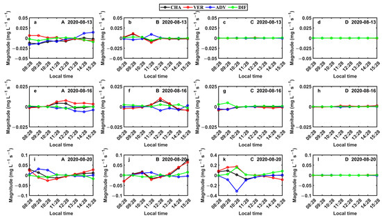
Figure 15.
(a–d) are the variations of the four terms (local change (CHA), vertical direction (VER), horizontal advection (ADV), and horizontal diffusion (DIF)) at the four typical points A, B, C, and D during the neap tide, respectively. (e–h) and (i–l) are the same as (a–d) but for the middle and spring tides, respectively.
Based on the above analysis, the general pattern for the variations of the SSC in the Zhoushan Archipelago can be summarized over typical tidal cycles, as follows:
- (1)
- During the neap and middle tides, the SSC often increases rapidly in the middle of ebb tide because stronger tidal currents enhance vertical mixing and the resuspension of bottom sediments (Figure 7a). However, in the middle of flood tide, the suspended sediment shows landward movement (Figure 7g), which may be attributed to horizontal sediment advection [3,48]. The minimum value of the SSC appears approximately 1.0–1.5 h after high slack water. The local high SSCs in the Guanmen Channel and Guishan Hangmen Channel during ebb tide are controlled by a tidal resuspension process of bed sediments.
- (2)
- During the spring tide, the SSC shows a pattern with two peaks, corresponding to the middle of ebb and flood tides, respectively, which is different from that during neap and middle tides. The range of dh/dt is more than two times those during the neap and middle tides, and the current velocities are larger. During both ebb tide and flood tide, the resuspension of bottom sediments and horizontal advection become the dominant factors that govern the variations of the SSC. Therefore, the variations of the SSC during the spring tide period are mainly controlled by bottom sediment resuspension and horizontal advection processes in most regions.
5. Conclusions
Using hourly GOCI-retrieved SSC images, the tidal-induced variations and governing mechanisms of surface-suspended sediment in the Zhoushan Archipelago were studied. GOCI-processed Rrs using the UV-AC algorithm was validated and cross-validated with field measurements and L8/OLI measurements, respectively, and the tuned SSC inversion algorithm was validated with in situ data. The results showed that the atmospheric correction algorithm and SSC inversion algorithm were suitable for mapping the tidal dynamics of the SSC in the Zhoushan Archipelago.
Based on the hourly GOCI-retrieved SSC images, the spatial distributions of the SSC had significant differences under different tidal types. Higher SSCs in terms of both range and intensity occurred during the spring tide than during the neap and middle tides due to stronger tidal dynamics. Combined with simulation results from FVCOM, the temporal variations of the SSC in the Zhoushan Archipelago were mainly controlled by the variations of the tidal level and tidal current velocity, especially for typical channels (Guanmen Channel and Guishan Hangmen Channel) with a typical jetlike flow feature.
Furthermore, the dynamic mechanism of the tidal variations of the SSC in the Zhoushan Archipelago was studied in detail. The results indicated that during the neap and middle tides, the high SSC in the Guanmen Channel and Guishan Hangmen Channel was mainly modulated by the resuspension of bottom sediment. The variations of the SSC in the Luotou Channel were mainly controlled by horizontal advection, while in most other regions, the SSC changes were not obvious. During spring tide, the variations of the SSC were controlled by horizontal advection and resuspension processes in most regions of the Zhoushan Archipelago.
Based on high-resolution remote sensing images, this study successfully captured the transport process of suspended sediment modulated by tides in the Zhoushan Archipelago, which provides a theoretical reference for port development, waterway maintenance, ecosystem restoration, and water quality monitoring in complex archipelagic waters. In addition to the Zhoushan Archipelago, our research can be applied to the studies of suspended sediment transport in other tidal-controlled archipelagic waters worldwide, thereby enhancing the ability to monitor variations of marine environments on a short time scale. Furthermore, this study refines the mechanisms of suspended sediment transport in the Zhoushan Archipelago during typical tidal cycles, which helps to assess the migration and sedimentary patterns of suspended sediment and predict the expansion and erosion of coastlines.
Author Contributions
Conceptualization, J.Z., Y.P.W.; Data Curation, Y.D., J.Z.; Funding acquisition: J.Z.; Investigation: Y.D., H.L.; Methodology: Y.D., H.L., S.H., and J.Z.; Project administration: J.Z.; Resources: J.Z., Y.P.W.; Supervision: J.Z.; Validation: Y.D.; Visualization: Y.D.; Writing—original draft: Y.D., S.H.; Writing—review and editing: D.W., J.Z., S.H. All authors have read and agreed to the published version of the manuscript.
Funding
This work was funded by the National Key Research and Development Program of China [grant numbers 2017YFA0604100 and 2017YFC1404000], the National Natural Science Foundation of China [grant numbers 41876086, 41625021, and 41876031], and the Guangdong Basic and Applied Basic Research Foundation [grant number 2020A1515110339].
Data Availability Statement
Not applicable.
Acknowledgments
We acknowledge the KOSC for providing the GOCI data, the USGS for providing the Landsat 8 OLI data, and the OD Nature Remote Sensing and Ecosystem Modeling (REMSEM) team of the Royal Belgian Institute of Natural Sciences for providing the ACOLITE software.
Conflicts of Interest
The authors declare no conflict of interest.
References
- He, X.; Bai, Y.; Pan, D.; Huang, N.; Dong, X.; Chen, J.; Chen, C.-T.A.; Cui, Q. Using geostationary satellite ocean color data to map the diurnal dynamics of suspended particulate matter in coastal waters. Remote Sens. Environ. 2013, 133, 225–239. [Google Scholar] [CrossRef]
- Liu, J.; Liu, J.; He, X.; Pan, D.; Bai, Y.; Zhu, F.; Chen, T.; Wang, Y. Diurnal dynamics and seasonal variations of total suspended particulate matter in highly turbid Hangzhou Bay waters based on the Geostationary Ocean Color Imager. IEEE J. Sel. Top. Appl. Earth Obs. Remote Sens. 2018, 11, 2170–2180. [Google Scholar] [CrossRef]
- Yang, X.; Mao, Z.; Huang, H.; Zhu, Q. Using GOCI retrieval data to initialize and validate a sediment transport model for monitoring diurnal variation of SSC in Hangzhou Bay, China. Water 2016, 8, 108. [Google Scholar] [CrossRef]
- Chatanantavet, P.; Lamb, M.P. Sediment transport and topographic evolution of a coupled river and river plume system: An experimental and numerical study. J. Geophys. Res. Earth Surf. 2014, 119, 1263–1282. [Google Scholar] [CrossRef]
- Cloern, J.E. Turbidity as a control on phytoplankton biomass and productivity in estuaries. Cont. Shelf Res. 1987, 7, 1367–1381. [Google Scholar] [CrossRef]
- Miller, R.L.; Cruise, J.F. Effects of suspended sediment on coral growth-Evidence from remote-sensing and hydrologic modeling. Remote Sens. Environ. 1995, 53, 177–187. [Google Scholar] [CrossRef]
- Schlunz, B.; Schneider, R.R. Transport of terrestrial organic carbon to the oceans by rivers: Re-estimating flux- and burial rates. Int. J. Earth Sci. 2000, 88, 599–606. [Google Scholar] [CrossRef]
- Zhang, J. Heavy metal compositions of suspended sediments in the Changjiang (Yangtze River) estuary: Significance of riverine transport to the ocean. Cont. Shelf Res. 1999, 19, 1521–1543. [Google Scholar] [CrossRef]
- Hu, R.; Wu, J.; Li, G.; Zhu, L.; Ma, F. Characteristics of sediment transport in the Zhoushan Archipelago sea area. Acta Oceanol. Sin. 2009, 28, 116–127. [Google Scholar]
- Wu, H.; Zhu, J.; Shen, J.; Wang, H. Tidal modulation on the Changjiang River plume in summer. J. Geophys. Res. Ocean 2011, 116. [Google Scholar] [CrossRef]
- Hu, R.; Wu, J.; Zhu, L.; Ma, F. Suspended sediment transport and deposition in the Zhoushan Archipelago sea area. J. Ocean Univ. China 2009, 8, 343–351. [Google Scholar] [CrossRef]
- Chen, J.-y.; Liu, C.-Z.; Zhang, C.-L.; Walker, H.J. Geomorphologic development and sedimentation in Qiantang Estuary and Hangzhou Bay. J. Coast. Res. 1990, 6, 559–572. [Google Scholar]
- Hou, Q.; Wang, Z.; Lu, Y.; Mo, S. The morphodynamic responses to deposition-promoting projects in island and reef coasts of the Zhoushan Archipelago, China. Int. J. Sediment Res. 2017, 32, 351–363. [Google Scholar] [CrossRef]
- Wu, R.; Jian, Z.; Li, C. Revisiting the tidal dynamics in the complex Zhoushan Archipelago waters: A numerical experiment. Ocean Model. 2018, 132, 139–156. [Google Scholar] [CrossRef]
- Jian, G.-J. The characteristics of hydro-dynamics and sediments in the strait channels of Zhoushan Islands area. J. Zhejiang Univ. (Sci. Ed.) 2001, 28, 82–91. [Google Scholar]
- Xie, D.; Gao, S.; Pan, C.; Tang, Z. Modelling macro-scale suspended sediment transport patterns in Hangzhou Bay, China. J. Sediment Res. 2012, 3, 51–56. [Google Scholar]
- Jiang, G.-J.; Chen, J.-Y.; Yao, Y.-M. Characteristics of dynamic sedimentation on tidal flat in channels of Zhoushan Islands. Acta Oceanol. Sin. 1998, 20, 139–147. [Google Scholar]
- Huang, H.; Wang, Y.; Wang, L.; Xia, X. Spacial distribution of sediment carrying capacity caused by retarding effect of Zhoushan Archipelago. J. Sediment Res. 2010, 6, 60–67. [Google Scholar]
- Feng, S.; Yao, Y. Research on the suspended sediment simulation for the Luotou strait of Zhoushan Islands area. Mar. Sci. Bull. 2013, 32, 58–65. [Google Scholar]
- Cai, L.; Zhou, M.; Liu, J.; Tang, D.; Zuo, J. HY-1C observations of the impacts of islands on suspended sediment distribution in Zhoushan coastal waters, China. Remote Sens. 2020, 12, 1766. [Google Scholar] [CrossRef]
- Cheng, Z.; Wang, X.H.; Paull, D.; Gao, J. Application of the Geostationary Ocean Color Imager to mapping the diurnal and seasonal variability of surface suspended matter in a macro-tidal estuary. Remote Sens. 2016, 8, 244. [Google Scholar] [CrossRef]
- Zhou, Z.; Bian, C.; Wang, C.; Jiang, W.; Bi, R. Quantitative assessment on multiple timescale features and dynamics of sea surface suspended sediment concentration using remote sensing data. J. Geophys. Res. Ocean 2017, 122, 8739–8752. [Google Scholar] [CrossRef]
- Qiu, Z. A simple optical model to estimate suspended particulate matter in Yellow River Estuary. Opt. Express 2013, 21, 27891–27904. [Google Scholar] [CrossRef]
- Pan, Y.; Shen, F.; Wei, X. Fusion of Landsat-8/OLI and GOCI data for hourly mapping of suspended particulate matter at high spatial resolution: A case study in the Yangtze (Changjiang) Estuary. Remote Sens. 2018, 10, 158. [Google Scholar] [CrossRef]
- Chen, Q.; Huang, D.; Zhang, B. Numerical simulation of tide and tidal currents in the seas adjacent to Zhejiang. Acta Oceanol. Sin. 2003, 25, 9–20. [Google Scholar]
- Rung, Z.R.; Li, M. Tidal effects on the bulge region of Changjiang River plume. Estuar. Coast. Shelf Sci. 2012, 97, 149–160. [Google Scholar] [CrossRef]
- Xie, D.-f.; Gao, S.; Wang, Z.-b.; Pan, C.-h. Numerical modeling of tidal currents, sediment transport and morphological evolution in Hangzhou Bay, China. Int. J. Sediment Res. 2013, 28, 316–328. [Google Scholar] [CrossRef]
- Xie, D.F.; Pan, C.H.; Wu, X.G.; Gao, S.; Wang, Z.B. The variations of sediment transport patterns in the outer Changjiang Estuary and Hangzhou Bay over the last 30 years. J. Geophys. Res. Ocean 2017, 122, 2999–3020. [Google Scholar] [CrossRef]
- Cai, L.; Tang, D.; Li, X.; Zheng, H.; Shao, W. Remote sensing of spatial-temporal distribution of suspended sediment and analysis of related environmental factors in Hangzhou Bay, China. Remote Sens. Lett. 2015, 6, 597–603. [Google Scholar] [CrossRef]
- Jiang, Y.-Z.; Cheng, J.-H.; Li, S.-F. Temporal changes in the fish community resulting from a summer fishing moratorium in the northern East China Sea. Mar. Ecol. Prog. Ser. 2009, 387, 265–273. [Google Scholar] [CrossRef]
- Mueller, J.L. Ocean Optics Protocols for Satellite Ocean Color Sensor Validation; NASA/TM 2003-211621/Rev4-Vol IV (Erratum 1); Goddard Space Flight Space Center: Greenbelt, MD, USA, 2003.
- Mobley, C.D. Estimation of the remote-sensing reflectance from above-surface measurements. Appl. Opt. 1999, 38, 7442–7455. [Google Scholar] [CrossRef]
- Qiu, Z.; Xiao, C.; Perrie, W.; Sun, D.; Wang, S.; Shen, H.; Yang, D.; He, Y. Using Landsat 8 data to estimate suspended particulate matter in the Yellow River estuary. J. Geophys. Res. Ocean. 2017, 122, 276–290. [Google Scholar] [CrossRef]
- Ryu, J.H.; Choi, J.K.; Eom, J.; Ahn, J.H. Temporal variation in Korean coastal waters using Geostationary Ocean Color Imager. J. Coast. Res. 2011, SI64, 1731–1735. [Google Scholar]
- Vanhellemont, Q. Adaptation of the dark spectrum fitting atmospheric correction for aquatic applications of the Landsat and Sentinel-2 archives. Remote Sens. Environ. 2019, 225, 175–192. [Google Scholar] [CrossRef]
- Chu, D.; Zhang, J.; Wu, Y.; Jiao, X.; Qian, S. Sensitivities of modelling storm surge to bottom friction, wind drag coefficient, and meteorological product in the East China Sea. Estuar. Coast. Shelf Sci. 2019, 231. [Google Scholar] [CrossRef]
- He, X.; Bai, Y.; Pan, D.; Tang, J.; Wang, D. Atmospheric correction of satellite ocean color imagery using the ultraviolet wavelength for highly turbid waters. Opt. Express 2012, 20, 20754–20770. [Google Scholar] [CrossRef]
- Hu, Y.; Yu, Z.; Zhou, B.; Li, Y.; Yin, S.; He, X.; Peng, X.; Shum, C.K. Tidal-driven variation of suspended sediment in Hangzhou Bay based on GOCI data. Int. J. Appl. Earth Obs. Geoinf. 2019, 82. [Google Scholar] [CrossRef]
- Zhang, M.; Dong, Q.; Cui, T.; Xue, C.; Zhang, S. Suspended sediment monitoring and assessment for Yellow River estuary from Landsat TM and ETM plus imagery. Remote Sens. Environ. 2014, 146, 136–147. [Google Scholar] [CrossRef]
- Tang, R.; Shen, F.; Pan, Y.; Ruddick, K.; Shang, P. Multi-source high-resolution satellite products in Yangtze Estuary: Cross-comparisons and impacts of signal-to-noise ratio and spatial resolution. Opt. Express 2019, 27, 6426–6441. [Google Scholar] [CrossRef] [PubMed]
- Zhang, X.; Fichot, C.G.; Baracco, C.; Guo, R.; Neugebauer, S.; Bengtsson, Z.; Ganju, N.; Fagherazzi, S. Determining the drivers of suspended sediment dynamics in tidal marsh-influenced estuaries using high-resolution ocean color remote sensing. Remote Sens. Environ. 2020, 240. [Google Scholar] [CrossRef]
- Fagherazzi, S.; Hannion, M.; D’Odorico, P. Geomorphic structure of tidal hydrodynamics in salt marsh creeks. Water Resour. Res. 2008, 44. [Google Scholar] [CrossRef]
- Boon, J.D. Tidal discharge asymmetry in a salt-marsh drainage system. Limnol. Oceanogr. 1975, 20, 71–80. [Google Scholar] [CrossRef]
- Ren, J.B.; Yang, T.Z. Preliminary research on the characteristics of tides in Quanmen channel and its neighborhood in Zhoushan. Ocean Eng. 2008, 26, 77–82, 97. [Google Scholar]
- Chen, S.L. Seasonal, neap-spring variation of sediment concentration in the joint area between Yangtze Estuary and Hangzhou Bay. Sci. China Ser. B Chem. 2001, 44, 57–62. [Google Scholar] [CrossRef]
- Yang, Z.; Lei, K.; Guo, Z.; Wang, H. Effect of a winter storm on sediment transport and resuspension in the distal mud area, the East China Sea. J. Coast. Res. 2007, 23, 310–318. [Google Scholar] [CrossRef]
- Zhou, Y.; Xuan, J.; Huang, D. Tidal variation of total suspended solids over the Yangtze Bank based on the Geostationary Ocean Color Imager. Sci. China Earth Sci. 2020, 63, 1381–1389. [Google Scholar] [CrossRef]
- Hu, Z.; Pan, D.; He, X.; Bai, Y. Diurnal variability of turbidity fronts observed by Geostationary Satellite Ocean Color Remote Sensing. Remote Sens. 2016, 8, 147. [Google Scholar] [CrossRef]
Publisher’s Note: MDPI stays neutral with regard to jurisdictional claims in published maps and institutional affiliations. |
© 2021 by the authors. Licensee MDPI, Basel, Switzerland. This article is an open access article distributed under the terms and conditions of the Creative Commons Attribution (CC BY) license (http://creativecommons.org/licenses/by/4.0/).

