Article

Assessing Remote Sensing Vegetation Index Sensitivities for Tall Fescue (Schedonorus arundinaceus) Plant Health with Varying Endophyte and Fertilizer Types: A Case for Improving Poultry Manuresheds

1
USDA-ARS-Grassland, Soil & Water Research Laboratory, Temple, TX 76502, USA
2
Department of Geography and Environmental Sustainability, University of Oklahoma, Norman, OK 73019, USA
3
USDA-ARS-Southeast Watershed Research Laboratory, Tifton, GA 31793, USA
4
USDA-ARS Plant Science Research Unit, Raleigh, NC 27606, USA
5
Independent Researcher, Stillwater, OK 74074, USA
6
Department of Geography, Oklahoma State University, Stillwater, OK 74078, USA
*
Author to whom correspondence should be addressed.
Remote Sens. 2021, 13(3), 521; https://doi.org/10.3390/rs13030521
Submission received: 31 December 2020 / Revised: 21 January 2021 / Accepted: 27 January 2021 / Published: 2 February 2021

Abstract

:
Tall fescue (Schedonorus arundinaceus) is a common perennial forage in cattle pastures of the southeastern United States. A mutualistic fungal endophyte normally infects the grass and produces ergot alkaloids toxic to livestock, but fungal biotypes that have no ergot alkaloid production have been developed. Here remote sensing methods were used to assess plant health in 1 ha grazed paddocks with application amongst different combinations of fertilizer sources (inorganic and broiler litter) and endophyte associations (wild, novel–tall fescue MaxQ type with novel endophyte, and free). Broiler litter fertilization is common in the region due to the presence of many chicken farms. Moreover, broiler litter costs are comparable to inorganic fertilizer depending on distance from source to application. Incorporating remote sensing, we tested the sensitivity of three indices: normalized difference vegetation index (NDVI), enhanced vegetation index (EVI), and land surface water index (LSWI) to assess fescue plant health. Indices were obtained from satellite imagery provided by Landsat 7 ETM+ between the years 2005 and 2009. Sensitivity analytics suggested that LSWI was the optimum index to determine fescue plant health. The year experiencing drought (determined by annual precipitation) showed significant difference between fertilizer types (p = 0.05) and a nearly significant difference between endophyte associations (p = 0.08). There was no significant difference in years with normal or wet precipitation rates due to tall fescue endophyte association or type of fertilization. Limited availability of satellite imagery during parts of the five years of study might have influenced outcomes of statistical analyses. Nevertheless, the data and findings point to the potential use of satellite imagery in assessing grazingland tall fescue health and advancing the concept of poultry manureshed in the region or elsewhere where poultry manure production is extensive.

Graphical Abstract

1. Introduction

Agricultural systems in the United States have become more specialized in recent decades, but few systems have been developed to promote the recycling of surplus manure nutrients to nearby croplands [1]. There are many consequences when large amounts of nutrients accumulate in and around feeding operations, including detrimental impacts to soil, water, and air quality, as well as quality of life for livestock [2,3,4]. Historically, agricultural producers in the United States have used livestock manure nutrients as a source of crop fertilizer [5,6,7,8]. Regions that support a particular livestock type do not always overlap with regions that produce feed for that livestock, which adds to the difficulty in transporting excess nutrients in the form of fertilizers to agricultural producers [9]. The emerging concept of “manuresheds” expands the understanding and meaning of returning livestock manure nutrients to agricultural lands where they are needed, whether it be across fences, counties, or regions [1]. Utilizing our growing understanding of manuresheds will aid in preventing “sources” of excess manure that can critically harm the environment.
Those regions identified as manureshed sources can provide nutrients for regions identified as manureshed “sinks” (those lacking natural fertilizers to apply to agricultural fields due to a lack of surplus manure). Opportunities to help create a balance between these sources and sinks lie within geographical distribution of grazing lands, but successful application will depend on proper management to minimize hazardous environmental impact [10]. For instance, unlike typical current practice of using poultry litter as nutrient source for crops or forages within close proximities of production facilities, partly as a disposal mechanism. Instead it can be used to meet phosphorus (P) and nitrogen (N) demands of tall fescue (Schedonorus arundinaceus) paddocks located within the poultry manureshed region including source and sink areas in a manner that takes optimal nutrient need of the grass and environmental protection into account. However, the biomass production of the tall fescue under varying climatic conditions may be affected by whether the paddock was fertilized with poultry litter or synthetic nutrients [11]. Other studies with napiergrass have shown that there is not a significant difference in crop yield between inorganic fertilizer and poultry litter [12]. However, biomass N concentration and total N removal were greater with inorganically fertilized fields, while biomass P concentration and P removal were greater in fields fertilized by poultry litter [12]. Manure can be lightly applied to enhance grazing land soil properties, but heavy rates of disposal are considered unsafe [13].
Determining biomass production can be completed by in situ measurements. However, remote sensing techniques present opportunities to conduct this through analysis of satellite imagery. Satellites provide a multitude of imagery in different spectral bands providing opportunity to analyze vegetation from an aerial view. The spectral signature of tall fescue in combination with vegetation indices can supply spatial information on biomass, drought stress, and the nutritional status of crops [14]. Multiple studies have reported the use of the normalized difference vegetation index (NDVI) and other multi-spectral indices for assessing the performance of turfgrass similar to tall fescue [15,16]. NDVI has been shown effective in measuring leaf chlorophyll content, which can provide information concerning the physiological state of a plant [17] and can serve as a proxy for biomass measures [18]. NDVI presents a negative correlation with soil brightness and is influenced by the atmosphere, but the Enhanced Vegetation Index (EVI) simultaneously corrects for both [19], potentially resulting in greater sensitivities to grazingland physiological states. Moreover, light is greatly absorbed by water in the shortwave infrared (SWIR) band, which is used by the Land Surface Water Index (LSWI) to detect the amount of liquid water in vegetation and its soil background [20,21,22], again potentially serving as a proxy to grazingland physiological states.
Thus, the main objective of this paper is to compare sensitivities/performance of three common vegetation indices (NDVI, EVI, and LSWI), derived from the Landsat 7 Enhanced Thematic Mapper Plus (ETM+) as a proxy for plant productivity and health of grazed tall fescue with different endophyte associations (endophyte free, novel endophyte, and wild endophyte) managed under differing fertilizer types (poultry litter vs. inorganic) and under various climatic conditions (dry, normal, and wet years) in northeast Georgia, USA. The second objective is to highlight how manuresheds can benefit from remote sensing technology in grazinglands research within reasonable proximity of poultry manure production facilities. Franzluebbers et al. [23] and Endale et al. [24,25] give details of the parent study that looked at pasture and cattle performance as well as runoff amount and quality in response to fertilization and tall fescue endophyte associations mentioned above. Our paper is focused on evaluating satellite derived indices to assess tall fescue plant health during this parent study.

2. Materials and Methods

2.1. Study Area and Experimental Design

Georgia is an exemplary location of poultry manureshed potential as it lies within a region (southeastern US) that contributes 60% of the United States annual 8.6 billion broiler production, resulting in nearly 10 million Mg y−1 of byproduct broiler litter [26]. The experimental site is a ~20 ha parcel of land near Watkinsville in northeast Georgia (33°53′ N, 83°26′ W). At the time of the study, the site was owned and operated by the United States Department of Agriculture–Agricultural Research Service (USDA-ARS) J. Phil Campbell Sr. Natural Resource Conservation Center. According to data from the Soil Climate Analysis Network (SCAN) operated by the USDA Natural Resources Conservation Service (NRCS), the long-term (30-year) mean annual rainfall and temperature are 1261 mm (49.6 in) 120 and 16.5 °C (61.7° F), respectively [27].
The site is comprised of 14 tall fescue paddocks, 0.9 to 1.1 ha each. All but two were grazed throughout the year; the remaining two were hayed. Each year in September, paddocks were stocked with weaned Angus (Bos taurus) heifers (2002–2007) and steers (2008–2009) at rates of ~3 to 6 head per paddock adjusted every 28 days to maintain 1 to 3 Mg ha−1 of available forage (Franzluebbers et al. 2009). Weather conditions influencing soil water and forage production dictated when cattle were stocked and removed. During periods when estimated forage biomass fell <1 Mg ha−1 for most paddocks, cattle were moved to a nearby holding area of endophyte-free fescue and supplemented with hay until sufficient forage regrowth occurred (1 to 3 Mg ha−1) to allow restocking. The site is comprised of 14 tall fescue paddocks, 0.9 to 1.1 ha each. Cattle were allowed to graze in each paddock for variable time periods in both summer and winter. Stocking was in September and used weaned Angus (Bos taurus) heifers (2002–2007) and steers (2008–2009) at rates of ~3 to 6 head paddock-1 adjusted every 28 days to maintain 1 to 3 Mg ha−1 of available forage (Franzluebbers et al. 2009). For this study, only 12 of the 14 paddocks were used because two were subject to hay harvest instead of grazing. Each paddock was named based on type of fertilizer (broiler litter (B) or inorganic (I)) and tall fescue endophyte association (free of endophytes (F), novel-tall fescue MaxQ type with novel endophytes (N), or wild type endophytes (W)), with two paddocks of each combination type (i.e., BF, IF, BN, IN, etc.; Figure 1). Stocking rates (Equation (1)) were calculated (Table 1) using the following equation:
Stocking   rate   = animal   number days / ha

2.2. Climate Data

Precipitation data were provided by a NRCS SCAN weather station located 739 m (2425 ft) west of the study area. Daily data were aggregated into monthly and yearly data and compared with the long-term (30-yr) average precipitation (1261 mm) from the same dataset to determine dry (2007), wet (2009), and normal years (2005, 2006, and 2008) (Figure 2). Dry, wet, and normal years were determined by calculating the individual year’s deviation from the long-term average. A threshold of 27 percent deviation was used to categorize each of the years (year; % deviation from long-term average) into dry (2007; −40.8%), wet (2009; 29.4%), and normal (2005, 2006, and 2008; 16.8%, −17.7%, and −26.2%, respectively) years.

2.3. Stocking Rate

A one-way analysis of variance (ANOVA) test was conducted on the stocking rates among each of the paddock types. The analysis was performed within RStudio using the stats package. One-way ANOVA tests with significant (p < 0.05) p-values indicate that some of the group means are different.

2.4. Vegetation Indices Derived from Landsat 7 ETM+

Employing the use of Landsat 7 ETM+ satellite imagery, we evaluated the plant health proxies of different combinations of fertilization regime (broiler litter or inorganic) and tall fescue endophyte association (free, novel, or wild). This satellite was chosen due to the limited availability of satellites at the timeframe of the investigation (2005–2009). The use of Landsat 5 TM was considered, however, due to the differences among the sensors (e.g., band widths etc.) and potential effects on the sensitivity analysis, we ultimately determined it best to utilize only Landsat 7 ETM+ imagery. We cover available satellite options further in the discussion section. Nevertheless, Landsat 7 ETM+ has a spatial resolution of 30 m and a temporal resolution of 16 days. The spectral bands used by Landsat 7 ETM+ for this study are blue (0.45–0.52 µm), red (0.63–0.69 µm), near infrared (0.77–0.90 µm), and shortwave infrared 1 (1.55–1.75 µm). Moreover, the quality assessment (QA) bands were incorporated, represented as bands 1, 3, 4, 5, and QA, respectively. A well-documented issue with Landsat 7 ETM+ is the failing of the scan line corrector (SLC) mechanism on May 31, 2003 [28]. All imagery collected since then exhibit scan-to-scan gaps, resulting in missing data for some paddocks during some data collection.
Google Earth Engine Code Editor was used to access the collection of satellite imagery, which was then filtered to only show images within the study area during the desired timeframe. The imagery utilized was reflectance data from tier 1 bottom-of-atmosphere (BOA) data. These data have been atmospherically corrected using the Landsat Ecosystem Disturbance Adaptive Processing System (LEDAPS), and includes a cloud, shadow, water and snow mask produced using C Function of Mask (CFMASK), as well as a per-pixel saturation mask. The QA band was used to identify and mask pixels that had a high confidence of cloud coverage to minimize the risk of interference with vegetation index values. The vegetation indices calculated for this study include NDVI (Equation (2)), EVI (Equation (3)), and LSWI (Equation (4)):
NDVI = ( NIR Red ) ( NIR + Red )
EVI = 2.5 ( NIR Red ) ( NIR + 6 Red 7.5 Blue + 1 )
LSWI = ( NIR SWIR ) ( NIR + SWIR )
where NIR, Red, Blue, and SWIR represent the reflectance values of the spectral bands of Landsat 7 ETM+. The vegetation index image collections were then exported to run zonal statistics within ArcGIS v.10.3 (ESRI, Redlands, CA, USA). The zonal statistics were used to spatially average the pixels within a given paddock. The spatial averages for each paddock over time provide the basis for sensitivity analyses and the subsequent spatiotemporal analytics.

2.5. Relative Sensitivity Analysis

The three spectral vegetation indices used in this paper have been shown to accurately estimate biophysical parameters of vegetation, but alone they are not capable of quantifying the detailed relationship between the vegetation indices and the biophysical parameters they are measuring [29]. The sensitivity of vegetation indices cannot be assumed to be a constant value, but instead a function of the biophysical parameter. Thus, a sensitivity function is required to clarify the change in sensitivity over the range of the biophysical parameter. Similar to Ji and Peters [29], here we employ a “relative sensitivity function” used to compare the sensitivities between two vegetation indices where in situ measurements of biophysical parameters are unavailable. To begin, we utilize y and x as the dependent and independent variables, respectively, to assume a y on x regression (Equation (5)).
S y | x = y ^ σ y ^ = d y ^ d x σ y ^
where y ^ ’ represents the first derivative of the y on x regression function which provides the rate of change. Both the function and the error term can be linear or nonlinear; thus, there are two potential equations for the error term σ that include the linear (Equation (6)) and nonlinear (Equation (7)) error calculations.
σ y ^ = σ 2 X i ( X X ) 1 X i
where σ y ^ represents the mean square error of a linear function and X represents a matrix of independent variables with X i representing the i th row of X .
σ y ^ = σ 2 F i ( F F ) 1 F i
where σ y ^ represents the mean square error of a nonlinear function and F represents a matrix of derivatives for approximation of a least squares estimation with F i representing the i th row of the F matrix (see [30] for more details).
We then inverted y on x regression to an x on y regression (Equation (8)) where we again calculated the first derivative of the x variable while employing the use of a mean square error utilizing similar linear and nonlinear methodologies as seen in the equations above (Equations (6) and (7)).
S x | y = x ^ σ x ^ = d x ^ d y σ x ^
Following the calculations exhibited above, plotting of both S x | y and S y | x provides a demonstration of the relative sensitivities of the two indices being compared. It is important to note that we are comparing three indices, thus each unique pairing (e.g., NDVI vs. EVI, EVI vs. LSWI, and NDVI vs. LSWI) will be explored. The unique pairings will be analyzed across all years (normal, wet, and dry) to identify the most sensitive index to be utilized in determining tall fescue plant health among varying climate conditions.

2.6. Time Series Analyses of Tall Fescue Plant Health

Following the most sensitive index identification, we then used that index throughout for the remainder of the analytics. The remaining methods included ANOVA tests for the stocking rate and the highest sensitivity index values among entire years and grazing periods for normal, wet, and dry climates to identify significant (p < 0.05) differences.
Using RStudio, a script was written to import the values of each zonal statistics file along with its respective paddock number and index type, and then combine all of them into a single data frame usable by the ggplot2 package for plotting and analysis. The index values were plotted for each separate paddock with the precipitation data and grazing period overlaid. A point was plotted for each available image to show the temporal distribution.

2.7. Boxplot Comparison of Fertilizer Type with Endophyte Association

Ggplot2 was also used to create a box plot of the most sensitive vegetation index values, comparing fertilizer types across each endophyte-type. Box plots require only a minimum sample size of five, compared to the 30 with histograms, but box plots are also more effectively compared across three or more samples [31]. With the variation in sample size between years, this made box plots a viable choice amongst graphing tools to illustrate the spread and difference between samples. A separate box plot was created for the normal, wet, and dry years. In addition to the standard box plot format, the mean is included in each and is represented by a hollow circle.

2.8. Analysis of Variance (ANOVA)

Two-way and interaction ANOVA tests were ran with the most sensitive vegetation index, with fertilizer type and endophyte association as the independent variables. The data were sorted into three categories based on precipitation: normal, wet, and dry. Findings that can be considered significant were subject to a Tukey post hoc test to determine which groups the differences occurred between.

3. Results

3.1. Stocking Rate

Each paddock had a different number of grazing cattle. Stocking rates were calculated for each paddock in each year (Figure 3). ANOVA tests showed statistical significance (p < 0.00) among the difference in stocking rates between paddock types. Wild-type paddocks (4) had greater stocking rates than other paddock types.

3.2. Landsat Vegetation Index Collection

Due to the revisit period (~16 days) of Landsat and the removal of reflectance values using the cloud mask, the number of images collected varied annually during the study period (Table 2). Moreover, the presence of two paddocks replicating the endophyte and fertilizer type provides twice the sampling for each satellite revisit, except in the occurrence of one paddock being excluded because of clouds.
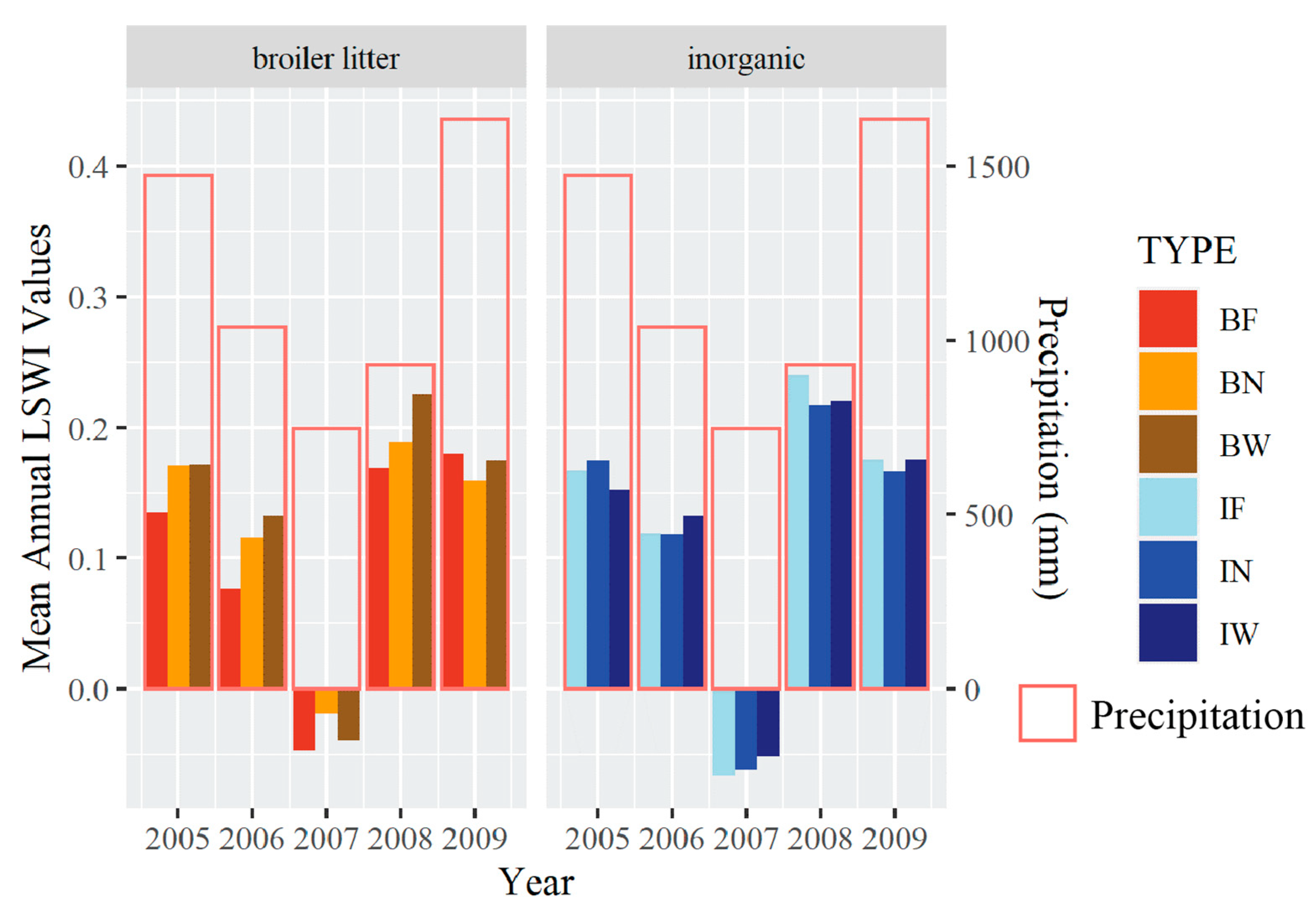
The values for each image were sorted by paddock type and averaged to create the mean annual values for each of the indices (Table 3). The mean annual NDVI values range from 0.3879 to 0.6938. The mean annual EVI values range from 0.2645 to 0.5280. The mean annual LSWI values range from −0.0662 to 0.2251. All paddock types had low vegetation index values throughout most of 2007, with BN and BW performing slightly better than the rest.

3.3. Sensitivities Analysis of NDVI, EVI, and LSWI Indices

Among the sensitivity analyses, we first analyzed the linear relationships between the unique pairings of the three indices (e.g., NDVI vs. EVI, EVI vs. LSWI, and NDVI vs. LSWI) across climate conditions (dry, wet, and normal; Figure 4). NDVI and EVI had strong linear relationships in all climate conditions (normal, wet, or dry). LSWI had linear relationships with NDVI and EVI in normal and wet years. However, the linear relationship between LSWI and NDVI/EVI was not strong in dry years. There are also many dispersed points in the LSWI versus NDVI/EVI relationships.
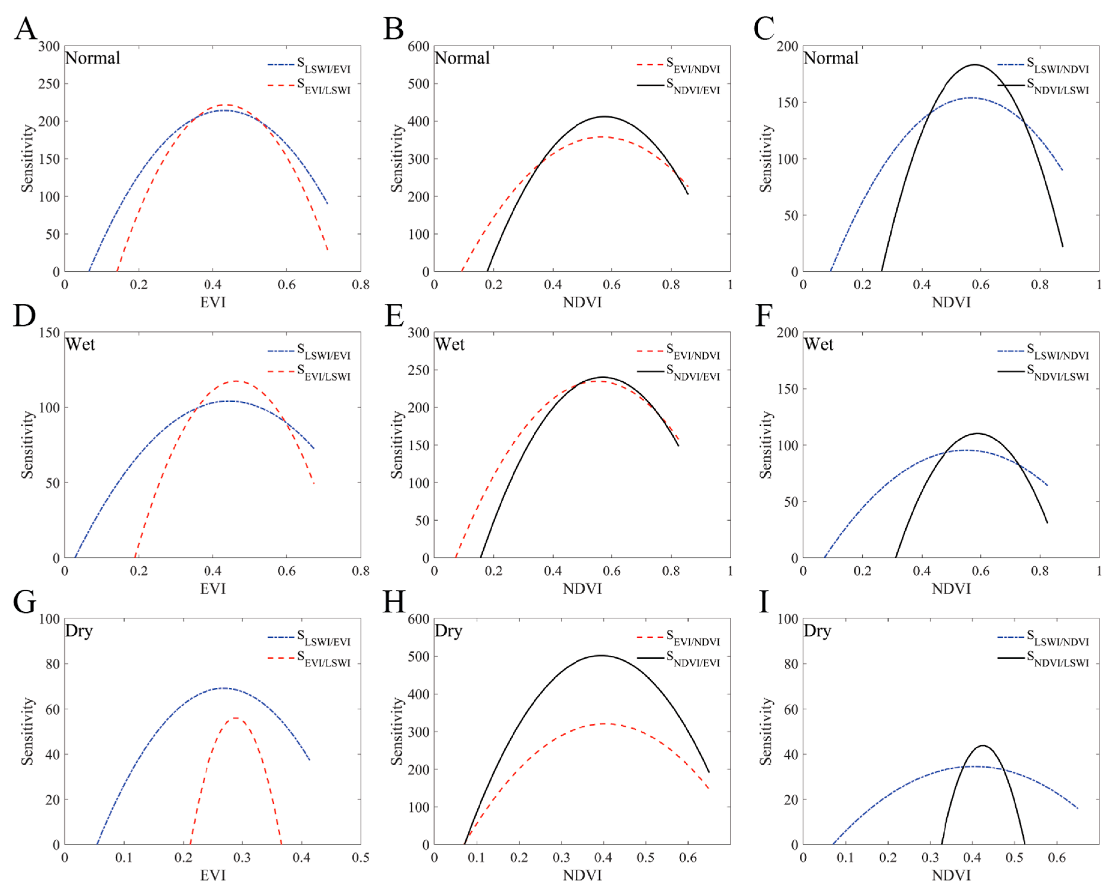
We first analyzed sensitivities between NDVI/EVI because they are highly correlated, and then compared the more sensitive option of the two to LSWI. It is important to note that we scaled LSWI to positive values by adding the greatest negative value to all LSWI values. This was done because the sensitivity calculations do not accept negative values. According to the sensitivity analysis (Figure 5), EVI was more sensitive than NDVI in wet years, but LSWI was more sensitive across a wider range of values. There was little deviation between each of the indices in normal years, but LSWI showed sensitivity across a wider range than both NDVI and EVI. NDVI showed much greater sensitivity than EVI in dry years, but LSWI showed sensitivity across a value range nearly triple that of NDVI. In agriculture, we are generally more interested in the extreme values (i.e., to identify healthy and non-healthy portions of the paddock) than central values. NDVI showed higher peak sensitivity values overall, but its sensitivity carried across a shorter range in nearly every scenario.

3.4. Time Series of LSWI Values Across Paddocks

The values of the LSWI index consistently followed the pattern of the precipitation data, with minor variations appearing due to missing dates of imagery. Dry months were followed by lower index values, while wet months, during every season except winter, were followed by higher index values. The time series charts (Figure 6; see Supplemental Table S1 for in-depth summary statistics) show discrepancies between paddocks of the same type. There are sharp declines showing in different months within paddock types in the 2006 charts. Reflecting the number of images shown previously in Table 2, the 2009 time series charts highlight the uneven temporal distribution of imagery in some of the years. Particularly, 2009 shows a large gap during the peak growth months of the year. Negative LSWI values indicate when a paddock is in a drought state, but 2008 shows some paddocks not going into a drought state along with the others because the paddocks not showing a drought state are missing images for the dates that the other paddocks are showing drought.

3.5. Boxplot Comparison of Fertilizer Type with Endophyte Association

Separated by paddock type, the boxplots (Figure 7) show which paddock types had higher mean LSWI values during the dry, normal, and wet years. During years with normal precipitation, the inorganic fertilizer combined with the wild-type endophyte had a slightly higher median LSWI value than the others, but the maximum values for all of the broiler litter paddock types were higher than all of the inorganic paddock types. During the dry year, the endophyte-free type fertilized with broiler litter performed the worst. However, all paddock types performed nearly the same during the wet year.

3.6. Statistical Significance of Fertilizer Type and Endophyte Association on LSWI

The interaction ANOVA test showed statistical significance (p = 0.05) by fertilizer type within the grazing period during only the dry year. Every other test resulted in relatively high p-values (Table 4 and Table 5).
The median LSWI values within the grazing period during the normal years were similar across all fertilizer/endophyte association types, with broiler litter/free resulting in the lowest and broiler litter/wild resulting in the highest. The wet year resulted in nearly identical results. However, the dry year showed broiler litter/free performing the worst and inorganic/wild performing slightly above all other types.

4. Discussion

4.1. Satellite Options

Landsat 7 ETM+ imagery was used for this study because the timeframe did not allow for the use of satellites with higher temporal and spatial resolutions, which presented some potential issues with data availability. While Landsat 7 ETM+ has a temporal resolution of 16 days, the SLC failure and cloud cover removal caused many of the images to have missing data within some of the paddocks. This resulted in an uneven number of images between years and paddocks within the same scan. Particularly, some paddocks had only one or two images during the grazing period of one of the years (2009). For more recent years, we now have the option of Sentinel-2 Multispectral Instrument (MSI) imagery with spatial resolutions of up to 10 m and a temporal resolution of five days. Without the SLC failure issue with Landsat 7 ETM+, Sentinel-2 MSI has potential to still provide a better, more complete dataset to work with.

4.2. Vegetation Index Sensitivities

While we found that LSWI had the greatest sensitivity, there are some overlapping results that show NDVI or EVI would be better for particular vegetation index value ranges. For years with normal precipitation, NDVI was more sensitive than LSWI between the value range of ~0.4 and ~0.8. Similarly, EVI was more sensitive than LSWI between the value range of ~0.37 and ~0.6 during wet years. Nevertheless, LSWI was more sensitive across a greater range of values, especially those of the extreme values that farm managers are generally more interested in identifying within their paddocks.

4.3. Tall Fescue Grassland Performance

Tall fescue supports many cattle operations in Georgia and it is important to understand what combination of endophyte association paired with fertilizer type performs best across varying climatic conditions. A recent study concerned with environmental conservation (e.g., hydrology) found that tall fescue fertilized with inorganic fertilizer has 30% greater runoff than with poultry litter [24]. From the same study, Franzluebbers et al. [23] found results suggesting that broiler litter was as effective as inorganic fertilizer for pasture growth and cattle production. They also found that cattle body weight gain from novel endophyte tall fescue paddocks were as good as those from endophyte free tall fescue paddocks.
In this study, the mean annual LSWI values showed a clear decline with precipitation, but the two years following the dry year did not follow the same pattern (Figure 8). The year directly following the dry year showed the highest mean annual LSWI values in all types except for the combination of broiler litter and endophyte free (BF) tall fescue paddocks. However, the BF paddocks were the only paddocks that showed an increase during the following year with nearly twice as much precipitation. It is also important to note that broiler litter and novel endophyte (BN) paddocks showed the highest LSWI values during the dry year. The combination of these two paddocks’ performance, combined with the lesser runoff of broiler litter when compared to inorganic fertilizers (Endale et al. 2013), suggests that the use of broiler litter on tall fescue paddocks could benefit both farm managers and the environment.

4.4. Manuresheds

There are plentiful poultry-based manureshed sources in Georgia, which can make broiler litter more readily available at comparable or cheaper prices than inorganic fertilizer (see [23]) in the same area (Figure 9). The results here show that there is a significant difference in LSWI values among paddock types in certain climatic conditions (especially dry years). The results of this research combined with the other studies mentioned here support increased use of LSWI as a proxy for tall fescue plant health, as well as consideration for increased adoption of broiler litter for fertilization purposes around the Georgia Piedmont.

4.5. Climate Trends

Climate data show an increase in the variability of dry and wet periods worldwide [32]. Following climate prediction models, farm managers should choose the fertilizer type and endophyte association that performs best in their predicted climate conditions [23]. The findings here provide a remote sensing based method incorporating the use of LSWI to determine fescue plant health. Moreover, employing these methods suggests that the plant health of those fields using broiler litter versus those that incorporated inorganic fertilizers did not have significant differences. Thus, looking forward, grazingland research/managers can continue to explore the use of the more sustainable process of using manure-based nutrients.

5. Conclusions

With all available options for vegetation indices to choose from, it can be difficult to decide which to use for a given application. Each research question has its own data needs and availability. A sensitivity analysis can identify the best option when comparing two indices, which in this case was LSWI. However, it is worth mentioning that for years with normal precipitation, NDVI was more sensitive than LSWI between the value range of ~0.4 and ~0.8. Similarly, EVI was more sensitive than LSWI between the value range of ~0.37 and ~0.6 during wet years. Nevertheless, LSWI was more sensitive across a greater range of values, especially for those of the extreme values that farm managers are generally more interested in identifying within their paddocks; thus, LSWI was utilized in the remainder of the research. The only significant difference in LSWI values between fertilizer type and endophyte combinations occurred during the year with low precipitation. The uneven temporal distribution of imagery available for the study area could have impacted some comparisons across years, so it may be worthwhile to repeat this study and focus on recent years with better available satellite data. Regardless of this limitation, the findings of this study support previous recommendations for using broiler litter to fertilize tall fescue in locations like the Georgia Piedmont. The data and findings also point to the potential use of satellite imagery in assessing grazingland tall fescue health and advancing the concept of poultry manureshed in the region or elsewhere where poultry manure production is extensive.

Supplementary Materials

The following are available online at https://www.mdpi.com/2072-4292/13/3/521/s1, Table S1: LSWI Summary Statistics.

Author Contributions

Conceptualization, K.C.F., T.L., D.E., and Y.Z.; methodology, K.C.F., T.L., D.E., and S.M.; software, K.C.F., T.L., and S.M.; validation, K.C.F., T.L., D.E., A.F., S.M., and Y.Z.; formal analysis, K.C.F., T.L., D.E., A.F., and S.M.; investigation, K.C.F., T.L., D.E., A.F., S.M., Y.Z.; resources, K.C.F., T.L., D.E., A.F., S.M., and Y.Z.; data curation, K.C.F., T.L., D.E., A.F., and S.M.; writing—original draft preparation, K.C.F. and T.L.; writing—review and editing, K.C.F., T.L., D.E., A.F., S.M., and Y.Z.; visualization, K.C.F., T.L., and S.M.; supervision, K.C.F., D.E., A.F., Y.Z.; project administration, K.C.F., T.L., D.E., A.F., S.M., and Y.Z.; funding acquisition, Y.Z. All authors have read and agreed to the published version of the manuscript.

Funding

This research was funded by National Science Foundation, grant number OIA-1946093 and the U.S. Geological Survey under Grant/Cooperative Agreement No. G18AP00077.

Institutional Review Board Statement

Not applicable.

Informed Consent Statement

Not applicable.

Acknowledgments

This research was a contribution from the Long-Term Agroecosystem Research (LTAR) network. LTAR is supported by the United States Department of Agriculture, which is an equal opportunity provider and employer. Y.Z would like to acknowledge the support by the National Science Foundation under Grant No. OIA-1946093 and the U.S. Geological Survey under Grant/Cooperative Agreement No. G18AP00077.

Conflicts of Interest

The authors declare no conflict of interest.

References

  1. Spiegal, S.; Kleinman, P.J.; Endale, D.M.; Bryant, R.B.; Dell, C.; Goslee, S.; Meinen, R.J.; Flynn, K.C.; Baker, J.M.; Browning, D.M.; et al. Manuresheds: Advancing Nutrient Recycling in US Agriculture. Agric. Syst. 2020, 182, 102813. [Google Scholar] [CrossRef]
  2. Davidson, E.A. The Contribution of Manure and Fertilizer Nitrogen to Atmospheric Nitrous Oxide since 1860. Nat. Geosci. 2009, 2, 659–662. [Google Scholar] [CrossRef]
  3. Raudsepp-Hearne, C.; Peterson, G.D.; Bennett, E.M. Ecosystem Service Bundles for Analyzing Tradeoffs in Diverse Landscapes. Proc. Natl. Acad. Sci. USA 2010, 107, 5242–5247. [Google Scholar] [CrossRef] [PubMed] [Green Version]
  4. Chadwick, D.; Sommer, S.; Thorman, R.; Fanguerio, D.; Cardenas, L.; Amon, B.; Misslebrook, T. Manure Management: Implications for Greenhouse Gas Emissions. Anim. Feed Sci. Technol. 2011, 166, 514–531. [Google Scholar] [CrossRef]
  5. Russelle, M.P.; Entz, M.H.; Franzluebbers, A.J. Reconsidering Integrated Crop-Livestock Systems in North America. Agron. J. 2007, 99, 325–334. [Google Scholar] [CrossRef] [Green Version]
  6. Kleinman, P.J.A.; Sharpley, A.N.; McDowell, R.W.; Flaten, D.N.; Buda, A.R.; Tao, L.; Bergstrom, L.; Zhu, Q. Managing Agricultural Phosphorus for Water Quality Protection: Principles for Progress. Plant Soil 2011, 349, 169–182. [Google Scholar] [CrossRef]
  7. Larney, F.J.; Hao, X.; Topp, E. Manure Management. In Soil Management: Building a Stable Base for Agriculture; Hatfield, J.L., Sauer, T.J., Eds.; Soil Science Society of America: Madison, WI, USA, 2015; pp. 245–263. [Google Scholar]
  8. Powers, S.M.; Chowdhury, R.B.; Macdonald, G.K.; Metson, G.S.; Beusen, A.H.W.; Bouwman, A.F.; Hampton, S.E.; Mayer, B.K.; McCrackin, M.L.; Vaccari, D.A. Global Opportunities to Increase Agricultural Independence through Phosphorus Recycling. Earth Future 2019, 7, 370–383. [Google Scholar] [CrossRef] [Green Version]
  9. Paudel, K.P.; Bhattarai, K.; Gauthier, W.M.; Hall, L.M. Geographic Information Systems (GIS) Based Model of Dairy Manure Transportation and Application with Environmental Quality Consideration. Waste Manag. 2009, 29, 1634–1643. [Google Scholar] [CrossRef]
  10. Stavast, L.J.; Baker, T.T.; Ulery, A.L.; Flynn, R.P.; Wood, M.K.; Cram, D.S. New Mexico Blue Grama Rangeland Response to Dairy Manure Application. Rangel. Ecol. Manag. 2005, 58, 423–429. [Google Scholar] [CrossRef]
  11. Nasim, W. Effect of Organic and Inorganic Fertilizer on Maize Hybrids under Agro-Environmental Conditions of Faisalabad-Pakistan. Afr. J. Agric. Res. 2012, 7, 2713–2719. [Google Scholar] [CrossRef]
  12. Knoll, J.E.; Anderson, W.F.; Malik, R.; Hubbard, R.K.; Strickland, T.C. Production of Napiergrass as a Bioenergy Feedstock under Organic Versus Inorganic Fertilization in the Southeast USA. BioEnergy Res. 2013, 6, 974–983. [Google Scholar] [CrossRef] [Green Version]
  13. Cabrera, V.E.; Stavast, L.; Baker, T.; Wood, M.; Cram, D.; Flynn, R.; Ulery, A. Soil and Runoff Response to Dairy Manure Application on New Mexico Rangeland. Agric. Ecosyst. Environ. 2009, 131, 255–262. [Google Scholar] [CrossRef]
  14. Caturegli, L.; Grossi, N.; Saltari, M.; Gaetani, M.; Magni, S.; Nikolopoulou, A.E.; Bonari, E.; Volterrani, M. Spectral Reflectance of Tall Fescue (Festuca Arundinacea Schreb) Under Different Irrigation and Nitrogen Conditions. Agric. Agric. Sci. Procedia 2015, 4, 59–67. [Google Scholar] [CrossRef]
  15. Trenholm, L.E.; Carrow, R.N.; Duncan, R.R. Relationship of multispectral radiometry data to qualitative data in turfgrass research. Crop Sci. 1999, 39, 763–769. [Google Scholar] [CrossRef]
  16. Jiang, Y.; Carrow, R.N. Broadband Spectral Reflectance Models of Turfgrass Species and Cultivars to Drought Stress. Crop Sci. 2007, 47, 1611–1618. [Google Scholar] [CrossRef]
  17. Hashemi, S.A.; Chenani, S.K. Investigation of NDVI Index in Relation to Chlorophyll Content Change and Phenological Event. In Recent Advances in Environment, Energy Systems and Naval Science, Proceedings of the 4th International Conference on Environmental and Geological Science and Engineering, Barcelona, Spain, 15–17 September 2011; WSEAS: Kos Island, Greece, 2011; pp. 22–28. [Google Scholar]
  18. Myneni, R.B.; Hall, F.G.; Sellers, P.J.; Marshak, A.L. The Interpretation of Spectral Vegetation Indexes. IEEE Trans. Geosci. Remote Sens. 1995, 33, 6. [Google Scholar] [CrossRef]
  19. Xue, J.; Su, B. Significant Remote Sensing Vegetation Indices: A Review of Developments and Applications. J. Sens. 2017, 2017, 1–17. [Google Scholar] [CrossRef] [Green Version]
  20. Chandrasekar, K.; Sesha Sai, M.V.R.; Roy, P.S.; Dwevedi, R.S. Land Surface Water Index (LSWI) Response to Rainfall and NDVI Using the MODIS Vegetation Index Product. Int. J. Remote Sens. 2010, 31, 3987–4005. [Google Scholar] [CrossRef]
  21. Prasetyo, Y.; Sukmono, A.; Aziz, K.W.; Aji, B.J.P.S. Rice productivity prediction model design based on linear regression of spectral value using NDVI and LSWI combination on Landsat-8 imagery. IOP Conf. Ser. Earth Environ. Sci. 2018, 165, 012002. [Google Scholar] [CrossRef] [Green Version]
  22. Yildirim, T.; Zhou, Y.; Flynn, K.C.; Gowda, P.H.; Ma, S.; Moriasi, D.N. Evaluating the sensitivity of vegetation and water indices to monitor drought For Three Mediterranean Crops. Agron. J. 2020, 2021, 1–12. [Google Scholar] [CrossRef]
  23. Franzluebbers, A.J.; Seman, D.H.; Stuedemann, J.A. Tall Fescue Persists and Cattle Perform Well on a Novel-Endophyte Association in the Southern Piedmont USA. Forage Grazinglands 2009, 7, 1–8. [Google Scholar] [CrossRef]
  24. Endale, D.M.; Franzluebbers, A.J.; Stuedemann, J.A.; Seman, D.S.; Franklin, D.H.; Schomberg, H.H. Runoff under Natural Rainfall from Small Tall Fescue Catchments in the Georgia Piedmont, United States. J. Soil Water Conserv. 2013, 68, 474–486. [Google Scholar] [CrossRef]
  25. Endale, D.; Schomberg, H.; Franzluebbers, A.; Seman, D.; Franklin, D.; Stuedemann, J. Runoff nutrient losses from tall fescue pastures varying in endophyte association, fertilization, and harvest management. J. Soil Water Conserv. 2021, 76, 25–38. [Google Scholar] [CrossRef]
  26. USDA NASS (National Agriculture Statistics Service). 2017 Census of Agriculture; USDA National Agriculture Statistics Service: Washington, DC, USA, 2020.
  27. NRCS SCAN. Soil Climate Analysis Network (SCAN) Data & Products; United States Department of Agriculture—Natural Resources Conservation Service: Washington, DC, USA, 2020.
  28. Storey, J.; Scaramuzza, P.; Schmidt, G.; Barsi, J. Landsat 7 scan line corrector-off gap filled product development. In Proceedings of the PECORA 16 Conference Proceedings, Sioux Falls, SD, USA, 23–27 October 2005; pp. 23–27. [Google Scholar]
  29. Ji, L.; Peters, A.J. Performance Evaluation of Spectral Vegetation Indices Using a Statistical Sensitivity Function. Remote Sens. Environ. 2007, 106, 59–65. [Google Scholar] [CrossRef] [Green Version]
  30. Schabenberger, O.; Pierce, F. Contemporary Statistical Models for the Plant and Soil Sciences. Available online: https://books.google.com.hk/books?hl=en&lr=&id=OyLNBQAAQBAJ&oi=fnd&pg=PP1&dq=Contemporary+Statistical+Models+for+the+Plant+and+Soil+Sciences&ots=sOd_Fqbj8X&sig=on8IcuWF1r85QkCApNnpWXGJq9g&redir_esc=y#v=onepage&q=Contemporary%20Statistical%20Models%20for%20the%20Plant%20and%20Soil%20Sciences&f=false (accessed on 30 December 2020). [CrossRef]
  31. Krzywinski, M.; Altman, N. Visualizing Samples with Box Plots. Nat. Methods 2014, 11, 119–120. [Google Scholar] [CrossRef]
  32. Konapala, G.; Mishra, A.K.; Wada, Y.; Mann, M.E. Climate Change Will Affect Global Water Availability through Compounding Changes in Seasonal Precipitation and Evaporation. Nat. Commun. 2020, 11, 1–10. [Google Scholar] [CrossRef]
Figure 1. Study area within Watkinsville, Georgia comprised of 14 paddocks of tall fescue (Schedonorus arundinaceus). However, only 12 of the paddocks were incorporated here because two (“Paddock Not Used”) were subject to cutting for hay instead of cattle grazing. Each paddock was named based on if broiler litter (B) or inorganic (I) fertilizer was applied and if the tall fescue type was free of endophytes (F), novel–tall fescue MaxQ type with novel endophytes (N), or wild type endophytes (W), with two paddocks of each combination type within the study area (i.e., BF, IF, BN, IN, etc.).
Remotesensing 13 00521 g001
Figure 2. Annual precipitation for Watkinsville, Georgia from the National Resource Conservation Service (NRCS) Soil Climate Analysis Network (SCAN) dataset [27]. The dashed line represents the long-term average precipitation value (30-yr; 1980–2010).
Remotesensing 13 00521 g002
Figure 3. Box plot of stocking rates (animal number/day/ha) between paddock types. B: Broiler litter; I: Inorganic fertilizer; F: Endophyte-free; N: novel endophyte; W: Wild endophyte.
Remotesensing 13 00521 g003
Figure 4. Correlation charts between vegetation index values and unique climate conditions (normal, wet, and dry). NDVI: normalized difference vegetation index; EVI: enhanced vegetation index; and LSWI: land surface water index.
Remotesensing 13 00521 g004
Figure 5. Unique comparisons of sensitivities between vegetation indices amongst differing climatic conditions (normal, wet, and dry). NDVI: normalized difference vegetation index; EVI: enhanced vegetation index; and LSWI: land surface water index. (A) Sensitivities comparison between EVI and LSWI during a normal year; (B) sensitivities comparison between EVI and NDVI during a normal year; (C) sensitivities comparison between NDVI and LSWI during a normal year; (D) sensitivities comparison between EVI and LSWI during a wet year; (E) sensitivities comparison between EVI and NDVI during a wet year; (F) sensitivities comparison between NDVI and LSWI during a wet year; (G) sensitivities comparison between EVI and LSWI during a dry year; (H) sensitivities comparison between EVI and NDVI during a dry year; (I) sensitivities comparison between NDVI and LSWI during a dry year.
Remotesensing 13 00521 g005
Figure 6. Time series charts for 2005–2009 showing land surface water index (LSWI) values and precipitation data overlaid with the grazing periods, shown in gray. Negative values indicate a drought state. Summary statistics can be found in Supplemental Table S1. Each paddock was named based on if broiler litter (B) or inorganic (I) fertilizer was applied and if the tall fescue type was free of endophytes (F), novel–tall fescue MaxQ type with novel endophytes (N), or wild type endophytes (W), with two paddocks of each combination type within the study area (i.e., BF, IF, BN, IN, etc.).
Remotesensing 13 00521 g006aRemotesensing 13 00521 g006bRemotesensing 13 00521 g006c
Figure 7. Box plots of mean land surface water index (LSWI) values during (a) normal (3 year), (b) wet (1 year), and (c) dry (1 year) years for each endophyte association (EA; free, novel, and wild) and fertilizer type (broiler litter or inorganic). The large circles represent the mean value for the respective paddocks. It is worth noting that inorganic wild and broiler litter free were significantly different (p < 0.05) from other pairs of endophyte and fertilizer types.
Remotesensing 13 00521 g007
Figure 8. Bar chart of mean annual land surface water index (LSWI) values across all study years. There is no significant (p > 0.05) difference within single year values across treatments. B: Broiler litter; I: Inorganic fertilizer; F: Endophyte-free; N: Novel endophyte; W: Wild endophyte.
Remotesensing 13 00521 g008
Figure 9. Maps of Georgia showing the number of cattle and poultry by county along with locations of 30 m rangelands (Crop Data Layer; USDA NASS 2020) that have potential to be grazed by cattle and fertilized by broiler litter. Rangelands here are categorized based on the Crop Data Layers corresponding to Grass/Pasture, Shrubland, and Other Hay/Non-Alfalfa.
Remotesensing 13 00521 g009
Table 1. Stocking rates for each paddock during the grazing periods. B: Broiler litter; I: Inorganic fertilizer; F: Endophyte free; N: novel–tall fescue MaxQ type with novel endophyte; W: Wild endophyte.
Grazing Period# of
Days
Stocking Rate (Animal Number/Day/Ha)
BN1IW2IF3BW4BF5IN6IF7IW8BN9BW10IN11BF12
Area (ha) 1.010.950.951.020.930.960.971.090.980.990.950.93
4/7/05–10/21/051983.253.913.314.343.833.283.245.643.354.763.263.68
11/10/05–1/5/06572.974.213.162.943.234.174.124.153.063.033.713.23
3/23/06–6/22/06923.675.343.334.504.484.104.577.174.405.824.144.23
10/5/06–2/2/071214.124.573.774.253.853.924.124.374.084.623.773.85
4/3/07–6/14/07732.753.562.933.162.992.903.095.453.634.612.932.99
10/16/07–12/11/07572.973.713.162.943.793.133.093.243.063.033.163.23
3/23/08–8/14/081412.973.032.113.323.013.133.094.593.234.252.113.23
10/28/08–1/7/09722.942.732.343.722.392.713.484.223.874.242.732.79
4/2/097–7/7/09972.974.083.164.333.233.874.124.593.065.053.163.23
Table 2. Total number of images collected for every paddock during each year. B: Broiler litter; I: Inorganic fertilizer; F: Endophyte-free; N: Novel endophyte; W: Wild endophyte.
Year20052006200720082009
Total # of images941499463130
BF127118510
BF58149512
BN17148611
BN97107612
BW107117512
BW48149511
IF38149511
IF79116510
IN117118510
IN68138511
IW29149511
IW8912669
Table 3. Mean annual vegetation index values for normalized difference vegetation index (NDVI), enhanced vegetation index (EVI), and land surface water index (LSWI) between paddock types across all years (2005 to 2009) in the study. B: Broiler litter; I: Inorganic fertilizer; F: Endophyte-free; N: Novel endophyte; W: Wild endophyte.
Mean Annual NDVI Values
Paddock TypeBFBNBWIFINIW
20050.58520.63780.61700.57710.61540.5582
20060.52080.53940.55940.56410.55820.5670
20070.38790.44090.44080.42200.41140.4292
20080.63110.61640.68350.69380.68800.6846
20090.57530.58170.60320.61310.56620.6061
Mean Annual EVI Values
Paddock TypeBFBNBWIFINIW
20050.44980.48910.46790.44310.48500.4370
20060.38490.39380.41790.41820.41590.4215
20070.26450.30220.30200.28500.27540.2882
20080.46870.45820.51490.52800.27540.5175
20090.46450.44690.47450.48260.44500.4785
Mean Annual LSWI Values
Paddock TypeBFBNBWIFINIW
20050.13490.17080.17200.16730.17520.1521
20060.07720.11540.13210.11880.11840.1323
2007−0.0472−0.0186−0.0393−0.0661−0.0622−0.0515
20080.16900.18920.22510.17550.21730.2205
20090.17990.15940.17490.17550.16600.1758
Table 4. Two-way ANOVA results for fertilizer (broiler litter or inorganic) and endophyte associations (EA; free, novel, or wild).
Normal
Two-way LSWI~FERTILIZER + EA
DfSum sqMean sqF valuePr (>F)
FERTILIZER10.01610.016110.9770.324
EA20.00940.0046920.2850.753
Residuals1612.65380.016483
Wet
Two-way LSWI~FERTILIZER + EA
DfSum sqMean sqF valuePr (>F)
FERTILIZER10.0002562.56 × 10−41.1030.324
EA29.11 × 10−54.56 × 10−50.1960.826
Residuals80.0018582.32 × 10−4
Dry
Two-way LSWI~FERTILIZER + EA
DfSum sqMean sqF valuePr (>F)
FERTILIZER10.0009380.0009383.1810.112
EA20.0012690.0006352.1520.179
Residuals80.0023590.000295
Table 5. Interaction ANOVA results for fertilizer (broiler litter or inorganic) and endophyte associations (EA; free, novel, or wild).
Normal
Interaction LSWI~FERTILIZER * EA
DfSum sqMean sqF valuePr (>F)
FERTILIZER10.01610.016110.9730.326
EA20.00940.0046920.2830.754
FERTILIZER:EA20.02030.0101340.6120.544
Residuals1592.63350.016563
Wet
Interaction LSWI~FERTILIZER * EA
DfSum sqMean sqF valuePr (>F)
FERTILIZER10.0002562.56 × 10−41.0890.337
EA29.11 × 10−54.56 × 10−50.1930.829
FERTILIZER:EA20.0004462.23 × 10−40.9470.439
Residuals60.0014122.35 × 10−4
Dry
Interaction LSWI~FERTILIZER * EA
DfSum sqMean sqF valuePr (>F)
FERTILIZER10.0009380.0009385.7370.0536
EA20.0012690.0006353.8810.0829
FERTILIZER:EA20.0013780.0006894.2140.0719
Residuals60.0009810.000164
Publisher’s Note: MDPI stays neutral with regard to jurisdictional claims in published maps and institutional affiliations.