An Improved Segmentation Method for Automatic Mapping of Cone Karst from Remote Sensing Data Based on DeepLab V3+ Model
Abstract
1. Introduction
2. Study Area
3. Methodology
3.1. Training Datasets
3.2. Data Processing
3.2.1. Data Preprocessing
3.2.2. Generation of Training Samples
Basic Training Samples
Three-Channel Fusion Training Samples
Four-Channels RGB-D Training Samples
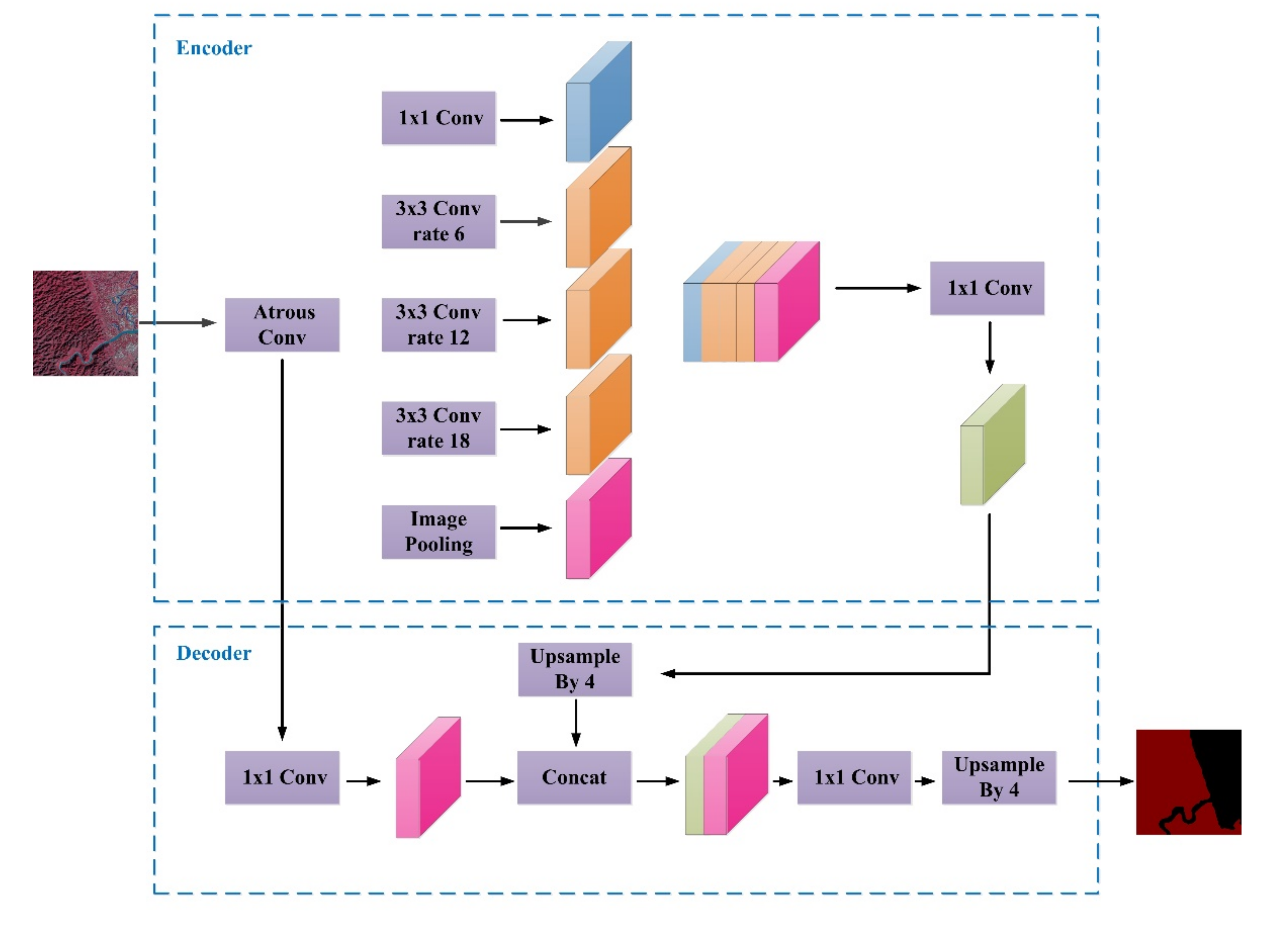
3.3. DeepLab V3+ Model
4. Segmentation Results of Cone Karst Landscape
4.1. Training Details of DeepLab V3+ Network
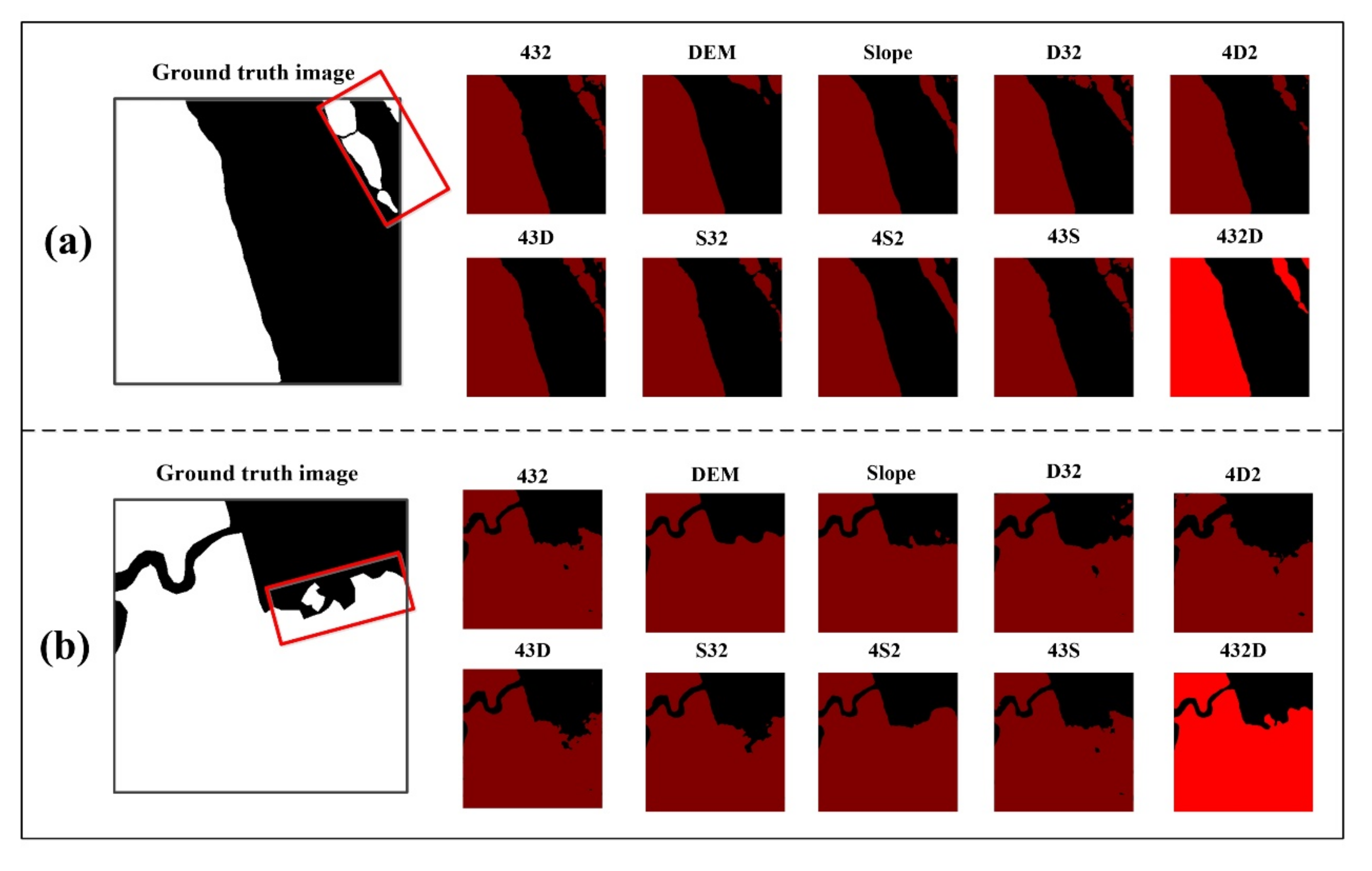
4.2. Segmentation Results
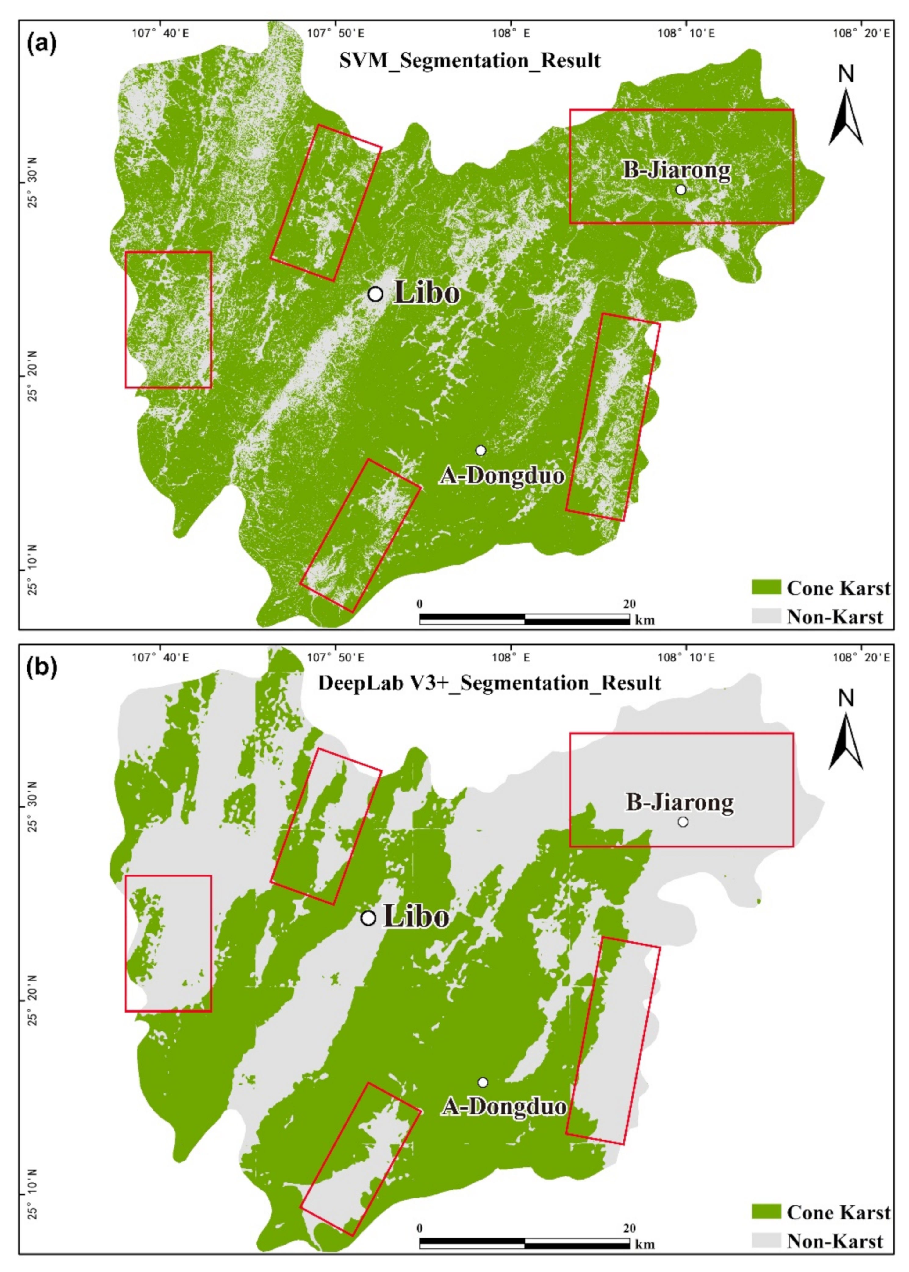
4.3. Comparison of the Segmentation Results by SVM and DeepLab V3+
5. Discussion
6. Conclusions
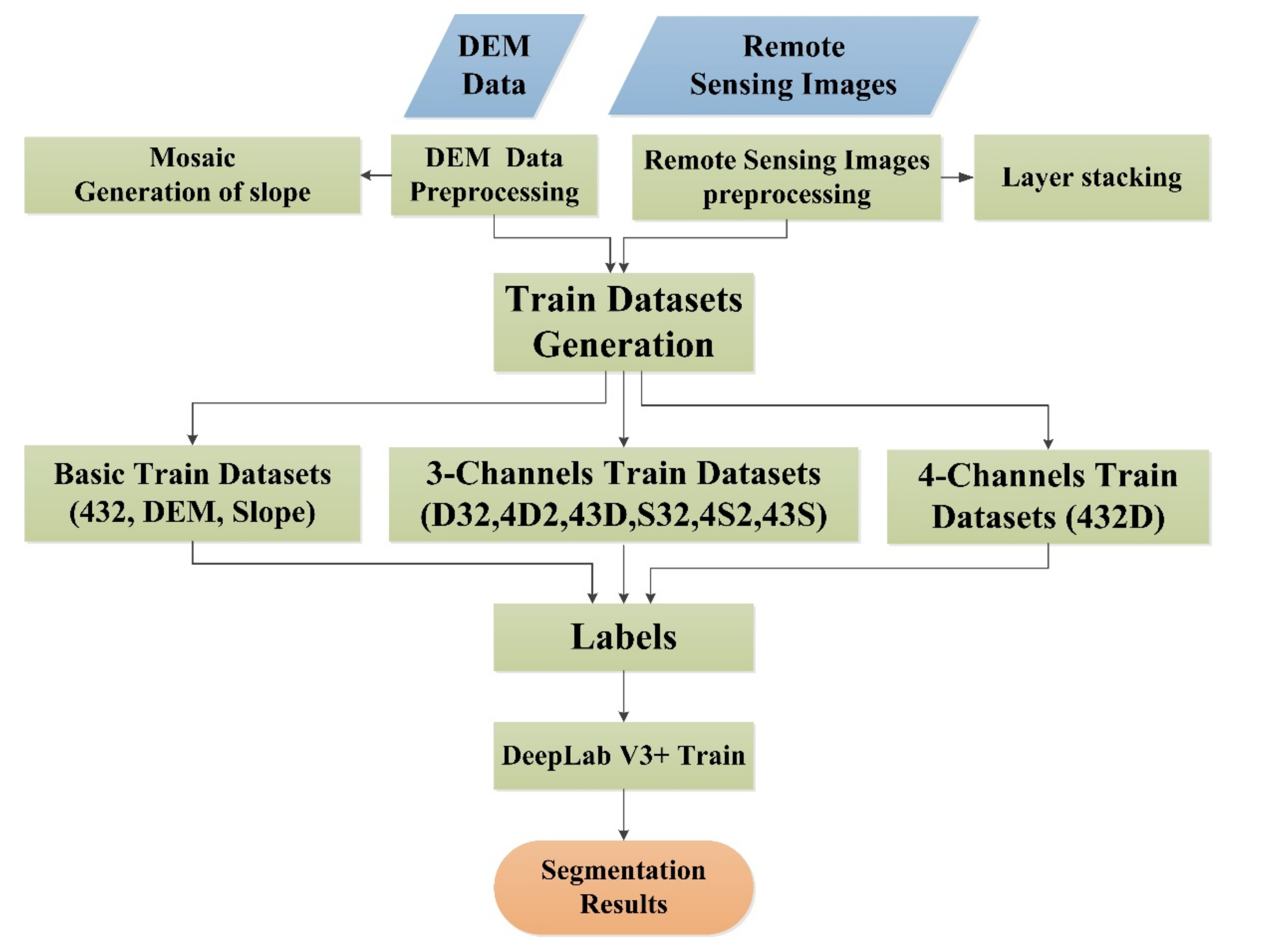
- An improved DeepLab V3+ network has been proposed to carry out semantic segmentation using multi-source remote sensing images. A set of machine learning samples of cone karst landscape and a set of four-channel data were further obtained from the fusion of optical remote sensing image and DEM data. The input module of DeepLab V3+ model was adjusted so that the network can accept multi-channels (four channels or more) data.
- It is found that the segmentation results using different combinations of four-channel data (i.e., 432D) has the highest accuracy of 95.53% in terms of MIoU. The second highest accuracy is that three-channel training data of 43D because the green band of Landsat data was replaced by the DEM data, which can largely reduce the atmospheric influence on Landsat image. Thus, the segmentation accuracy is higher than the results using other three-channel training samples.
- Compared with the SVM method, the major advantage of segmentation results from the DeepLab V3+ model is that the deep neural network structure can effectively distinguish the cone karst and carbonate hilly landscapes through multiple deep convolution layers and pooling layers as verified by the field observation and UAV investigations.
Author Contributions
Funding
Institutional Review Board Statement
Informed Consent Statement
Data Availability Statement
Acknowledgments
Conflicts of Interest
References
- Yuan, D.X.; Liu, Z.H.; Lin, Y.S.; Shen, J.F.; He, S.Y.; Xu, S.Y.; Yang, L.Z.; Li, B.; Dian, J.M.; Cai, W.T.; et al. China Karst Power System; Geological Publishing House: Beijing, China, 2002; pp. 3–13. [Google Scholar]
- Yi, Y.N.; Zhang, W.C. A new deep-learning-based approach for earthquake-triggered landslide detection from single-temporal rapideye satellite imagery. IEEE J. Sel. Top. Appl. Earth Obs. Remote Sens. 2020, 13, 6166–6176. [Google Scholar] [CrossRef]
- Luo, W.; Yan, Z.W.; Xue, C.S. DEM-based extraction and analysis of topographical features in karst areas. J. Cent. China Norm. Univ. 2013, 47, 436–439, (In Chinese with English abstract). [Google Scholar]
- Zhou, Z.F.; Huang, L.J.; Xiao, D. Remote sensing investigation of Karst rocky desertification in Guizhou plateau: A case study of Qingzhen City, Guizhou Province. Guizhou Geol. 2001, 18, 93–98, (In Chinese with English abstract). [Google Scholar]
- Zhou, Z.F. Application of remote sensing and GIS technology in the study of land rocky desertification in Guizhou Karst Area. Soil Water Conserv. Bull. 2001, 21, 52–54, (In Chinese with English abstract). [Google Scholar]
- Li, W.H.; Yu, D.Q. Study on remote sensing survey technology and method of rocky desertification in Karst Rocky Mountain area. Remote Sens. Land Resour. 2002, 1, 34–37, (In Chinese with English abstract). [Google Scholar]
- Tong, L.Q. Study on automatic extraction technology of rocky desertification information in Karst Rocky Mountain Area of Southwest China. Remote Sens. Land Resour. 2003, 4, 35–38, (In Chinese with English abstract). [Google Scholar]
- Li, S.; Wu, H. Mapping karst rocky desertification using Landsat 8 images. Remote Sens. Lett. 2015, 6, 657–666. [Google Scholar] [CrossRef]
- He, Z.H.; Liang, H.; Huang, F.S.; Zhao, F. Identification of geomorphic types in karst basin based on DEM. Geod. Geodyn. 2008, 28, 46–53, (In Chinese with English abstract). [Google Scholar]
- Li, F.; Yang, X.P.; Hao, H.K. Extraction of mountain and water system information in karst landform based on DEM: A case study of Yangshuo County, Guilin. Surv. Spat. Geogr. Inf. 2015, 8, 73–76, (In Chinese with English abstract). [Google Scholar]
- Xue, X.W.; Chen, X.; Zhang, Z.C.; Qin, N.X. Discrimination of geomorphic types of karst basin based on the characteristic value of topographic factors. Carsologica Sin. 2009, 28, 175–180, (In Chinese with English abstract). [Google Scholar]
- Liang, F.; Xu, B. Discrimination of tower-, cockpit-, and non-karst landforms in Guilin, Southern China, based on morphometric characteristics. Geomorphology 2014, 204, 42–48. [Google Scholar] [CrossRef]
- Theilenwillige, B.; Malek, H.; Charif, A.; El Bchari, F.; Chaïbi, M. Remote sensing and GIS contribution to the investigation of Karst landscapes in NW-Morocco. Geosciences 2014, 4, 50–72. [Google Scholar] [CrossRef]
- Litwin, L.; Andreychouk, V. Characteristics of high-mountain karst based on GIS and Remote Sensing. Environ. Geol. 2008, 54, 979–994. [Google Scholar] [CrossRef]
- Lecun, Y.; Bengio, Y.; Hinton, G. Deep learning. Nature 2015, 521, 436–444. [Google Scholar] [CrossRef]
- Goodfellow, I.; Bengio, Y.; Courville, A. Deep Learning; Massachusetts Institute of Technology Press: Cambridge, MA, USA, 2016; pp. 1–8. [Google Scholar]
- Lan, Z. Build-Up Land Extraction from Medium and High Resolution Remote Sensing Images. Master’s Thesis, University of Electronic Science and Technology of China, Chengdu, China, 21 May 2020. [Google Scholar]
- Liu, W.Y.; Yue, A.Z.; Ji, J.; Shi, W.H.; Deng, R.R.; Liang, Y.H.; Xiong, L.H. Urban green space extraction from GF-2 remote sensing image based on DeepLab V3+ semantic segmentation model. Remote Sens. Land Resour. 2020, 32, 120–129, (In Chinese with English abstract). [Google Scholar]
- Wang, Z.H.; Zhong, Y.F.; He, W.W.; Qu, N.Y.; Xu, L.Z.; Zhang, W.P.; Liu, Z.X. Island shoreline segmentation in remote sensing image based on improved DeepLab network. J. Image Graph. 2020, 25, 0768–0778. [Google Scholar]
- Long, J.; Shelhamer, E.; Darrell, T. Fully convolutional networks for semantic segmentation. IEEE Trans. Pattern Anal. Mach. Intell. 2014, 39, 640–651. [Google Scholar]
- Chen, L.C.; Papandreou, G.; Kokkinos, I.; Murphy, K.; Yuille, A.L. Semantic image segmentation with deep convolutional nets and fully connected CRFs. Comput. Sci. 2014, 4, 357–361. [Google Scholar]
- Chen, L.C.; Papandreou, G.; Kokkinos, I.; Murphy, K.; Yuille, A.L. DeepLab: Semantic image segmentation with deep convolutional nets, atrous convolution, and fully connected CRFs. IEEE Trans. Pattern Anal. Mach. Intell. 2016, 99, 834–848. [Google Scholar] [CrossRef]
- Chen, L.C.; Papandreou, G.; Schroff, F.; Adam, H. Rethinking atrous convolution for semantic image segmentation. Computer vision and pattern recognition. arXiv 2017, arXiv:1706.05587. [Google Scholar]
- Chen, L.C.; Zhu, Y.; Papandreou, G.; Schroff, F.; Adam, H. Encoder-decoder with atrous separable convolution for semantic image segmentation. Computer vision and pattern recognition. arXiv 2018, arXiv:1802.02611. [Google Scholar]
- Plath, N.; Toussaint, M.; Nakajima, S. Multi-class image segmentation using conditional random fields and global classification. In Proceedings of the 26th Annual International Conference on Machine Learning, ACM, Montreal, QC, Canada, 14–18 June 2009; pp. 817–824. [Google Scholar]
- Kokkinos, I. Pushing the boundaries of boundary detection using deep learning. arXiv 2016, arXiv:1511.07386. [Google Scholar]
- Zheng, S.; Jayasumana, S.; Romera-Paredes, B.; Vineet, V.; Su, Z.Z.; Du, D.L.; Huang, C.; Torr, H.S.P. Conditional random fields as recurrent neural networks. In Proceedings of the 2015 IEEE International Conference on Computer Vision (ICCV), Santiago, Chile, 11–18 December 2015; pp. 1529–1537. [Google Scholar] [CrossRef]
- Zhang, L.G. Image Semantic Segmentation Based on Full Cavity Convolutional Neural Network. Master’s Thesis, Northeast Normal University, Changchun, China, 1 May 2018. (In Chinese with English abstract). [Google Scholar]
- Papandreou, G.; Kokkinos, I.; Savalle, P.A. Modeling local and global deformations in deep learning: Epitomic convolution, multiple instance learning, and sliding window detection. In Proceedings of the 2015 IEEE Conference on Computer Vision and Pattern Recognition (CVPR), Boston, MA, USA, 7–12 June 2015; pp. 390–399. [Google Scholar] [CrossRef]
- Chen, L.C.; Yang, Y.; Wang, J.; Xu, W.; Yuille, A.L. Attention to scale: Scale-aware semantic image segmentation. In Proceedings of the 2016 IEEE Conference on Computer Vision and Pattern Recognition (CVPR), Las Vegas, NV, USA, 26 June–1 July 2016; pp. 3640–3649. [Google Scholar] [CrossRef]
- He, K.; Zhang, X.; Ren, S.; Sun, J. Spatial pyramid pooling in deep convolutional networks for visual recognition. IEEE Trans. Pattern Anal. Mach. Intell. 2015, 37, 1904–1916. [Google Scholar] [CrossRef] [PubMed]
- Everingham, M.; Gool, L.V.; Williams, C.K.I.; Winn, J.; Zisserman, A. The pascal, visual object classes (VOC) challenge. Int. J. Comput. Vis. 2010, 88, 303–338. [Google Scholar] [CrossRef]
- Waltham, T. Fengcong, fenglin, cone karst and tower karst. Cave Karst Ence 2008, 35, 77–88. [Google Scholar]
- Xiong, K.N.; Xiao, S.Z.; Chen, P.D. Global comparative analysis of the value of karst and cone-shaped karst heritage in southern China. In Proceedings of the Seminar on the Development of Leisure Agriculture across the Taiwan Straits, Taiwan, China, 8–14 September 2008. (In Chinese with English abstract). [Google Scholar]
- Tian, S.J. Study on the Formation and Evolution of Cone-Shaped Karst Landform in Libo World Natural Heritage site. Master’s Thesis, Guizhou Normal University, Guiyang, China, 1 June 2008. (In Chinese with English abstract). [Google Scholar]
- Dai, C.G.; Wang, M.; Chen, J.S.; Wang, X.H. Characteristics of Guizhou tectonic movement and its geological significance. Guizhou Geol. 2013, 30, 119–124, (In Chinese with English abstract). [Google Scholar]
- Huang, W. Spatial Dimensions of Tower Karst and Cockpit Karst: A Case Study of Guilin, China. Ph.D. Thesis, University of Wisconsin-Milwaukee, Milwaukee, WI, USA, December 2014. [Google Scholar]
- Cheng, Y.; Shen, L.N.; Mo, Y.F.; Sun, Y. Research status and prospect of remote sensing extraction method of karst rocky desertification information. J. Guilin Univ. Technol. 2015, 35, 193–198, (In Chinese with English abstract). [Google Scholar]
- Li, G.C. Global Geomorphic Comparison and World Heritage Values of South China Karst. Master’s Thesis, Guizhou Normal University, Guiyang, China, 5 June 2014. (In Chinese with English abstract). [Google Scholar]
- Vapnik, V.N.; Lerner, A.Y. Recognition of patterns with help of generalized portraits. Avtomat. I Telemekh 1963, 24, 774–780. [Google Scholar]
- Kavzoglu, T.; Colkesen, I. A kernel functions analysis for support vector machines for land cover classification. Int. J. Appl. Earth Obs. Geoinf. 2009, 11, 352–359. [Google Scholar] [CrossRef]
- Yu, Y.; Li, Q.H. Statistical learning theory and support vector machine. J. Shenyang Univ. 2005, 17, 42–47, (In Chinese with English abstract). [Google Scholar]
- Hu, Y.H. Research and application of support vector machine. J. Yuncheng Univ. 2012, 30, 4–7, (In Chinese with English abstract). [Google Scholar]


| Hardware | CPU | Intel i7 |
| RAM | 8GB | |
| Display Card | NVIDIA TITAN XP | |
| Display Memory | 12GB | |
| Hard Disk | 2TB | |
| Software | Code Language | Python 2.7 |
| Train Framework | Tensorflow | |
| Train Network | DeepLab V3+ | |
| Sample Label | Labelme | |
| Train Times | 40000 |
| Sets | MIoU |
|---|---|
| 432 | 92.10% |
| DEM | 88.78% |
| Slope | 59.15% |
| D32 | 91.92% |
| 4D2 | 91.72% |
| 43D | 93.96% |
| S32 | 91.62% |
| 4S2 | 92.86% |
| 43S | 92.39% |
| 432D | 95.53% |
Publisher’s Note: MDPI stays neutral with regard to jurisdictional claims in published maps and institutional affiliations. |
© 2021 by the authors. Licensee MDPI, Basel, Switzerland. This article is an open access article distributed under the terms and conditions of the Creative Commons Attribution (CC BY) license (http://creativecommons.org/licenses/by/4.0/).
Share and Cite
Fu, H.; Fu, B.; Shi, P. An Improved Segmentation Method for Automatic Mapping of Cone Karst from Remote Sensing Data Based on DeepLab V3+ Model. Remote Sens. 2021, 13, 441. https://doi.org/10.3390/rs13030441
Fu H, Fu B, Shi P. An Improved Segmentation Method for Automatic Mapping of Cone Karst from Remote Sensing Data Based on DeepLab V3+ Model. Remote Sensing. 2021; 13(3):441. https://doi.org/10.3390/rs13030441
Chicago/Turabian StyleFu, Han, Bihong Fu, and Pilong Shi. 2021. "An Improved Segmentation Method for Automatic Mapping of Cone Karst from Remote Sensing Data Based on DeepLab V3+ Model" Remote Sensing 13, no. 3: 441. https://doi.org/10.3390/rs13030441
APA StyleFu, H., Fu, B., & Shi, P. (2021). An Improved Segmentation Method for Automatic Mapping of Cone Karst from Remote Sensing Data Based on DeepLab V3+ Model. Remote Sensing, 13(3), 441. https://doi.org/10.3390/rs13030441


