Article

Characteristics of Deep Convective Systems and Initiation during Warm Seasons over China and Its Vicinity

1
Key Laboratory for Aerosol-Cloud-Precipitation of China Meteorological Administration, Nanjing University of Information Science and Technology, Nanjing 210044, China
2
Precision Regional Earth Modeling and Information Center, Nanjing University of Information Science and Technology, Nanjing 210044, China
3
National Meteorological Center, Beijing 100081, China
4
Chinese Academy of Meteorological Science, Beijing 100081, China
5
State Key Laboratory of Operation and Control of Renewable Energy & Storage Systems, Chinese Electric Power Research Institute, State Grid of Corporation of China, Beijing 100035, China
*
Author to whom correspondence should be addressed.
Remote Sens. 2021, 13(21), 4289; https://doi.org/10.3390/rs13214289
Submission received: 29 September 2021 / Revised: 21 October 2021 / Accepted: 22 October 2021 / Published: 25 October 2021

Abstract

:
The spatiotemporal statistical characteristics of warm-season deep convective systems, particularly deep convective systems initiation (DCSI), over China and its vicinity are investigated using Himawari-8 geostationary satellite measurements collected during April-September from 2016 to 2020. Based on a satellite brightness temperature multiple-threshold convection identification and tracking method, a total of 47593 deep convective systems with lifetimes of at least 3 h were identified in the region. There are three outstanding local maxima in the region, located in the southwestern, central and eastern Tibetan Plateau and Yunnan-Guizhou Plateau, followed by a region of high convective activities in South China. Most convective systems are developed over the Tibetan Plateau, predominantly eastward-moving, while those developed in Yunnan-Guizhou Plateau and South China mostly move westward and southwestward. The DSCI occurrences become extremely active after the onset of the summer monsoon and tend to reach a maximum in July and August, with a diurnal peak at 11–13 LST in response to the enhanced solar heating and monsoon flows. Several DCSI hotspots are identified in the regions of inland mountains, tropical islands and coastal mountains during daytime, but in basins, plains and coastal areas during nighttime. DCSI over land and oceans exhibits significantly different sub-seasonal and diurnal variations. Oceanic DCSI has an ambiguous diurnal variation, although its sub-seasonal variation is similar to that over land. It is demonstrated that the high spatiotemporal resolution satellite dataset provides rich information for understanding the convective systems over China and vicinity, particularly the complex terrain and oceans where radar observations are sparse or none, which will help to improve the convective systems and initiation nowcasting.

1. Introduction

Deep convective systems occur frequently in China and its vicinity during the warm season, producing a wide range of severe weather phenomena, including heavy rainfall, lightning, hail, damaging winds and even tornadoes [1,2,3,4,5,6]. Deep convective precipitation affects hydrological processes and regional and global climate through redistribution of water and energy. Therefore, improving the understanding of deep convective systems occurrences and initiation, over China, especially in the regions with complex terrain (such as the Tibetan Plateau (TP) and near-shore oceans), is critical to advancing our knowledge of hydrologic and climate systems and producing accurate predictions of convective damages.
A great deal of attention has been put on understanding the characteristics of convective systems [7,8,9,10,11]. Several researchers have studied the spatial distribution, seasonal and diurnal variation of convective systems, and precipitation over China and its vicinity using satellite measurements (e.g., Feng-Yun 2, Himawari-8, etc.), weather radar, or combined observations [11,12,13,14,15,16,17,18,19,20,21]. However, there is a lack of understanding of the integral spatiotemporal distribution of the convection storms in this region, including their initiations, lifecycles (initiation, mature, and dissipation stages), propagation (speed and direction) and vertical velocity of the deep convection.
Deep convective systems initiation (DCSI), a precursor of a convective storm [22], has been studied using geostationary satellite, weather radar, lightning, or combined observations for several regions [23,24,25,26,27]. DCSI is defined by occurrence of the first weather radar precipitation echo reaching a given threshold [28]. DCSI is generally affected by large-scale synoptic forcing, regional and local circulations, and terrain intersections [29]. Several field campaigns were carried out worldwide to understand DCSI and evolutionary processes over complex terrain areas to (a) improve prediction of the location and timing of new convection and (b) improve quantitative precipitation forecasting (QPF) skills [23,30,31,32,33,34]. Much work has been done to study the physical mechanisms of DCSI based on numerical weather models, and/or multi-platform measurements over the North China, South China and Eastern China, respectively [35,36,37,38]. Several statistical studies of DCSI have also been done in these regions in recent years using satellite and/or Doppler weather radar measurements [19,26,27,39,40,41]. However, there is no work done to explore the systematic features of DCSI over the nation-wide region across China and its vicinity, nor comparison of DCSI in the subregions with different climates.
Data available for these earlier studies are in much lower resolution than today. Liang and Fritcsh [20] identified and examined the statistical characteristics of mesoscale convective complexes around the world (including China) using the ISCCP (International Satellite Cloud Climatology Project) observations with 30 km grid resolution and 3-h intervals. Hu et al. [42,43] analyzed seasonal and diurnal variation of Tibetan Convective Systems with data at 3-h intervals, which were too coarse to represent the characteristics of DCSI. Mai et al. [15] analyzed mesoscale convective systems over the Tibetan Plateau (TP) using multiple satellite measurements during warm seasons from 2000 to 2016, but did not discuss DCSI. Zhang et al. [40] analyzed the satellite brightness measurements characteristics of mesoscale convective complex from initiation to maturity over Sichuan Basin (SB) using FY-4A measurements in 2018, but not the characteristics of DCSI. Similarly, Meng et al. [11] studied the climatological characteristic of mesoscale convective systems in the southwest mountains area of China, but did not include initiation.
The vertical velocity is one of the most important convection parameters [44,45]. Many efforts have been put on estimating cloud vertical velocity, with in-situ measurements of aircrafts penetrating cumulus clouds [46], remote sensing of wind profilers and ground-based weather radars or weather satellites [44,45,47,48]. It is of great interest to study the vertical velocity of the convective clouds in China and its vicinity.
The objective of this study is to reveal the spatial distributions and the sub-seasonal and diurnal variation of deep convective systems over a great area covering China and its vicinity. The characteristic of deep convective systems initiation over China is analyzed. An innovative cloud identification and tracking method is applied to the Himawari-8 geostationary satellite measurements. Unlike weather radars, geostationary satellites provide measurements with uniform quality and density over broader regions, including the western China where complex terrain dominates and few weather radars exist. This paper is organized in the following way. In Section 2, the satellite data, a method for identifying and tracking convective systems and a method for estimating vertical velocity are described. Section 3 analyzes DCSI, lifetime, and propagation of the deep convection storms across China and its vicinity and compare cloud top height and vertical velocity of the convection systems over land and ocean. Finally, Section 4 summarize the findings and conclusions of this work.

2. Data and Methods

2.1. Himawari-8 and Reanalysis Data

The satellite data used in this study are infrared brightness temperature acquired by AHI (Advanced High-resolution Imager) onboard Himawari-8 that was launched by the Japan Meteorological Agency (JMA) in October 2014. AHI has 3 visible channels, 3 near-infrared channels, and 10 infrared channels. In this study, we used measurements in the infrared window channel (central wavelength: 10.4 μm, Channel 13) with a temporal resolution of 10 min and a spatial resolution of 5 km. The Himawari-8 brightness temperature measurements during warm seasons (April–September) from 2016 to 2020 were used to identify and track convective systems over China and its vicinity (80°E-135°E, 10°N-55°N, Figure 1a). The eight distinct regions (Hetao (HT), North China (NC), Central Eastern China (CE), Sichuan Basin (SB), Tibetan Plateau (TP), Yunnan-Guizhou Plateau (YP), South China (SC) and Ocean (OC)) listed in Table 1 and marked Figure 1a were further investigated based on elevation and geographical characteristics of each region (mountains, foothills, basin and ocean).
In addition to Channel 13, the Himawari-8 Level-2 (L2) product of Cloud Top Height (CTH) and atmospheric environmental variables from ERA5 (European Centre for Medium-Range Weather Forecasts (ECMWF) Reanalysis v5) atmospheric reanalysis data were used to estimate convective top vertical velocity. ERA5 reanalysis data from ECMWF extend from 1950 to the present [49], with horizontal resolutions of 0.125° × 0.125° and 27 pressure levels from 1000 to 100 hPa.

2.2. Convection Identification and Tracking Algorithm

One of the most commonly used methods to identify convective systems is to detect a contiguous area of cloud top temperature minima in infrared window channel imageries. Some single-threshold methods have been developed. With these methods, cloud top brightness temperatures were used to identify and track convective systems by defining a brightness temperature threshold, e.g., 241 K by Maddox [50]. However, the single threshold methods require an artificial choice of the brightness temperature threshold, which is generally difficult to define, but critical: a weak restrictive threshold can lead to spurious results, but a strong restrictive threshold may miss the convective systems during their initial and decaying stage [51].
In order to solve this problem, in this work, we use a Python library called “tobac” (Tracking and Object-Based Analysis of Clouds) [51] to apply a range of threshold values in identifying and tracking convective systems. First, a Gaussian filter is used to smooth the 5-km brightness temperature and a weighted mean is applied to extract the geometric center of cloud features that are identified by multiple thresholds, from 270 to 170 K at steps of 5 K. Next, the water-shedding segmentation technologies by Soille et al. [52] was used to associate areas with each identified feature. Finally, a linking method based on “trackpy” developed by Allan et al. [53] was used to link the individual features and associated area masks identified in each time step into cloud trajectories. Nevertheless, it does not include an implicit treatment of the splitting and merging of clouds. The “tobac” is able to count in the clouds at initiation and decaying stages, besides the mature ones, and helps to analyze the cloud lifecycle by extrapolating trajectories to additional output time step. More details about “tobac” can be found in Heikenfeld et al. [51].
The AHI reflectance at 10.4 μm (Channel 13) was used in this study as an indicator of the cloud top temperature for deep convective systems. In the present study, an additional criterion was further imposed to define a deep convective system—the minimum brightness temperature of the system must be lower than 221 K and persist for at least 3 h. The 241 K and/or 221 K had been used by several authors to identify convective systems, including mesoscale convective systems (MCS), from satellite IR brightness temperature measurements in China [15,21,54,55]. Li (2010) [56] defined the initiation and dissipation time of a mesoscale convective system as its brightness temperature first reaching and last departing from lower than 227 K with the area is larger than 5000 km2 in East Asia. However, there are many significant convection systems that do not meet the criterion, e.g., supercells, squall lines and isolated convective storms.
The 241 K was generally regarded as the threshold to distinguish the weak convective and deep convective systems in China [57]. Furthermore, the onset of convective is characterized by time scales of minutes and spatial scales of kilometers, and the Himawari-8 IR measurements have much higher spatial-temporal resolution (5 km and 10 min). Therefore, in this study, a convective initiation event was defined when the area with brightness temperature of a cloud lower than 241 K is larger than 500 km2 is first satisfied; the convective maximum maturity was considered as the time when the area of brightness temperature in a convective cloud lower than 241 K reaches the maximum; a dissipation event was defined when the area with brightness temperature lower than 241 K of a convective cloud becomes less than 500 km2.

2.3. Estimation of Vertical Velocity

Based on the change rate of the brightness temperature of a convective system in the sequent imageries of the satellite infrared window channel, cloud top vertical velocity ( w ) can be estimated [45,58]. Following Hamada and Takayabu [45], the convective cloud top vertical velocity is estimated as
w γ m 1 d T B d t γ m 1 Δ T B Δ t
where Δ T B means that the tracked brightness temperature differences with time ( Δ t = 10   min ) from Himawari-8 infrared window channel measurements, and γ m stands for lapse rate. γ m is calculated from the ERA5 reanalysis at the nearest grid point. More details of the method can be found in Hamada and Takayabu [45].

3. Characteristics of the Convective Systems

3.1. Lifetime, Areas, Speed and Direction of Propagation

Figure 1b shows the spatial distribution of deep convective systems identified during the five years period over China and its vicinity. A majority of the deep convective systems identified are over the Tibetan Plateau (TP). Among them, ~38.2% move eastward, ~15.8% move northeastward and ~15.2% move southeastward. These results agree with the findings by Mai et al. [14]. Figure 1c exhibits the distribution of propagation direction, which is calculated based on the location (longitude and latitude) change of deep convection geometric centers in two contiguous frames of the satellite brightness temperature. The results show that the eastward-moving type convection is mainly located in Hetao (HT), North China (NC), Sichuan Basin (SB) and Central Eastern China (CE). However, in Yunnan-Guizhou Plateau (YP) and South China (SC), a large proportion of convective systems are the southwest- and westward- moving types. Overall, most convective systems move either eastward or westward.
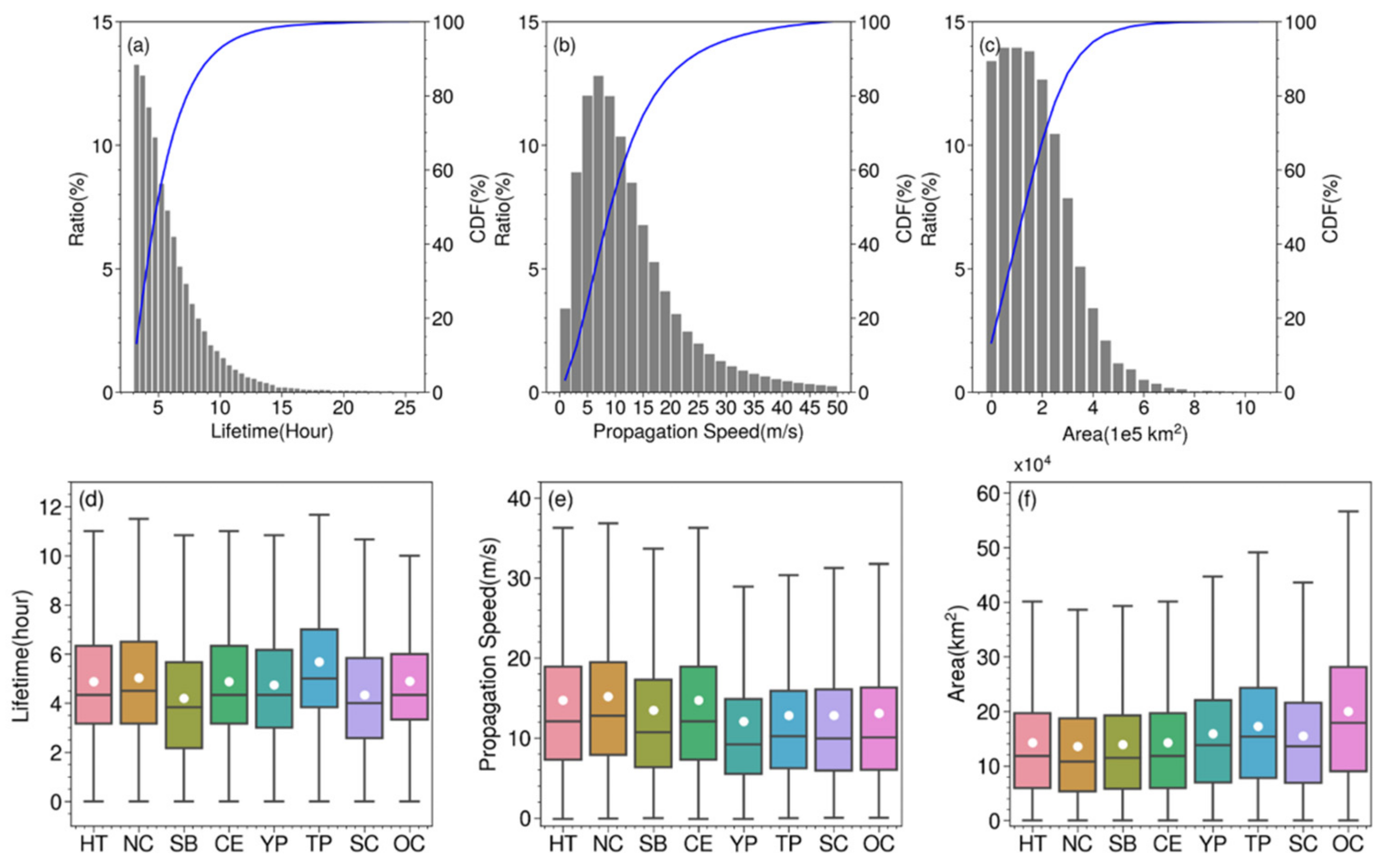
Figure 2a–c presents the frequency and cumulative distribution function (CDF) of convective systems lifetime, propagation speed and areas, respectively. The propagation speed was calculated by the haversine distance between the longitude and latitude pairs of the convection center in the two consecutive frames divided by the time difference. About 90% of the total deep convective systems over China and its vicinity have lifetimes less than 10 h, areas less than 4 × 10⁵ km2 and move slower than 20 m/s (Figure 2a–c). In Tibetan Plateau (TP), the deep convective systems have much longer lifetime than other regions, especially Sichuan Basin (SB) and South China (SC). In contrast, the convective systems have similar lifetime pattern over the other inland regions and ocean (Figure 2d). However, the mean propagation speed of convective systems in Tibetan Plateau (TP) and Yunnan-Guizhou Plateau (YP) smaller than Hetao (HT), North China (NC) and Central Eastern China (CE) (Figure 2e).
The mean propagation speed of convective systems are 15.2, 14.7, 12.9, 12.8 and 13.1 m/s in the North China (NC), Central Eastern China (CE), Tibetan Plateau (TP), South China (SC) and Ocean (OC), respectively. The mean propagation speed of all convective systems over Tibetan Plateau (TP) and Yunnan-Guizhou Plateau (YP) is less than those in Hetao (HT), North China (NC) and Central Eastern China (CE) (Figure 2e), particularly Sichuan Basin (SB), but fast moving storms with a propagation speed over 20 m/s are mainly located in Tibetan Plateau (TP) and South China (SC) (not shown), which indicates the existence of a significant number of very slow moving storms over the Tibetan Plateau (TP), Yunnan-Guizhou Plateau (YP) and South China (SC). Figure 2f shows the mean convective areas of convective systems in Tibetan Plateau (TP) and Oceans (OC) is larger than those in other regions. The similar areas patterns are exhibited in Hetao (HT), North China (NC), Central Eastern China (CE) and the Sichuan Basin (SB), which is smaller than those in Yunnan-Guizhou Plateau (YP) and South China (SC).

3.2. Cloud Top Vertical Velocity

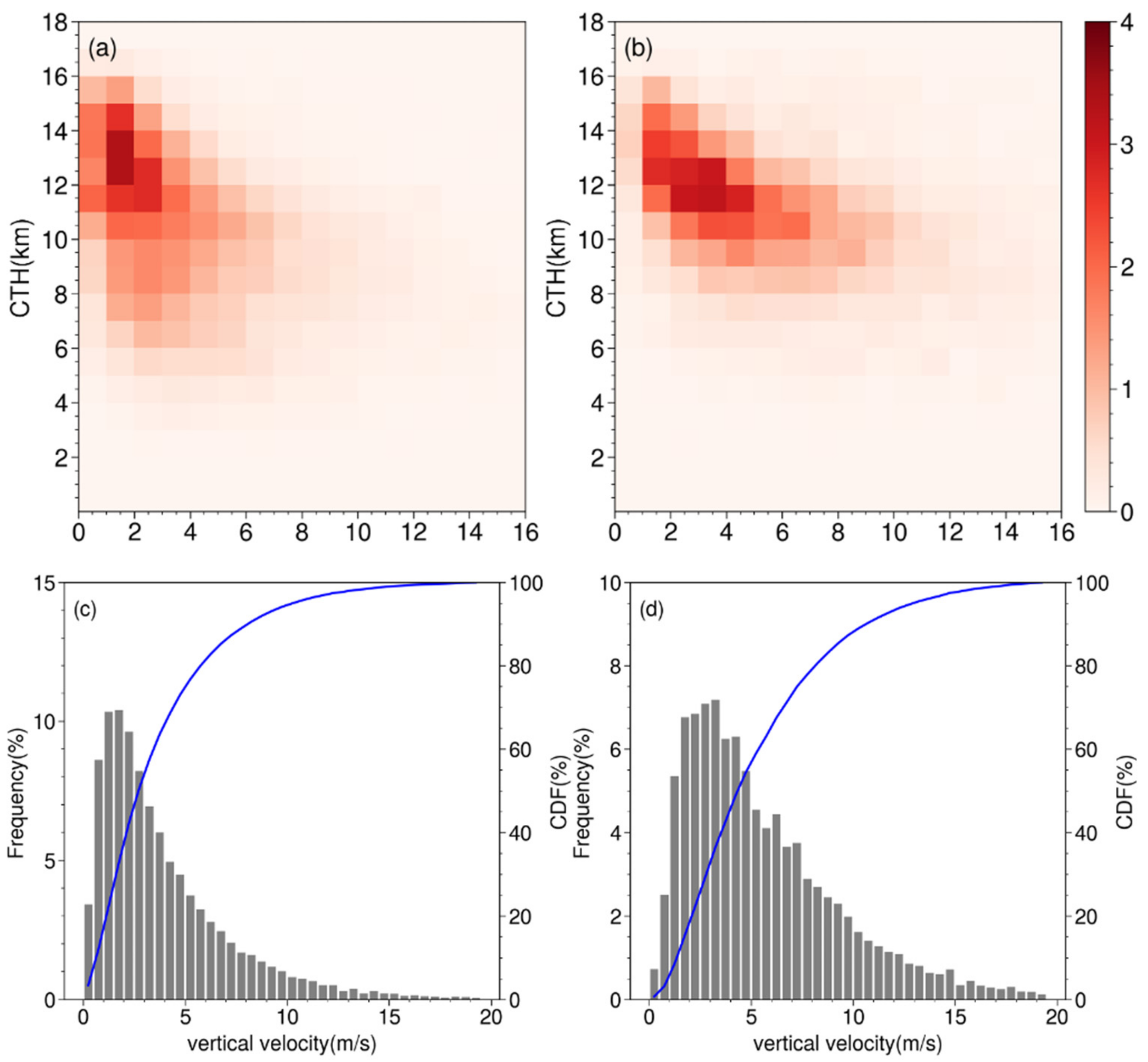
Figure 3 shows the vertical distribution of cloud top vertical velocity of the convective systems over land and ocean of the whole region of China and its vicinity. The results are normalized by the total number of samples, 26,385 for land and 10,455 for oceans. It is noted that the Himawari-8 satellite measurements used is at 5 km spatial intervals and 10 min time intervals, those of ERA5 reanalysis is 0.125° grid resolution and 60 min, but a typical convective core is about 1 km wide [59]. Therefore, the results only represent smoothed, relatively large-scale convective systems.
Figure 3a,b show that the frequency distribution of cloud-top vertical velocity tends to increase with height and reaches a maximum value at 12–14 km over land and 11–13 km over ocean. These statistical characteristics are consistent with previous studies over the United States [45,59]. The oceanic convective systems have stronger cloud-top vertical velocities than those over land. The oceanic convective systems gain a cloud-top vertical velocity of 1–8 m/s when their cloud tops reach 9–15 km height. Nevertheless, the convective systems over the land have weaker cloud-top vertical velocity (1–4 m/s). Overall, oceanic convection tends to gain stronger vertical motion at lower height than inland convection.
Figure 3c, d show the frequency and the cumulative distribution function (CDF) of the cloud-top vertical velocity for the inland and oceanic convective systems. The 25th and 75th percentile values of the vertical velocity are 1.6 and 5.2 m/s over land, and 2.7 and 7.5 m/s over ocean, respectively. In general, oceanic convection is more vigorous than inland convection.

3.3. Spatiotemporal Distribution of Deep Convective Systems

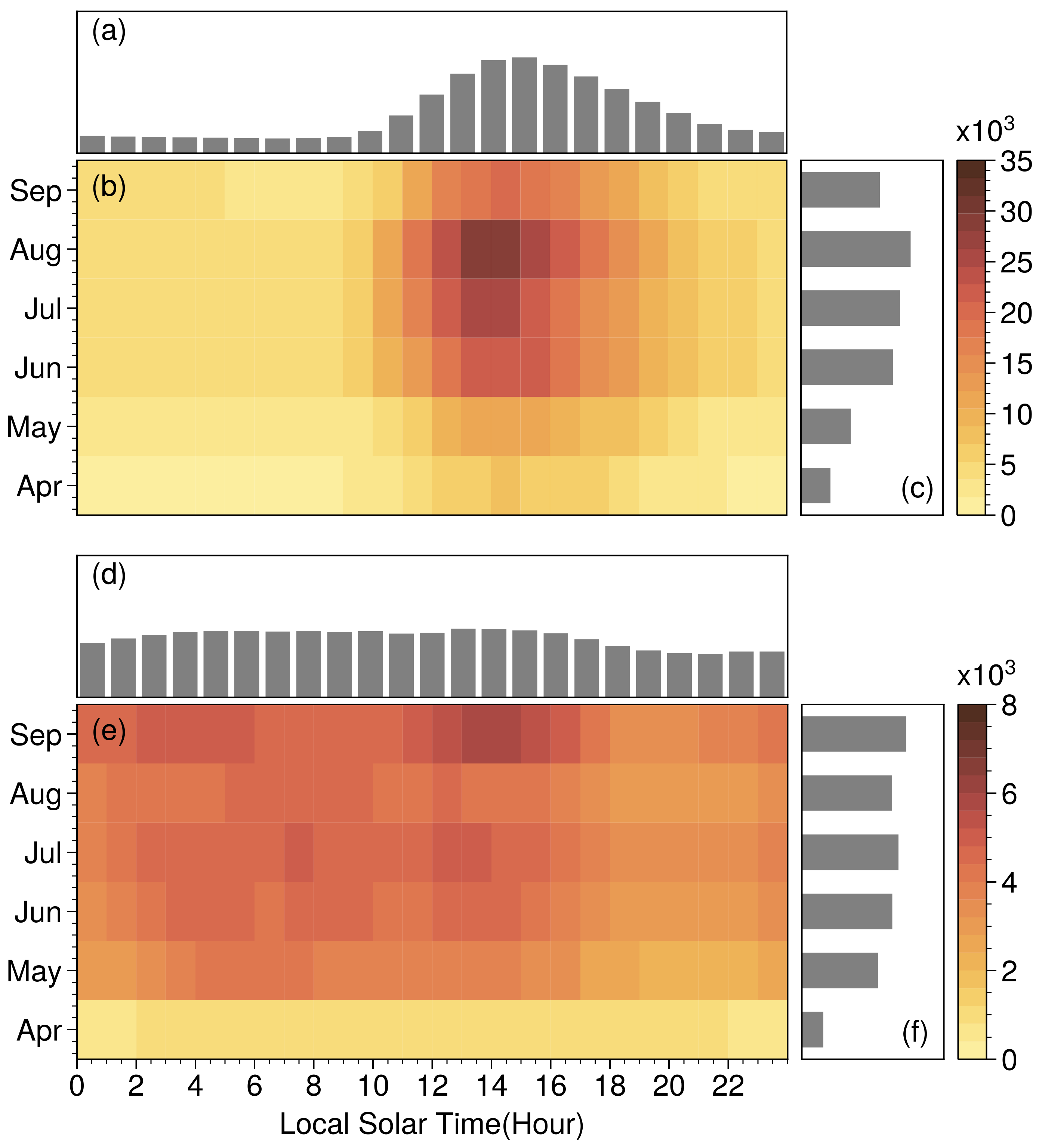
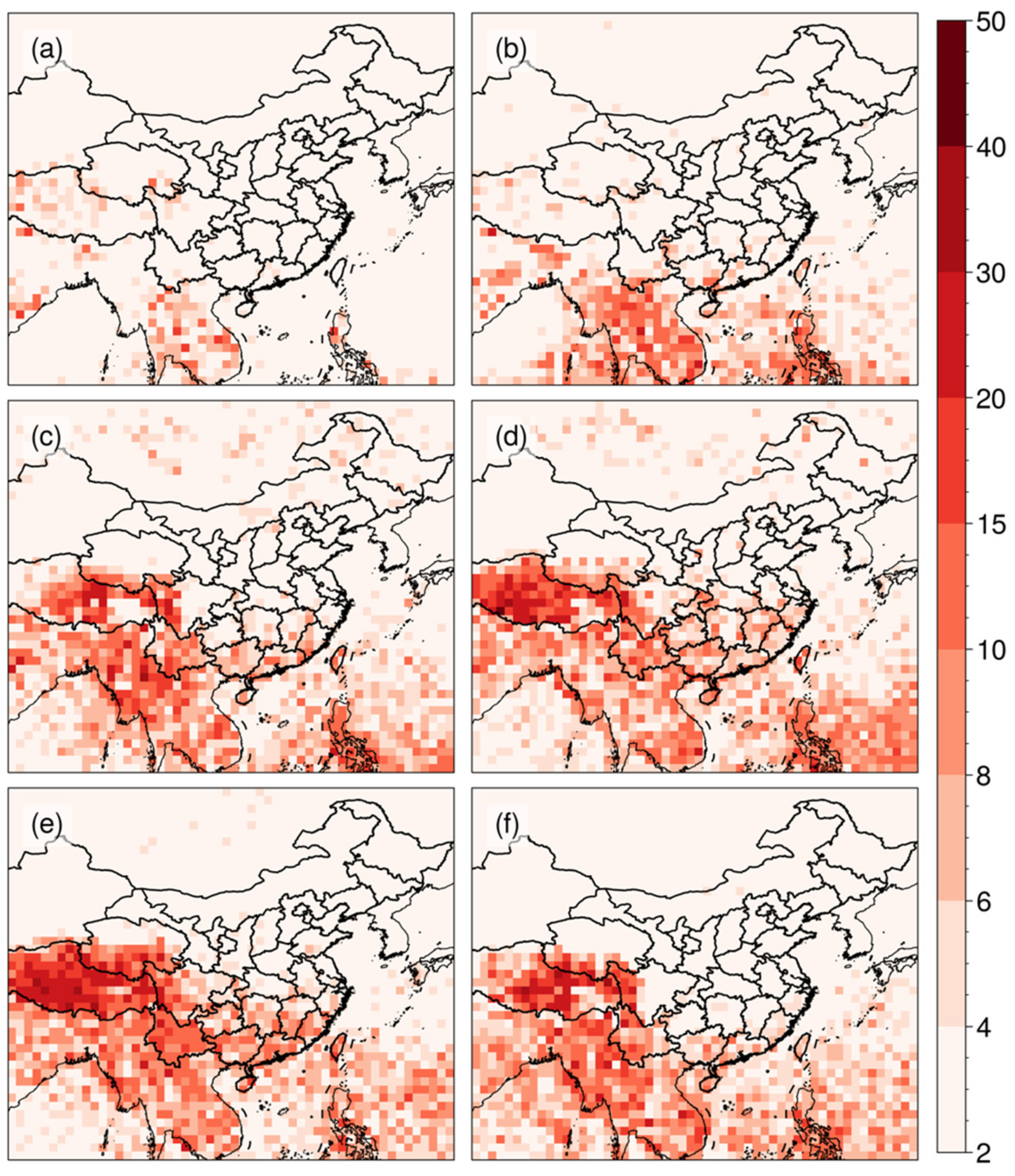
Deep convective systems identified during the warm seasons from 2016 to 2020 were accumulated on 1° × 1° grids to manifest their spatial distribution across China and its vicinity (Figure 4). The number of the convection storms varies significantly monthly (Figure 5). For the five-year warm-season period, the maximum number of deep convective systems was 10195, occurred in 2020, and the minimum was 8530, in 2019. Over the South China (SC), Central Eastern China (CE), Yunnan-Guizhou Plateau (YP) and Tibetan Plateau (TP), the convective systems of June, July and August account for more than 75% of the total deep convective systems in China and its vicinity. In June, deep convective systems are very active across the central Tibetan Plateau (TP), Yunnan-Guizhou Plateau (YP) and South China (SC), due to onset of monsoon in late May [41].
Figure 4 shows three local maxima centers in the southwestern, central and eastern Tibetan Plateau (TP) during July and August. This result is different from Hu et al. [43] who identified only two local maximum centers in the central and eastern Tibetan Plateau (TP). This discrepancy may be attributed to different approaches used to define convective systems. Hu et al. [42] defined a Tibetan Convective System with a criterion of cloud TBB < 245 K, whereas in the present study, the convective system initial formation threshold is 241–270 K. The multiple thresholds help to identify and track convection systems in their earlier stage than those can be captured in Hu et al. [42].
Occurrences of deep convective systems vary dramatically, seasonally and diurnally (Figure 5). Over land (Figure 5a–c), deep convection presents strong diurnal variation. Most convection developed between 10 and 20 LST, with a peak 13–14 LST. Deep convection grows from April to September and decreases into October. Over oceans (Figure 5d–f), both diurnal and monthly variations of the deep convection are much more moderate than those over land.
A typical convective system has three stages: initiation, maturity and dissipation [60]. Our convection identification and tracking method allows us to identify the convective systems in all of the three stages. Figure 6 exhibits the statistical results of the diurnal variation of the convective systems at their initiation, maximum maturity and dissipation stages, respectively. Convective systems on land and ocean present dramatically different diurnal features. Over land, the diurnal variation of the occurrences of the initiation, maturity and dissipation of the convective systems exhibits a unimodal pattern with the peaks at 13, 16 and 18 LST, respectively. In contrast, no significant diurnal variation pattern can be identified for the convection over ocean although the convective activity decreases slightly from 16 to 22 LST. The oceanic convective system keeps active from night to afternoon (~14 LST) due to sea surface temperature forcing. Over land, the CI occurrence dramatically increases from 10 to 13 LST then gradually weakens (Figure 6), mostly in response to the changes in solar heating.

3.4. Regional Features and Temporal Variability of DCSI

Convective initiation is an important aspect of convective systems because when and where convection is triggered essentially affects the subsequent occurrence of organized convection system and associated heavy rainfall [27]. Figure 7 shows that there are significant monthly variations of DCSI over China and its vicinity. A large proportion of DCSI occurs in Tibetan Plateau (TP), Yunnan-Guizhou Plateau (YP), South China (SC), Myanmar and Thailand (Figure 7). DCSI occurrences increase from May to June, with a sharp jump in June, and reach a peak in July and/or August over land, particularly over Tibetan Plateau (TP), Yunnan-Guizhou Plateau (YP) and South China (SC) (Figure 7). The DCSI in these regions dramatically increases in June owing to the onset of summer monsoon in late May [42,61]. DCSI occurrences gradually spread northward from May to August along with the East Asian summer monsoon advancing northward, which pushes convective activity northward [62].
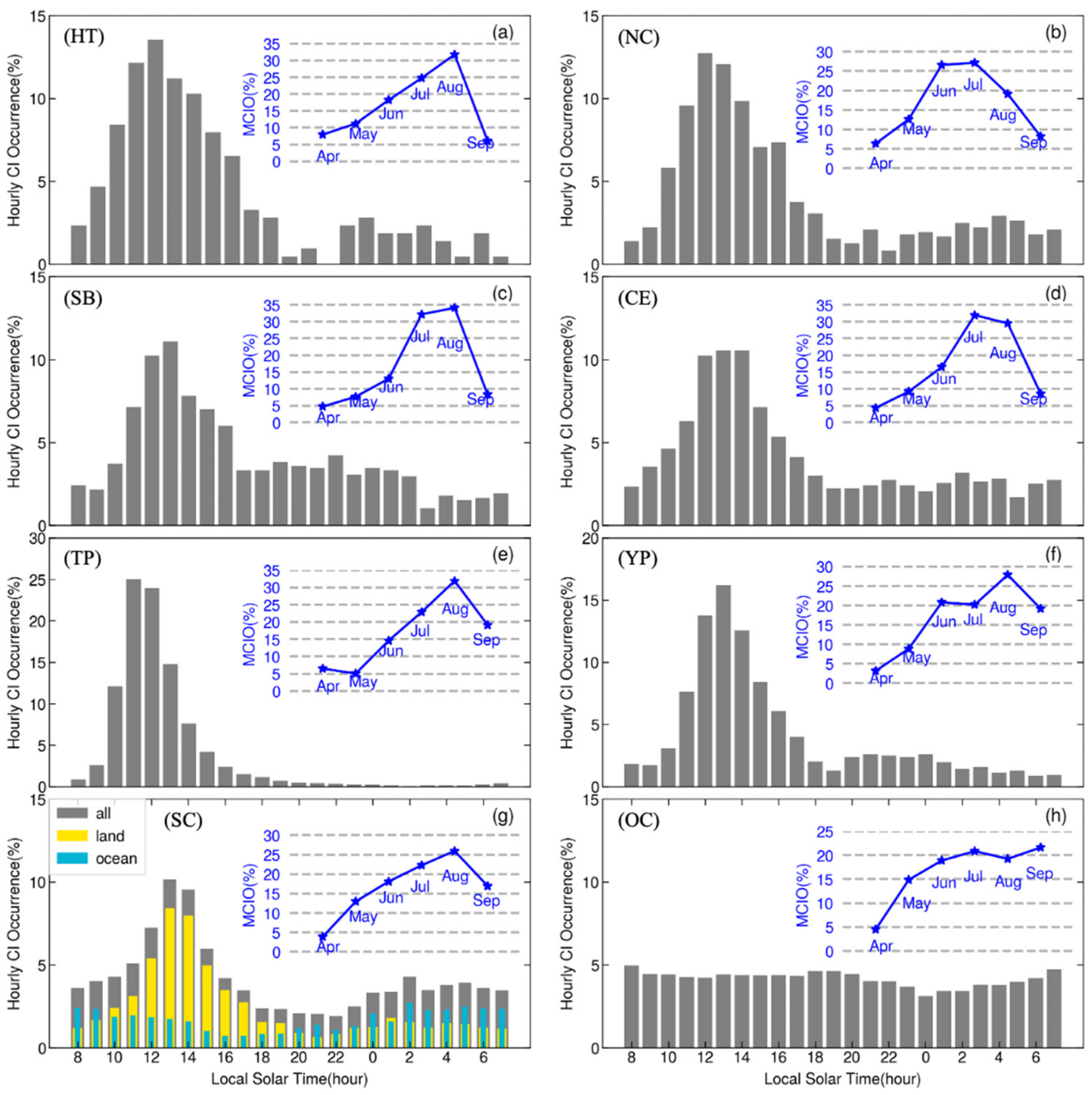
Figure 8 exhibits the sub-seasonal and diurnal variation of DCSI for the 7 selected inland sub-regions and the ocean area in the study domain. The monthly variation of DCSI occurrences over land is similar to those over ocean, but their diurnal variations are significantly different. In general, DCSI occurrences increase from April to May, and the convective activity sharply increases in June/July, particularly North China (NC) and Central Eastern China (CE) (Figure 7 and Figure 8, respectively). DCSI occurrences reach a peak in June and July over Hetao (HT), North China (NC) and Central Eastern China (CE), but in August over Tibetan Plateau (TP), Yunnan-Guizhou Plateau (YP) and South China (SC). By September, the convective systems start to decline quickly in association with the seasonal change of the synoptic weather regimes.
DCSI over all inland regions presents a feature of quick ramping up in the morning in response to the solar radiation heating [23,27,31,38,43]. The overall characteristics of DCSI diurnal variation over these regions is similar to the DCSI statistics in other midlatitude areas [23,63,64]. However, the rate and time of the morning convection ramping up are quite different among these regions. The convective systems over Tibetan Plateau (TP) develop faster and earlier in the morning than other regions, with a peak activity at 11 LST. In Sichuan Basin (SB), South China (SC), Yunnan-Guizhou Plateau (YP) and Central Eastern China (CE), the peaks of DCSI occur at 13 LST, which is 2 h later than those over Tibetan Plateau (TP). The peak occurrence time of convective systems over Hetao (HT) and North China (NC) are 12 LST.
Unlike the those in the other regions, DCSI over Tibetan Plateau (TP) developed very fast in the morning and ceased quickly by early afternoon as well, following a sharp unimodal diurnal pattern with very few nocturnal occurrences. In contrast, there are significant early-night DCSI occurrences in Sichuan Basin (SB) and Yunnan-Guizhou Plateau (YP). Furthermore, significant DCSI develops in late night and early morning in Hetao (HT), North China (NC), Central Eastern China (CE) and South China (SC). DCSI in South China exhibits a clear ramping-down in the evening and ramping up by 22 LST, forming an abundant DCSI period between 02 LST and 08 LST.
DCSI averaged over all oceans (i.e., the white areas in Figure 1a) does not have significant diurnal variation (Figure 8h). During the daytime (from 08 to 20 LST), the oceanic DCSI activities keep nearly constant. Staring from 20 LST, DCSI is dipping slightly, reaching a minimum by mid-night, and then, gradually recovered. It keeps inactive between 16 and 19 LST, and then gradually ramps up to the mean level by midnight. The nighttime DCSI ramping-up is associated with the development of land breezes that result in flow convergence over ocean, and the atmosphere cooling due to long-wave radiation cooling that destabilizes the atmospheric boundary layer.
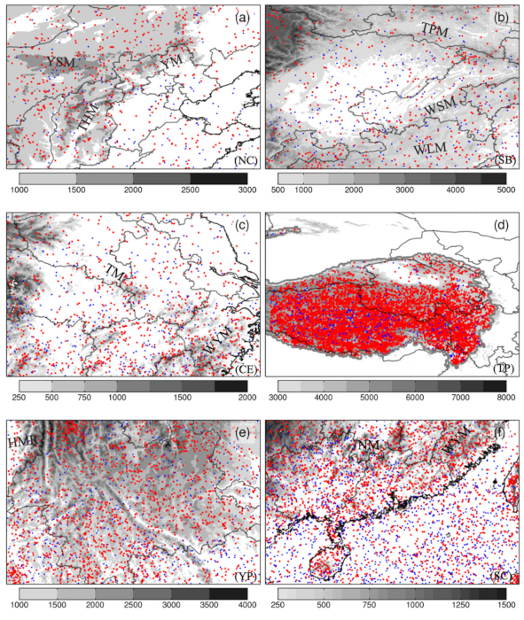
Figure 9 compares daytime and nighttime DCSI occurrences for the selected regions. Overall, over 70% of the total DCSI occurrences in Hetao (HT) and North China (NC) (Figure 9a) take place during the daytime (07-19 LST). They are primarily initiated over or near the mountains, such as Yinshan Mountains (YSM), Taihang Mountains (THM) and Yanshan Mountains (YM). Chen et al. [13] found that the wind regimes at 500 hPa are responsible to convection initiating and developing over the foothills and plains, and over the mountains located to the northwest in early afternoon. There are enhanced DCSI activities during nighttime (19-07 LST) in the eastern plain and Bohai Sea (Figure 9a), which is consistent with the result by Chen et al. [38]. Figure 9c shows that a large proportion of DCSI occurs in and near the mountains (e.g., Ta-pieh Mountains (TM), Mount. Wuyi (WYM) etc.) during daytime over Central Eastern China (CE). Huang et al. [43] found that DCSI primarily occurs in areas with remarkable underlying inhomogeneity (e.g., mountain, water, and mountain-water areas). About 25% of DCSI occurrences take place in the plains (low elevation) regions during the nighttime.
Different from North China (NC) and Central Eastern China (CE), Sichuan Basin (SB) is located to the east of Tibetan Plateau (TP), surrounded by Wushan Mountains (WSM), Ta-pa Mountain (TPM), and Yunnan-Guizhou Plateau (YP). Daytime DCSI is mostly active the east part of Tibetan Plateau (TP), Ta-pa Mountains (TPM), Wushan Mountains (WSM), and Wuling Mountains (WLM). However, in nighttime, a large proportion of DCSI occurs in the basin and other relative lower elevation regions (Figure 9b). This phenomenon is due to the special regional and local dynamic and thermodynamic circulations over Sichuan Basin and its vicinity.
DCSI occurrences over Tibetan Plateau (TP) dramatically increase from May to August, along with the onset of summer monsoon [42]. From June to July, the local maxima of DCSI occurrences moves from the central region to the southwestern region, and then, gradually moves eastward over Tibetan Plateau (TP) during July and August. Overall, in this region, 95% of the total DCSI occurrences take place during the daytime (06-20 LST). In contrast, the sub-seasonal and diurnal variation of DCSI in Yunnan-Guizhou Plateau is similar to those in Tibetan Plateau (TP), but the percentage of nocturnal DCSI is much higher. The DCSI in Yunnan-Guizhou Plateau (YP) mainly develops to the southeast of Tibetan Plateau (TP), and along with the Hengduan Mountain Range (HMR) during daytime. However, during nighttime, DCSI increases near the low elevation region, particularly in the region close to the national boundaries of Yunnan Province and Myanmar.
Across South China (SC), a majority of the DCSI events are observed in tropical island, peninsula, and coastal regions. In particular, the DCSI occurrences sharply increase in tropical island and coastal regions from June to August, and have a peak in August (Figure 7 and Figure 8g). Figure 9 shows that DCSIs primarily takes place and mainly located near the mountains during daytime, indicating a primary role of orographic lifting in this region, but at night, it preferentially occurs near the coastlines (Figure 7, Figure 8g and Figure 9f). Both large-scale and small-scale terrain have an important influence on DCSI development [65]. In addition, the DCSI activity expands further northward from July to August (Figure 7), corresponding to the moist monsoon flows [6,27]. Obviously, the summer monsoon, land-sea breeze circulations and terrain work together to drive the monthly and diurnal variations of DCSI in this region [39].

4. Summary and Discussion

In this paper, warm-season deep convective systems and convective initiation during 2016–2020 over China and its vicinity are identified and tracked based on measurements of Himawari-8 and the hourly ERA5 reanalysis. The lifecycles, sizes, propagation properties, and cloud top vertical velocity of the convective systems, along with the occurrence of DCSI, were statistically analyzed. In addition, the sub-seasonal and diurnal variations of DCSI events over Tibetan Plateau (TP), Yunnan-Guizhou Plateau (YP), South China (SC), Sichuan Basin (SB), Central Eastern China (CE) and North China (NC), and oceans were analyzed.
The average life span, area coverage, and propagation speed of deep convective systems over China and its vicinity is 5.8 h, 2 × 10⁵ km2 and 13.2 m/s, respectively. The maxima of occurrence frequency of convective systems are mainly located in the central and eastern Tibetan Plateau (TP), Yunnan-Guizhou Plateau (YP) and South China (SC). Convective system occurrences tend to reach a maximum in August and at 14 LST. In the central and western Tibetan Plateau (TP), Central Eastern China (CE) and North China (NC), the convective systems are mainly eastward moving type, but over Yunnan-Guizhou Plateau (YP) and South China (SC), most convective systems are southwestward and westward moving types. The convective systems with faster propagation speeds (over 20 m/s) are mainly located in the Tibetan Plateau (TP), followed by those in South China (SC). However, the mean propagation speed of the convective systems over Tibetan Plateau (TP) is lower than those in the other regions, such as North China (NC) and Central Eastern China (CE). Oceanic convection is featured by stronger cloud top vertical velocity at lower cloud top height than the convection over land.
DCSI are much more frequent in Tibetan Plateau (TP), Yunnan-Guizhou Plateau (YP) and South China (SC) than the other part of China. There are three maximum DCSI centers, located in the central, southwestern and eastern Tibetan Plateau (TP), respectively. DCSI is very active over the coastal mountains, primarily due to the onshore monsoon flows, sea breezes, and coastal topography [25]. A large proportion of DCSI occurs in the mountains, such as Taihang Mountains (THM), Yanshan Mountains (YM) and Yinshan Mountains (YSM) over North China (NC), Tapa Mountains (TPM), Wushan Mountains (WSM), Wuling Mountains (WLM) over the Sichuan Basin (SB). The DCSI occurrence exhibits a significant seasonal and diurnal variation over land, gradually increasing and reaching to a maximum in June in North China (NC) and Central Eastern China (CE) but in August over Tibetan Plateau (TP), Yunnan-Guizhou Plateau (YP) and South China (SC). The DCSI occurrence grows in the morning and peaks at 11 LST over Tibetan Plateau (TP), but at 12 or 13 LST in the other regions (e.g., North China (NC), Sichuan Basin (SB), Central Eastern China (CE), Yunnan-Guizhou Plateau (YP) and South China (SC)). The nocturnal DCSI preferably occurs near the coastlines, plains and basins.
It should be pointed out that the results from this study need to be explained with some care. Firstly, there may be some biases in infrared brightness temperature. Secondly, the measurements do not resolve subpixel-scale variation of the cloud fraction emissivity, and atmospheric attenuation may result in some errors [45]. The convective cloud top vertical velocity estimated in this study should be regarded as a horizontally and temporally averaged vertical velocity of convective systems comprised of multiple turrets within the analysis grids, rather than the maximum vertical velocity in convective cores.
Previous studies using satellite measurements [20,21,41,42,43] to investigate the characteristics of convective systems in China, suffered from the coarser data spatial-temporal resolution or limited to much smaller regions. In this study, five-year high spatial-temporal resolution Himawari-8 data were used to achieve refined statistical characteristics of the temporal and spatial structure of convective systems over China and its vicinity, including complex terrain. This work also analyzed DCSI, an important convection parameter for convection prediction.
Currently, forecasting DCSI timing and location is a great challenge, thus affecting the predictability of subsequent convection and QPF [23,66]. Therefore, it is necessary to further to improve the understanding of convective initiation for nowcasting and forecasting the convective system development. The recent advances of the geostationary satellite capabilities (e.g., Himawari-8/9, FY-4A/B, GOES series, etc.), weather radars or other ground-based observing systems provide us new opportunities to further study the characteristics of DCSI and improve DCSI forecast. Although the genesis environment of mesoscale convective systems is very similar and many convective systems display similar dynamic and thermodynamic structures around the world [67], the understanding of convective initiation in different regions, particularly in complex terrain, remains a great challenge [37,39]. Further research is needed to explore the impact of the atmospheric environment factors on the convective systems, the direct and indirect influence of dynamic and thermodynamic forcing from land surface, terrain and sea breezes, and in particular, their daytime and nighttime initiation, by using these modern observing systems, as well as high-resolution numerical weather models and machine learning/deep learning technologies.

Author Contributions

Conceptualization, Y.L. (Yang Li), Y.L. (Yubao Liu), and Y.C.; investigation, Y.L. (Yang Li), Y.L. (Yubao Liu), and B.C.; methodology, Y.L. (Yang Li), Y.L. (Yubao Liu), W.W.; software, Y.L. (Yang Li) and X.Z.; data curation, Y.L. (Yang Li) and X.Z.; writing original draft preparation, Y.L. (Yang Li); writing—review and editing, Y.L. (Yang Li), and Y.L. (Yubao Liu); visualization, Y.L. (Yang Li), Z.S. and Z.H.; funding acquisition, Y.L. (Yubao Liu). All authors have read and agreed to the published version of the manuscript.

Funding

This research was funded by the State Grid of Corporation of China Science and Technology Project, grant number 5200-201955490A-0-0-00.

Institutional Review Board Statement

Not applicable.

Informed Consent Statement

Not applicable.

Data Availability Statement

The Himawari-8 geostationary satellite data, including L1b and L2 products can be accessed from Japan Meteorological Agency (JMA) (https://www.eorc.jaxa.jp/ptree). The hourly ERA-5 reanalysis data can be accessed from the Copernicus Climate Change Service Climate Data Store (https://cds.climate.copernicus.eu). The tracking convective systems package can be downloaded from GitHub (https://github.com/climate-processes/tobac/tree/v2.0-dev). The last accessed date is 29 April 2021 for all data and tools.

Acknowledgments

We thank Shuanglei Feng for his suggestions on the methods used in this paper and all contributors of Python packages used in this paper, especially matplotlib [68], ProPlot [69] and Satpy [70].

Conflicts of Interest

The authors declare no conflict of interest.

References

  1. Houze, R.A., Jr.; Wilton, D.C.; Smull, B.F. Monsoon convection in the Himalayan region as seen by the TRMM precipitation radar. Q. J. R. Meteorol. Soc. 2007, 133, 1389–1411. [Google Scholar] [CrossRef]
  2. Chen, J.; Zheng, Y.; Zhang, X.; Zhu, P. Distribution and diurnal variation of warm-season short-duration heavy rainfall in relation to the MCSs in China. Acta Meteorol. Sin. 2013, 27, 868–888. [Google Scholar] [CrossRef]
  3. Yao, Y.Q.; Yu, X.D.; Zhang, Y.J.; Zhou, Z.J.; Xie, W.S.; Lu, Y.Y.; Yu, J.L.; Wei, L.X. Climate analysis of tornadoes in China. J. Meteorol. Res. 2015, 29, 359–369. [Google Scholar] [CrossRef]
  4. Liu, D.X.; Sun, M.Y.; Su, D.B.; Xu, W.J.; Yu, H.; Chen, Y.C. A five-year climatological lightning characteristics of linear mesoscale convective systems over North China. Atmos. Res. 2021, 256, 105580. [Google Scholar] [CrossRef]
  5. Li, X.F.; Zhang, Q.H.; Zou, T.; Lin, J.P.; Kong, H.; Ren, Z.H. Climatology of hail frequency and size in China, 1980–2015. J. Appl. Meteorol. Climatol. 2018, 57, 875–887. [Google Scholar] [CrossRef]
  6. Bai, L.Q.; Meng, Z.Y.; Sueki, K.; Chen, G.X.; Zhou, R.L. Climatology of tropical cyclone tornadoes in China from 2006 to 2018. Sci. China Earth Sci. 2020, 63, 37–51. [Google Scholar] [CrossRef]
  7. Horel, J.D.; Hahmann, A.N.; Geisler, J.E. An investigation of the annual cycle of convective activity over the tropical Americas. J. Clim. 1989, 2, 1388–1403. [Google Scholar] [CrossRef] [Green Version]
  8. Zhang, X.B.; Hogg, W.D.; Mekis, É. Spatial and temporal characteristics of heavy precipitation events over Canada. J. Clim. 2001, 14, 1923–1936. [Google Scholar] [CrossRef]
  9. Ashley, W.S.; Mote, T.L.; Dixon, P.G.; Trotter, S.L.; Powell, E.J.; Durkee, J.D.; Grundstein, A.J. Distribution of mesoscale convective complex rainfall in the United States. Mon. Weather Rev. 2003, 131, 3003–3017. [Google Scholar] [CrossRef]
  10. Feng, Z.; Houze, R.A.; Leung, L.R.; Song, F.; Hardin, J.C.; Wang, J.Y.; Gustafson, W.I.; Homeyer, C.R. Spatiotemporal characteristics and large-scale environments of mesoscale convective systems east of the Rocky Mountains. J. Clim. 2019, 32, 7303–7328. [Google Scholar] [CrossRef] [Green Version]
  11. Meng, Y.N.; Sun, J.H.; Zhang, Y.C.; Fu, S.M. A 10-Year Climatology of Mesoscale Convective Systems and Their Synoptic Circulations in the Southwest Mountain Area of China. J. Hydrometeorol. 2021, 22, 23–41. [Google Scholar] [CrossRef]
  12. Xu, W.X. Precipitation and convective characteristics of summer deep convection over East Asia observed by TRMM. Mon. Weather Rev. 2013, 141, 1577–1592. [Google Scholar] [CrossRef]
  13. Chen, X.C.; Zhao, K.; Xue, M. Spatial and temporal characteristics of warm season convection over Pearl River Delta region, China, based on 3 years of operational radar data. J. Geophys. Res. Atmos. 2014, 119, 12–447. [Google Scholar] [CrossRef]
  14. Yang, X.R.; Fei, J.F.; Huang, X.G.; Cheng, X.P.; Carvalho, L.M.V.; He, H.R. Characteristics of mesoscale convective systems over China and its vicinity using geostationary satellite FY2. J. Clim. 2015, 28, 4890–4907. [Google Scholar] [CrossRef]
  15. Mai, Z.; Fu, S.M.; Sun, J.H.; Hu, L.; Wang, X.M. Key statistical characteristics of the mesoscale convective systems generated over the Tibetan Plateau and their relationship to precipitation and southwest vortices. Int. J. Climatol. 2021, 41, E875–E896. [Google Scholar] [CrossRef]
  16. Qian, T.T.; Zhao, P.; Zhang, F.Q.; Bao, X.H. Rainy-season precipitation over the Sichuan basin and adjacent regions in southwestern China. Mon. Weather Rev. 2015, 143, 383–394. [Google Scholar] [CrossRef]
  17. He, Z.W.; Zhang, Q.H.; Bai, L.Q.; Meng, Z.Y. Characteristics of mesoscale convective systems in central East China and their reliance on atmospheric circulation patterns. Int. J. Climatol. 2017, 37, 3276–3290. [Google Scholar] [CrossRef]
  18. Kukulies, J.; Chen, D.; Curio, J. The Role of Mesoscale Convective Systems in Precipitation in the Tibetan Plateau region. Earth Space Sci. Open Arch. ESSOAr 2020. [Google Scholar] [CrossRef]
  19. Ma, R.Y.; Sun, J.H.; Yang, X.L. A 7-Yr Climatology of the Initiation, Decay, and Morphology of Severe Convective Storms during the Warm Season over North China. Mon. Weather Rev. 2021, 149, 2599–2612. [Google Scholar] [CrossRef]
  20. Laing, A.G.; Fritsch, J.M. The global population of mesoscale convective complexes. Q. J. R. Meteorol. Soc. 1997, 123, 389–405. [Google Scholar] [CrossRef]
  21. Zheng, Y.G.; Chen, J.; Zhu, P.J. Climatological distribution and diurnal variation of mesoscale convective systems over China and its vicinity during summer. Chin. Sci Bull. 2008, 53, 1574–1586. [Google Scholar] [CrossRef] [Green Version]
  22. Ziegler, C.L. Deep convection initiation: State of the science, limits of understanding, and future directions. Presented at the 94th American Meteorological Society Annual Meeting, American Meteorological Society, Atlanta, GA, USA, 5 February 2014. [Google Scholar]
  23. Weckwerth, T.M.; Wilson, J.W.; Hagen, M.; Emerson, T.J.; Pinto, J.O.; Rife, D.L.; Grebe, L. Radar climatology of the COPS region. Q. J. R. Meteorol. Soc. 2011, 137, 31–41. [Google Scholar] [CrossRef] [Green Version]
  24. Kaltenboeck, R.; Steinheimer, M. Radar-based severe storm climatology for Austrian complex orography related to vertical wind shear and atmospheric instability. Atmos. Res. 2015, 158, 216–230. [Google Scholar] [CrossRef]
  25. Reif, D.W.; Bluestein, H.B. A 20-year climatology of nocturnal convection initiation over the central and southern Great Plains during the warm season. Mon. Weather Rev. 2017, 145, 1615–1639. [Google Scholar] [CrossRef]
  26. Huang, Y.P.; Meng, Z.Y.; Li, J.; Li, W.B.; Bai, L.Q.; Zhang, M.R.; Wang, X. Distribution and Variability of Satellite-Derived Signals of Isolated Convection Initiation Events Over Central Eastern China. J. Geophys. Res. Atmos. 2017, 122, 11–357. [Google Scholar] [CrossRef]
  27. Bai, L.Q.; Chen, G.X.; Huang, L. Convection initiation in monsoon coastal areas (South China). Geophys. Res. Lett. 2020, 47, e2020GL087035. [Google Scholar] [CrossRef]
  28. Mecikalski, J.R.; Williams, J.K.; Jewett, C.P.; Ahijevych, D.; LeRoy, A.; Walker, J.R. Probabilistic 0–1-h convective initiation nowcasts that combine geostationary satellite observations and numerical weather prediction model data. J. Appl. Meteorol. Climatol. 2015, 54, 1039–1059. [Google Scholar] [CrossRef] [Green Version]
  29. Wilson, J.W.; Roberts, R. Summary of convective storm initiation and evolution during IHOP: Observational and modeling perspective. Mon. Weather Rev. 2006, 134, 23–47. [Google Scholar] [CrossRef]
  30. Wilson, J.W.; Schreiber, W.E. Initiation of convective storms at radar-observed boundary-layer convergence lines. Mon. Weather Rev. 1986, 114, 2516–2536. [Google Scholar] [CrossRef] [Green Version]
  31. Weckwerth, T.M.; Parsons, D.B. A review of convection initiation and motivation for IHOP_2002. Mon. Weather Rev. 2006, 134, 5–22. [Google Scholar] [CrossRef]
  32. Wulfmeyer, V.; Behrendt, A.; Kottmeier, C.; Corsmeier, U.; Barthlott, C.; Craig, G.C.; Hagen, M.; Althausen, D.; Aoshima, F.; Arpagaus, M.; et al. The Convective and Orographically induced Precipitation Study: A research and development project of the World Weather Research Program for improving quantitative precipitation forecasting in low-mountain regions. Bull. Am. Meteorol. Soc. 2011, 89, 1477–1486. [Google Scholar] [CrossRef]
  33. Geerts, B.; Parsons, D.; Ziegler, C.L.; Weckwerth, T.M.; Biggerstaff, M.I.; Clark, R.D.; Coniglio, M.C.; Demoz, B.B.; Ferrare, A.; Gallus, W.A.; et al. The 2015 plains elevated convection at night field project. Bull. Am. Meteorol. Soc. 2017, 98, 767–786. [Google Scholar] [CrossRef]
  34. Luo, Y.L.; Zhang, R.H.; Wan, Q.L.; Wang, B.; Wong, W.K.; Hu, Z.Q.; Jou, B.J.D.; Lin, Y.L.; Johnson, R.H.; Chang, C.P.; et al. The southern China monsoon rainfall experiment (SCMREX). Bull. Am. Meteorol. Soc. 2017, 98, 999–1013. [Google Scholar] [CrossRef]
  35. Luo, Y.L.; Gong, Y.; Zhang, D.L. Initiation and organizational modes of an extreme-rain-producing mesoscale convective system along a mei-yu front in east China. Mon. Weather Rev. 2014, 142, 203–221. [Google Scholar] [CrossRef] [Green Version]
  36. Hua, S.F.; Xu, X.; Chen, B.J. Influence of multiscale orography on the initiation and maintenance of a precipitating convective system in North China: A case study. J. Geophys. Res. Atmos. 2020, 125, e2019JD031731. [Google Scholar] [CrossRef]
  37. Du, Y.; Chen, G.X. Heavy rainfalls associated with double low-level jets over southern China. Part II: Convection initiation. Mon. Weather Rev. 2019, 147, 543–565. [Google Scholar] [CrossRef]
  38. Chen, M.X.; Wang, Y.C.; Gao, F.; Xiao, X. Diurnal variations in convective storm activity over contiguous North China during the warm season based on radar mosaic climatology. J. Geophys. Res. Atmos. 2012, 117, 1–14. [Google Scholar] [CrossRef] [Green Version]
  39. Zhu, L.; Bai, L.Q.; Chen, G.X.; Sun, Q.; Meng, Z.Y. Convection Initiation Associated with Ambient Winds and Local Circulations Over a Tropical Island in South China. Geophys. Res. Lett. 2021, 48, e2021GL094382. [Google Scholar] [CrossRef]
  40. Zhang, Q.; Ren, J.X.; Xiao, H.R.; Wang, J.J.; Xiao, D.X. Characteristics of MCC from Convective Initiation to Mature Stage Over the Sichuan Basin Based on FY-4A Satellite Data. Chin. J. Atmos. Sci. 2021, 45, 863–873. [Google Scholar] [CrossRef]
  41. Li, Y.D.; Wang, Y.; Yang, S.; Hu, L.; Gao, S.T.; Fu, R. Characteristics of summer convective systems initiated from Tibetan Plateau Part I: Origin, track, development and precipitation. J. Appl. Meteorol. Climatol. 2008, 47, 2679–2695. [Google Scholar] [CrossRef] [Green Version]
  42. Hu, L.; Deng, D.F.; Gao, S.T.; Xu, X.D. The seasonal variation of Tibetan convective systems: Satellite observation. J. Geophys. Res. Atmos. 2016, 121, 5512–5525. [Google Scholar] [CrossRef]
  43. Hu, L.; Deng, D.F.; Xu, X.D.; Zhao, P. The regional differences of Tibetan convective systems in boreal summer. J. Geophys. Res. Atmos. 2017, 122, 7289–7299. [Google Scholar] [CrossRef]
  44. Luo, Z.Z.J.; Jeyaratnam, J.; Iwasaki, S.; Takahashi, H.; Anderson, R. Convective vertical velocity and cloud internal vertical structure: An A-Train perspective. Geophys. Res. Lett. 2014, 41, 723–729. [Google Scholar] [CrossRef]
  45. Hamada, A.; Takayabu, Y.N. Convective cloud top vertical velocity estimated from geostationary satellite rapid-scan measurements. Geophys. Res. Lett. 2016, 43, 5435–5441. [Google Scholar] [CrossRef] [Green Version]
  46. Lucas, C.; Zipser, E.J.; Lemone, M.A. Vertical velocity in oceanic convection off tropical Australia. J. Atmos. Sci. 1994, 51, 3183–3193. [Google Scholar] [CrossRef]
  47. Jorgensen, D.P.; LeMone, M.A. Vertical velocity characteristics of oceanic convection. J. Atmos. Sci. 1989, 46, 621–640. [Google Scholar] [CrossRef] [Green Version]
  48. May, P.T.; Rajopadhyaya, D.K. Vertical velocity characteristics of deep convection over Darwin, Australia. Mon. Weather Rev. 1999, 127, 1056–1071. [Google Scholar] [CrossRef]
  49. Hersbach, H.; Bell, B.; Berrisford, P.; Hirahara, S.; Horányi, A.; Muñoz-Sabater, J.; Nicolas, J.; Peubey, C.; Radu, R.; Schepers, D.; et al. The ERA5 global reanalysis. Q. J. R. Meteorol. Soc. 2020, 146, 1999–2049. [Google Scholar] [CrossRef]
  50. Maddox, R.A. Mesoscale convective complexes. Bull. Am. Meteorol. Soc. 1980, 61, 1374–1387. [Google Scholar] [CrossRef]
  51. Heikenfeld, M.; Marinescu, P.J.; Christensen, M.; Watson-Parris, D.; Senf, F.; van den Heever, S.C.; Stier, P. Tobac 1.2: Towards a Flexible Framework for Tracking and Analysis of Clouds in Diverse Datasets. Geosci. Model. Dev. 2019, 12, 4551–4570. [Google Scholar] [CrossRef] [Green Version]
  52. Soille, P.J.; Ansoult, M.M. Automated Basin Delineation from Digital Elevation Models Using Mathematical Morphology. Signal Process. 1990, 20, 171–182. [Google Scholar] [CrossRef]
  53. Allan, D.; Caswell, T.; Keim, N.; van der Wel, C. TrackPy. Zenodo 2019. [Google Scholar] [CrossRef]
  54. Ai, Y.; Li, W.; Meng, Z.; Li, J. Life cycle characteristics of MCSs in middle East China tracked by geostationary satellite and precipitation estimates. Mon. Weather Rev. 2016, 144, 2517–2530. [Google Scholar] [CrossRef]
  55. Yu, X.D.; Zheng, Y.G. Advances in severe convective weather research and operational service in China. Acta Meteorol. Sinica. 2020, 78, 391–418. (In Chinese) [Google Scholar] [CrossRef]
  56. Li, J. Study on the characteristics of the mesoscale Convective cloud clusters occurred in east Asia during warm seasons. Inst. Atmos. Phys. Chin. Acad. Sci. 2010, 1–29. (In Chinese) [Google Scholar]
  57. Zheng, Y.G.; Lin, Y.J.; Zhu, W.J.; Lan, Y.; Tang, W.Y.; Zhang, X.L.; Mao, D.Y.; Zhou, Q.L.; Zhang, Z.G. Operational System of Severe Convective Weather Comprehensive Monitoring. Meteorol. Mon. 2013, 39, 234–240. (In Chinese) [Google Scholar] [CrossRef]
  58. Adler, R.F.; Fenn, D.D. Thunderstorm vertical velocities estimated from satellite data. J. Atmos. Sci. 1979, 36, 1747–1754. [Google Scholar] [CrossRef] [Green Version]
  59. LeMone, M.A.; Zipser, E.J. Cumulonimbus vertical velocity events in GATE: Part I. Diameter, intensity and mass flux. J. Atmos. Sci. 1980, 37, 2444–2457. [Google Scholar] [CrossRef]
  60. Byers, H.R. Structure and dynamics of the thunderstorm. Science 1949, 110, 291–294. [Google Scholar] [CrossRef]
  61. Wang, B.; Lin, H. Rainy season of the Asian–Pacific summer monsoon. J. Clim. 2002, 15, 386–398. [Google Scholar] [CrossRef] [Green Version]
  62. Zheng, Y.G.; Zhang, C.X.; Chen, J.; Chen, M.X.; Wang, Y.C. Climatic Background of Warm Season Convective Weather in North China Based on the NCEP Analysis. Acta Sci. Nat. Univ. Pekin. 2007, 43, 600–608. (In Chinese) [Google Scholar]
  63. Haberlie, A.M.; Ashleya, W.S.; Pingel, T.J. The effect of urbanisation on the climatology of thunderstorm initiation. Q. J. R. Meteorol. Soc. 2015, 141, 663–675. [Google Scholar] [CrossRef]
  64. Lock, N.A.; Houston, A.L. Spatiotemporal distribution of thunderstorm initiation in the US Great Plains from 2005 to 2007. Int. J. Climatol. 2015, 35, 4047–4056. [Google Scholar] [CrossRef]
  65. Du, Y.; Chen, G.X.; Han, B.; Bai, L.Q.; Li, M.H. Convection Initiation and Growth at the Coast of South China. Part II: Effects of the Terrain, Coastline and Cold Pools. Mon. Weather Rev. 2020, 2020, 1–52. [Google Scholar] [CrossRef]
  66. Kain, J.S.; Coniglio, M.C.; Correia, J.; Clark, A.J.; Marsh, P.T.; Ziegler, C.L.; Lakshmanan, V.; Miller, S.D.; Dembek, S.R.; Weiss, S.J.; et al. A feasibility study for probabilistic convection initiation forecasts based on explicit numerical guidance. Bull. Am. Meteorol. Soc. 2013, 94, 1213–1225. [Google Scholar] [CrossRef] [Green Version]
  67. Laing, A.G.; Fritsch, J.M. The large-scale environments of the global populations of mesoscale convective complexes. Mon. Weather Rev. 2000, 128, 2756–2776. [Google Scholar] [CrossRef]
  68. Hunter, J.D. Matplotlib: A 2D graphics environment. Comput. Sci. Eng. 2007, 9, 90–95. [Google Scholar] [CrossRef]
  69. Davis, L.L.B. ProPlot. Zenodo 2021. [Google Scholar] [CrossRef]
  70. Raspaud, M.; Hoese, D.; Dybbroe, A.; Lahtinen, P.; Devasthale, A.; Itkin, M.; Hamann, U.; Rasmussen, L.Ø.; Nielsen, E.S.; Leppelt, T.; et al. PyTroll: An Open-Source, Community-Driven Python Framework to Process Earth Observation Satellite Data. Bull. Am. Meteorol. Soc. 2018, 99, 1329–1336. [Google Scholar] [CrossRef] [Green Version]
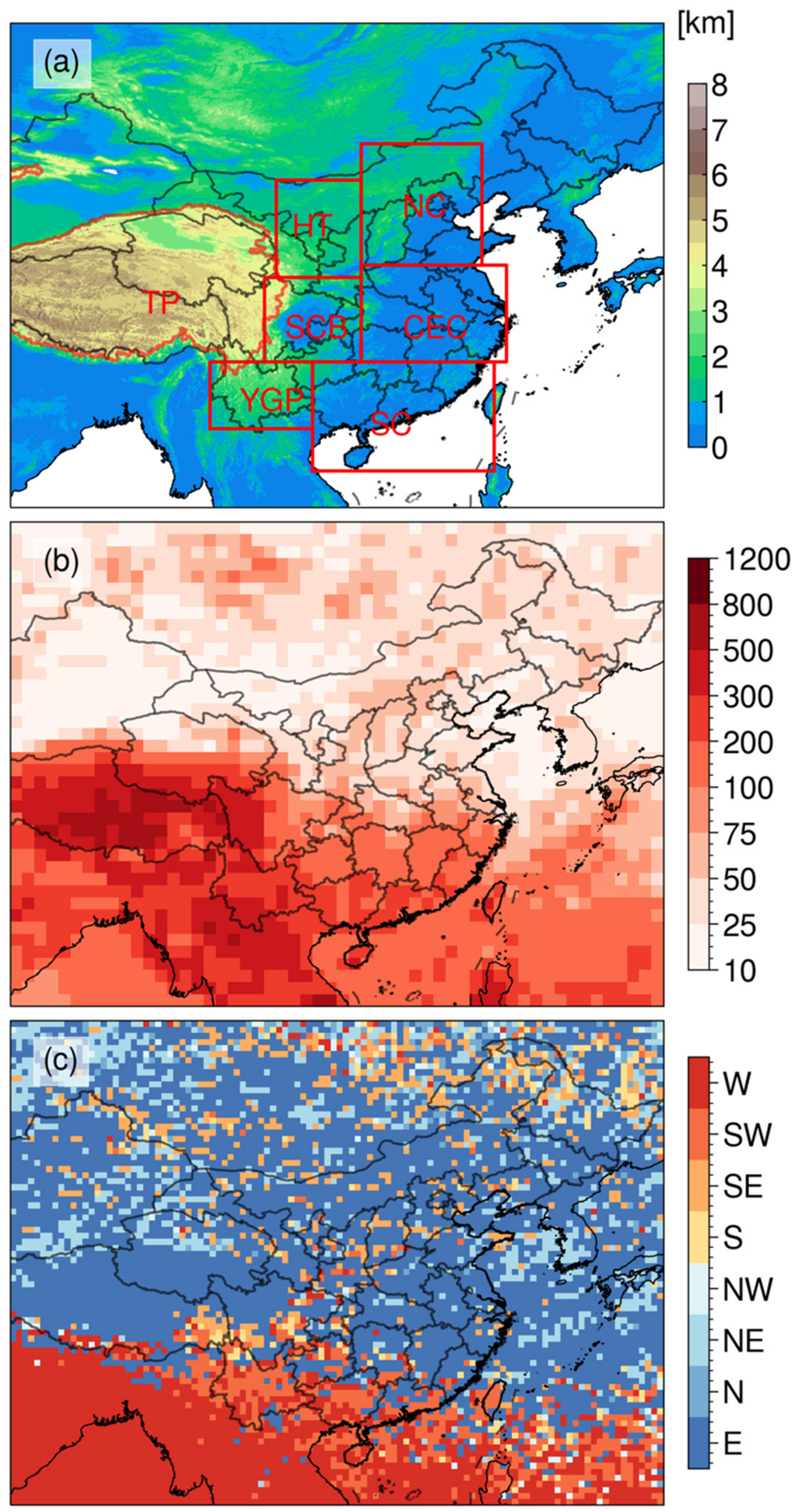
Figure 1. (a) China and its vicinity. The filled colors represent terrain height (units: m). The seven sub-regions marked in red rectangles and contours are: HT (Hetao), NC (North China), TP (Tibetan Plateau), SB (Sichuan Basin), CE (Central Eastern China), YP (Yunnan-Guizhou Plateau) and SC (South China) regions. See also in Table 1; (b) Mean spatial distribution of convective systems (numbers) on 1° × 1° grids; and (c) peak propagation direction for deep convective systems on 0.5° × 0.5° grids during warm seasons from 2016 to 2020. The peak propagation direction/mean spatial distribution at any grids is accessed from assigning the propagation direction/spatial distribution with the maximum/mean number of convective systems.
Remotesensing 13 04289 g001
Figure 2. Frequency and cumulative distribution function (CDF, blue solid line) of convective (a) lifetime, (b) propagation speed, (c) areas. The boxplot of (d) lifetime (e) propagation speed and (f) areas of convective systems over Hetao (HT), North China (NC), Sichuan Basin (SB), Central Eastern China (CE), Yunnan-Guizhou Plateau (YP), Tibetan Plateau (TP), South China (SC) and Ocean (OC), respectively. The white circle dot indicates the average value in (df).
Remotesensing 13 04289 g002
Figure 3. (a,b) Frequency distribution of convective cloud top vertical velocity (w) at different cloud top heights; (c,d) Frequency (grey bar) and cumulative distribution function (CDF) (blue line) of the cloud top vertical velocity at all levels. The panels are over land (left column) and ocean (right column), respectively.
Remotesensing 13 04289 g003
Figure 4. Density of the convective systems identified (number per 1 × 1 degree latitude) on 1° × 1° grids during (a) April (b) May (c) June (d) July (e) August and (f) September during 2016–2020.
Remotesensing 13 04289 g004
Figure 5. The heatmap of monthly and hourly variability of convective activities, (a,d) the histogram of hourly variability, (b,e) the month-hour heatmap, and (c,f) the histogram of monthly variability of the convective systems over land and ocean, respectively.
Remotesensing 13 04289 g005
Figure 6. Diurnal variation of occurrence frequencies of convective systems at its initiation, maximum maturity and dissipation stages over land and ocean.
Remotesensing 13 04289 g006
Figure 7. Same as Figure 4, but for deep convective systems initiation (DCSI).
Remotesensing 13 04289 g007
Figure 8. Monthly and hourly variability of DCSI occurrences over (a) Hetao (HT), (b) North China (NC), (c) Sichuan Basin (SB), (d) Central Eastern China (CE), (e) Tibetan Plateau (TP), (f) Yunnan-Guizhou Plateau (YP), (g) South China (SC) and (h) Oceans (OC). The legend land and ocean represent that the convective systems over land and ocean in South China, respectively. The legend all means that the all of convective systems in South China. MCIO stands for Monthly DCSI Occurrence.
Remotesensing 13 04289 g008
Figure 9. Scatter distribution of DCSI during daytime (red dot) and nighttime (blue dot) in (a) North China (NC) (b) Sichuan Basin (SB) (c) Central Eastern China (CE) (d) Tibetan Plateau (TP) (e) Yunnan-Guizhou Plateau (YP) (f) South China (SC), respectively. The grey shade indicates terrain height (units: m).
Remotesensing 13 04289 g009
Table 1. Definitions of the regions used in this study.
RegionCover RegionNumber of Tracked
Convective
HT (Hetao)34°–42°N, 103°–110°E214
NC (North China)35°–45°N, 110°–120°E722
SB (Sichuan Basin)27°–34°N, 102°–110°E783
CE (Central Eastern China)27°–35°N, 110°–122°E1164
TP (Tibetan Plateau)-9339
YP (Yunnan-Guizhou Plateau)21.5°–27°N, 97.5°–106°E1977
SC (South China)18°–27°N, 106°–121°E18,287
Publisher’s Note: MDPI stays neutral with regard to jurisdictional claims in published maps and institutional affiliations.