1. Introduction
Chinese industry and agriculture have developed rapidly since their reform and opening up. Industrial and agricultural sewage and domestic wastewater containing large quantities of nitrogen and phosphorus are discharged into rivers and lakes. Many lakes— such as Chaohu Lake [
1], Taihu Lake [
2], and Dianchi Lake [
3]—have undergone eutrophication and experience frequent cyanobacterial blooms that have degraded their ecological functions. Their ecology is seriously damaged, as is the safety of using that water for human drinking purposes and to develop fisheries [
4].
A cyanobacterial bloom refers to a natural ecological phenomenon in which enormous quantities of cyanobacteria are rapidly produced in freshwater bodies; it is a characteristic associated with the eutrophication of water bodies. After breeding, cyanobacteria come to the water surface under the action of airbags, causing green paint-like water-blooms [
5]. When cyanobacteria bloom, algae accumulate on the surface of the water body; thus, it is not suitable to measure limnological parameters such as chlorophyll a concentration, since water at different depths will exhibit varying concentrations. The difference between cyanobacterial blooms and other algal blooms is that the cyanobacteria gather on the surfaces of water bodies. Therefore, cyanobacterial blooms have similar spectral characteristics to those of vegetation (that is, predominantly high reflectance in near-infrared bands), which are obviously different from the low reflectivity of ordinary water bodies in the near-infrared bands. Thus, it could be more convenient to identify cyanobacterial blooms via remote-sensing images that can distinguish the high contrast associated with near infrared reflectance [
6]).
The traditional cyanobacterial bloom monitoring method is based on ships entering a lake for fixed-point sampling monitoring; however, this is spatiotemporally limiting. In addition, this process uses much human and material resources, which makes its use for cyanobacterial bloom monitoring difficult. The development of satellite remote-sensing technology has improved the resolution, obtainment of parameter information, and observation accuracy of remotely sensed data and images. Satellite remote sensing thus became the main method for obtaining cyanobacterial bloom information because, as an advanced method, its advantages included a wide monitoring range, fast speed, low cost, and ease of use for long-term dynamic monitoring. Satellite remote sensing can comprehensively detect cyanobacterial blooms in lakes and reservoirs. However, the monitoring of these blooms based on optical satellite remote sensing also has disadvantages, mainly related to its vulnerability to the influence of clouds. On cloudy days or in cloudy weather, effective data often cannot be obtained. In addition, cyanobacterial blooms change rapidly over time during a single day. Geostationary satellites are generally required to monitor changes in cyanobacterial blooms over time [
7]. However, the spatial resolution of geostationary satellite remote-sensing data is generally so low that it is impossible to use to monitor small lakes and reservoirs. Moreover, the spatial coverage of geostationary satellite remote-sensing data is limited, and there is no coverage in many regions. Unmanned aerial vehicles (UAVs) equipped with sensors can fly under clouds and conduct small-scale monitoring of cyanobacterial blooms using space-based remote-sensing methods [
8,
9]; however, these are expensive and difficult to use for long-term multifrequency monitoring.
Ground-based remote sensing has become an important supplement to cyanobacteria bloom monitoring to compensate for the limitations in water surface sampling and satellite and UAV remote remote sensing [
10,
11,
12,
13,
14]. The satellite image here is GF1-WFV and GF6-WFV, which is very close in time to the images acquired by ground-based spectrometers.
Ground-based remote sensing uses an observation platform arranged at a height (e.g., on a mountain or tower) on the bank of the water body to be monitored to allow regular remote-sensing-based monitoring of the water body. Ground-based remote-sensing can take images under cloud cover and is not affected by cloudy days or weather. It has the advantages of automation, stability, long-term persistence, and a high spatiotemporal resolution.
In this study, ground-based imaging remote-sensing technology was applied to monitor of cyanobacterial blooms in Dianchi Lake for the first time. The ground-based array multispectral camera processing system was mounted on a rotatable cloud platform at a fixed station on a mountain west of Dianchi Lake and used to obtain multitemporal, multidirectional, and multilandscape measurements of cyanobacterial blooms in the north of Dianchi Lake. First, the distribution of cyanobacterial blooms was extracted based on ground-based multispectral data. This data was then compared with those extracted from a synchronous satellite remote-sensing system. It was demonstrated that the ground-based remote-sensing data on of cyanobacterial blooms was highly accurate, thus showing that the band setting of the ground-based multispectral cameras was reasonable. Next, the diurnal variation in the distribution of the cyanobacterial bloom in Dianchi Lake was analyzed using ground-based remote-sensing images obtained every hour. Finally, the advantages and limitations of ground-based imaging multispectral remote-sensing data are discussed.
2. Materials and Methods
2.1. Overview of Dianchi Lake and the Site Selected for the Ground-Based Imaging Remote-Sensing Platform
Dianchi Lake is part of the Jinsha River water system in the Yangtze River Basin and is located in the southwest of Kunming City. It is a faulted structural freshwater lake, the on the Yunnan–Guizhou Plateau. It is at an altitude of 1886 m; has an area of 330 km
2, a shoreline with a total length of 163 km, an average water depth of 5 m, and a maximum depth of 10 m; and is 40 km long from north to south and 12.5 km wide from east to west. The rainy season is from May to October, with precipitation occurring during approximately 85% of the entire year. There is much cloud cover during the rainy season, and the effective image acquisition rate of multispectral satellite remote-sensing data is low. Landsat 7 ([
15], MODIS [
16], GF1-WFV [
17], and HJ-1CCD [
18] satellite remote-sensing images were used -o obtain the normalized difference vegetation index (NDVI) [
19] and floating algae index (FAI) [
3] from which data on cyanobacterial blooms were extracted and spatiotemporal distribution laws thereof for Dianchi Lake explored; these generally show distribution characteristics based on “emphasizing the north and neglecting the south” [
20].
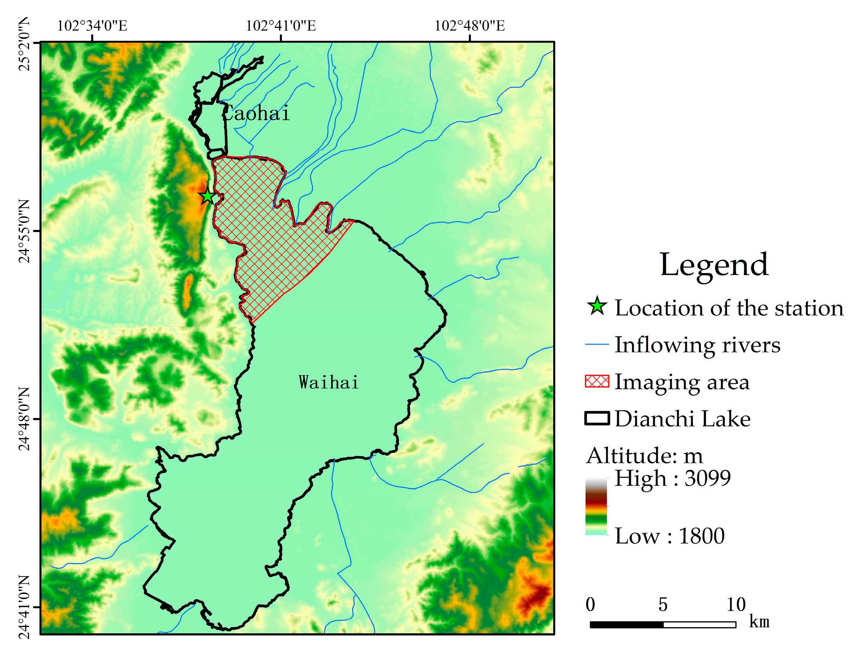
Mount Xi is 15 km into the western suburbs of Kunming City, and is part of a range consisting of the Huating, Taihua, and Luohan mountains. This area includes more than 40 km of mountains with altitudes of approximately 2500 m; the nearest horizontal distance from Dianchi Lake is 700 m. It is the best location for a ground-based imaging remote-sensing platform to observe Dianchi Lake. Therefore, a building in the western part of these mountains was selected as the foundation for a remote-sensing observation platform (the five-pointed star in
Figure 1); it was built at an altitude of 2461 m and had an altitude difference of approximately 575 m from Dianchi Lake.
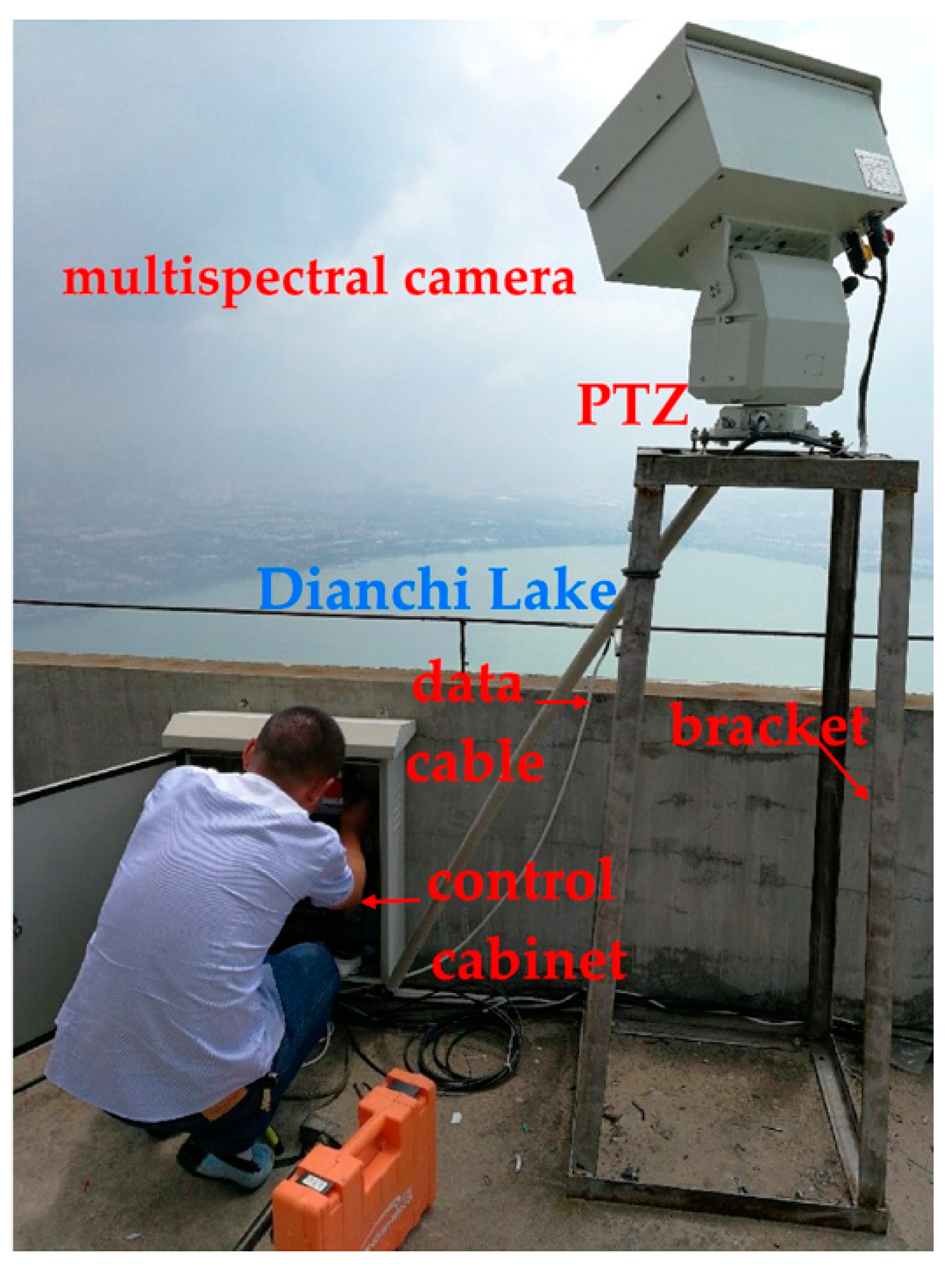
A rotating pan–tilt–zoom (PTZ) was installed on a metal fixed support installed on an observation platform. A multispectral camera was erected on the PTZ and used to observe Dianchi Lake. The Caohai was seen to the north. Considering that blue–green algae blooms break out mainly in the Waihai, the actual effective boundary of the northern observations is the Hubin West Road, which is the boundary between the Caohai and the Waihai. The water surface 8 km from the Hubin West Road can be observed to the south of the platform, and the included angle between the line connected to the water surface and the vertical line from the platform to the south (the observation zenith angle) is 85.9°. The included angle between the platform and the nearest horizontal plane and the vertical line is 50.6°. The actual effective observation range of the multispectral camera on the platform is shown in the purple area of
Figure 1; it is an area of approximately 41.5 km
2, and includes just the areas where cyanobacterial blooms occur most frequently.
2.2. Introduction and Operation Method of Ground-Based Imaging Remote-Sensing System
The ground-based imaging multispectral remote-sensing system includes a special high-definition multispectral camera (MSPCam) to monitor cyanobacterial blooms, PTZ (pan–tilt–zoom), and special support accessories (including adaptive configuration and corresponding installations, a power supply, environmental protection accessories, and a data transmission interface) (
Figure 2). The ground-based MSPCam was customized by the Xi’an Institute of Optics and Mechanics, Chinese Academy of Sciences. It uses four multispectral detection channels; the central wavelengths were 562 nm, 622 nm, 661 nm, and 751 nm; and the spectral bandwidths were 17 nm, 13 nm, 16 nm, and 15 nm. The ground-based imaging multispectral remote-sensing system receives the instruction setting (uplink) through a wired network for automatic continuous multispectral image acquisition and transmits the image data to the computer through the wired network (downlink). The shooting interval was 0.5 h. The pan/tilt was rotated every 0.5 h, and seven images were taken in sequence for subsequent mosaicking into a complete image.
2.3. Preprocessing Ground-Based Remote-Sensing Images
Ground-based remote-sensing image preprocessing includes the following five aspects and specific processing steps.
- (1)
The MSPCam system was geometrically calibrated to obtain the internal and external orientation elements of the multispectral camera. Simultaneous interpretation of band data obtained by different sensors is conducted by integrating azimuth elements, sensor parameters (e.g., probe size, focal length, field angle), and geometric imaging parameters (e.g., imaging distance, pitch angle).
- (2)
An oblique imaging image is converted into an orthophoto image based on both its sensor parameters and geometric imaging parameters.
- (3)
Spatial spectral information (spatial variable convolution kernel based on spectra) is used comprehensively to denoise the data and maintain the difference between individuals (pixels) in the plot. Adaptive clarity processing is then carried out.
- (4)
Multiangle images are spliced according to the sensor and geometric parameters of different angle images (e.g., imaging distance, azimuth, pitch angle).
- (5)
The water mask is extracted using normalized difference water index (NDWI) threshold segmentation. NDWI will consider places affected by cyanobacterial blooms as land. The water mask can, at this point, be extracted using a local manual check.
2.4. Extracting Cyanobacterial Bloom Data from Ground-Based Multispectral Images
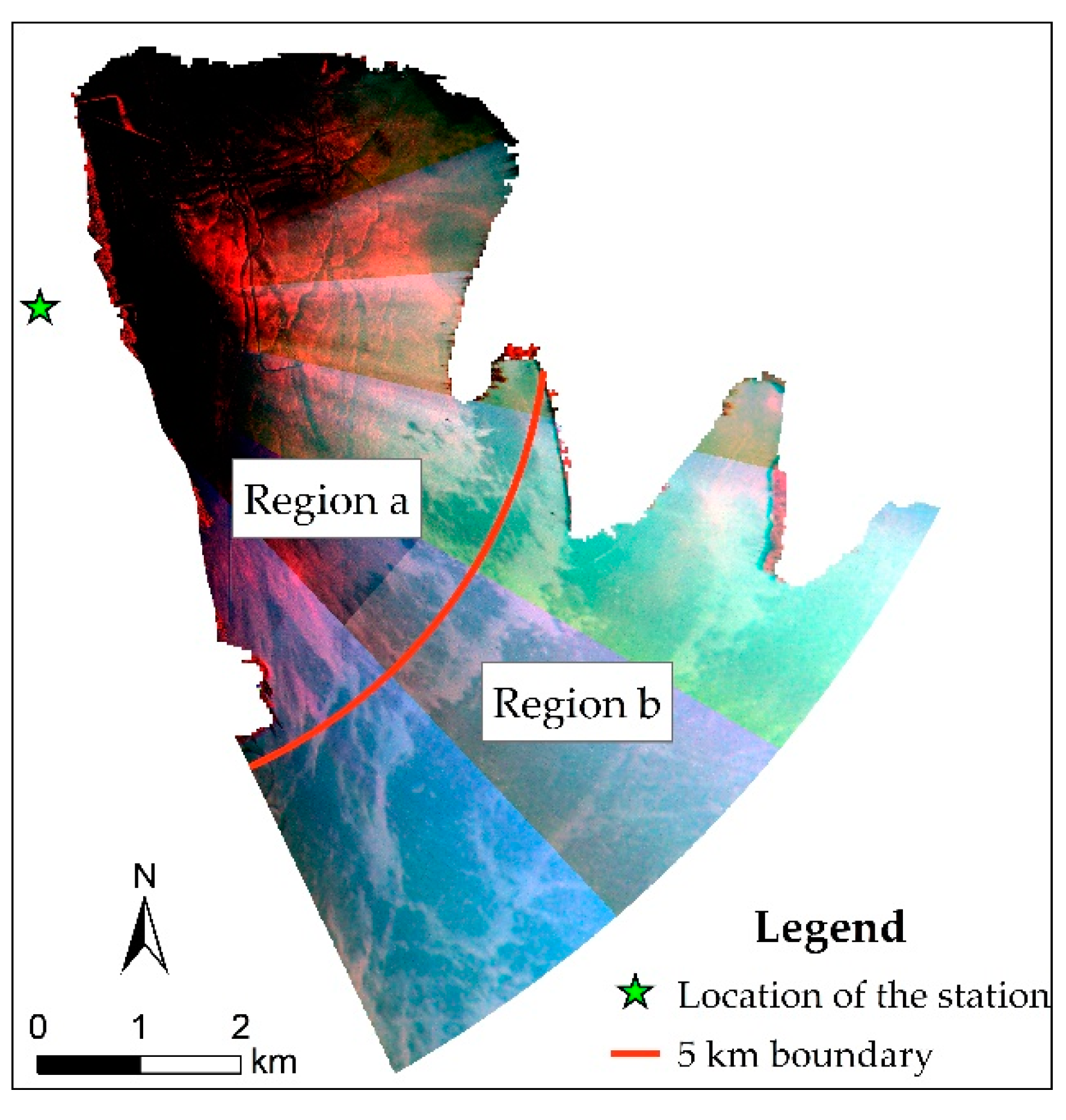
The spectral characteristics of cyanobacterial blooms are markedly different from those of the normal water body; for example, the reflectivity of cyanobacterial blooms is significantly increased in the near-infrared spectrum. A cyanobacterial bloom is shown in red in the false-color image in
Figure 3.
Therefore, the NDVI threshold segmentation method can be used to monitor cyanobacterial blooms. NDVI is defined as the normalized ratio of the red-light band to the near-infrared band as follows:
The observation angle difference of ground-based multispectral remote-sensing images is usually very high, from 50.6° to nearly 85.9°. When this happens, the specular reflectance of the sky light on the water surface is also relatively high; therefore, the latter is also greatly affected by the specular reflection of the sky light on the water surface, which in turn is affected by the solar orientation, the distribution of the sky light, and the distribution of the clouds when there is cloud cover. Therefore, it is very difficult to correct the reflection of the sky light on the water surface and it is also difficult to use a unified NDVI threshold to extract cyanobacterial blooms without correcting for this reflection. However, because the reflection of sky light on the water surface is mainly determined by the observation angle, ground-based multispectral camera images can be divided into two areas based on the observation angle. Different NDVI thresholds can be determined for each area, based on the visual interpretation effect, and cyanobacterial blooms can be identified.
We used a standard false-color composite (R: near infrared band; G: red band; B: green band) image to perform visual interpretation, where the red color in the lake is the cyanobacteria bloom. We constantly adjusted the NDVI threshold to extract cyanobacterial blooms, until the cyanobacterial bloom results best matched the red area in the standard false-color composite image.
ENVI 5.3 was used to process the ground-based multispectral images as follows. (1) The NDVI tool was used to calculate NDVI using the 661 nm and 751 nm bands. (2) The ROI tool was used to draw regions of interests, Region a and Region b. (3) The build mask tool was used to extract blooms through the segmentation of NDVI with appropriate thresholds determined by visual interpretation of the false-color composite images.
4. Discussion
4.1. Advantages of Ground-Based Imaging Remote Sensing for Monitoring Cyanobacterial Blooms
Owing to the influence of cloud cover and the annual coverage available for GF1-WFV and GF6-WFV for the period 2014 to 2020, the cloud-free effective data for Dianchi Lake were found mainly in 35–55 scenes and there is little other effective satellite data. However, the ground-based imaging remote-sensing data can produce multiscene data every day, and shooting time can be set according to demand. The ground-based imaging remote-sensing data can also better compensate for the shortcomings of multispectral satellite data that are limited by weather conditions and are generally less effective. Moreover, ground-based remote sensing also makes it possible to monitor daily changes in cyanobacterial blooms and accurately reflect their spatiotemporal distribution characteristics, which can provide more timely and accurate information for salvage treatments and early warnings of cyanobacterial blooms.
4.2. Prospects for Using Ground-Based Remote Sensing to Monitor Cyanobacterial Blooms
The layout of ground-based imaging remote sensing is greatly affected by terrain, as it generally requires high mountains or towers to be present next to the target water body. At the same time, the ground-based remote sensing camera must be placed at a location not too far from the surface of the water, otherwise the observation angle will be too high, pixel resolution too low, and the sky light reflection will have a greater influence. The observation angle of ground-based imaging remote sensing is generally high, and these are greatly affected by reflections from the sky light and water surface. This study has not developed a method to correct for sky light water-surface reflection and water leaving reflectance, which is currently difficult but could be a future breakthrough. If the corrections for the sky light water-surface reflection can be made for the entire distribution map, a unified cyanobacterial bloom segmentation threshold can be developed for the same. This would allow attempts to create a method to automatically determine the threshold needed to automatic extract the cyanobacterial bloom data.
The multispectral camera can be mounted on a tower next to or in a lake. The height and location of the tower should be designed according to the intended observation area. To minimize the effect of sky light reflection, the observation angle should be within 60°, and the maximum angle should not exceed 80°. According to the observation angle, the height of the location of the tower can be approximately calculated based on trigonometric functions.
5. Conclusions
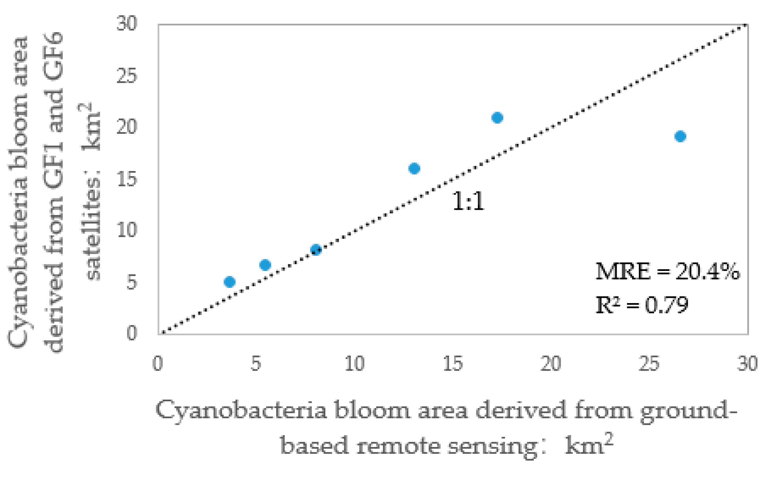
The demand for cyanobacterial bloom monitoring and early warnings from Dianchi Lake are seriously affected by the high cloud cover over the latter and the low effective acquisition rate of satellite remote-sensing data. In contrast to this, ground-based remote sensing can take images under cloud cover and provides a new technical method for dynamically monitoring of cyanobacterial blooms. In this study, a ground-based remote-sensing platform set up on a mountain west of and next to Dianchi Lake was used to conduct a preliminary study of its use in monitoring cyanobacterial blooms. First, the distribution of cyanobacterial blooms was extracted based on ground-based multispectral images; these were then compared with the extracted results from synchronous satellite remote-sensing images. The squared correlation coefficient (R2) and the average relative error for these results were found to be 0.79 and 20.4%, respectively. This showed that the cyanobacterial bloom data extracted using ground-based remote sensing was highly accurate. Following this, the daily variation in the distribution of cyanobacterial bloom in Dianchi Lake was analyzed using ground-based remote-sensing images obtained daily, and it was found that the daily variation of the area of the cyanobacterial bloom ranged from 56.8%–545.9%, indicating that ground-based imaging remote sensing can accurately reflect the spatiotemporal distribution characteristics of cyanobacterial blooms. It can thus be used to provide timely and accurate information for salvage treatment and early warnings of the latter. Finally, the difficulty of using ground-based remote sensing to monitor cyanobacterial blooms came from the need to correct for reflectance from the water surface sky light and the surface of the water and the automatic extraction of the distribution of cyanobacterial bloom data based on this; these have been noted as a problem to be solved in the future. In short, the dynamic monitoring of cyanobacteria blooms can be operationalized using ground-based remote-sensing data. The methods used in and results from this study can also provide a reference for monitoring cyanobacterial blooms in other lakes.


