1. Introduction
Water vapour, accounting for only roughly 0.25% of the mass of the atmosphere, is a highly variable constituent [
1]. Large spatial and temporal variations characterize both its global and regional distribution, making its observation at suitable resolutions a demanding task. At the same time, it denotes the most important greenhouse gas impacting global warming, a key component of the hydrological cycle and the basic prerequisite for all forms of precipitation. Thus, observations of atmospheric water vapour are of key importance for weather forecasting and climate studies. Therefore, a multitude of observation systems were developed, but all of them are subject to systematic errors and usability constraints in different environmental conditions. Utilized sensors range from classical radiosonde measurements to ground-based microwave radiometers and modern satellite missions specifically designed for the retrieval of water vapour.
Global Navigation Satellite Systems (GNSS) belong to the latter category, although they were originally built up for different purposes. In addition to their typical applications, such as positioning and navigation, GNSS have become a feasible alternative for remote sensing of the troposphere over the last decades, in particular for atmospheric water vapour. The derivation of the atmospheric water vapour content from GNSS is based on the fact that GNSS signals transmitted between the satellites and the ground-based receivers are affected by the atmosphere [
2].
This fact has given rise to the scientific field of GNSS Meteorology, whose basic concept was outlined by Bevis et al. [
3]. The GNSS signal experiences a delay, which depends on the amount of water vapour contained in the atmosphere along the signal path. This delay is typically estimated for the zenith direction and, therefore, called the Zenith Total Delay (ZTD).
The ZTD is related to the weather conditions in the vicinity of the GNSS station (pressure, temperature, and humidity) and, therefore, carries valuable meteorological information [
4], which can be exploited by means of data assimilation (DA) in numerical weather prediction (NWP). Unfortunately, the ZTD denotes an integral measurement along the vertical and, therefore, does not provide a suitable vertical resolution that can be easily mapped to meteorological conditions in various height layers.
For beneficial usage in NWP, high accuracy requirements (∼1 cm [
5]) have to be met for ZTD estimates. Therefore, typically double-difference (DD) processing of static reference station networks is applied in GNSS analysis. Nevertheless, using alternative approaches, such as Precise Point Positioning (PPP) for GNSS Meteorology have been investigated over the recent years (e.g., [
5,
6,
7,
8]), due to the manifold benefits of the technique. These include independence of reference station data and, therefore, smaller data amounts for processing, reducing latency time of resulting products, which is crucial in particular for near-real time NWP operation (Nowcasting).
However, most studies and operational products still use only dual-frequency (DF) observations from fixed stations, due to the easier data processing and more controllable environmental conditions. Thus, SF-PPP processing for troposphere monitoring has yet been explored by only a limited number of studies (e.g., [
9,
10,
11]). Deng et al. [
12] densified an already existing station network with SF receivers and retrieved tropospheric delays using static PPP in post-processing mode.
In order to deal with the ionospheric influence, they developed the Satellite-specific Epoch-differenced Ionospheric Delay (SEID) model, which uses information from the surrounding reference stations to generate synthetic observations on a second frequency for the SF receiver. This approach was also investigated in the course of this study for kinematic observations. Krietemeyer et al. [
10] studied the feasibility of using low-cost receivers to increase the density of GNSS networks for retrieval of the Precipitable Water Vapour (PWV).
They processed one year of GNSS data from an IGS station and two co-located SF stations by using the SEID algorithm to correct for the ionospheric influence. Mendez Astudillo et al. [
13] carried out a performance assessment of three PPP online services and three software packages concerning ZTD estimation. In this context, they compared ZTD estimates from PPP processing to those obtained from the IGS tropospheric products.
The results indicate that the online PPP service performance was better than those of selected PPP software packages in all cases. Zhao et al. [
14] estimated both PWV from low-cost multi-GNSS receivers in static mode. They retrieved ZTDs with an accuracy better than 10 mm compared with tropospheric products published by IGS and about 3 mm for PWV compared to radiosonde results.
The possibility of monitoring tropospheric parameters from kinematic platforms has been investigated by only a small number of studies. Most of them concentrated on maritime environments, such as ship-borne [
15,
16,
17,
18] and buoy data [
19,
20]. ZTD estimation from airborne data was initially investigated by Skone et al. [
21].
Up until now, the only investigation on train-borne GNSS data was carried out by Webb et al. [
22], who analysed Zenith Wet Delay (ZWD) for over a decade of continuous DF observations over a range of altitudes on the Snowdon Mountain Railway, located in Snowdonia National Park, North Wales. Their multi-system GNSS solutions yielded an improvement of about 5 mm in ZWD estimated in kinematic PPP mode, compared to the GPS-only solution. The overall agreement in ZWD with NWP-based reference data was 11.6 mm for the multi-GNSS solution and 16.2 mm for the GPS-only solution.
Our present study goes beyond the investigations outlined above by applying kinematic PPP processing on SF-GNSS data gathered by receivers, which are mounted on trains. The study, therefore, represents an initial assessment of the usability of train-borne SF-GNSS data for meteorological purposes and the challenges associated with this approach. The underlying idea is to use trains travelling on rail-tracks in the federal reserve of Austria as permanently moving meteorological sensors. Currently, a large number of trains (∼1400) are equipped with dual-system SF receivers, which are currently able to track GPS and GLONASS signals. Data is gathered on different railway tracks over Austria in the course of the project Greenlight, led by ÖBB.
The main motivation of using train-borne data for GNSS Meteorology is the much denser spatial resolution due to the large number of sensors that are possibly available. These travel through different height regions and weather systems and, therefore, are predestined to investigate small-scale phenomena that are currently hard to represent in NWP [
23]. On the other hand, a significantly higher number of challenges is experienced due to the specific nature of the data set.
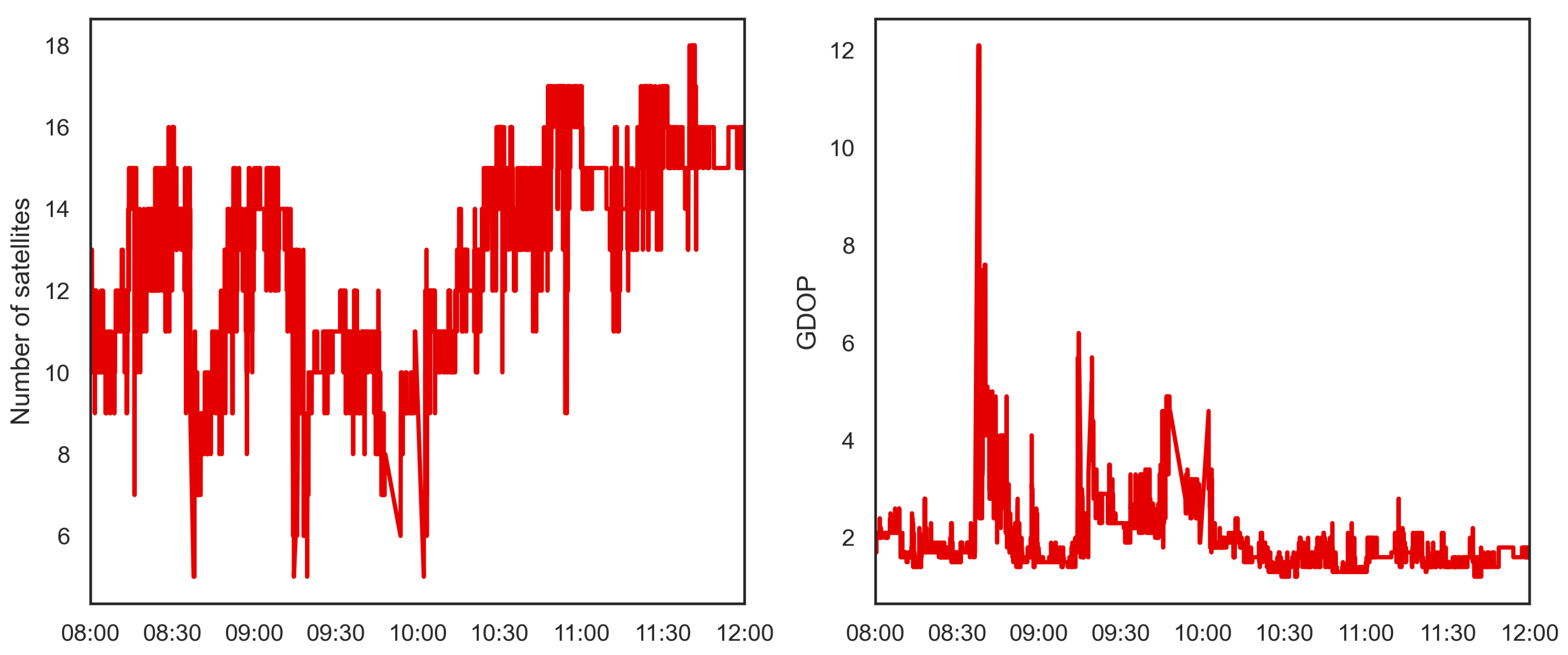
This concerns problems, such as high kinematics (travel speeds of over 200 km/h), ionospheric mitigation (SF data) and a large variety of critical environments encountered along the tracks. Nevertheless, first investigations have already shown the feasibility of this specific dataset for tropospheric monitoring [
24]. This study aims to establish some of the basic knowledge on data processing and estimation of tropospheric parameters from highly-kinematic sensors with sufficient accuracy.
The results shown here concentrate on ZTD estimation and validation using independent, NWP-based reference data as well as first tests of assimilation into an NWP model. Further case studies and detailed analysis concerning other aspects and results of the PPP processing of these data sets can be found in Aichinger-Rosenberger [
25].
4. Discussion and Conclusions
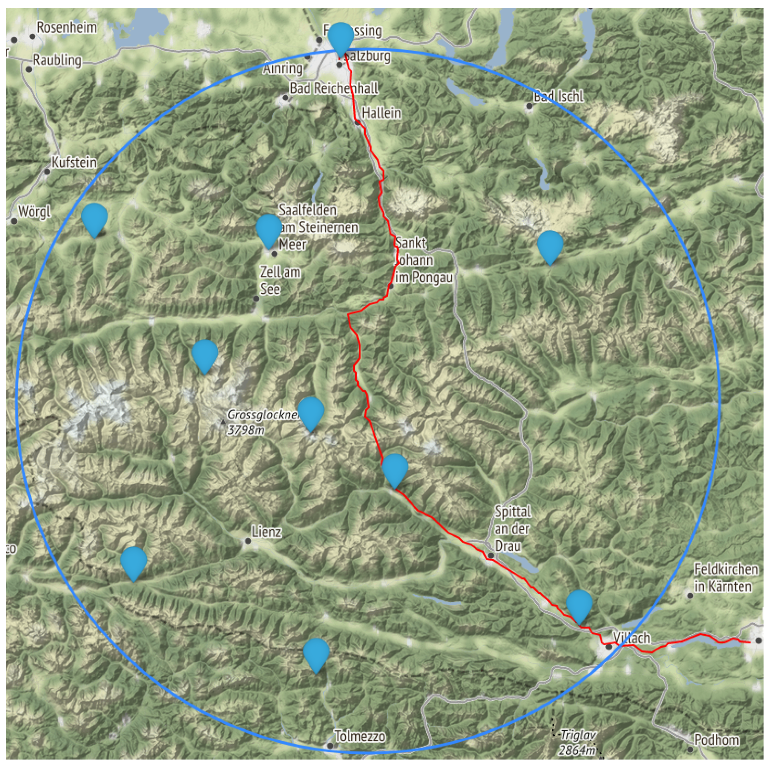
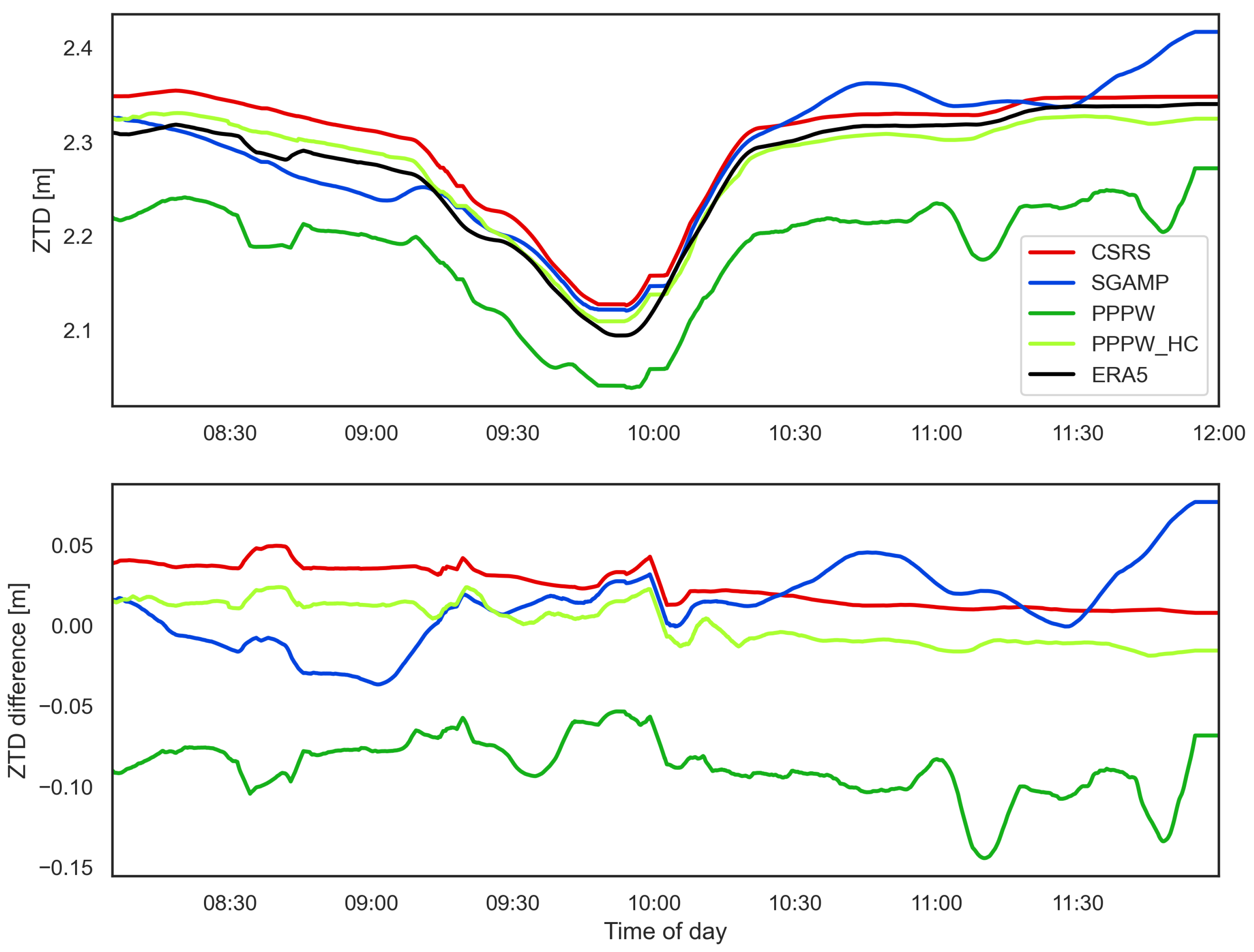
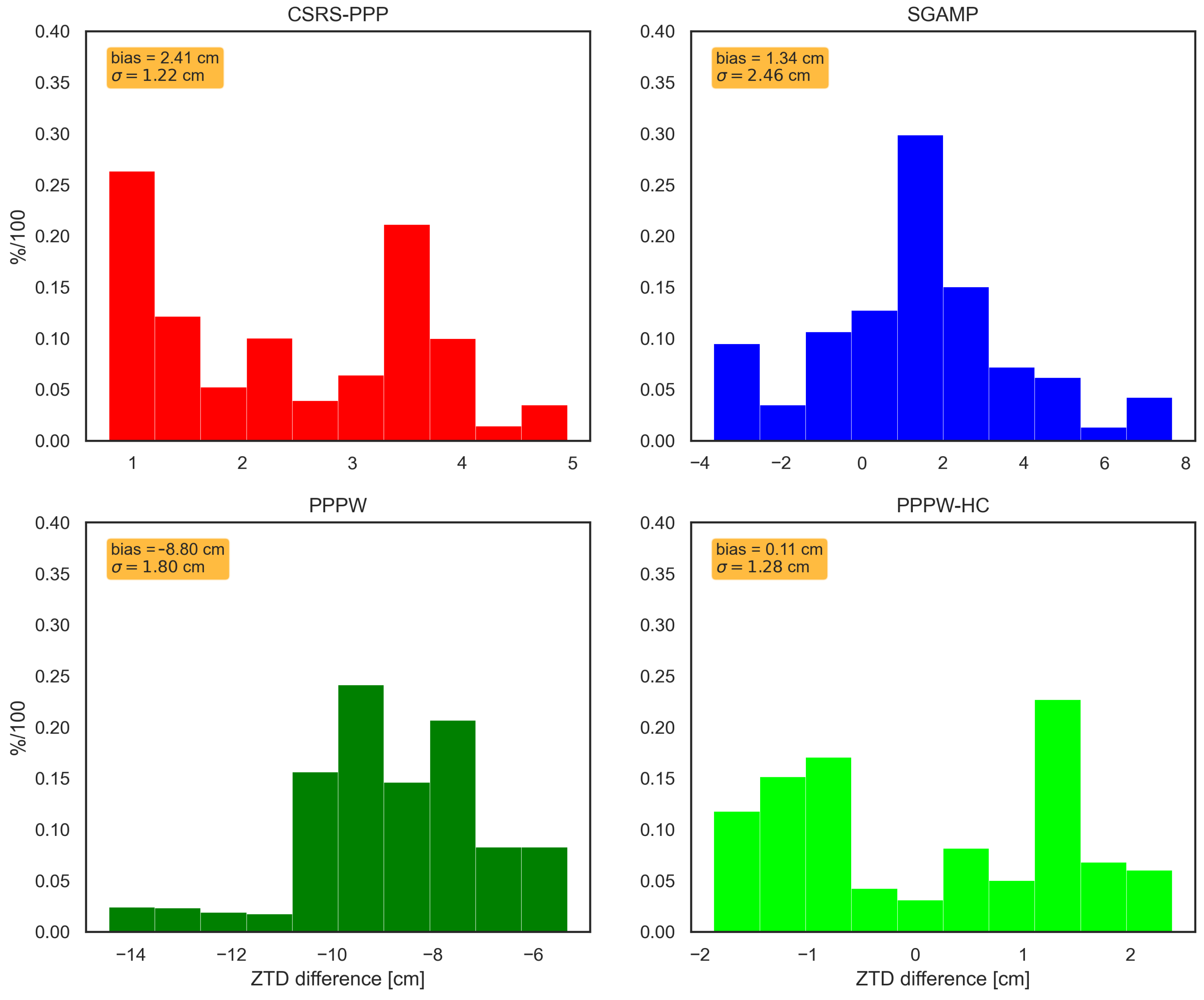
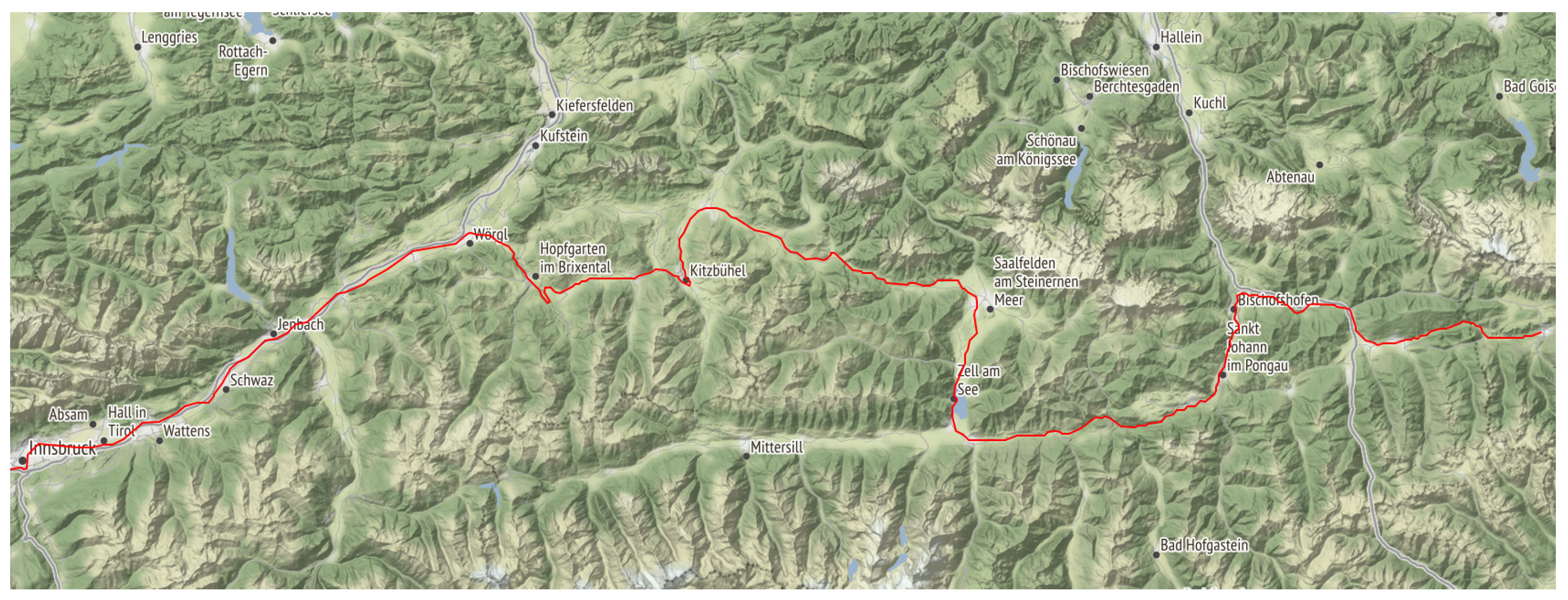
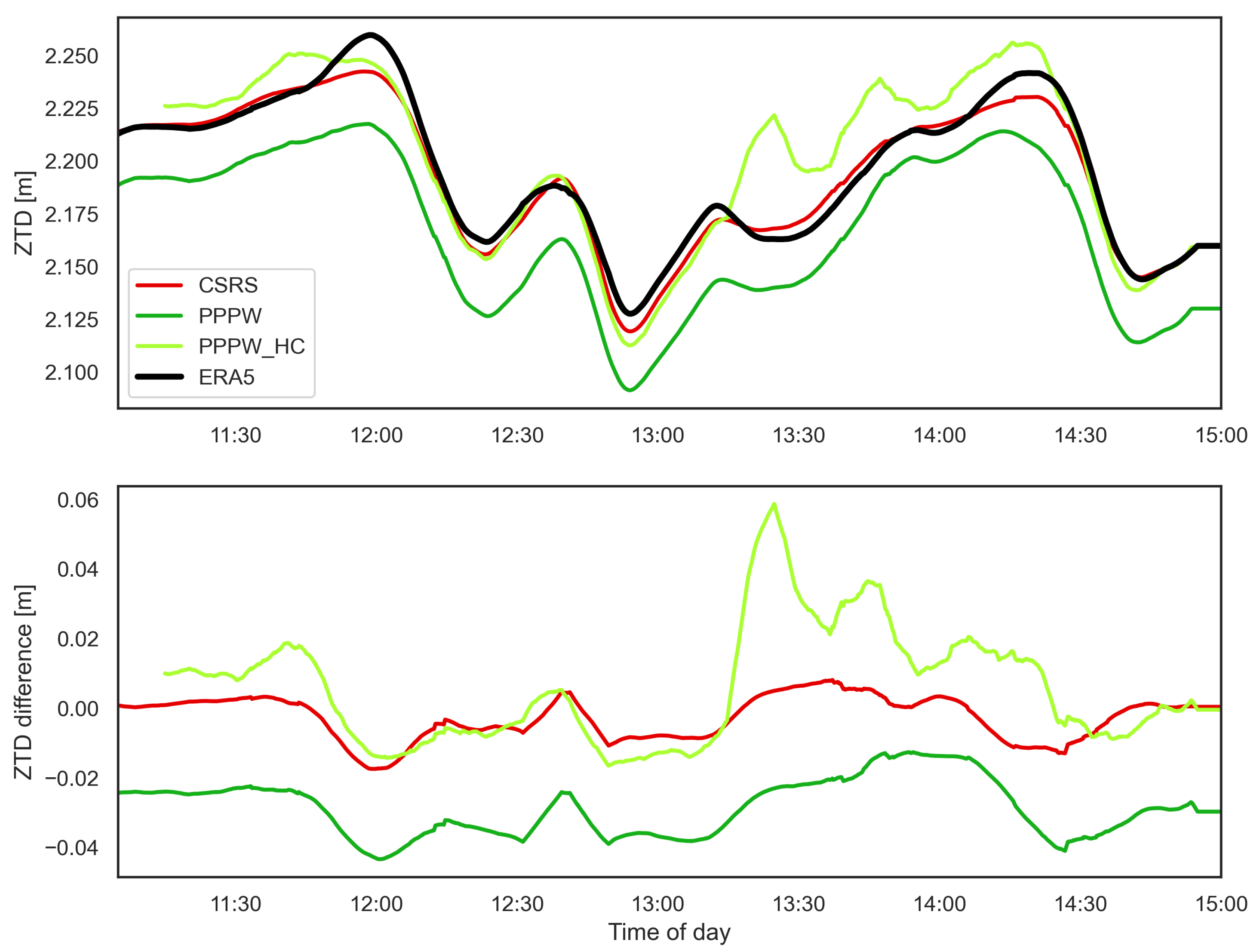
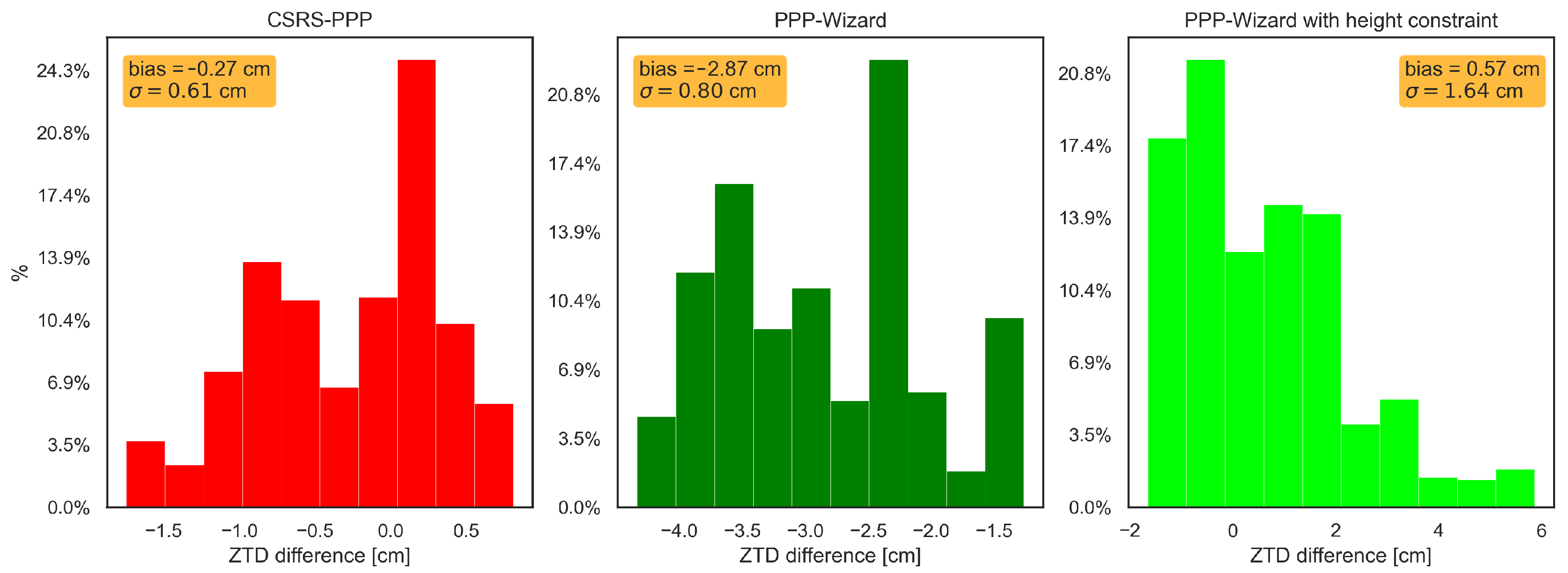
This study assessed the feasibility of deriving tropospheric parameters from GNSS receivers operated on trains and their usability for assimilation in NWP models. GNSS-ZTD estimates were produced by kinematic PPP processing using four different processing schemes based on different software packages (CSRS-PPP, SGAMP, PPPW, and PPPW-HC). The derived GNSS-ZTD estimates were validated using reference ZTD computed using ERA5-reanalysis data (ERA-ZTD) for two test cases (specific days and train travelling routes).
Although the initial results indicated a good overall agreement between GNSS-ZTD and ERA-ZTD, significant differences between processing schemes and test cases were visible. On average, the GNSS-ZTD solutions agreed at the low cm to mm level with ERA-ZTD. No distinctive superiority of one processing scheme over the others was recognized, although certain strengths and weaknesses of different schemes were visible.
As an alternative approach of ionospheric mitigation for SF data, the SEID model was modified to a kinematic mode and tested for CS1. The corresponding processing scheme (SGAMP) showed promising results, especially for highly challenging applications, such as presented here. SGAMP had a significantly lower bias (1.34 cm) compared to CSRS-PPP/PPPW (2.4/8.8 cm), and the correlation with ERA-ZTD was as high as for the other solutions. This makes the SGAMP processing scheme a promising candidate for future investigations on this topic, although further experience and tests are definitely required.
Furthermore, the performance of GNSS-ZTD estimation can be improved by applying a state constraint on the height coordinate in parameter estimation. With the aid of height coordinates of the investigated railway tracks, stored in the official track database of ÖBB, the Kalman filter module of the PPPW software was extended for such a height-constraint option. Solutions derived using this implementation showed medium to large improvements compared to the standard PPPW version and the other solutions. Overall, this provided the most accurate validation results for CS1 (bias ∼1 mm) and reasonable performance for CS2, although some problems were still found for certain periods.
In addition to the validation, the first assimilation tests for GNSS-ZTD data derived from trains were conducted for the presented test cases using the WRF model. A 4D-Var data assimilation scheme (WRFDA) was used for the assimilation of one hour GNSS-ZTD using a temporal resolution of one minute, i.e., 60 observations each case. Overall, the tests showed very promising results; however, (as for the validation results) distinctive differences between the test cases and processing schemes were evident. This is outlined by the comparison between both test cases.
For test case CS2, almost all GNSS-ZTD observations (CSRS-PPP: 100%, PPPW: 81%) passed the quality check of the WRFDA module, which performs the assimilation procedure within the WRF. On the other hand, the results for test case CS1 were significantly worse, as for most of the four tested processing schemes, not even half of the observations were accepted.
These differences most likely stem from the highly variable complexity of the environmental conditions (mountainous terrain and GNSS-denied areas, such as tunnels and urban areas), which might degrade both the NWP and GNSS performance. The major part of the experienced degradation for CS1 might be linked to the rather coarse representation of the topography in WRF (at 3 km in high mountainous regions) introducing the observed biases. This would also explain the local differences in the acceptance rate of GNSS-ZTD observations between the processed solutions.
For three out of four schemes (CSRS-PPP, PPPW-HC, and SGAMP) only observations in the first part of the investigated track were assimilated and, for PPPW, only observations from the end of the track. GNSS-specific error sources (e.g., multipath) will also still influence the results, but rather show in an increase of noise in the solutions, which has already been reduced by the moving-average filtering carried out in post-processing of the PPP solutions.
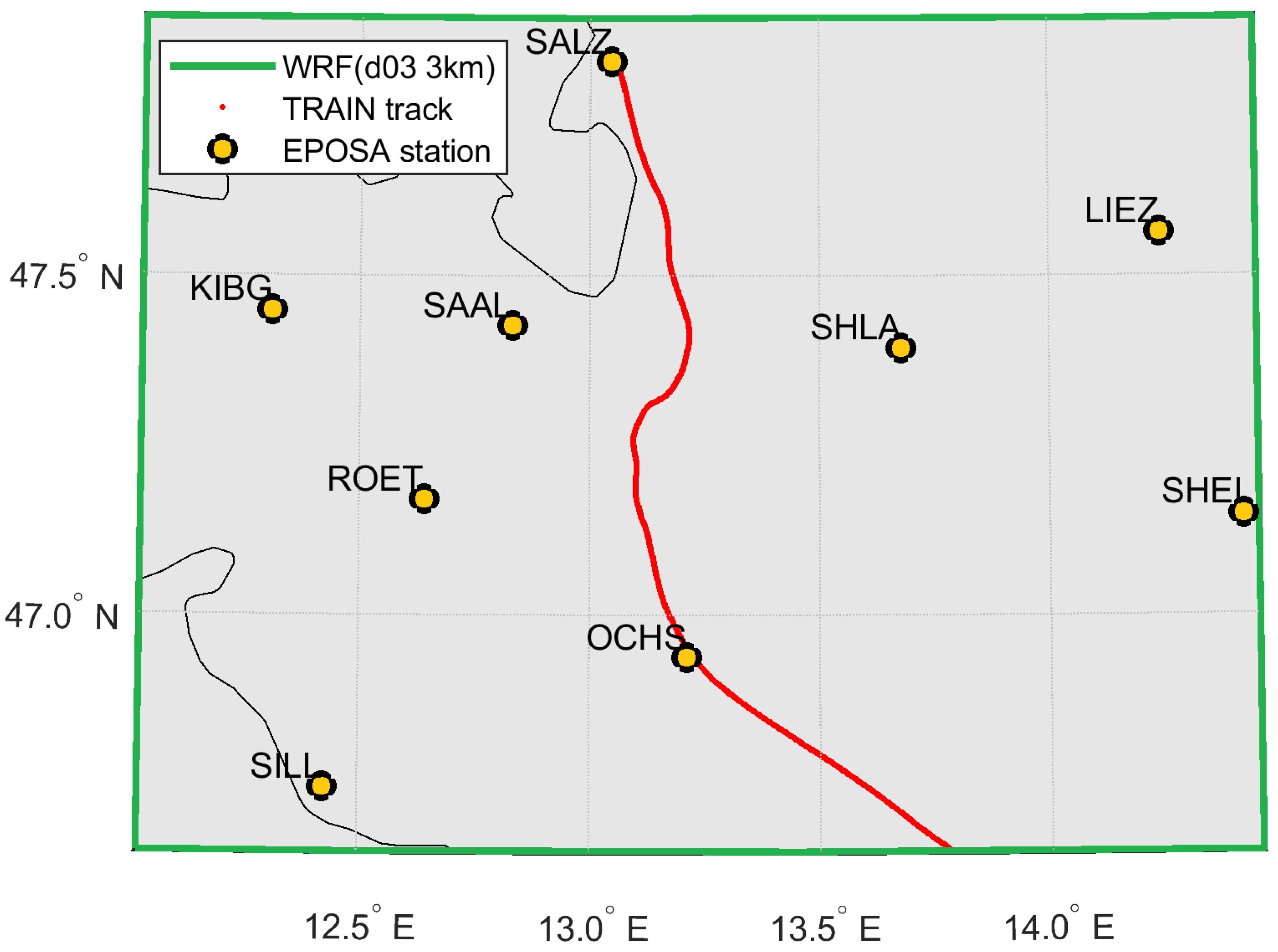
Furthermore, comparisons to independent GNSS-ZTD from geodetic reference stations were carried out for an initial assessment of the impact of train-borne ZTD on the WRF model state. The comparisons revealed differences from the mm range to 1–3 cm with respect to the independent ZTD estimates depending on the test case and processing scheme. These results indicate that further improvements in terms of quality of train-borne GNSS-ZTD are needed and to be tackled for in future studies.
However, the observed deviations (and even increases in bias) compared to the original model state were relatively small in most cases (few mm—1 cm) and could also be attached to other factors of uncertainty still present in this comparison, such as:
Bias correction: Typically, a bias correction is applied to all GNSS-ZTD estimates from static stations used in NWP data assimilation. This is done to correct for inconsistencies between model and real-world topography, which could lead to errors in the mm to cm range, especially in mountainous areas. For static data, different approaches, including static or variational techniques, have been developed. However, no typical procedure exists for kinematic data up until now, and even simple averaging over a number of collected time series along the same track was not possible in this study due to the limited data resources.
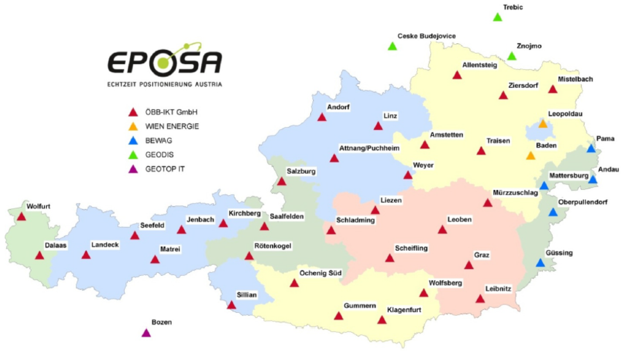
Formal errors of EPOSA-ZTD: Smaller deviations (in the mm range) between results with/without ZTD assimilation are often covered by the formal errors of the EPOSA-ZTD estimates.
Therefore, no solid conclusion on the impact of assimilating train-borne GNSS can be given for the present study. Moreover, as this investigation did not include the production of an actual (precipitation) forecast, it can only serve as a first indication of the usability of the GNSS-ZTD estimates in NWP. Therefore, the actual benefit of such data sets on a NWP forecast cannot yet be determined through verification of forecast products.
Overall, the presented study shows that reasonable ZTD estimates can be derived from train-borne SF-GNSS data. Although specific (pre-) processing has to be applied and the results are very sensitive to the chosen PPP setup, they are able to reach the desired quality for NWP applications. Although their actual impact on NWP forecasts is still uncertain and, therefore, a major topic for subsequent studies, chances for beneficial usage are high as data quality is expected to increase further with the planned installation of new-generation, low-cost (but DF) equipment on train fleets and more sophisticated processing approaches.
The initial idea of having a large fleet of trains (up to 1000 vehicles) and using each one of them as a meteorological sensor for atmospheric water vapour is expected to draw interest in the atmospheric science and NWP community, since the achievable horizontal and temporal resolution cannot be provided by any other sensor at the moment. Furthermore, a possible extension to near real-time ZTD estimation will be of great benefit for operational weather forecasting, particularly nowcasting applications.
