Article

Review of Collision Avoidance and Path Planning Methods for Ships Utilizing Radar Remote Sensing

by
Agnieszka Lazarowska
Department of Ship Automation, Gdynia Maritime University, 81-87 Morska St., 81-225 Gdynia, Poland
Remote Sens. 2021, 13(16), 3265; https://doi.org/10.3390/rs13163265
Submission received: 5 July 2021 / Revised: 13 August 2021 / Accepted: 16 August 2021 / Published: 18 August 2021

Abstract

:
The paper presents a comparative analysis of recent collision avoidance and real-time path planning algorithms for ships. Compared methods utilize radar remote sensing for target ships detection. Different recently introduced approaches are briefly described and compared. An emphasis is put on input data reception using a radar as a remote sensing device applied in order to detect moving obstacles such as encountered ships. The most promising methods are highlighted and their advantages and limitations are discussed. Concluding remarks include proposals of further research directions in the development of collision avoidance methods utilizing radar remote sensing.

1. Introduction

In the last decade, a dynamic growth of interest in the development of autonomous vehicles can be observed both in academia and industry. That interest can also be noticed in relation to unmanned and fully autonomous ships. Due to that reason the International Maritime Organization (IMO) introduced a new term that should be used when referring to autonomous vessels, IMO states that these kind of ships should be called Maritime Autonomous Surface Ships (MASS). IMO and different classification societies categorize ships according to their autonomy levels. According to IMO four degrees of autonomy can be distinguished. These are: a ship with automated processes and decision support, remotely controlled ship with seafarers on board, remotely controlled ship without seafarers on board and fully autonomous ship [1]. On a fully autonomous ship the operating system makes decisions and determine actions by itself.
An autonomous ship can be defined as a marine craft, equipped with sensors used to obtain information about the environment, that is characterized by automated navigation, propulsion and auxiliary systems and applies advanced control algorithms to operate without human intervention.
As it can be stated based upon the above mentioned description of an autonomous vessel, an important component of such vehicle is the Autonomous Navigation System (ANS). The aim of this system is to navigate the ship in order to follow the predefined route and adapting it taking into account encountered ships and weather forecasts. It is composed of Route Planning (RP) and Collision Avoidance (CA) modules. A subsystem providing input data to the ANS is the Advanced Sensor module (AS), also called the Situation Awareness module (SA) or the Sensor Fusion module (SF). As the name of the subsystem states, it fuses data from different navigational sensors and systems, such as navigational charts, radar with the Automatic Radar Plotting Aid (ARPA) and the Automatic Information System (AIS).
The analysis of methods applied for target ships and other obstacles detection is out of the scope of the presented research. However, more information on situational awareness and methods applied for detection of ships and static obstacles can be found in the following literature [2,3,4,5]. In [2], a description of ship detection method in Synthetic Aperture Radar (SAR) images based on an Region-based Convolutional Neural Network (R-CNN) was introduced. An application of a convolutional neural network for ship detection in SAR images for the purpose of illegal, unregulated fishing identification was presented in [3]. In [4], a dataset for ship detection from SAR images was introduced and in [5] a deep learning dataset for small ship detection from large-scale Sentinel-1 SAR images was proposed.
The CA module assesses collision risk based upon data obtained from the SF module. When a collision situation has been detected, the CA module calculates a safe maneuver or a safe trajectory. It is therefore responsible for the safe navigation of a ship, both in the open sea and in restricted waters. The main part of the CA module is a collision avoidance and real-time path planning algorithm.
Over the period 2014–2019, about 20,000 marine casualties and incidents were reported in the European Marine Casualty Information Platform (EMCIP), as given by the European Maritime Safety Agency (EMSA) [6]. In this period of time, 833 safety investigations were carried out and 1801 accident events were analyzed during these examinations. Among these events, 44% were classified as collisions, contacts and grounding/stranding. These statistics show that decision support systems for manned vessels and autonomous navigation systems for unmanned and fully autonomous ships are needed.
As stated above, one of the most important equipment used on board a ship in order to gather data concerning the current navigational situation is the radar system with ARPA. The aim of the research presented in this paper was to conduct a comprehensive review of recent collision avoidance and real-time path planning methods for ships applying radar remote sensing.
The rest of the paper is organized as follows. Section 2 explains the principles of radar remote sensing in detection of target ships (TSs). In Section 3, a comparative analysis of recent collision avoidance and real-time path planning methods applying radar remote sensing is presented. In Section 4, the most promising methods are summarized and Section 5 concludes the paper, proposing further research directions.

2. Radar Remote Sensing in Detection of Target Ships

The acronym RADAR comes from the phrase Radio Detection And Ranging. The development of a radar was stimulated by a famous German physicist Heinrich Rudolf Hertz (1857–1894). Hertz is most commonly associated with the unit of frequency, but in 1886 he proved the property of electromagnetic waves, demonstrating that they can be reflected from metallic objects. In 1904, Christian Hulsmeyer (1881–1957), a German inventor, patented a device using radio waves for detection of ships, called the telemobiloscope [7]. Its main drawback was a very limited detection range of about 1.6 nautical miles (about 3 km) and the possibility to detected the presence of a ship, but without measuring the range (distance to the detected ship) [8].
An Italian inventor, Guglielmo Marconi (1874–1937), in 1922 at the meeting of the Institute of Radio Engineers and the American Institute of Electrical Engineers introduced an operation principle of a device currently known as a radar. In the 1930s, radar technology was developed simultaneously in the United Kingdom, Germany, France and the United States. Radar was first applied on a warship in 1937 and from 1944 was used on merchant ships [7]. Radar is used for determination of a range and a bearing of a target ship, while the Automatic Radar Plotting Aid (ARPA) is applied for continuous tracking of target ships detected by a radar. The first ARPA was installed in 1969 by Norcontrol at the cargo liner M/S Taimyr [9].
The radar system with ARPA is used in order to obtain motion and approach parameters of target ships. These data include:
  • Courses of target ships;
  • Speeds of target ships;
  • Distances of target ships from an own ship (OS) (also known as a range);
  • Bearings of target ships from an own ship.
Along with these information, a collision avoidance algorithm also needs a course of an own ship as input data. This parameter is measured by a gyro-compass. An own ship’s speed is obtained using a speed log. Along with courses, speeds, bearings and ranges of target ships, also the Closest Point of Approach (CPA) and Time to the Closest Point of Approach (TCPA) measures are calculated. These parameters are further used in order to activate the dangerous target alarm. This collision warning is initiated when CPA (Closest Point of Approach) and TCPA values exceed a specified limit.
The detection of targets (objects) by a radar is based upon the echo principle. Radar pulses are transmitted with the use of a antenna and the echo, a fraction of the transmitted signal reflected by a target is received afterwards. The radar processor calculates the distance (range) and bearing of the detected target.
Equation (1) expresses a relationship between the target range and the elapsed time for a pulse to travel to and return from a radar target, where R is the range of the target, T is the elapsed time and S is the speed of radio waves.
R = S × T 2
The measurement of true and relative bearing, which is realized with the use of electronic bearing lines (EBLs), is shown in Figure 1 and Figure 2.
The processor is also responsible for target tracking (TT) function. Target tracking enables for an estimation of speeds and courses (directions) of tracked targets. Target acquisition can be manual or automatic. In manual acquisition an operator selects specific targets for tracking. In automatic acquisition all targets within a defined boundary area are tracked.
The following factors are vital for the radar performance:
  • The effective power of the transmitter;
  • The gain of the antenna;
  • The distance of the target from the radar;
  • The ability of the target to reflect signals;
  • The sensitivity of the radar receiver.
A radar equation, expressing the received echo power, is given as Equation (2), where k is a constant, P t is the effective transmitted power, G is the antenna gain, σ is the radar cross-sectional area (RCS) of the target and R is the range of the target from the radar.
P r = k × P t × G 2 × σ R 4
Figure 3 presents a general block diagram of a marine radar, showing its main functional blocks.
An essential parameter for the radar is the frequency, at which it operates. Two bands of radio frequencies are assigned for use by marine radars. These are: X-band with frequencies in the range from 9.2 to 9.5 GHz and S-band with frequencies in the range from 2.9 to 3.1 GHz. According to IMO, all ships about 3000 gt should be equipped with both X- and S-band radars. More details on marine radar structure, operation and associated rules can be found in [7].
An example of a marine radar—Furuno models FAR-2107 or FAR-2807—can acquire up to 100 targets automatically or manually [10]. Radars also have a feature applied for simulating the effects of a planned maneuver, called the trial maneuver function. It is possible to check the result of course change maneuver or speed reduction. In Furuno radars two types of trial maneuvers can be executed. These are static and dynamic trial maneuvers as shown in Figure 4 and Figure 5.
In dynamic trial maneuver own ship’s predicted positions, according to planned course and/or speed changes, and target ships’ positions, assuming their constant motion parameters, are displayed in 30-seconds intervals between the following positions. Before the simulation, an operator has to enter a delay time, which is the time that has to elapse before the execution of a planned maneuver. In static trial maneuver positions of an own ship and target ships are shown at the moment, when an own ship’s planned maneuver has been completed.
The most popular interface standard applied for communication with a radar system is called the NMEA 0183 (IEC 61162-1). The standard defines the message format. Every message is a sentence composed of a number of ASCII characters. It always starts with a $ mark. The next two characters define a device from which data are transmitted, e.g., for a radar these characters will be ‘RA’, while for GPS it is ‘GP’. The following three characters define the type of sentence. Two types of sentences the most important for collision avoidance and path planning tasks are marked as ‘TTM’ from Tracked Target Message and ‘OSD’ from Own Ship Data. Examples of TTM and OSD sentences with explanations are given in Table 1 and Table 2.

3. Comparison of Methods Applying Radar Remote Sensing

3.1. Related Recent Review Works

First approaches for collision avoidance between ships can be dated back to about the year 1957 and considered encounters between two ships. These approaches were based upon the triangle of velocities, which describes the relationship between the speed of an own ship, the speed of a target ship and the relative speed of a target ship in reference to an own ship. Examples of such methods were introduced by D. Sadler [11], E. Calvert [12,13], J. Garcia-Frias [14], F. Wylie [15,16] and S. Hollingdale [17].
In the early 2000s, the first real-time path planning methods for vessels in collision situations at sea emerged [18,19]. Since that time interest in that topic has grown rapidly and this trend lasts until now. Due to that reason over the years different reviews dedicated to ships collision avoidance and path planning were presented. Among the most comprehensive and up-to-date studies, the following works should be noted [20,21,22,23,24,25,26,27,28,29,30,31].
Vagale et al. in [20] reports different recently carried out and ongoing research projects dedicated to the development of autonomous vessels, other review papers published in the years 2008–2020 and proposes a classification of the methods applied in path planning algorithms for ships. A continuation of this paper can be found in [21], where methods introduced in 45 selected papers from the years 2010–2020 are compared in details, stating their main advantages and limitations. The following properties were compared: local or global path planning, compliance with the International Regulations for Preventing Collisions at Sea (COLREGs), type of traffic area (open waters, coastal area or congested waters), type of obstacles (static, single dynamic, multiple dynamic), type of verification (simulation, field test), consideration of environmental disturbance, consideration of vessel dynamics, safety domain (own ship, target ship).
Huang et al. in [22] concentrated in their review on reactive collision avoidance, taking into account moving and unknown obstacles, for both manned and unmanned ships. Authors presented the differences and common features of the decision process in collision avoidance of both manned and unmanned vessels. Different methods concerning three aspects of the collision avoidance process: motion prediction, conflict detection and conflict resolution, are compared in this paper. In the process of collision avoidance, despite the modules mentioned above, the authors distinguished also the observer. This component contains various sensors in order to support other modules, but the overview of methods concerning the observer module was not included in the paper. This paper supplements these information, presenting a comparative analysis of different path planning methods for ships, with a special consideration of input data to the algorithms from a radar system and/or other sensors, such as AIS, the Electronic Chart Display and Information System (ECDIS), cameras.
A comparison of path planning methods for Unmanned Surface Vehicles (USVs) was presented by Singh et al. in [23] and Campbell et al. in [24]. Liu et al. in [25] also concentrated on USVs in their survey. The authors compared different developed USVs starting from the year 1985. In [26], Liu and Bucknall presented a literature review of approaches applied for formation path planning of USVs. In [32], Naeem et al. introduced a collision avoidance method for USVs based upon a modified version of the A* algorithm. Zeng et al. in [27] compared approaches for Autonomous Underwater Vehicles (AUVs). Szlapczynski and Szlapczynska in [28] revised different approaches to ship domains. Tu et al. in [29] presented a survey of AIS data sources and different path planning methods, which may utilize AIS data.
Tam et al. in [30] compared selected studies on collision avoidance for ships, starting from the 1960s. Authors in their survey divide the methods into different groups, such as: collision risk assessment, collision avoidance, deterministic approaches for path planning and heuristic approaches for path planning. The state-of-the-art analysis was summarized by an indication with reasoning of the most practical, most efficient and most promising methods.
Among previous reviews is the work of Statheros et al. [31], where the authors divided the collision avoidance methods into these based upon: mathematical models and algorithms and soft computing techniques (evolutionary algorithms (EA), neural networks, fuzzy logic).
The aim of this paper was to present a comparative analysis of recent collision avoidance and real-time path planning methods with particular emphasis on radar remote sensing.
Algorithms can be categorized into the following types of methods:
  • Deterministic approaches;
  • Non-deterministic approaches.

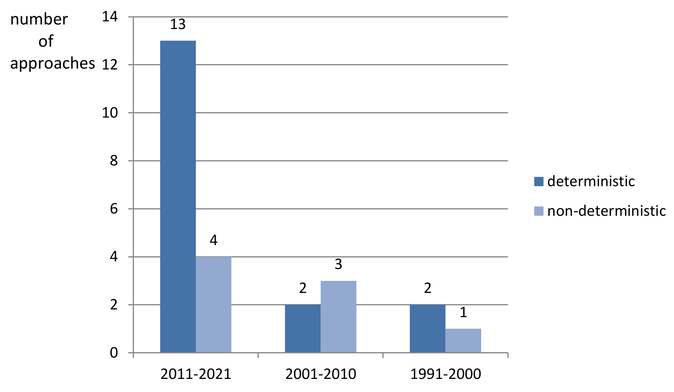
3.2. Deterministic Approaches

Deterministic algorithms are approaches which realize a set of precisely defined steps in order to find a solution to a defined problem. Therefore, they always return the same solution for every run of calculations with the same input data. In this subsection, recent collision avoidance and real time path planning deterministic methods for ships are briefly presented and compared.
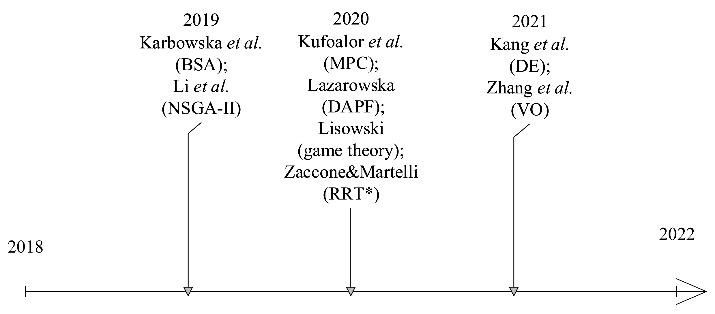
In 2021 [33], authors introduced an approach utilizing the velocity obstacles (VO) method. DCPA and TCPA measures are used in order to assess the collision risk. Certain conditions concerning COLREGs are defined in this approach for different encounter situations: head-on, crossing and overtaking. Radar and AIS data are assumed to be available. Results of simulation tests of encounters with up to four target vessels are given in the paper.
In 2020 [34], authors presented results of Autonomous Surface Vehicle’s (ASV’s) field trails. Collision avoidance in this approach is based on model predictive control (MPC) [35]. Data about target vessels were obtained using AIS. A circular safety region around target ships was assumed, similarly as in [36]. Possible collision avoidance actions are chosen from a set of admissible control behaviors, which include course changes by 0, 15, 30, 45, 60, 75 and 90 degrees or one of the following speed changes: “keep speed”, “slow down” or “stop”. The cost function includes a grounding cost for penalizing control actions that lead to a collision with land. It also takes into account the COLREGs transitional cost, introduced in [37]. It is used in order to prioritize COLREGs compliance maneuvers. Field tests were carried out in the North Sea in November 2017 and covered encounters with up to three target vessels.
In 2020 [38], the author presented a game theory approach applied in order to solve the ships collision avoidance problem. Two types of differential games models are introduced: positional game and matrix game. A strategy characterized by a minimal deviation from the initial path is chosen as the best strategy out of acceptable strategies. COLREGs are taken into account with the use of a logical function resulting from the semantic interpretation of rules. Data concerning target ships are obtained from ARPA. Results of simulation tests carried out using MATLAB are presented in the paper. An encounter situation with 13 target ships is presented as an example. Real navigational data describing this situation received from the radar system with ARPA are used as input data for the algorithms.
In 2019 [39], a Beam Search Algorithm (BSA) was proposed, which was validated by simulations and field experiments on board m/f Wolin. Data from ARPA and/or AIS were assumed as a source of information concerning target ships. The approach is characterized by a very low run time of the algorithm (milliseconds), but it does not include a mechanism forcing the COLREGs compliance of solutions. In [40], the an extension of this method for multi-ship encounters was presented.
In a research shown in 2018 [36], a closed-loop collision avoidance system (COLAV) utilizing a dynamic window (DW) algorithm was applied for an autonomous surface vehicle (ASV). The method was tested in Trondheimsfjord, Norway in May 2017. Data concerning a target ship were obtained with the use of a Simrad Broadband 4G marine radar. Tests included a head-on encounter with one target vessel.
A fuzzy set theory approach for ship’s collision avoidance was introduced in 2017 [41]. Collision risk is assessed using CPA and TCPA measures. Input data concerning target ships are assumed to be obtained from the radar with ARPA. Results presented in the paper cover encounters with up to twelve target vessels. The method, enhanced by an application of a neural network, was compared with an approach based upon the game theory in [42].
In 2016 [43], a deterministic approach—the Trajectory Base Algorithm (TBA)—was introduced and applied using the same framework as in [44], mentioned below. This method is characterized by a low run time, which does not exceed 2 s for scenarios presented in the paper. In 2020 [45], the author proposed another deterministic approach—the Discrete Artificial Potential Field (DAPF) algorithm—using similar assumptions as in the previous works. The algorithm was inspired by the Artificial Potential Field method, but applied on a grid.
In 2015 [46], another deterministic method was proposed- a linear extension algorithm. Two types of maneuvers are possible in this approach: a course change maneuver within a predefined range and speed reduction. A collision avoidance action is calculated, when a Collision Risk Index (CRI) of a pair of ships exceeds a threshold. It is assumed that data concerning target ships are obtained from ARPA. Results of an encounter of four ships are presented and discussed in the paper. Further results, concerning different CRI thresholds are given in [47].
In 2014 [48], authors present results of their research on a collision avoidance method for Unmanned Surface Vehicles (USVs). Presented approach is based upon the Velocity Obstacles (VO) method, with modifications enabling for COLREGs implementation. The method was validated by real experiments with the use of four marine crafts and an autonomy suite called Control Architecture for Robotic Agent Command and Sensing (CARACaS) developed by the Jet Propulsion Laboratory’s (USA).
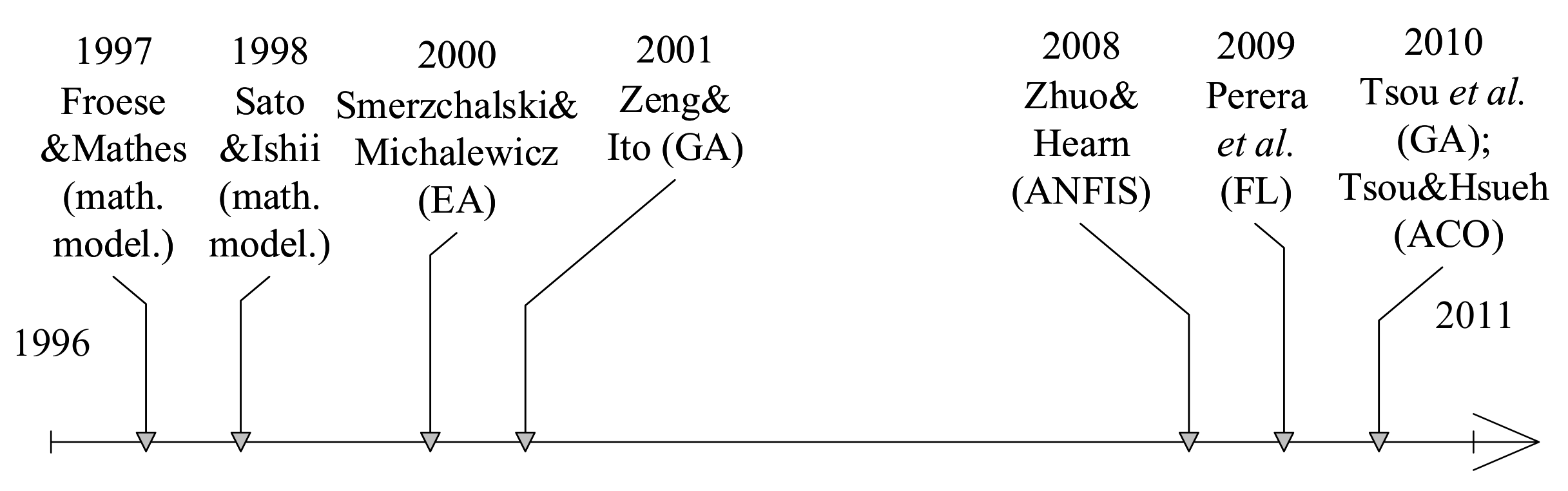
In 2009 [49], a fuzzy logic-based decision making system was introduced. A radar system or a laser scanner is assumed to provide data concerning position and motion parameters of target ships. Presented results cover simulation tests with simple encounters defined by COLREGs, such as head-on, crossing and overtaking.
In 2008 [50], the authors proposed an Adaptive Neuro-Fuzzy Inference system (ANFIS), which determines a proper Time to Take Action (TTA) for the assessed Safety Distance to Approach (SDA) and different course changes. Simulations of encounters with one target vessel are presented in the paper. Data concerning target ships are assumed to be available from AIS.
In 1998 [51], a collision risk assessment method based upon data from a radar and an IR camera was introduced. Obtained information is then used in order to calculate a course alteration required for collision avoidance. The developed system was verified in Nagasaki Prefecture, Japan with one target vessel.
In 1997 [52], the authors presented results of a research on computer-assisted collision avoidance. The aim of the project was to integrate information from ARPA and ECDIS and utilize obtained for determining avoidance maneuvers. A collision avoidance route is calculated with the use of a set of rules, taking COLREGs into account. The approach was validated by simulator tests at the Ship Handling and Simulation Facility (SUSAN) in Hamburg, Germany.
Table 3, Table 4, Table 5, Table 6, Table 7 and 
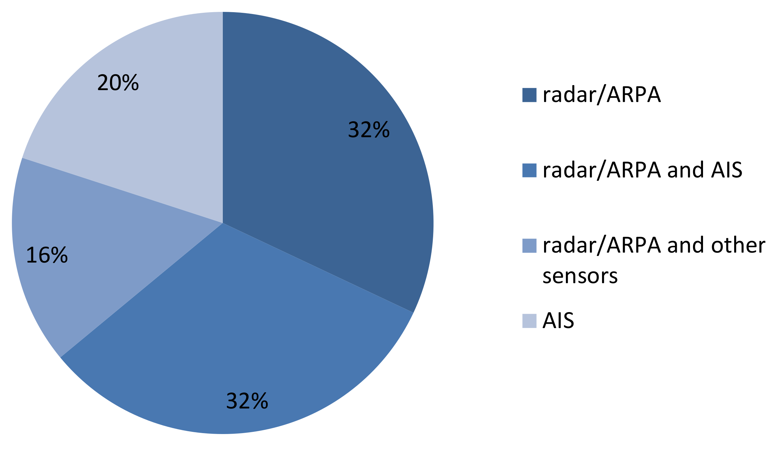
Table 8 contain a list of analyzed approaches with different evaluated features. The main aspect, on which this review was concentrated, is the application of radar remote sensing for target detection and tracking. Therefore, works which did not consider a source of input data concerning encountered ships were not included in this survey. The main focus was put on the application of a marine radar or a radar with ARPA. The usage of AIS or both ARPA and AIS was also taken into account. Another very important issue, evaluated in this state-of-the-art analysis, was the verification of proposed approaches in real experiments. The number of target ships taking part in such evaluations was also analyzed.
In Table 3 and Table 6 the key general features were compared, such as: applied objective function, consideration of static (lands, shallows) and dynamic (target ships) obstacles. Table 4 and Table 7 continue a comparative analysis with the concentration on: a method applied to assure the COLREGs fulfillment, an application of radar remote sensing and/or AIS data reception, and the usage of other sensors such cameras.
In the third part of an analysis, presented in Table 5 and Table 8, a way of methods’ verification is considered. The evaluation covers simulation tests, real experiments, number of target vessels considered in the tests and the run time of an algorithm.

3.3. Non-Deterministic Approaches

Non-deterministic algorithms can return different solutions for every run of calculations with the same input data due to their stochastic nature. These types of approaches use some probabilistic operations during the solution construction process. Many methods classified to this group are population-based algorithms, which apply probabilistic operations to a population of individuals in order to find the best solution for a considered problem. Population-based algorithms inspired by the behavior of animals or other biological organisms are called nature-inspired approaches. Examples of such methods are Evolutionary Algorithms (EA), Genetic Algorithms (GA), ACO (Ant Colony Optimization) or Particle Swarm Optimization (PSO). In this subsection recent collision avoidance and real time path planning methods for ships, classified to the non-deterministic group, are briefly presented and compared.
In 2021 [53], a path planning method based upon a differential evolution (DE) algorithm was proposed, assuming that data concerning target ships are available from navigational aids such as ARPA and AIS. COLREGs are considered by adapting the shape of target ships’ domains. The approach was validated by simulations with up to four target ships.
In 2021, a random sampling approach, based upon a modified version of the Rapidly-exploring Random Tree algorithm (RRT*), for ship collision avoidance was introduced in [54]. The approach takes both static and dynamic obstacles into account. Data concerning obstacles are assumed to be obtained form AIS and nautical charts. In a developed version of the method, presented in [55], the authors also assumed a radar as a source of input data. The cost function considers the path length, the path smoothness and the distance from obstacles. An approach for including COLREGs in the proposed method was presented in [55,56]. The method was verified by simulations with two static obstacles (islands) and two target ships. The run time of the algorithm was not given, but it was assumed that the path is re-planned every 30 s. Presented results also covered situations with a changing strategy of a target ship.
In 2019 [57], a multi-objective optimization algorithm was introduced. Non-dominated sorting genetic algorithm (NSGA-II) is applied in this approach in order to optimize the collision avoidance parameters. Data concerning target ships are assumed to be obtained from the ARPA, but real data were not used in simulations. Tests covered two-ship encounters defined by COLREGs (head-on, crossing and overtaking).
In 2017 [58], authors introduced a heuristic approach for selecting a safe maneuver based upon the determination of the Collision Threat Parameters Area (CTPA). Authors proposed a CTPA-based radar display and a method of automatically selecting a safe maneuver using such a display. The presented results cover an overtaking scenario and a crossing scenario with two target ships. It also takes into account shallows and lands when choosing a safe maneuver.
In a research presented in 2015 [59], a grid-based path search algorithm for the calculation of a ship’s evasive maneuvers was applied. Authors underline the need to consider uncertainties of target tracks in collision avoidance systems. A probabilistic method of target ships handling in the algorithm is applied, which is based upon current positions and motion parameters of target ships along with associated uncertainties. The path search algorithm uses an A* algorithm with a specific cell-neighborhood applied, called the T-neighborhood. This name comes from the T-shaped geometry formed by the adjacent cells. In the paper, an example with three target ships is presented.
In [60], the authors’ approach based upon the A* algorithm, introduced in [61], was tested with the use of a recreational craft “Korona”. The vessel was equipped with a low cost Navico BR24 FMCW radar system. Tests were carried out on the Lake Constance and the Rhine river in Germany. There was one target vessel used in the tests. An example of a collision avoidance trajectory executed by the vessel was presented in the paper. The authors stated that the method enables for real-time path planning.
In 2015, a description of the Hyundai intelligent Collision Avoidance Support System (HiCASS) was presented in [62]. Data concerning target ships are obtained from a radar with ARPA and AIS. The Electronic Navigational Chart (ENC) is applied to obtain data about the coastline. The method applied the A* algorithm in order to determine a collision avoidance action. The system was tested on a 13100 TEU container ship Hyundai Hope on a route from Busan, South Korea to Hamburg, Germany. Presented results include a description of solutions compared with the officer’s actions.
In 2015 [44], a ship’s safe trajectory planning approach utilizing Ant Colony Optimization (ACO) was also proposed. Minimum path length was applied as an objective function. COLREGs are enforced by a proper shape and size of a target ship hexagon domain. Static obstacles are taken into account and are modeled as polygons. ARPA data are assumed to provide target ships’ position and motion parameters. In simulation tests, AIS data from Marine Traffic were used. Further validation of this method with the use of radar system data was presented in [63].
In 2010 [64], a different algorithm based upon the Ant Colony Optimization (ACO) was introduced. Target ship’s data were assumed to be obtained from AIS. Radar data were not considered in this approach. A knowledge base was utilized in order to achieve COLREGs-compliant solutions. The method was verified by simulations with up to four target vessels.
In [65], the authors presented an approach similar to that introduced in [64]. Here, a different optimization method was applied—a genetic algorithm (GA). Other assumptions were similar. AIS was assumed to be utilized in order to obtain information concerning target ships. A fuzzy domain, estimated with the use of ship’s length, speed and sea state, introduced in [66], was applied in this research. Results of simulation tests with one target ship were presented in the paper.
In 2001 [18], an approach utilizing a genetic algorithm and data from the ARPA system was introduced. The method was tested on a vessel “Shioji Maru”. In the paper, a situation with 18 target ships is presented.
In 2000 [19], an Evolutionary Algorithm-based approach to safe trajectory planning was presented. Presented solutions covered simulation tests with up to three target ships and with static obstacles (lands, canals, restricted zones). Data concerning target ships were assumed to be obtained from ARPA.
Table 6. A comparison of non-deterministic methods applying radar remote sensing and other sensors—part 1.
MethodYearObjectiveStatic Obs.Dynamic Obs.
DE2021Min. pathNotTS
[53]lengthconsidereddomain
RRT*2020CostSet ofSafe
[54]functionpointsdistance
NSGA-II2019Pareto-NotOS and TS
[57]optimal setconsidereddomain
CTPA2017Pareto-Lands,Elliptical
[58]optimalityshallowsdomain
A*2015Min. pathPossibleCircular
[59]length(not considered)domain
A*2015Time integral ofFromDetected by
[62] collision risk (CR)ENCARPA, AIS
ACO2015Min. pathModeled asHexagon
[44]lengthpolygonsdomain
ACO2010Min. pathNotFuzzy
[64]lengthconsidereddomain [66]
GA2010Min. pathNotFuzzy
[64]lengthconsidereddomain [66]
GA2001Economy, safetyNotDetected
[18]rulesconsideredby ARPA
EA2000CostModeled asHexagon
[19]functionpolygonsdomain
Table 7. A comparison of non-deterministic methods applying radar remote sensing and other sensors—part 2.
MethodYearCOLREGsRadar DataAIS, Other Sensors
DE2021TS domainARPA assumedAIS assumed
[53]shape-no real data-no real data
RRT*2020ConsideredRadar assumedAIS, nautical charts
[54][56]in [55]-no real data
NSGA-II2019Set fulfillingARPA assumedNot
[57]COLREGs-no real dataconsidered
CTPA2017Starboard overARPA assumedAIS, ENC assumed
[58]port side-no real data-no real data
A*2015DomainLow costNot
[59]shaperadarconsidered
A*2015ExpertARPAAIS, ENC
[62]system
ACO2015DomainARPA assumedAIS assumed
[44]shape, size-no real data(Marine Traffic)
ACO2010KnowledgeNotAIS assumed
[64]baseconsidered-no real data
GA2010Set ofNotAIS assumed
[64]rulesconsidered-no real data
GA2001FitnessARPANot
[18]function-real dataconsidered
EA2000DomainARPA assumedNot
[19]shape, size-no real dataconsidered
Table 8. A comparison of non-deterministic methods applying radar remote sensing and other sensors—part 3.
MethodYearSimulationsReal Exp.Max No of TSsRun Time
DE [53]2021YesNo4Not given
RRT* [54]2020YesNo2Re-planning every 30 sec.
NSGA-II [57]2019YesNo1Not given
CTPA [58]2017YesNo2Maximum 1 min.
A* [59]2015YesYes results in [60]3Not given
A* [62]2015NoYesNot specifiedNot given
ACO [44]2015YesNo7Within 1 min.
ACO [64]2010YesNo410–20 sec.
GA [64]2010YesNo1Within 1 min.
GA [18]2001NoYes18Not given
EA [19]2000YesNo3Average 55 sec.

4. Discussion

The most recent approaches were also compared with older methods in order to more easily perceive the advancements and trends in the area of collision avoidance for ships. In total, 25 approaches on collision avoidance and path planning for ships from the years 1997–2021 were analyzed in details. Timelines concerning compared methods are presented in Figure 6, Figure 7 and Figure 8. Algorithms were investigated in terms of a few different aspects. Out of 25 analyzed methods, 32% used or assumed the usage of a radar system as a source of TSs data, another 32%-of both radar and AIS. In total, 16% of analyzed approaches declared or applied a radar system and other sensors, such as cameras, and 20% used only AIS. A chart presenting these statistics is given in Figure 9.
Figure 10 presents a comparison of methods in terms of their general operation principle. All approaches are divided into deterministic and non-deterministic. Methods were also assigned to different groups, according to the time, when they were reported. Three time periods were distinguished: 1991–2000, 2001–2010 and 2011–2021. In total, 17 analyzed methods were introduced most recently, in the years 2011–2021, 5 in the years 2001–2010 and 3 in the years 1991–2000. Most of the compared approaches are of deterministic type, but that cannot be treated as a general trend, as only methods referring to the usage of radar remote sensing, AIS or other sensors, were compared in this review.
Figure 11 shows a chart comparing analyzed approaches in terms of applied verification method. In total, 67% out of 25 algorithms were verified by simulations only, 21% by field experiments and 13% by both simulations and real experiments.
Methods characterized by low run time, such as [33,34,36,38,39,43,45,48,54], can be regarded as the most practical approaches, especially for the use in USV motion control system. Methods verified by field tests also seem to be the most promising, such as [34,36,39,48,60]. The most versatile will be the methods which have the ability to take also static obstacle (lands, shallows) into account, and these, which have a mechanism enforcing the COLREGs compliance of solutions.

5. Conclusions

The aim of the paper was to present a comprehensive review of different collision avoidance and real-time path planning methods for ships, with a concentration on radar remote sensing and the usage of other sensors for target ships’ detection and tracking. The analysis allowed to determine many promising approaches in the recent literature.
The analysis of different recent collision avoidance and real-time path planning algorithms for ships allowed to state that among the most important features, the method should fulfill are: the COLREGs compliance of solutions, near-real run time, reliability of input data and repeatability of results for every run of calculations with the same input data.
The study also enabled to define future research directions, such as the issue of data fusion from a radar system with ARPA and AIS, and the need to validate the methods in field experiments, e.g., with the use of USVs.
The analysis of recent review papers within the considered topic allowed to perceive, that a survey of ship detection methods in terms of their application in the SA module of the ANS for MASS might constitute a very valuable contribution. Such analysis should put an emphasis on deep learning methods, which seem to be very popular and provide promising results in the application to ship detection task.

Funding

This research was funded by a research project of the Electrical Engineering Faculty, Gdynia Maritime University, Poland, No. WE/2021/PZ/02: “Control theory and artificial intelligence techniques in optimal and safe ship operation”.

Conflicts of Interest

The authors declare no conflict of interest.

Abbreviations

The following abbreviations are used in this manuscript:
AISAutomatic Information System
ANFISAdaptive Neuro-Fuzzy Inference system
ANSAutonomous Navigation System
ACOAnt Colony Optimization
ARPAAutomatic Radar Plotting Aid
ASAdvanced Sensor module
ASVAutonomous Surface Vehicle
AUVAutonomous Underwater Vehicle
BSABeam Search Algorithm
CACollision Avoidance module
COLREGsInternational Regulations for Preventing Collisions at Sea
CPAClosest Point of Approach
CRICollision Risk Index
CTPACollision Threat Parameters Area
DAPFDiscrete Artificial Potential Field
DCPADistance at the Closest Point of Approach
DEDifferential Evolution algorithm
DWDynamic Window algorithm
EAEvolutionary Algorithm
EBLelectronic bearing line
ECDISElectronic Chart Display and Information System
EMCIPEuropean Marine Casualty Information Platform
EMSAEuropean Maritime Safety Agency
ENCElectronic Navigational Chart
FLFuzzy Logic
GAGenetic algorithm
IMOInternational Maritime Organization
LELinear Extension
MASSMaritime Autonomous Surface Ships
MPCModel Predictive Control
NSGA-IInon-dominated sorting genetic algorithm
OSown ship
OSDOwn Ship Data
RADARRAdio Detection Furthermore, Ranging
R-CNNRegion-based Convolutional Neural Network
RCSthe radar cross-sectional area
RPRoute Planning module
SASituation Awareness module
SARSynthetic Aperture Radar
SDASafety Distance to Approach
SFSensor Fusion module
TBATrajectory Base Algorithm
TCPATime to the Closest Point of Approach
TStarget ship
TTtarget tracking
TTATime to Take Action
TTMTracked Target Message
USVUnmanned Surface Vehicle
VOVelocity Obstacles method

References

  1. The International Maritime Organization (IMO). Available online: Https://www.imo.org/en/MediaCentre/PressBriefings/Pages/08-MSC-99-MASS-scoping.aspx (accessed on 11 May 2021).
  2. Li, J.; Qu, C.; Shao, J. Ship detection in SAR images based on an improved faster R-CNN. In Proceedings of the 2017 SAR in Big Data Era: Models, Methods and Applications (BIGSARDATA), Beijing, China, 13–14 November 2017; pp. 1–6. [Google Scholar] [CrossRef]
  3. Park, J.; Lee, J.; Seto, K.; Hochberg, T.; Wong, B.A.; Miller, N.A.; Takasaki, K.; Kubota, H.; Oozeki, Y.; Doshi, S.; et al. lluminating dark fishing fleets in North Korea. Sci. Adv. 2020, 6, eabb1197. [Google Scholar] [CrossRef] [PubMed]
  4. Li, B.; Liu, B.; Huang, L.; Guo, W.; Zhang, Z.; Yu, W. OpenSARShip 2.0: A large-volume dataset for deeper interpretation of ship targets in Sentinel-1 imagery. In Proceedings of the 2017 SAR in Big Data Era: Models, Methods and Applications (BIGSARDATA), Beijing, China, 13–14 November 2017; pp. 1–5. [Google Scholar] [CrossRef]
  5. Zhang, T.; Zhang, X.; Ke, X.; Zhan, X.; Shi, J.; Wei, S.; Pan, D.; Li, J.; Su, H.; Zhou, Y.; et al. LS-SSDD-v1.0: A Deep Learning Dataset Dedicated to Small Ship Detection from Large-Scale Sentinel-1 SAR Images. Remote Sens. 2020, 12, 2997. [Google Scholar] [CrossRef]
  6. EMSA Annual Overview of Marine Casualties and Incidents. Available online: Http://www.emsa.europa.eu/newsroom/latest-news/item/4266-annual-overview-of-marine-casualties-and-incidents-2020.html (accessed on 11 May 2021).
  7. Bole, A.; Wall, A.; Norris, A. Radar and ARPA Manual, 3rd ed.; Elsevier Butterworth-Heineman: Oxford, UK, 2014. [Google Scholar]
  8. Kirkpatrick, G.M. Development of A Monopulse Radar System. IEEE Trans. Aerosp. Electron. Syst. 2009, 45, 807–818. [Google Scholar] [CrossRef]
  9. Kongsberg Maritime Ltd. (Norway). Available online: Https://www.kongsberg.com/maritime/about-us/who-we-are-kongsberg-maritime/Our-history/ (accessed on 11 August 2021).
  10. Furuno Electric Co., Ltd. (Japan). Marine Radar Model FAR-2107/FAR-2107-BB/FAR-2807 Operator’s Manual; Furuno Electric Co., Ltd.: Hyogo, Japan, 2015. [Google Scholar]
  11. Sadler, D. The Mathematics of Collision Avoidance at Sea. J. Navig. 1957, 10, 306–319. [Google Scholar] [CrossRef]
  12. Calvert, E. Manoeuvres to Ensure the Avoidance of Collision. J. Navig. 1960, 13, 127–137. [Google Scholar] [CrossRef]
  13. Calvert, E. A Comparison of Two Systems for Avoiding Collision. J. Navig. 1961, 14, 379–401. [Google Scholar] [CrossRef]
  14. Garcia-Frias, J. Anti-collision Radar Sectors. J. Navig. 1960, 13, 316–323. [Google Scholar] [CrossRef]
  15. Wylie, F. The Calvert Methods of Manoeuvring to Avoid Collision at Sea and of Radar Display. J. Navig. 1960, 13, 455–464. [Google Scholar] [CrossRef] [Green Version]
  16. Wylie, F. Mathematics and the Collision Regulations. J. Navig. 1962, 15, 104–112. [Google Scholar] [CrossRef] [Green Version]
  17. Hollingdale, S. The Mathematics of Collision Avoidance in Two Dimensions. J. Navig. 1961, 14, 243–261. [Google Scholar] [CrossRef]
  18. Zeng, X.-M.; Ito, M. Planning a collision avoidance model for ship using genetic algorithm. In Proceedings of the 2001 IEEE International Conference on Systems, Man and Cybernetics, Tucson, AZ, USA, 7–10 October 2001; Volume 4, pp. 2355–2360. [Google Scholar] [CrossRef]
  19. Smierzchalski, R.; Michalewicz, Z. Modeling of ship trajectory in collision situations by an evolutionary algorithm. IEEE Trans. Evol. Comput. 2000, 4, 227–241. [Google Scholar] [CrossRef] [Green Version]
  20. Vagale, A.; Oucheikh, R.; Bye, R.T.; Osen, O.L.; Fossen, T.I. Path planning and collision avoidance for autonomous surface vehicles I: A review. J. Mar. Sci. Technol. 2021. [Google Scholar] [CrossRef]
  21. Vagale, A.; Bye, R.T.; Oucheikh, R.; Osen, O.L.; Fossen, T.I. Path planning and collision avoidance for autonomous surface vehicles II: A comparative study of algorithms. J. Mar. Sci. Technol. 2021. [Google Scholar] [CrossRef]
  22. Huang, Y.; Chen, L.; Chen, P.; Negenborn, R.R.; van Gelder, P.H.A.J.M. Ship collision avoidance methods: State-of-the-art. Saf. Sci. 2020, 121, 451–473. [Google Scholar] [CrossRef]
  23. Singh, Y.; Sharma, S.; Hatton, D.; Sutton, R. Optimal path planning of unmanned surface vehicles. Indian J. Geo Mar. Sci. 2018, 47, 1325–1334. [Google Scholar]
  24. Campbell, S.; Naeem, W.; Irwin, G.W. A review on improving the autonomy of unmanned surface vehicles through intelligent collision avoidance manoeuvres. Annu. Rev. Control 2012, 36, 267–283. [Google Scholar] [CrossRef] [Green Version]
  25. Liu, Z.; Zhang, Y.; Yu, X.; Yuan, C. Unmanned surface vehicles: An overview of developments and challenges. Annu. Rev. Control 2016, 41, 71–93. [Google Scholar] [CrossRef]
  26. Liu, Y.; Bucknall, R. Path planning algorithm for unmanned surface vehicle formations in a practical maritime environment. Ocean Eng. 2015, 97, 126–144. [Google Scholar] [CrossRef]
  27. Zeng, Z.; Lian, L.; Sammut, K.; He, F.; Tang, Y.; Lammas, A. A survey on path planning for persistent autonomy of autonomous underwater vehicles. Ocean Eng. 2015, 110, 303–313. [Google Scholar] [CrossRef]
  28. Szlapczynski, R.; Szlapczynska, J. Review of ship safety domains: Models and applications. Ocean Eng. 2017, 145, 277–289. [Google Scholar] [CrossRef]
  29. Tu, E.; Zhang, G.; Rachmawati, L.; Rajabally, E.; Huang, G. Exploiting AIS Data for Intelligent Maritime Navigation: A Comprehensive Survey From Data to Methodology. IEEE Trans. Intell. Transp. Syst. 2018, 19, 1559–1582. [Google Scholar] [CrossRef]
  30. Tam, C.; Bucknall, R.; Greig, A. Review of Collision Avoidance and Path Planning Methods for Ships in Close Range Encounters. J. Navig. 2009, 62, 455–476. [Google Scholar] [CrossRef]
  31. Statheros, T.; Howells, G.; Maier, K. Autonomous Ship Collision Avoidance Navigation Concepts, Technologies and Techniques. J. Navig. 2008, 61, 129–142. [Google Scholar] [CrossRef] [Green Version]
  32. Naeem, W.; Irwin, G.W.; Yang, A. COLREGs-based collision avoidance strategies for unmanned surface vehicles. Mechatron 2012, 22, 669–678. [Google Scholar] [CrossRef]
  33. Zhang, W.; Yan, C.; Lyu, H.; Wang, P.; Xue, Z.; Li, Z.; Xiao, B. COLREGS-based Path Planning for Ships at Sea Using Velocity Obstacles. IEEE Access 2021, 9, 32613–32626. [Google Scholar] [CrossRef]
  34. Kufoalor, D.K.M.; Johansen, T.A.; Brekke, E.F.; Hepsø, A.; Trnka, K. Autonomous maritime collision avoidance: Field verification of autonomous surface vehicle behavior in challenging scenarios. J. Field Robot. 2020, 37, 387–403. [Google Scholar] [CrossRef]
  35. Kufoalor, D.K.M.; Wilthil, E.; Hagen, I.B.; Brekke, E.F.; Johansen, T.A. Autonomous COLREGs-Compliant Decision Making using Maritime Radar Tracking and Model Predictive Control. In Proceedings of the 2019 18th European Control Conference (ECC), Naples, Italy, 25–28 June 2019; pp. 2536–2542. [Google Scholar] [CrossRef] [Green Version]
  36. Eriksen, B.H.; Wilthil, E.F.; Flåten, A.L.; Brekke, E.F.; Breivik, M. Radar-based maritime collision avoidance using dynamic window. In Proceedings of the 2018 IEEE Aerospace Conference, Big Sky, MT, USA, 3–10 March 2018; pp. 1–9. [Google Scholar] [CrossRef]
  37. Hagen, I.B.; Kufoalor, D.K.M.; Brekke, E.F.; Johansen, T.A. MPC-based Collision Avoidance Strategy for Existing Marine Vessel Guidance Systems. In Proceedings of the 2018 IEEE International Conference on Robotics and Automation (ICRA), Brisbane, Australia, 21–25 May 2018; pp. 7618–7623. [Google Scholar] [CrossRef]
  38. Lisowski, J. Game Control Methods Comparison when Avoiding Collisions with Multiple Objects Using Radar Remote Sensing. Remote Sens. 2020, 12, 1573. [Google Scholar] [CrossRef]
  39. Karbowska-Chilinska, J.; Koszelew, J.; Ostrowski, K.; Kuczynski, P.; Kulbiej, E.; Wolejsza, P. Beam Search Algorithm for Ship Anti-Collision Trajectory Planning. Sensors 2019, 19, 5338. [Google Scholar] [CrossRef] [Green Version]
  40. Koszelew, J.; Karbowska-Chilinska, J.; Ostrowski, K.; Kuczyński, P.; Kulbiej, E.; Wołejsza, P. Beam Search Algorithm for Anti-Collision Trajectory Planning for Many-to-Many Encounter Situations with Autonomous Surface Vehicles. Sensors 2020, 20, 4115. [Google Scholar] [CrossRef]
  41. Mohamed-Seghir, M. The fuzzy properties of the ship control in collision situations. In Proceedings of the 2017 IEEE International Conference on INnovations in Intelligent SysTems and Applications (INISTA), Gdynia, Poland, 3–5 July 2017; pp. 107–112. [Google Scholar] [CrossRef]
  42. Lisowski, J.; Mohamed-Seghir, M. Comparison of Computational Intelligence Methods Based on Fuzzy Sets and Game Theory in the Synthesis of Safe Ship Control Based on Information from a Radar ARPA System. Remote Sens. 2019, 11, 82. [Google Scholar] [CrossRef] [Green Version]
  43. Lazarowska, A. A Trajectory Base Method for Ship’s Safe Path Planning. Procedia Comput. Sci. 2016, 96, 1022–1031. [Google Scholar] [CrossRef] [Green Version]
  44. Lazarowska, A. Ship’s Trajectory Planning for Collision Avoidance at Sea Based on Ant Colony Optimisation. J. Navig. 2015, 68, 291–307. [Google Scholar] [CrossRef] [Green Version]
  45. Lazarowska, A. A Discrete Artificial Potential Field for Ship Trajectory Planning. J. Navig. 2020, 73, 233–251. [Google Scholar] [CrossRef]
  46. Zhang, J.; Zhang, D.; Yan, X.; Haugen, S.; Guedes Soares, C. A distributed anti-collision decision support formulation in multi-ship encounter situations under COLREGs. Ocean Eng. 2015, 105, 336–348. [Google Scholar] [CrossRef]
  47. Hu, Y.; Zhang, A.; Tian, W.; Zhang, J.; Hou, Z. Multi-Ship Collision Avoidance Decision-Making Based on Collision Risk Index. J. Mar. Sci. Eng. 2020, 8, 640. [Google Scholar] [CrossRef]
  48. Kuwata, Y.; Wolf, M.T.; Zarzhitsky, D.; Huntsberger, T.L. Safe Maritime Autonomous Navigation With COLREGS, Using Velocity Obstacles. IEEE J. Ocean. Eng. 2014, 39, 110–119. [Google Scholar] [CrossRef]
  49. Perera, L.; Carvalho, J.; Guedes Soares, C. Autonomous Guidance and Navigation based on the COLREGs rules and regulations of collision avoidance. In Proceedings of the International Workshop “Advanced Ship Design for Pollution Prevention”, Split, Croatia, 23–24 November 2009; pp. 205–216. [Google Scholar] [CrossRef]
  50. Zhuo, Y.; Hearn, G.E. A ship based intelligent anti-collision decision-making support system utilizing trial manoeuvres. In Proceedings of the 2008 Chinese Control and Decision Conference, Yantai, China, 2–4 July 2008; pp. 3982–3987. [Google Scholar] [CrossRef]
  51. Sato, Y.; Ishii, H. Study of a collision-avoidance system for ships. Control Eng. Pract. 1998, 6, 1141–1149. [Google Scholar] [CrossRef]
  52. Froese, J.; Mathes, S. Computer-assisted collision avoidance using ARPA and ECDIS. Dtsch. Hydrogr. Z. 1997, 49, 519–529. [Google Scholar] [CrossRef]
  53. Kang, Y.T.; Chen, W.J.; Zhu, D.Q.; Wang, J.H. Collision avoidance path planning in multi-ship encounter situations. J. Mar. Sci. Technol. 2021. [Google Scholar] [CrossRef]
  54. Zaccone, R.; Martelli, M. A collision avoidance algorithm for ship guidance applications. J. Mar. Eng. Technol. 2020, 19, 62–75. [Google Scholar] [CrossRef]
  55. Zaccone, R. COLREG-Compliant Optimal Path Planning for Real-Time Guidance and Control of Autonomous Ships. J. Mar. Sci. Eng. 2021, 9, 405. [Google Scholar] [CrossRef]
  56. Zaccone, R.; Martelli, M.; Figari, M. A COLREG-Compliant Ship Collision Avoidance Algorithm. In Proceedings of the 18th European Control Conference (ECC), Naples, Italy, 25–28 June 2019; pp. 2530–2535. [Google Scholar] [CrossRef]
  57. Li, J.; Wang, H.; Zhao, W.; Xue, Y. Ship’s Trajectory Planning Based on Improved Multiobjective Algorithm for Collision Avoidance. J. Adv. Transp. 2019. [Google Scholar] [CrossRef]
  58. Szlapczynska, J.; Szlapczynski, R. Heuristic Method of Safe Manoeuvre Selection Based on Collision Threat Parameters Areas. TransNav Int. J. Mar. Navig. Saf. Sea Transp. 2017, 11, 591–596. [Google Scholar] [CrossRef] [Green Version]
  59. Blaich, M.; Köhler, S.; Reuter, J.; Hanh, A. Probabilistic Collision Avoidance for Vessels. IFAC-PapersOnLine 2015, 48, 69–74. [Google Scholar] [CrossRef]
  60. Schuster, M.; Blaich, M.; Reuter, J. Collision Avoidance for Vessels using a Low-Cost Radar Sensor. IFAC Proc. Vol. 2014, 47, 9673–9678. [Google Scholar] [CrossRef] [Green Version]
  61. Blaich, M.; Rosenfelder, M.; Schuster, M.; Bittel, O.; Reuter, J. Fast grid based collision avoidance for vessels using A* search algorithm. In Proceedings of the 2012 17th International Conference on Methods & Models in Automation & Robotics (MMAR), Miedzyzdroje, Poland, 27–30 August 2012; pp. 385–390. [Google Scholar] [CrossRef]
  62. Kim, D.; Ahn, K.; Oh, K.-S.; Shim, S.; Kim, Y. A study on the verification of collision avoidance support system in real voyages. In Proceedings of the 2015 International Association of Institutes of Navigation World Congress (IAIN), Prague, Czech Republic, 20–23 October 2015; pp. 1–6. [Google Scholar]
  63. Lazarowska, A. Verification of Ship’s Trajectory Planning Algorithms Using Real Navigational Data. TransNav Int. J. Mar. Navig. Saf. Sea Transp. 2019, 13, 559–564. [Google Scholar] [CrossRef]
  64. Tsou, M.; Hsueh, C.-K. The Study Of Ship Collision Avoidance Route Planning By Ant Colony Algorithm. J. Mar. Sci. Technol. 2010, 18, 746–756. [Google Scholar] [CrossRef]
  65. Tsou, M.; Kao, S.; Su, C. Decision Support from Genetic Algorithms for Ship Collision Avoidance Route Planning and Alerts. J. Navig. 2010, 63, 167–182. [Google Scholar] [CrossRef]
  66. Kao, S.; Lee, K.; Chang, K.; Ko, M. A Fuzzy Logic Method for Collision Avoidance in Vessel Traffic Service. J. Navig. 2007, 60, 17–31. [Google Scholar] [CrossRef]
Figure 1. Measurement of relative bearing.
Remotesensing 13 03265 g001
Figure 2. Measurement of true bearing.
Remotesensing 13 03265 g002
Figure 3. A general block diagram of a marine radar.
Remotesensing 13 03265 g003
Figure 4. Static trial maneuver in Furuno radar.
Remotesensing 13 03265 g004
Figure 5. Dynamic trial maneuver in Furuno radar.
Remotesensing 13 03265 g005
Figure 6. Timeline showing compared approaches from the years 1997–2010.
Remotesensing 13 03265 g006
Figure 7. Timeline showing compared approaches from the years 2014–2018.
Remotesensing 13 03265 g007
Figure 8. Timeline showing compared approaches from the years 2019–2021.
Remotesensing 13 03265 g008
Figure 9. A comparison of analyzed approaches: source of input data.
Remotesensing 13 03265 g009
Figure 10. A comparison of analyzed approaches: verification method.
Remotesensing 13 03265 g010
Figure 11. A comparison of analyzed approaches: method type.
Remotesensing 13 03265 g011
Table 1. An example of a Tracked Target Message-TTM transmitted by a radar.
$RATTM,26,5.76,133.8,T,22.87,232.7,R,
5.70,2.3,N,,T,,,M*22’
RASender ID (radar)
TTMSentence ID (Tracked Target Message)
26Target number assigned by ARPA (26), 00 to 99
5.76Target distance from own ship (5.76 NM)
133.8Target bearing from own ship (133.8 ° )
TTarget bearing orientation (true), R-relative
22.87Target speed (22.87 knots)
232.7Target course (232.7 ° )
RTarget course orientation (relative), T-true
5.7Distance at closest point of approach (5.7 NM)
2.3Time to closest point of approach (2.3 min)
NDistance and speed units (NM and knots)
, ,Target label on ARPA (blank)
TTarget status (tracking), L-lost, Q-acquired
, ,Reference target (blank)
, ,Time of data in UTC (blank)
MType of target acquisition (manual), A-automatic
*22Checksum
Table 2. An example of an Own Ship Data message-OSD transmitted by a radar.
$RAOSD,087.2,A,087.0,W,11.4,W,,,N*70
RASender ID (radar)
OSDSentence ID (Own Ship Data)
087.2Heading (87.2 ° )
AHeading status (valid), V-invalid
087.0Vessel course (87.0 ° )
WCourse reference (water-referenced)
11.4Vessel speed (22.87 knots)
WSpeed reference (water-referenced)
, ,Vessel set (blank)
, ,Vessel drift (blank)
NSpeed units (knots)
*70Checksum
Table 3. A comparison of deterministic methods applying radar remote sensing and other sensors—part 1.
MethodYearObjectiveStatic Obs.Dynamic Obs.
VO2021VO utilityTS withDCPA,
[33]function0 speedTCPA
MPC2020CostGroundingCircle safety
[34]functioncostregion
DAPF2020Min. pathModeled asHexagon
[45]lengthpolygonsdomain
Game theory2020Min. deviationPossibleSafe
[38]from path(not considered)distance
BSA2019Min. pathNotDCPA,
[39]lengthconsideredTCPA
DW2018Surge,NotCircle safety
[36]yaw rateconsideredregion
FL2017MembershipTS withCPA,
[41]function0 speedTCPA
TBA2016Min. pathModeled asHexagon
[43]lengthpolygonsdomain
LE2015PredefinedNotOS and TS
[46]rangeconsidereddomain
VO2014Min. deviationYesCone-
[48]velocity shaped
FL2009FuzzyNotOS
[49]decisionconsidereddomain
ANFIS2008TTANotSDA
[50] considered
Math. model.1998Required courseNotDCPA,
[51]alterationconsideredTCPA
Math. model.1997Required courseChartCPA,
[52]alterationobjectsTCPA
Table 4. A comparison of deterministic methods applying radar remote sensing and other sensors—part 2.
MethodYearCOLREGsRadar DataAIS, Other Sensors
VO2021CertainRadar assumedAIS assumed
[33]conditions-no real data-no real data
MPC2020COLREGsMarine radarAIS
[34]cost-not used-real data
DAPF2020DomainARPAAIS, ECDIS assumed
[45]shape, size-real data-no real data
Game theory2020LogicalARPANot
[38]function-real dataconsidered
BSA2019NotARPAAIS
[39]considered-real data-real data
DW2018NotMarineAIS, other
[36]consideredradar(not used)
FL2017ConsideredARPANot
[41](no details)-real dataconsidered
TBA2016DomainARPA assumedAIS, ECDIS assumed
[43]shape, size-no real data-no real data
LE2015ConsideredARPA assumedNot
[46](no details)-no real dataconsidered
VO2014Set ofRadar assumedStereo
[48]constraints-no real datacameras
FL2009KnowledgeRadarLaser
[49]basesystemscanner
ANFIS2008FuzzyNotAIS assumed
[50]rulesconsidered-no real data
Math. model.1998ConsideredRadarIR camera,
[51](no details)systemGPS
Math. model.1997Set ofARPA assumedECDIS
[52]rules
Table 5. A comparison of deterministic methods applying radar remote sensing and other sensors—part 3.
MethodYearSimulationsReal Exp.Max No of TSsRun Time
VO [33]2021YesNo4Almost real-time
MPC [34]2020NoNorth Sea Nov. 2017 ASV3Every 5 sec.
DAPF [45]2020YesNo9Less than 1 sec.
Game theory [38]2020YesNo13Very low [ms]
BSA [39]2019Yesm/f Wolin3Very low [ms]
DW [36]2018NoNorway May 2017 ASV1 (head-on)Real-time
FL [41]2017YesNo12Not given
TBA [43]2016YesNo4Less than 2 sec.
LE [46]2015YesNo4Not given
VO [48]2014YesOn-water test (USV)3very low 1 sec.
FL [49]2009YesNo1Not given
ANFIS [50]2008YesNo1Not given
Math. model. [51]1998NoNagasaki, Japan1Not given
Math. model. [52]1997SimulatorNoNot specifiedNot given
Publisher’s Note: MDPI stays neutral with regard to jurisdictional claims in published maps and institutional affiliations.

