
Using Multisource Satellite Data to Investigate Lake Area, Water Level, and Water Storage Changes of Terminal Lakes in Ungauged Regions


Abstract
:1. Introduction
2. Study Area
3. Data and Methodology
3.1. Data
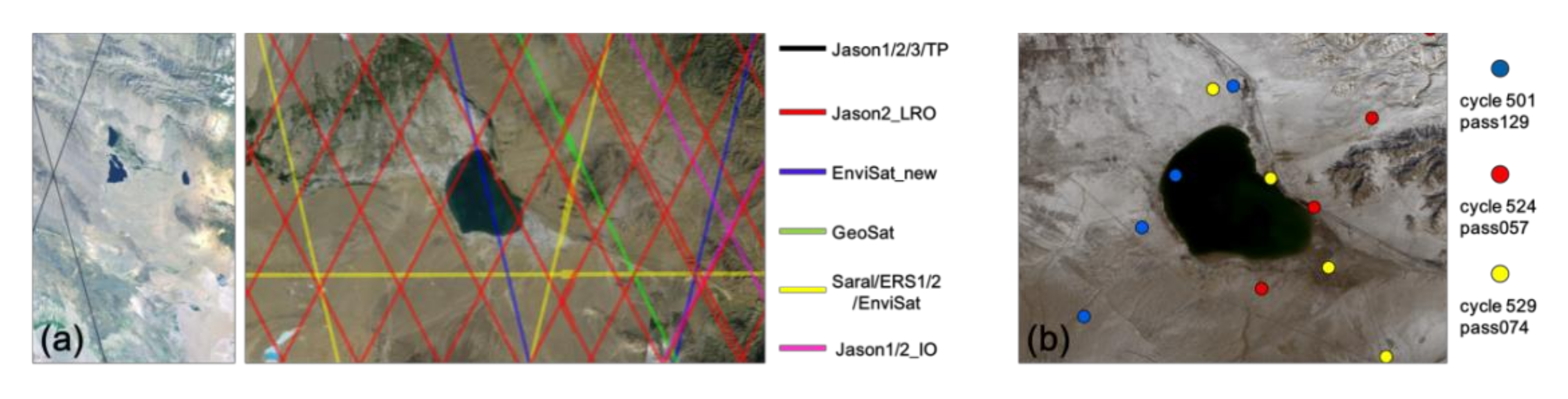
3.1.1. Satellite Altimetry Datasets
3.1.2. Satellite Images and Digital Map
3.1.3. Hydro-Climatic Data and Cropland Maps
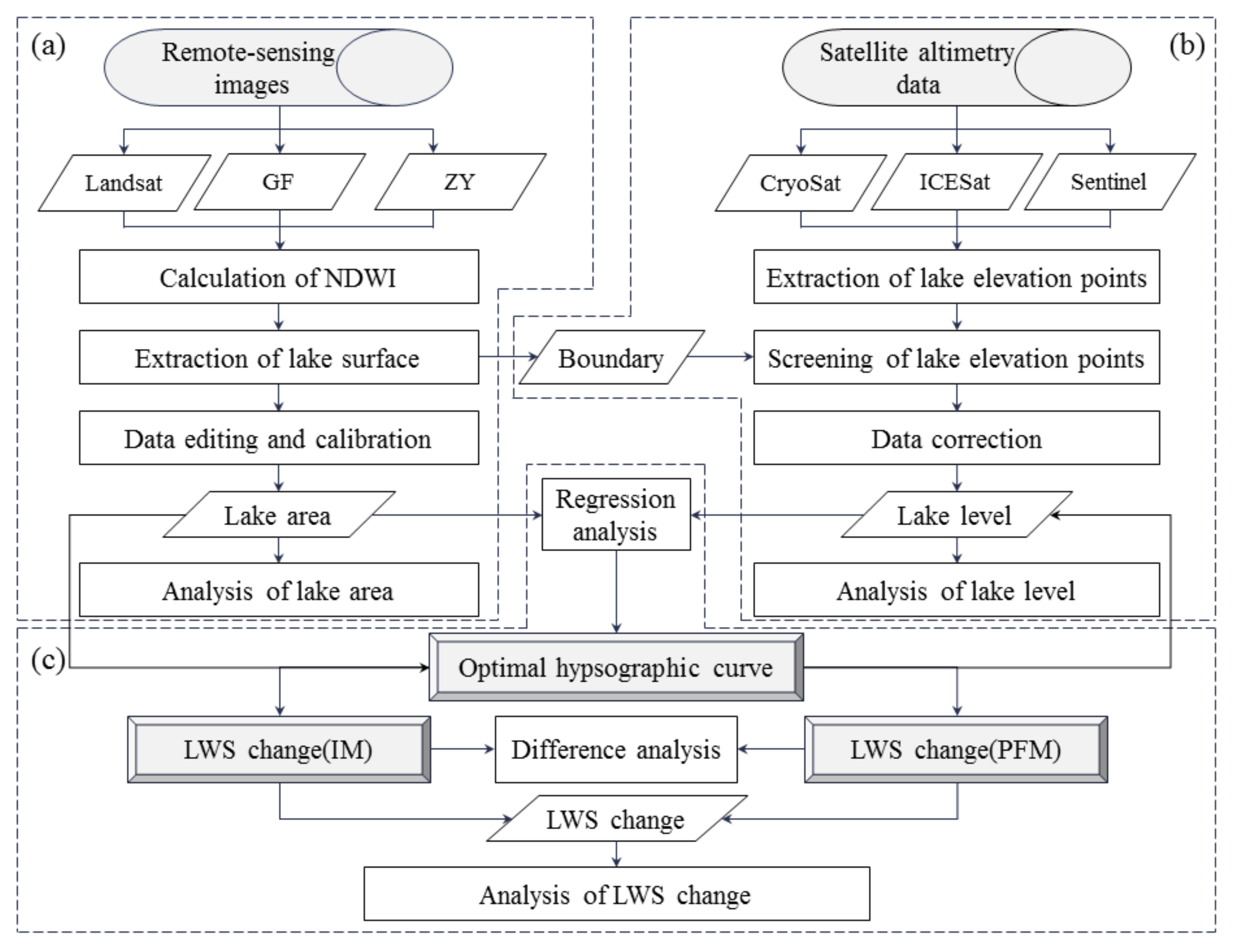
3.2. Methodology
3.2.1. Extraction of the Lake Area
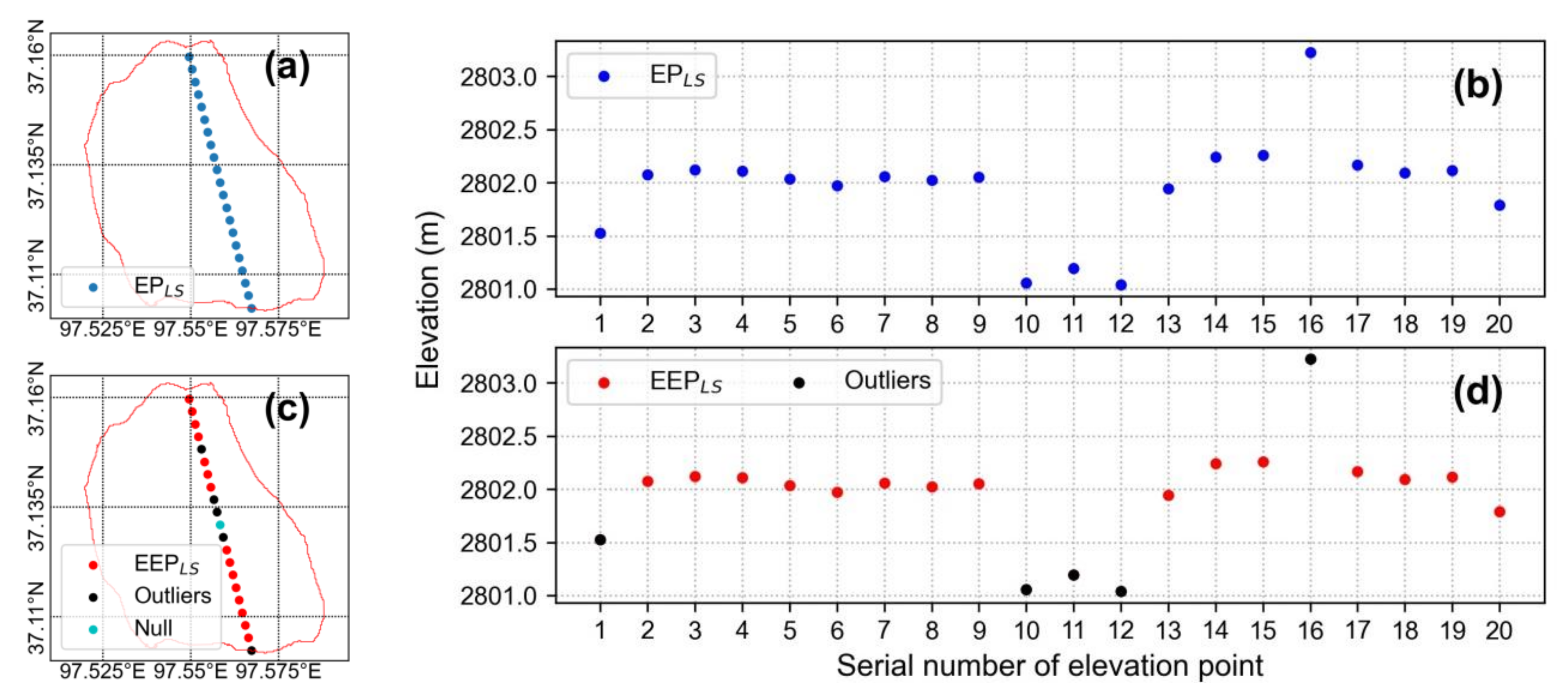
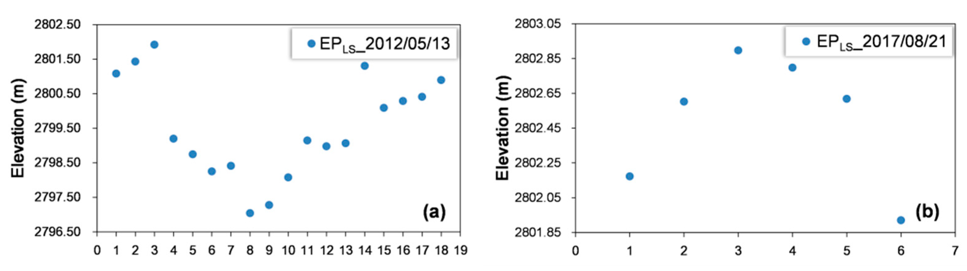
3.2.2. Extraction of the Lake Water Level
3.2.3. Estimation of the Lake Water Storage Changes
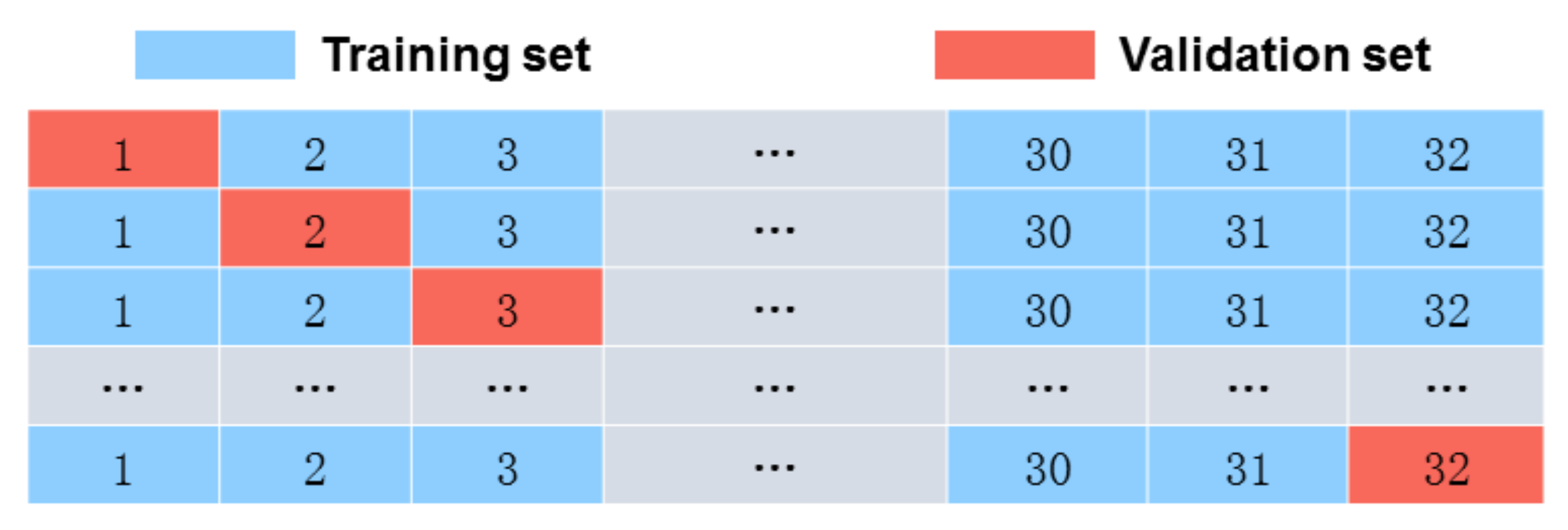
3.2.4. Verification of the Predicted Hypsographic Curve
4. Results and Analysis
4.1. Extraction of the Area and Water Level for Gahai Lake
4.1.1. Comparison of Gahai Lake Area Extracted from Landsat and MODIS
4.1.2. Satellite Altimetry Data for the Area of Gahai Lake
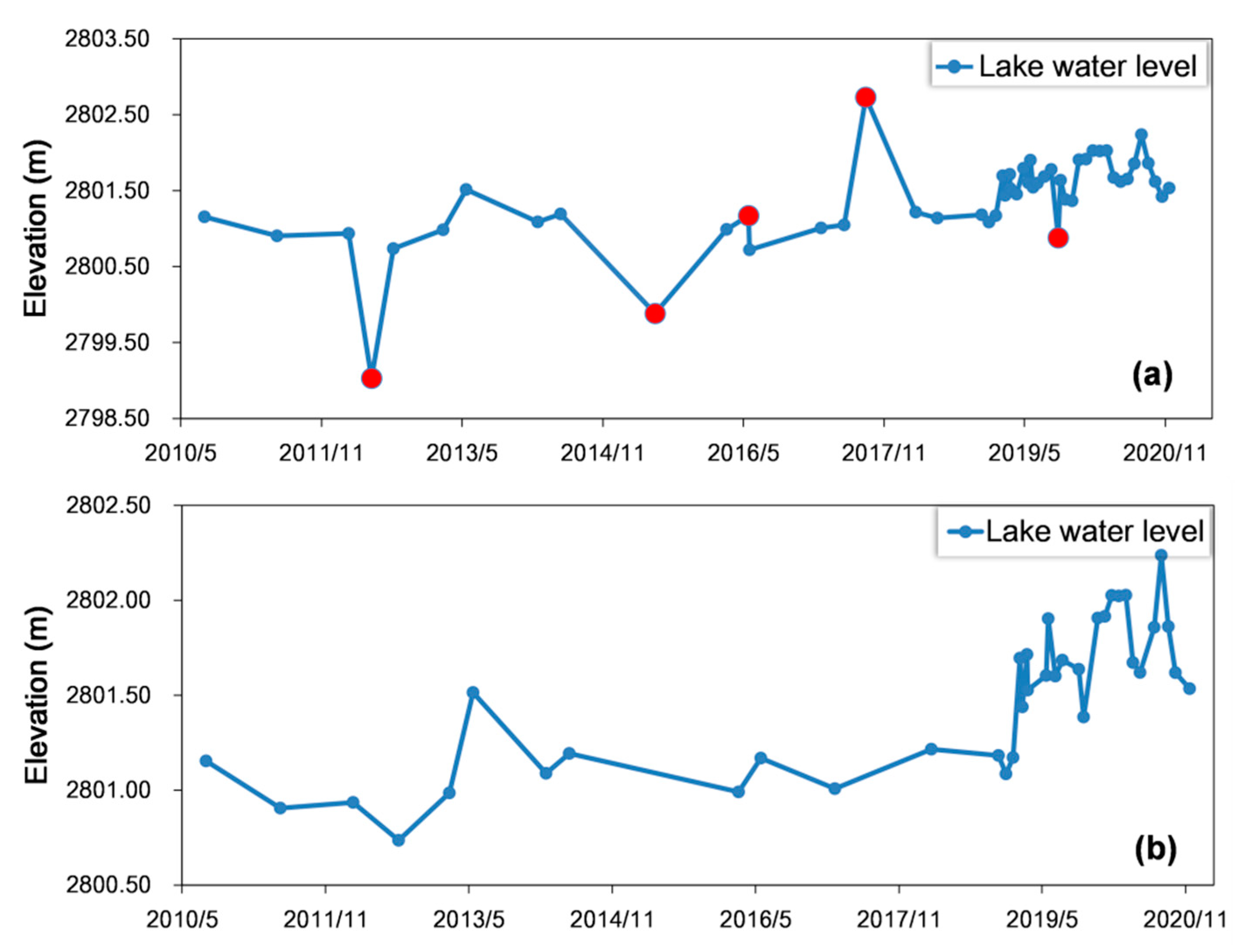
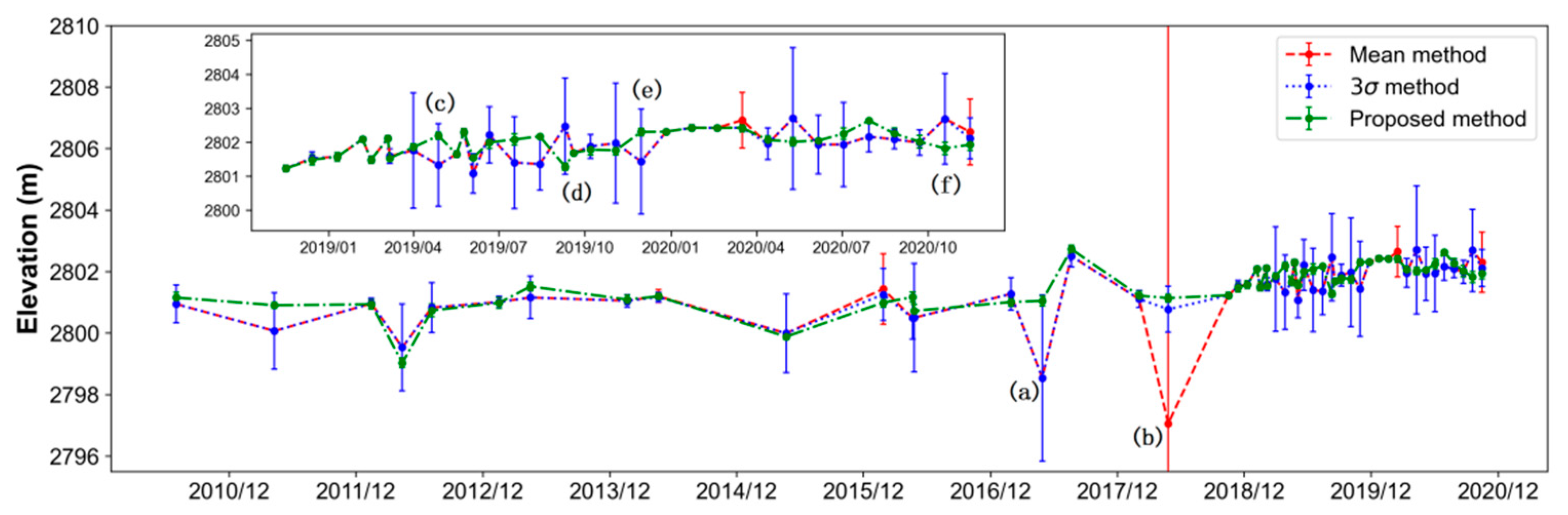
4.1.3. Extraction of Water Level of Gahai Lake
4.2. Hypsographic Curves for Gahai Lake
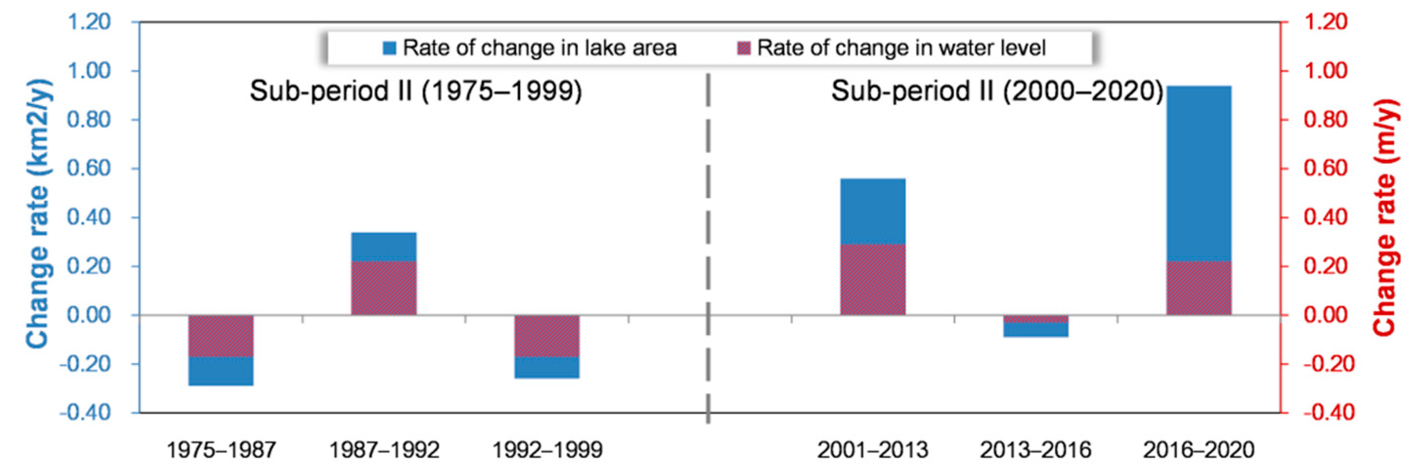
4.3. Variations in the Area, Water Level and Water Storage of Gahai Lake
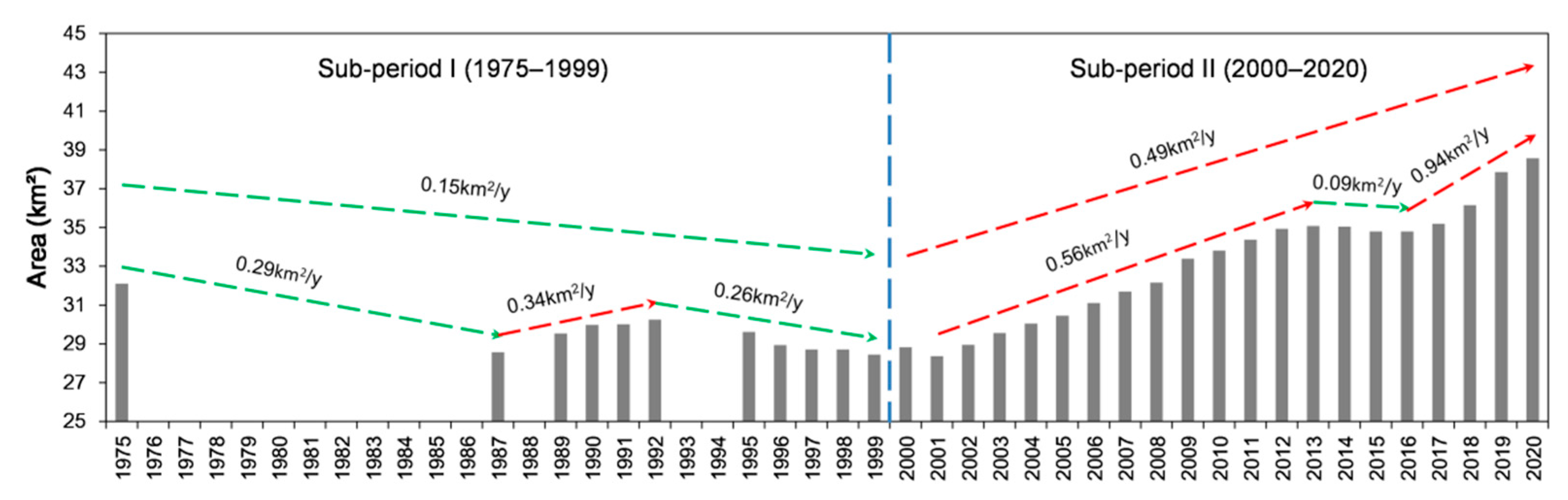
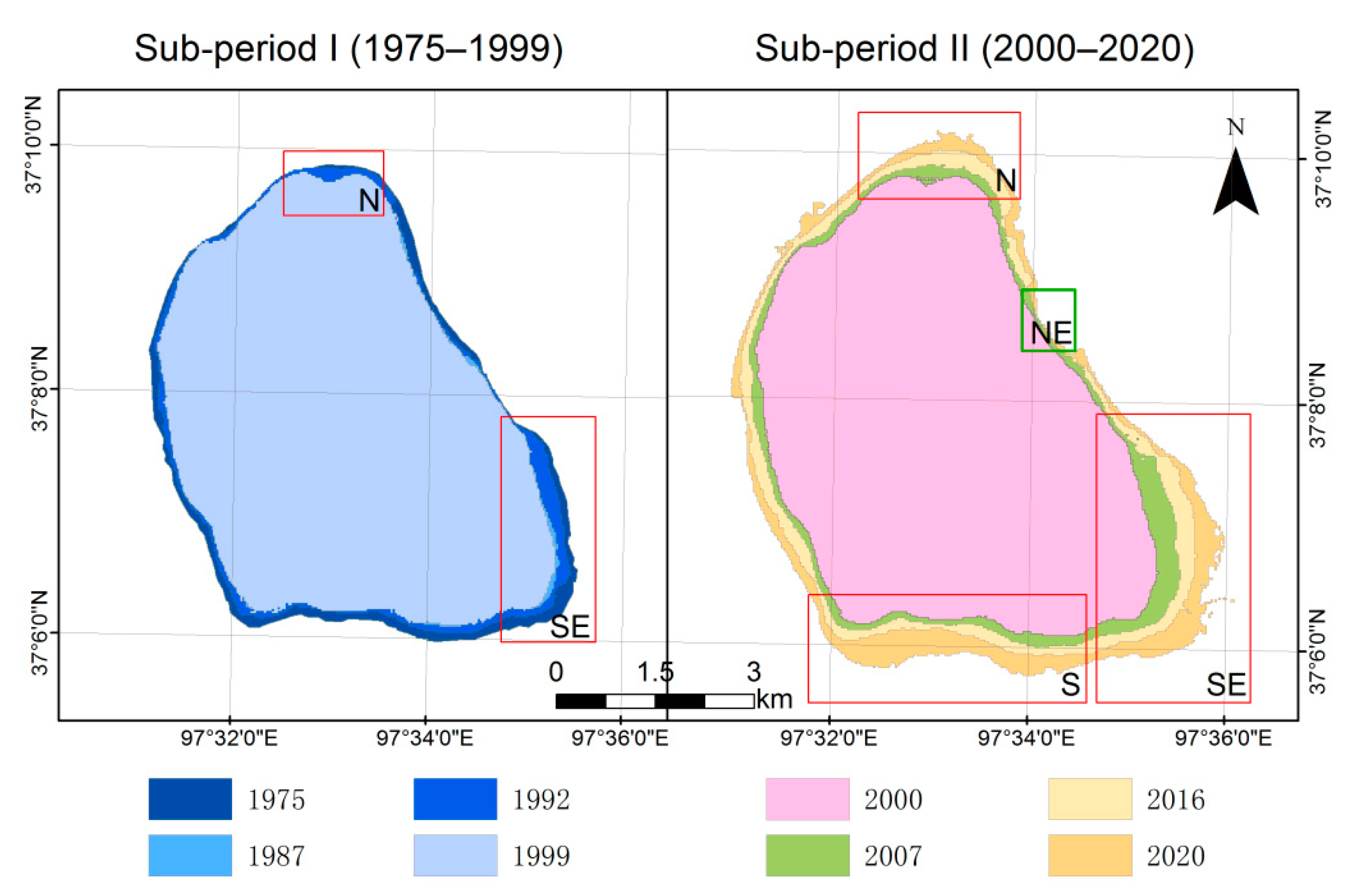
4.3.1. Variations in the Area of Gahai Lake
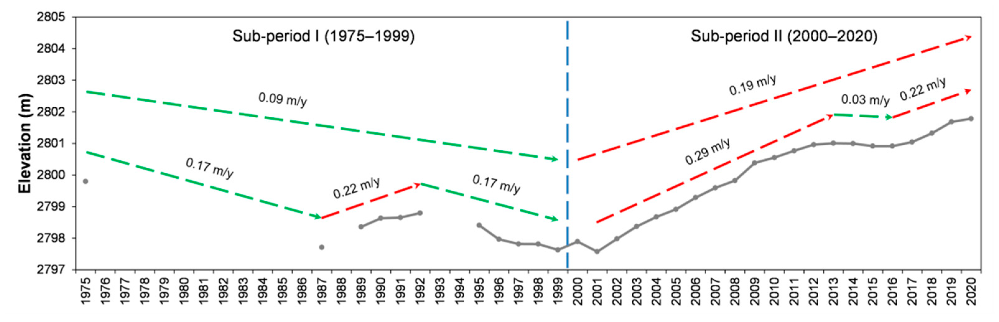
4.3.2. Variations in the Water Level of Gahai Lake
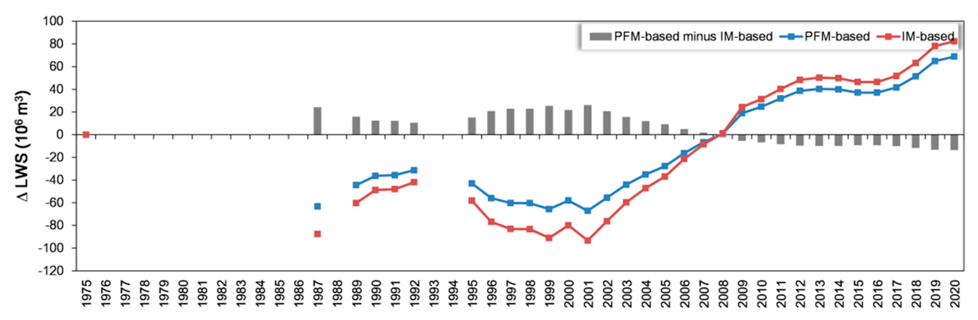
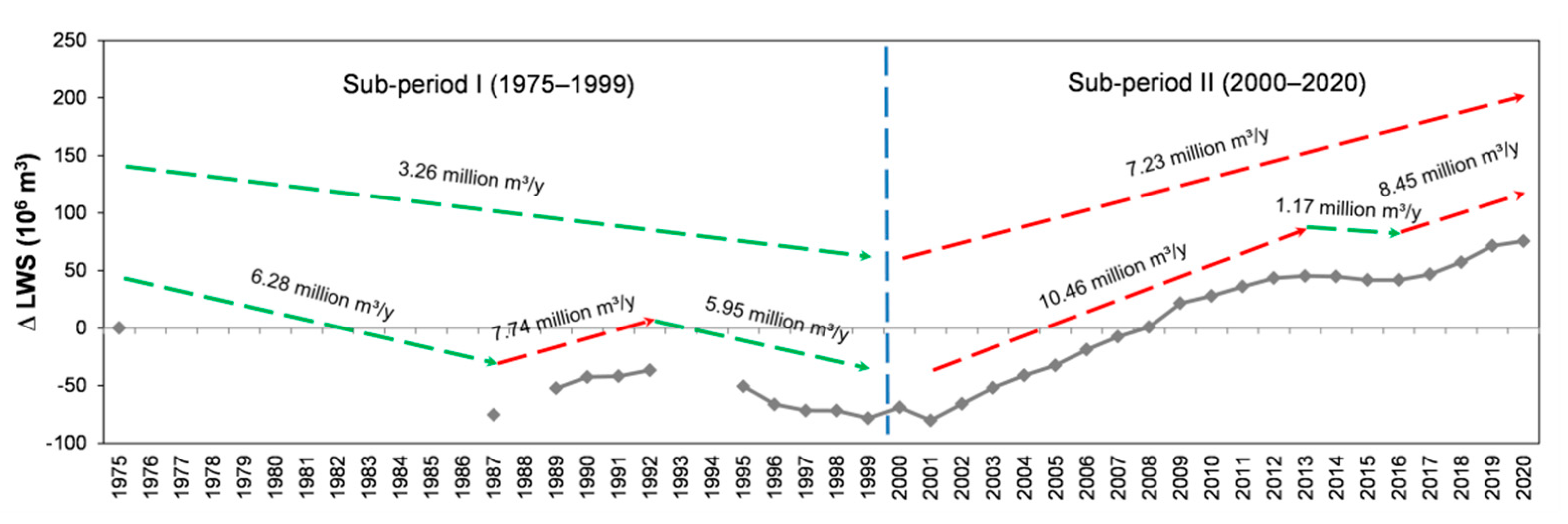
4.3.3. Variations in Water Storage of Gahai Lake
5. Discussion
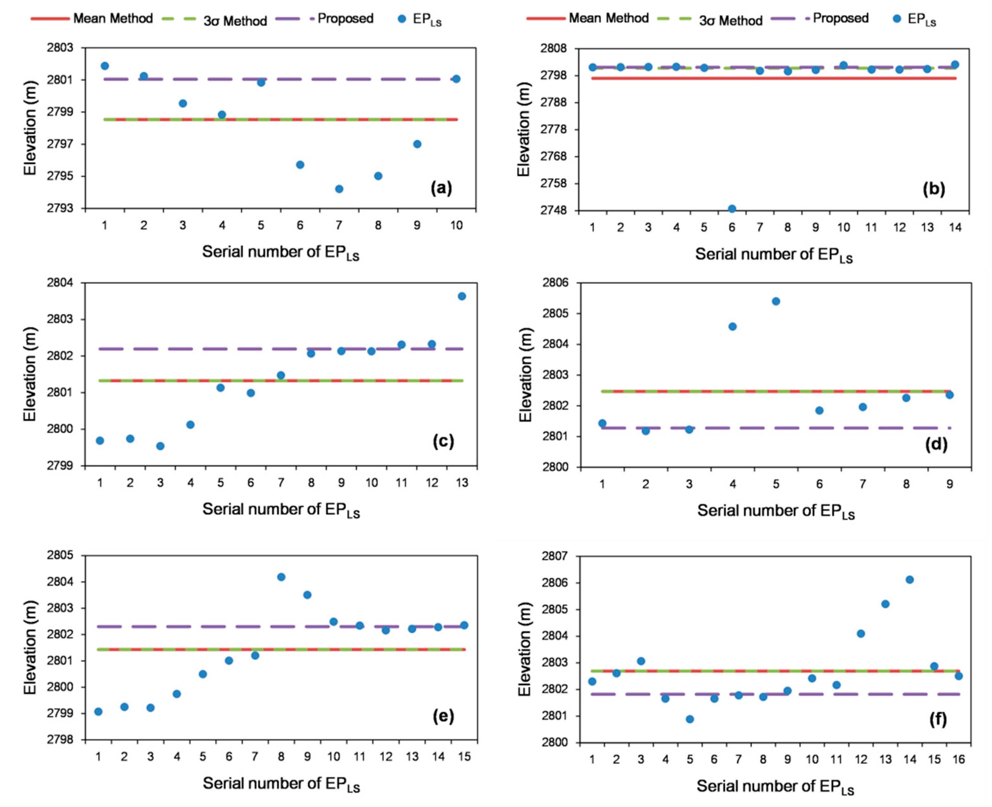
5.1. Rationalization for the Extraction of Water Level of the Lake
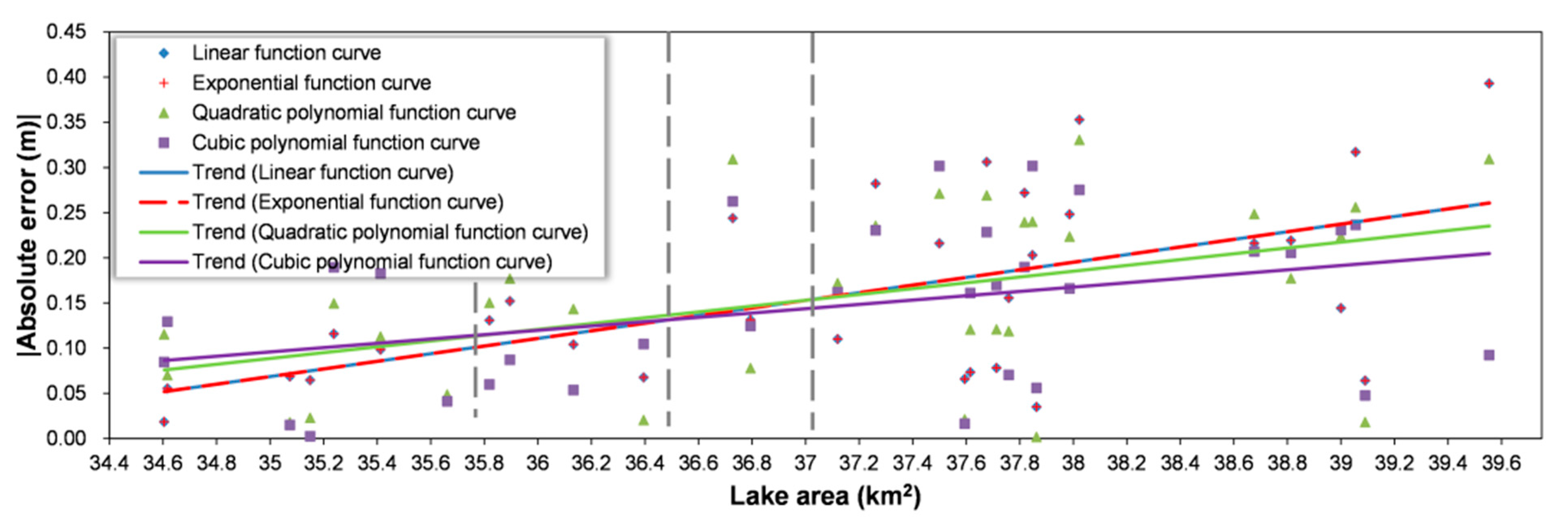
5.2. Validation of the Hypsographic Curve
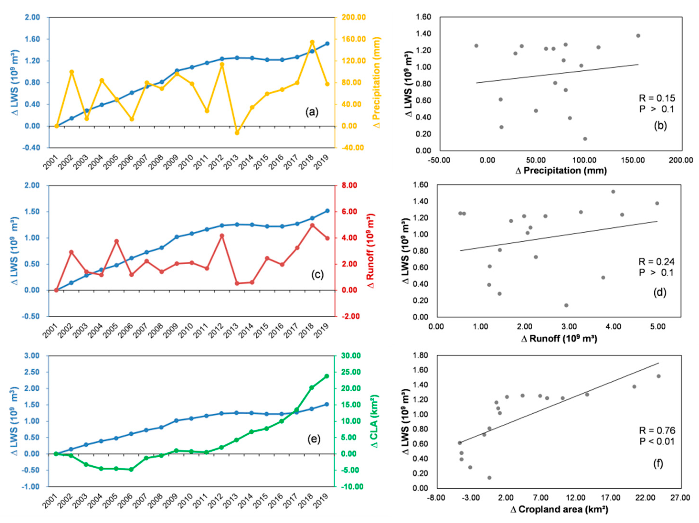
5.3. Discussion of Variations in Water Storage of Gahai Lake
6. Conclusions
Author Contributions
Funding
Acknowledgments
Conflicts of Interest
References
- Liu, B.; Wang, Y.; Xia, J.; Quan, J.; Wang, J. Optimal water resources operation for rivers-connected lake under uncertainty. J. Hydrol. 2021, 595, 125863. [Google Scholar] [CrossRef]
- Zhu, W.; Yan, J.; Jia, S. Monitoring recent fluctuations of the southern Pool of Lake Chad using multiple remote sensing data: Implications for water balance analysis. Remote Sens. 2017, 9, 1032. [Google Scholar] [CrossRef] [Green Version]
- Che, X.; Feng, M.; Sun, Q.; Sexton, J.O.; Channan, S.; Liu, J. The Decrease in Lake Numbers and Areas in Central Asia Investigated Using a Landsat-Derived Water Dataset. Remote Sens. 2021, 13, 1032. [Google Scholar] [CrossRef]
- Song, C.; Huang, B.; Ke, L.; Richards, K.S. Remote sensing of alpine lake water environment changes on the Tibetan Plateau and surroundings: A review. ISPRS J. Photogramm. Remote Sens. 2014, 92, 26–37. [Google Scholar] [CrossRef]
- Qiao, B.; Zhu, L.; Yang, R. Temporal-spatial differences in lake water storage changes and their links to climate change throughout the Tibetan Plateau. Remote Sens. Environ. 2019, 222, 232–243. [Google Scholar] [CrossRef]
- Qiao, B.; Zhu, L.; Wang, J.; Ju, J.; Ma, Q.; Huang, L.; Chen, H.; Liu, C.; Xu, T. Estimation of lake water storage and changes based on bathymetric data and altimetry data and the association with climate change in the central Tibetan Plateau. J. Hydrol. 2019, 578, 124052. [Google Scholar] [CrossRef]
- Zhang, G.; Chen, W.; Li, G.; Yang, W.; Yi, S.; Luo, W. Lake water and glacier mass gains in the northwestern Tibetan Plateau observed from multi-sensor remote sensing data: Implication of an enhanced hydrological cycle. Remote Sens. Environ. 2020, 237, 111554. [Google Scholar] [CrossRef]
- Jiao, J.J.; Zhang, X.; Liu, Y.; Kuang, X. Increased Water Storage in the Qaidam Basin, the North Tibet Plateau from GRACE Gravity Data. PLoS ONE 2015, 10, e0141442. [Google Scholar] [CrossRef] [Green Version]
- Jiao, K.; Gao, J.; Liu, Z. Precipitation Drives the NDVI Distribution on the Tibetan Plateau While High Warming Rates May Intensify Its Ecological Droughts. Remote Sens. 2021, 13, 1305. [Google Scholar] [CrossRef]
- Lv, A.; Zhou, L. A Rainfall Model Based on a Geographically Weighted Regression Algorithm for Rainfall Estimations over the Arid Qaidam Basin in China. Remote Sens. 2016, 8, 311. [Google Scholar] [CrossRef] [Green Version]
- Zhao, L.; Wang, X.; Ma, Y.; Li, S.; Wang, L. Investigation and assessment of ecological water resources in the salt marsh area of a salt lake: A case study of West Taijinar Lake in the Qaidam Basin, China. PLoS ONE 2021, 16, e0245993. [Google Scholar]
- Qi, S.; Lv, A. Applicability analysis of multiple precipitation products in the Qaidam Basin, Northwestern China. Environ. Sci. Pollut. Res. Int. 2021, 1–17. [Google Scholar] [CrossRef]
- Birkett, C.M. The contribution of TOPEX/POSEIDON to the global monitoring of climatically sensitive lakes. J. Geophys. Res. 1995, 100, 25179. [Google Scholar] [CrossRef]
- Li, S.; Chen, J.; Xiang, J.; Pan, Y.; Huang, Z.; Wu, Y. Water level changes of Hulun Lake in Inner Mongolia derived from Jason satellite data. J. Vis. Commun. Image Represent. 2019, 58, 565–575. [Google Scholar] [CrossRef]
- Jiang, L.; Nielsen, K.; Andersen, O.B.; Bauer-Gottwein, P. Monitoring recent lake level variations on the Tibetan Plateau using CryoSat-2 SARIn mode data. J. Hydrol. 2017, 544, 109–124. [Google Scholar] [CrossRef] [Green Version]
- Xu, X.; Yuan, L.; Jiang, Z.; Chen, C.; Cheng, S. Lake level changes determined by Cryosat-2 altimetry data and water-induced loading deformation around Lake Qinghai. Adv. Space Res. 2020, 66, 2568–2582. [Google Scholar] [CrossRef]
- Liao, J.; Liao, J.; Shen, G.; Zhao, Y.; Zhao, Y. Dataset of Global Lake Level Changes Using Multi-altimeter Data (2002-2016). J. Glob. Chang. Data Discov. 2018, 2, 295–302. [Google Scholar] [CrossRef]
- Wen, J.; Zhao, H.; Jiang, Y.; Chen, D.; Ji, G. Research on the quality screening method for satellite altimetry data—Take Jason-3 data and Hongze Lake as an example. South North Water Transf. Water Sci. Technol. 2018, 16, 194–200+208. [Google Scholar] [CrossRef]
- Feng, L.; Hu, C.; Chen, X.; Cai, X.; Tian, L.; Gan, W. Assessment of inundation changes of Poyang Lake using MODIS observations between 2000 and 2010. Remote Sens. Environ. 2012, 121, 80–92. [Google Scholar] [CrossRef]
- McCullough, I.M.; Loftin, C.S.; Sader, S.A. High-frequency remote monitoring of large lakes with MODIS 500m imagery. Remote Sens. Environ. 2012, 124, 234–241. [Google Scholar] [CrossRef]
- Pekel, J.F.; Cottam, A.; Gorelick, N.; Belward, A.S. High-resolution mapping of global surface water and its long-term changes. Nature 2016, 540, 418–422. [Google Scholar] [CrossRef]
- Wang, J.; Sheng, Y.; Tong, T.S.D. Monitoring decadal lake dynamics across the Yangtze Basin downstream of Three Gorges Dam. Remote Sens. Environ. 2014, 152, 251–269. [Google Scholar] [CrossRef]
- Zhang, B.; Wu, Y.; Zhu, L.; Wang, J.; Li, J.; Chen, D. Estimation and trend detection of water storage at Nam Co Lake, central Tibetan Plateau. J. Hydrol. 2011, 405, 161–170. [Google Scholar] [CrossRef]
- Seyoum, W.M. Characterizing water storage trends and regional climate influence using GRACE observation and satellite altimetry data in the Upper Blue Nile River Basin. J. Hydrol. 2018, 566, 274–284. [Google Scholar] [CrossRef]
- Schwatke, C.; Dettmering, D.; Seitz, F. Volume Variations of Small Inland Water Bodies from a Combination of Satellite Altimetry and Optical Imagery. Remote Sens. 2020, 12, 1606. [Google Scholar] [CrossRef]
- Wang, L.; Kaban, M.K.; Thomas, M.; Chen, C.; Ma, X. The Challenge of Spatial Resolutions for GRACE-Based Estimates Volume Changes of Larger Man-Made Lake: The Case of China’s Three Gorges Reservoir in the Yangtze River. Remote Sens. 2019, 11, 99. [Google Scholar] [CrossRef] [Green Version]
- Liu, Y.; Yue, H. Estimating the fluctuation of Lake Hulun, China, during 1975-2015 from satellite altimetry data. Environ. Monit. Assess. 2017, 189, 630. [Google Scholar] [CrossRef] [PubMed]
- Baup, F.; Frappart, F.; Maubant, J. Combining high-resolution satellite images and altimetry to estimate the volume of small lakes. Hydrol. Earth Syst. Sci. 2014, 18, 2007–2020. [Google Scholar] [CrossRef] [Green Version]
- Abileah, R.; Vignudelli, S.; Scozzari, A. A completely remote sensing approach to monitoring reservoirs water volume. Int. Water Technol. J. 2011, 1, 59–72. [Google Scholar]
- Busker, T.; de Roo, A.; Gelati, E.; Schwatke, C.; Adamovic, M.; Bisselink, B.; Pekel, J.-F.; Cottam, A. A global lake and reservoir volume analysis using a surface water dataset and satellite altimetry. Hydrol. Earth Syst. Sci. 2019, 23, 669–690. [Google Scholar] [CrossRef] [Green Version]
- Chen, T.; Song, C.; Ke, L.; Wang, J.; Liu, K.; Wu, Q. Estimating seasonal water budgets in global lakes by using multi-source remote sensing measurements. J. Hydrol. 2021, 593, 125781. [Google Scholar] [CrossRef]
- Xu, Y.; Li, J.; Wang, J.; Chen, J.; Liu, Y.; Ni, S.; Zhang, Z.; Ke, C. Assessing water storage changes of Lake Poyang from multi-mission satellite data and hydrological models. J. Hydrol. 2020, 590, 125229. [Google Scholar] [CrossRef]
- Yao, F.; Wang, J.; Yang, K.; Wang, C.; Walter, B.A.; Crétaux, J.-F. Lake storage variation on the endorheic Tibetan Plateau and its attribution to climate change since the new millennium. Environ. Res. Lett. 2018, 13, 064011. [Google Scholar] [CrossRef]
- Lin, Y.; Li, X.; Zhang, T.; Chao, N.; Yu, J.; Cai, J.; Sneeuw, N. Water Volume Variations Estimation and Analysis Using Multisource Satellite Data: A Case Study of Lake Victoria. Remote Sens. 2020, 12, 3052. [Google Scholar] [CrossRef]
- Dettmering, D.; Ellenbeck, L.; Scherer, D.; Schwatke, C.; Niemann, C. Potential and Limitations of Satellite Altimetry Constellations for Monitoring Surface Water Storage Changes—A Case Study in the Mississippi Basin. Remote Sens. 2020, 12, 3320. [Google Scholar] [CrossRef]
- Yao, F.; Wang, J.; Wang, C.; Crétaux, J.-F. Constructing long-term high-frequency time series of global lake and reservoir areas using Landsat imagery. Remote Sens. Environ. 2019, 232, 111210. [Google Scholar] [CrossRef]
- Håkanson, L. On Lake Form, Lake Volume and Lake Hypsographic Survey. Geogr. Annaler. Ser. A Phys. Geogr. 1977, 59, 1–30. [Google Scholar] [CrossRef]
- Huang, J.; Tao, H.; Wang, Y.; Bai, y. Analysis on relationship between water level and water area of lake based on MODIS image. Trans. Chin. Soc. Agric. Eng. 2012, 28, 140–146. [Google Scholar] [CrossRef]
- Wang, J.; Yang, S.; Liu, H.; Wang, P.; Lou, H.; Gong, T. Simulation of Lake Water Volume in Ungauged Terminal Lake Basin Based on Multi-Source Remote Sensing. Remote Sens. 2021, 13, 697. [Google Scholar] [CrossRef]
- Chaudhari, S.; Felfelani, F.; Shin, S.; Pokhrel, Y. Climate and anthropogenic contributions to the desiccation of the second largest saline lake in the twentieth century. J. Hydrol. 2018, 560, 342–353. [Google Scholar] [CrossRef]
- Gou, Z.; Liu, F. Gahai Lake, Qinghai-Tibet Plateau(Delingha), China. J. Glob. Chang. Data Discov. 2018, 2, 456–457. [Google Scholar] [CrossRef]
- Zhang, G.; Li, J.; Zheng, G. Lake-area mapping in the Tibetan Plateau: An evaluation of data and methods. Int. J. Remote Sens. 2016, 38, 742–772. [Google Scholar] [CrossRef]
- Xu, R.; Tian, F.; Yang, L.; Hu, H.; Lu, H.; Hou, A. Ground validation of GPM IMERG and TRMM 3B42V7 rainfall products over southern Tibetan Plateau based on a high-density rain gauge network. J. Geophys. Res. Atmos. 2017, 122, 910–924. [Google Scholar] [CrossRef]
- Jurík, Ľ.; Halászová, K.; Pokrývková, J.; Rehák, Š. Irrigation of Arable Land in Slovakia: History and Perspective. In Water Resources in Slovakia: Part I: Assessment and Development; Negm, A.M., Zeleňáková, M., Eds.; Springer International Publishing: Cham, Switzerland, 2019; pp. 81–96. [Google Scholar]
- Liang, D.; Zuo, Y.; Huang, L.; Zhao, J.; Teng, L.; Yang, F. Evaluation of the Consistency of MODIS Land Cover Product (MCD12Q1) Based on Chinese 30 m GlobeLand30 Datasets: A Case Study in Anhui Province, China. ISPRS Int. J. Geo-Inf. 2015, 4, 2519–2541. [Google Scholar] [CrossRef] [Green Version]
- Chen, J.; Zhu, X.; Vogelmann, J.E.; Gao, F.; Jin, S. A simple and effective method for filling gaps in Landsat ETM+ SLC-off images. Remote Sens. Environ. 2011, 115, 1053–1064. [Google Scholar] [CrossRef]
- Mahajan, S.; Martinez, J. Water, water, but not everywhere: Analysis of shrinking water bodies using open access satellite data. Int. J. Sustain. Dev. World Ecol. 2020, 28, 326–338. [Google Scholar] [CrossRef]
- Gu, Z.; Zhang, Y.; Fan, H. Mapping inter- and intra-annual dynamics in water surface area of the Tonle Sap Lake with Landsat time-series and water level data. J. Hydrol. 2021, 601, 126644. [Google Scholar] [CrossRef]
- Gao, B.-C. NDWI—A normalized difference water index for remote sensing of vegetation liquid water from space. Remote Sens. Environ. 1996, 58, 257–266. [Google Scholar] [CrossRef]
- Nielsen, K.; Stenseng, L.; Andersen, O.B.; Villadsen, H.; Knudsen, P. Validation of CryoSat-2 SAR mode based lake levels. Remote Sens. Environ. 2015, 171, 162–170. [Google Scholar] [CrossRef] [Green Version]
- Markus, T.; Neumann, T.; Martino, A.; Abdalati, W.; Brunt, K.; Csatho, B.; Farrell, S.; Fricker, H.; Gardner, A.; Harding, D.; et al. The Ice, Cloud, and land Elevation Satellite-2 (ICESat-2): Science requirements, concept, and implementation. Remote Sens. Environ. 2017, 190, 260–273. [Google Scholar] [CrossRef]
- Donlon, C.; Berruti, B.; Buongiorno, A.; Ferreira, M.H.; Féménias, P.; Frerick, J.; Goryl, P.; Klein, U.; Laur, H.; Mavrocordatos, C.; et al. The Global Monitoring for Environment and Security (GMES) Sentinel-3 mission. Remote Sens. Environ. 2012, 120, 37–57. [Google Scholar] [CrossRef]
- Li, Y.; Gao, H.; Zhao, G.; Tseng, K.-H. A high-resolution bathymetry dataset for global reservoirs using multi-source satellite imagery and altimetry. Remote Sens. Environ. 2020, 244, 111831. [Google Scholar] [CrossRef]
- Shao, J. Linear Model Selection by Cross-validation. J. Am. Stat. Assoc. 1993, 88, 486–494. [Google Scholar] [CrossRef]
- Hawkins, D.M.; Basak, S.C.; Mills, D. Assessing model fit by cross-validation. J. Chem. Inf. Comput. Sci. 2003, 43, 579–586. [Google Scholar] [CrossRef] [PubMed]
- Vehtari, A.; Gelman, A.; Gabry, J. Practical Bayesian model evaluation using leave-one-out cross-validation and WAIC. Stat. Comput. 2016, 27, 1413–1432. [Google Scholar] [CrossRef] [Green Version]
- Chipman, J. A Multisensor Approach to Satellite Monitoring of Trends in Lake Area, Water Level, and Volume. Remote Sens. 2019, 11, 158. [Google Scholar] [CrossRef] [Green Version]
- Crétaux, J.F.; Arsen, A.; Calmant, S.; Kouraev, A.; Vuglinski, V.; Bergé-Nguyen, M.; Gennero, M.C.; Nino, F.; Abarca Del Rio, R.; Cazenave, A.; et al. SOLS: A lake database to monitor in the Near Real Time water level and storage variations from remote sensing data. Adv. Space Res. 2011, 47, 1497–1507. [Google Scholar] [CrossRef]
- Schwatke, C.; Dettmering, D.; Bosch, W.; Seitz, F. DAHITI—An innovative approach for estimating water level time series over inland waters using multi-mission satellite altimetry. Hydrol. Earth Syst. Sci. 2015, 19, 4345–4364. [Google Scholar] [CrossRef] [Green Version]
- Birkett, C.; Reynolds, C.; Beckley, B.; Doorn, B. From research to operations: The USDA global reservoir and lake monitor. In Coastal Altimetry; Springer: Berlin/Heidelberg, Germany, 2011; pp. 19–50. [Google Scholar]
- Xu, N.; Ma, Y.; Zhang, W.; Wang, X.H.; Yang, F.; Su, D. Monitoring Annual Changes of Lake Water Levels and Volumes over 1984–2018 Using Landsat Imagery and ICESat-2 Data. Remote Sens. 2020, 12, 4004. [Google Scholar] [CrossRef]
- Biancamaria, S.; Lettenmaier, D.P.; Pavelsky, T.M. The SWOT mission and its capabilities for land hydrology. Surv. Geophys. 2016, 37, 307–337. [Google Scholar] [CrossRef] [Green Version]


| Application | Data | Time Span | Resolution | |
|---|---|---|---|---|
| Spatial Resolution (m) | Temporal Resolution (Day) | |||
| To build the hypsographic curve | Landsat ETM/OIL GF/ZY | 2010–2020 | 30 | 16 |
| 2/6 | ||||
| CryoSat-2 ICESat-2 Sentinel-3B | - | 30 | ||
| 91 | ||||
| 27 | ||||
| To analyze annual lake area variation | Landsat TM/ETM/OIL | 1987–2020 | 30 | 16 |
| Digital map | 1975 | - | - | |
| Data | Longitude | Latitude | Collection Time | |
|---|---|---|---|---|
| CryoSat-2 | Lon_poca_20_ku | Lat_poca_20_ku | Time_20_ku | Height_1_20_ku |
| ICESat-2 | Sseg_mean_lon | Sseg_mean_lat | Sseg_mean_time | Ht_water_surf |
| Sentinel-3 | Lon_cor_20_ku | Lat_cor_20_ku | Time_20_ku | Sea_ice_sea_surf_20_ku |
| Algorithm to Extract Elevation Points |
|---|
| Begin (1) Enter the EPLS {p1, p2, pi} for the lake elevation point of a certain period. (2) Take point p1 as the benchmark; if the other elevation points pi satisfy p1 − 0.3 < pi < p1 + 0.3 (units of m), put point pi into container List-1. Loop through all elevation points to get all containers (List-1, List-2, …, List-i) and the stored point set. (3) Count the length of the containers. The set of points in the longest container is the effective elevation point (EEPLS) set. If two or more containers have the same length, find the standard deviation of the point set for each container and take the point set with the smallest standard deviation as the effective elevation point set for the lake. (4) Calculate the average by EEPLS and output the final water level of the lake. End |
| Period | N_EPLS | N_EEPLS | ER | Period | N_EPLS | N_EEPLS | ER |
|---|---|---|---|---|---|---|---|
| 2012/05/13 | 18.00 | 5.00 | 27.78% | 2019/04/28 | 13.00 | 5.00 | 38.46% |
| 2015/05/23 | 10.00 | 3.00 | 30.00% | 2019/06/04 | 4.00 | 2.00 | 50.005% |
| 2016/05/25 | 20.00 | 7.00 | 35.00% | 2019/08/14 | 12.00 | 4.00 | 33.33% |
| 2017/05/29 | 10.00 | 3.00 | 30.00% | 2019/09/10 | 9.00 | 3.00 | 33.33% |
| 2017/08/21 | 6.00 | 4.00 | 66.67% | 2019/11/03 | 18.00 | 7.00 | 38.89% |
| 2018/05/27 | 14.00 | 5.00 | 35.71% | 2020/06/06 | 12.00 | 4.00 | 33.33% |
| 2019/04/01 | 15.00 | 5.00 | 33.33% | 2020/10/19 | 16.00 | 6.00 | 37.50% |
Publisher’s Note: MDPI stays neutral with regard to jurisdictional claims in published maps and institutional affiliations. |
© 2021 by the authors. Licensee MDPI, Basel, Switzerland. This article is an open access article distributed under the terms and conditions of the Creative Commons Attribution (CC BY) license (https://creativecommons.org/licenses/by/4.0/).
Share and Cite
Zhang, C.; Lv, A.; Zhu, W.; Yao, G.; Qi, S. Using Multisource Satellite Data to Investigate Lake Area, Water Level, and Water Storage Changes of Terminal Lakes in Ungauged Regions. Remote Sens. 2021, 13, 3221. https://doi.org/10.3390/rs13163221
Zhang C, Lv A, Zhu W, Yao G, Qi S. Using Multisource Satellite Data to Investigate Lake Area, Water Level, and Water Storage Changes of Terminal Lakes in Ungauged Regions. Remote Sensing. 2021; 13(16):3221. https://doi.org/10.3390/rs13163221
Chicago/Turabian StyleZhang, Chuanhui, Aifeng Lv, Wenbin Zhu, Guobiao Yao, and Shanshan Qi. 2021. "Using Multisource Satellite Data to Investigate Lake Area, Water Level, and Water Storage Changes of Terminal Lakes in Ungauged Regions" Remote Sensing 13, no. 16: 3221. https://doi.org/10.3390/rs13163221
APA StyleZhang, C., Lv, A., Zhu, W., Yao, G., & Qi, S. (2021). Using Multisource Satellite Data to Investigate Lake Area, Water Level, and Water Storage Changes of Terminal Lakes in Ungauged Regions. Remote Sensing, 13(16), 3221. https://doi.org/10.3390/rs13163221