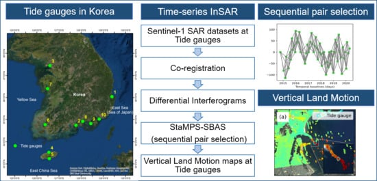
Monitoring the Vertical Land Motion of Tide Gauges and Its Impact on Relative Sea Level Changes in Korean Peninsula Using Sequential SBAS-InSAR Time-Series Analysis
Abstract
1. Introduction
2. Study Area and Data Used
2.1. Interferometric SAR Data
2.2. Tide Gauge and GPS Data
3. Methods
3.1. Sequential Pair Selection
3.1.1. Experimental Results
3.2. Experimental Setup
3.3. Vertical Land Motion
4. Results
4.1. Vertical Land Motion at Tide Gauges in the Korean Peninsula
4.1.1. Pohang Tide Gauge
4.1.2. Yeosu Tide Gauge
4.1.3. Incheon Tide Gauge
4.1.4. Jeju and Seogwipo Tide Gauges
5. Discussion
Vertical Land Motion
6. Conclusions
Supplementary Materials
Author Contributions
Funding
Acknowledgments
Conflicts of Interest
References
- Kulp, S.A.; Strauss, B.H. New elevation data triple estimates of global vulnerability to sea-level rise and coastal flooding. Nat. Commun. 2019, 10, 4844. [Google Scholar] [CrossRef] [PubMed]
- Jackson, L.P.; Jevrejeva, S. A probabilistic approach to 21st century regional sea-level projections using RCP and High-end scenarios. Glob. Planet. Chang. 2016, 146, 179–189. [Google Scholar] [CrossRef]
- Clark, P.U.; Shakun, J.D.; Marcott, S.A.; Mix, A.C.; Eby, M.; Kulp, S.; Levermann, A.; Milne, G.A.; Pfister, P.L.; Santer, B.D.; et al. Consequences of twenty-first-century policy for multi-millennial climate and sea-level change. Nat. Clim. Chang. 2016, 6, 360. [Google Scholar] [CrossRef]
- Hallegatte, S.; Green, C.; Nicholls, R.J.; Corfee-Morlot, J. Future flood losses in major coastal cities. Nat. Clim. Chang. 2013, 3, 802–806. [Google Scholar] [CrossRef]
- Holgate, S.J.; Matthews, A.; Woodworth, P.L.; Rickards, L.J.; Tamisiea, M.E.; Bradshaw, E.; Foden, P.R.; Gordon, K.M.; Jevrejeva, S.; Pugh, J. New Data Systems and Products at the Permanent Service for Mean Sea Level. J. Coast. Res. 2013, 29, 493–504. [Google Scholar]
- Church, J.A.; Clark, P.U.; Cazenave, A.; Gregory, J.M.; Jevrejeva, S.; Levermann, A.; Merrifield, M.A.; Milne, G.A.; Nerem, R.S.; Nunn, P.D.; et al. Sea-level rise by 2100. Science 2013, 342, 1445. [Google Scholar] [CrossRef]
- Cazenave, A.; Palanisamy, H.; Ablain, M. Contemporary sea level changes from satellite altimetry: What have we learned? What are the new challenges? Adv. Space Res. 2018, 62, 1639–1653. [Google Scholar] [CrossRef]
- Nerem, R.S.; Beckley, B.D.; Fasullo, J.T.; Hamlington, B.D.; Masters, D.; Mitchum, G.T. Climate-change–driven accelerated sea-level rise detected in the altimeter era. Proc. Natl. Acad. Sci. USA 2018, 115, 2022–2025. [Google Scholar] [CrossRef]
- Church, J.A.; White, N.J. Sea-level rise from the late 19th to the early 21st century. Surv. Geophys. 2011, 32, 585–602. [Google Scholar] [CrossRef]
- Peltier, W.R.; Tushingham, A.M. Influence of glacial isostatic adjustment on tide gauge measurements of secular sea level change. J. Geophys. Res. Solid Earth 1991, 96, 6779–6796. [Google Scholar] [CrossRef]
- Jevrejeva, S.; Moore, J.C.; Grinsted, A.; Woodworth, P.L. Recent global sea level acceleration started over 200 years ago? Geophys. Res. Lett. 2008, 35, L08715. [Google Scholar] [CrossRef]
- Cazenave, A.; Le Cozannet, G.; Benveniste, J.; Woodworth, P.; Champollion, N. Monitoring coastal zone changes from space. Eos 2017, 98. [Google Scholar] [CrossRef]
- Wöppelmann, G.; Marcos, M. Vertical land motion as a key to understanding sea level change and variability. Rev. Geophys. 2016, 54, 64–92. [Google Scholar] [CrossRef]
- Poitevin, C.; Wöppelmann, G.; Raucoules, D.; Le Cozannet, G.; Marcos, M.; Testut, L. Vertical land motion and relative sea level changes along the coastline of Brest (France) from combined space-borne geodetic methods. Remote Sens. Environ. 2019, 222, 275–285. [Google Scholar] [CrossRef]
- Santamaría-Gómez, A.; Gravelle, M.; Wöppelmann, G. Long-term vertical land motion from double-differenced tide gauge and satellite altimetry data. J. Geod. 2014, 88, 207–222. [Google Scholar] [CrossRef]
- Blewitt, G.; Altamimi, Z.; Davis, J.; Gross, R.; Kuo, C.-Y.; Lemoine, F.G.; Moore, A.W.; Neilan, R.E.; Plag, H.-P.; Rothacher, M.; et al. Geodetic observations and global reference frame contributions to understanding sea-level rise and variability. Underst. Sea Level Rise Var. 2010, 256–284. [Google Scholar]
- Schöne, T.; Schön, N.; Thaller, D. IGS Tide Gauge Benchmark Monitoring Pilot Project (TIGA): Scientific benefits. J. Geod. 2009, 83, 249–261. [Google Scholar] [CrossRef]
- Benveniste, J.; Cazenave, A.; Vignudelli, S.; Fenoglio-Marc, L.; Shah, R.; Almar, R.; Andersen, O.; Birol, F.; Bonnefond, P.; Bouffard, J.; et al. Requirements for a coastal hazards observing system. Front. Mar. Sci. 2019, 6, 348. [Google Scholar] [CrossRef]
- Palanisamy Vadivel, S.K.; Kim, D.-j.; Jung, J.; Cho, Y.-K.; Han, K.-J.; Jeong, K.-Y. Sinking Tide Gauge revealed by space-borne insar: Implications for sea level acceleration at Pohang, South Korea. Remote Sens. 2019, 11, 277. [Google Scholar] [CrossRef]
- Wöppelmann, G.; Le Cozannet, G.; Michele, M.; Raucoules, D.; Cazenave, A.; Garcin, M.; Hanson, S.; Marcos, M.; Santamaría-Gómez, A. Is land subsidence increasing the exposure to sea level rise in Alexandria, Egypt? Geophys. Res. Lett. 2013, 40, 2953–2957. [Google Scholar] [CrossRef]
- Bekaert, D.P.S.; Hamlington, B.D.; Buzzanga, B.; Jones, C.E. spaceborne synthetic aperture radar survey of subsidence in hampton roads, Virginia (USA). Sci. Rep. 2017, 7, 14752. [Google Scholar] [CrossRef] [PubMed]
- Bekaert, D.P.S.; Jones, C.E.; An, K.; Huang, M.-H. Exploiting UAVSAR for a comprehensive analysis of subsidence in the Sacramento Delta. Remote Sens. Environ. 2019, 220, 124–134. [Google Scholar] [CrossRef]
- Morishita, Y.; Hanssen, R.F. Temporal decorrelation in L-, C-, and X-band satellite radar interferometry for pasture on drained peat soils. IEEE Trans. Geosci. Remote Sens. 2015, 53, 1096–1104. [Google Scholar] [CrossRef]
- Hooper, A.; Zebker, H.; Segall, P.; Kampes, B. A new method for measuring deformation on volcanoes and other natural terrains using InSAR persistent scatterers. Geophys. Res. Lett. 2004, 31, L23611. [Google Scholar] [CrossRef]
- Ferretti, A.; Prati, C.; Rocca, F. Permanent scatterers in SAR interferometry. IEEE Trans. Geosci. Remote Sens. 2001, 39, 8–20. [Google Scholar] [CrossRef]
- Berardino, P.; Fornaro, G.; Lanari, R.; Sansosti, E. A new algorithm for surface deformation monitoring based on small baseline differential SAR interferograms. IEEE Trans. Geosci. Remote Sens. 2002, 40, 2375–2383. [Google Scholar] [CrossRef]
- Hooper, A. A multi-temporal InSAR method incorporating both persistent scatterer and small baseline approaches. Geophys. Res. Lett. 2008, 35, L16302. [Google Scholar] [CrossRef]
- Ferretti, A.; Fumagalli, A.; Novali, F.; Prati, C.; Rocca, F.; Rucci, A. A new algorithm for processing interferometric data-stacks: SqueeSAR. IEEE Trans. Geosci. Remote Sens. 2011, 49, 3460–3470. [Google Scholar] [CrossRef]
- Ansari, H.; Zan, F.D.; Bamler, R. Sequential estimator: Toward efficient InSAR time series analysis. IEEE Trans. Geosci. Remote Sens. 2017, 55, 5637–5652. [Google Scholar] [CrossRef]
- Wang, B.; Zhao, C.; Zhang, Q.; Lu, Z.; Li, Z.; Liu, Y. Sequential estimation of dynamic deformation parameters for SBAS-InSAR. IEEE Geosci. Remote Sens. Lett. 2020, 17, 1017–1021. [Google Scholar] [CrossRef]
- Costantini, M.; Ferretti, A.; Minati, F.; Falco, S.; Trillo, F.; Colombo, D.; Novali, F.; Malvarosa, F.; Mammone, C.; Vecchioli, F.; et al. Analysis of surface deformations over the whole Italian territory by interferometric processing of ERS, Envisat and COSMO-SkyMed radar data. Remote Sens. Environ. 2017, 202, 250–275. [Google Scholar] [CrossRef]
- Yoon, J.-J. Analysis of long-period sea-level variation around the Korean Peninsula. J. Coast. Res. 2016, 75, 1432–1436. [Google Scholar] [CrossRef]
- Korea Hydrographic and Oceanographic Agency Korea Ocean Observing and Forecasting System. Available online: http://www.khoa.go.kr/oceangrid/khoa/koofs.do (accessed on 1 November 2019).
- Lim, C.; Park, S.-H.; Kim, D.-Y.; Woo, S.-B.; Jeong, K.-Y. Influence of Steric Effect on the Rapid Sea Level Rise at Jeju Island, Korea. J. Coast. Res. 2017, 79, 189–193. [Google Scholar] [CrossRef]
- Boon, J.D.; Brubaker, J.M.; Forrest, D.R. Chesapeake Bay Land Subsidence and Sea Level Change: An Evaluation of Past and Present Trends and Future Outlook; Special report in applied marine science and ocean engineering no. 425; Virginia Institute of Marine Science, William & Mary: Gloucester Point, VA, USA, 2010. [Google Scholar] [CrossRef]
- Sun, Q.; Zhang, L.; Ding, X.L.; Hu, J.; Li, Z.W.; Zhu, J.J. Slope deformation prior to Zhouqu, China landslide from InSAR time series analysis. Remote Sens. Environ. 2015, 156, 45–57. [Google Scholar] [CrossRef]
- Hooper, A.; Bekaert, D.; Spaans, K.; Arıkan, M. Recent advances in SAR interferometry time series analysis for measuring crustal deformation. Tectonophysics 2012, 514–517, 1–13. [Google Scholar] [CrossRef]
- Hooper, A. A statistical-cost approach to unwrapping the phase of InSAR time series. In Proceedings of the International Workshop on ERS SAR Interferometry, Frascati, Italy, 30 November–4 December 2009. [Google Scholar]
- Gatelli, F.; Guamieri, A.M.; Parizzi, F.; Pasquali, P.; Prati, C.; Rocca, F. The wavenumber shift in SAR interferometry. IEEE Trans. Geosci. Remote Sens. 1994, 32, 855–865. [Google Scholar] [CrossRef]
- Rosen, P.A.; Gurrola, E.; Sacco, G.F.; Zebker, H. The InSAR scientific computing environment. In Proceedings of the EUSAR 2012; 9th European Conference on Synthetic Aperture Radar, Nuremberg, Germany, 23–26 April 2012; pp. 730–733. [Google Scholar]
- Fattahi, H.; Agram, P.; Simons, M. A Network-Based Enhanced Spectral Diversity Approach for TOPS Time-Series Analysis. IEEE Trans. Geosci. Remote Sens. 2017, 55, 777–786. [Google Scholar] [CrossRef]
- Cazenave, A.; Dieng, H.-B.; Meyssignac, B.; von Schuckmann, K.; Decharme, B.; Berthier, E. The rate of sea-level rise. Nat. Clim. Chang. 2014, 4, 358–361. [Google Scholar] [CrossRef]
- Korea Hydrographic and Oceanographic Agency National Report of Korea. Available online: https://www.gloss-sealevel.org/sites/gloss/files/publications/documents/Korea-National-Report-2019.pdf (accessed on 18 September 2020).
- Kim, J.-s.; Kim, D.-J.; Kim, S.-W.; Won, J.-S.; Moon, W.M. Monitoring of urban land surface subsidence using PSInSAR. Geosci. J. 2007, 11, 59. [Google Scholar] [CrossRef]
- Jung, J.; Kim, D.-J.; Palanisamy Vadivel, S.K.; Yun, S.-H. Long-term deflection monitoring for bridges using X and C-Band time-series SAR interferometry. Remote Sens. 2019, 11, 1258. [Google Scholar] [CrossRef]
- Takahashi, H.; Sassa, S.; Morikawa, Y.; Takano, D.; Maruyama, K. Stability of caisson-type breakwater foundation under tsunami-induced seepage. Soils Found. 2014, 54, 789–805. [Google Scholar] [CrossRef]
- Pörtner, H.-O.; Roberts, D.C.; Masson-Delmotte, V.; Zhai, P.; Tignor, M.; Poloczanska, E.; Mintenbeck, K.; Nicolai, M.; Okem, A.; Petzold, J. IPCC special report on the ocean and cryosphere in a changing climate. IPCC Intergov. Panel Clim. Chang. 2019, in press. [Google Scholar]
- Watson, P.J. Updated mean sea-level analysis: South Korea. J. Coast. Res. 2019, 35, 241–250. [Google Scholar] [CrossRef]
- Watson, P.J.; Lim, H.-S. An update on the status of mean sea level rise around the Korean Peninsula. Atmosphere 2020, 11, 1153. [Google Scholar] [CrossRef]
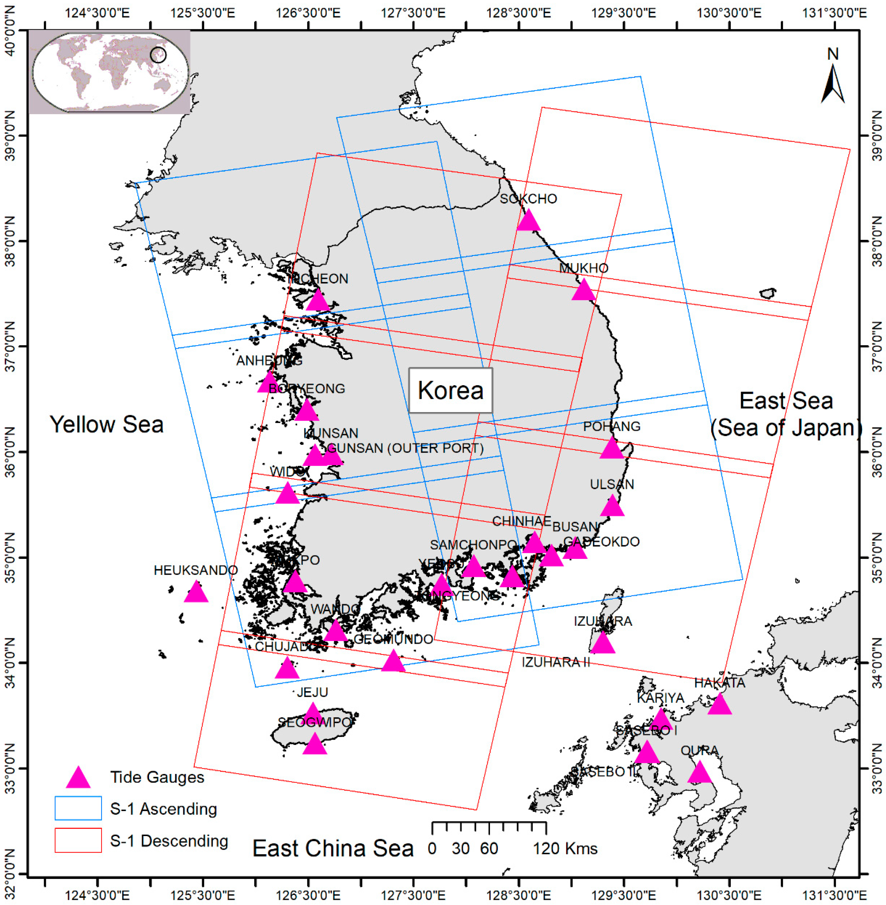
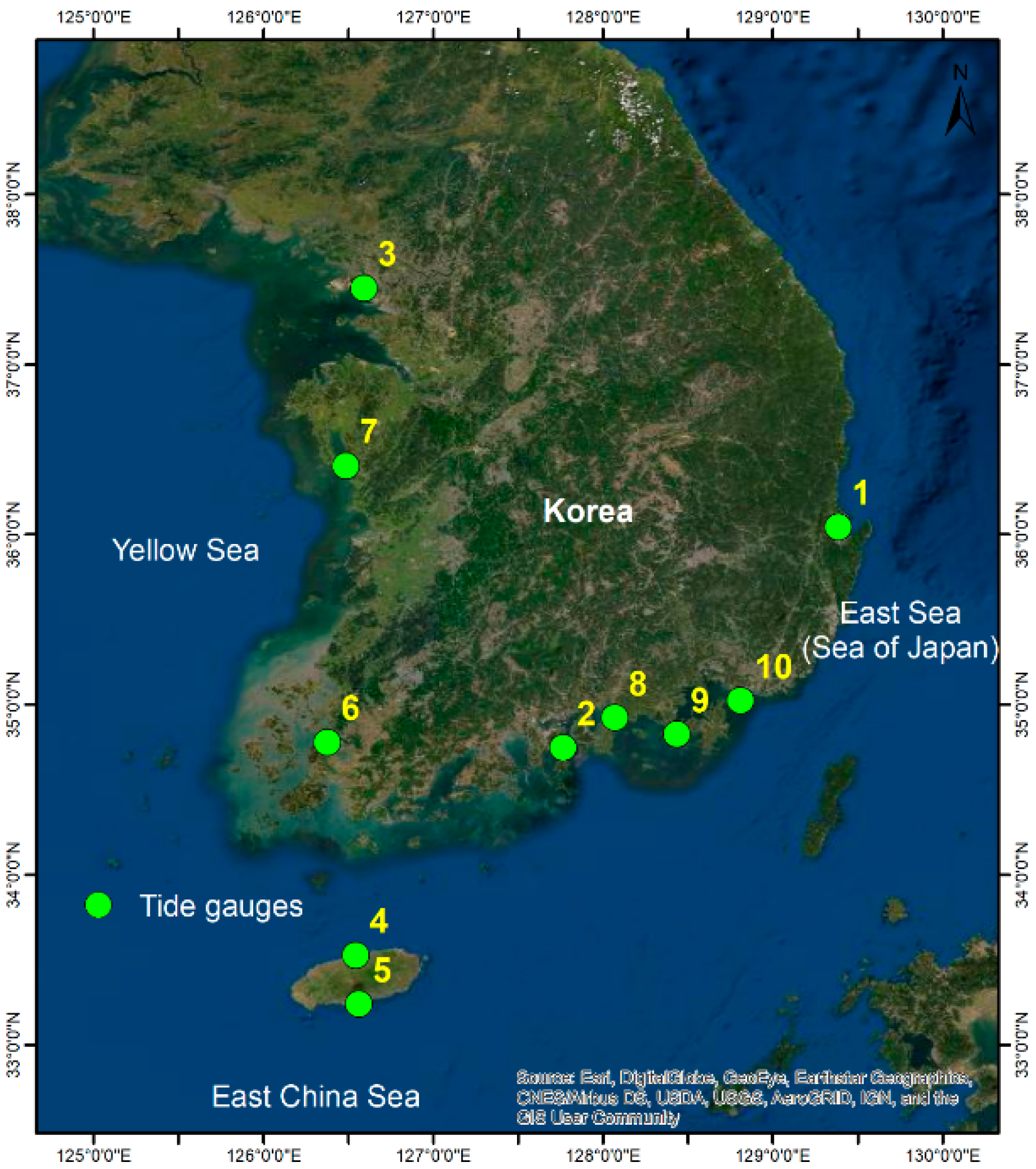
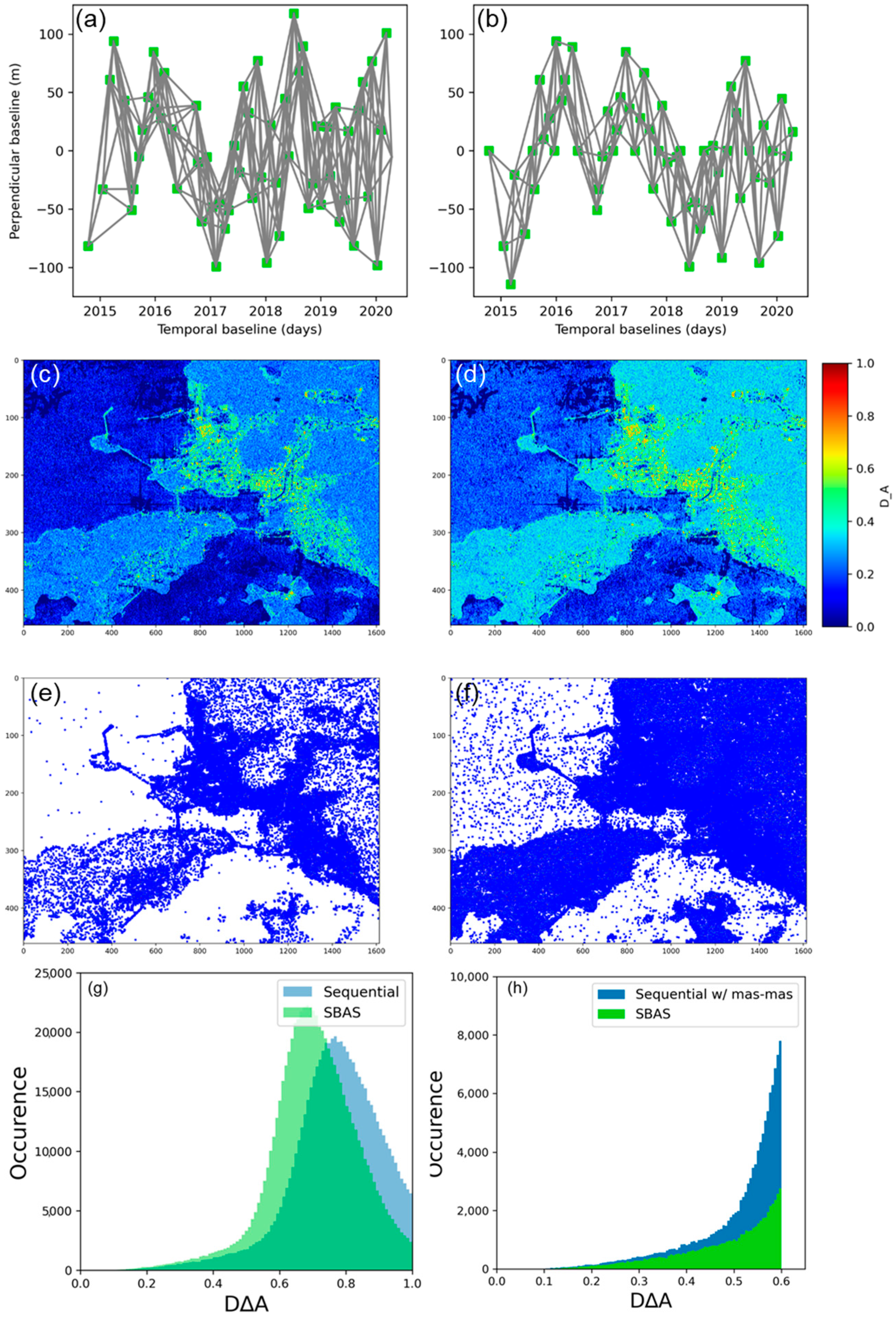
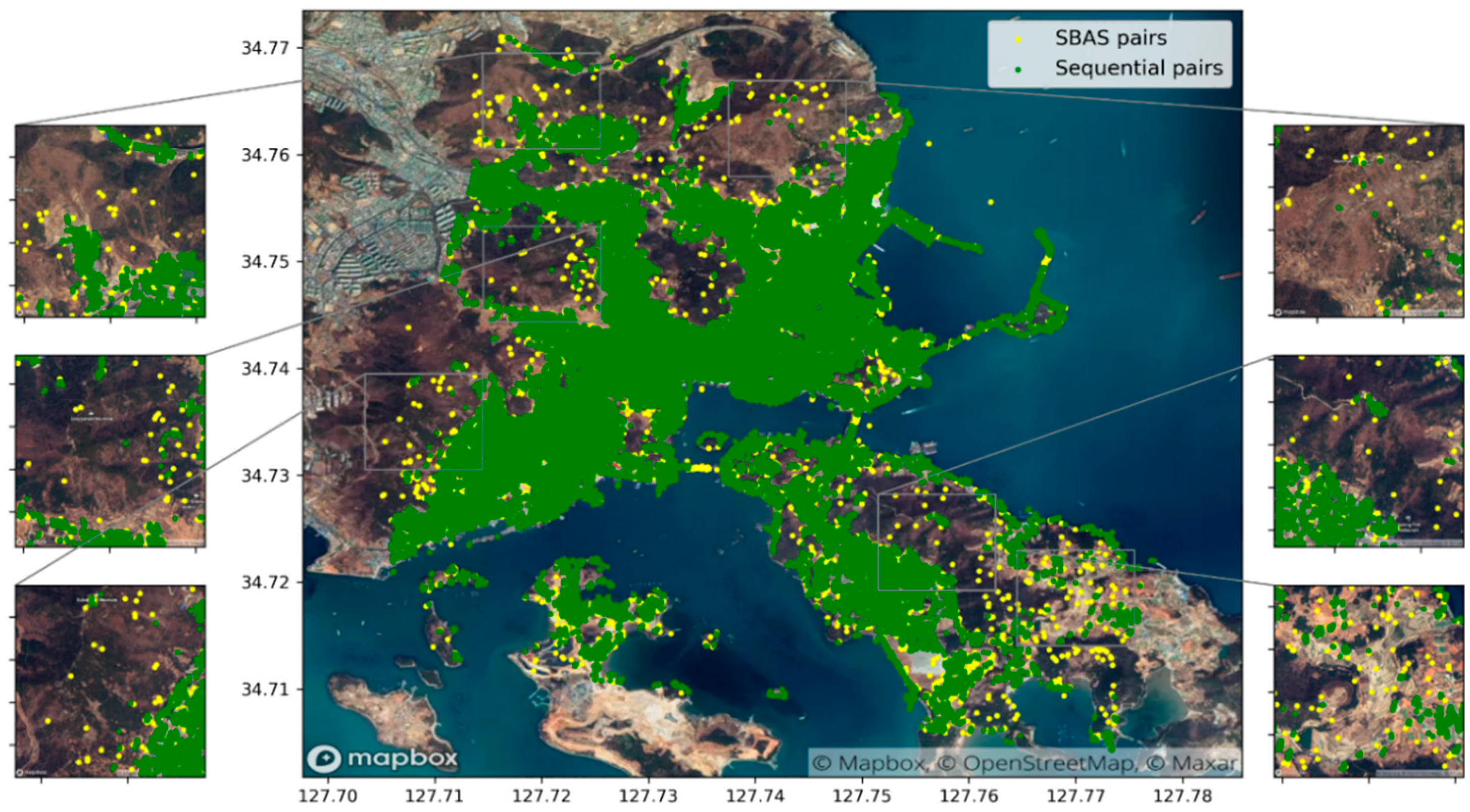
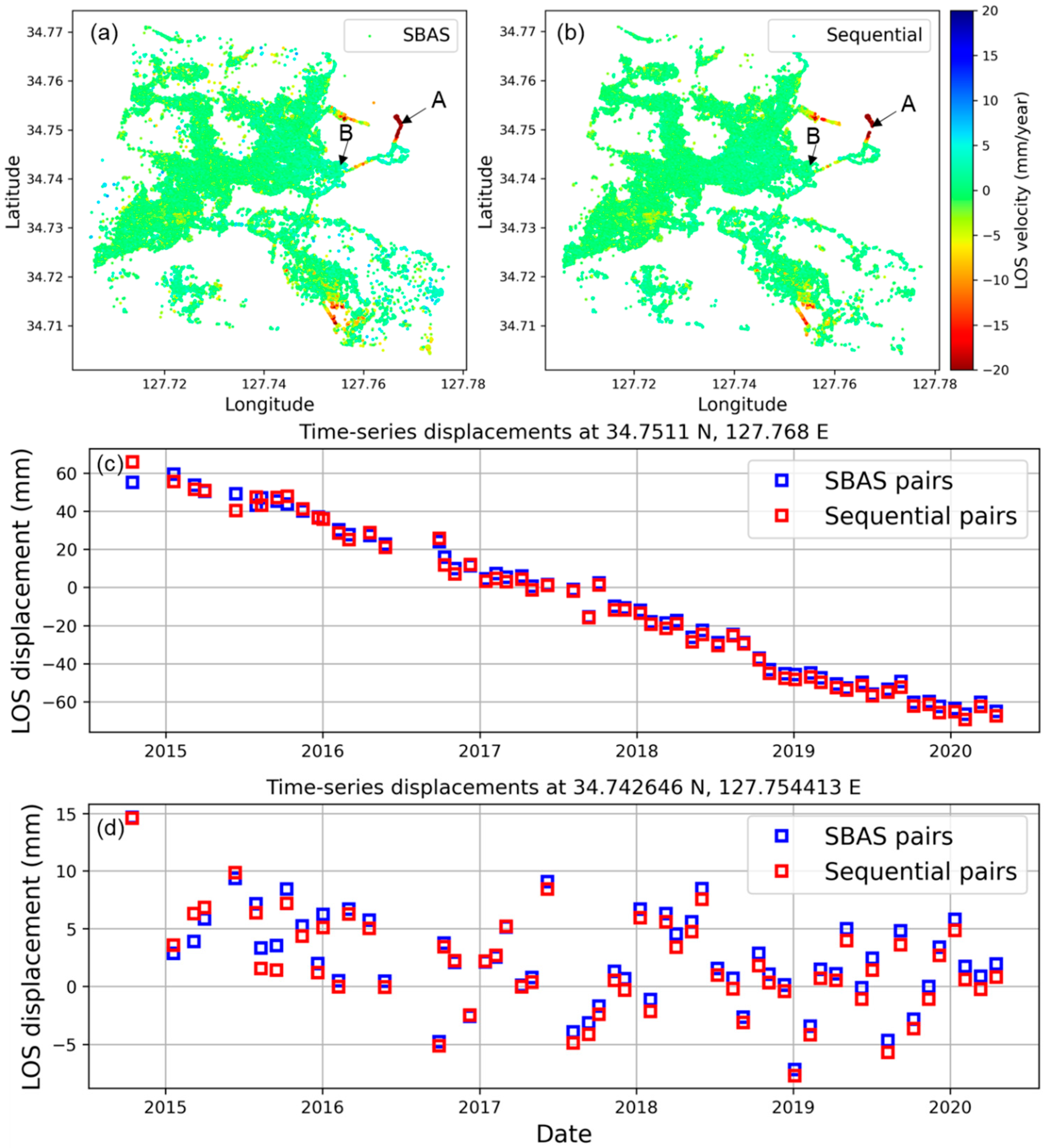
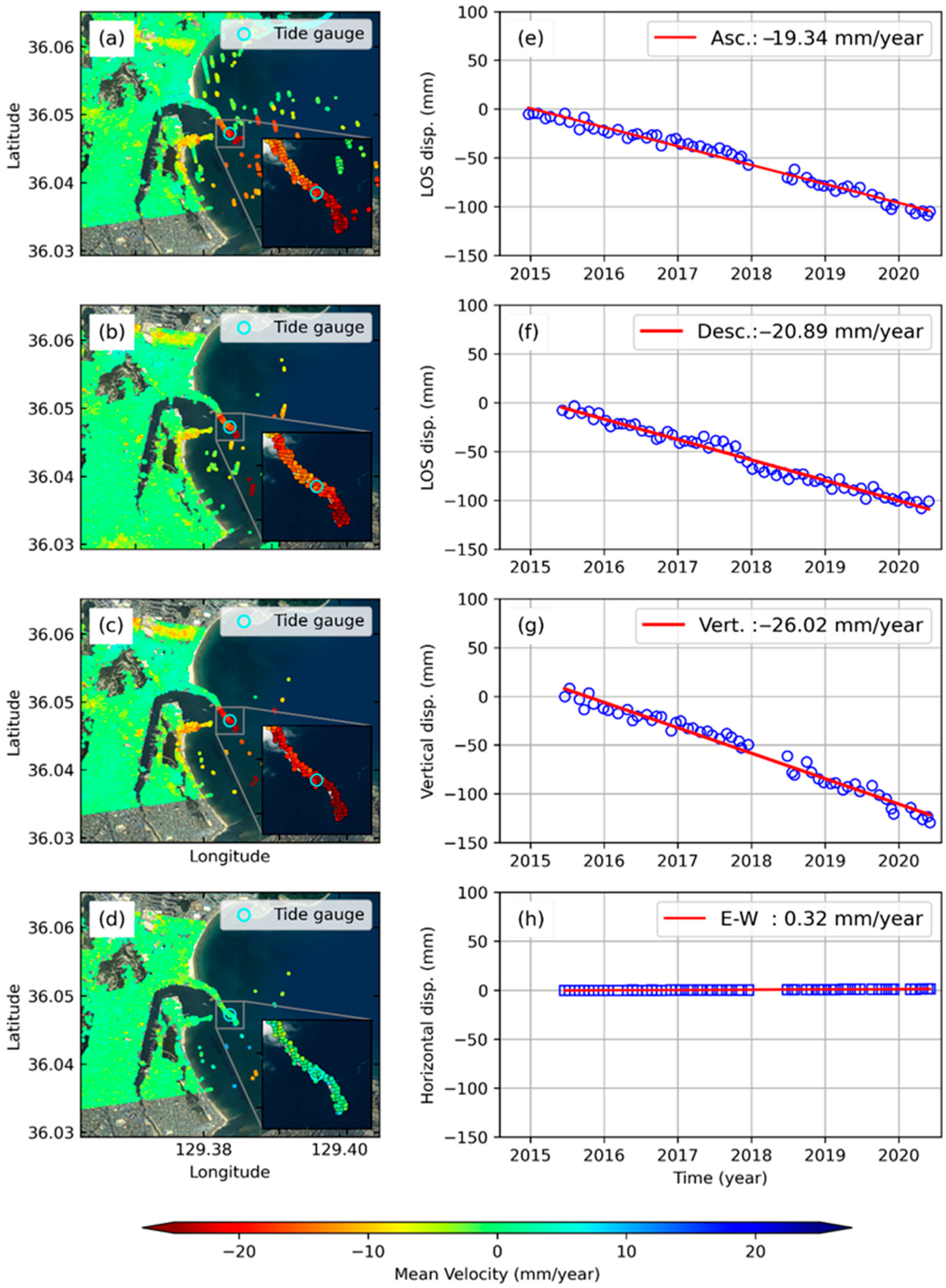


| S.No | Station Name | Latitude | Longitude |
|---|---|---|---|
| 1. | Pohang | 36.047222 | 129.383889 |
| 2. | Yeosu | 34.747198 | 127.765873 |
| 3. | Incheon | 37.451944 | 126.592222 |
| 4. | Jeju | 33.5275 | 126.543056 |
| 5. | Seogwipo | 33.24 | 126.561667 |
| 6. | Mokpo | 34.779722 | 126.375556 |
| 7. | Boryeong | 36.406389 | 126.486111 |
| 8. | Samchonpo | 34.92416667 | 128.06972222 |
| 9. | Tongyeong | 34.8275 | 128.434722 |
| 10. | Gadeokdo | 35.025 | 128.811 |
| S.No. | Description | StaMPS-SBAS | Sequential StaMPS-SBAS |
|---|---|---|---|
| 1. | Initial SDFP selected candidates | 60,731 | 124,467 |
| 2. | SDFP density (pixels/km2) | 1230 | 2520 |
| 3. | Initial gamma threshold | 0.3 | 0.3 |
| 4. | Re-estimated gamma threshold | 0.002 | 0.265 |
| 5. | Selected SDFP pixels | 55,515 | 66,792 |
| Step | Processing Step | Product Output |
|---|---|---|
| 1. | Acquisition of Sentinel-1 SAR data for each tide gauge station | SLCs stack for ascending and descending |
| 2. | ISCE TOPS stack processor | Co-registered SLC stack, N |
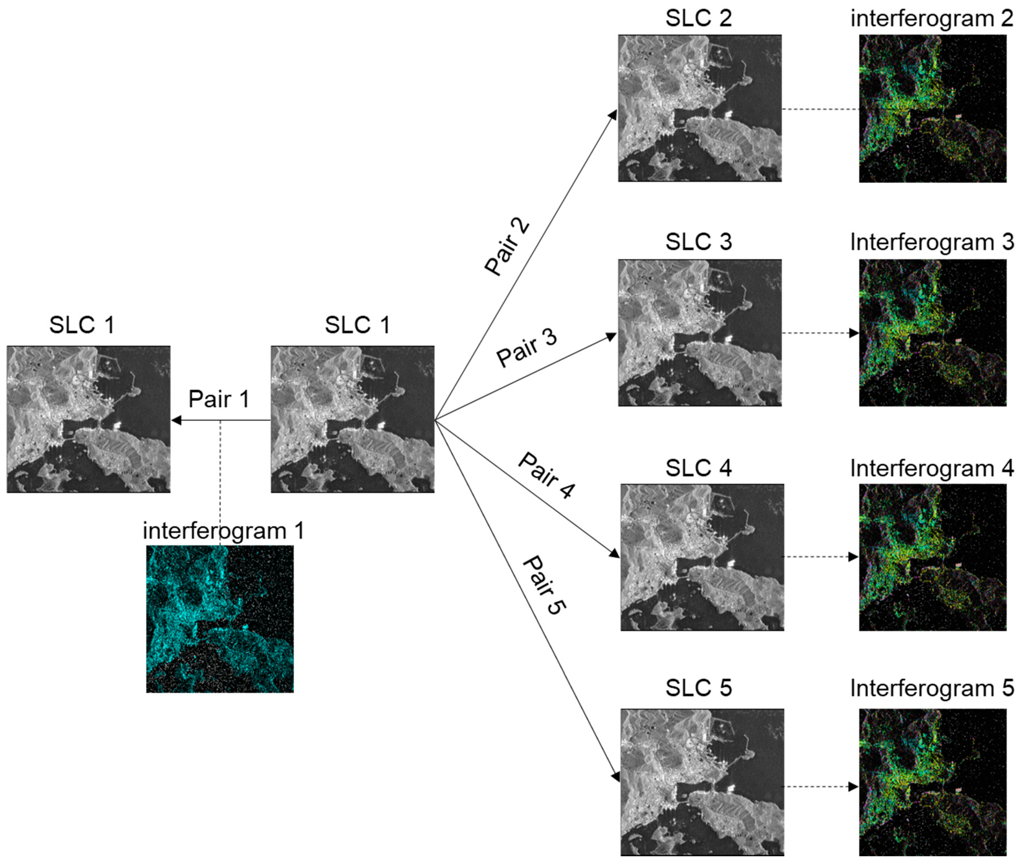
| 3. | Sequential pair selection (Section 3.1) | M sequential interferograms |
| 4. | ISCE2StaMPS | Initial SDFP candidates |
| 5. | StaMPS time-series analysis | Mean LOS velocity and time-series displacements |
| 6. | LOS2VH decomposition | Vertical and horizontal velocity and time-series displacements |
| S.No | Tide Gauge Station | Rate of Sea-Level Change (2009–2018) mm/year | InSAR VLM (mm/year) | GPS Velocity (mm/year) | |
|---|---|---|---|---|---|
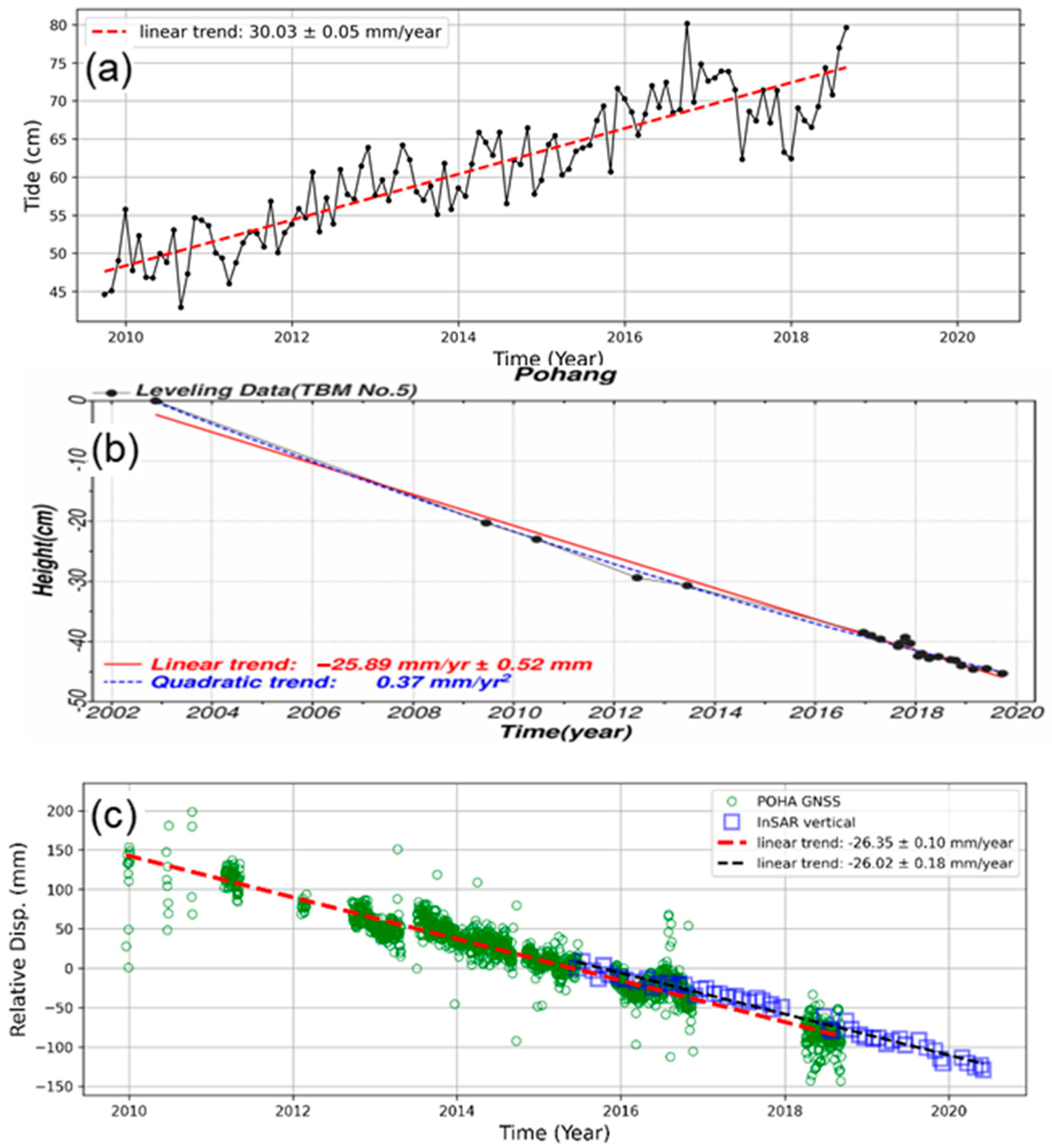
| 1. | East | Pohang | 30.03 | −26.02 | −26.35 |
| 2. | West | Incheon | 2.12 | +1.53 | N/A |
| 3. | Boryeong | 1.48 | +1.85 | N/A | |
| 4. | Mokpo | −1.00 | +0.67 | N/A | |
| 5. | South | Tongyeong | 3.3 | +1.14 | +2.21 |
| 6. | Yeosu | 1.34 | +0.45 | N/A | |
| 7. | Samchonpo | N/A | −3.59 | N/A | |
| 8. | Gadeokdo | 8.51 | No pixels | N/A | |
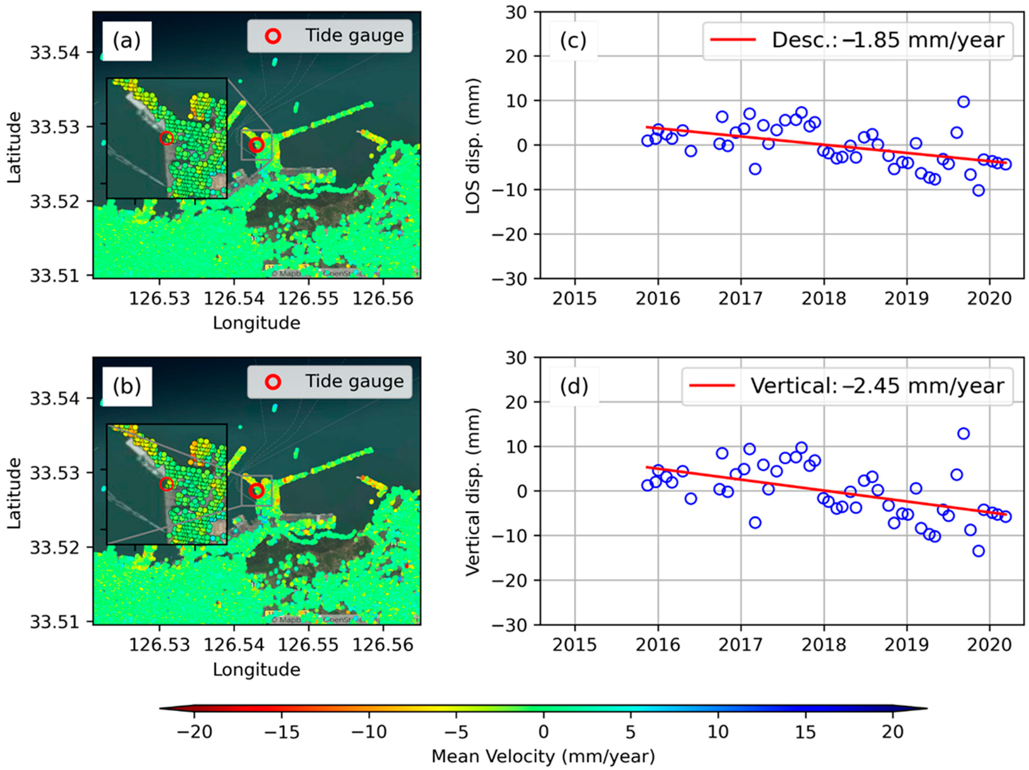
| 9. | Jeju | Jeju | −0.78 | −2.45 | N/A |
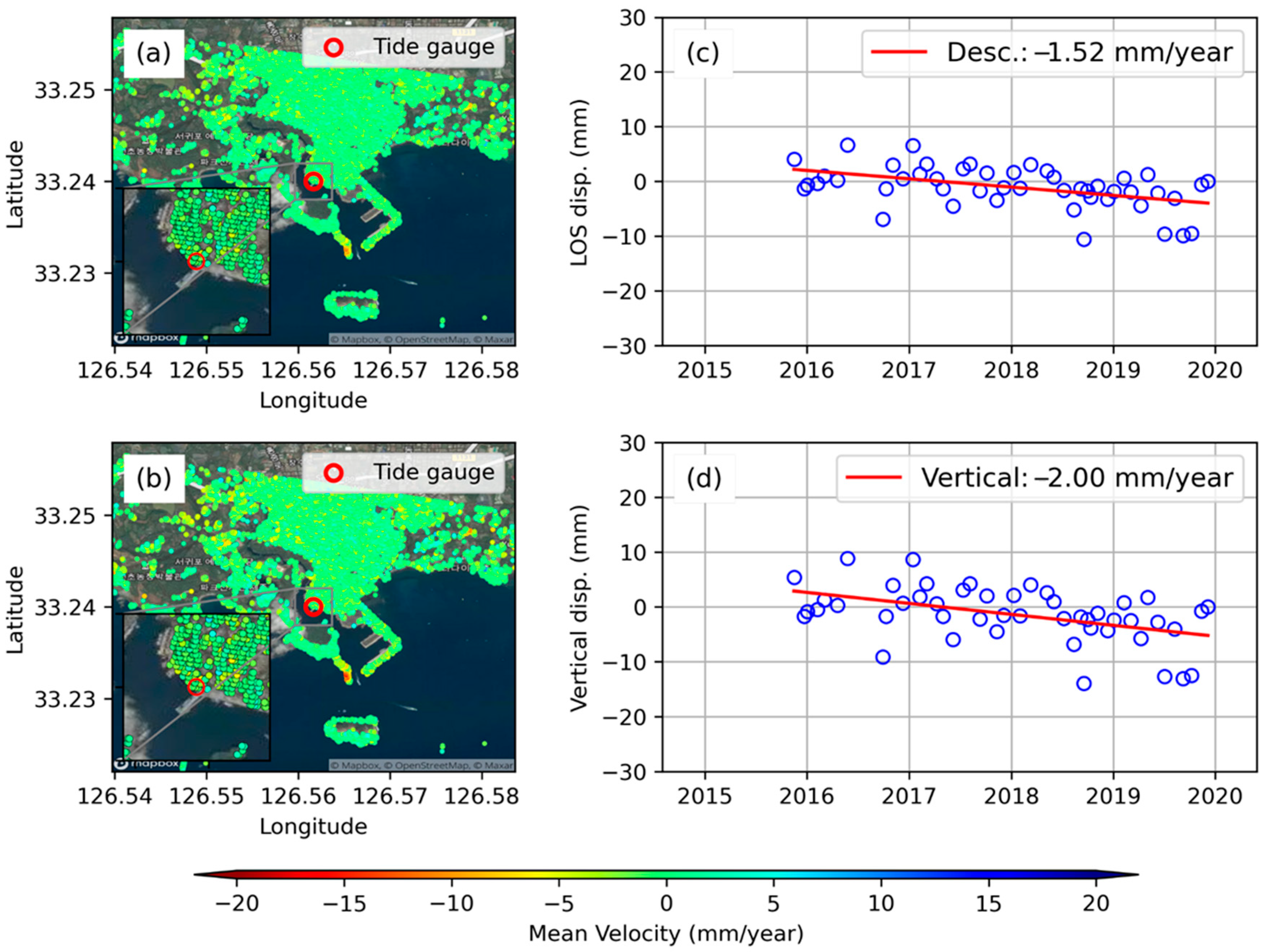
| 10. | Seogwipo | 6.18 | −2.0 | N/A | |
Publisher’s Note: MDPI stays neutral with regard to jurisdictional claims in published maps and institutional affiliations. |
© 2020 by the authors. Licensee MDPI, Basel, Switzerland. This article is an open access article distributed under the terms and conditions of the Creative Commons Attribution (CC BY) license (http://creativecommons.org/licenses/by/4.0/).
Share and Cite
Palanisamy Vadivel, S.K.; Kim, D.-j.; Jung, J.; Cho, Y.-K.; Han, K.-J. Monitoring the Vertical Land Motion of Tide Gauges and Its Impact on Relative Sea Level Changes in Korean Peninsula Using Sequential SBAS-InSAR Time-Series Analysis. Remote Sens. 2021, 13, 18. https://doi.org/10.3390/rs13010018
Palanisamy Vadivel SK, Kim D-j, Jung J, Cho Y-K, Han K-J. Monitoring the Vertical Land Motion of Tide Gauges and Its Impact on Relative Sea Level Changes in Korean Peninsula Using Sequential SBAS-InSAR Time-Series Analysis. Remote Sensing. 2021; 13(1):18. https://doi.org/10.3390/rs13010018
Chicago/Turabian StylePalanisamy Vadivel, Suresh Krishnan, Duk-jin Kim, Jungkyo Jung, Yang-Ki Cho, and Ki-Jong Han. 2021. "Monitoring the Vertical Land Motion of Tide Gauges and Its Impact on Relative Sea Level Changes in Korean Peninsula Using Sequential SBAS-InSAR Time-Series Analysis" Remote Sensing 13, no. 1: 18. https://doi.org/10.3390/rs13010018
APA StylePalanisamy Vadivel, S. K., Kim, D.-j., Jung, J., Cho, Y.-K., & Han, K.-J. (2021). Monitoring the Vertical Land Motion of Tide Gauges and Its Impact on Relative Sea Level Changes in Korean Peninsula Using Sequential SBAS-InSAR Time-Series Analysis. Remote Sensing, 13(1), 18. https://doi.org/10.3390/rs13010018


