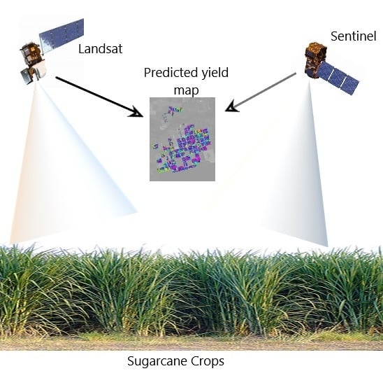
Integrating Landsat-8 and Sentinel-2 Time Series Data for Yield Prediction of Sugarcane Crops at the Block Level


Abstract
1. Introduction
- Develop a conversion algorithm that enables the transition of the Landsat-8 GNDVI time series model for sugarcane to the higher spatial and temporal resolution Sentinel-2A and Sentinel-2B satellite.
- Improve the accuracies of the existing time series model at the individual block level by introducing sugarcane planting or previous harvest date.
2. Materials and Methods
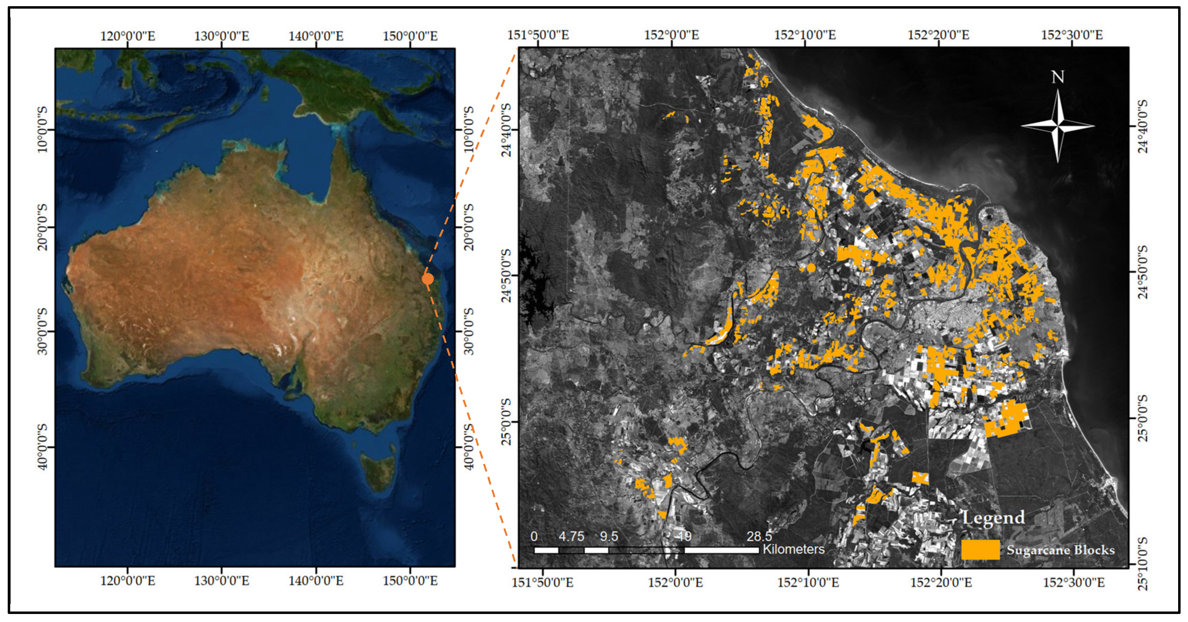
2.1. Study Area and Crop
2.2. Satellite Data Acquisition and Preprocessing
2.3. Sugarcane Block Boundary Data
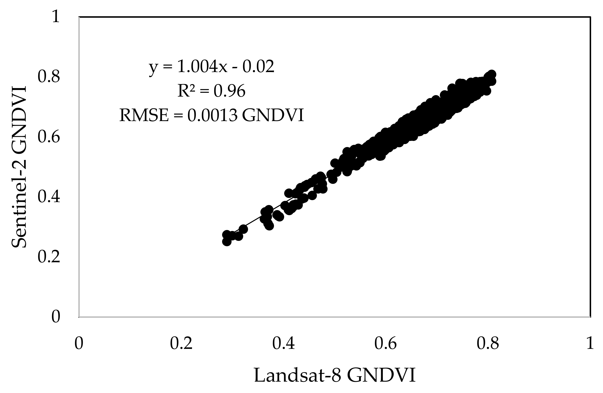
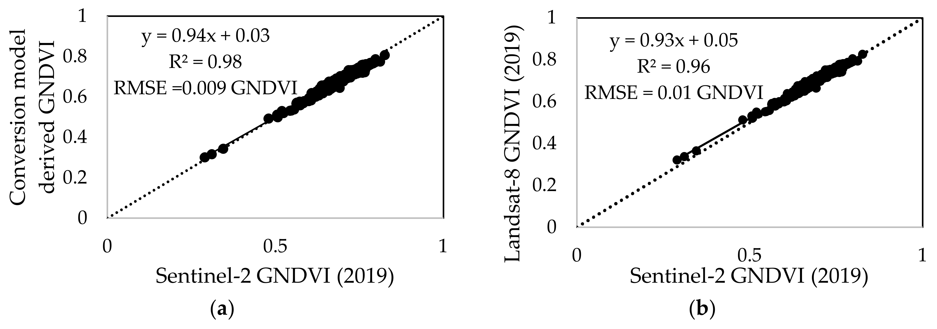
2.4. GNDVI Conversion for Landsat-8 and Sentinel-2
2.5. Yield Prediction Model Development
2.6. Statistical Analysis
3. Results
3.1. GNDVI Conversion Algorithm for Landsat-8 and Sentinel-2
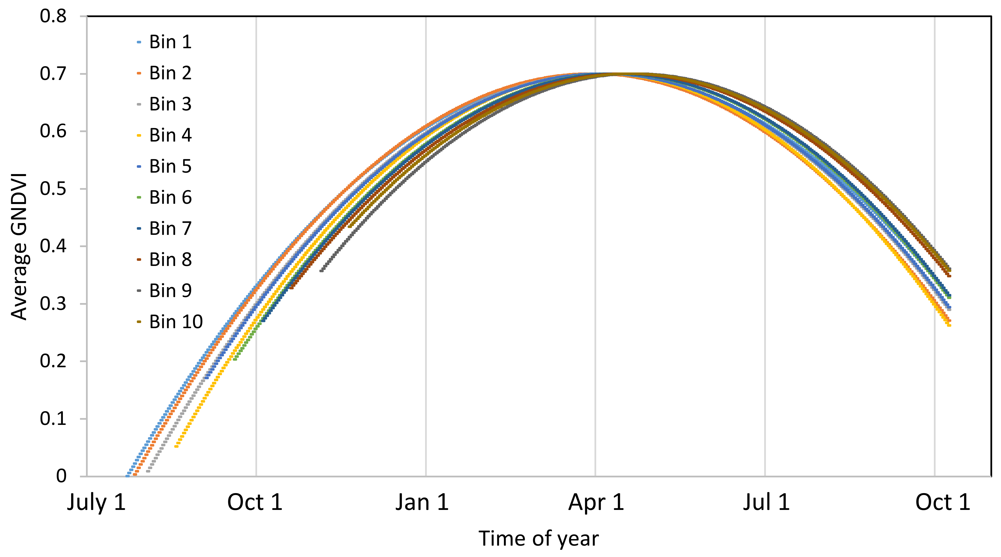
3.2. Temporal Profile of GNDVI on Bin Level
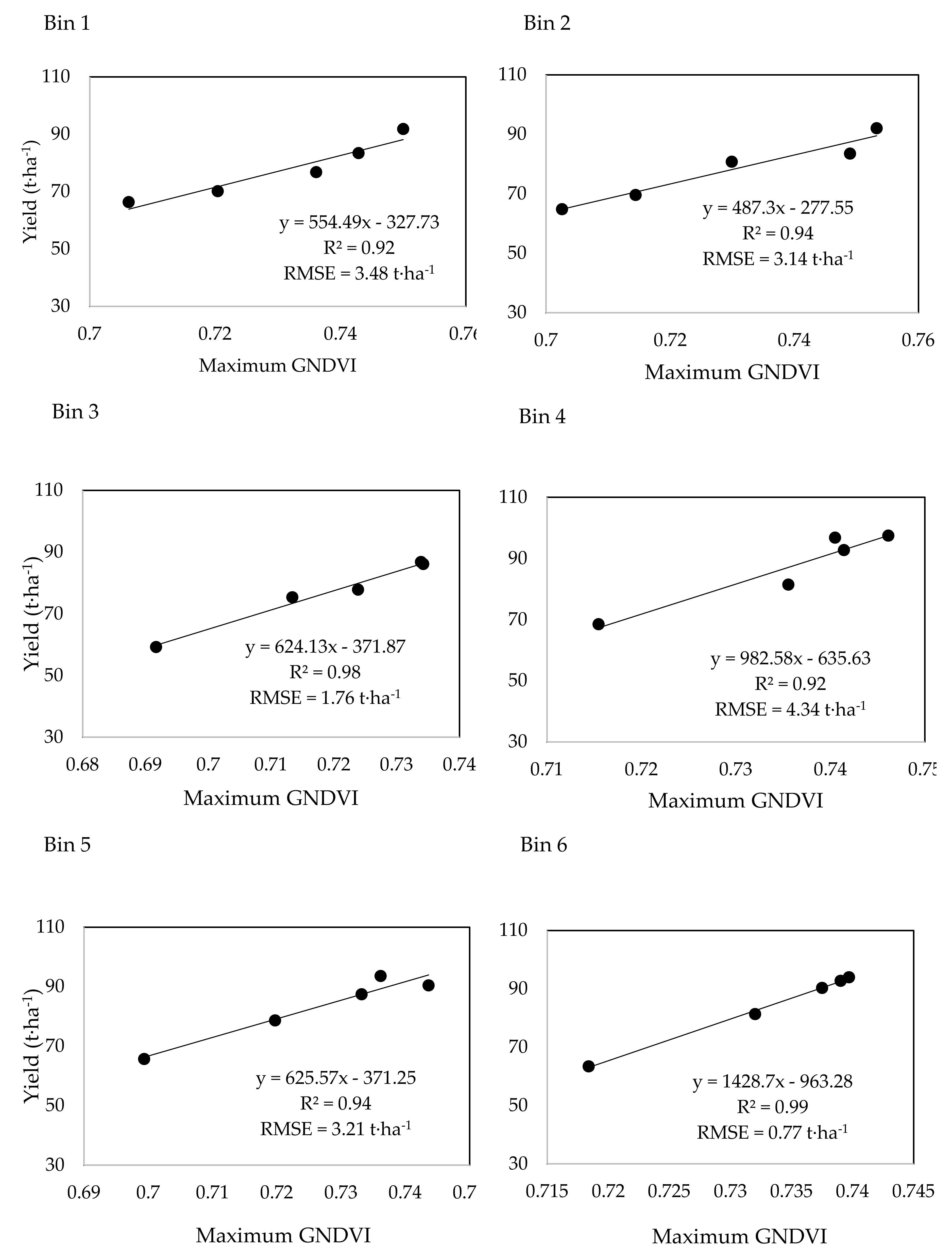
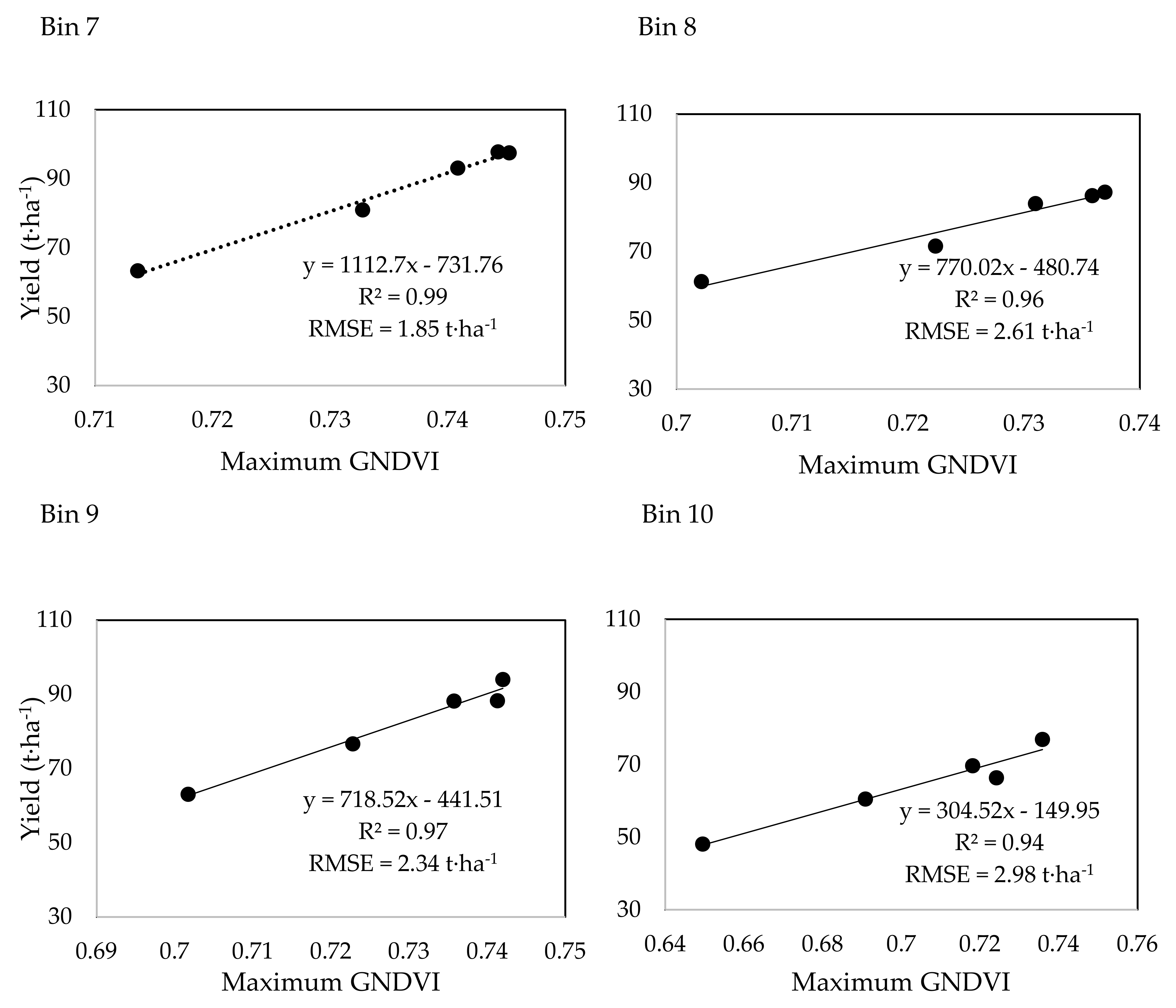
3.3. Bin Level Prediction Model
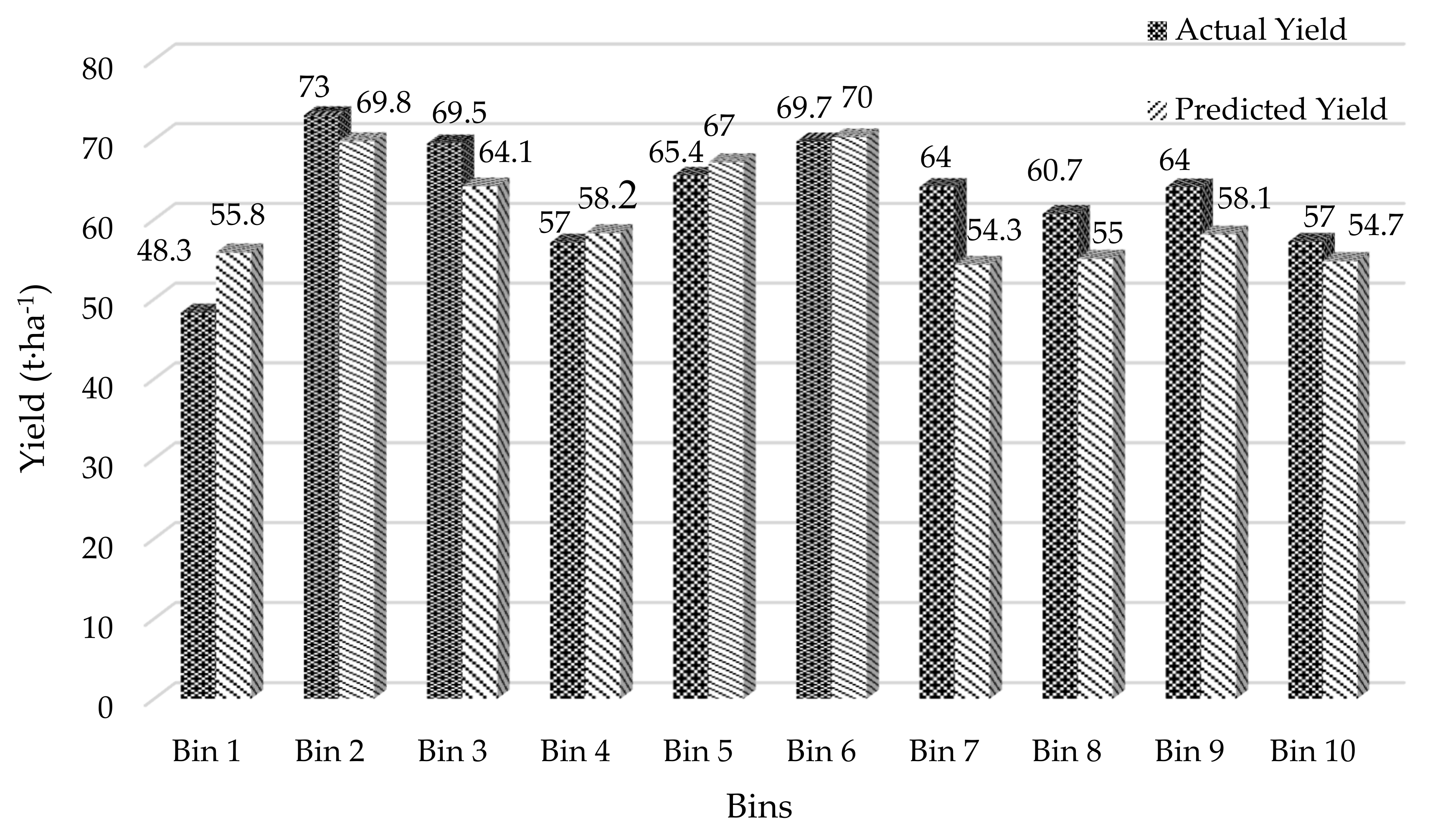
3.4. Bin Level Prediction Accuracy
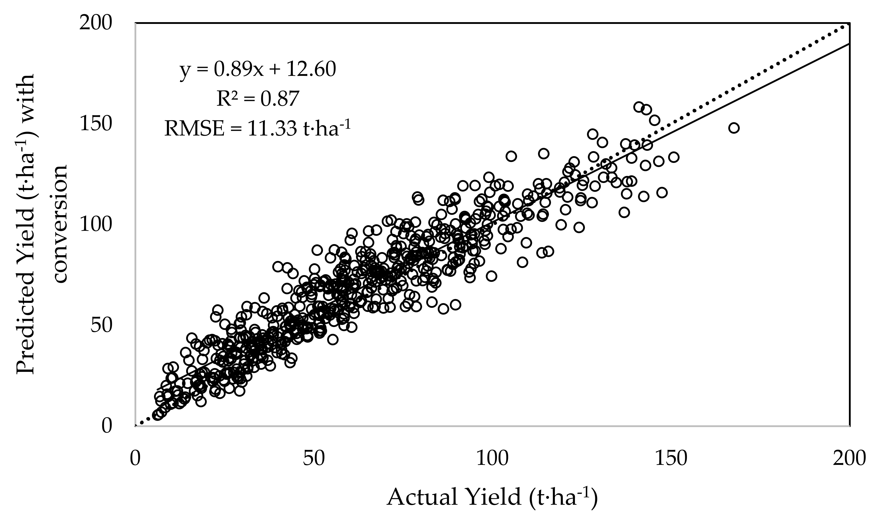
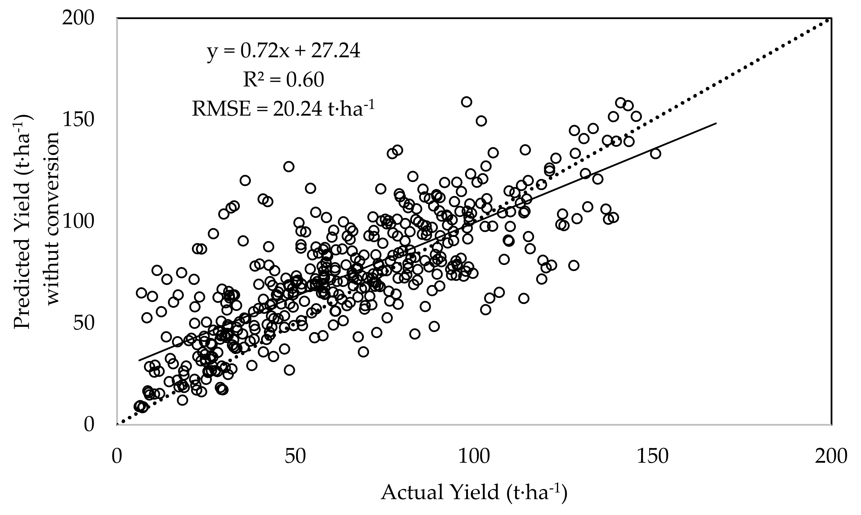
3.5. Block Level Prediction Accuracy
4. Discussion
5. Conclusions
Author Contributions
Funding
Acknowledgments
Conflicts of Interest
References
- ABS. Australian Bureau of Statistics. Agricultural Commodities, Australia, ‘Table 1: Agricultural Commodities—Australia—2016-17’, Data Cube: Excel Spreadsheet, Cat. No. 71210. 2018. Available online: https://www.abs.gov.au/AUSSTATS/abs@.nsf/DetailsPage/7121.02016-17?OpenDocument (accessed on 26 July 2019).
- Australian Government Department of Agriculture. Available online: http://www.agriculture.gov.au/ag-farm-food/crops/sugar (accessed on 26 July 2019).
- Jensen, T.A.; Baillie, C.; Bramley, R.G.V.; Panitz, J.H. An assessment of sugarcane yield monitoring concepts and techniques from commercial yield monitoring systems. In Proceedings of the 34th Annual Conference of the Australian Society of Sugarcane Technologists (ASSCT), Palm Cove, Australia, 1–4 May 2012; p. 7. [Google Scholar]
- Robson, A.; Abbott, C.; Lamb, D.; Bramley, R. Developing sugarcane yield prediction algorithms from satellite imagery. In Proceedings of the 34th Annual Conference of the Australian Society of Sugarcane Technologists (ASSCT), Palm Cove, Australia, 1–4 May 2012; pp. 452–462. [Google Scholar]
- Rahman, M.M.; Robson, A.J. A Novel Approach for Sugarcane Yield Prediction Using Landsat Time Series Imagery: A Case Study on Bundaberg Region. Adv. Remote Sens. 2016, 5, 93–102. [Google Scholar] [CrossRef]
- Rahman, M.M.; Robson, A.J. Multi-temporal remote sensing for yield prediction in sugarcane crops. In Proceedings of the 19th Symposium of Society of Precision Agriculture Australia Towoomba, QLD, Australia, 12–13 September 2016. [Google Scholar]
- Lobell, D.B. The use of satellite data for crop yield gap analysis. Field Crop. Res. 2013, 143, 56–64. [Google Scholar] [CrossRef]
- Mulianga, B.; Bégué, A.; Simoes, M.; Todoroff, P. Forecasting Regional Sugarcane Yield Based on Time Integral and Spatial Aggregation of MODIS NDVI. Remote Sens. 2013, 5, 2184–2199. [Google Scholar] [CrossRef]
- El Hajj, M.; Bégué, A.; Guillaume, S.; Martiné, J.-F. Integrating SPOT-5 time series, crop growth modeling and expert knowledge for monitoring agricultural practices—The case of sugarcane harvest on Reunion Island. Remote Sens. Environ. 2009, 113, 2052–2061. [Google Scholar] [CrossRef]
- Bégué, A.; Lebourgeois, V.; Bappel, E.; Todoroff, P.; Pellegrino, A.; Baillarin, F.; Siegmund, B. Spatio-temporal variability of sugarcane fields and recommendations for yield forecast using NDVI. Int. J. Remote Sens. 2010, 31, 5391–5407. [Google Scholar] [CrossRef]
- Gonçalves, R.R.V.; Nascimento, C.R.; Zullo, J., Jr.; Romani, L.A.S. Relationship between the spectral response of sugarcane, based on AVHRR/NOAA satellite images, and the climate condition, in the state of Sao Paulo (Brazil), from 2001 to 2008. In Proceedings of the Fifth International Workshop on the Analysis of Multi-temporal Remote Sensing Images, Groton, CT, USA, 28–30 July 2009; pp. 315–322. [Google Scholar]
- Nascimento, C.R.; Gonçalves, R.R.V.; Zullo, J., Jr.; Romani, L.A.S. Estimation of sugarcane productivity using a time series of AVHRR/NOAA-17 images and a phenology-spectral model. In Proceedings of the Fifth International Workshop on the Analysis of Multi-temporal Remote Sensing images, Groton, CT, USA, 28–30 July 2009; pp. 365–372. [Google Scholar]
- Xavier, A.C.; Rudorff, B.F.T.; Shimabukuro, Y.E.; Berka, L.M.S.; Moreira, M.A. Multi-temporal analysis of MODIS data to classify sugarcane crop. Int. J. Remote Sens. 2006, 27, 755–768. [Google Scholar] [CrossRef]
- Bastidas-Obando, E.; Carbonell-Gonzalez, J. Evaluating the Applicability of MODIS Data for Forecasting Sugarcane Yields in Colombia. In Proceedings of the International Society of Sugarcane Technologists (ISSCT), Durban, South Africa, 29 July–2 August 2007. [Google Scholar]
- Meng, J.; Wu, B.; Li, Q.; Du, X.; Jia, K. Monitoring Crop Phenology with MERIS Data—A Case Study of Winter Wheat in North China Plain. In Proceedings of the Progress In Electromagnetics Research Symposium, Beijing, China, 23–27 March 2009; pp. 1225–1228. [Google Scholar]
- Zurita-Milla, R.; Gomez-Chova, L.; Guanter, L.; Clevers, J.G.P.W.; Camps-Valls, G. Multitemporal Unmixing of Medium-Spatial-Resolution Satellite Images: A Case Study Using MERIS Images for Land-Cover Mapping. IEEE Trans. Geosci. Remote Sens. 2011, 49, 4308–4317. [Google Scholar] [CrossRef]
- Si, Y.; Schlerf, M.; Zurita-Milla, R.; Skidmore, A.; Wang, T. Mapping spatio-temporal variation of grassland quantity and quality using MERIS data and the PROSAIL model. Remote Sens. Environ. 2012, 121, 415–425. [Google Scholar] [CrossRef]
- Fernandes, J.L.; Rocha, J.V.; Lamparelli, R.A.C. Sugarcane yield estimates using time series analysis of spot vegetation images. Sci. Agric. 2011, 68, 139–146. [Google Scholar] [CrossRef]
- Morel, J.; Todoroff, P.; Bégué, A.; Bury, A.; Martiné, J.-F.; Petit, M. Toward a Satellite-Based System of Sugarcane Yield Estimation and Forecasting in Smallholder Farming Conditions: A Case Study on Reunion Island. Remote Sens. 2014, 6, 6620. [Google Scholar] [CrossRef]
- Lu, D.; Hetrick, S.; Moran, E.; Li, G. Application of Time Series Landsat Images to Examining Land-use/Land-cover Dynamic Change. Photogramm. Eng. Remote Sens. 2012, 78, 747–755. [Google Scholar] [CrossRef] [PubMed]
- Lehmann, E.A.; Wallace, J.F.; Caccetta, P.A.; Furby, S.L.; Zdunic, K. Forest cover trends from time series Landsat data for the Australian continent. Int. J. Appl. Earth Obs. Geoinf. 2013, 21, 453–462. [Google Scholar] [CrossRef]
- Rahman, M.M.; Muir, J.; Robson, A. Multi-temporal Landsat algorithms for the yield prediction of sugarcane crops in Australia. In Proceedings of the 7th Asian-Australasian Conference on Precision Agriculture, Hamilton, Newzealand, 16–18 October 2017. [Google Scholar]
- Muir, J.; Robson, A.; Rahman, M.M. ‘Sugar from space’: Using satllite imagery to predict cane yield variability and nitrogen uptake. In Proceedings of the 40th ASSCT Conference, Mackay, Australia, 17–20 April 2018. [Google Scholar]
- Duveiller, G.; López-Lozano, R.; Baruth, B. Enhanced Processing of 1-km Spatial Resolution fAPAR Time Series for Sugarcane Yield Forecasting and Monitoring. Remote Sens. 2013, 5, 1091–1116. [Google Scholar] [CrossRef]
- Morel, J.; Bégué, A.; Todoroff, P.; Martiné, J.-F.; Lebourgeois, V.; Petit, M. Coupling a sugarcane crop model with the remotely sensed time series of fIPAR to optimise the yield estimation. Eur. J. Agron. 2014, 61, 60–68. [Google Scholar] [CrossRef]
- Laneve, G.; Marzialetti, P.; Luciani, R.; Fusilli, L.; Mulianga, B. Sugarcane biomass estimate based on sar imagery: A radar systems comparison. In Proceedings of the 2017 IEEE International Geoscience and Remote Sensing Symposium (IGARSS), Fort Worth, TX, USA, 23–28 July 2017; pp. 5834–5837. [Google Scholar] [CrossRef]
- Molijn, R.A.; Iannini, L.; Vieira Rocha, J.; Hanssen, R.F. Sugarcane productivity mapping through C-band and L-band SAR and optical satellite imagery. Remote Sens. 2019, 11, 1109. [Google Scholar] [CrossRef]
- Baghdadi, N.; Boyer, N.; Todoroff, P.; El Hajj, M.; Bégué, A. Potential of SAR sensors TerraSAR-X, ASAR/ENVISAT and PALSAR/ALOS for monitoring sugarcane crops on Reunion Island. Remote Sens. Environ. 2009, 113, 1724–1738. [Google Scholar] [CrossRef]
- Picoli, M.C.A.; Lamparelli, R.A.C.; Sano, E.E.; Rocha, J.V. The use of ALOS/PALSAR data for estimating sugarcane productivity. Eng. Agrícola 2014, 34, 1245–1255. [Google Scholar] [CrossRef]
- Yuan, X.; Li, H.; Han, Y.; Chen, J.; Chen, X. Monitoring of Sugarcane Crop based on Time Series of Sentinel-1 data: A case study of Fusui, Guangxi. In Proceedings of the 2019 8th International Conference on Agro-Geoinformatics (Agro-Geoinformatics), Istanbul, Turkey, 16–19 July 2019; pp. 1–5. [Google Scholar] [CrossRef]
- Drusch, M.; Del Bello, U.; Carlier, S.; Colin, O.; Fernandez, V.; Gascon, F.; Hoersch, B.; Isola, C.; Laberinti, P.; Martimort, P.; et al. Sentinel-2: ESA’s Optical High-Resolution Mission for GMES Operational Services. Remote Sens. Environ. 2012, 120, 25–36. [Google Scholar] [CrossRef]
- Landgrebe, D.A.; Hoffer, R.M.; Goodrick, F.E. An Early Analysis of ERTS-1 Data. In Proceedings of the Earth Resources Technology Satellite-1 Symposium, Goddard Spaceflight Center, Greenbelt, MD, USA, 29 September 1972. [Google Scholar]
- Loveland, T.R.; Dwyer, J.L. Landsat: Building a strong future. Remote Sens. Environ. 2012, 122, 22–29. [Google Scholar] [CrossRef]
- Roy, D.P.; Wulder, M.A.; Loveland, T.R.; Woodcock, C.E.; Allen, R.G.; Anderson, M.C.; Helder, D.; Irons, J.R.; Johnson, D.M.; Kennedy, R.; et al. Landsat-8: Science and product vision for terrestrial global change research. Remote Sens. Environ. 2014, 145, 154–172. [Google Scholar] [CrossRef]
- Flood, N. Comparing Sentinel-2A and Landsat 7 and 8 using surface reflectance over Australia. Remote Sens. 2017, 9, 659. [Google Scholar] [CrossRef]
- Mandanici, E.; Bitelli, G. Preliminary comparison of sentinel-2 and landsat 8 imagery for a combined use. Remote Sens. 2016, 8, 1014. [Google Scholar] [CrossRef]
- Wang, Q.; Blackburn, G.A.; Onojeghuo, A.O.; Dash, J.; Zhou, L.; Zhang, Y.; Atkinson, P.M. Fusion of Landsat 8 OLI and Sentinel-2 MSI Data. IEEE Trans. Geosci. Remote Sens. 2017, 55, 3885–3899. [Google Scholar] [CrossRef]
- Claverie, M.; Masek, J.G.; Ju, J.; Dungan, J.L. Harmonized Landsat-8 Sentinel-2 (HLS) Product User’s Guide. Available online: https://hls.gsfc.nasa.gov/wp-content/uploads/2017/03/HLS.v1.2.UserGuide.pdf (accessed on 14 October 2019).
- Vuolo, F.; Żółtak, M.; Pipitone, C.; Zappa, L.; Wenng, H.; Immitzer, M.; Weiss, M.; Baret, F.; Atzberger, C. Data service platform for Sentinel-2 surface reflectance and value-added products: System use and examples. Remote Sens. 2016, 8, 938. [Google Scholar] [CrossRef]
- Robson, A.; Rahman, M.M.; Falzon, G.; Verma, N.K.; Johansen, K.; Robinson, N.; Lakshmanan, P.; Salter, B.; Skocaj, D. Evaluating remote sensing technologies for improved yield forecasting and for the measurement of foliar nitrogen concentration in sugarcane. In Proceedings of the 38th Australian Society of Sugar Cane Technologists, Mackay, Queensland, Australia, 27–29 April 2016. [Google Scholar]
- BOM. Bureau of Meteorology. Available online: http://www.bom.gov.au (accessed on 15 September 2019).
- Mueller-Wilm, U. Sen2Cor Software Release Note. Available online: http://step.esa.int/thirdparties/sen2cor/2.8.0/docs/S2-PDGS-MPC-L2A-SRN-V2.8.pdf (accessed on 15 September 2019).
- Gitelson, A.A.; Kaufman, Y.J.; Merzlyak, M.N. Use of a green channel in remote sensing of global vegetation from EOS-MODIS. Remote Sens. Environ. 1996, 58, 289–298. [Google Scholar] [CrossRef]
- R Development Core Team. R: A Language and Environment for Statistical Computing (Version 3.5); R Foundation for Statistical Computing: Vienna, Austria, 2018. [Google Scholar]
- Tuszynski, J.; Tuszynski, M.J. The caTools Package. 2007. Available online: https://cran.r-project.org/web/packages/caTools/caTools.pdf (accessed on 18 November 2019).
- Robson, A.; Wright, G. Accurate Regional to Field Scale Yield forecasting of Australian Sugarcane and Peanut Crops using Remote Sensing and GIS. In Proceedings of the Asia-Pacific Economic Cooperation (APEC): Training Course on the Application of Remote Sensing and GIS Technology in Crop Production, Beijing, China, 13 November 2013. [Google Scholar]


| Satellite | Date | Time (UTC) | Sun Elevation (°) | Sun Azimuth (°) |
|---|---|---|---|---|
| Landsat-8 | 2016-06-29 | 23:47:20.468 | 33.28313465 | 35.21029636 |
| Sentinel-2 | 00:02:19.460 | 35.03771162 | 31.08598346 | |
| Landsat-8 | 2017-05-15 | 23:46:56.737 | 37.54211453 | 36.43211030 |
| Sentinel-2 | 00:02:21.026 | 39.63220987 | 32.06687238 | |
| Landsat-8 | 2018-06-19 | 23:46:27.002 | 33.22617686 | 34.73077325 |
| Sentinel-2 | 00:02:41.024 | 35.11356882 | 30.43385100 | |
| Landsat-8 | 2019-05-05 | 23:46:58.35 | 39.68742589 | 38.53144620 |
| Sentinel-2 | 00:02:41.024 | 41.92912089 | 34.06945308 |
© 2020 by the authors. Licensee MDPI, Basel, Switzerland. This article is an open access article distributed under the terms and conditions of the Creative Commons Attribution (CC BY) license (http://creativecommons.org/licenses/by/4.0/).
Share and Cite
Rahman, M.M.; Robson, A. Integrating Landsat-8 and Sentinel-2 Time Series Data for Yield Prediction of Sugarcane Crops at the Block Level. Remote Sens. 2020, 12, 1313. https://doi.org/10.3390/rs12081313
Rahman MM, Robson A. Integrating Landsat-8 and Sentinel-2 Time Series Data for Yield Prediction of Sugarcane Crops at the Block Level. Remote Sensing. 2020; 12(8):1313. https://doi.org/10.3390/rs12081313
Chicago/Turabian StyleRahman, Muhammad Moshiur, and Andrew Robson. 2020. "Integrating Landsat-8 and Sentinel-2 Time Series Data for Yield Prediction of Sugarcane Crops at the Block Level" Remote Sensing 12, no. 8: 1313. https://doi.org/10.3390/rs12081313
APA StyleRahman, M. M., & Robson, A. (2020). Integrating Landsat-8 and Sentinel-2 Time Series Data for Yield Prediction of Sugarcane Crops at the Block Level. Remote Sensing, 12(8), 1313. https://doi.org/10.3390/rs12081313