Fully Convolutional Networks with Multiscale 3D Filters and Transfer Learning for Change Detection in High Spatial Resolution Satellite Images


Abstract
:1. Introduction
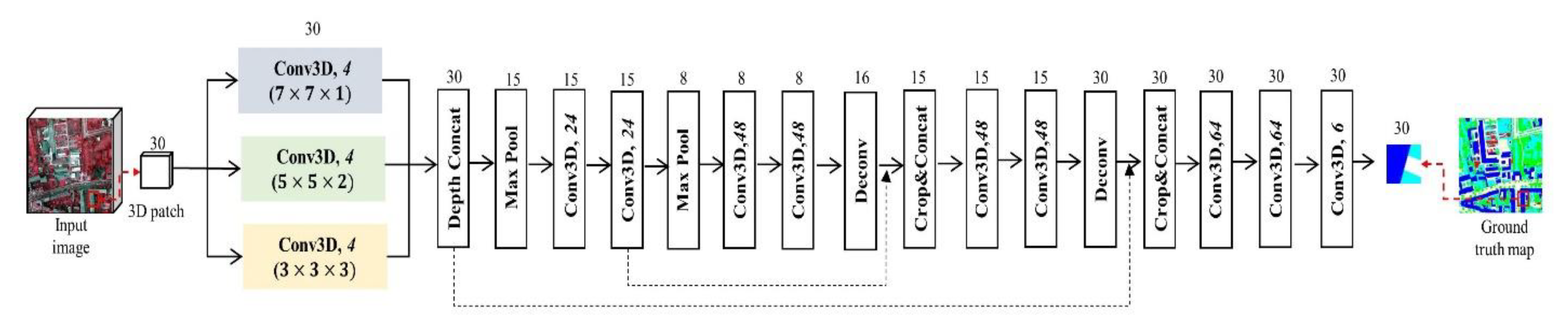
- Specialized 3D filters for spatial and spectral information were utilized to combine optimal multiscale filters considering the complexity of the calculation process and to prevent the redundancy of extracted information. Different surface materials can be detected using high spatial resolution satellite images; therefore, spatial and spectral filters of different sizes can be used to extract meaningful features, with the corresponding features maps improving the accuracy of the change detection.
- We attempted to address the training data limitation using the proposed change detection method and the pre-trained information trained on high spatial resolution aerial images. The spatial and spectral resolutions of these images are similar to those of the satellite images used herein. Trained weights and biases can provide reasonable initial points of initial layer in the change detection network and prevent overfitting problems.
- To confirm the effectiveness of the multiscale 3D filter and transfer learning for change detection in high spatial resolution satellite images, accuracies of other change detection methods based on deep learning and the proposed method with and without transfer learning were compared; then, the conditions for change detection were analyzed.
2. Methods
2.1. Fully Convolutional Network (FCN) for Semantic Segmentation
2.2. Recurrent FCN for Change Detection
2.3. Quality Evaluation
3. Datasets
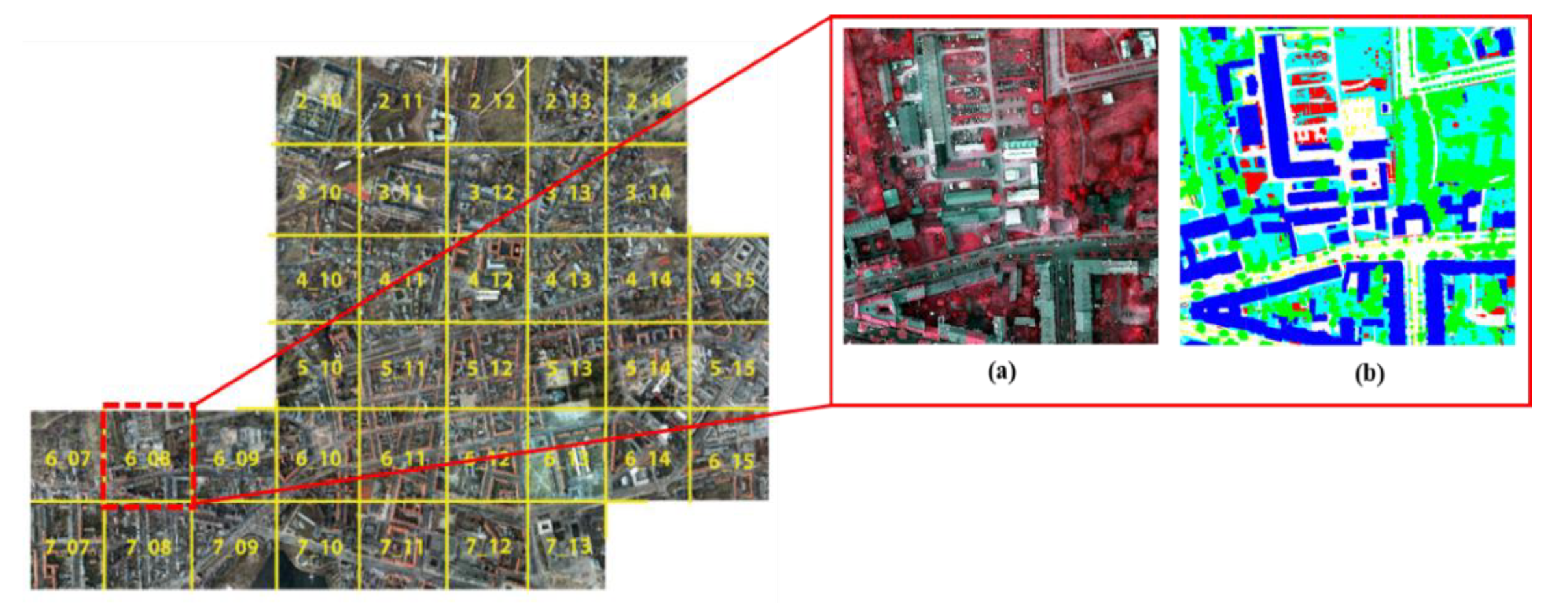
3.1. The International Society for Photogrammetry and Remote Sensing Dataset
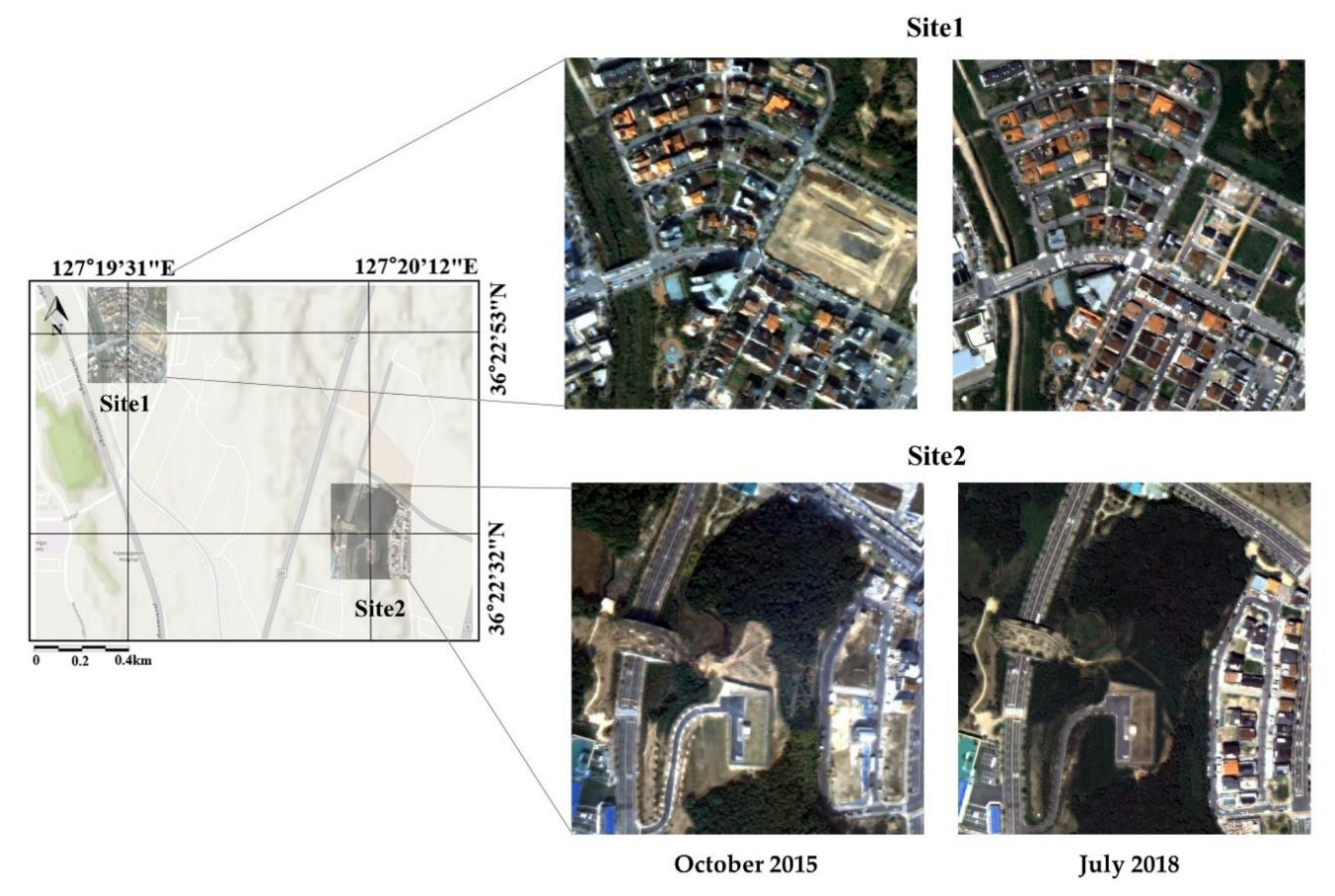
3.2. KOMPSAT 3A
4. Results
4.1. Semantic Segmentation Results
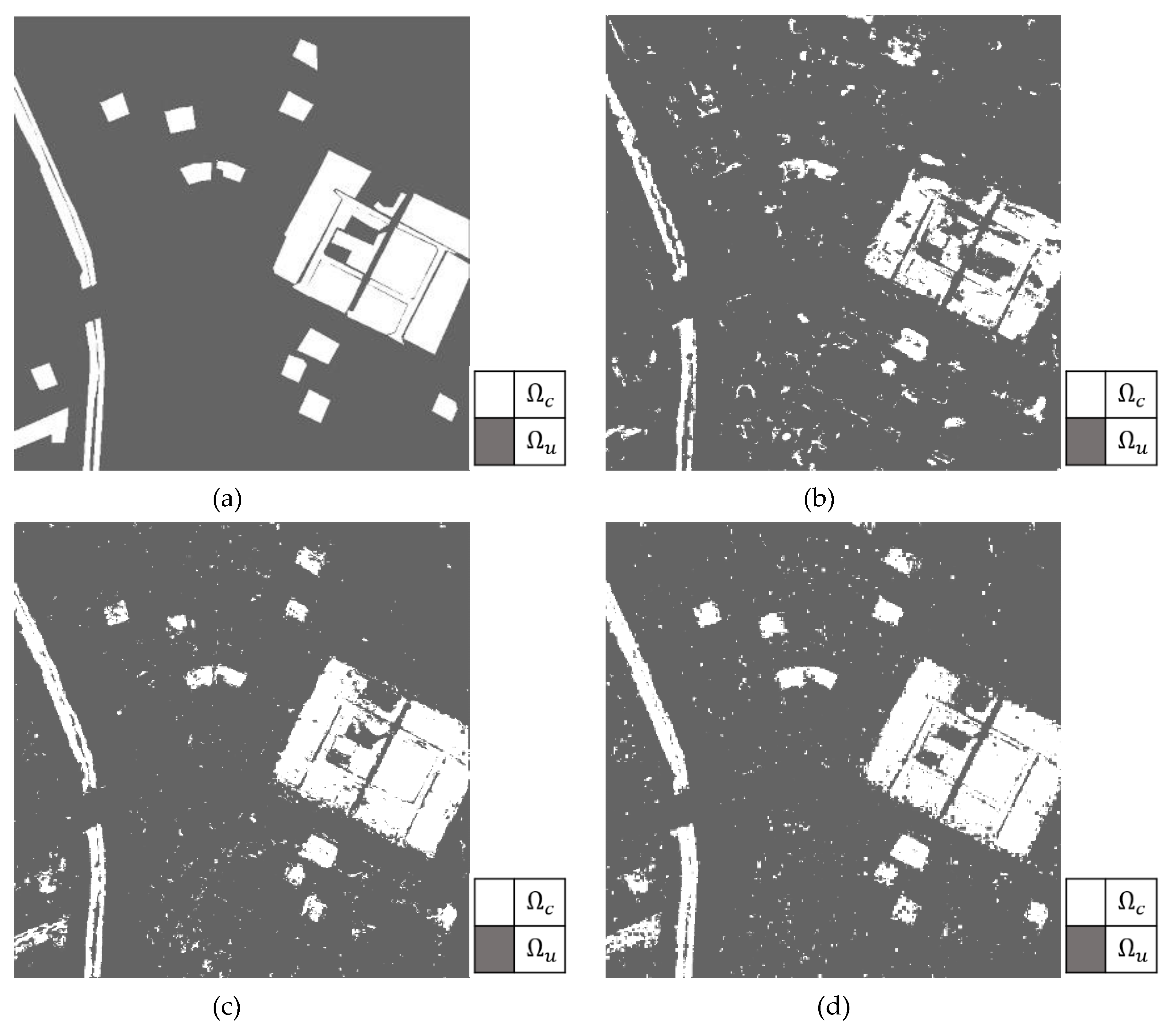
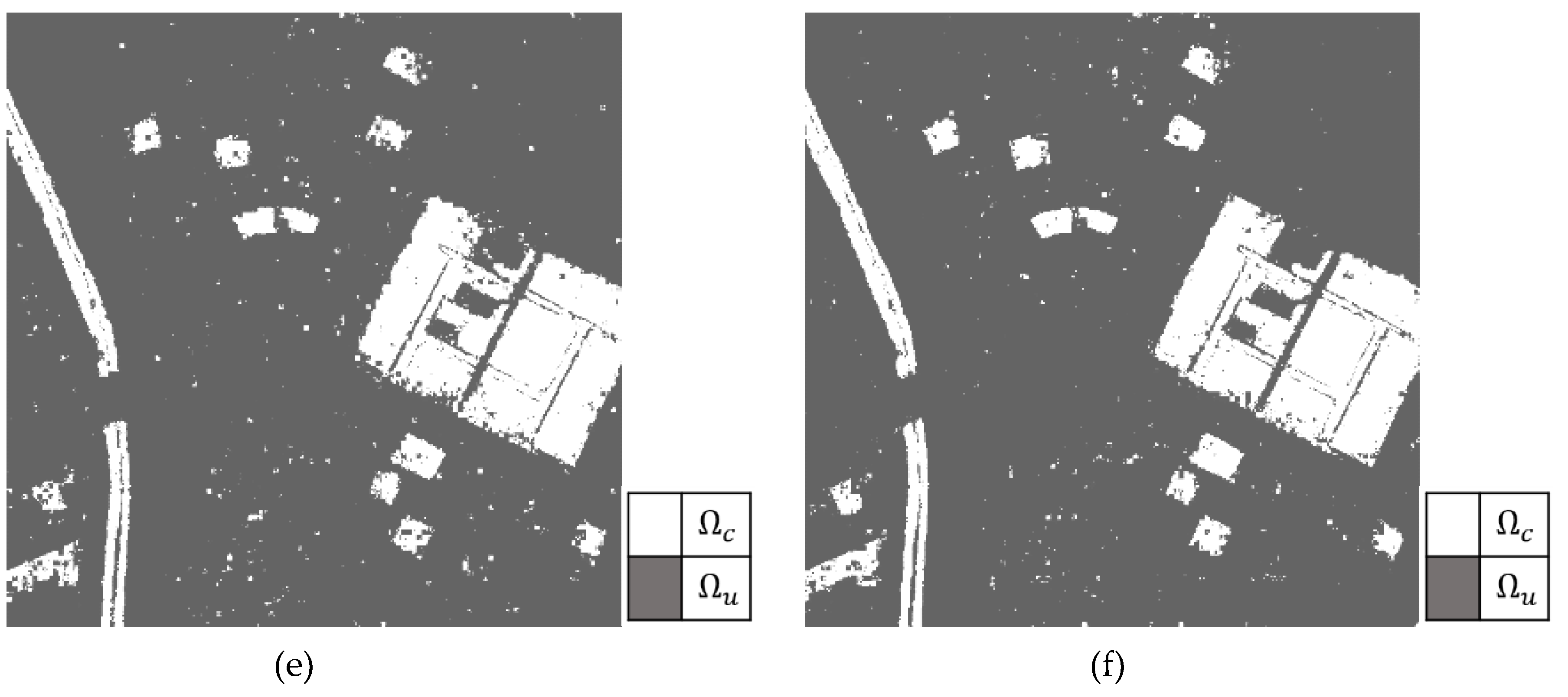
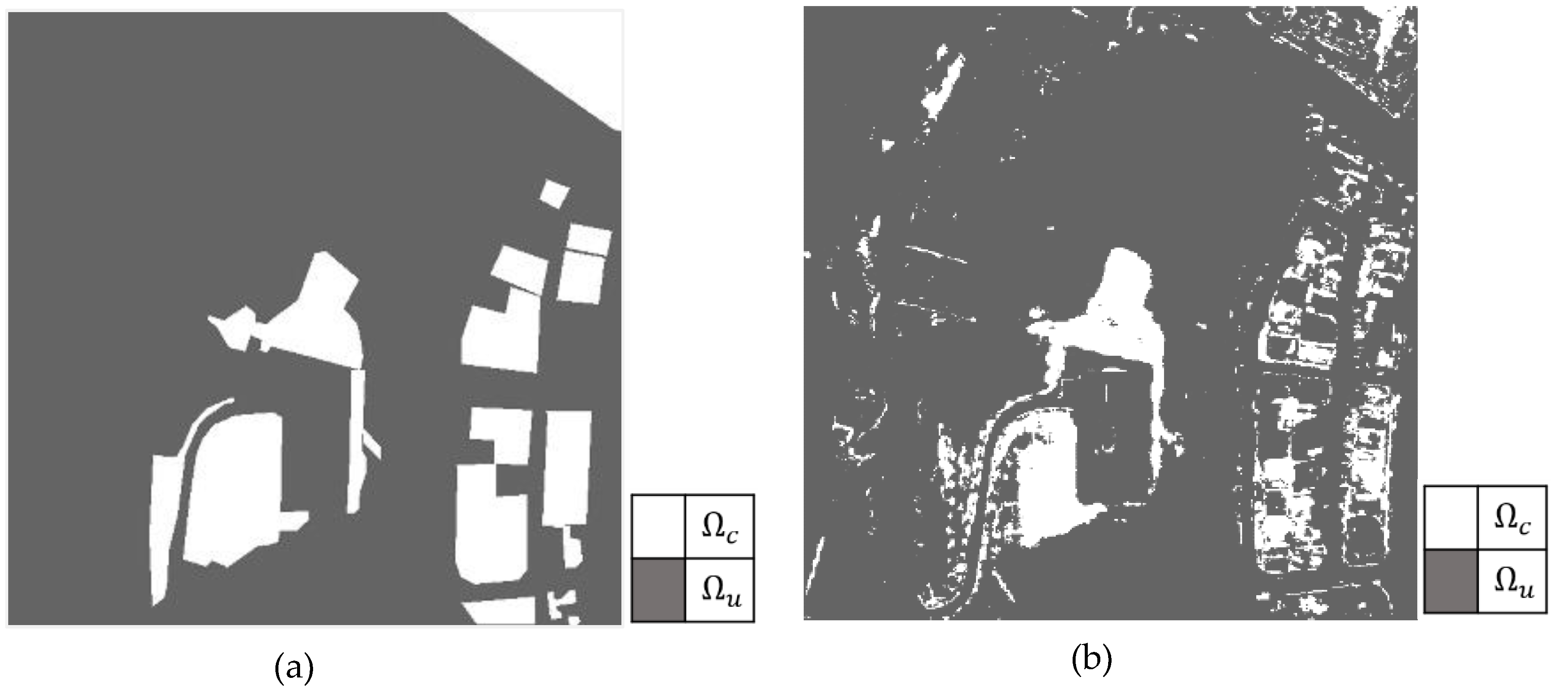
4.2. Change Detection Results
5. Discussion
5.1. Comparison with Previous Studies
5.2. The Effect of Transfer Learning
6. Conclusions
Author Contributions
Funding
Conflicts of Interest
References
- Washaya, P.; Balz, T.; Mohamadi, B. Coherence change-detection with sentinel-1 for natural and anthropogenic disaster monitoring in urban areas. Remote Sens. 2018, 10, 1026. [Google Scholar] [CrossRef] [Green Version]
- Giustarini, L.; Hostache, R.; Matgen, P.; Schumann, G.; Bates, P.D.; Mason, D.C. A change detection approach to flood mapping in urban areas using TerraSAR-X. IEEE Trans. Geosci. Remote Sens. 2013, 51, 2417–2430. [Google Scholar] [CrossRef] [Green Version]
- Brisco, B.; Schmitt, A.; Murnaghan, K.; Kaya, S.; Roth, A. SAR polarimetric change detection for flooded vegetation. Int. J. Digit. Earth 2013, 6, 103–114. [Google Scholar] [CrossRef]
- Schultz, M.; Shapiro, A.; Clevers, J.; Beech, C.; Herold, M.; Schultz, M.; Shapiro, A.; Clevers, J.G.P.W.; Beech, C.; Herold, M. Forest cover and vegetation degradation detection in the Kavango Zambezi transfrontier conservation area using BFAST monitor. Remote Sens. 2018, 10, 1850. [Google Scholar] [CrossRef] [Green Version]
- Muro, J.; Canty, M.J.; Conradsen, K.; Hüttich, C.; Nielsen, A.A.; Skriver, H.; Remy, F.; Strauch, A.; Thonfeld, F.; Menz, G. Short-term change detection in wetlands using Sentinel-1 time series. Remote Sens. 2016, 8, 795. [Google Scholar] [CrossRef] [Green Version]
- Manavalan, P.; Kesavasamy, K.; Adiga, S. Irrigated crops monitoring through seasons using digital change detection analysis of IRS-LISS 2 data. Int. J. Remote Sens. 1995, 16, 633–640. [Google Scholar] [CrossRef]
- Deng, J.; Huang, Y.; Chen, B.; Tong, C.; Liu, P.; Wang, H.; Hong, Y. A methodology to monitor urban expansion and green space change using a time series of multi-sensor SPOT and sentinel-2A images. Remote Sens. 2019, 11, 1230. [Google Scholar] [CrossRef] [Green Version]
- Khanal, N.; Uddin, K.; Matin, M.; Tenneson, K. automatic detection of spatiotemporal urban expansion patterns by fusing OSM and landsat data in Kathmandu. Remote Sens. 2019, 11, 2296. [Google Scholar] [CrossRef] [Green Version]
- Ji, C.Y.; Qinhua, L.; Sun, D.; Wang, S.; Lin, P.; Li, X. Monitoring urban expansion with remote sensing in China. Int. J. Remote Sens. 2001, 22, 1441–1455. [Google Scholar] [CrossRef]
- Singh, A. Review article digital change detection techniques using remotely-sensed data. Int. J. Remote Sens. 1989, 10, 989–1003. [Google Scholar] [CrossRef] [Green Version]
- Jeong, J. Developments of urban change detection methods according to spatial resolution of satellite images application of KOMPSAT 1 images into urban area. Geogr. J. Korea 2005, 39, 161–170, (In Korean with English Abstract). [Google Scholar]
- Dellinger, F.; Delon, J.; Gousseau, Y.; Michel, J.; Tupin, F. Change Detection for High Resolution Satellite Images, Based on SIFT Descriptors and an a Contrario Approach. In Proceedings of the IEEE Geoscience and Remote Sensing Symposium, Quebec City, QC, Canada, 13–18 July 2014; pp. 1281–1284. [Google Scholar]
- Wulder, M.A.; Ortlepp, S.M.; White, J.C.; Coops, N.C.; Coggins, S.B. Monitoring tree-level insect population dynamics with multi-scale and multi-source remote sensing. J. Spat. Sci. 2008, 53, 49–61. [Google Scholar] [CrossRef]
- Hussain, M.; Chen, D.; Cheng, A.; Wei, H.; Stanley, D. Change detection from remotely sensed images: From pixel-based to object-based approaches. ISPRS J. Photogramm. 2013, 80, 91–106. [Google Scholar] [CrossRef]
- Bindschadler, R.A.; Scambos, T.A.; Choi, H.; Haran, T.M. Ice sheet change detection by satellite image defferencing. Remote Sens. Environ. 2010, 114, 1353–1362. [Google Scholar] [CrossRef]
- Malila, W.A. Change vector analysis: An approach for detecting forest changes with Landsat. In Proceedings of the LARS Symposia, West Lafayette, IN, USA, 3–6 June 1980; p. 385. [Google Scholar]
- Deng, J.S.; Wang, K.; Deng, Y.H.; Qi, G.J. PCA-based land-use change detection and analysis using multitemporal and multisensor satellite data. Int. J. Remote Sens. 2008, 29, 4823–4838. [Google Scholar] [CrossRef]
- Niemeyer, I.; Marpu, P.; Nussbaum, S. Change detection using object features. In Object-Based Image Analysis; Springer: Berlin/Heidelberg, Germany, 2008; pp. 185–201. [Google Scholar]
- Papadomanolaki, M.; Vakalopoulou, M.; Karantzalos, K. A novel object-based deep learning framework for semantic segmentation of very high-tesolution temote sensing data: Comparison with convolutional and fully convolutional networks. Remote Sens. 2019, 11, 684. [Google Scholar] [CrossRef] [Green Version]
- Guirado, E.; Tabik, S.; Alcaraz-Segura, D.; Cabello, J.; Herrera, F. Deep-learning versus OBIA for scattered shrub detection with Google earth imagery: Ziziphus Lotus as case study. Remote Sens. 2017, 9, 1220. [Google Scholar] [CrossRef] [Green Version]
- Aguirre-Gutiérrez, J.; Seijmonsbergen, A.C.; Duivenvoorden, J.F. Optimizing land cover classification accuracy for change detection, a combined pixel-based and object-based approach in a mountainous area in Mexico. Appl. Geogr. 2012, 34, 29–37. [Google Scholar] [CrossRef] [Green Version]
- Möller, M.; Lymburner, L.; Volk, M. The comparison index: A tool for assessing the accuracy of image segmentation. Int. J. Appl. Earth Obs. 2007, 9, 311–321. [Google Scholar] [CrossRef]
- Zhang, C.; Wei, S.; Ji, S.; Lu, M. Detecting large-scale urban land cover changes from high spatial resolution remote sensing images using CNN-based classification. ISPRS Int. Geo-Inf. 2019, 8, 189. [Google Scholar] [CrossRef] [Green Version]
- Zhan, Y.; Fu, K.; Yan, M.; Sun, X.; Wang, H.; Qiu, X. Change detection based on deep siamese convolutional network for optical aerial images. IEEE Geo. Sci. Remote S. 2017, 14, 1845–1849. [Google Scholar] [CrossRef]
- Wiratama, W.; Lee, J.; Park, S.E.; Sim, D. Dual-dense convolution network for change detection of high-resolution panchromatic imagery. Appl. Sci. 2018, 8, 1785. [Google Scholar] [CrossRef] [Green Version]
- Wang, Q.; Zhang, X.; Chen, G.; Dai, F.; Gong, Y.; Zhu, K. Change detection based on Faster R-CNN for high-resolution remote sensing images. Remote Sens. Lett. 2018, 9, 923–932. [Google Scholar] [CrossRef]
- Wang, Q.; Yuan, Z.; Du, Q.; Li, X. GETNET: A general end-to-end 2-D CNN framework for hyperspectral image change detection. IEEE Trans. Geosci. Remote Sens. 2018, 57, 3–13. [Google Scholar] [CrossRef] [Green Version]
- Gong, M.; Yang, H.; Zhang, P. Feature learning and change feature classification based on deep learning for ternary change detection in SAR images. ISPRS J. Photogramm. 2017, 129, 212–225. [Google Scholar] [CrossRef]
- Lyu, H.; Lu, H.; Mou, L. Learning a transferable change rule from a recurrent neural network for land cover change detection. Remote Sens. 2016, 8, 506. [Google Scholar] [CrossRef] [Green Version]
- Geng, J.; Fan, J.; Wang, H.; Ma, X. Change Detection of Marine Reclamation Using Multispectral Images via Patch-based Recurrent Neural Network. In Proceedings of the IEEE International Geoscience and Remote Sensing Symposium, Fort Worth, TX, USA, 23–28 July 2017; pp. 612–615. [Google Scholar]
- Kong, Y.-L.; Huang, Q.; Wang, C.; Chen, J.; Chen, J.; He, D. Long Short-Term Memory Neural Networks for Online Disturbance Detection in Satellite Image Time Series. Remote Sens. 2018, 10, 452. [Google Scholar] [CrossRef] [Green Version]
- Chen, H.; Wu, C.; Du, B.; Zhang, L.; Wang, L. Change detection in multisource VHR images via deep Siamese convolutional multiple-layers recurrent neural network. IEEE Trans. Geosci. Remote Sens. 2019, 1–17. [Google Scholar] [CrossRef]
- Mou, L.; Bruzzone, L.; Zhu, X.X. Learning spectral-spatial-temporal features via a recurrent convolutional neural network for change detection in multispectral imagery. IEEE Trans. Geosci. Remote Sens. 2018, 57, 924–935. [Google Scholar] [CrossRef] [Green Version]
- Song, A.; Choi, J.; Han, Y.; Kim, Y. Change detection in hyperspectral images using recurrent 3d fully convolutional networks. Remote Sens. 2018, 10, 1827. [Google Scholar] [CrossRef] [Green Version]
- Fu, G.; Liu, C.; Zhou, R.; Sun, T.; Zhang, Q. Classification for high resolution remote sensing imagery using a fully convolutional network. Remote Sens. 2017, 9, 498. [Google Scholar] [CrossRef] [Green Version]
- Li, Y.; Zhang, H.; Xue, X.; Jiang, Y.; Shen, Q. Deep learning for remote sensing image classification: A survey. Data Min. Knowl. Disc. 2018, 8, e1264. [Google Scholar] [CrossRef] [Green Version]
- Liang, Y.; Monteiro, S.T.; Saber, E.S. Transfer Learning for High Resolution Aerial Image Classification. In Proceedings of the IEEE Applied Imagery Pattern Recognition Workshop, Washington, DC, USA, 18–20 October 2016; pp. 1–8. [Google Scholar]
- Sinno, J.P.; Qiang, Y. A survey on transfer learning. IEEE Trans. Knowl. Data Eng. 2009, 22, 1345–1359. [Google Scholar]
- Song, A. A Novel Deep Learning Framework for Multi-Class Change Detection of Hyperspectral Images. Ph.D. Thesis, Seoul National University, Seoul, Korea, February 2019. [Google Scholar]
- Lee, H.; Kwon, H. Going deeper with contextual CNN for hyperspectral image classification. IEEE Trans. Image Process. 2017, 26, 4843–4855. [Google Scholar] [CrossRef] [PubMed] [Green Version]
- Yuan, Q.; Wei, Y.; Meng, X.; Shen, H.; Zhang, L. A multiscale and multidepth convolutional neural network for remote sensing imagery pan-sharpening. IEEE J. Sel. Top. Appl. 2018, 11, 978–989. [Google Scholar] [CrossRef] [Green Version]
- Gong, Z.; Zhong, P.; Yu, Y.; Hu, W.; Li, S. A CNN with multiscale convolution and diversified metric for hyperspectral image classification. IEEE Trans. Geosci. Remote Sens. 2019, 57, 3599–3618. [Google Scholar] [CrossRef]
- Liang, M.; Jiao, L.; Yang, S.; Liu, F.; Hou, B.; Chen, H. Deep multiscale spectral-spatial feature fusion for hyperspectral images classification. IEEE J. Sel. Top. Appl. 2018, 11, 2911–2924. [Google Scholar] [CrossRef]
- Liao, W.; Wang, X.; An, D.; Wei, Y. Hyperspectral Imaging Technology and Transfer Learning Utilized in Haploid Maize Seeds Identification. In Proceedings of the International Conference on High Performance Big Data and Intelligent Systems, Shenzhen, China, 9–11 May 2019; pp. 157–162. [Google Scholar]
- Xingjian, S.H.I.; Chen, Z.; Wang, H.; Yeung, D.Y.; Wong, W.K.; Woo, W.C. Convolutional LSTM network: A machine learning approach for precipitation nowcasting. Adv. Neur. Inf. 2015, 802–810. [Google Scholar]
- Landis, J.R.; Koch, G.G. The measurement of observer agreement for categorical data. Biometrics 1977, 33, 159–174. [Google Scholar] [CrossRef] [Green Version]
- ISPRS WG III/4. ISPRS 2D Semantic Labeling Contest. Available online: http://www2.isprs.org/commissions/comm3/wg4/semantic-labeling.html (accessed on 16 January 2020).
- Acharya, T.; Yang, I.; Lee, D. Land cover classification using a kompsat-3a multi-spectral satellite image. Appl. Sci. 2016, 6, 371. [Google Scholar] [CrossRef] [Green Version]
- Choi, J.; Kim, G.; Park, N.; Park, H.; Choi, S. A hybrid pansharpening algorithm of high spatial resolution satellite images that employs injection gains based on NDVI to reduce computational costs. Remote Sens. 2017, 9, 976. [Google Scholar] [CrossRef] [Green Version]
- ArcGIS Webmap. Available online: https://www.arcgis.com/home/webmap/viewer.html (accessed on 16 January 2020).


| Patch Numbers | |
|---|---|
| Potsdam dataset | 2_10, 2_11, 2_12, 3_10, 3_11, 3_12, 4_10, 4_11, 4_12, 5_10, 5_11, 5_12, 6_7, 6_8, 6_9 6_10, 6_11, 6_12, 7_7, 7_8, 7_9, 7_10, 7_11, 7_12 |
| Filter Shape | F1 Score | OA | ||||
|---|---|---|---|---|---|---|
| Impervious Surface | Building | Low Vegetation | Tree | Car | ||
| ) | 0.7770 | 0.8306 | 0.5817 | 0.4703 | 0.4589 | 0.7532 |
| 0.8745 | 0.9088 | 0.6775 | 0.7370 | 0.6733 | 0.8427 | |
| 0.8365 | 0.8696 | 0.6057 | 0.6040 | 0.6419 | 0.8134 | |
| 0.8386 | 0.8611 | 0.6121 | 0.6263 | 0.6855 | 0.7842 | |
| 0.9048 | 0.9231 | 0.7431 | 0.7819 | 0.7895 | 0.8717 | |
| Change Detection Methods | OA | Kappa | F1 Score |
|---|---|---|---|
| LSTM | 0.9136 | 0.6386 | 0.6876 |
| 2DCNN-LSTM | 0.9597 | 0.8443 | 0.8680 |
| Re3FCN | 0.9674 | 0.8984 | 0.8978 |
| Multiscale Re3FCN without TL | 0.9717 | 0.8923 | 0.9090 |
| Multiscale Re3FCN with TL | 0.9790 | 0.9201 | 0.9326 |
| Change Detection Methods | OA | Kappa | F1 Score |
|---|---|---|---|
| LSTM | 0.8826 | 0.5350 | 0.6010 |
| 2DCNN-LSTM | 0.9565 | 0.8518 | 0.8783 |
| Re3FCN | 0.9633 | 0.8766 | 0.8990 |
| Multiscale Re3FCN without TL | 0.9759 | 0.9158 | 0.9304 |
| Multiscale Re3FCN with TL | 0.9795 | 0.9288 | 0.9412 |
© 2020 by the authors. Licensee MDPI, Basel, Switzerland. This article is an open access article distributed under the terms and conditions of the Creative Commons Attribution (CC BY) license (http://creativecommons.org/licenses/by/4.0/).
Share and Cite
Song, A.; Choi, J. Fully Convolutional Networks with Multiscale 3D Filters and Transfer Learning for Change Detection in High Spatial Resolution Satellite Images. Remote Sens. 2020, 12, 799. https://doi.org/10.3390/rs12050799
Song A, Choi J. Fully Convolutional Networks with Multiscale 3D Filters and Transfer Learning for Change Detection in High Spatial Resolution Satellite Images. Remote Sensing. 2020; 12(5):799. https://doi.org/10.3390/rs12050799
Chicago/Turabian StyleSong, Ahram, and Jaewan Choi. 2020. "Fully Convolutional Networks with Multiscale 3D Filters and Transfer Learning for Change Detection in High Spatial Resolution Satellite Images" Remote Sensing 12, no. 5: 799. https://doi.org/10.3390/rs12050799
APA StyleSong, A., & Choi, J. (2020). Fully Convolutional Networks with Multiscale 3D Filters and Transfer Learning for Change Detection in High Spatial Resolution Satellite Images. Remote Sensing, 12(5), 799. https://doi.org/10.3390/rs12050799