Article

Turbidity Estimation from GOCI Satellite Data in the Turbid Estuaries of China’s Coast

1
College of Agricultural Engineering, Hohai University, Nanjing 210098, China
2
State Key Laboratory of Hydrology-Water Resources and Hydraulic Engineering, Nanjing 210098, China
3
School of Marine Sciences, Nanjing University of Information Science and Technology, Nanjing 210044, China
4
Faculty of Social Science and Asia Pacific Studies Institute, Chinese University of Hong Kong, Hong Kong
*
Author to whom correspondence should be addressed.
Remote Sens. 2020, 12(22), 3770; https://doi.org/10.3390/rs12223770
Submission received: 12 October 2020 / Revised: 13 November 2020 / Accepted: 14 November 2020 / Published: 17 November 2020
(This article belongs to the Special Issue Coastal Environments and Coastal Hazards)

Abstract

:
Knowledge of the distribution and variation of water turbidity directly represent important information related to the marine ecology and multiple biogeochemical processes, including sediment transport and resuspension and heat transfer in the upper water layer. In this study, a neural network (NN) approach was applied to derive the water turbidity using the geostationary ocean color imager (GOCI) data in turbid estuaries of the Yellow River and the Yangtze River. The results showed a good agreement between the GOCI-derived turbidity and in situ measured data with a determination coefficient (R2) of 0.84, root mean squared error (RMSE) of 58.8 nephelometric turbidity unit (NTU), mean absolute error of 25.1 NTU, and mean relative error of 34.4%, showing a better performance than existing empirical algorithms. The hourly spatial distributions of water turbidity in April 2018 suggested that high turbidity regions were distributed in the Yellow River estuary, Yangtze River estuary, Hangzhou Bay, and coastal waters of Zhejiang Province. Furthermore, the relationship between water turbidity and tide were estimated. A defined turbid zone was defined to evaluate the diurnal variations of turbidity, which has subtle changes at different times. Our results showed an inverse relationship between turbidity and tide over six selected stations, i.e., when the value of turbidity is high, then the corresponding tidal height is usually low, and vice versa. The combined effects of tidal height and tidal currents could explain the phenomena, and other factors such as winds also contribute to the turbidity distributions.

Graphical Abstract

1. Introduction

Water turbidity is an important proxy for monitoring water quality and can reflect the integrated optical properties of water conditions [1,2]. In addition, turbidity is widely used to indicate the total suspended matter (TSM) and optical parameters [3,4]. Therefore, it is of great importance to obtain reliable and space-distributed observation of water turbidity to improve our understanding of the biogeographic dynamic of the estuarine system. Turbidity is a water-quality parameter that can be derived from remote sensing data. It is strongly related to TSM concentration. The underlying physical process for measuring suspended particle via turbidity is that particles causes scatter of light which is proportional to the TSM in the waters. Turbidity is thus a measure of the loss of light transparency in the near-infrared (860 nm) caused by the suspended particles. Measuring TSM gravimetrically is a rather time-consuming process and turbidity measured in situ is an efficient and cost-effective way to measure the influence of suspended particles in the estuaries. However, the required observations of water turbidity over a wide range of temporal and spatial scales are limited by the traditional methods at fixed geographical locations with fixed intervals. Ideally, satellite remote sensing technology in this context is very advantageous and potentially allows overcoming the spatiotemporal limitations of traditional measurements, providing an ideal opportunity for investigating water turbidity.
Recently, remote sensing has been applied to map water turbidity on both global and regional scales [5], and some methods for turbidity mapping have been designed using in situ data and satellite data [6,7,8,9]. Most of the algorithms for retrieval of turbidity rely on a good relationship between water turbidity and reflectance signal, especially in the red spectrum [10,11]. For instance, Choubey [10] found that a good correlation between the red band (620–680 nm) and turbidity within 15–45 nephelometric turbidity unit (NTU) in the Tawa reservoir, India. Nechad et al. [2] designed a generic single-band algorithm for turbidity estimation from reflectance in the coastal waters. He et al. [9] developed an empirical model for retrieving TSM using a two-band ratio (745 and 490 nm) of geostationary ocean color imager (GOCI) remote sensing reflectance (Rrs) data and thereby designed a good linear relationship between turbidity and TSM in the Hangzhou Bay. In these algorithms, atmospheric correction (AC) is also crucial to retrieve the turbidity accurately, however, the standard AC based on near-infrared (NIR) bands (NIR-AC) for turbid estuaries is often difficult. These suspended particulate matter (SPM) models are wildly applied for turbidity estimations with some alternative AC approaches. Some studies have used Rayleigh-corrected reflectance (Rrc) instead of the widely used Rrs signal. For instance, Qiu et al. [12] proposed an innovative empirical algorithm using Rrc(λ) observations from geostationary ocean color imager (GOCI) two bands (490 and 680 nm) to map turbidity in the Zhejiang coastal area. The literature on the estimation of turbidity from remote sensing is quite developed, but few studies concern the response of the marine environment (e.g., winds, riverine discharges, tides) to the spatial and temporal variations of water turbidity in shallow coastal areas, such as lagoons and estuaries (e.g., [9,13,14,15]).
Note that much of the previous literature concerns empirical algorithms and models, which attempt to link the observed turbidity to the satellite remote sensing signal. The disadvantages of these remote sensing approaches are that they may not be useful for general application to an estuarine region with highly turbid water because they depend on the specific data and oceanic conditions under which they are calibrated. One reason is the existing AC will bring uncertainties over the turbid estuary. Another reason is that the simple empirical relationships used in the previous algorithms will not work well in the turbid estuary. More complex links should be considered. Compared to the conventional ocean color modeling process dependent on accurate AC and empirical relationships, the non-linear relationships modeled by the neural network (NN) show great advantages.
Moreover, existing contributions to the literature usually lack a detailed analysis of the relationship between water turbidity and tide in the turbid estuary. This information, on the contrary, is extremely important when the mechanism of variation in water turbidity is analyzed to advance our understanding of the geomorphic dynamics of shallow coastal areas. As the first geostationary ocean color satellite sensor, GOCI can collect remotely sensed data during every daylight hour, acquiring the turbidity observation networks at a high temporal resolution for discussing the relationship between turbidity and tide over one day.
This study is focused on highly turbid estuaries of China’s coast. The Yellow River estuary, the Yangtze River estuary, and Hangzhou Bay are typical areas to estimate the relationships between turbidity with other biogeochemical and physical factors. One reason is that these estuaries are so turbid due to the Yellow River and the Yangtze River, one of the most sediment-laden rivers in the world. Another reason is the complex hydrology in the estuaries. In the Yellow River estuary, the highest current speed was found outside of the mouth of the Yellow River, and current speeds decreased southward and northward. The contour lines of current speeds were configured in the shape of an ellipse and current speeds declined more quickly on the coast than offshore [16]. The Yangtze River estuary is a complex estuary with three branches and four inlets into the sea, under the strong action between river runoffs and tidal currents. The hydrodynamic environment of each channel is also different, which results in the highly dynamic variation in the spatial and temporal distribution of TSM concentration.
A large number of in situ measurements and concurrent GOCI images were acquired. In virtue of the complexity and character of the turbid estuaries, the turbidity is hardly accurately approximated by a linear function of input variables. In this study, a classic machine-learning algorithm named NN was used to estimate water turbidity from at-satellite Rrc data. Then, combined with the numerical simulation of tidal information, this study analyzed the relationship between turbidity and tide and investigated the response of turbidity pattern to tidal action.

2. Materials and Methods

2.1. Study Areas

The study area included two separate regions with highly turbid waters (black boxes in Figure 1a), including the Yellow River Estuary (Figure 1b), the Yangtze River Estuary, and Hangzhou Bay (Figure 1c). These two estuaries are major commercial arteries and industrial centers in China [17]. As a large river, the Yellow River discharge 1.1 × 10⁹ tons of sediments annually to the Bohai Sea. This huge amount of sediment plays an important role in affecting the balance of sedimentary and ecological environments in the Bohai Sea [17,18]. The Yangtze River Estuary and Hangzhou Bay are significantly influenced by sediment flow from the Yangtze River and Qiangtang River. The Yangtze River, the longest river in China, discharges approximately 2.4 × 10⁸ tons of sediment into the East China Sea annually [19]. Additionally, the Qiantang River also directly provides large quantities of freshwater high in sediments and nutrients into the Hangzhou Bay and Zhejiang coastal region [20]. Hangzhou Bay is one of the strongest tidal bays in the world. The typically strong tidal action in the Zhejiang coastal region is one of the major factors affecting significantly the resuspension of sediment.

2.2. Dataset

2.2.1. In Situ Measurements

In situ measurements of turbidity used were obtained from two resources: cruise collection and buoy observation (Figure 1a). It should be noted that the turbidity measurements, covering a variety of hydrological and marine environments, were used for improving the stability and robustness of the used neural network approach in turbidity estimation, although some observation regions in this work were beyond our study areas, i.e., the Yellow River and Yangtze River estuaries including Hangzhou Bay.
(1) Cruise Data Collection
Turbidity was obtained from water samples collected using nine cruises in the Bohai Sea and the Yellow Sea. These cruises were conducted in different seasons, including June 2011, November 2011, November 2013, April 2014, August 2015, July 2016, December 2016, April 2018, and July 2018. The turbidity data at each sampling station were measured using the Seapoint turbidity sensor mounted to the Seabird SBE19plus CTD (Seabird Electronics, Bellevue, Washington), and was collected round-the-clock at an interval of 1–2 h In total, the in situ turbidity dataset for cruise collection included 825 samples.
(2) Continual Buoy Observation
In this study, 21 buoys were used to collect the turbidity measurements. These buoys were mainly distributed in the coastal waters of Zhejiang Province and Jiangsu Province (Figure 1a). Among these buoys, eleven buoys were located in the coastal areas of Zhejiang Province (hereafter called ZJ buoy). Nine buoys were placed in the Qingcaosha Reservoir nearby the Yangtze River Estuary (hereafter called SK buoy), and the other one buoy moored in the Sheyang observation station in the north of Jiangsu Coastal area (hereafter called JS buoy). Continual observations of turbidity were collected from the ZJ buoys during January, November, and December 2014 with a measured frequency of 15 min. Meanwhile, turbidity measurements from JS buoy for January–April 2015 and SK buoy for May 2016 were used in this study.
To assure the data quality, the above-mentioned in situ turbidity dataset was quality controlled according to Qiu et al. [12]. The measurements with low quality/precision were removed according to the visual inspection of the turbidity time series based on the mean and standard deviation. The remaining high-quality field data were selected to match the satellite data for model development and validation.

2.2.2. Satellite Data

High-frequency observations several times per day will advance our understanding of the turbidity in estuaries. The geostationary platform can examine a region and acquire a sufficient SNR to retrieve ocean reflectance under low light conditions (early morning and late afternoon) and at high viewing angles, which can also maximize daily spatial coverage resulting from diurnal variability in cloud cover and orbital coverage gaps. Therefore, a greater understanding of short-term dynamics in estuaries will be achieved from sensors on geostationary platforms. The GOCI is currently the only geostationary sensor available over the estuaries in China with the waveband settings similar to those mainstream ocean color sensors, such as MODIS.
GOCI Level-1B data used in this study were provided by the Korea Ocean Satellite Center (KOSC, http://kosc.kiost.ac.kr/). The GOCI sensor onboard Communication, Ocean, and Meteorological Satellite (COMS), as the first ocean color geostationary satellite sensor, was launched by South Korea on 26 June 2010. GOCI provides satellite images at hourly intervals up to eight times daylight from 0:15 to 07:45 GMT, enabling near real-time and hourly monitoring of ocean properties in northeast Asia [21]. The GOCI images have a spatial resolution of 500 m and eight spectral bands (412, 443, 490, 555, 660, 680, 745, and 865 nm). The GOCI Level-1B images were geometric and radiometrically corrected using the GOCI data processing system (GDPS) software [21,22]. Thereafter, we used the approach established by Wang and Gordon [23] in GDPS to obtain Rrc data. Meanwhile, the GOCI Rrs data were also calculated by using the UV-AC algorithm proposed by He et al. [9]. These Rrs data were used in some previously published algorithms, which were based on Rrs, for assessing the performance of the NN approach (see details in Section 2.3.1).
This study attempted to apply the neural network approach in estimating turbidity directly from the Rrc signal. Therefore, the satellite-field matchup dataset of Rrc was established by matching the GOCI Rrc images with in situ measured turbidity. To ensure the quality of the satellite matchup dataset, the following rules were used in this procedure [24]: (i) the matchup dataset included GOCI data with a temporal window within ±6h for cruise observations and within ±20 min for buoy collections; (ii) the average value for spatial windows of 3 × 3 pixels centered on the sampling station coordinate defined the final matching value, reducing the effect of outliers; (iii) negative matching Rrc values were removed from the matchup dataset. Following these above rules, the number of 636, 220, 283, and 231 satellite-field matchups with coincident measured turbidity for the observation dataset of ZJ buoy, JS buoy, SK buoy, and cruise were available in this study, respectively.
Additionally, to discuss the relationship between the turbidity pattern and tide, a total of 48 GOCI images with low cloud-cover were selected according to tidal observation information for the Yellow River and Yangtze River Estuaries. Table 1 summarized the coverage and overpass time of these selected GOCI images and their corresponding tidal information.

2.3. Methods

2.3.1. Neural Network Approach for Retrieving Turbidity

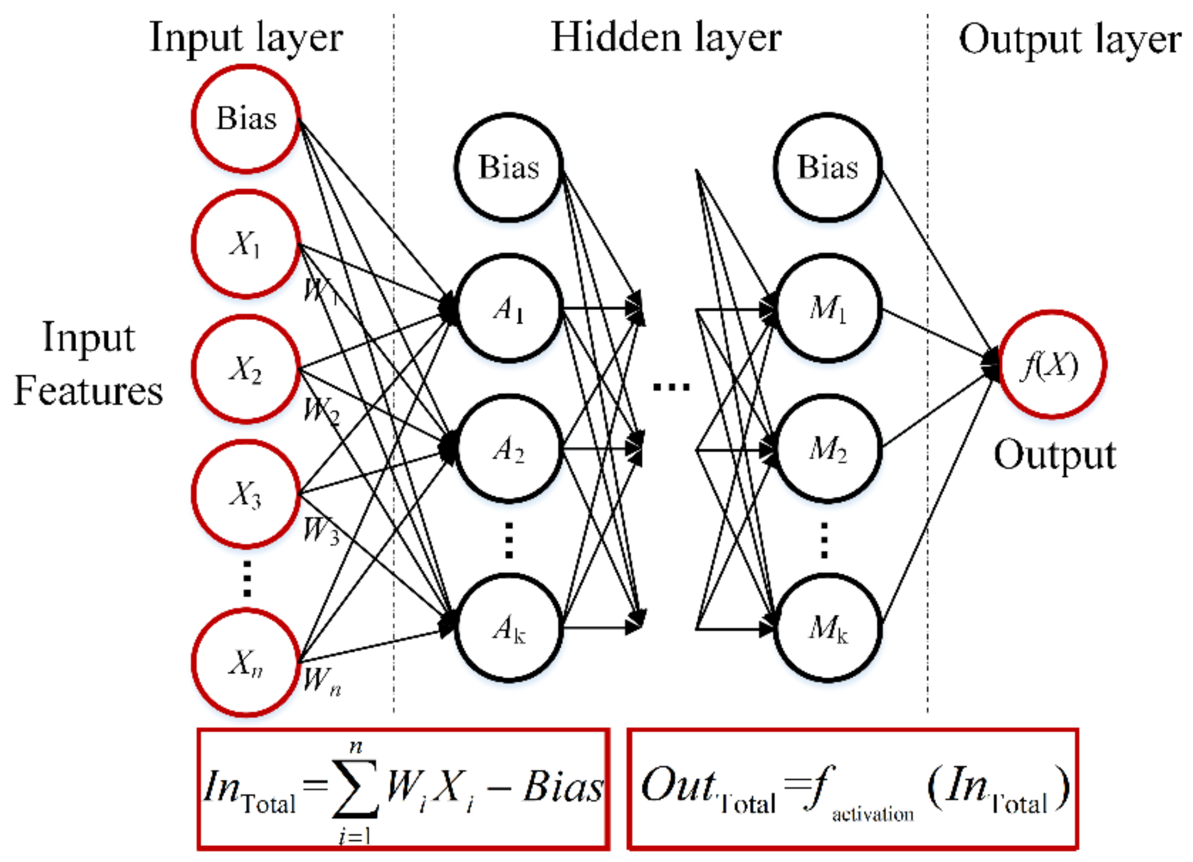
Neural network is an empirical method that usually needs a priori knowledge or trial and error to define its topological structure that commonly known as an artificial neural network [25]. Figure 2 illustrates the standard network topology of a feed-forward NN model, including one input layer, one or more hidden layers, and one output layer. Generally, nodes (or neurons) in the input layer serve as the input feature vector X, whose signals are processed by different synaptic weights W and Bias. Then, those processed signals, i.e., InTotal, are further restricted by a nonlinear relationship named activation function factivation before sending them to the following nodes in subsequent layers as OutTotal. Such signals flow in a NN model move forwardly node-by-node and layer-by-layer as a full connection fashion, which makes it more efficacious to deal with different problems. As a result, in the remote sensing field, there has published a large number of papers introducing their custom NN models to retrieve optical or biophysical parameters of water or land surface [26,27,28,29,30].
In this study, Rrc(λ) data at 490, 555, and 680 nm were selected as the input variables, while turbidity would be taken as the only output parameter. Rrc(680) has been proven to have a strong correlation with turbidity [5,12]. In addition, spectral data at blue (Rrc(490)) and green (Rrc(555)) bands were also included to represent the contributions of predominant components in the water column like TSM and Chlorophyll-a. Considering that both the design of the model structure and training strategy have a great impact on the final performance, here, the most commonly used back-propagation (BP) algorithm [31] was applied to optimize our NN model. Through trial and error, several different structures of the hidden layer were evaluated based on independent validation data to avoid overfitting problem and then confirmed the optimal hidden network (see details in Section 3.2). The sigmoid function was chosen as the activation function, and W and bias were initialized randomly for each node or layer. For convenience, the NN model was constructed and tuned using the machine learning package embedded in MATLAB (version R2017b, MathWorks) software.
Additionally, we compared the turbidity estimation acquired by the NN method with another three published models (see details in Table 2), to further examine the performance of the NN approach in our work. It should be noted that these published models with their original coefficients were only used to better assess the accuracy of the turbidity estimation in our study, although they may not depend on the condition like our study area. For Model C [32], the bbp,555 was estimated using the quasi-analytical algorithm (QAA) algorithm proposed by Lee et al. [33].

2.3.2. Numerical Simulation of Tiding Information

We used the 3D numerical model Regional Ocean Modeling System (ROMS) to determine tidal fields. ROMS is a free surface, terrain-following, primitive equation ocean model widely used by the scientific community for a diverse range of applications (e.g., [34,35]).
The air–sea interaction boundary layer is based on the National Centers for Environmental Prediction (NCEP) reanalysis and related datasets (Climate Forecast System Version 2, CFSV2, https://rda.ucar.edu/datasets/ds094.0). The CFSV2 data were provided once per 6 h with spatial resolutions 1º × 1º. The boundary conditions are from the results of the HYbrid Coordinate Ocean Model (HYCOM, https://www.hycom.org/data/glbu0pt08/expt-91pt2).
The research areas are in the range of 23.7–41.3°N, 117.5–132.5°E. We ran the ROMS for the whole of 2018. In the model, the orthogonal curvilinear coordinates on a staggered Arakawa C grid is used with a horizontal mesh of 5′ and a stretched terrain-following coordinate system with 32 vertical levels. Turbulence closure in the vertical direction is achieved through the K-profile surface layer parameterization.

2.4. Evaluation Matrix

The accuracy of satellite-derived turbidity was assessed by calculating several statistical indicators between the derived and measured data, including the Pearson correlation coefficient (R), root mean squared error (RMSE), mean absolute error (MAE), and mean relative error (MRE). These indicators were defined as follows:
R M S E = 1 n i = 1 n x d x m 2
M R E = 1 n i = 1 n x d x m x m × 100 %
where xm and xd are the measured and derived value, respectively; n is the total number of samples.

3. Results

3.1. Variation of In Situ Turbidity Data

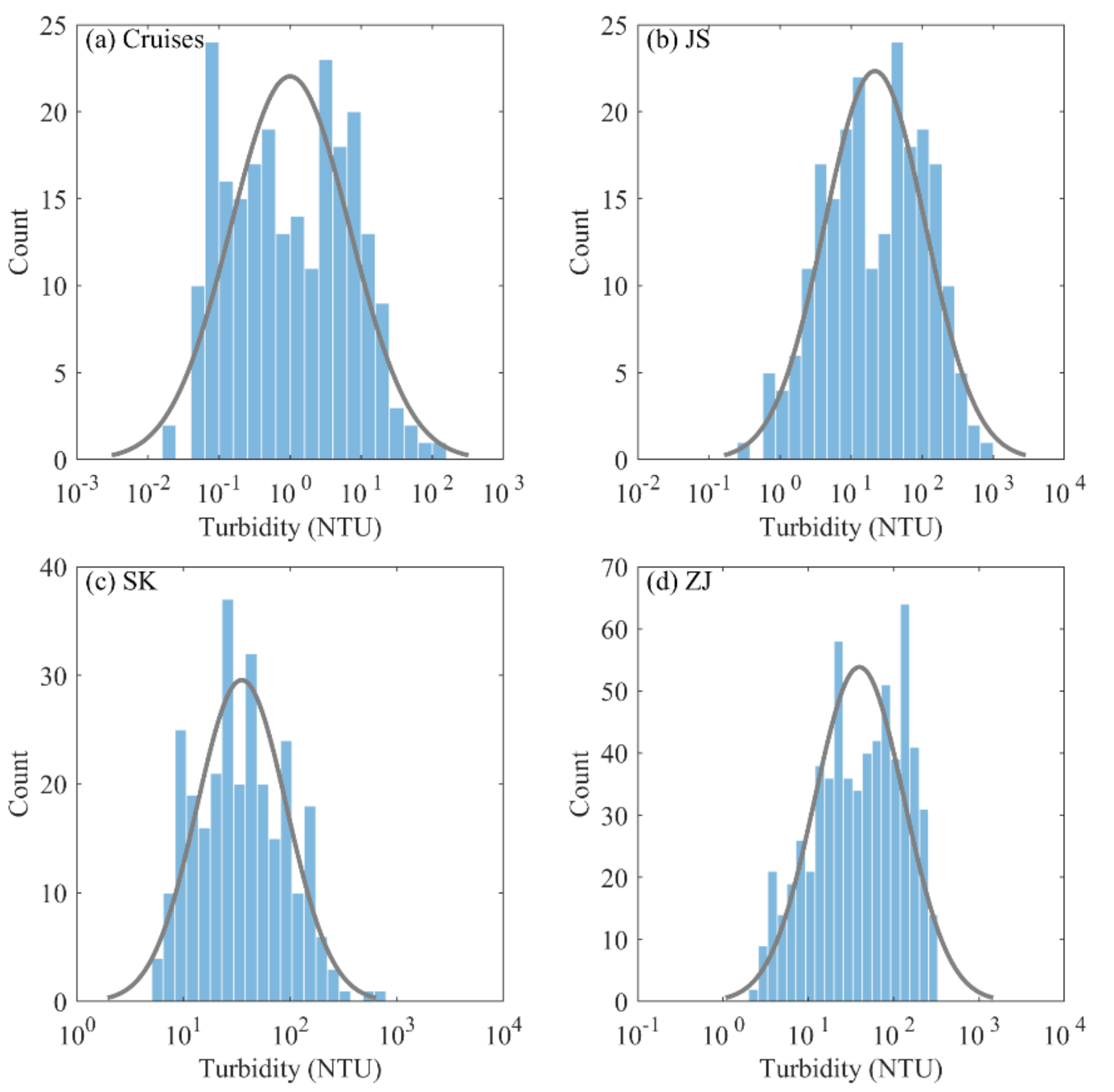
The histograms of the turbidity measurements in the satellite-field matchup dataset are shown in Figure 3, and the basic statistical attributes are listed in Table 3. In general, the turbidity observations from the cruise samples (Figure 3a), JS buoy (Figure 3b), SK buoy (Figure 3c), and ZJ buoy (Figure 3d) were distributed approximately log-normally and varied widely with CV values of 218%, 166%, 132%, and 99%, respectively. For cruises collection, the values of turbidity observation varied from 0.02 to 100.79 NTU, with a mean of 4.66 NTU. The majority of turbidity data were smaller than 20 NTU (Figure 3a). The turbidity value for the JS buoy was from about 0.3 to 976 NTU with a mean value of 64.45 NTU, and the majority fell within 15–250 NTU (Figure 3b). The turbidity data for the SK buoy were located within 5.09–791.41 NTU, with a mean value of 57.41 NTU. For the ZJ buoy (Figure 3d), the majority of samples fell with 20–250 NTU. Figure 3 shows that the turbidity values from cruises collection were relatively lower compared to buoy collection. This was because cruises samples were distributed in both coastal water and clear water away from the coast, however, the buoys were located in turbid coastal waters.

3.2. Development and Validation of the NN Model

In this study, the satellite-field matchup dataset including in situ turbidity and at-satellite Rrc(λ) data (N = 1370) were randomly divided into two subsets: (1) one subset contained 70% of the full dataset (N = 959) and was used for model calibration; (2) one subset contained 30% of full dataset (N = 411) and was used for model validation. Figure 4 shows that the turbidity of the calibration dataset and validation dataset included both low and high values.
Following the procedure of the NN approach described in Section 2.3.1, the 959 pairs of Rrc(λ) (λ = 490, 555, and 680 nm) data and in situ turbidity data were used for developing the NN model. Model performances for different network configurations were investigated based on the testing data. The number of hidden layers ranged from one to three with a minimum of five nodes up to a maximum of 30 nodes for each layer at an interval of five. The training of each NN model was repeated 10 times. The result indicated that there was no noteworthy improvement in model precision with the increase of network complexity. The average value of RMSE was about 53.4 ± 0.7 NTU. For simplicity, the hidden network was determined as one layer with 10 neurons.
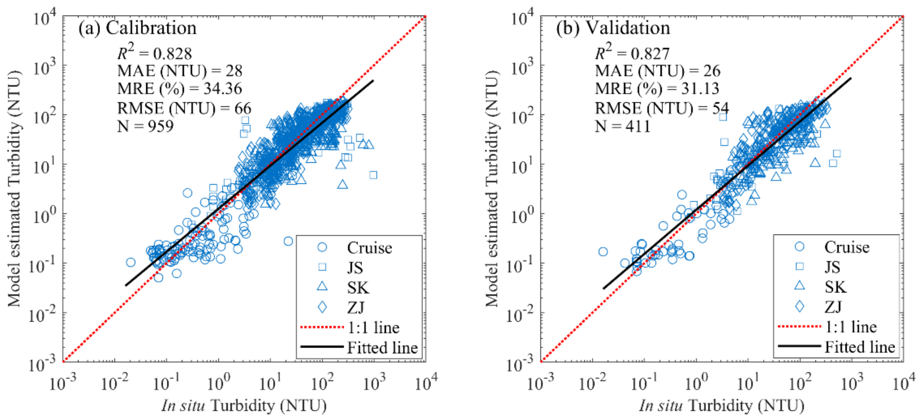
Figure 5a shows the strong linear relationship between the satellite-derived and in situ turbidity results, with R2, MAE, MRE, and RMSE values of 0.828, 28.0 NTU, 34.36%, and 66.0 NTU, respectively. The samples were close to the 1:1 line. Following calibration, the NN model was validated using the validation dataset (N = 411) to assess the performance of the model. The scatter plot comparing the in situ measured and modeled turbidity values are shown in Figure 5b. Remarkably, the NN approach showed encouraging results. The estimated turbidity from Rrc(λ) data agreed well with the in situ measured turbidity, with R2, MAE, MRE, and RMSE values of 0.827, 26.0 NTU, 31.13%, and 54.0 NTU, respectively.
Additionally, to further examine the performance of the NN approach in this work, the NN approach was compared with the other three existing models (Table 2) using the validation data. Note that the original Model A, Model B, and Model C have the calibrated model coefficients using their own in situ data. In this study, we do not have enough in situ data to recalibrate the models because the only turbidity was collected in so many stations. Generally, the models are not applied to other regions directly if not recalibrated. However, to evaluate the performance of the NN model, we compared the NN results with the three models. As a result of the use of Rrs data, the valid sample number decreased from 411 to 253. Table 4 exhibits the performance comparison of four models. The NN approach showed the best performance, with higher R2 value and lower MAE, MRE, and RMSE values compared to the other models. For Model A [12], the R2, MAE, MRE, and RMSE values were 0.649, 34.6, 80.0, and 70.6, respectively. Model B is not suitable to compare because it is developed for TSM originally. For Model C, the accuracy was comparable to Model A. Overall, these comparison results indicated that the performance of our NN approach was comparable with those existing models in our study region.
Therefore, the NN approach was applied to GOCI images for mapping space-distributed turbidity in the estuary waters to be studied, and further investigated the relationship between estuarine turbidity and tidal action based on satellite-derived turbidity products and numerical simulation of tidal information.

3.3. Diurnal Variations of Turbidity in the Estuarine Areas

To further investigate the spatiotemporal variations of water turbidity in estuarine areas with highly turbid waters, two typical estuarine regions (Yellow River Estuary and Yangtze River Estuary) were selected for further analysis. For each of the two estuarine areas, GOCI eight hourly images were obtained for three different dates to map diurnal variations of water turbidity using the proposed NN model in the Yellow River Estuary or Yangtze River Estuary.

3.3.1. Yellow River Estuary

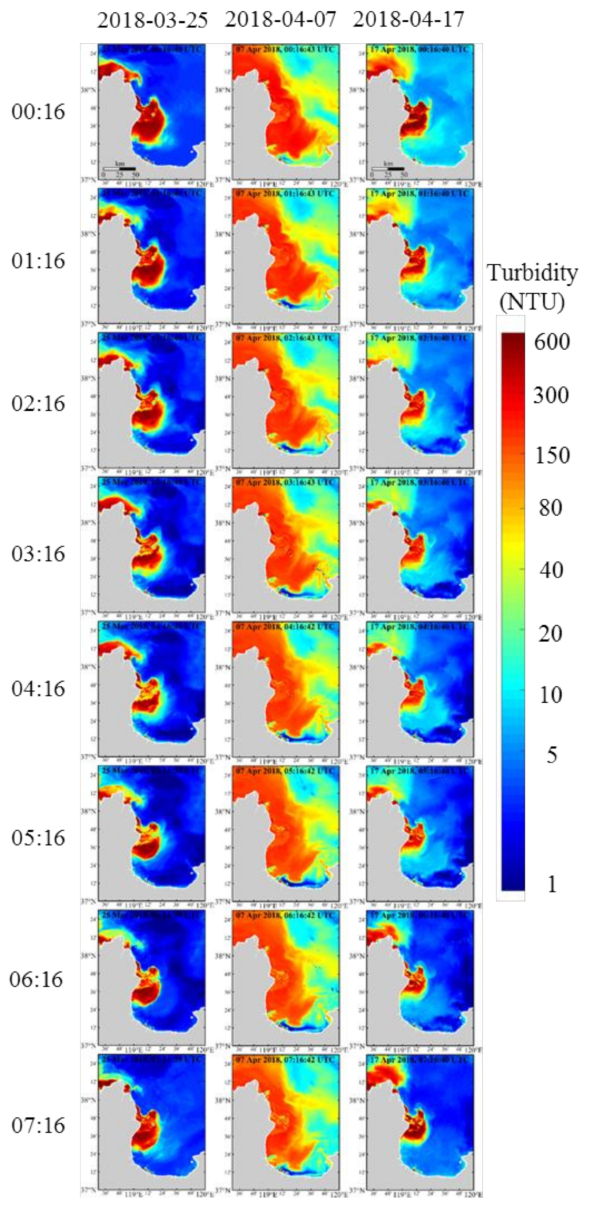
Figure 6 shows the hourly distributions of turbidity in the Yellow River Estuary on 25 March (left panel), 7 April (middle panel), and 17 April 2018 (right panel), respectively. A general pattern was observed on 25 March 2018, with high value in coastal waters and low value in offshore waters. Diurnal variations of turbidity were observed. The water turbidity was the highest at 00:16 (UTC). The turbidity decreases gradually from 01:16 to 05:16 and then increases gradually at 06:16 and 07:16. On 7 April 2018, the largest areas of high turbidity were observed due to strong winds during the period. The distribution pattern of water turbidity on 17 April 2018 was similar to that on 25 March 2018. However, the turbidity values on 17 April were slightly higher than the values on 25 March, especially in offshore waters and the southeastern Bohai Bay.

3.3.2. Yangtze River Estuary and Hangzhou Bay

Figure 7 shows the hourly variations of turbidity in the Yangtze River Estuary on 10 April (left panel), 8 April (middle panel), and 17 April 2018 (right panel), respectively. The basic pattern of turbidity distribution on 10 April 2018 was related to the bathymetric contour. Results showed a significant relationship between water depth and turbidity, i.e., the shallower the seawater, the higher the turbidity, and vice versa. This might be due to a large number of sediments in the bottom layer of the shallow areas that are more susceptible to the stirring effect of tidal mixing and transported to the surface layer. Additionally, the diurnal turbidity changes generally showed a decreasing trend. The difference of turbidity from coastal to offshore waters was obvious, i.e., turbidity in coastal waters (between 50 NTU and 200 NTU) was much higher than that observed in offshore waters (less than 5 NTU). At 00:16, the turbidity in the Yangtze River Estuary was the highest, and the high turbidity (about 200 NTU) was located in Hangzhou Bay. For the Yangtze River Estuary and Hangzhou Bay, the maximum turbidity was only 50–120 NTU at 07:16. The most obvious diurnal variation region in the Yangtze River Estuary was the narrow transition zone (about <1 longitude) from the coastal zone with high turbidity to the offshore zone with low turbidity, and it expanded with time from 00:16 to 07:16. The turbidity on 8 and 17 April 2018 was higher than that on 10 April 2018, but these hourly distributions were similar.

3.3.3. Turbid Zone and its Variations

As described above, the diurnal patterns of turbidity in the estuarine areas have subtle changes at different times. Here, daily mean and standard deviation (STD) of turbidity were calculated and used to highlight those regions with different levels of turbidity turbulence for selected days. Mean turbidity > 10 NTU and STD > 3.16 were chosen as the thresholds to isolate different characteristic regions, i.e., turbid zone if satisfying the conditions, otherwise non-turbid zone.
For the Yellow River Estuary, the turbid zone is mainly located around the mouth of the Yellow River and the northwest of Laizhou Bay on 25 March 2018, as shown in Figure 8a. Meanwhile, a similar pattern was found on 17 April 2018, except that the turbid zone expanded over the southeastern Bohai Bay (Figure 8c). Figure 8b shows that the turbid zone covered nearly the entire Yellow River Estuary on 7 April 2018, specially Laizhou Bay, which means that the diurnal change of turbidity was relatively more dramatic in the study area than the other two days.
For the Yangtze River Estuary, Figure 9a indicates that the turbid zone is generally distributed along the coastal regions, covering the mouth of the Yangtze River and entire Hangzhou Bay on 10 April 2018. However, on 8 and 17 April 2018, the turbid zone gradually extended eastward along the coastline as shown in Figure 9b,c. It was also found that the turbid zone in the north of 31.5°N had an obvious trend of reaching offshore along the isobath approximately, a good connection with the hydrodynamic condition which has been driven by the Yangtze River diluted water.

4. Discussion

4.1. Satellite Application of the NN Approach

This study demonstrated that the spatial distributions and variations of water turbidity in China seas can be estimated accurately using the NN approach with hourly intervals based on GOCI satellite data. Although many empirical algorithms have been successfully designed using satellite datasets for water turbidity estimation, these remote sensing algorithms are mainly based on site-specific empirical relationships between water turbidity and at-satellite Rrs or Rrc information. Additionally, sometimes they are difficult to be altered because of the mismatch in spectral bands from one senor to other satellite sensors. Compared with empirical methods, the advantage of the NN approach is that it does not require the quantitative relationship between water turbidity and remote sensing information at the sensitive bands, especially for highly turbid waters.
The second advantage of the approach is the use of at-satellite Rrc signal in place of the widely used Rrs signal. Qiu et al. [12] reported that a good correlation between Rrc(λ) and turbidity followed an exponential function, and then designed an empirical algorithm to estimate turbidity in Zhejiang coastal area using GOCI satellite Rrc data. Thus, the use of Rrc can circumvent the major challenges caused by an atmospheric correction in the complex marine environment, especially for highly turbid waters.
Furthermore, the NN model can estimate values that lie outside the boundaries of the training dataset that were never introduced to the system before. Therefore, the missing data derived by the thin clouds and turbid waters can be recovered by the NN model and are beneficial for time-series analyses to study temporal changes of turbidity. The NN model can also improve satellite products by minimizing atmospheric correction errors. In addition, data processing of a GOCI scene using the NN model takes only a few minutes, which has profound implications on near-time applications and time-series studies of ocean changes.
Overall, this study successfully estimated the water turbidity in the turbid estuaries on China’s coast, mainly covering turbid water bodies and highly turbid waters with acceptable uncertainties, using the proposed NN approach with the GOCI Rrc data. The findings presented here imply that the recommended methodology provides a new insight for building a machine learning method aiming to estimate water turbidity in other areas or using other multispectral satellite sensors, such as the MODIS, Sentinel-3/OLCI, Landsat-5/TM, and -7/ETM+. However, further investigations focusing on the applicability of the machine learning method to other satellite sensors or in other regions are still required. On the strength of the improvement in the quality of satellite remote sensing observation and more effective machine learning methods, we believe that it is prospective to automatically obtain a higher estimation accuracy of water turbidity in any water areas in the future.

4.2. Relationships Between Diurnal Variation and Tide

The fluvial discharge can be reasonably taken as unchanged during the day; therefore, the tide can be considered as the main factor for the diurnal variation. display turbidity diurnal variation spatially via turbid zone, which we defined by using the threshold of mean turbidity > 10 NTU and STD > 3.16. Through the turbid zone, we can determine the extension of SPM diurnal variation in one day.
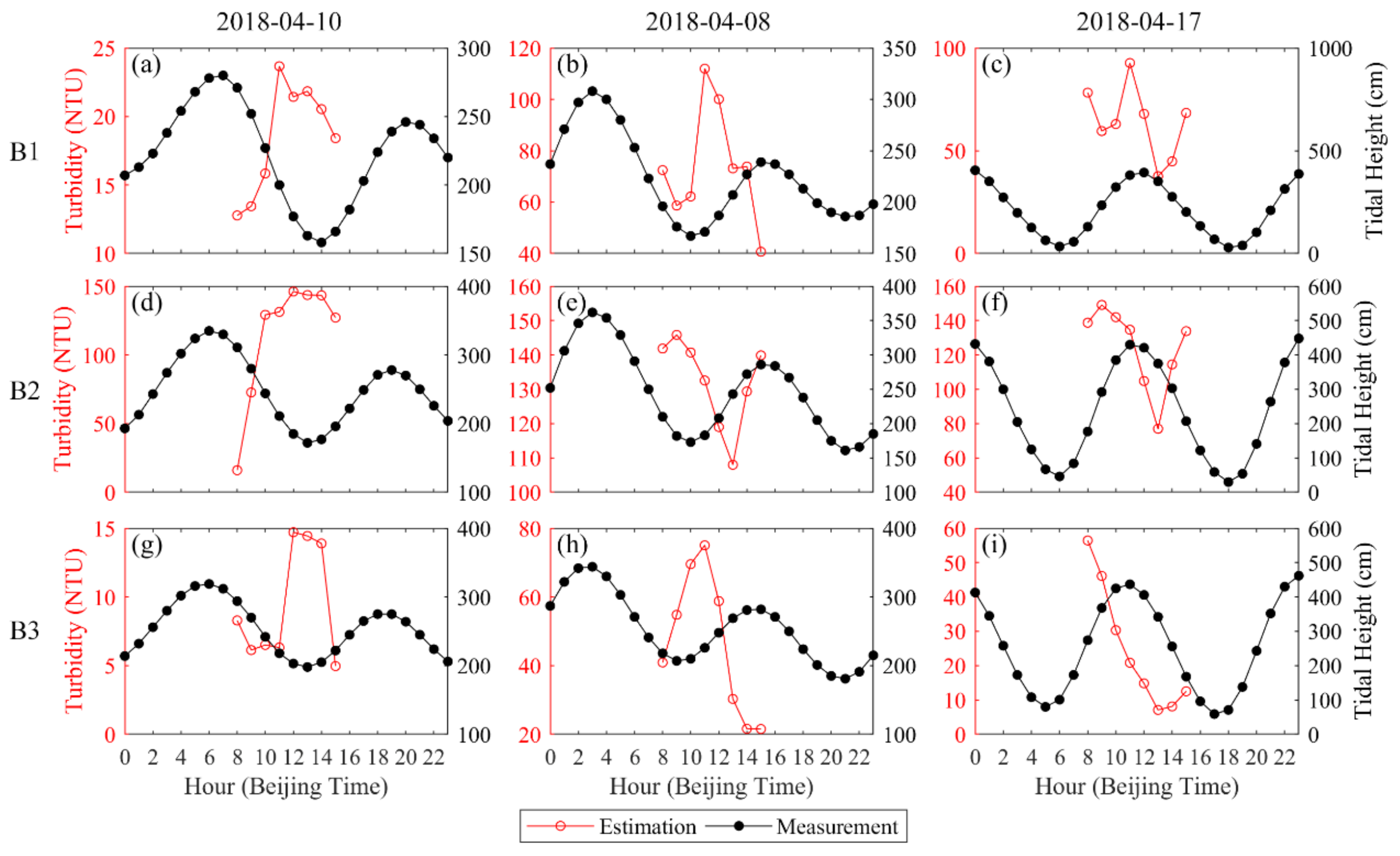
To further quantify the relationships between diurnal variation and tide, we selected six representative tidal stations in the Yellow River Estuary and Yangtze River Estuary (Figure 1b,c). The tidal heights of the three stations (A1, A2, and A3) in the Yellow River Estuary were plotted hourly on 25 March, 7 April, and 17 April 2018 (Figure 10), and the three stations (B1, B2, and B3) in the Yangtze River Estuary were plotted hourly on 8 April, 10 April, and 17 April 2018 (Figure 11). The GOCI-derived hourly turbidity was also marked in red. The different locations exhibited different tidal height variation magnitudes. As a station, A1 in Figure 10c reveals the minimum magnitude of the tidal range was about 44 cm. The maximum variation that occurred in station B3 was up to 430 cm (Figure 11i).
In Figure 10, close covariation relationships were observed between turbidity and tidal height. In most scenarios, two high tides and two low tides were observed. During the window of GOCI observation (eight hours), normally only one high tide or the low tide was observed. When the value of turbidity is high, the corresponding tidal height is usually low, and vice versa. Figure 10i shows a good example in the station A3 on 17 April 2018. The low tide down to 20 cm occurred at about 7 a.m. (Beijing Time). Due to GOCI starting working at 8 a.m. each day, turbidity derived from GOCI was available from 8 a.m. to 3 p.m. In Figure 10i, the highest turbidity was observed at 8 a.m., close to the low tide. And the lowest turbidity was observed at 1 p.m. at which the high tide up to 140 cm occurred.
The same relationships were revealed in the Yangtze River Estuary (Figure 11). For example, Figure 11h shows that the highest turbidity of 76 NTU was observed at 11 a.m. and the low tide occurred at 10 a.m. Furthermore, the lowest turbidity of 21 NTU was observed at 3 p.m., which corresponds to the high tide.
Diurnal variations of turbidity were observed opposite to the variations of the tide. That is, the periods of turbidity varying from high values to low values normally correspond to tides changing from low tide to high tide. However, the time of highest turbidity corresponding to low tide and lowest turbidity corresponding to high tide is not exactly the same. Actually, bias was always observed, for example, the highest turbidity in station B3 on 8 April 2018 was observed at 11 a.m. and the low tide was at 10 a.m. (Figure 11h).
One reason is that the water level is low at low tide, for example, only tens cm in stations in the Yellow River Estuary. The currents and waves and other hydrodynamic processes are easy to drive particles re-suspending from the bottom and stir, which increases turbidity dramatically. That is why high turbidity normally corresponds to low tide.
Furthermore, the intensity of tidal currents is not synchronous with tidal height. Actually, the tidal current speeds are lowest at low tide or high tide. Thus, the lowest turbidity always corresponds to high tide, because of the highest water level and lowest tidal currents. The highest turbidity will correspond to the maximum combination effects of low water level and strong tidal currents, which might be a few hours shifting from the low tide.
Tidal amplitude will change in days, for example, spring tide and neap tide. It means that the effects of the tide on turbidity will vary on different days. Figure 8 and Figure 9 show the variations of distributions of the turbid zones. Similar shape but different amplitudes were observed among the distributions of the turbid zones [16]. However, a special pattern is presented in Figure 8b. Large areas of the Yellow River Estuary were specified as turbid zones on 7 April 2018. It is not due to only the effects of the tide but also other factors. On 6 April 2018, a variable zonal wind on a 10 m level of 5.05 m s−1 was reached. Intensive wind–wave patterns frequently drive the resuspension of surface sediments in the Yellow River Estuary and other turbid waters of eastern China [36,37,38]. Note that wind speeds were drawn from NCEP reanalysis data provided through the NOAA/OAR/ESRL PSD, Boulder, Colorado, USA, at the website of http://www.esrl.noaa.gov/psd/.
The diurnal variations in TSM are frequently observed, for example, in the Bohai Sea [39], in the Yellow and East China Seas [40], in the Southern North Sea [41]. The tide-induced turbulent mixing and wave-current interaction in the turbid estuaries are capable of stirring much sediment to the surface layer [42,43], which could further influence turbidity patterns through sediment resuspension and deposition. The relationships between turbidity and tides implied that diurnal variations of turbidity in the Yellow River estuary and the Yangtze River estuary were closely related to the phases of tides during the period of observation. These results match with the previous studies related to sediments estimation in the Yalu River estuary [44], Hangzhou Bay [9], and northern Jiangsu sohal water [42] using field measurements and remote sensing data.

5. Conclusions

In this study, an NN approach was designed to derive the water turbidity in the turbid estuary of the Yellow River and Yangtze River based on GOCI data. The GOCI Rayleigh-corrected reflectance was used in the NN approach instead of the widely-used remote sensing reflectance to estimate turbidity. A dataset of in situ measured turbidity collected from 9 cruises and 21 buoys observations in the Bohai Sea, Yellow Sea, and East China Sea (BYES) was used to develop and validate the NN approach. Results showed a good agreement between the GOCI satellite-derived turbidity and in situ measured data with determination coefficient R2 of 0.84, root mean square error of 58.8 NTU, mean absolute error of 25.1 NTU, mean relative error of 34.4%. Comparisons with some existing empirical algorithms showed that the NN approach has better performance. The hourly spatial distributions of water turbidity derived from GOCI suggested that high turbidity regions were distributed in the Yellow River estuary, the Yangtze River estuary, and the Hangzhou Bay. These high turbidity areas gradually narrow southward. The water turbidity offshore of the East China Sea was less than 1 NTU. Significantly diurnal variations of turbidity were observed in the Yellow River Estuary and the Yangtze River Estuary from the GOCI-derived turbidity at three different dates.
Furthermore, the relationship between water turbidity and the tide was discussed in the Yellow River Estuary and Yangtze River Estuary based on GOCI satellite-derived turbidity data and numerical simulation of tidal information. A defined turbid zone is used to evaluate the diurnal variations of turbidity, which has subtle changes at different times. Our results showed an inverse relationship between turbidity and tide over six selected stations, i.e., when the value of turbidity is high, then the corresponding tidal height is usually low, and vice versa. The combined effects of tidal height and tidal currents could explain the phenomena, and other factors such as winds also contribute to the turbidity distributions.
The water turbidity was successfully estimated in the turbid estuaries on China’s coast by using the NN approach. The advantages are that the model does not require the quantitative relationship between water turbidity and remote sensing information at the sensitive bands, improves satellite products by minimizing atmospheric correction errors, and can estimate values that lie outside the boundaries of the training dataset that never introduce to the system before. Therefore, it is prospective to build an NN method aiming to estimate water turbidity covering various areas or using different multispectral satellite sensors.

Author Contributions

Conceptualization, Z.Q. and Y.Z.; methodology, J.F.; software, H.C.; validation, H.Z., Z.L., and Y.Y.; formal analysis, J.F. and M.B.; investigation, H.C. and M.B.; resources, J.F.; data curation, H.C.; writing—original draft preparation, J.F.; writing—review and editing, Y.Z.; visualization, H.Z.; supervision, Z.Q.; project administration, J.F.; funding acquisition, Z.Q. All authors have read and agreed to the published version of the manuscript.

Funding

This research was supported by the National Natural Science Foundation of China (NSFC) (No. 41976165, U1901215, 51779082, and 51009051) and the Marine Special Program of Jiangsu Province in China (JSZRHYKJ202007).

Acknowledgments

GOCI satellite data and in situ measurements in this study are highly appreciated. The authors would like to thank three anonymous reviewers for their constructive comments that improved the manuscript. Special thanks go to all persons who helped to collect in situ data. This research was supported by the National Natural Science Foundation of China (NSFC) (No. 41976165, U1901215, 51779082, and 51009051) and the Marine Special Program of Jiangsu Province in China (JSZRHYKJ202007).

Conflicts of Interest

The authors declare no conflict of interest.

References

  1. Platt, T.; Sathyendranath, S.; Caverhill, C.M.; Lewis, M.R. Ocean primary production and available light: Further algorithms for remote sensing. Deep Sea Res. Part A Oceanogr. Res. Pap. 1988, 35, 855–879. [Google Scholar] [CrossRef]
  2. Nechad, B.; Ruddick, K.G.; Neukermans, G. Calibration and validation of a generic multisensor algorithm for mapping of turbidity in coastal waters. Proc. Spie Int. Soc. Opt. Eng. 2009, 7473, 74730H. [Google Scholar]
  3. Davies-Colley, R.J.; Smith, D.G. Turbidity Suspenided Sediment, and Water Clarity: A Review. JAWRA J. Am. Water Resour. Assoc. 2010, 37, 1085–1101. [Google Scholar] [CrossRef]
  4. Wei, S.; Wang, M. Characterization of global ocean turbidity from Moderate Resolution Imaging Spectroradiometer ocean color observations. J. Geophys. Res. Ocean. 2010, 115. [Google Scholar] [CrossRef] [Green Version]
  5. Zheng, L.; Qiu, Z.; Zhou, Y.; Sun, D.; Wang, S.; Wu, W.; Perrie, W. Comparisons of algorithms to estimate water turbidity in the coastal areas of China. Int. J. Remote Sens. 2016, 37, 6165–6186. [Google Scholar] [CrossRef]
  6. Goodin, D.G.; Jr, J.A.H.; Nellis, M.D.; Rundquist, D.C. Mapping Reservoir Turbidity Patterns Using SPOT-HRV Data. Geocarto Int. 1996, 11, 71–78. [Google Scholar] [CrossRef]
  7. Chen, Z.; Muller-Karger, F.E.; Hu, C. Remote sensing of water clarity in Tampa Bay. Remote Sens. Envrion. 2007, 109, 249–259. [Google Scholar] [CrossRef]
  8. Dogliotti, A.I.; Ruddick, K.; Nechad, B.; Lasta, C.; Mercado, A.; Hozbor, C.; Guerrero, R.; López, G.R.; Abelando, M. Calibration and validation of an algorithm for remote sensing of turbidity over La Plata river estuary, Argentina. EARSeL eProc. 2011, 10, 119–130. [Google Scholar]
  9. He, X.; Yan, B.; Pan, D.; Huang, N.; Xu, D.; Chen, J.; Chen, C.T.A.; Cui, Q. Using geostationary satellite ocean color data to map the diurnal dynamics of suspended particulate matter in coastal waters. Remote Sens. Envrion. 2013, 133, 225–239. [Google Scholar] [CrossRef]
  10. Choubey, V.K. Correlation of turbidity with Indian Remote Sensing Satellite-1A data. Int. Assoc. Sci. Hydrol. Bull. 1993, 37, 129–140. [Google Scholar] [CrossRef]
  11. Dogliotti, A.I.; Ruddick, K.G.; Nechad, B.; Doxaran, D.; Knaeps, E. A single algorithm to retrieve turbidity from remotely-sensed data in all coastal and estuarine waters. Remote Sens. Envrion. 2015, 156, 157–168. [Google Scholar] [CrossRef] [Green Version]
  12. Qiu, Z.; Zheng, L.; Zhou, Y.; Sun, D.; Wang, S.; Wu, W. Innovative GOCI algorithm to derive turbidity in highly turbid waters: A case study in the Zhejiang coastal area. Opt. Express 2015, 23, A1179–A1193. [Google Scholar] [CrossRef] [PubMed]
  13. Su, J.; Wang, K. Changjiang river plume and suspended sediment transport in Hangzhou Bay. Cont. Shelf Res. 1989, 9, 93–111. [Google Scholar]
  14. Schoellhamer, D.H. Influence of salinity, bottom topography, and tides on locations of estuarine turbidity maxima in northern San Francisco Bay. Proc. Mar. Sci. 2013, 3, 343–357. [Google Scholar]
  15. Constantin, S.; Doxaran, D.; Constantinescu, Ș. Estimation of water turbidity and analysis of its spatio-temporal variability in the Danube River plume (Black Sea) using MODIS satellite data. Cont. Shelf Res. 2016, 112, 14–30. [Google Scholar] [CrossRef]
  16. Qiu, Z.; Cong, X.; Perrie, W.; Sun, D.; He, Y. Using Landsat 8 data to estimate suspended particulate matter in the Yellow River estuary. J. Geophys. Res. Ocean. 2017, 122, 276–290. [Google Scholar] [CrossRef]
  17. Hui, Y.; Zheng, M.; Liu, Z.; Gao, L. Distribution of polycyclic aromatic hydrocarbons in sediments from Yellow River Estuary and Yangtze River Estuary, China. J. Envrion. Sci. 2009, 21, 1625–1631. [Google Scholar] [CrossRef]
  18. Zhang, J. Heavy metal compositions of suspended sediments in the Changjiang (Yangtze River) estuary: Significance of riverine transport to the ocean. Cont. Shelf Res. 1999, 19, 1521–1543. [Google Scholar] [CrossRef]
  19. Ying, L.; Ling, C.; Zhao, J.; Huang, Q.; Zhu, Z.; Gao, H. Distribution and sources of polycyclic aromatic hydrocarbons in surface sediments of rivers and an estuary in Shanghai, China. Envrion. Pollut. 2008, 154, 298–305. [Google Scholar]
  20. Cong, M.; Jiang, T.; Qi, Y.Z.; Dong, H.P.; Teng, D.Q.; Lu, S.H. Phosphorus forms and distribution in Zhejiang coastal sediment in the East China Sea. Int. J. Sediment Res. 2014, 29, 278–284. [Google Scholar] [CrossRef]
  21. Ryu, J.H.; Han, H.J.; Cho, S.; Park, Y.J.; Ahn, Y.H. Overview of geostationary ocean color imager (GOCI) and GOCI data processing system (GDPS). Ocean Sci. J. 2012, 47, 223–233. [Google Scholar] [CrossRef]
  22. Ahn, J.H.; Park, Y.J.; Ryu, J.H.; Lee, B.; Oh, I.S. Development of atmospheric correction algorithm for Geostationary Ocean Color Imager (GOCI). Ocean Sci. J. 2012, 47, 247–259. [Google Scholar] [CrossRef]
  23. Wang, M.; Gordon, H.R. A simple, moderately accurate, atmospheric correction algorithm for SeaWiFS. Remote Sens. Envrion. 1994, 50, 231–239. [Google Scholar] [CrossRef]
  24. Zhang, H.; Wang, S.; Qiu, Z.; Sun, D.; Ishizaka, J.; Sun, S.; He, Y. Phytoplankton size class in the East China Sea derived from MODIS satellite data. Biogeosciences 2018, 15, 4271–4289. [Google Scholar] [CrossRef] [Green Version]
  25. Atkinson, P.M.; Tatnall, A.R.L. Introduction Neural networks in remote sensing. Int. J. Remote Sens. 1997, 18, 699–709. [Google Scholar] [CrossRef]
  26. Zhang, Y.; Pulliainen, J.; Koponen, S.; Hallikainen, M. Application of an empirical neural network to surface water quality estimation in the Gulf of Finland using combined optical data and microwave data. Remote Sens. Envrion. 2002, 81, 327–336. [Google Scholar] [CrossRef]
  27. Sun, D.Y.; Li, Y.M.; Wang, Q.; Lu, H.; Le, C.F.; Huang, C.C.; Gong, S.Q. A neural-network model to retrieve CDOM absorption from in situ measured hyperspectral data in an optically complex lake: Lake Taihu case study. Int. J. Remote Sens. 2011, 32, 4005–4022. [Google Scholar] [CrossRef]
  28. Verrelst, J.; Muñoz, J.; Alonso, L.; Delegido, J.; Rivera, J.P.; Camps-Valls, G.; Moreno, J. Machine learning regression algorithms for biophysical parameter retrieval: Opportunities for Sentinel-2 and -3. Remote Sens. Envrion. 2012, 118, 127–139. [Google Scholar] [CrossRef]
  29. Chen, J.; Quan, W.; Cui, T.; Song, Q.; Lin, C. Remote sensing of absorption and scattering coefficient using neural network model: Development, validation, and application. Remote Sens. Envrion. 2014, 149, 213–226. [Google Scholar] [CrossRef]
  30. Chen, S.; Hu, C.; Barnes, B.B.; Wanninkhof, R.; Cai, W.-J.; Barbero, L.; Pierrot, D. A machine learning approach to estimate surface ocean pCO2 from satellite measurements. Remote Sens. Envrion. 2019, 228, 203–226. [Google Scholar] [CrossRef]
  31. Mas, J.F.; Flores, J.J. The application of artificial neural networks to the analysis of remotely sensed data. Int. J. Remote Sens. 2008, 29, 617–663. [Google Scholar] [CrossRef]
  32. Hu, J.W.; Chen, S.G.; Zhang, T.L.; Zhang, G.P. Spatial and temporal variations of turbidity in the East China Seas derived from MODIS satellite data. Mar. Envrion. Sci. 2015, 34, 564–569. [Google Scholar]
  33. Lee, Z.; Lubac, B.; Werdell, J.; Arnone, R. An Update of the Quasi-Analytical Algorithm (Qaa_V5). Available online: http://www.ioccg.org/groups/software.html (accessed on 15 November 2020).
  34. Haidvogel, D.B.; Arango, H.G.; Hedstrom, K.; Beckmann, A.; Malanotte-Rizzoli, P.; Shchepetkin, A.F. Model evaluation experiments in the North Atlantic Basin: Simulations in nonlinear terrain-following coordinates. Dyn. Atmos. Oceans 2000, 32, 239–281. [Google Scholar] [CrossRef]
  35. Marchesiello, P.; Mcwilliams, J.C.; Shchepetkin, A. Equilibrium structure and dynamics of the California Current System. J. Phys. Oceanogr. 2003, 33, 753–783. [Google Scholar] [CrossRef]
  36. Zhang, Y.; Huang, Z.; Fu, D.; Tsou, J.Y.; Jiang, T.; Liang, X.S.; Lu, X. Monitoring of chlorophyll-a and sea surface silicate concentrations in the south part of Cheju island in the East China sea using MODIS data. Int. J. Appl. Earth Obs. 2018, 67, 173–178. [Google Scholar] [CrossRef]
  37. Zhang, Y.; Hallikainen, M.; Zhang, H.; Li, Y.; Liang, X.; Tsou, J. Chlorophyll-a estimation in turbid waters using combined SAR Data with hyperspectral reflectance Data: A case study in Lake Taihu, China. IEEE J. Sel. Top. Appl. Earth Obs. Remote Sens. 2018, 11, 1325–1336. [Google Scholar] [CrossRef]
  38. Ji, C.; Zhang, Y.; Cheng, Q.; Tsou, J.; Jiang, T.; Liang, X.S. Evaluating the impact of sea surface temperature (SST) on spatial distribution of chlorophyll-a concentration in the East China Sea. Int. J. Appl. Earth Obs. 2018, 68, 252–261. [Google Scholar] [CrossRef]
  39. Yang, H.; Choi, J.-K.; Park, Y.-J.; Han, H.-J.; Ryu, J.-H. Application of the Geostationary Ocean Color Imager (GOCI) to estimates of ocean surface currents. J. Geophys. Res. 2014, 119, 3988–4000. [Google Scholar] [CrossRef]
  40. Son, S.; Kim, Y.H.; Kwon, J.I.; Kim, H.C.; Park, K.S. Characterization of spatial and temporal variation of suspended sediments in the Yellow and East China Seas using satellite ocean color data. Remote Sens. 2014, 51, 212–226. [Google Scholar] [CrossRef]
  41. Neukermans, G.; Ruddick, K.; Bernard, E.; Ramon, D.; Nechad, B.; Deschamps, P.-Y. Mapping total suspended matter from geostationary satellites: A feasibility study with SEVIRI in the Southern North Sea. Opt. Express 2009, 17, 14029–14052. [Google Scholar] [CrossRef] [Green Version]
  42. Cheng, Z.; Wang, X.H.; Paull, D.; Gao, J. Application of the geostationary ocean color imager to mapping the diurnal and seasonal variability of surface suspended matter in a macro-tidal estuary. Remote Sens. 2016, 8, 244. [Google Scholar] [CrossRef] [Green Version]
  43. Hu, Z.; Pan, D.; He, X.; Bai, Y. Diurnal variability of turbidity fronts observed by geostationary satellite ocean color remote sensing. Remote Sens 2016, 8, 147. [Google Scholar] [CrossRef] [Green Version]
  44. Yu, Q.; Wang, Y.; Gao, J.; Gao, S.; Flemming, B. Turbidity maximum formation in a well-mixed macrotidal estuary: The role of tidal pumping. J. Geophys. Res. Ocean. 2014, 119, 7705–7724. [Google Scholar] [CrossRef] [Green Version]
Figure 1. Location of sampling stations of cruise observations (grey dots) and buoys (red triangle) (a); location of the Yellow River Estuary in the Bohai Sea (b) and the Yangtze River Estuary and Hangzhou Bay in the East China Sea (c).
Remotesensing 12 03770 g001
Figure 2. Illustration of a standard feed-forward neural network.
Remotesensing 12 03770 g002
Figure 3. Histogram of the in situ turbidity measurements from (a) cruise samples; (b) the buoys moored in the Sheyang observation station in the north of Jiangsu Coastal area (JS); (c) the buoys placed in the Qingcaosha Reservoir nearby the Yangtze River Estuary (SK); (d) the buoys located in the coastal areas of Zhejiang Province (ZJ) in the satellite-field matchup dataset.
Remotesensing 12 03770 g003
Figure 4. Statistics of water turbidity of calibration dataset and validation dataset.
Remotesensing 12 03770 g004
Figure 5. Comparisons between the in situ measured and modeled turbidities for model development (a) and validation (b).
Remotesensing 12 03770 g005
Figure 6. Diurnal turbidity patterns of the Yellow River Estuary on 25 March (left panel), 7 April (middle panel), and 17 April (right panel) of 2018.
Remotesensing 12 03770 g006
Figure 7. Diurnal turbidity patterns of the Yangtze River Estuary on 10 April (left panel), 8 April (middle panel), and 17 April (right panel) of 2018.
Remotesensing 12 03770 g007
Figure 8. Spatial distributions of turbid zones of the Yellow River Estuary on 25 March (a), 7 April (b), 17 April (c) of 2018.
Remotesensing 12 03770 g008
Figure 9. Spatial distributions of turbid zones of the Yangtze River Estuary on 10 April (a), 8 April (b), and 17 April (c) of 2018.
Remotesensing 12 03770 g009
Figure 10. Comparison between estimated turbidity and measured the tidal height at three different locations (A1A3) in the Yellow River Estuary on 25 March (left panel), (a,d,g), 7 April (middle panel), (b,e,h), and 17 April (right panel), (c,f,i) of 2018.
Remotesensing 12 03770 g010
Figure 11. Comparison between estimated turbidity and measured the tidal height at three different locations (B1–B3) in the Yangtze River Estuary on 10 April (left panel), (a,d,g), 8 April (middle panel), (b,e,h), and 17 April (right panel), (c,f,i) of 2018.
Remotesensing 12 03770 g011
Table 1. The selected geostationary ocean color imager (GOCI) images and tidal information on the same day in this study.
RegionThe Selected GOCI ImagesTidal Information
Yellow River Estuary25 March 2018 (0:15 to 07:35 UTC)Neap tide
7 April 2018 (0:15 to 07:35 UTC)Middle tide
17 April 2018 (0:15 to 07:35 UTC)Spring tide
Yangtze River Estuary10 April 2018 (0:15 to 07:35 UTC)Neap tide
8 April 2018 (0:15 to 07:35 UTC)Middle tide
17 April 2018 (0:15 to 07:35 UTC)Spring tide
Table 2. Description of three published models for comparison used in this study.
ModelsReferenceFormulaInput Variables *
Model AQiu et al. [12] T = 10 4.494 X 2 + 7.818 X 0.016 X = R rc ,   490 + R rc ,   680 R rc ,   490 / R rc ,   680 ;Rrc
Model BHe et al. [9] T = 0.6897 × TSM + 0 . 4966 TSM = 10 1.1230 * R rs ,   745 / R rs ,   490 + 1.0758 ;Rrs
Model CHu et al. [32] T = 111.35 × b bp ,   555 1.033 bbp,555
* Rrc,λ, Rrs,λ, and bbp,λ are the Rayleigh-corrected reflectance, remote sensing reflectance, and particulate backscattering coefficient at a given wavelength λ, respectively. TSM is the total suspended matter.
Table 3. Summary of the basic statistical attributes of all in situ measured turbidity data. SD, CV, and N represent standard deviation, coefficient of variation, and sample number, respectively.
Sample SourcesTurbidity Range (NTU)Mean (NTU)SD (NTU)CV (%)N
Cruises0.02–100.794.6610.16218231
JS0.30–976.0064.45107.11166220
SK5.09–791.4157.4175.58132283
ZJ2.40–330.4771.4670.5599636
Table 4. Performance comparison of the proposed NN approach and three published empirical algorithms (Model A, Model B, and Model C).
ModelsR2MAE (NTU)MRE (%)RMSE (NTU)
NN (this study)0.84525.134.458.8
Model A0.64934.680.0 70.6
Model B----
Model C0.74832.394.667.9
Publisher’s Note: MDPI stays neutral with regard to jurisdictional claims in published maps and institutional affiliations.