Quantification of Annual Settlement Growth in Rural Mining Areas Using Machine Learning
Abstract
1. Introduction
2. Materials and Methods
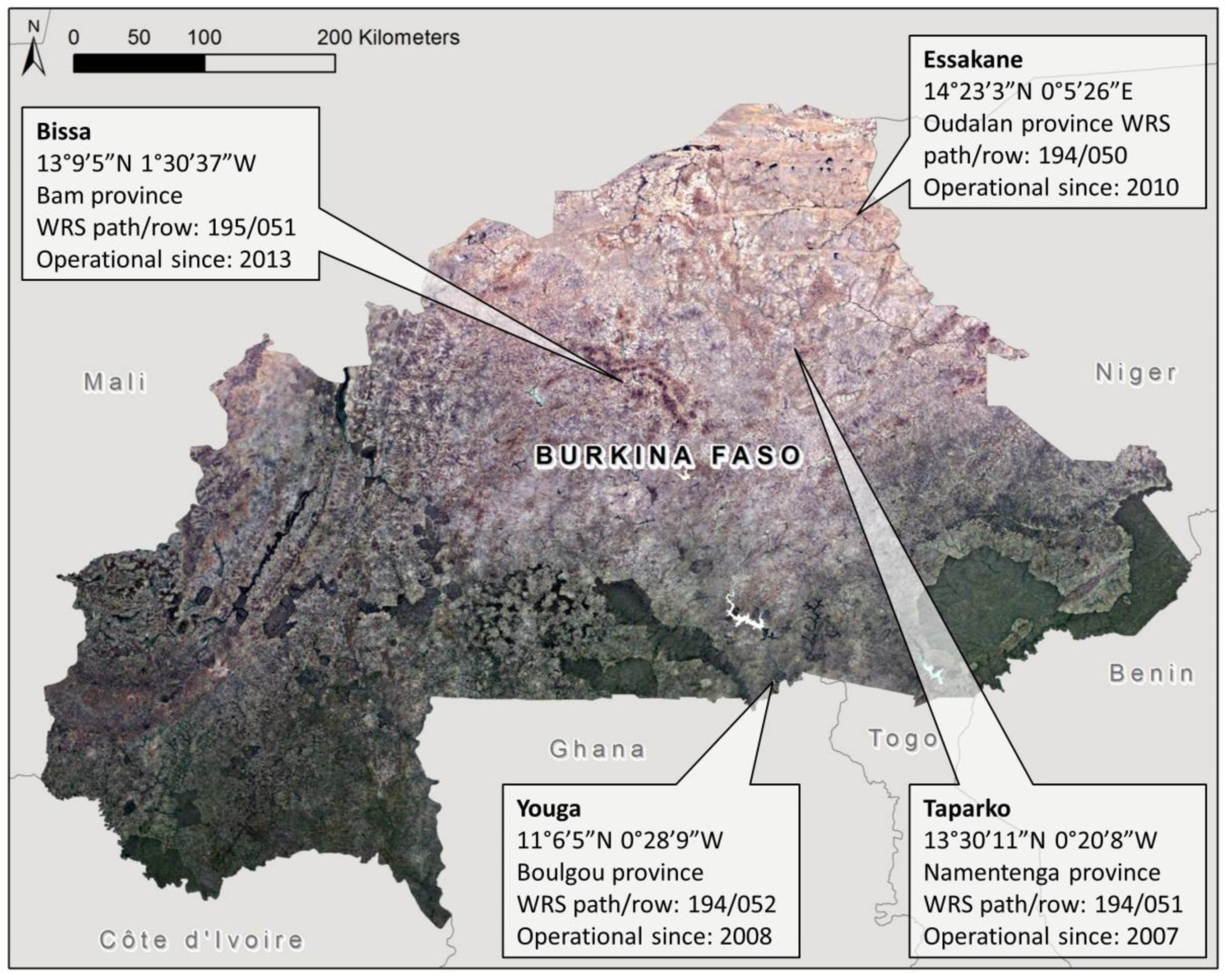
2.1. Study Area Selection
2.2. Data Sources
2.3. Land Use Classification
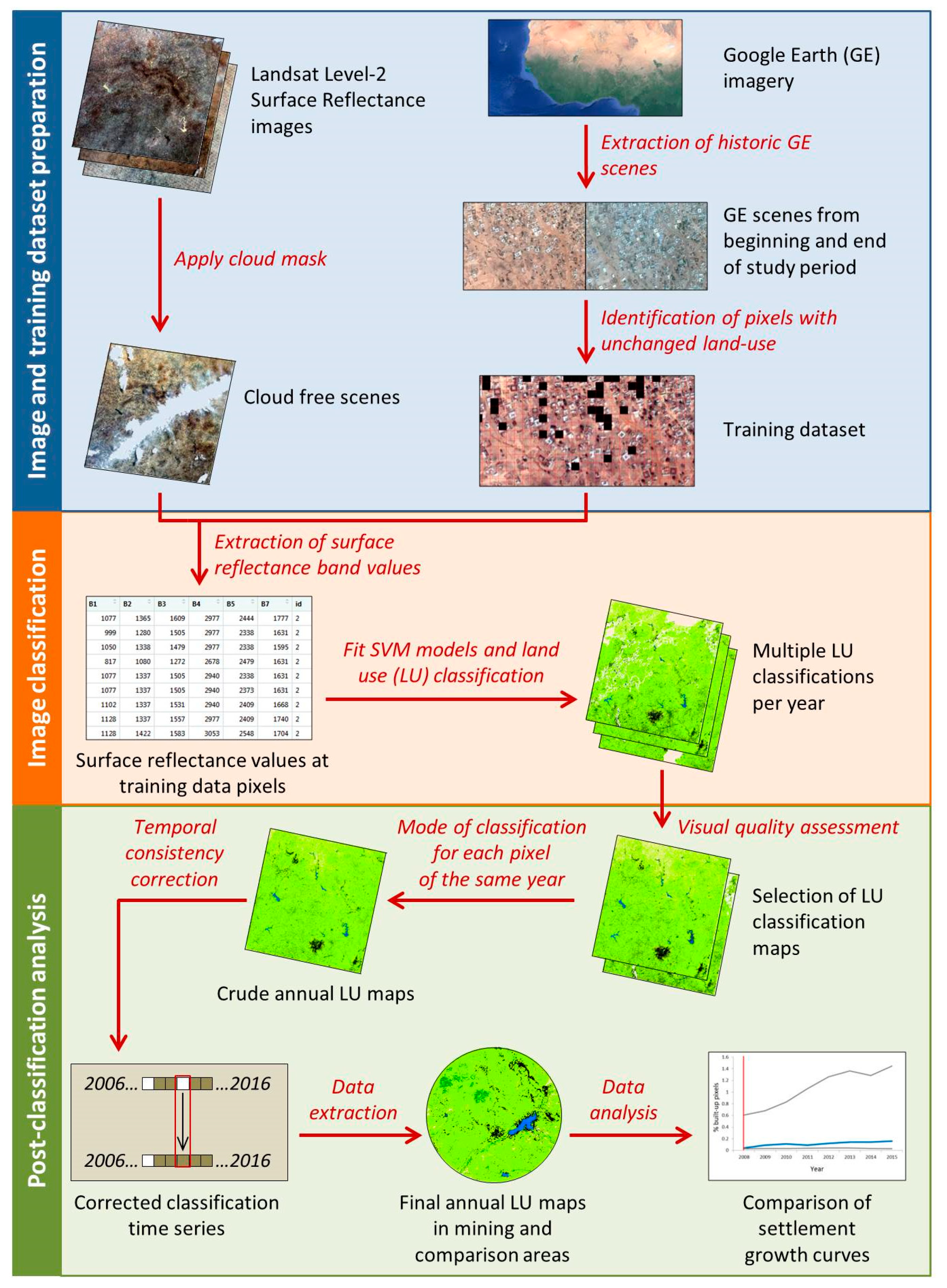
2.3.1. Image and Training Dataset Preparation
2.3.2. Image Classification
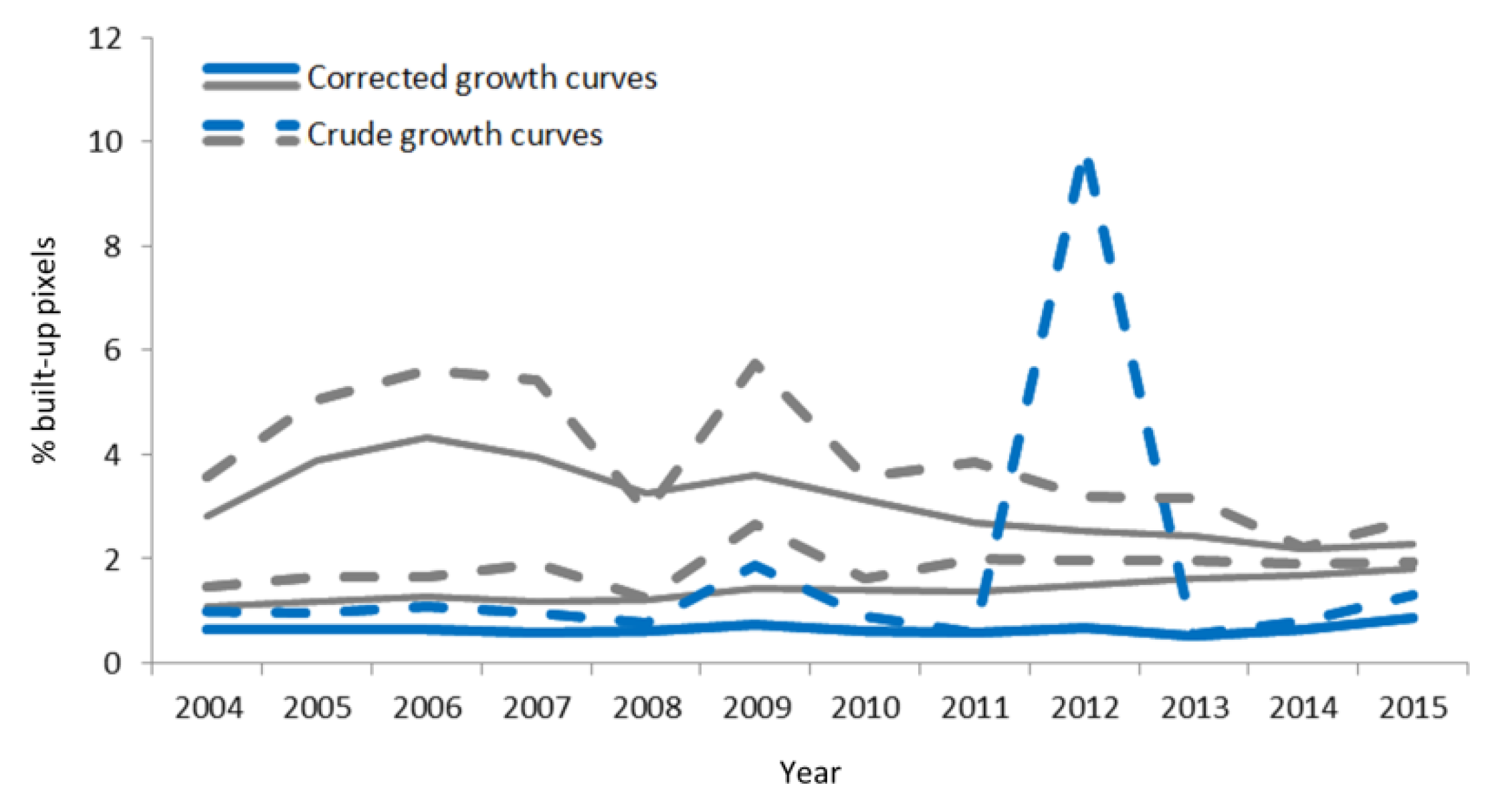
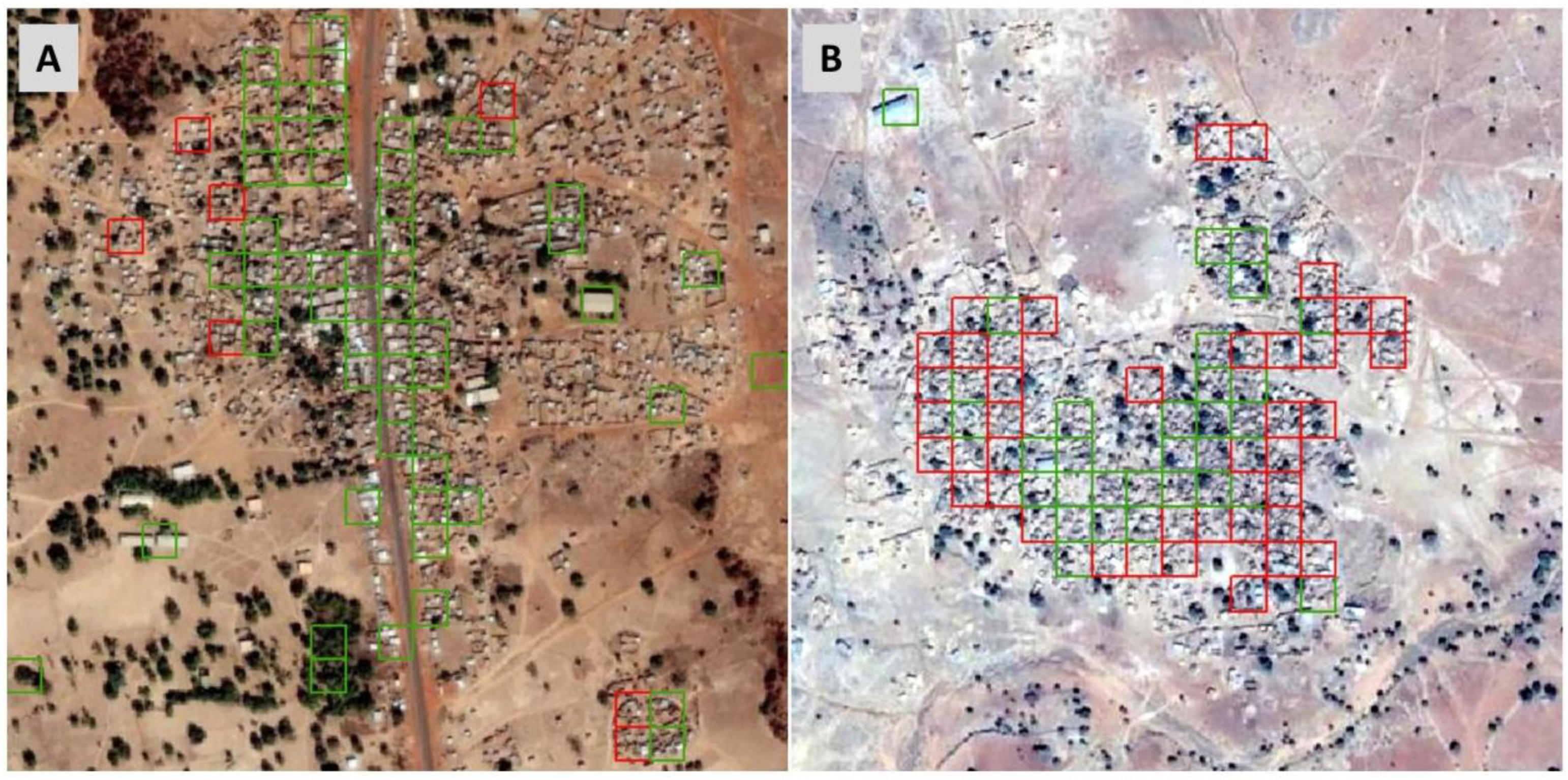
2.3.3. Post-Classification Processing
2.4. Accuracy Assessment
2.5. Data Analysis
3. Results
3.1. Availability of Landsat Satellite Imagery
3.2. Availability of Historic Google Earth Imagery
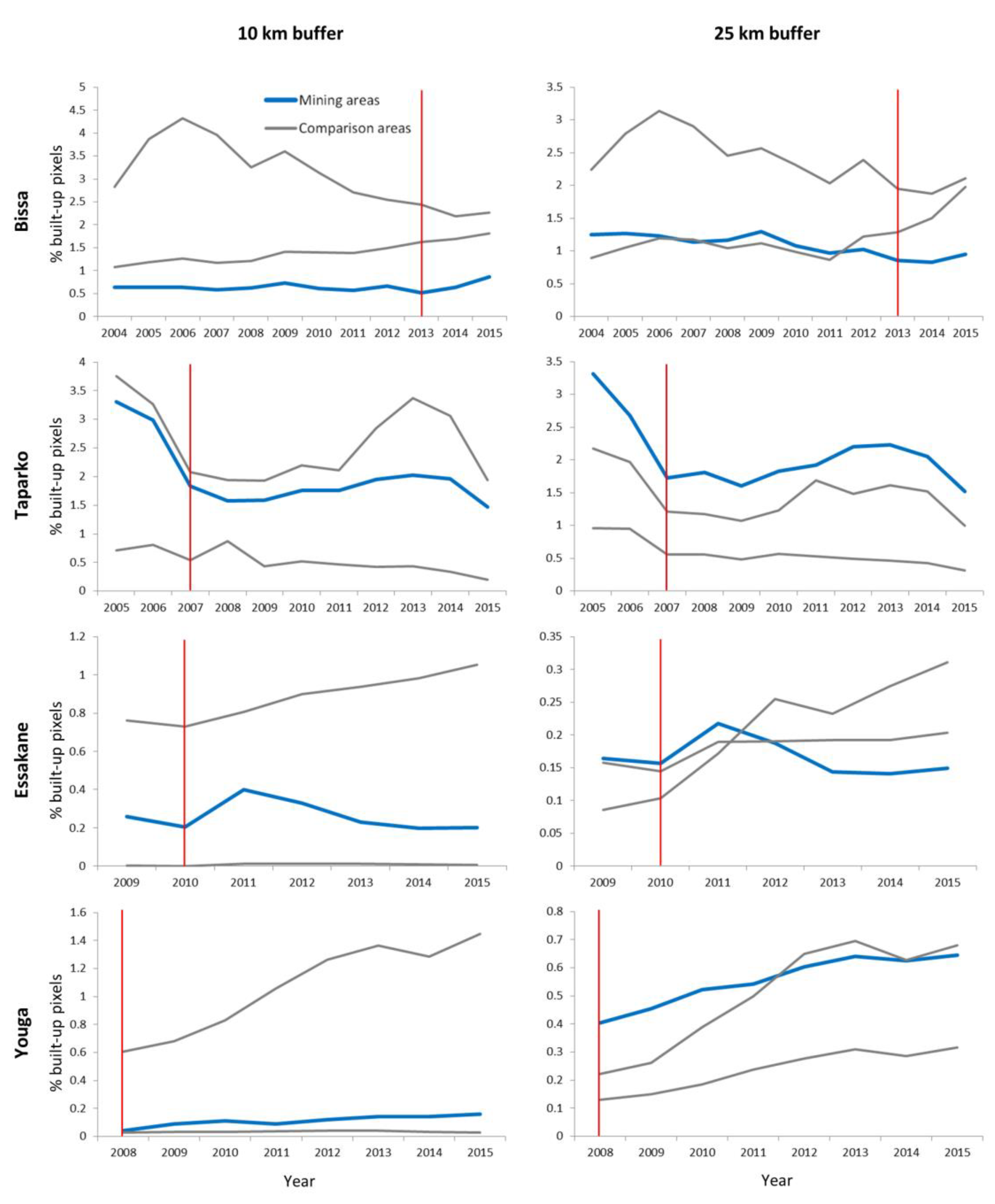
3.3. Settlement Growth in Mining and Non-Mining Areas
3.4. Accuracy Assessment
4. Discussion
5. Conclusions
Author Contributions
Funding
Acknowledgments
Conflicts of Interest
References
- Jackson, R.T. Migration to two mines in Laos. Sustain. Dev. 2018, 26, 471–480. [Google Scholar] [CrossRef]
- Nyame, F.K.; Andrew Grant, J.; Yakovleva, N. Perspectives on migration patterns in Ghana’s mining industry. Resour. Policy 2009, 34, 6–11. [Google Scholar] [CrossRef]
- IFC. Projects and People: A Handbook for Addressing Project-Induced In-Migration; International Finance Corporation: Washington, DC, USA, 2009. [Google Scholar]
- Loayza, F.; Franco, I.; Quezada, F.; Alvarado, M.; Castillo, J.; Sanchez, J.M.; Kunze, V.; Araya, R.; Pasco-Font, A.; Diez Hurtado, A.; et al. Large Mines and the Community: Socioeconomic and Environmental Effects in Latin America, Canada, and Spain; McMahon, G., Remy, F., Eds.; World Bank: Washington, DC, USA, 2001; ISBN 978-0-88936-949-8. [Google Scholar]
- Winkler, M.S.; Krieger, G.R.; Divall, M.J.; Singer, B.H.; Utzinger, J. Health impact assessment of industrial development projects: A spatio-temporal visualization. Geospat. Health 2012, 6, 299–301. [Google Scholar] [CrossRef]
- Petkova, V.; Lockie, S.; Rolfe, J.; Ivanova, G. Mining Developments and Social Impacts on Communities: Bowen Basin Case Studies. Rural Soc. 2009, 19, 211–228. [Google Scholar] [CrossRef]
- Stevens, F.R.; Gaughan, A.E.; Nieves, J.J.; King, A.; Sorichetta, A.; Linard, C.; Tatem, A.J. Comparisons of two global built area land cover datasets in methods to disaggregate human population in eleven countries from the global South. Int. J. Digit. Earth 2020, 13, 78–100. [Google Scholar] [CrossRef]
- Wardrop, N.A.; Jochem, W.C.; Bird, T.J.; Chamberlain, H.R.; Clarke, D.; Kerr, D.; Bengtsson, L.; Juran, S.; Seaman, V.; Tatem, A.J. Spatially disaggregated population estimates in the absence of national population and housing census data. Proc. Natl. Acad. Sci. USA 2018, 115, 3529–3537. [Google Scholar] [CrossRef]
- Tatem, A.J. Mapping the denominator: Spatial demography in the measurement of progress. Int. Health 2014, 6, 153–155. [Google Scholar] [CrossRef]
- United Nations. Principles and Recommendations for Population and Housing Censuses: 2020 Round; United Nations, Ed.; Economic & Social Affairs; Revision 3; United Nations: New York, NY, USA, 2017; ISBN 978-92-1-161597-5. [Google Scholar]
- Acheampong, R.A.; Agyemang, F.S.K.; Abdul-Fatawu, M. Quantifying the spatio-temporal patterns of settlement growth in a metropolitan region of Ghana. GeoJournal 2017, 82, 823–840. [Google Scholar] [CrossRef]
- Zhao, Y.; Feng, D.; Yu, L.; Cheng, Y.; Zhang, M.; Liu, X.; Xu, Y.; Fang, L.; Zhu, Z.; Gong, P. Long-Term Land Cover Dynamics (1986–2016) of Northeast China Derived from a Multi-Temporal Landsat Archive. Remote Sens. 2019, 11, 599. [Google Scholar] [CrossRef]
- Wulder, M.A.; Masek, J.G.; Cohen, W.B.; Loveland, T.R.; Woodcock, C.E. Opening the archive: How free data has enabled the science and monitoring promise of Landsat. Remote Sens. Environ. 2012, 122, 2–10. [Google Scholar] [CrossRef]
- Woodcock, C.E.; Allen, R.; Anderson, M.; Belward, A.; Bindschadler, R.; Cohen, W.; Gao, F.; Goward, S.N.; Helder, D.; Helmer, E.; et al. Free Access to Landsat Imagery. Science 2008, 320, 1011. [Google Scholar] [CrossRef] [PubMed]
- Phiri, D.; Morgenroth, J. Developments in Landsat Land Cover Classification Methods: A Review. Remote Sens. 2017, 9, 967. [Google Scholar] [CrossRef]
- Gong, P.; Li, X.; Zhang, W. 40-Year (1978–2017) human settlement changes in China reflected by impervious surfaces from satellite remote sensing. Sci. Bull. 2019, 64, 756–763. [Google Scholar] [CrossRef]
- Sexton, J.O.; Song, X.-P.; Huang, C.; Channan, S.; Baker, M.E.; Townshend, J.R. Urban growth of the Washington, D.C.–Baltimore, MD metropolitan region from 1984 to 2010 by annual, Landsat-based estimates of impervious cover. Remote Sens. Environ. 2013, 129, 42–53. [Google Scholar] [CrossRef]
- Schneider, A. Monitoring land cover change in urban and peri-urban areas using dense time stacks of Landsat satellite data and a data mining approach. Remote Sens. Environ. 2012, 124, 689–704. [Google Scholar] [CrossRef]
- Hu, T.; Yang, J.; Li, X.; Gong, P. Mapping Urban Land Use by Using Landsat Images and Open Social Data. Remote Sens. 2016, 8, 151. [Google Scholar] [CrossRef]
- Chai, B.; Li, P. Annual Urban Expansion Extraction and Spatio-Temporal Analysis Using Landsat Time Series Data: A Case Study of Tianjin, China. IEEE J. Sel. Top. Appl. Earth Obs. Remote Sens. 2018, 11, 2644–2656. [Google Scholar] [CrossRef]
- Gong, P.; Wang, J.; Yu, L.; Zhao, Y.; Zhao, Y.; Liang, L.; Niu, Z.; Huang, X.; Fu, H.; Liu, S.; et al. Finer resolution observation and monitoring of global land cover: First mapping results with Landsat TM and ETM+ data. Int. J. Remote Sens. 2013, 34, 2607–2654. [Google Scholar] [CrossRef]
- Taubenböck, H.; Esch, T.; Felbier, A.; Wiesner, M.; Roth, A.; Dech, S. Monitoring urbanization in mega cities from space. Remote Sens. Environ. 2012, 117, 162–176. [Google Scholar] [CrossRef]
- Ayele, G.T.; Tebeje, A.K.; Demissie, S.S.; Belete, M.A.; Jemberrie, M.A.; Teshome, W.M.; Mengistu, D.T.; Teshale, E.Z. Time Series Land Cover Mapping and Change Detection Analysis Using Geographic Information System and Remote Sensing, Northern Ethiopia. Air Soil Water Res. 2018, 11, 1–18. [Google Scholar] [CrossRef]
- Wohlfart, C.; Mack, B.; Liu, G.; Kuenzer, C. Multi-faceted land cover and land use change analyses in the Yellow River Basin based on dense Landsat time series: Exemplary analysis in mining, agriculture, forest, and urban areas. Appl. Geogr. 2017, 85, 73–88. [Google Scholar] [CrossRef]
- Reynolds, R.; Liang, L.; Li, X.; Dennis, J. Monitoring Annual Urban Changes in a Rapidly Growing Portion of Northwest Arkansas with a 20-Year Landsat Record. Remote Sens. 2017, 9, 71. [Google Scholar] [CrossRef]
- Schneider, A.; Mertes, C.M. Expansion and growth in Chinese cities, 1978–2010. Environ. Res. Lett. 2014, 9, 024008. [Google Scholar] [CrossRef]
- Schug, F.; Okujeni, A.; Hauer, J.; Hostert, P.; Nielsen, J.Ø.; van der Linden, S. Mapping patterns of urban development in Ouagadougou, Burkina Faso, using machine learning regression modeling with bi-seasonal Landsat time series. Remote Sens. Environ. 2018, 210, 217–228. [Google Scholar] [CrossRef]
- Qin, Y.; Xiao, X.; Dong, J.; Chen, B.; Liu, F.; Zhang, G.; Zhang, Y.; Wang, J.; Wu, X. Quantifying annual changes in built-up area in complex urban-rural landscapes from analyses of PALSAR and Landsat images. ISPRS J. Photogramm. Remote Sens. 2017, 124, 89–105. [Google Scholar] [CrossRef]
- Li, X.; Zhou, Y.; Zhu, Z.; Liang, L.; Yu, B.; Cao, W. Mapping annual urban dynamics (1985–2015) using time series of Landsat data. Remote Sens. Environ. 2018, 216, 674–683. [Google Scholar] [CrossRef]
- Farnham, A.; Cossa, H.; Dietler, D.; Engebretsen, R.; Leuenberger, A.; Lyatuu, I.; Nimako, B.; Zabre, H.R.; Brugger, F.; Winkler, M.S. A mixed methods approach for investigating health impacts of natural resource extraction projects in Burkina Faso, Ghana, Mozambique, and Tanzania: A study protocol. JMIR Res. Protoc. 2019. under review. [Google Scholar]
- Winkler, M.S.; Adongo, P.B.; Binka, F.; Brugger, F.; Diagbouga, S.; Macete, E.; Munguambe, K.; Okumu, F. Health impact assessment for promoting sustainable development: The HIA4SD project. Impact Assess. Proj. Apprais. 2020, in press. [Google Scholar] [CrossRef]
- INSD. Recensement Génélral de la Population et de L’habitation au Burkina Faso en 2006; Institut National de la Statistique et de la Démographie: Ouaga, Burkina Faso, 2006.
- Li, X.; Gong, P.; Liang, L. A 30-year (1984–2013) record of annual urban dynamics of Beijing City derived from Landsat data. Remote Sens. Environ. 2015, 166, 78–90. [Google Scholar] [CrossRef]
- Li, X.; Gong, P. An “exclusion-inclusion” framework for extracting human settlements in rapidly developing regions of China from Landsat images. Remote Sens. Environ. 2016, 186, 286–296. [Google Scholar] [CrossRef]
- Wicki, A.; Parlow, E. Attribution of local climate zones using a multitemporal land use/land cover classification scheme. J. Appl. Remote Sens. 2017, 11, 026001. [Google Scholar] [CrossRef]
- Punam, C.-P.; Dabalen, A.L.; Kotsadam, A.; Aly, S.; Tolonen, A.K. The Local Socioeconomic Effects of Gold Mining: Evidence from Ghana; World Bank Group: Washington, DC, USA, 2015. [Google Scholar]
- Vanniel, T.; Mcvicar, T.; Datt, B. On the relationship between training sample size and data dimensionality: Monte Carlo analysis of broadband multi-temporal classification. Remote Sens. Environ. 2005, 98, 468–480. [Google Scholar] [CrossRef]
- Shi, L.; Ling, F.; Ge, Y.; Foody, G.; Li, X.; Wang, L.; Zhang, Y.; Du, Y. Impervious Surface Change Mapping with an Uncertainty-Based Spatial-Temporal Consistency Model: A Case Study in Wuhan City Using Landsat Time-Series Datasets from 1987 to 2016. Remote Sens. 2017, 9, 1148. [Google Scholar] [CrossRef]
- Wulder, M.A.; Hilker, T.; White, J.C.; Coops, N.C.; Masek, J.G.; Pflugmacher, D.; Crevier, Y. Virtual constellations for global terrestrial monitoring. Remote Sens. Environ. 2015, 170, 62–76. [Google Scholar] [CrossRef]
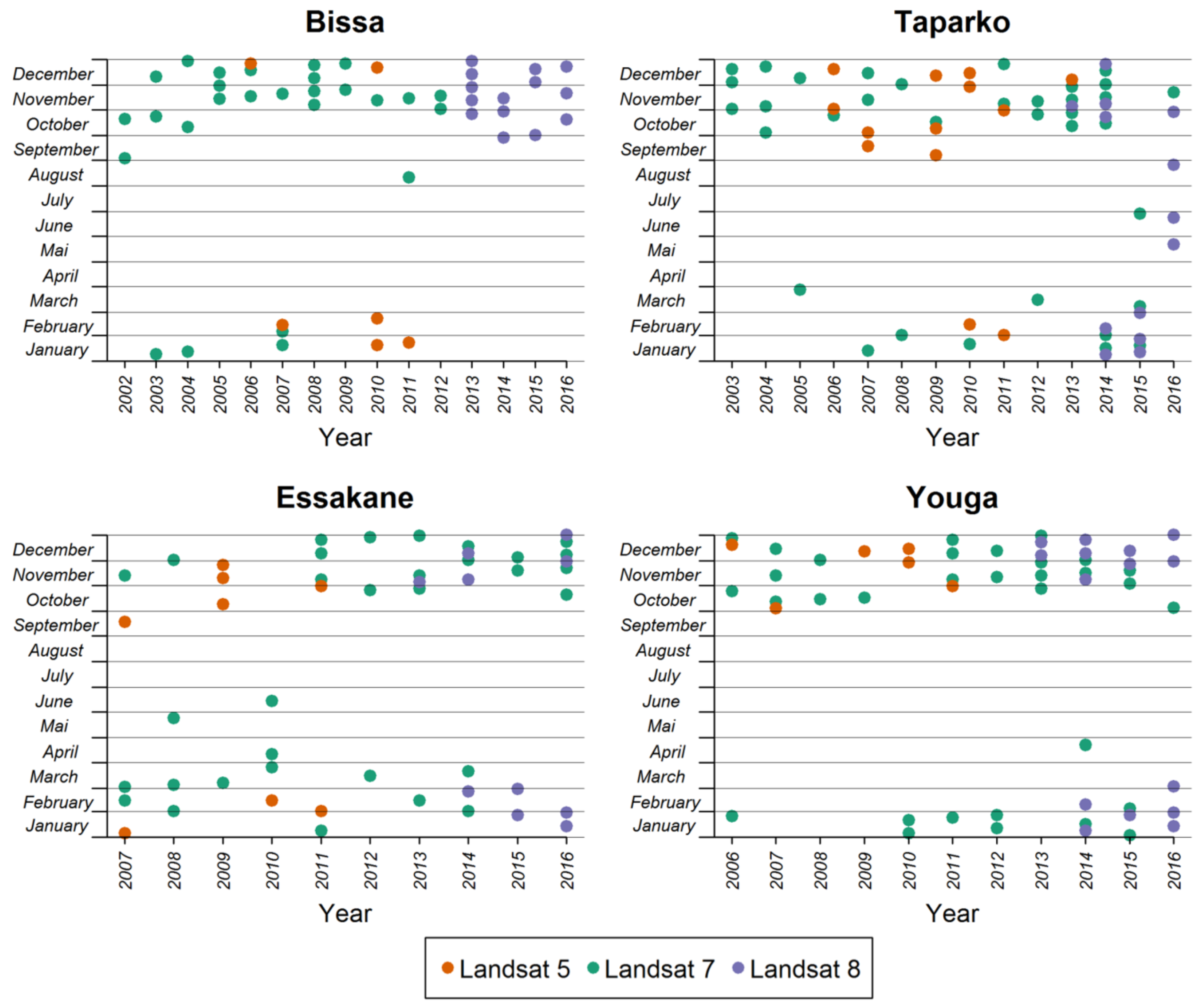
| Landsat Mission | Bissa | Taparko | Essakane | Youga | Total |
|---|---|---|---|---|---|
| Landsat 5 | 25 (6) | 28 (13) | 27 (8) | 21 (6) | 101 (33) |
| Landsat 7 | 133 (27) | 117 (35) | 95 (32) | 83 (32) | 428 (126) |
| Landsat 8 | 46 (14) | 48 (13) | 53 (10) | 40 (15) | 187 (52) |
| Total | 204 (47) | 193 (61) | 175 (50) | 144 (53) | 716 (211) |
| Approach 1 | Classification | Approach 2 | Classification | ||||
| Reference | Built-up | Other | PA | Reference | Built-up | Other | PA |
| Built-up | 130 | 197 | 39.8% | Built-up | 438 | 99 | 81.6% |
| Other | 27 | 462 | 94.5% | Other | 3 | 703 | 99.6% |
| UA | 82.8% | 70.1% | UA | 95.0% | 87.7% | ||
| OA = 72.5% | OA = 91.8% | ||||||
| Kappa = 0.375 | Kappa = 0.829 | ||||||
| Bissa | Classification | Taparko | Classification | ||||
| Reference | Built-up | Other | PA | Reference | Built-up | Other | PA |
| Built-up | 70 | 52 | 57.4% | Built-up | 60 | 145 | 29.3% |
| Other | 4 | 285 | 98.6% | Other | 23 | 177 | 88.5% |
| UA | 94.6% | 84.6% | UA | 72.3% | 55.0% | ||
| OA = 86.4% | OA = 58.5% | ||||||
| Kappa = 0.632 | Kappa = 0.176 | ||||||
| Essakane | Classification | PA | Youga | Classification | PA | ||
| Reference | Built-up | Other | Reference | Built-up | Other | ||
| Built-up | 24 | 55 | 30.4% | Built-up | 414 | 44 | 90.4% |
| Other | 0 | 200 | 100% | Other | 3 | 503 | 99.4% |
| UA | 100% | 78.4% | UA | 99.3% | 92.0% | ||
| OA = 80.3% | OA = 95.1% | ||||||
| Kappa = 0.385 | Kappa = 0.902 | ||||||
© 2020 by the authors. Licensee MDPI, Basel, Switzerland. This article is an open access article distributed under the terms and conditions of the Creative Commons Attribution (CC BY) license (http://creativecommons.org/licenses/by/4.0/).
Share and Cite
Dietler, D.; Farnham, A.; de Hoogh, K.; Winkler, M.S. Quantification of Annual Settlement Growth in Rural Mining Areas Using Machine Learning. Remote Sens. 2020, 12, 235. https://doi.org/10.3390/rs12020235
Dietler D, Farnham A, de Hoogh K, Winkler MS. Quantification of Annual Settlement Growth in Rural Mining Areas Using Machine Learning. Remote Sensing. 2020; 12(2):235. https://doi.org/10.3390/rs12020235
Chicago/Turabian StyleDietler, Dominik, Andrea Farnham, Kees de Hoogh, and Mirko S. Winkler. 2020. "Quantification of Annual Settlement Growth in Rural Mining Areas Using Machine Learning" Remote Sensing 12, no. 2: 235. https://doi.org/10.3390/rs12020235
APA StyleDietler, D., Farnham, A., de Hoogh, K., & Winkler, M. S. (2020). Quantification of Annual Settlement Growth in Rural Mining Areas Using Machine Learning. Remote Sensing, 12(2), 235. https://doi.org/10.3390/rs12020235


