Application of GNSS Interferometric Reflectometry for the Estimation of Lake Ice Thickness

 ,
,  ,
,  ,
,
Abstract

1. Introduction
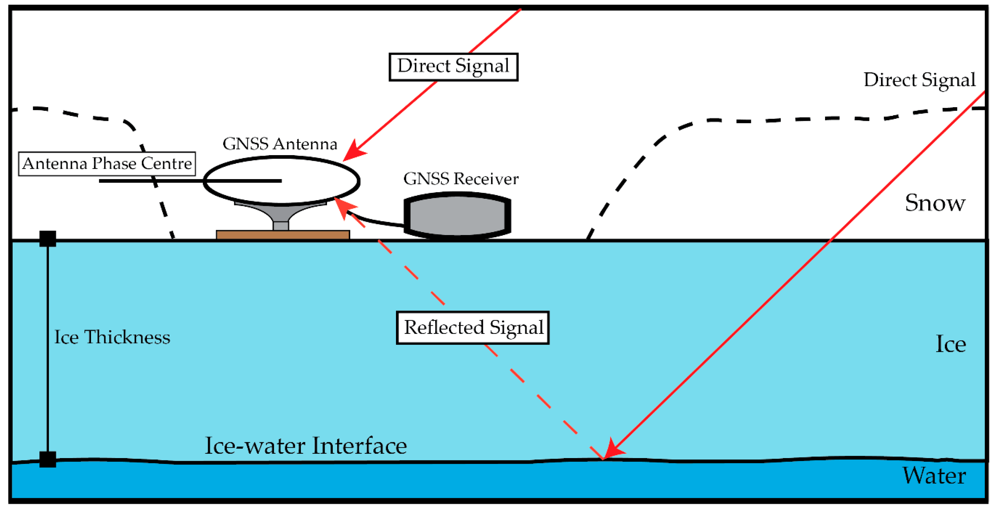
2. Methodology
2.1. Ice Thickness Retrieval from SNR
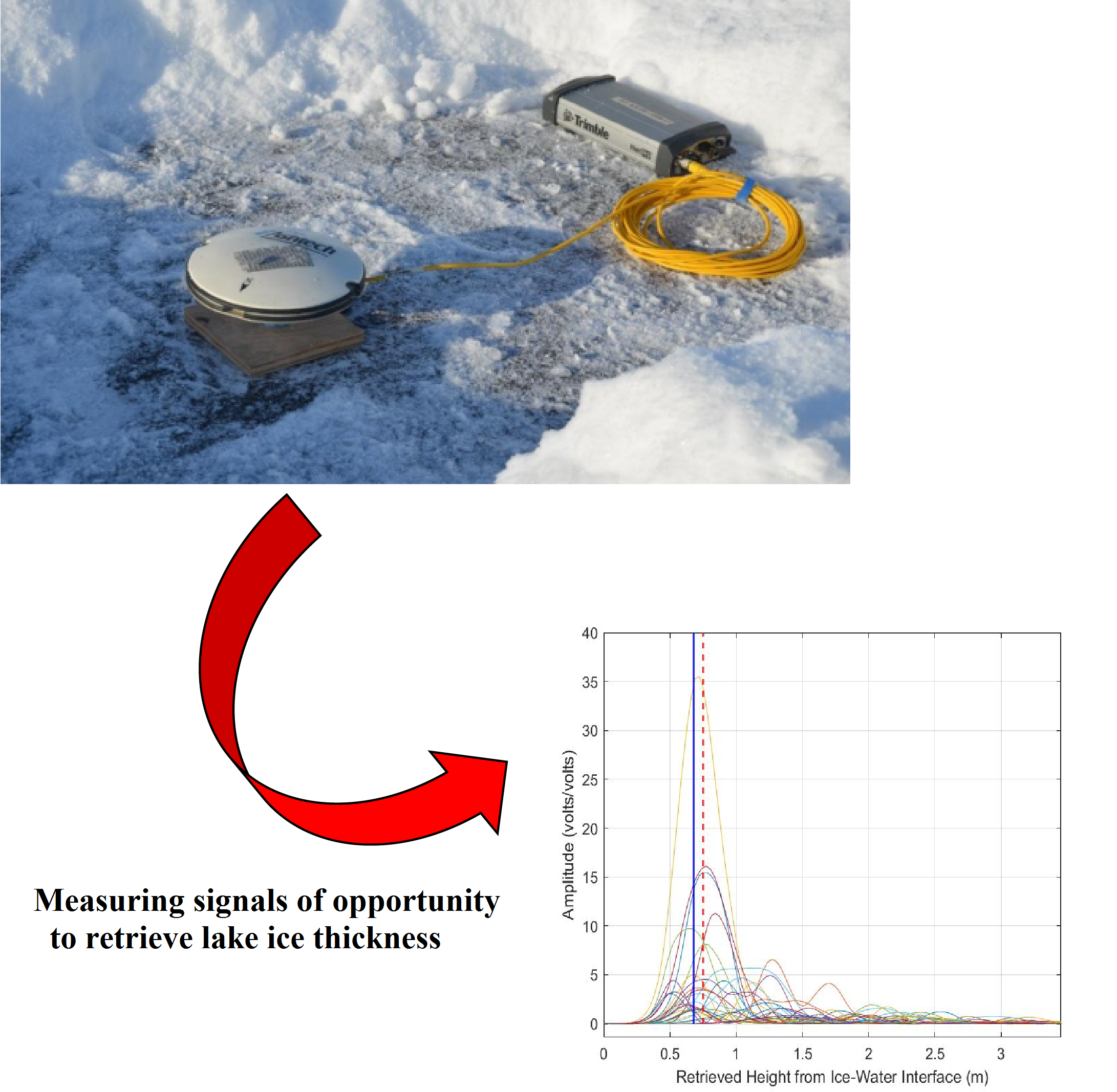
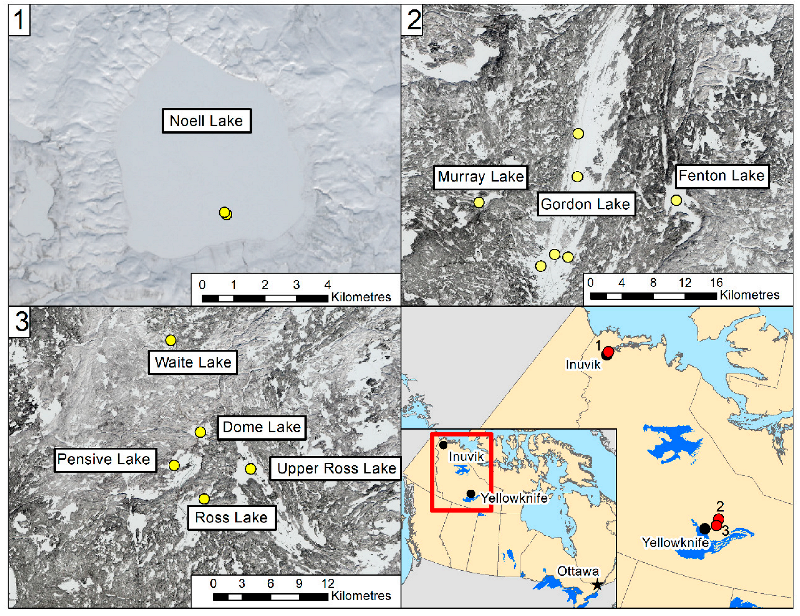
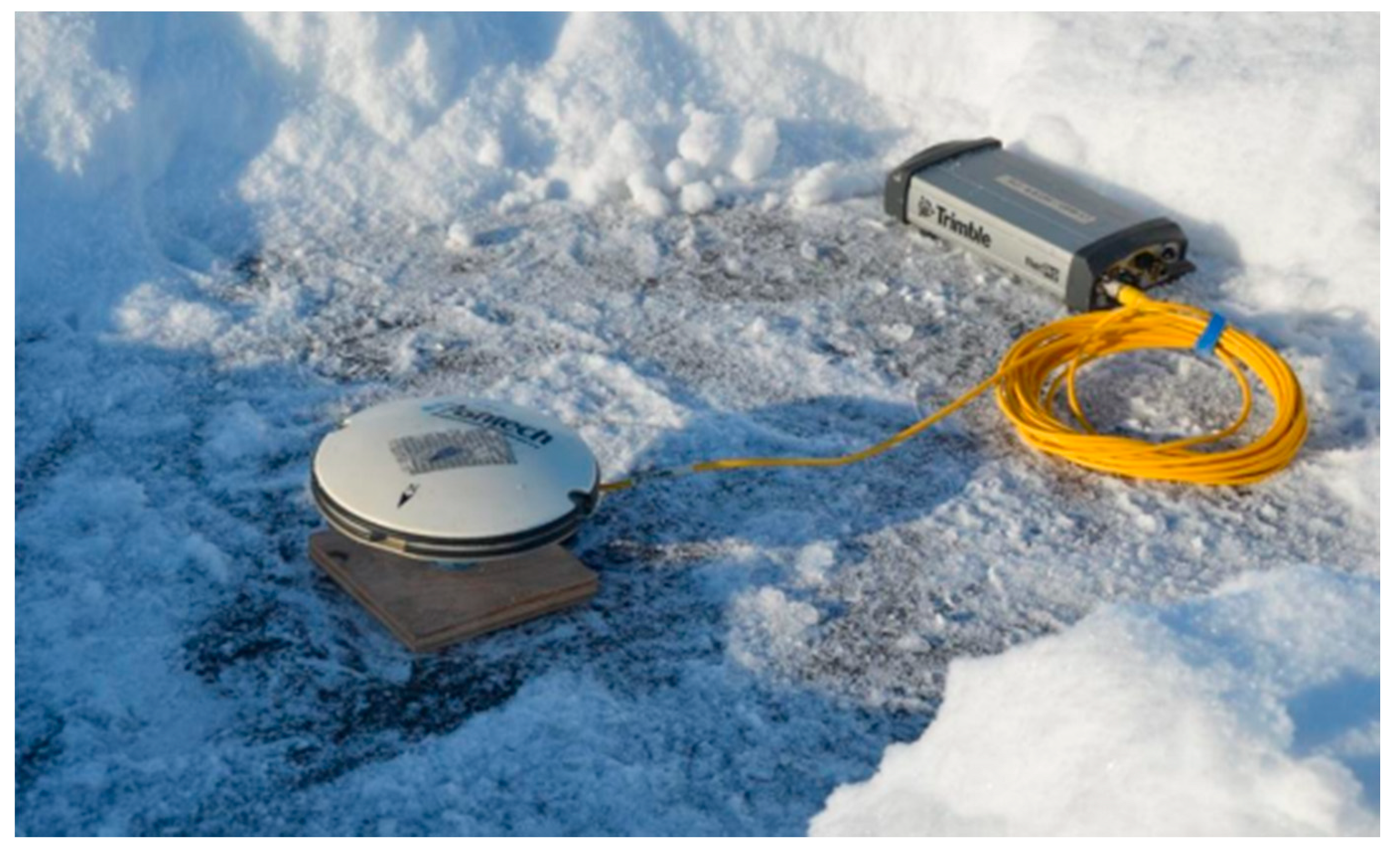
2.2. Experiment Setup
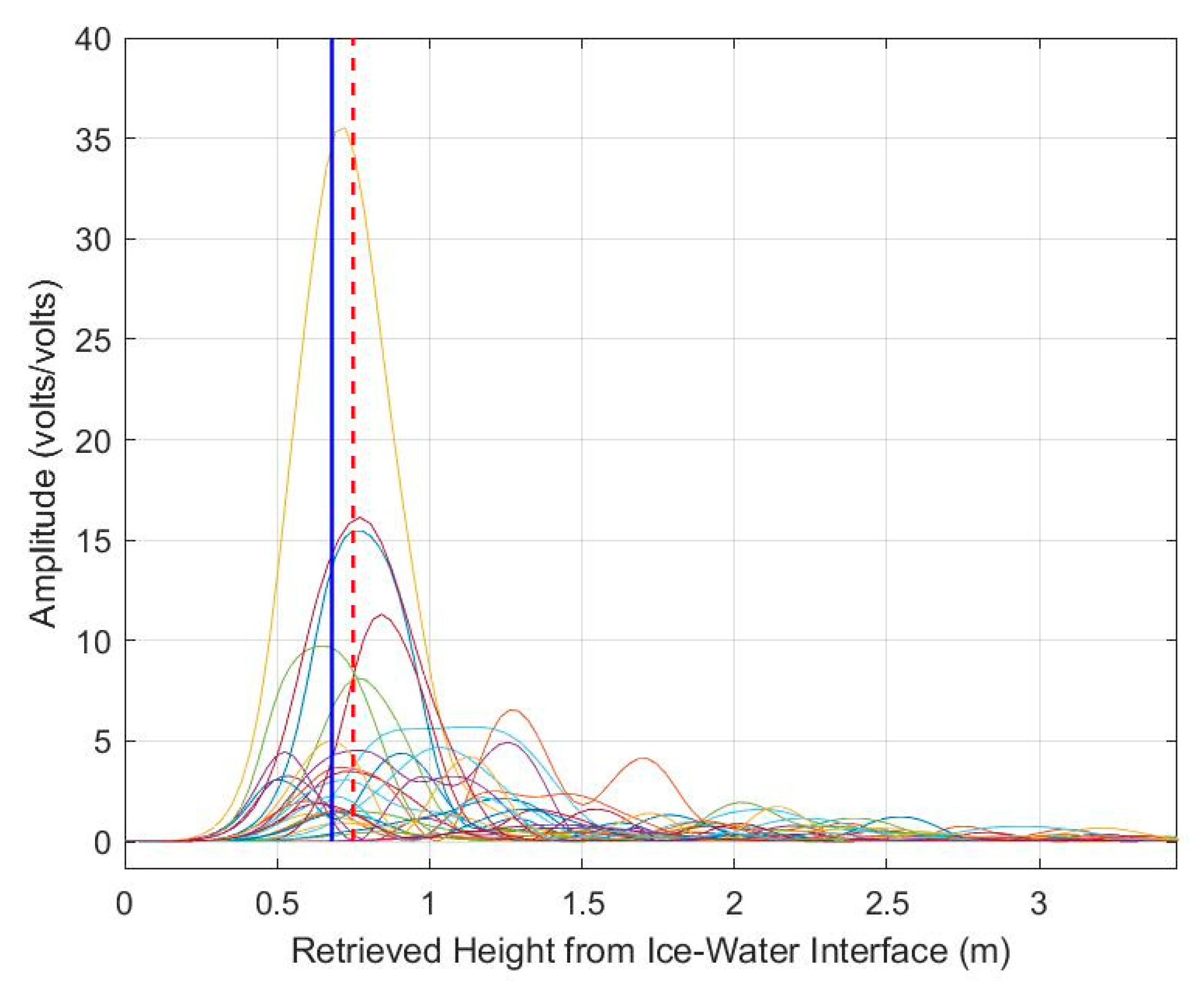
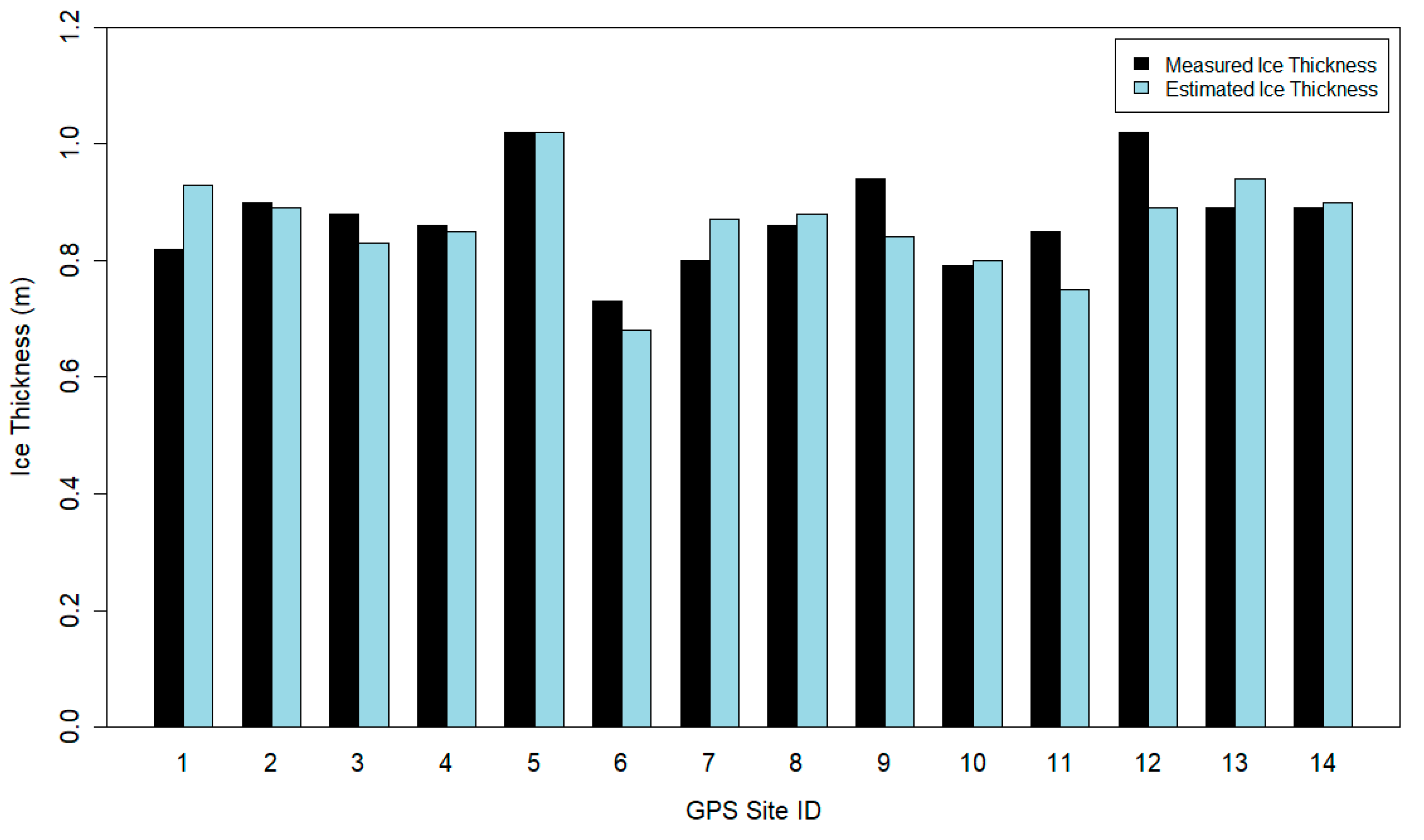
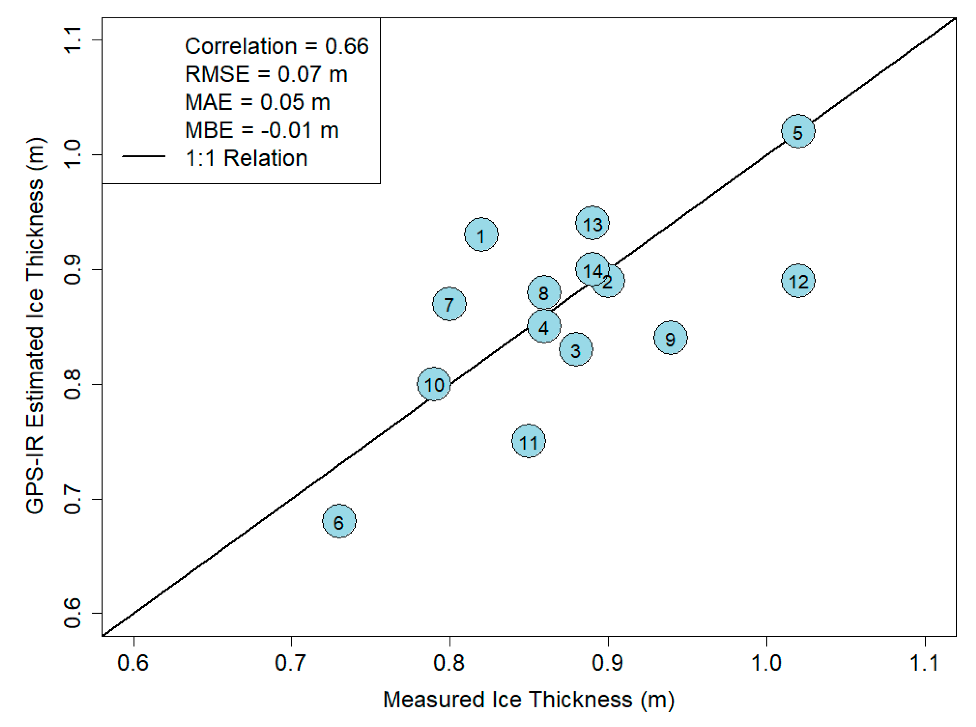
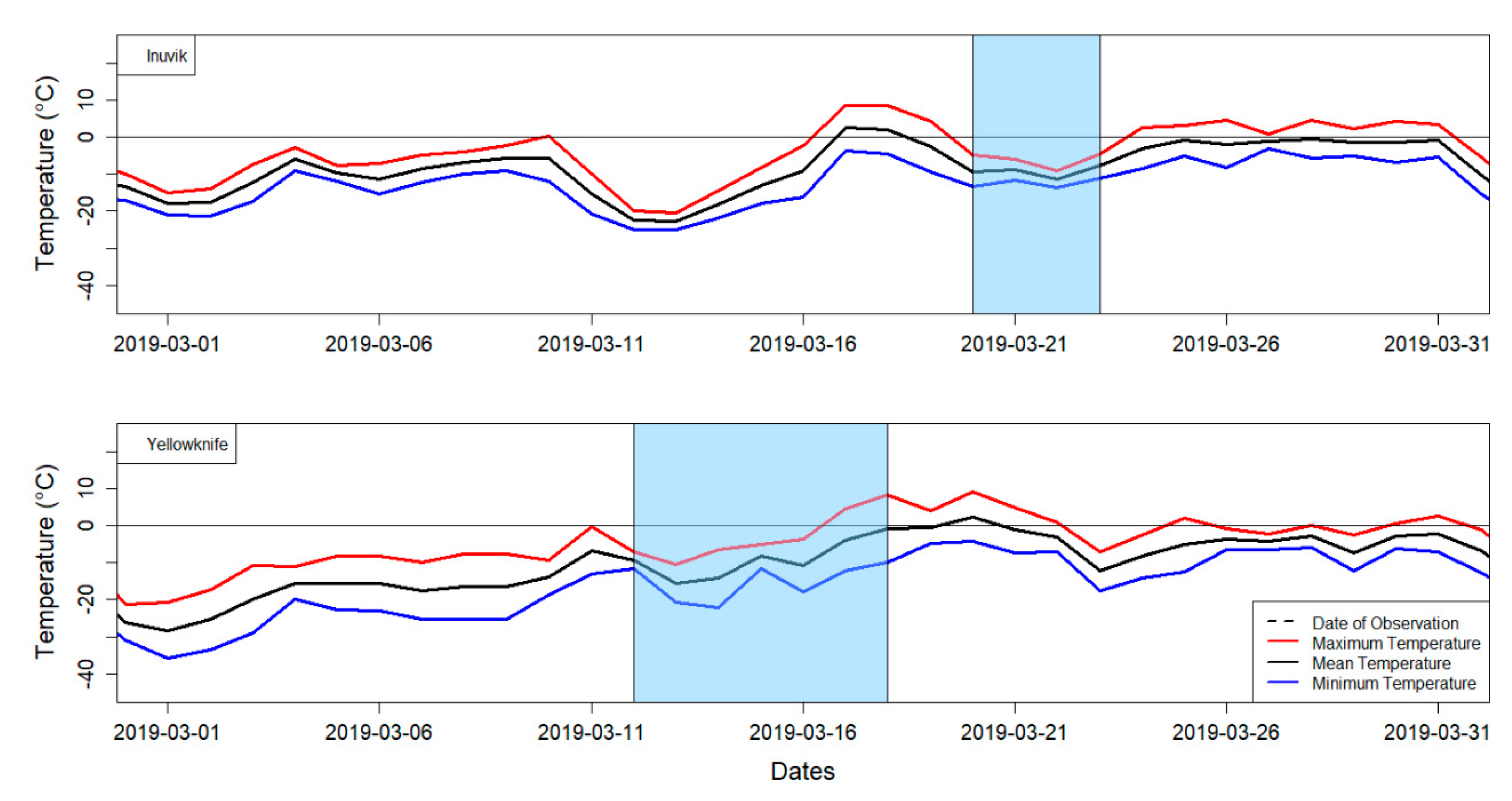
3. Results and Discussion
4. Conclusions and Future Work
Author Contributions
Funding
Acknowledgments
Conflicts of Interest
References
- Brown, L.C.; Duguay, C.R. The Response and Role of Ice Cover in Lake-Climate Interactions. Prog. Phys. Geogr. 2010, 34, 671–704. [Google Scholar] [CrossRef]
- Knoll, L.B.; Sharma, S.; Denfeld, B.A.; Flaim, G.; Hori, Y.; Magnuson, J.J.; Straile, D.; Weyhenmeyer, G.A. Consequences of Lake and River Ice Loss on Cultural Ecosystem Services. Limnol. Oceanogr. Lett. 2019, 4, 119–131. [Google Scholar] [CrossRef]
- Brown, L.C.; Duguay, C.R. A Comparison of Simulated and Measured Lake Ice Thickness Using a Shallow Water Ice Profiler. Hydrol. Process. 2011, 25, 2932–2941. [Google Scholar] [CrossRef]
- Murfitt, J.C.; Brown, L.C.; Howell, S.E.L. Estimating Lake Ice Thickness in Central Ontario. PLoS ONE 2018, 13, e0208519. [Google Scholar] [CrossRef]
- Gunn, G.E.; Duguay, C.R.; Brown, L.C.; King, J.; Atwood, D.; Kasurak, A. Freshwater Lake Ice Thickness Derived Using Surface-Based X- and Ku-Band FMCW Scatterometers. Cold Reg. Sci. Technol. 2015, 120, 115–126. [Google Scholar] [CrossRef]
- Kang, K.-K.; Duguay, C.R.; Lemmetyinen, J.; Gel, Y. Estimation of Ice Thickness on Large Northern Lakes from AMSR-E Brightness Temperature Measurements. Remote Sens. Environ. 2014, 150, 1–19. [Google Scholar] [CrossRef]
- Beckers, J.F.; Casey, J.A.; Haas, C. Retrievals of Lake Ice Thickness from Great Slave Lake and Great Bear Lake Using CryoSat-2. IEEE Trans. Geosci. Remote Sens. 2017, 55, 3708–3720. [Google Scholar] [CrossRef]
- Chew, C.C.; Small, E.E.; Larson, K.M.; Zavorotny, V.U. Effects of Near-Surface Soil Moisture on GPS SNR Data: Development of a Retrieval Algorithm for Soil Moisture. IEEE Trans. Geosci. Remote Sens. 2014, 52, 537–543. [Google Scholar] [CrossRef]
- Larson, K.M. GPS Interferometric Reflectometry: Applications to Surface Soil Moisture, Snow Depth, and Vegetation Water Content in the Western United States. WIRES Water 2016, 3, 775–787. [Google Scholar] [CrossRef]
- Strandberg, J.; Hobiger, T.; Haas, R. Coastal Sea Ice Detection Using Ground-Based GNSS-R. IEEE Geosci. Remote. Sens. Lett. 2016, 14, 1552–1556. [Google Scholar] [CrossRef]
- Jacobson, M.D. Snow-Covered Lake Ice in GPS Multipath Reception—Theory and Measurement. Adv. Space Res. 2010, 46, 221–227. [Google Scholar] [CrossRef]
- Jacobson, M.D. Potential for Estimating the Thickness of Freshwater Lake Ice by GPS Interferometric Reflectometry. J. Geogr. Geol. 2015, 7, 10–19. [Google Scholar] [CrossRef]
- Amiri-Simkooei, A.; Tiberius, C.; Teunissen, P. Assessment of Noise in GPS Coordinate Time Series: Methodology and Results. J. Geophys. Res. 2007, 112, B07413. [Google Scholar] [CrossRef]
- Cardellach, E.; Fabra, F.; Rius, A.; Pettinato, S.; D’Addio, S. Characterization of Dry-Snow Sub-Structure using GNSS Reflected Signals. Remote Sens. Environ. 2012, 124, 122–134. [Google Scholar] [CrossRef]
- Engram, M.; Anthony, K.W.; Meyer, F.J.; Grosse, G. Characterization of L-Band Synthetic Aperture Radar (SAR) Backscatter from Floating and Grounded Thermokarst Lake Ice in Arctic Alaska. Cryosphere 2013, 7, 1741–1752. [Google Scholar] [CrossRef]
- Zhou, W.; Liu, L.; Huang, L.; Yao, Y.; Chen, J.; Li, S. A new GPS SNR-based combination approach for land surface snow depth monitoring. Sci. Rep. 2019, 9, 1–20. [Google Scholar] [CrossRef]
- Roesler, C.; Larson, K.M. Software Tools for GNSS Interferometric Reflectometry (GNSS-IR). GPS Solut. 2018, 22, 80. [Google Scholar] [CrossRef]
- Environment and Climate Change Canada. Inuvik Climate Historical Daily Data 2017 and 2019. Available online: https://climate.weather.gc.ca/historical_data/search_historic_data_e.html (accessed on 26 March 2020).
- Environment and Climate Change Canada. Yellowknife Airport Historical Daily Data 2017 and 2019. Available online: https://climate.weather.gc.ca/historical_data/search_historic_data_e.html (accessed on 26 March 2020).
- Ariano, S.S.; Brown, L.C. Ice Processes on Medium-Sized North-Temperate Lakes. Hydrol. Process. 2019, 33, 2434–2448. [Google Scholar] [CrossRef]
- Larson, K.M.; MacFerrin, M.; Nylen, T. Brief Communication: Update on the GPS reflection technique for measuring snow accumulation in Greenland. Cryosphere 2020, 14, 1985–1988. [Google Scholar] [CrossRef]
- Alonso-Arroyo, A.; Camps, A.; Park, H.; Pascual, D.; Onrubia, R.; Martín, F. Retrieval of Significant Wave Height and Mean Sea Surface Level Using the GNSS-R Interference Pattern Technique: Results from a Three-Month Field Campaign. IEEE Trans. Geosci. Remote Sens. 2015, 53, 3198–3209. [Google Scholar] [CrossRef]
- Picard, G.; Sandells, M.; Löwe, H. SMRT: An Active-passive Microwave Radiative Transfer Model for Snow with Multiple Microstructure and Scattering Formulations (v1.0). Geosci. Model Dev. 2018, 11, 2763–2788. [Google Scholar] [CrossRef]


| GPS Site ID | Lake Name | Geographical Coordinates (Decimal Degrees) | Date | Measured Ice Thickness (m) | |
|---|---|---|---|---|---|
| Latitude | Longitude | ||||
| 1 | Gordon Lake | 63.04556 | −113.2169 | 9 March 2017 | 0.82 |
| 2 | Gordon Lake | 62.95611 | −113.2667 | 10 March 2017 | 0.90 |
| 3 | Gordon Lake | 63.09444 | −113.2186 | 8 March 2017 | 0.88 |
| 4 | Gordon Lake | 62.95361 | −113.2331 | 10 March 2017 | 0.86 |
| 5 | Gordon Lake | 62.9425 | −113.3003 | 14 March 2019 | 1.02 |
| 6 | Waite Lake | 62.8475 | −113.3236 | 16 March 2019 | 0.73 |
| 7 | Pensive Lake | 62.73028 | −113.3075 | 17 March 2019 | 0.80 |
| 8 | Murray Lake | 63.01222 | −113.4606 | 12 March 2019 | 0.86 |
| 9 | Ross Lake | 62.69942 | −113.24374 | 17 March 2019 | 0.94 |
| 10 | Dome Lake | 62.76222 | −113.2561 | 18 March 2019 | 0.79 |
| 11 | Fenton Lake | 63.02222 | −112.9669 | 14 March 2019 | 0.85 |
| 12 | Upper Ross Lake | 62.72933 | −113.15086 | 17 March 2019 | 1.02 |
| 13 | Noell Lake | 68.51149085 | −133.5497 | 21 March 2019 | 0.89 |
| 14 | Noell Lake | 68.51185952 | −133.551323 | 22 March 2019 | 0.89 |
© 2020 by the authors. Licensee MDPI, Basel, Switzerland. This article is an open access article distributed under the terms and conditions of the Creative Commons Attribution (CC BY) license (http://creativecommons.org/licenses/by/4.0/).
Share and Cite
Ghiasi, Y.; Duguay, C.R.; Murfitt, J.; van der Sanden, J.J.; Thompson, A.; Drouin, H.; Prévost, C. Application of GNSS Interferometric Reflectometry for the Estimation of Lake Ice Thickness. Remote Sens. 2020, 12, 2721. https://doi.org/10.3390/rs12172721
Ghiasi Y, Duguay CR, Murfitt J, van der Sanden JJ, Thompson A, Drouin H, Prévost C. Application of GNSS Interferometric Reflectometry for the Estimation of Lake Ice Thickness. Remote Sensing. 2020; 12(17):2721. https://doi.org/10.3390/rs12172721
Chicago/Turabian StyleGhiasi, Yusof, Claude R. Duguay, Justin Murfitt, Joost J. van der Sanden, Aaron Thompson, Hugo Drouin, and Christian Prévost. 2020. "Application of GNSS Interferometric Reflectometry for the Estimation of Lake Ice Thickness" Remote Sensing 12, no. 17: 2721. https://doi.org/10.3390/rs12172721
APA StyleGhiasi, Y., Duguay, C. R., Murfitt, J., van der Sanden, J. J., Thompson, A., Drouin, H., & Prévost, C. (2020). Application of GNSS Interferometric Reflectometry for the Estimation of Lake Ice Thickness. Remote Sensing, 12(17), 2721. https://doi.org/10.3390/rs12172721