A Robust Method for Generating High-Spatiotemporal-Resolution Surface Reflectance by Fusing MODIS and Landsat Data


 ,
,  ,
,  , and
, and
Abstract
:
1. Introduction
2. Methods
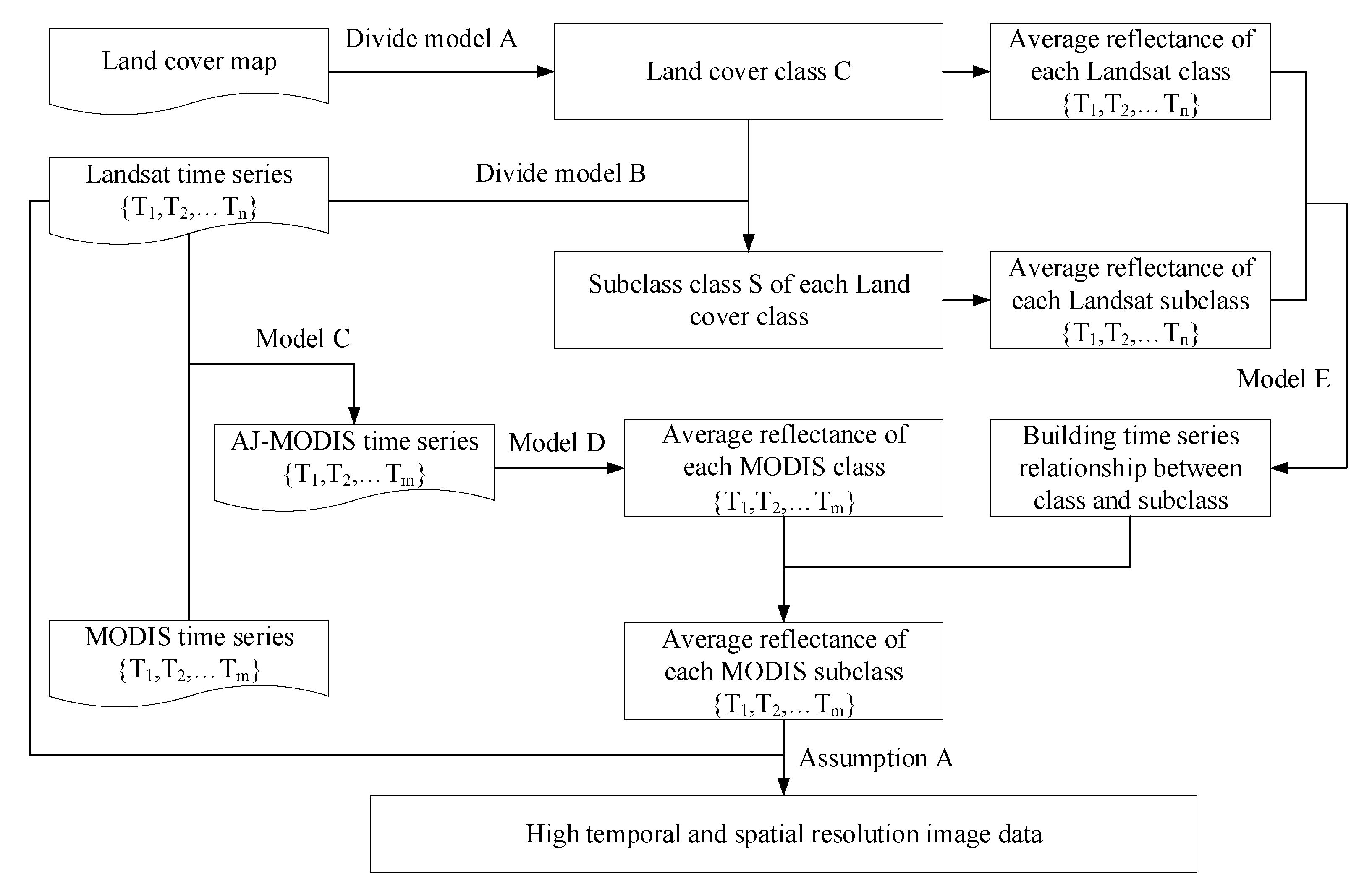
2.1. FCMSTRFM Logic
2.1.1. Class and Subclass Definition
2.1.2. Sensor-bias Adjustment
2.1.3. Class and Subclass Average Reflectance Calculation
2.1.4. Pixel Reflectance Calculation
2.2. Comparison with Other Fusion Methods
2.2.1. STDFA
2.2.2. ESTARFM
2.3. Evaluation Metrics
3. Experimental Data and Data Processing
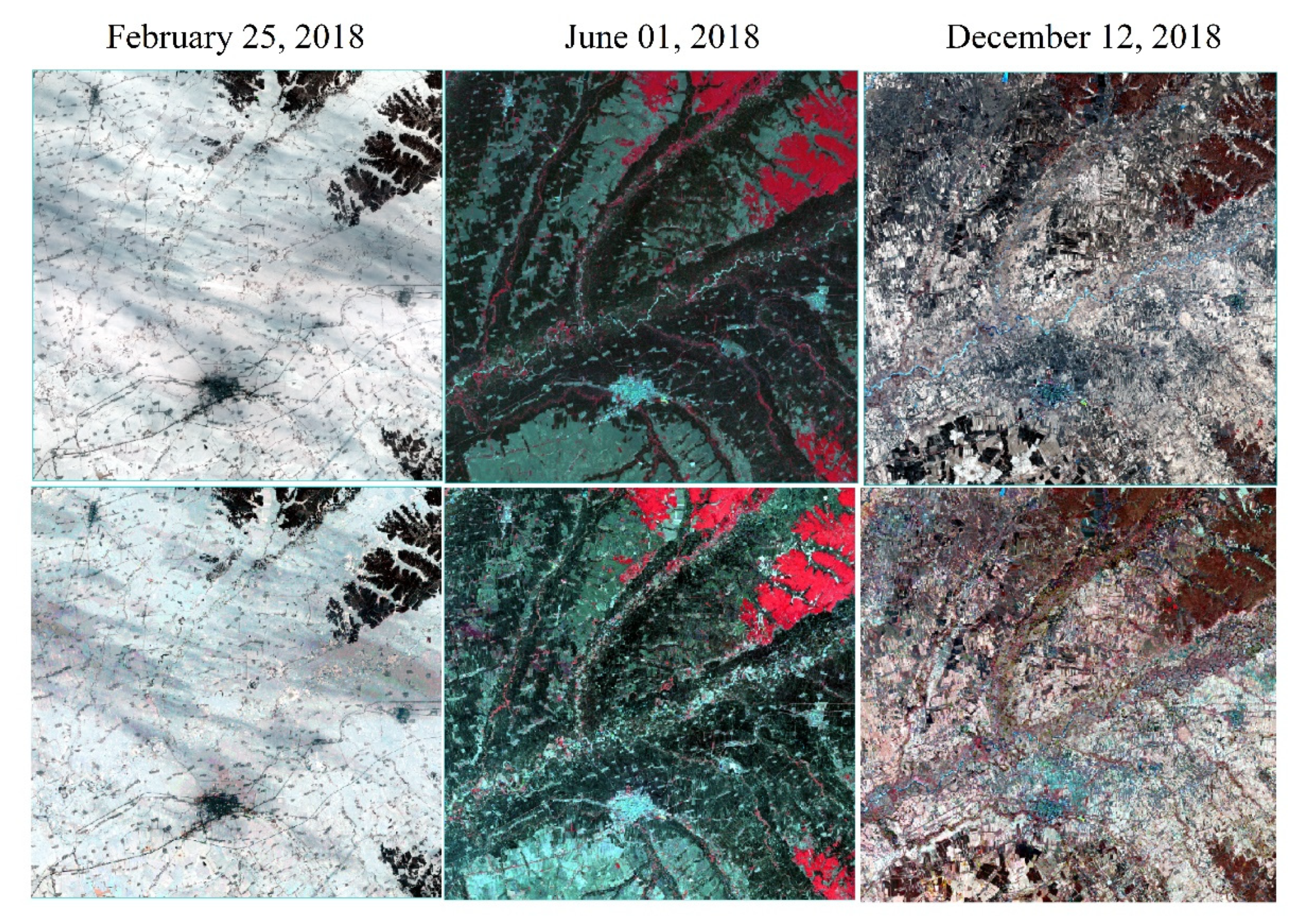
3.1. Study Area
3.2. Data Preprocessing
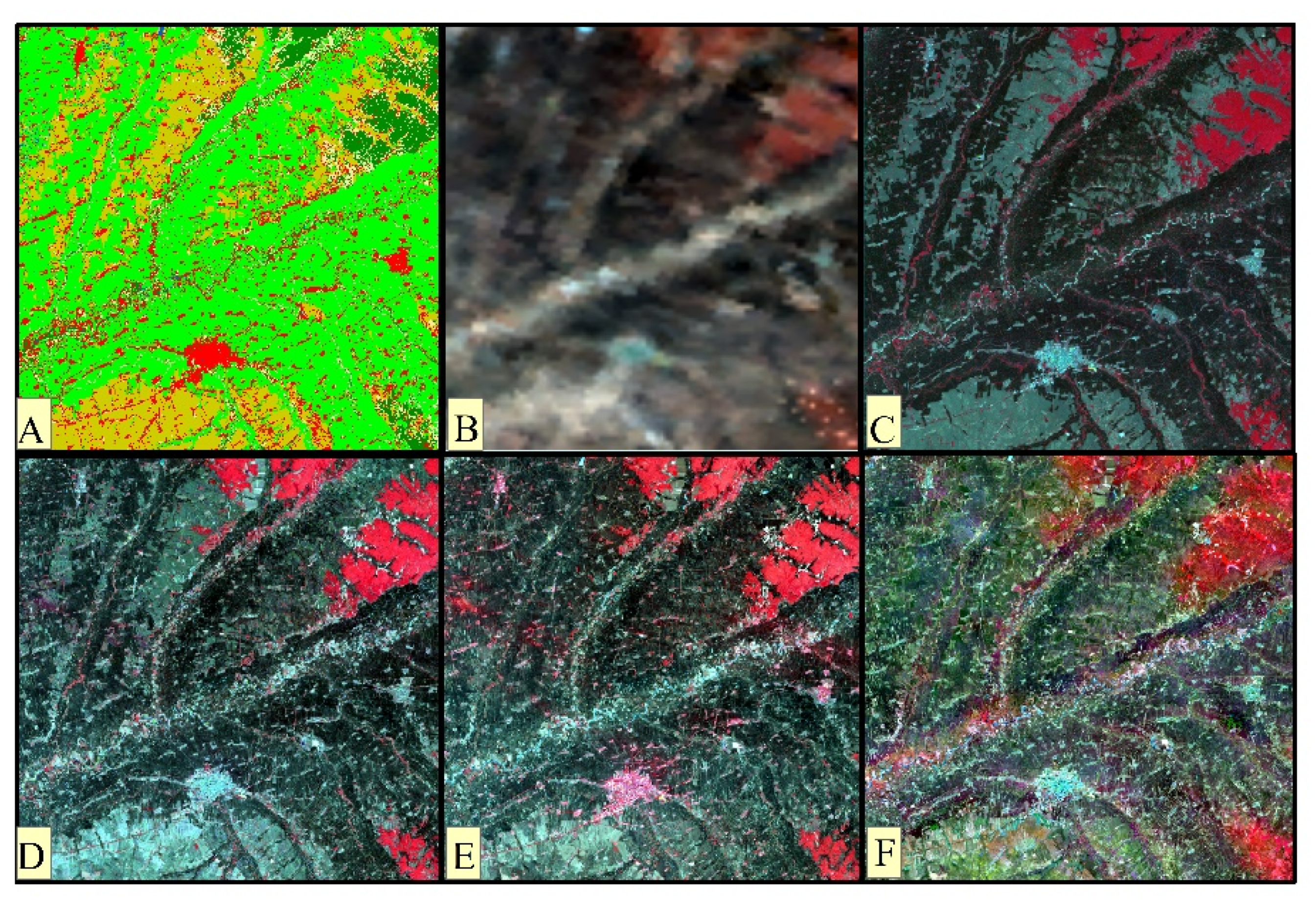
4. Results
4.1. Evaluation of the FCMSTRFM
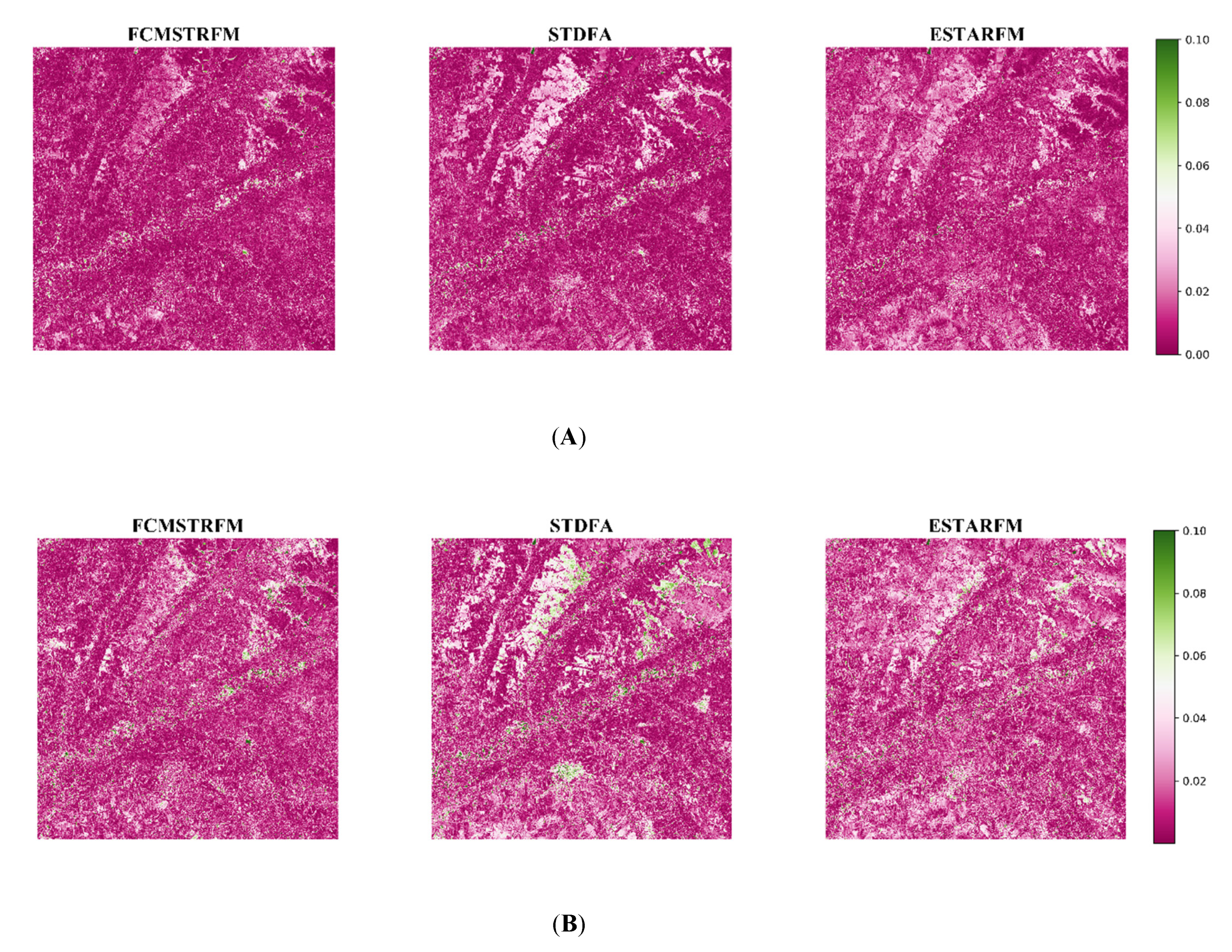
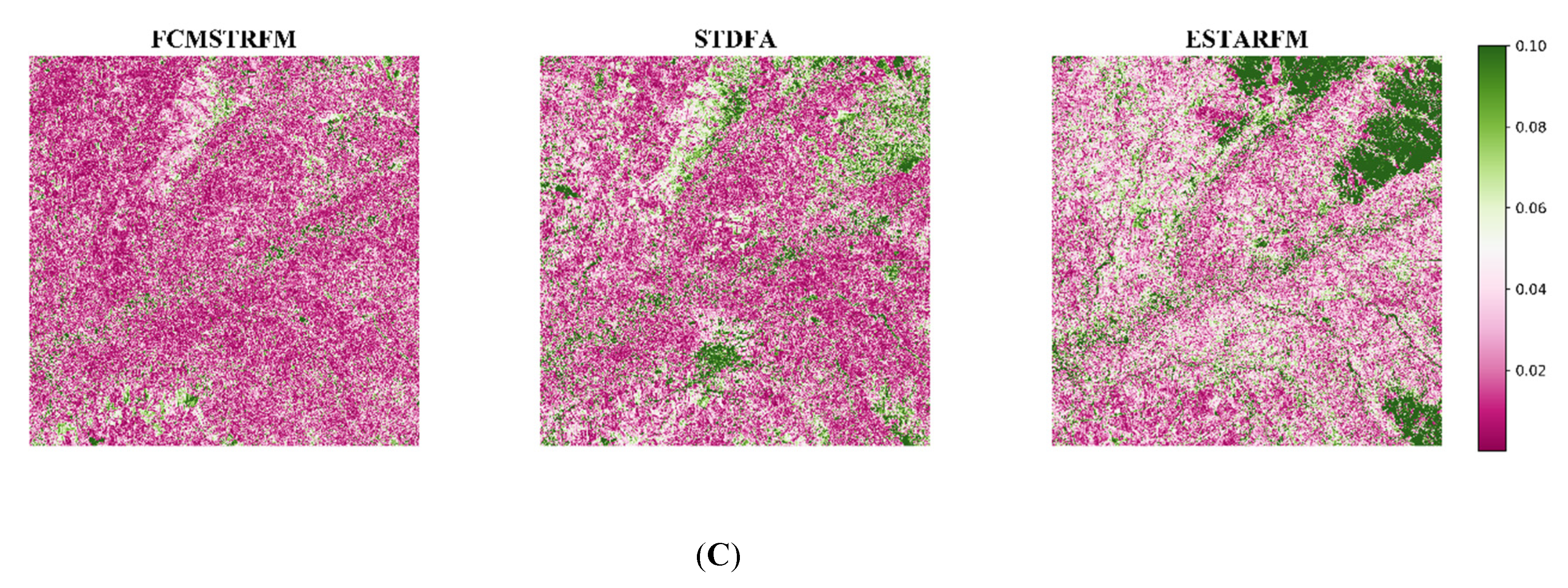
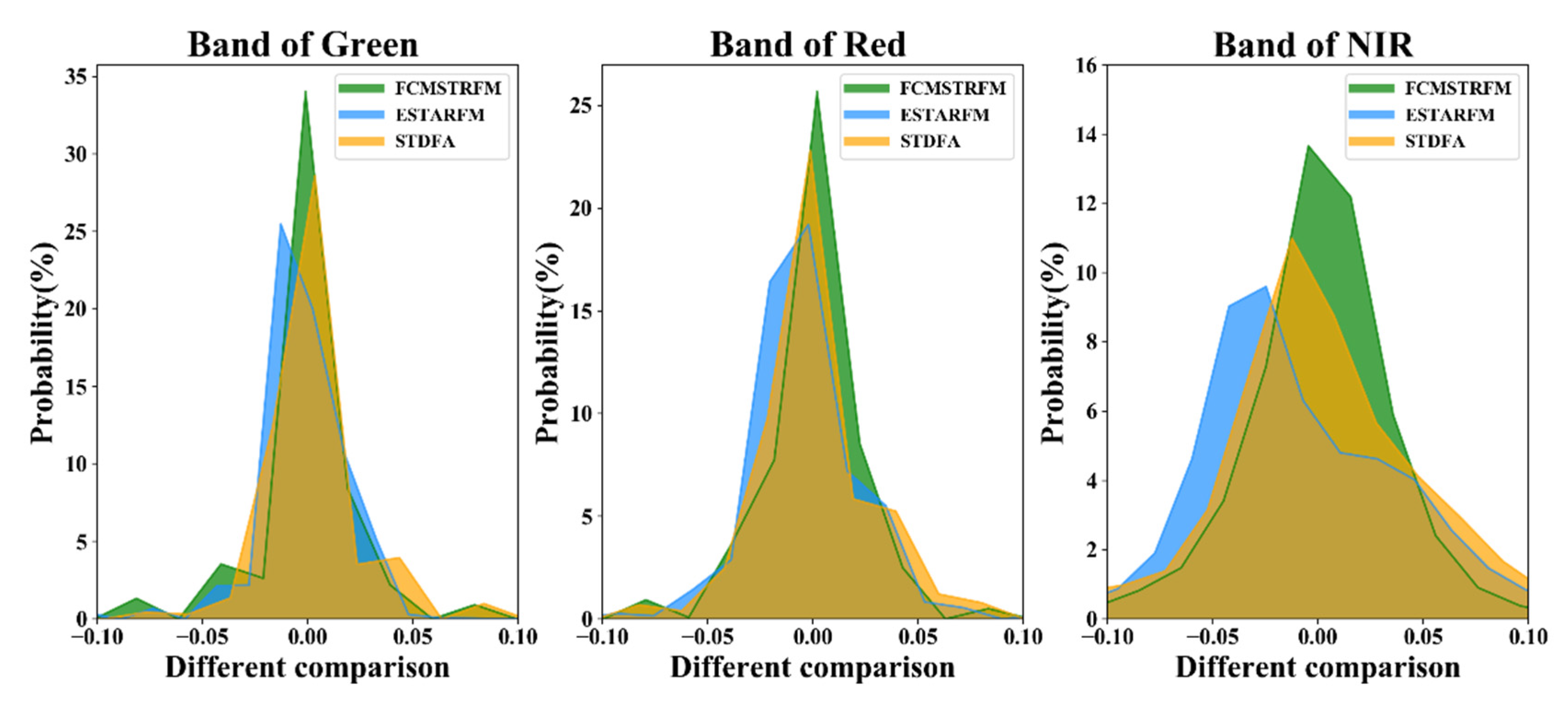
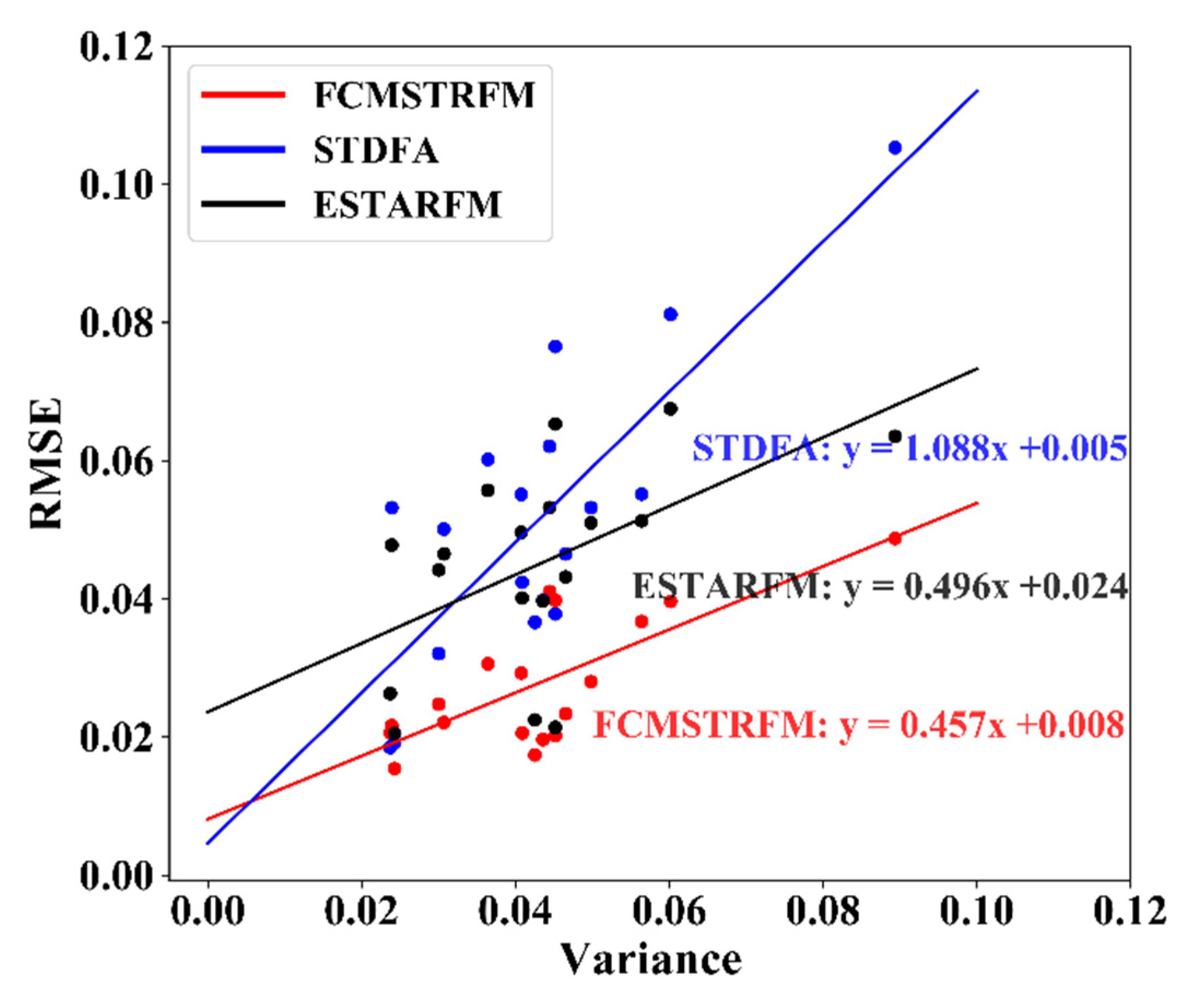
4.2. Comparison with Other Fusion Methods
5. Discussion
5.1. Uncertainties of the FCMSTRFM
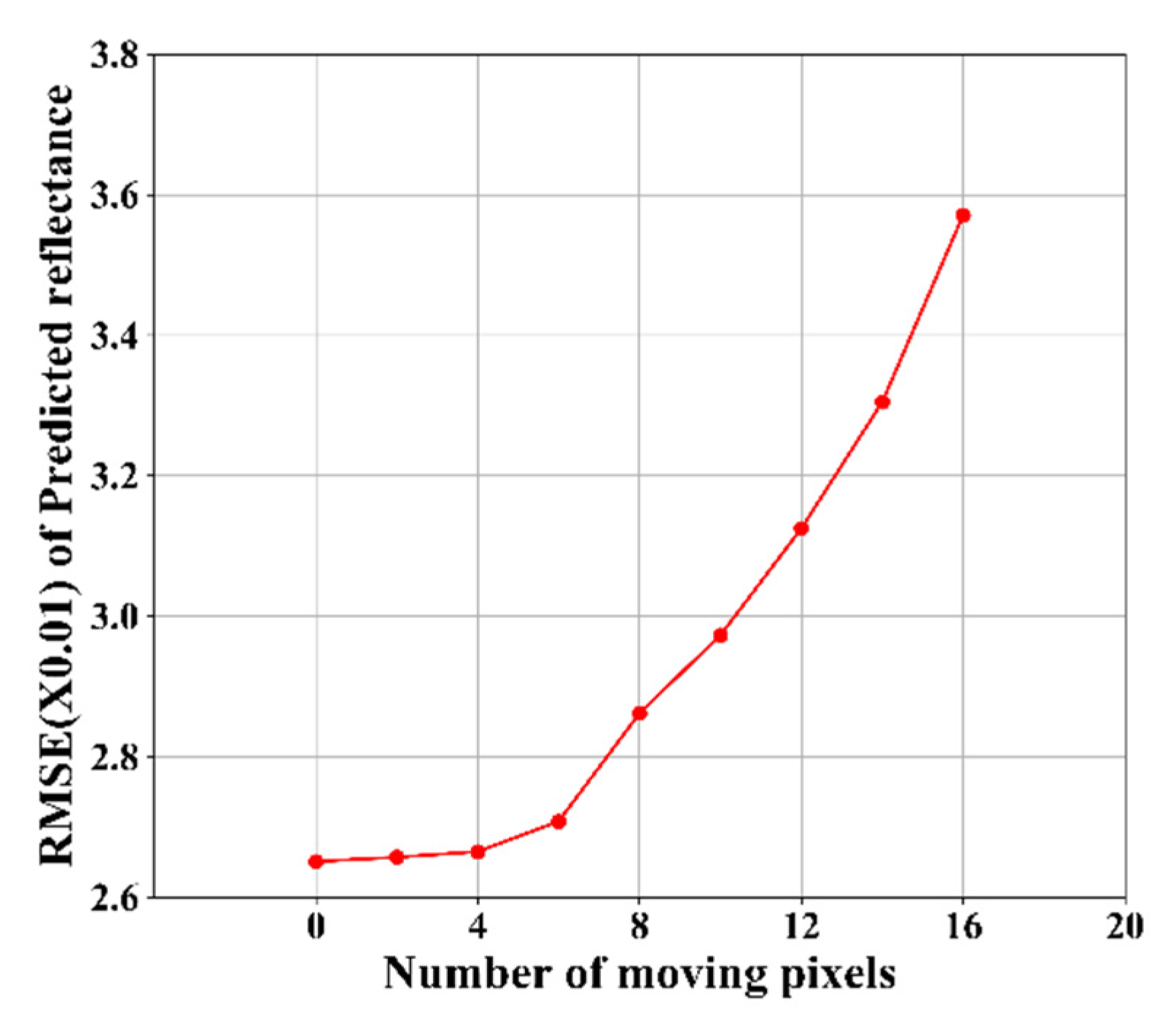
5.1.1. Influence of Image Registration
5.1.2. Influence of the Accuracy of the Land Cover Map
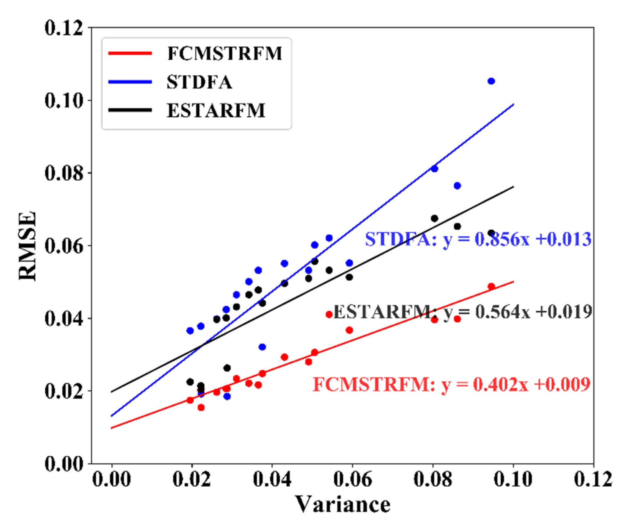
5.1.3. Influence of Temporal and Spatial Heterogeneity
5.2. FCMSTRFM Improvements to Existing Models
5.3. The Application of FCMSTRFM
6. Conclusions
Author Contributions
Funding
Acknowledgments
Conflicts of Interest
References
- Croft, H.; Anderson, K.; Kuhn, N.J. Evaluating the influence of surface soil moisture and soil surface roughness on optical directional reflectance factors. Eur. J. Soil Sci. 2014, 65, 605–612. [Google Scholar] [CrossRef]
- Cuppo, F.L.S.; Garcia-Valenzuela, A.; Olivares, J.A. Influence of surface roughness on the diffuse to near-normal viewing reflectance factor of coatings and its consequences on color measurements. Color Res. Appl. 2013, 38, 177–187. [Google Scholar] [CrossRef]
- Sun, Z.Q.; Wu, D.; Lv, Y.F.; Zhao, Y.S. Bidirectional Polarized Reflectance Factors of Vegetation Covers: Influence on the BRF Models Results. IEEE Trans. Geosci. Remote Sens. 2017, 55, 5687–5701. [Google Scholar] [CrossRef]
- Li, C.X.; Sun, Z.; Jiang, J.Y.; Liu, R.; Chen, W.L.; Xu, K.X. Typical ground object recognition based on principle component analysis and fuzzy clustering with near-infrared diffuse reflectance spectroscopy. Spectrosc. Spect. Anal. 2017, 37, 3386–3390. [Google Scholar]
- Zhong, L.H.; Hu, L.; Zhou, H.; Tao, X. Deep learning based winter wheat mapping using statistical data as ground references in Kansas and northern Texas, US. Remote Sens. Environ. 2019, 233. [Google Scholar] [CrossRef]
- Lee, T.Y.; Kaufman, Y.J. Non-lambertian effects on remote-sensing of surface reflectance and vegetation index. IEEE Trans. Geosci. Remote Sens. 1986, 24, 699–708. [Google Scholar] [CrossRef]
- Wang, H.; Yang, L.K.; Zhao, M.R.; Du, W.B.; Liu, P.; Sun, X.B. The normalized difference vegetation index and angular variation of surface spectral polarized reflectance relationships: Improvements on aerosol remote sensing over land. Earth Space Sci. 2019, 6, 982–989. [Google Scholar] [CrossRef] [Green Version]
- Spanner, M.A.; Pierce, L.L.; Peterson, D.L.; Running, S.W. Remote-sensing of temperate coniferous forest leaf-area index—The influence of canopy closure, understory vegetation and background reflectance. Int. J. Remote Sens. 1990, 11, 95–111. [Google Scholar] [CrossRef]
- Zhai, H.; Huang, F.; Qi, H. Generating High Resolution LAI Based on a modified FSDAF model. Remote Sens. 2020, 12, 150. [Google Scholar] [CrossRef] [Green Version]
- Ma, R.; Zhang, L.; Tian, X.J.; Zhang, J.C.; Yuan, W.P.; Zheng, Y.; Zhao, X.; Kato, T. Assimilation of remotely-sensed leaf area index into a dynamic vegetation model for gross primary productivity estimation. Remote Sens. 2017, 9, 188. [Google Scholar] [CrossRef] [Green Version]
- Zheng, Y.; Zhang, L.; Xiao, J.F.; Yuan, W.P.; Yan, M.; Li, T.; Zhang, Z.Q. Sources of uncertainty in gross primary productivity simulated by light use efficiency models: Model structure, parameters, input data, and spatial resolution. Agric. For. Meteorol. 2018, 263, 242–257. [Google Scholar] [CrossRef]
- Merlin, O.; Chirouze, J.; Olioso, A.; Jarlan, L.; Chehbouni, G.; Boulet, G. An image-based four-source surface energy balance model to estimate crop evapotranspiration from solar reflectance/thermal emission data (SEB-4S). Agric. For. Meteorol. 2014, 184, 188–203. [Google Scholar] [CrossRef] [Green Version]
- Xu, J.; Yao, Y.J.; Liang, S.L.; Liu, S.M.; Fisher, J.B.; Jia, K.; Zhang, X.T.; Lin, Y.; Zhang, L.L.; Chen, X.W. Merging the MODIS and landsat terrestrial latent heat flux products using the multiresolution tree method. IEEE Trans. Geosci. Remote Sens. 2019, 57, 2811–2823. [Google Scholar] [CrossRef]
- Yao, Y.J.; Qin, Q.M.; Ghulam, A.; Liu, S.M.; Zhao, S.H.; Xu, Z.W.; Dong, H. Simple method to determine the Priestley-Taylor parameter for evapotranspiration estimation using Albedo-VI triangular space from MODIS data. J. Appl. Remote Sens. 2011, 5. [Google Scholar] [CrossRef]
- Goswami, S.; Gamon, J.A.; Tweedie, C.E. Surface hydrology of an arctic ecosystem: Multiscale analysis of a flooding and draining experiment using spectral reflectance. J. Geophys. Res. Biogeosci. 2011, 116. [Google Scholar] [CrossRef]
- Jin, J.; Wang, Q.; Wang, J.L.; Otieno, D. Tracing water and energy fluxes and reflectance in an arid ecosystem using the integrated model SCOPE. J. Environ. Manag. 2019, 231, 1082–1090. [Google Scholar] [CrossRef] [PubMed]
- Yao, Y.; Liang, S.; Li, X.; Chen, J.; Wang, K.; Jia, K.; Cheng, J.; Jiang, B.; Fisher, J.B.; Mu, Q.; et al. Asatellite-based hybrid algorithm to determine the Priestley–Taylor parameter for global terrestrial latent heat flux estimation across multiple biomes. Remote Sens. Environ. 2015, 165, 216–233. [Google Scholar] [CrossRef]
- Yao, Y.J.; Liang, S.L.; Qin, Q.M.; Wang, K.C. Monitoring drought over the conterminous United States using MODIS and NCEP reanalysis-2 data. J. Appl. Meteorol. Clim. 2010, 49, 1665–1680. [Google Scholar] [CrossRef]
- Xue, J.; Leung, Y.; Fung, T. An unmixing-based bayesian model for spatio-temporal satellite image fusion in heterogeneous landscapes. Remote Sens. 2019, 11, 324. [Google Scholar] [CrossRef] [Green Version]
- Gevaert, C.M.; Garcia-Haro, F.J. A comparison of STARFM and an unmixing-based algorithm for Landsat and MODIS data fusion. Remote Sens. Environ. 2015, 156, 34–44. [Google Scholar] [CrossRef]
- Emelyanova, I.V.; McVicar, T.R.; Van Niel, T.G.; Li, L.T.; van Dijk, A.I.J.M. Assessing the accuracy of blending Landsat-MODIS surface reflectances in two landscapes with contrasting spatial and temporal dynamics: A framework for algorithm selection. Remote Sens. Environ. 2013, 133, 193–209. [Google Scholar] [CrossRef]
- Gao, F.; Masek, J.; Schwaller, M.; Hall, F. On the blending of the Landsat and MODIS surface reflectance: Predicting daily Landsat surface reflectance. IEEE Trans. Geosci. Remote Sens. 2006, 44, 2207–2218. [Google Scholar]
- Sun, R.; Chen, S.H.; Su, H.B.; Mi, C.R.; Jin, N. The Effect of NDVI time series density derived from spatiotemporal fusion of multisource remote sensing data on crop classification accuracy. ISPRS Int. J. Geo-Inf. 2019, 8, 502. [Google Scholar] [CrossRef] [Green Version]
- Ehlers, M. Multisensor image fusion techniques in remote-sensing. ISPRS J. Photogramm. Remote Sens. 1991, 46, 19–30. [Google Scholar] [CrossRef] [Green Version]
- Hilker, T.; Wulder, M.A.; Coops, N.C.; Linke, J.; McDermid, G.; Masek, J.G.; Gao, F.; White, J.C. A new data fusion model for high spatial-and temporal-resolution mapping of forest disturbance based on Landsat and MODIS. Remote Sens. Environ. 2009, 113, 1613–1627. [Google Scholar] [CrossRef]
- Wang, T.; Tang, R.L.; Li, Z.L.; Jiang, Y.Z.; Liu, M.; Niu, L. An Improved spatio-temporal adaptive data fusion algorithm for evapotranspiration mapping. Remote Sens. 2019, 11, 761. [Google Scholar] [CrossRef] [Green Version]
- Xia, H.P.; Chen, Y.H.; Li, Y.; Quan, J.L. Combining kernel-driven and fusion-based methods to generate daily high-spatial-resolution land surface temperatures. Remote Sens. Environ. 2019, 224, 259–274. [Google Scholar] [CrossRef]
- Zhu, X.L.; Chen, J.; Gao, F.; Chen, X.H.; Masek, J.G. An enhanced spatial and temporal adaptive reflectance fusion model for complex heterogeneous regions. Remote Sens. Environ. 2010, 114, 2610–2623. [Google Scholar] [CrossRef]
- Cui, J.T.; Zhang, X.; Luo, M.Y. Combining linear pixel unmixing and STARFM for spatiotemporal fusion of gaofen-1 wide field of view imagery and MODIS imagery. Remote Sens. 2018, 10, 1047. [Google Scholar] [CrossRef] [Green Version]
- Roy, D.P.; Ju, J.; Lewis, P.; Schaaf, C.; Gao, F.; Hansen, M.; Lindquist, E. Multi-temporal MODIS-Landsat data fusion for relative radiometric normalization, gap filling, and prediction of Landsat data. Remote Sens. Environ. 2008, 112, 3112–3130. [Google Scholar] [CrossRef]
- Walker, J.J.; de Beurs, K.M.; Wynne, R.H.; Gao, F. Evaluation of Landsat and MODIS data fusion products for analysis of dryland forest phenology. Remote Sens. Environ. 2012, 117, 381–393. [Google Scholar] [CrossRef]
- Xie, D.F.; Zhang, J.S.; Zhu, X.F.; Pan, Y.Z.; Liu, H.L.; Yuan, Z.M.Q.; Yun, Y. An improved STARFM with help of an unmixing-based method to generate high spatial and temporal resolution remote sensing data in complex heterogeneous regions. Sensors 2016, 16, 207. [Google Scholar] [CrossRef] [PubMed] [Green Version]
- Wu, M.Q.; Wu, C.Y.; Huang, W.J.; Niu, Z.; Wang, C.Y.; Li, W.; Hao, P.Y. An improved high spatial and temporal data fusion approach for combining Landsat and MODIS data to generate daily synthetic Landsat imagery. Inform. Fusion 2016, 31, 14–25. [Google Scholar] [CrossRef]
- Liu, M.; Yang, W.; Zhu, X.L.; Chen, J.; Chen, X.H.; Yang, L.Q.; Helmer, E.H. An Improved Flexible Spatiotemporal DAta Fusion (IFSDAF) method for producing high spatiotemporal resolution normalized difference vegetation index time series. Remote Sens. Environ. 2019, 227, 74–89. [Google Scholar] [CrossRef]
- Wu, M.Q.; Niu, Z.; Wang, C.Y.; Wu, C.Y.; Wang, L. Use of MODIS and Landsat time series data to generate high-resolution temporal synthetic Landsat data using a spatial and temporal reflectance fusion model. J. Appl. Remote Sens. 2012, 6. [Google Scholar] [CrossRef]
- Zurita-Milla, R.; Kaiser, G.; Clevers, J.G.P.W.; Schneider, W.; Schaepman, M.E. Downscaling time series of MERIS full resolution data to monitor vegetation seasonal dynamics. Remote Sens. Environ. 2009, 113, 1874–1885. [Google Scholar] [CrossRef]
- Zhong, D.T.; Zhou, F.Q. Improvement of clustering methods for modelling abrupt land surface changes in satellite image fusions. Remote Sens. 2019, 11, 1759. [Google Scholar] [CrossRef] [Green Version]
- Zurita-Milla, R.; Clevers, J.G.P.W.; Schdepman, M.E. Unmixing-based Landsat TM and MERIS FR data fusion. IEEE Trans. Geosci. Remote Sens. 2008, 5, 453–457. [Google Scholar] [CrossRef] [Green Version]
- Zhukov, B.; Oertel, D.; Lanzl, F.; Reinhackel, G. Unmixing-based multisensor multiresolution image fusion. IEEE Trans. Geosci. Remote Sens. 1999, 37, 1212–1226. [Google Scholar] [CrossRef]
- Maselli, F. Definition of spatially variable spectral endmembers by locally calibrated multivariate regression analyses. Remote Sens. Environ. 2001, 75, 29–38. [Google Scholar] [CrossRef]
- Zurita-Milla, R.; Gomez-Chova, L.; Guanter, L.; Clevers, J.G.P.W.; Camps-Valls, G. Multitemporal unmixing of medium-spatial-resolution satellite images: A case study using MERIS images for land-cover mapping. IEEE Trans. Geosci. Remote Sens. 2011, 49, 4308–4317. [Google Scholar] [CrossRef]
- Comber, A.J.; Law, A.N.R.; Lishman, J.R. Application of knowledge for automated land cover change monitoring. Int. J. Remote Sens. 2004, 25, 3177–3192. [Google Scholar] [CrossRef] [Green Version]
- Hansen, M.C.; Defries, R.S.; Townshend, J.R.G.; Sohlberg, R. Global land cover classification at 1 km spatial resolution using a classification tree approach. Int. J. Remote Sens. 2000, 21, 1331–1364. [Google Scholar] [CrossRef]
- King, R.B. Land cover mapping principles: A return to interpretation fundamentals. Int. J. Remote Sens. 2002, 23, 3525–3545. [Google Scholar] [CrossRef]
- Jokinen, J.; Raty, T.; Lintonen, T. Clustering structure analysis in time-series data with density-based clusterability measure. IEEE/CAA J. Autom. Sin. 2019, 6, 1332–1343. [Google Scholar] [CrossRef]
- Wang, Y.; Ru, Y.N.; Chai, J.P. Time series clustering based on sparse subspace clustering algorithm and its application to daily box-office data analysis. Neural Comput. Appl. 2019, 31, 4809–4818. [Google Scholar] [CrossRef]
- Zhang, L.; Weng, Q.H.; Shao, Z.F. An evaluation of monthly impervious surface dynamics by fusing Landsat and MODIS time series in the Pearl River Delta, China, from 2000 to 2015. Remote Sens. Environ. 2017, 201, 99–114. [Google Scholar] [CrossRef]
- Bezdek, J.C.; Ehrlich, R.; Full, W. FCM—The Fuzzy C-Means Clustering-Algorithm. Comput. Geosci. UK 1984, 10, 191–203. [Google Scholar] [CrossRef]
- Rodriguez, A.; Tomas, M.S.; Rubio-Martinez, J. A benchmark calculation for the fuzzy c-means clustering algorithm: Initial memberships. J. Math. Chem. 2012, 50, 2703–2715. [Google Scholar] [CrossRef]
- Saxena, A.; Prasad, M.; Gupta, A.; Bharill, N.; Patel, O.P.; Tiwari, A.; Er, M.J.; Ding, W.P.; Lin, C.T. A review of clustering techniques and developments. Neurocomputing 2017, 267, 664–681. [Google Scholar] [CrossRef] [Green Version]
- Garcia-Haro, F.J.; Sommer, S.; Kemper, T. A new tool for variable multiple endmember spectral mixture analysis (VMESMA). Int J. Remote Sens. 2005, 26, 2135–2162. [Google Scholar] [CrossRef] [Green Version]
- Yang, J.M.; Wu, Y.; Wei, Y.X.; Wang, B.; Ru, C.; Ma, Y.Y.; Zhang, Y. A model for the fusion of multi-source data to generate high temporal and spatial resolution VI data. J. Remote Sens. 2019, 23, 935–943. [Google Scholar] [CrossRef]
- Jin, X.; Jin, Y.X.; Yuan, D.H.; Mao, X.F. Effects of land-use data resolution on hydrologic modelling, a case study in the upper reach of the Heihe River, Northwest China. Ecol. Model. 2019, 404, 61–68. [Google Scholar] [CrossRef]
- Pokonieczny, K.; Moscicka, A. The Influence of the shape and size of the cell on developing military passability maps. ISPRS Int. J. Geo-Inf. 2018, 7, 261. [Google Scholar] [CrossRef] [Green Version]
- Weigand, M.; Staab, J.; Wurm, M.; Taubenbock, H. Spatial and semantic effects of LUCAS samples on fully automated land use/land cover classification in high-resolution Sentinel-2 data. Int J. Appl. Earth Obs. Geoinf. 2020, 88. [Google Scholar] [CrossRef]
- Joshi, N.; Baumann, M.; Ehammer, A.; Fensholt, R.; Grogan, K.; Hostert, P.; Jepsen, M.R.; Kuemmerle, T.; Meyfroidt, P.; Mitchard, E.T.A.; et al. A review of the application of optical and radar remote sensing data fusion to land use mapping and monitoring. Remote Sens. 2016, 8, 70. [Google Scholar] [CrossRef] [Green Version]
- Lei, G.B.; Li, A.N.; Bian, J.H.; Zhang, Z.J. The roles of criteria, data and classification methods in designing land cover classification systems: Evidence from existing land cover data sets. Int. J. Remote Sens. 2020, 41, 5062–5082. [Google Scholar] [CrossRef]
- Xu, G.; Zhang, H.R.; Chen, B.Z.; Zhang, H.F.; Yan, J.W.; Chen, J.; Che, M.L.; Lin, X.F.; Dou, X.M. A Bayesian based method to generate a synergetic land-cover map from existing land-cover products. Remote Sens. 2014, 6, 5589–5613. [Google Scholar] [CrossRef] [Green Version]
- Liu, Y.L.; Wang, X.M.; Liu, Q.L.; Chen, Y.Y.; Liu, L.L. An improved density-based time series clustering method based on image resampling: A case study of surface deformation pattern analysis. ISPRS Int. J. Geo-Inf. 2017, 6, 118. [Google Scholar] [CrossRef]
- Wei, Y.X.; Yang, J.M.; Wu, Y.; Wang, B.; Shaban, M.; Hou, J.X. Rice planting area extraction based on multi-source data fusion. Trans. Chin. Soc. Agric. Mach. 2018, 49, 300–306. [Google Scholar]


| Image | Path/Row | Acquisition Date/DOY |
|---|---|---|
| Landsat | 117/027 | 11/04/2017,17/08/2017, 02/09/2017, 04/10/2017 25/02/2018, 29/03/2018, 30/04/2018,01/06/2018, 07/10/2018, 20/12/2018 |
| MOD09GA | h25/v04 | 11/04/2017,17/08/2017, 02/09/2017, 04/10/2017 25/02/2018, 29/03/2018, 30/04/2018,01/06/2018, 07/10/2018, 20/12/2018 |
| MOD13Q1 | h25/v04 | 11/04/2017,17/08/2017, 02/09/2017, 04/10/2017 |
| Landsat8 OLI | MODIS | ||||
|---|---|---|---|---|---|
| Band | Bandwidth (μm) | Spatial Resolution (m) | Band | Bandwidth (μm) | Spatial Resolution (m) |
| 1 | 0.433–0.453 | 30 | 9 | 0.438–0.448 | 1000 |
| 2 | 0.450–0.515 | 30 | 3 | 0.459–0.479 | 500 |
| 3 | 0.525–0.600 | 30 | 4 | 0.545–0.565 | 500 |
| 4 | 0.630–0.680 | 30 | 1 | 0.620–0.670 | 250 |
| 5 | 0.845–0.885 | 30 | 2 | 0.841–0.876 | 250 |
| 6 | 1.560–1.660 | 30 | 6 | 1.628–1.652 | 500 |
| 7 | 2.100–2.300 | 30 | 7 | 2.105–2.155 | 500 |
| 8 | 0.500–0.680 | 15 | - | - | - |
| 9 | 1.360–1.390 | 30 | 26 | 1.360–1.390 | 1000 |
| 10 | 10.60–11.19 | 100 | 31 | 10.780–11.280 | 1000 |
| 11 | 11.50–12.51 | 100 | 32 | 11.770–12.270 | 1000 |
| Time | Band | R | RMSE | MAD | ERGAS |
|---|---|---|---|---|---|
| 30/4/2018 | Green | 0.7857 | 0.018 | 0.0129 | 1.7107 |
| Red | 0.7914 | 0.0271 | 0.0214 | 2.0703 | |
| NIR | 0.8432 | 0.0382 | 0.0282 | 1.7697 | |
| 1/6/2018 | Green | 0.8331 | 0.0163 | 0.0112 | 1.6398 |
| Red | 0.8483 | 0.0227 | 0.0159 | 2.2883 | |
| NIR | 0.9459 | 0.0385 | 0.0273 | 1.4883 |
| Time | Band | STDFA | ESTARFM | ||||||
|---|---|---|---|---|---|---|---|---|---|
| R | RMSE | MAD | ERGAS | R | RMSE | MAD | ERGAS | ||
| 30/4/2018 | Green | 0.7357 | 0.0197 | 0.0138 | 2.873 | 0.8288 | 0.0241 | 0.0191 | 2.2861 |
| Red | 0.748 | 0.0261 | 0.0191 | 2.994 | 0.7966 | 0.0378 | 0.028 | 2.8837 | |
| NIR | 0.7993 | 0.0407 | 0.031 | 2.884 | 0.807 | 0.0617 | 0.0424 | 2.8592 | |
| 1/6/2018 | Green | 0.7158 | 0.0194 | 0.0129 | 1.9585 | 0.6778 | 0.0184 | 0.0138 | 1.8528 |
| Red | 0.7094 | 0.0275 | 0.0193 | 2.7683 | 0.7513 | 0.025 | 0.0189 | 2.5191 | |
| NIR | 0.8913 | 0.0512 | 0.0377 | 1.9769 | 0.6919 | 0.0738 | 0.0524 | 2.8495 | |
| Band | STDFA | FCM | FCMSTRFM |
|---|---|---|---|
| B3 | 0.0137 | 0.0067 | 0.0059 |
| B4 | 0.0111 | 0.0078 | 0.0064 |
| B5 | 0.0084 | 0.0035 | 0.0022 |
| VI-DOY | R | RMSE | ERGAS | Variance |
|---|---|---|---|---|
| NDVI-229 | 0.9305 | 0.0607 | 1.7132 | 0.0037 |
| NDVI-245 | 0.9028 | 0.0721 | 1.9655 | 0.0052 |
| EVI-229 | 0.9154 | 0.0622 | 1.9547 | 0.0038 |
| EVI-245 | 0.8744 | 0.0748 | 2.2849 | 0.0055 |
© 2020 by the authors. Licensee MDPI, Basel, Switzerland. This article is an open access article distributed under the terms and conditions of the Creative Commons Attribution (CC BY) license (http://creativecommons.org/licenses/by/4.0/).
Share and Cite
Yang, J.; Yao, Y.; Wei, Y.; Zhang, Y.; Jia, K.; Zhang, X.; Shang, K.; Bei, X.; Guo, X. A Robust Method for Generating High-Spatiotemporal-Resolution Surface Reflectance by Fusing MODIS and Landsat Data. Remote Sens. 2020, 12, 2312. https://doi.org/10.3390/rs12142312
Yang J, Yao Y, Wei Y, Zhang Y, Jia K, Zhang X, Shang K, Bei X, Guo X. A Robust Method for Generating High-Spatiotemporal-Resolution Surface Reflectance by Fusing MODIS and Landsat Data. Remote Sensing. 2020; 12(14):2312. https://doi.org/10.3390/rs12142312
Chicago/Turabian StyleYang, Junming, Yunjun Yao, Yongxia Wei, Yuhu Zhang, Kun Jia, Xiaotong Zhang, Ke Shang, Xiangyi Bei, and Xiaozheng Guo. 2020. "A Robust Method for Generating High-Spatiotemporal-Resolution Surface Reflectance by Fusing MODIS and Landsat Data" Remote Sensing 12, no. 14: 2312. https://doi.org/10.3390/rs12142312
APA StyleYang, J., Yao, Y., Wei, Y., Zhang, Y., Jia, K., Zhang, X., Shang, K., Bei, X., & Guo, X. (2020). A Robust Method for Generating High-Spatiotemporal-Resolution Surface Reflectance by Fusing MODIS and Landsat Data. Remote Sensing, 12(14), 2312. https://doi.org/10.3390/rs12142312