TROPOMI NO2 Tropospheric Column Data: Regridding to 1 km Grid-Resolution and Assessment of their Consistency with In Situ Surface Observations


Abstract

1. Introduction
2. Materials and Methods
2.1. TROPOMI NO2 Observations
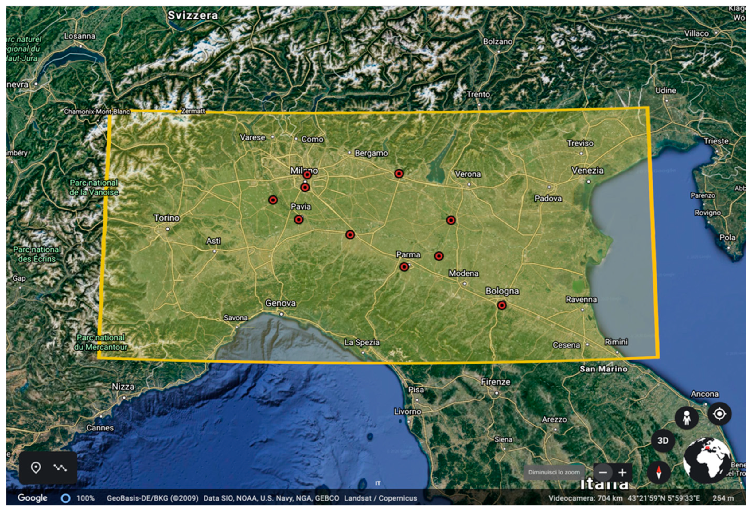
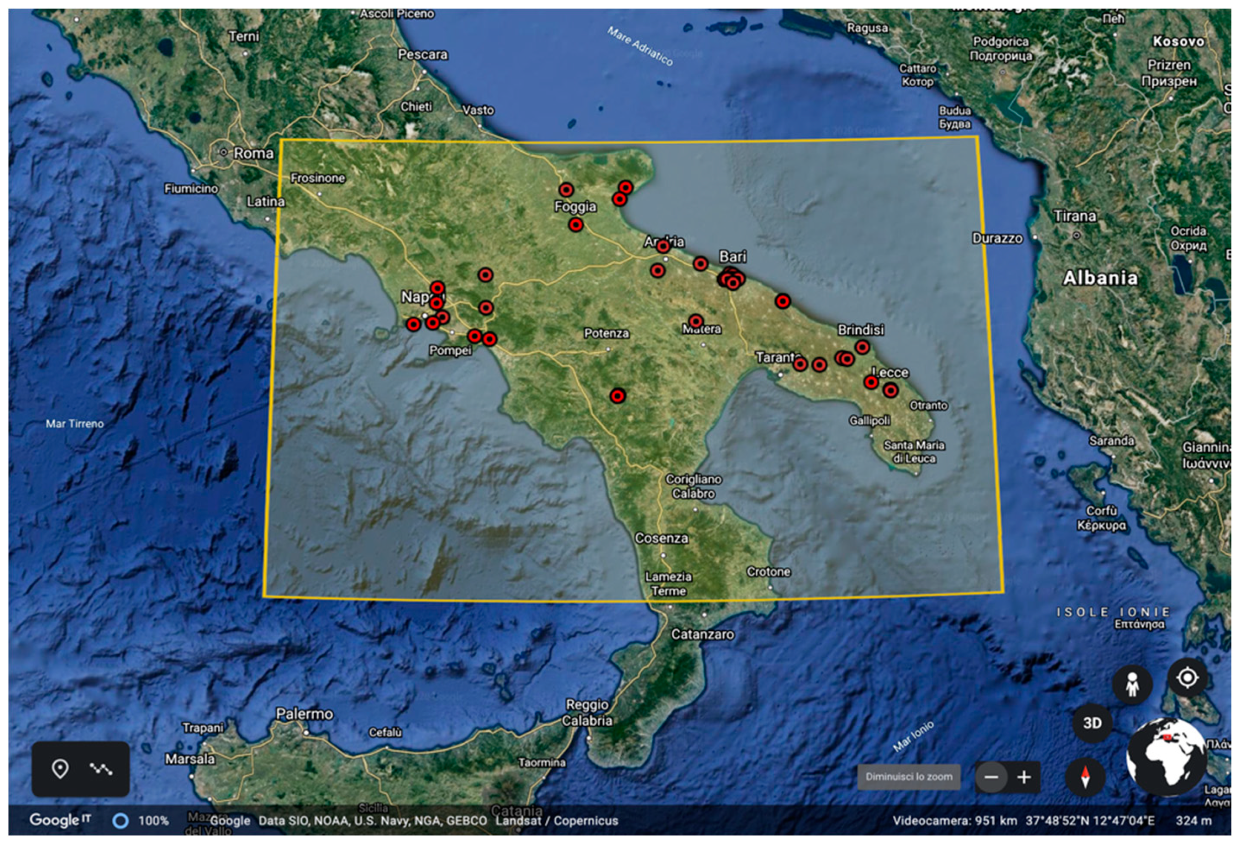
2.2. Ground-Based Observations
2.3. Averaging and Remapping Operations
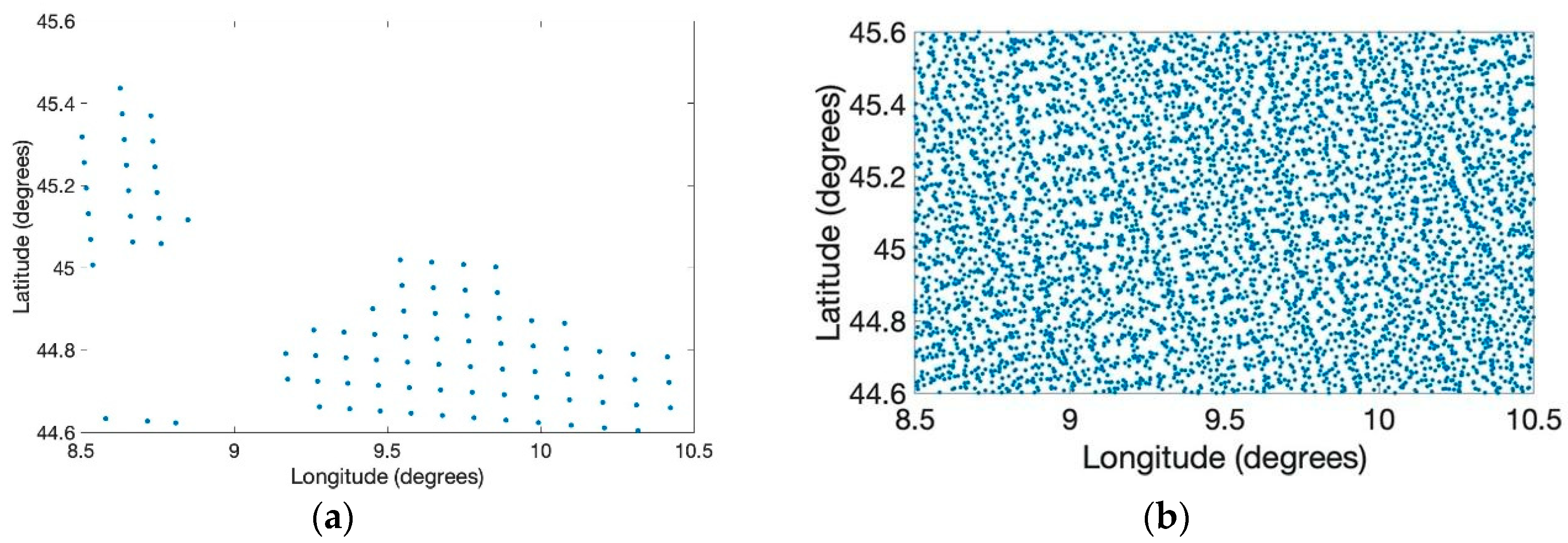
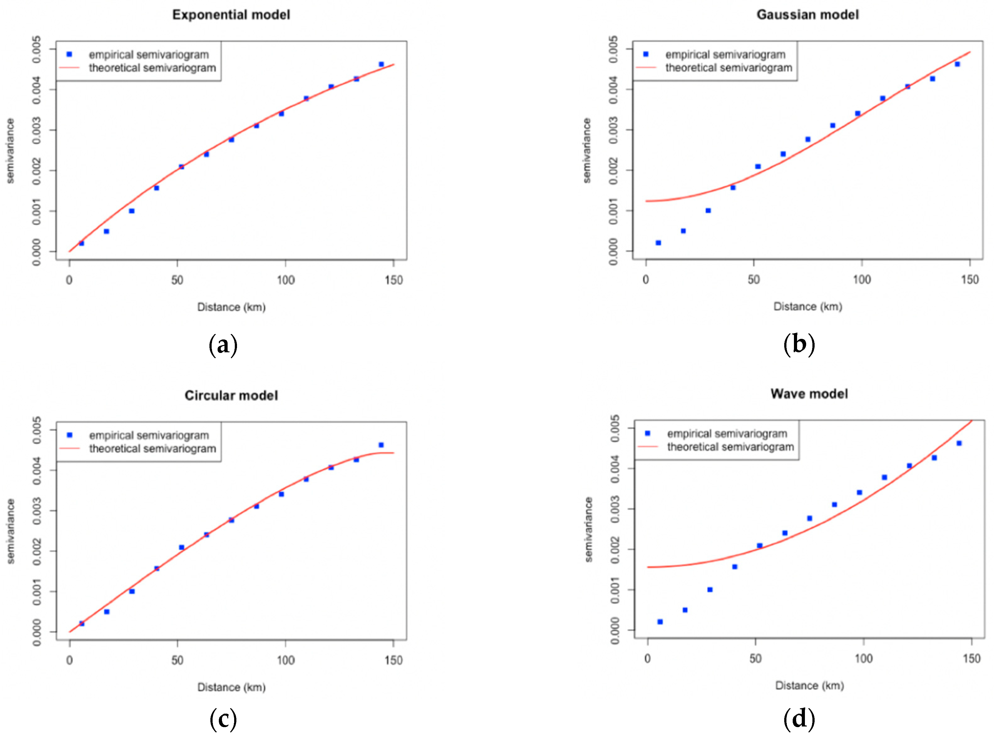
2.4. Regridding Technique
3. Results
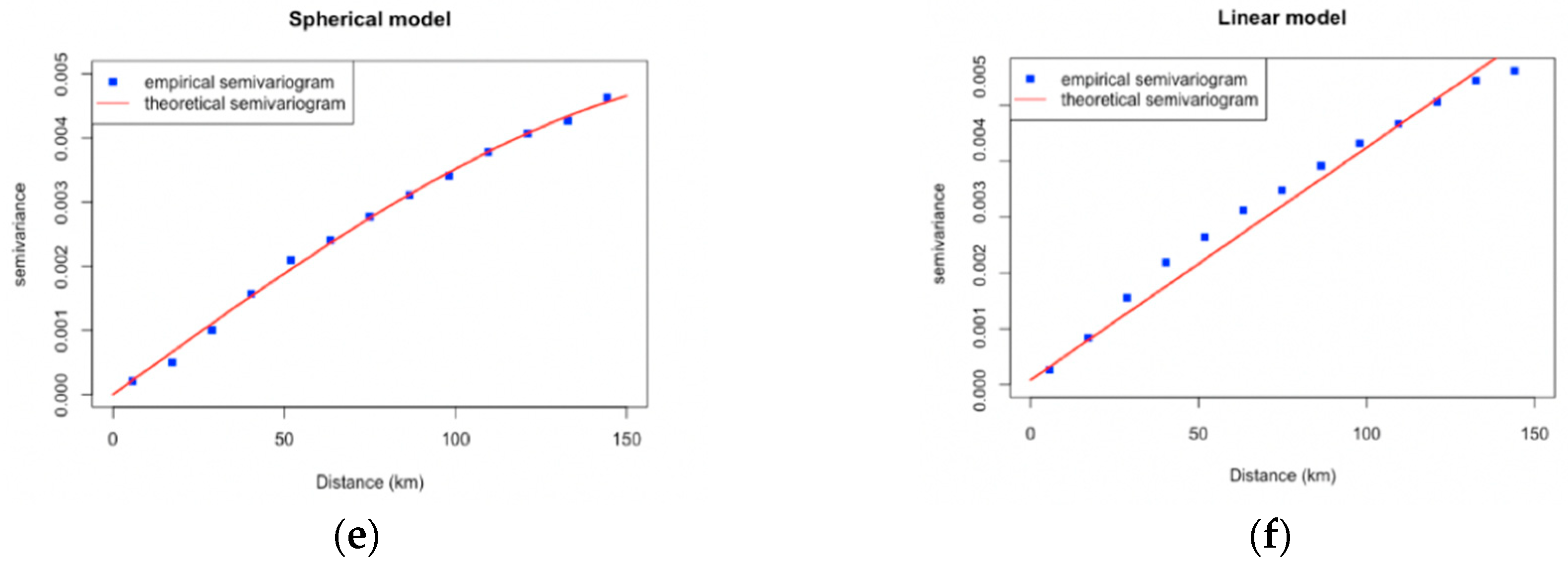
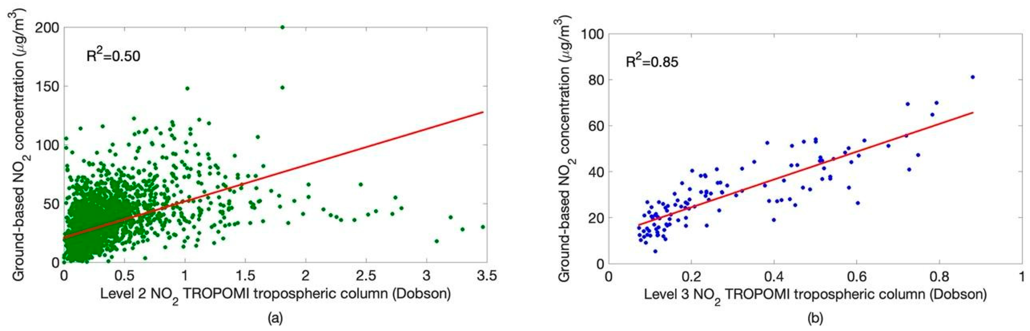
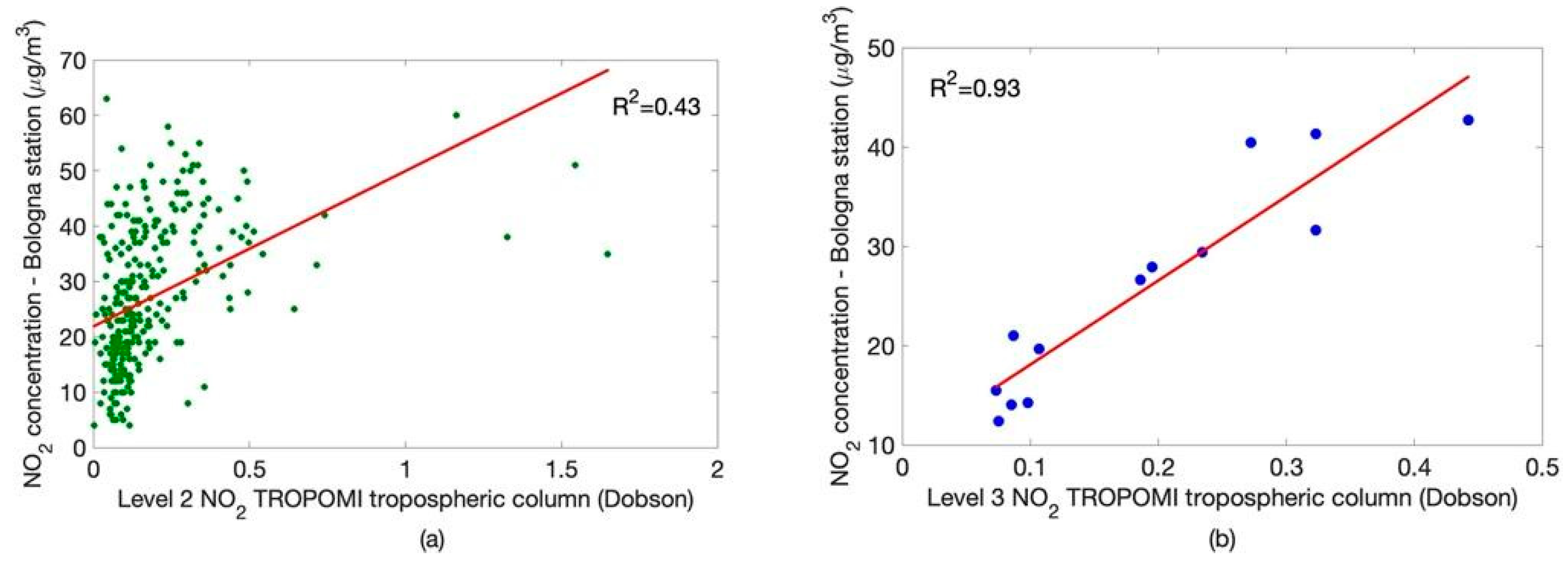
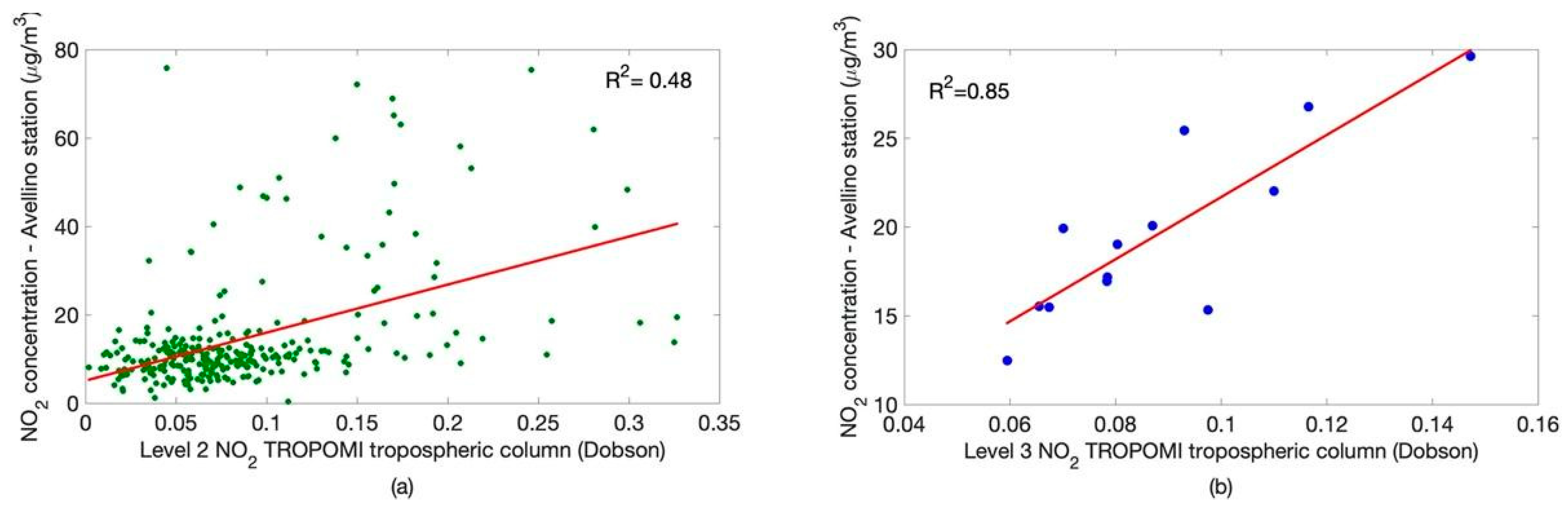
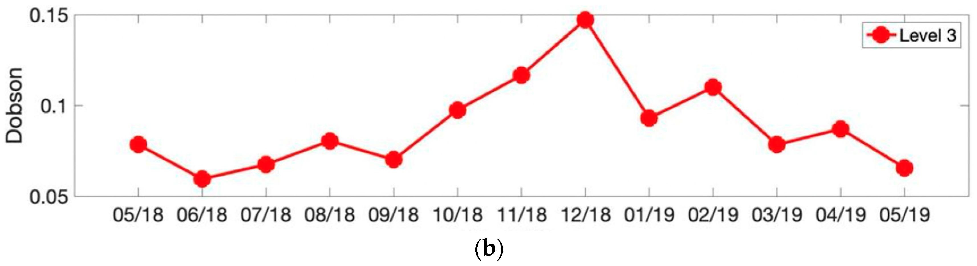
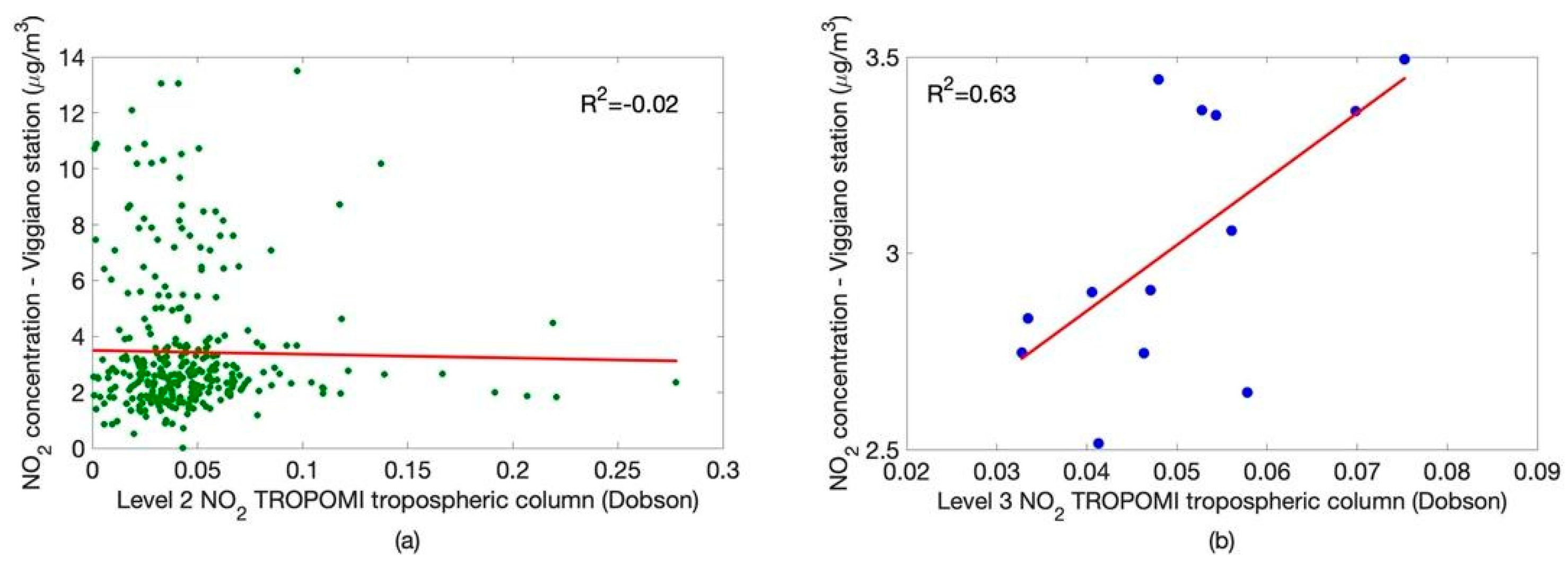
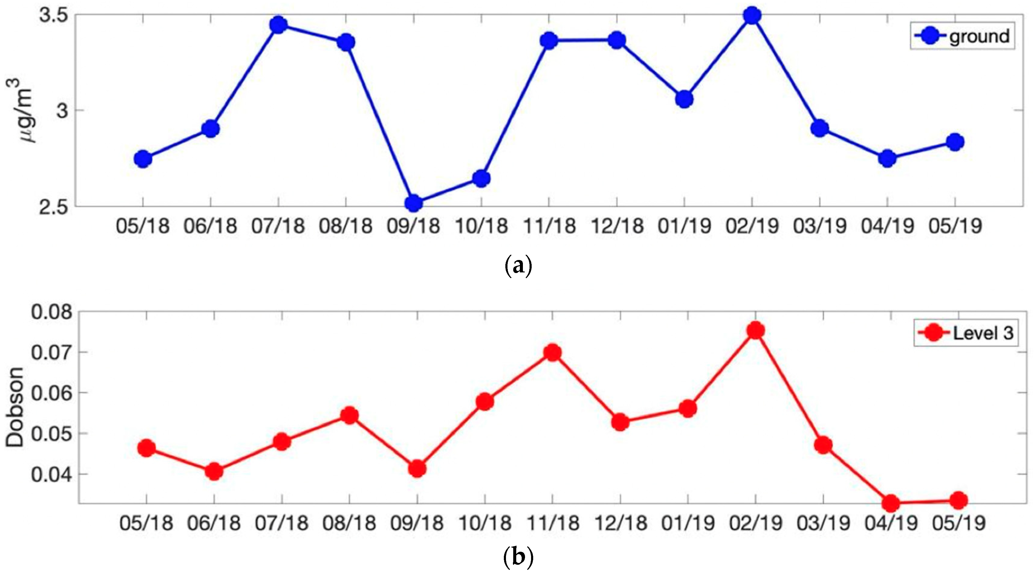
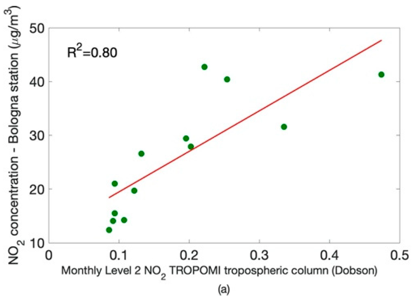
3.1. Comparing Satellite Data to in Situ Observations
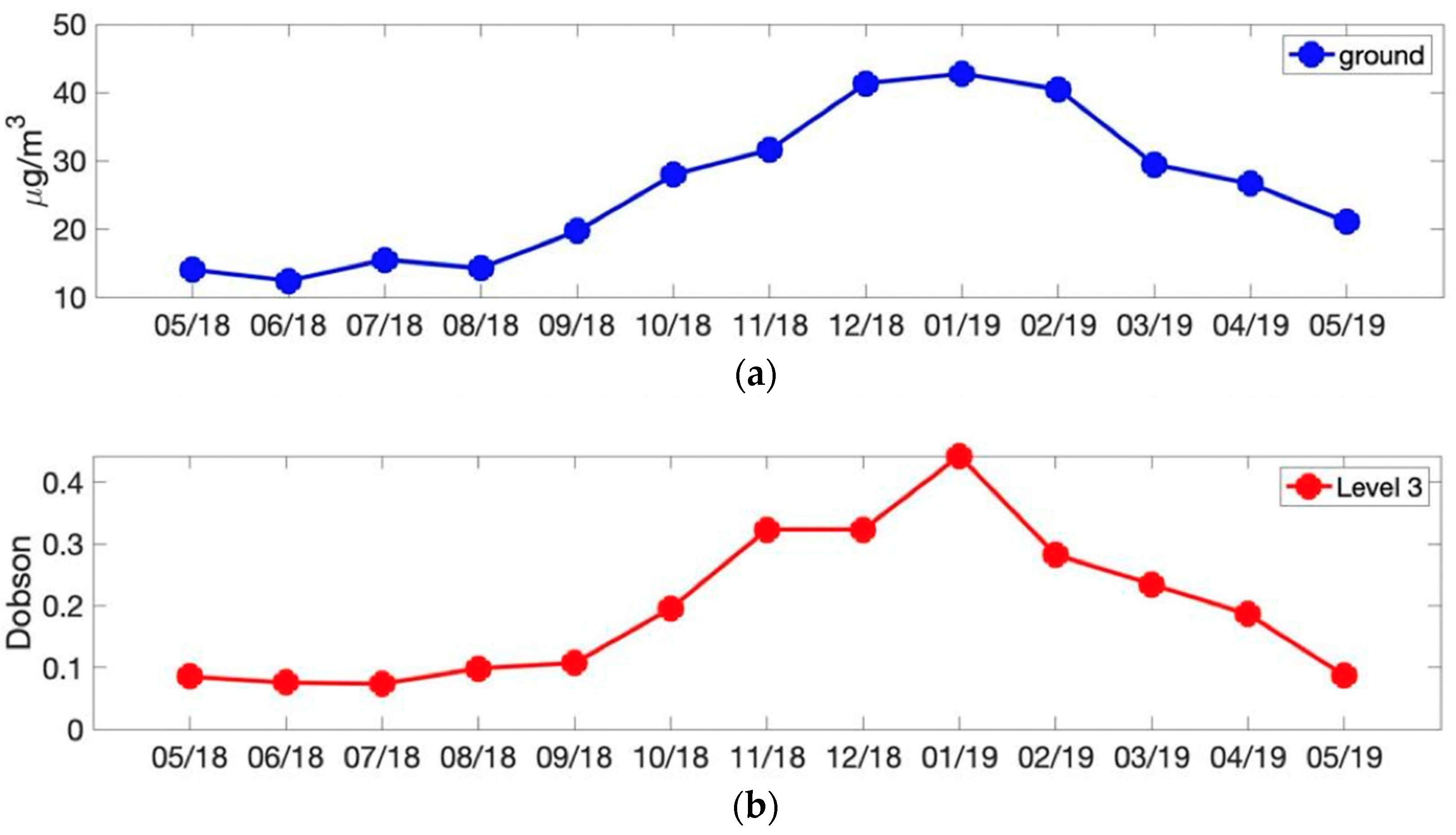
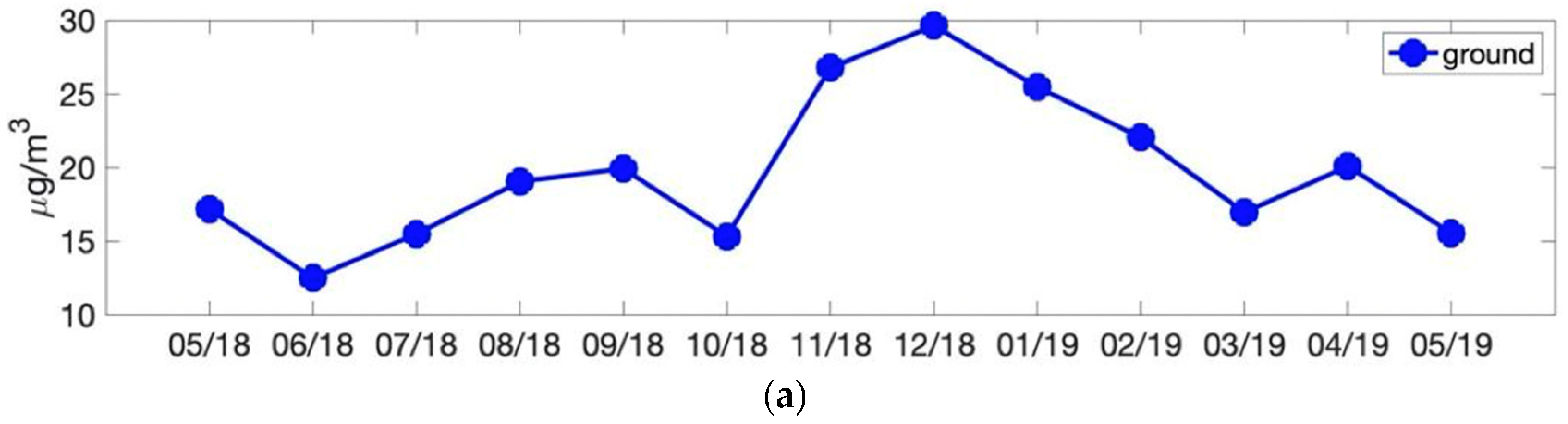
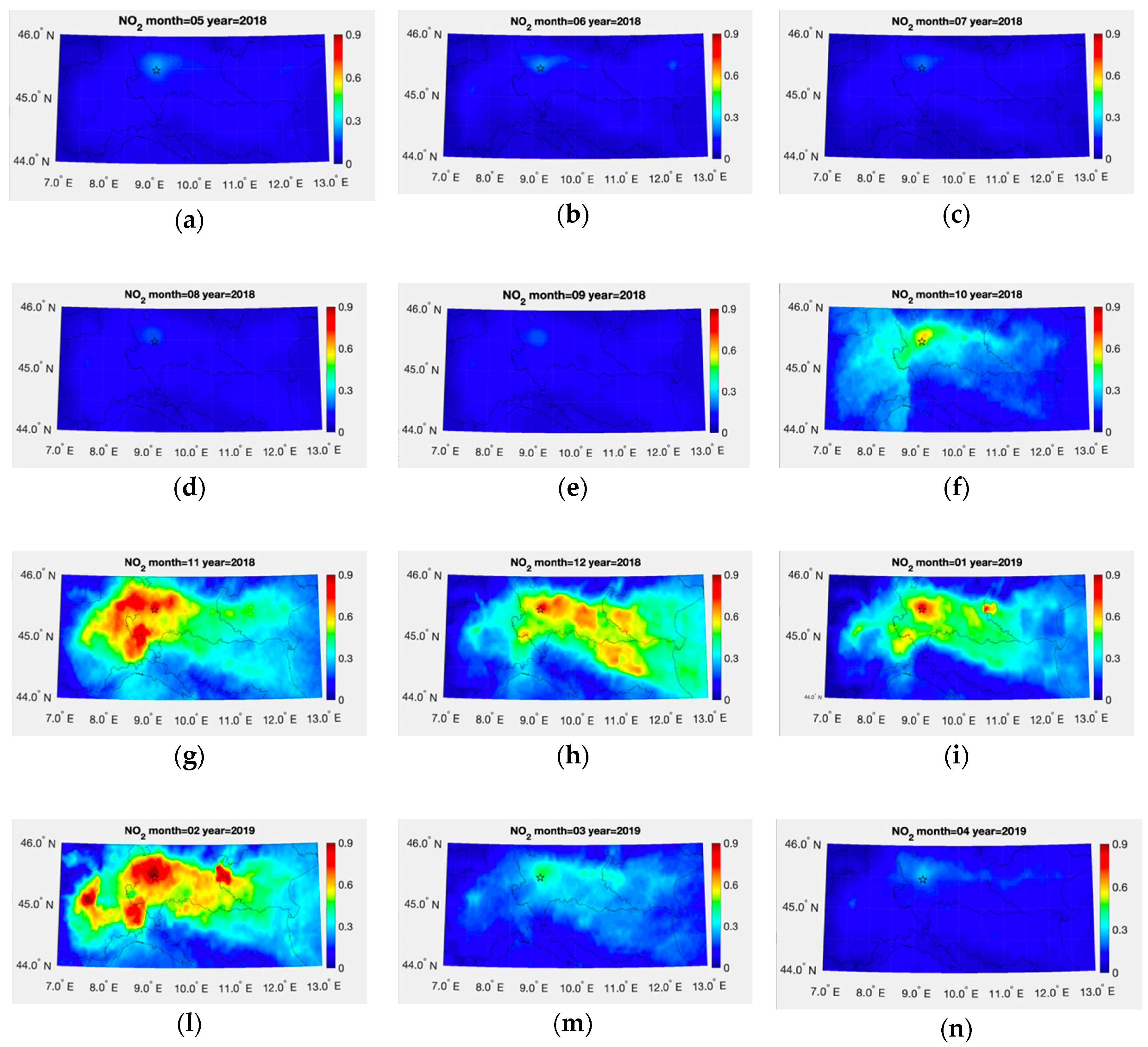
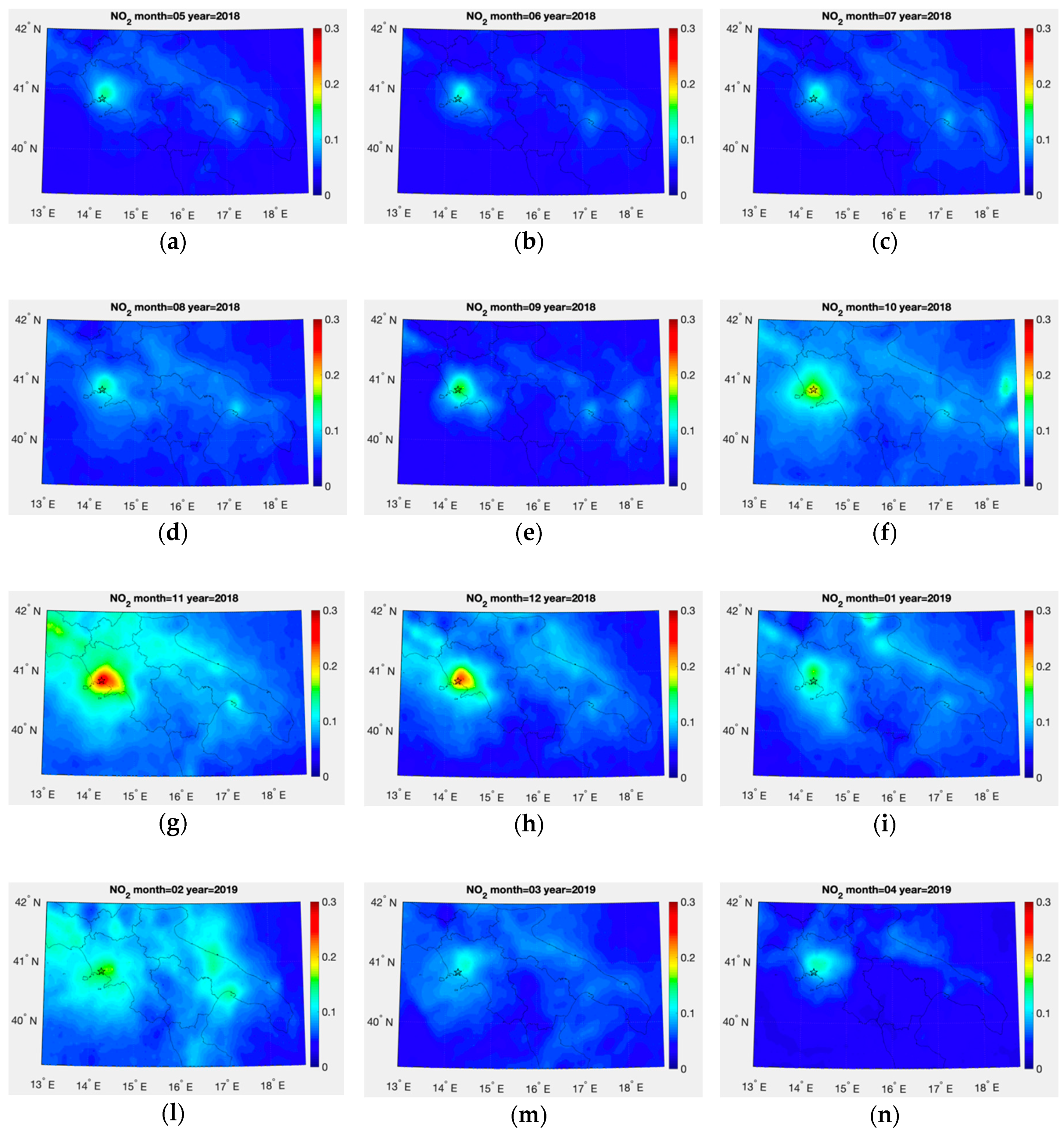
3.2. Monthly Spatial Map of Level 3 NO2 Tropospheric Column
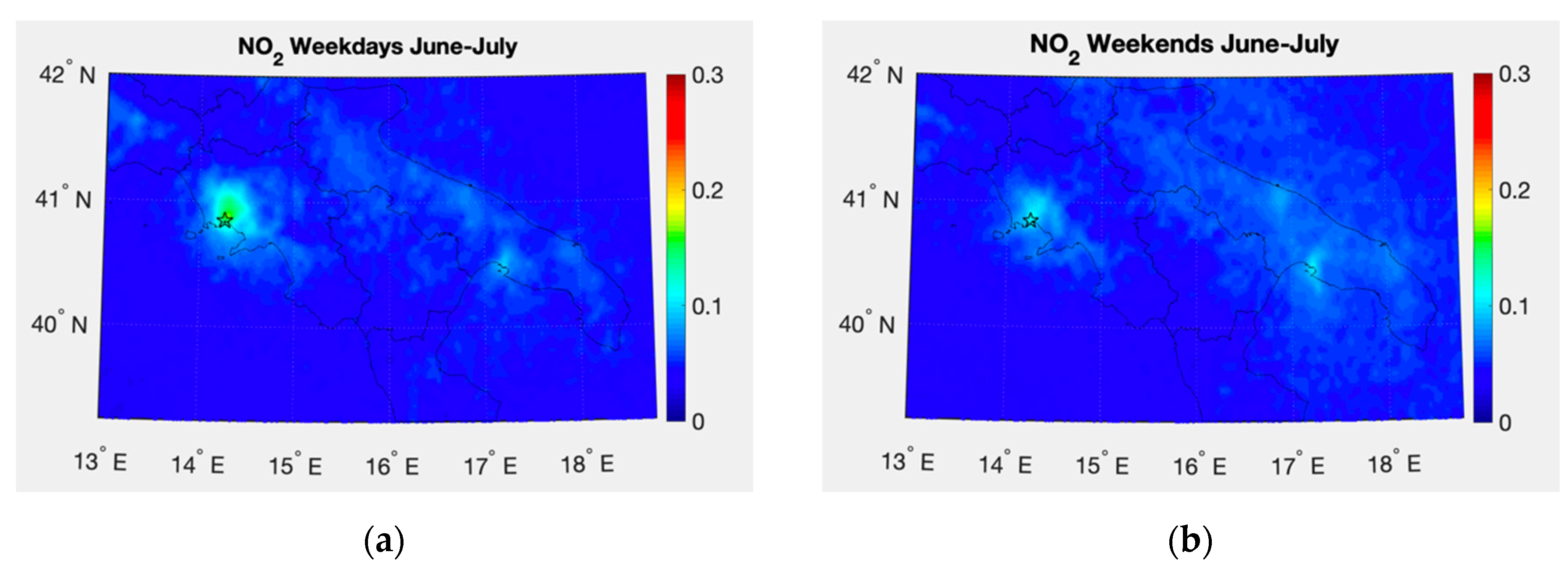
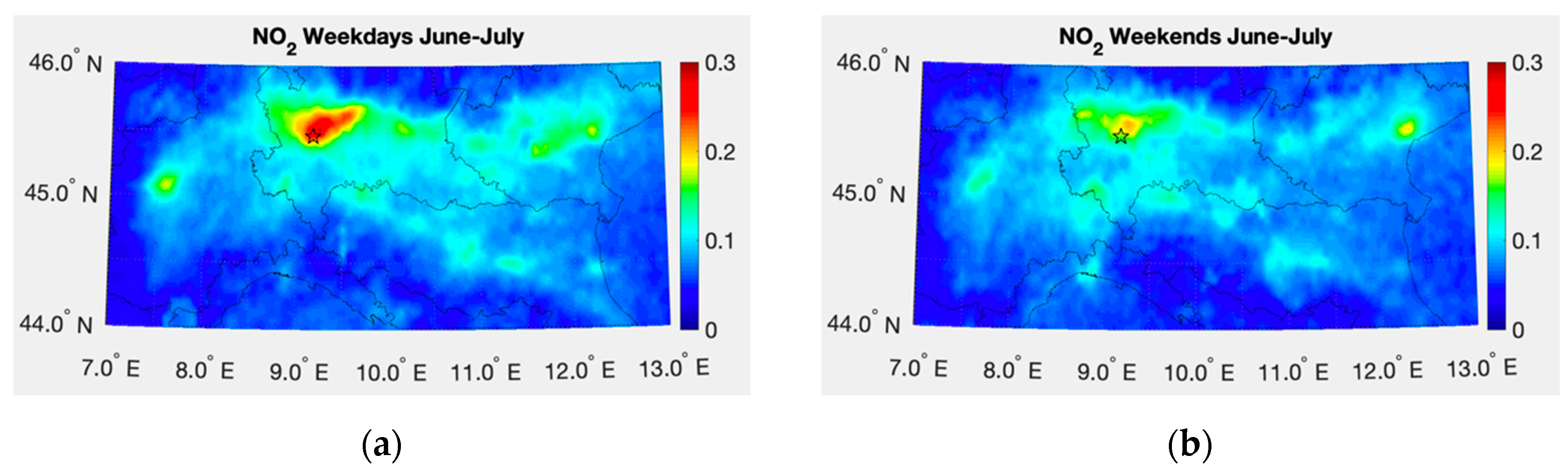
3.3. Weekdays and Weekend Observations
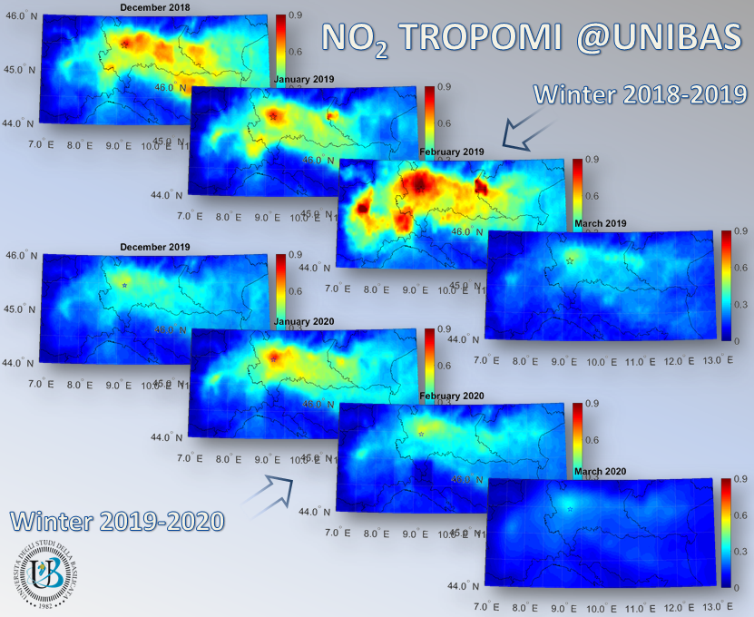
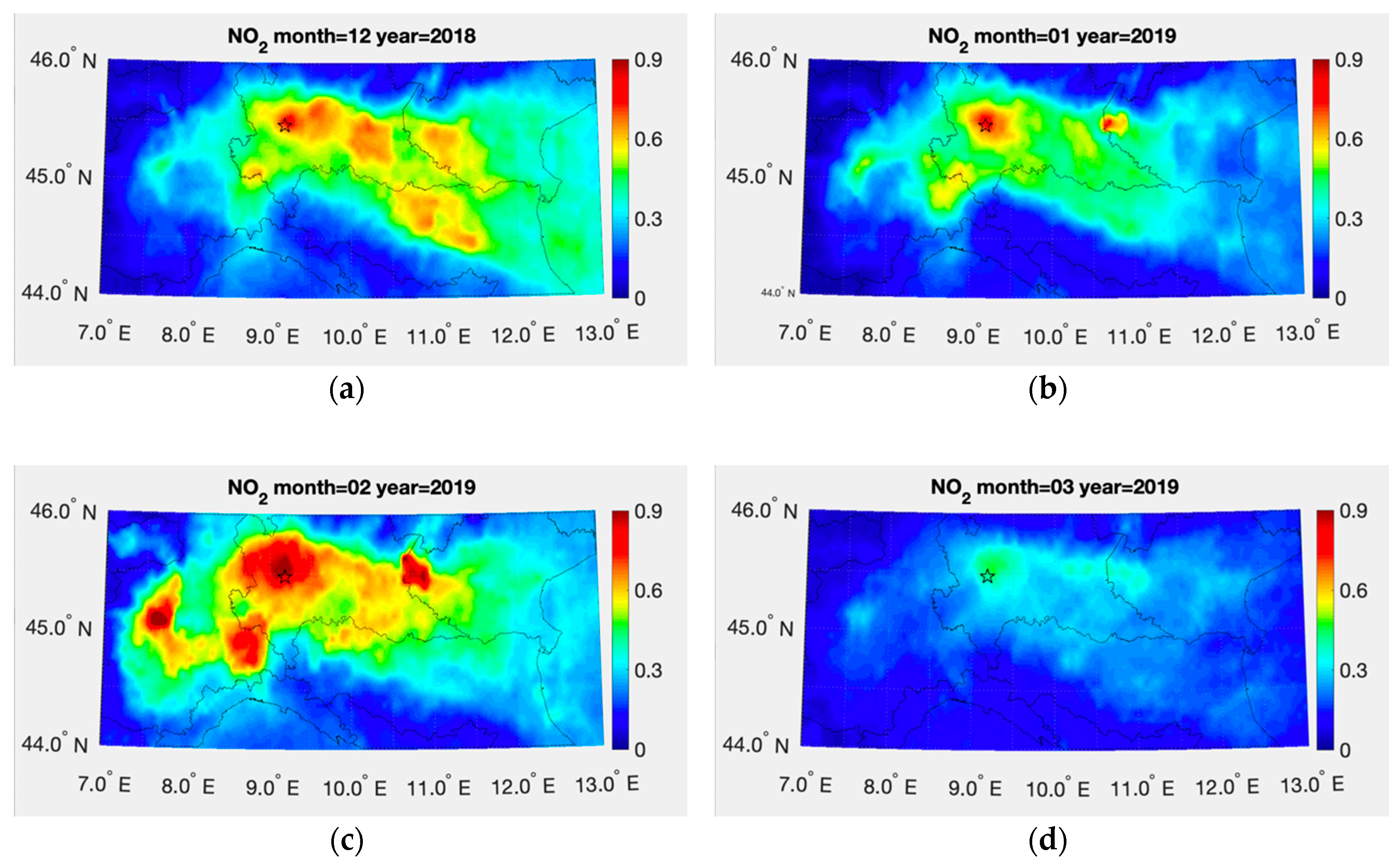
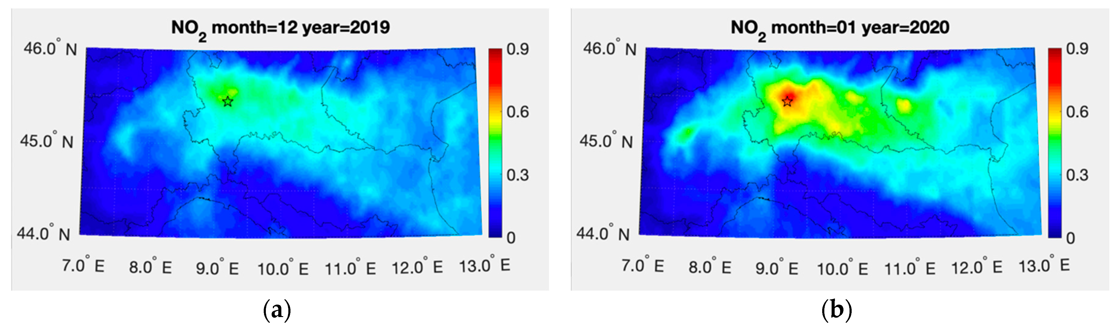
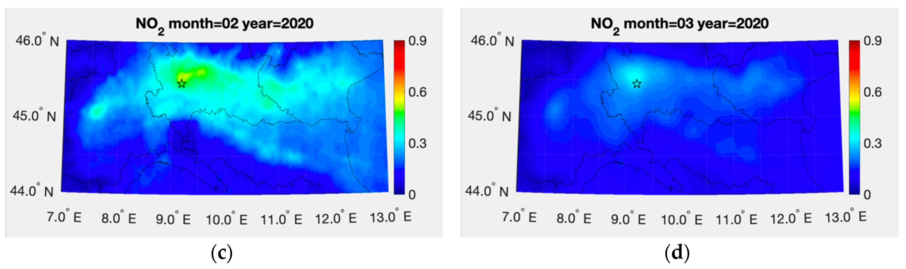
3.4. NO2 Pollution During COVID-19 Epidemic Crisis
4. Discussion
5. Conclusions
Author Contributions
Funding
Acknowledgments
Conflicts of Interest
References
- Van Geffen, J.H.G.M.; Eskes, H.J.; Boersma, K.F.; Maasakkers, J.D.; Veefkind, J.P. TROPOMI ATBD of the Total and Tropospheric NO2 Data Products; Royal Netherlands Meteorological Institute (KNMI): De Bilt, The Netherlands, 2019. [Google Scholar]
- World Health Organization. Health Aspects of Air Pollution with Particulate Matter, Ozone and Nitrogen Dioxide; World Health Organization: Bonn, Germany, 2003. [Google Scholar]
- Sillam, S.; Logan, J.A.; Wofsy, S.C. The sensitivity of ozone to nitrogen oxides and hydrocarbons in regional ozone episodes. J. Geophys. Res. 1990, 95, 1837–1851. [Google Scholar]
- Fuglestvedt, J.S.; Berntsen, T.; Isaksen, I.S.A.; Mao, H.; Liang, X.Z.; Wang, W.C. Climatic forcing of nitrogen oxides through changes in tropospheric ozone and methane. Atmos. Environ. 1999, 33, 961–977. [Google Scholar] [CrossRef]
- Shindell, D.T.; Faluvegi, G.; Koch, D.M.; Schmidt, G.A.; Unger, N.; Bauer, S.E. Improved attribution of climate forcing to emissions. Science 2009, 326, 716–718. [Google Scholar] [CrossRef] [PubMed]
- Seinfeld, J.H.; Pandis, S.N. Atmospheric Chemistry and Physics—From Air Pollution to Climate Change, 2nd ed.; John Wiley & Sons: New York, NY, USA, 2006. [Google Scholar]
- Hains, J.C.; Boersma, K.F.; Kroon, M.; Dirksen, R.J.; Cohen, R.C.; Perring, A.E.; Bucsela, E.; Volten, H.; Swart, D.P.J.; Richter, A.; et al. Testing and improving OMI DOMINO tropospheric NO2 using observations from the DANDELIONS and INTEX-B validation campaigns. J. Geophys. Res. 2010, 115, 20. [Google Scholar] [CrossRef]
- Masieri, S.; Bortoli, D.; Petritoli, A.; Kostadinov, I.; Premuda, M.; Ravegnani, F.; Carnevale, C.; Pisoni, E.; Volta, M.; Giovanelli, G. Tropospheric profile of NO2 over the Po Valley measured with scan DOAS spectrometer. In Proceedings of the SPIE 7478, Remote Sensing for Environmental Monitoring, GIS Applications, and Geology IX, 74782I, Berlin, Germany, 7 October 2009. [Google Scholar] [CrossRef]
- Piters, A.; Boersma, K.F.; Kroon, M.; Hains, J.C.; Roozendael, M.V.; Wittrock, F.; Abuhassan, N.; Adams, C.; Akrami, M.; Allaart, M.A.F.; et al. The Cabauw Intercomparison campaign for Nitrogen Dioxide measuring Instruments (CINDI): Design, execution, and early results. Atmos. Meas. Tech. 2012, 5, 457–485. [Google Scholar] [CrossRef]
- Lorente, A.; Boersma, K.F.; Yu, H.; Dörner, S.; Hilboll, A.; Richter, A.; Liu, M.; Lamsal, L.N.; Barkley, M.; De Smedt, I.; et al. Structural uncertainty in air mass factor calculation for NO2 and HCHO satellite retrievals. Atmos. Meas. Tech. 2017, 10, 759–782. [Google Scholar] [CrossRef]
- Tie, X.; Huang, R.J.; Cao, J.; Zhang, Q.; Cheng, Y.; Su, H.; Chang, D.; Pöschl, U.; Hoffmann, T.; Dusek, U.; et al. Severe Pollution in China Amplified by Atmospheric Moisture. Sci. Rep. 2017, 7, 15760. [Google Scholar] [CrossRef]
- Lamsal, L.N.; Janz, S.J.; Krotkov, N.A.; Pickering, K.E.; Spurr, R.J.D.; Kowalewski, M.G.; Loughner, C.P.; Crawford, J.H.; Swartz, W.H.; Herman, J.R. High-resolution NO2 observations from the Airborne Compact Atmospheric Mapper: Retrieval and validation. J. Geophys. Res. Atmos. 2017, 122, 1953–1970. [Google Scholar] [CrossRef]
- Su, T.; Li, Z.; Kahn, R. Relationships between the planetary boundary layer height and surface pollutants derived from lidar observations over China: Regional pattern and influencing factors. Atmos. Chem. Phys. 2018, 18, 15921–15935. [Google Scholar] [CrossRef]
- Schreier, S.F.; Richter, A.; Burrows, J.P. Near-surface and path-averaged mixing ratios of NO2 derived from car DOAS zenith-sky and tower DOAS off-axis measurements in Vienna: A case study. Atmos. Chem. Phys. 2019, 19, 5853–5879. [Google Scholar] [CrossRef]
- Berkhout, A.J.C.; Gast, L.F.L.; van der Hoff, G.R.; Swart, D.P.J.; Hoed, M.; Allaart, M. Atmospheric NO2 profiles measured with lidar during the CINDI-2 campaign. EPJ Web Conf. 2018, 176, 10002. [Google Scholar] [CrossRef][Green Version]
- Wang, Y.; Dörner, S.; Donner, S.; Böhnke, S.; De Smedt, I.; Dickerson, R.R.; Dong, Z.; He, H.; Li, Z.; Li, Z.; et al. Vertical profiles of NO2, SO2, HONO, HCHO, CHOCHO and aerosols derived from MAX-DOAS measurements at a rural site in the central western North China Plain and their relation to emission sources and effects of regional transport. Atmos. Chem. Phys. 2019, 19, 5417–5449. [Google Scholar] [CrossRef]
- Platt, U. Differential Optical Absorption Spectroscopy (DOAS). Air monitoring by spectroscopic techniques. Chem. Anal. 1994, 127, 27–76. [Google Scholar]
- Burrows, J.P.; Weber, M.; Buchwitz, M.; Rozanov, V.; Ladstätter-Weißenmayer, A.; Richter, A.; Debeek, R.; Hoogen, R.; Bramstedt, K.; Eichmann, K.U.; et al. The Global Ozone Monitoring Experiment (GOME): Mission concept and first results. J. Atmos. Sci. 1999, 56, 151–175. [Google Scholar] [CrossRef]
- Bovensmann, H.; Burrows, J.P.; Buchwitz, M.; Frerick, J.; Noel, S.; Rozanov, V.V.; Chance, K.V.; Goede, A.P.H. SCIAMACHY: Mission objectives and measurement modes. J. Atmos. Sci. 1999, 56, 127–150. [Google Scholar] [CrossRef]
- Levelt, P.F.; van den Oord, G.H.J.; Dobber, M.R.; Malkki, A.; Visser, H.; de Vries, J.; Stammes, P.; Lundell, J.O.V.; Saari, H. The Ozone Monitoring Instrument. IEEE Trans. Geosci. Remote Sens. 2006, 44, 1093–1101. [Google Scholar] [CrossRef]
- Munro, R.; Eisinger, M.; Anderson, C.; Callies, J.; Corpaccioli, E.; Lang, R.; Lefebvre, A.; Livschitz, Y.; Albinana, A.P. GOME-2 on MetOp. In Proceedings of the 2006 EUMETSAT Meteorological Satellite Conference, Helsinki, Finland, 12–16 June 2006. [Google Scholar]
- Veefkind, J.P.; Aben, I.; McMullan, K.; Förster, H.; De Vries, J.; Otter, G.; Claas, J.; Eskes, H.J.; De Haan, J.F.; Kleipool, Q.; et al. TROPOMI on the ESA Sentinel-5 Precursor: A GMES mission for global observations of the atmospheric composition for climate, air quality and ozone layer applications. Remote Sens. Environ. 2012, 120, 70–83. [Google Scholar] [CrossRef]
- Kim, H.C.; Lee, P.; Judd, L.; Pan, L.; Lefer, B. OMI NO2 column densities over North American urban cities: The effect of satellite footprint resolution. Geosci. Model Dev. 2016, 9, 1111–1123. [Google Scholar] [CrossRef]
- Lamsal, L.N.; Martin, R.V.; van Donkelaar, A.; Steinbacher, M.; Celarier, E.A.; Bucsela, E.; Dunlea, E.J.; Pinto, J.P. Ground-level nitrogen dioxide concentrations inferred from the satellite-borne Ozone Monitoring Instrument. J. Geophys. Res. 2008, 113, D16308. [Google Scholar] [CrossRef]
- Novotny, E.V.; Bechle, M.J.; Millet, D.B.; Marshall, J.D. National satellite-based land-use regression: NO2 in the United States. Environ. Sci. Technol. 2011, 45, 4407–4414. [Google Scholar] [CrossRef]
- Bechle, M.J.; Millet, D.B.; Marshall, J.D. National spatiotemporal exposure surface for NO2: Monthly scaling of a satellite-derived land-use regression. Environ. Sci. Technol. 2015, 49, 12297–12305. [Google Scholar] [CrossRef]
- Young, M.T.; Bechle, M.J.; Sampson, P.D.; Szpiro, A.A.; Marshall, J.D.; Sheppard, L.; Kaufman, J.D. Satellite-based NO2 and model validation in a national prediction model based on universal kriging and land-use regression. Environ. Sci. Technol. 2016, 50, 3686–3694. [Google Scholar] [CrossRef] [PubMed]
- Goldberg, D.L.; Lamsal, L.N.; Loughner, C.P.; Swartz, W.H.; Lu, Z.; Streets, D.G. A high-resolution and observationally constrained OMI NO2 satellite retrieval. Atmos. Chem. Phys. 2017, 17, 11403–11421. [Google Scholar] [CrossRef]
- Ialongo, I.; Virta, H.; Eskes, H.; Hovila, J.; Douros, J. Comparison of TROPOMI/Sentinel 5 Precursor NO2 observations with ground-based measurements in Helsinki. Atmos. Meas. Tech. 2020, 13, 205–218. [Google Scholar] [CrossRef]
- Boersma, K.F.; Jacob, D.J.; Trainic, M.; Rudich, Y.; DeSmedt, I.; Dirksen, R.; Eskes, H.J. Validation of urban NO2 concentrations and their diurnal and seasonal variations observed from the SCIAMACHY and OMI sensors using in situ surface measurements in Israeli cities. Atmos. Chem. Phys. 2009, 9, 3867–3879. [Google Scholar] [CrossRef]
- De Foy, B.; Lu, Z.; Streets, D.G. Impacts of control strategies, the Great Recession and weekday variations on NO2 columns above North American cities. Atmos. Environ. 2016, 138, 74–86. [Google Scholar] [CrossRef]
- KNMI. Algorithm Theoretical Basis Document for the TROPOMI L01b Data Processor; KNMI: De Bilt, The Netherlands, 2017. [Google Scholar]
- Griffin, D.; Zhao, X.; McLinden, C.A.; Boersma, F.; Bourassa, A.; Dammers, E.; Degenstein, D.; Eskes, H.; Fehr, L.; Fioletov, V.; et al. High-resolution mapping of nitrogen dioxide with TROPOMI: First results and validation over the Canadian oil sands. Geophs. Res. Lett. 2019, 46, 1049–1060. [Google Scholar] [CrossRef]
- Boersma, K.F.; Eskes, H.J.; Brinksma, E.J. Error analysis for tropospheric NO2 retrieval from space. J. Geophys. Res. 2004, 109, DO4311. [Google Scholar] [CrossRef]
- Boersma, K.F.; Eskes, H.J.; Dirksen, R.J.; Van Der, A.R.J.; Veefkind, J.P.; Stammes, P.; Huijnen, V.; Kleipool, Q.L.; Sneep, M.; Claas, J.; et al. An improved tropospheric NO2 column retrieval algorithm for the Ozone Monitoring Instrument. Atmos. Meas. Tech. 2011, 4, 1905–1928. [Google Scholar] [CrossRef]
- Platt, U.; Stutz, J. Differential Optical Absorption Spectroscopy: Principles and Applications; Springer: Berlin, Germany, 2008. [Google Scholar] [CrossRef]
- Williams, A.P.; Cook, B.I.; Smerdon, J.E.; Bishop, D.A.; Seager, R.; Mankin, J.S. The 2016 southeastern U.S. drought: An extreme departure from centennial wetting and cooling. J. Geophys. Res. Atmos. 2017, 122, 10888–10905. [Google Scholar] [CrossRef]
- CREODIAS Platform. Available online: https://creodias.eu (accessed on 20 May 2020).
- ARPA Basilicata. Available online: http://www.arpab.it (accessed on 20 May 2020).
- ARPA Campania. Available online: https://www.arpacampania.it (accessed on 20 May 2020).
- ARPA Puglia. Available online: http://www.arpa.puglia.it (accessed on 20 May 2020).
- ARPA Lombardia. Available online: https://www.arpalombardia.it (accessed on 20 May 2020).
- ARPA Emilia-Romagna. Available online: https://www.arpae.it (accessed on 20 May 2020).
- Koner, P.K.; Harris, A.R.; Dash, P. A deterministic method for profiles retrievals from hyperspectral satellite measurements. IEEE Trans. Geosci. Remote Sens. 2016, 54, 5657–5670. [Google Scholar] [CrossRef]
- Koner, P.K.; Dash, P. Maximizing the information content of ill-posed space-based measurements using Deterministic Inverse Method. Remote Sens. 2018, 10, 994. [Google Scholar] [CrossRef] [PubMed]
- Cressie, N.A.C. Statistics for Spatial Data, revised ed.; Wiley-Interscience Publication: New York, NY, USA, 2015. [Google Scholar]
- Wackernagel, H. Multivariate Geostatistics. An Introduction with Applications; Springer: Berlin, Germany, 2003. [Google Scholar]
- Cersosimo, A.; Larosa, S.; Romano, F.; Cimini, D.; Di Paola, F.; Gallucci, D.; Gentile, S.; Geraldi, E.; Nilo, S.T.; Ricciardelli, E.; et al. Downscaling of Satellite OPEMW Surface Rain Intensity Data. Remote Sens. 2018, 10, 1763. [Google Scholar] [CrossRef]
- Wikle, C.K.; Berliner, L.M. A Bayesian Tutorial for data assimilation. Phys. D Nonlinear Phenom. 2007, 230, 1–26. [Google Scholar] [CrossRef]
- Masiello, G.; Serio, C.; De Feis, I.; Amoroso, M.; Venafra, S.; Trigo, I.F.; Watts, P. Kalman filter physical retrieval of surface emissivity and temperature from geostationary infrared radiances. Atmos. Meas. Tech. 2013, 6, 3613–3634. [Google Scholar] [CrossRef]
- Masiello, G.; Serio, C.; Venafra, S.; Liuzzi, G.; Göttsche, F.; Trigo, I.F.; Watts, P. Kalman filter physical retrieval of surface emissivity and temperature from SEVIRI infrared channels: A validation and intercomparison study. Atmos. Meas. Tech. 2015, 8, 2981–2997. [Google Scholar] [CrossRef]
- De Feis, I.; Masiello, G.; Cersosimo, A. Optimal Interpolation for Infrared Products from Hyperspectral Satellite Imagers and Sounders. Sensors 2020, 20, 2352. [Google Scholar] [CrossRef]
- Gu, J.; Chen, L.; Yu, C.; Li, S.; Tao, J.; Fan, M.; Xiong, X.; Wang, Z.; Shang, H.; Su, L. Ground-Level NO2 Concentrations over China Inferred from the Satellite OMI and CMAQ Model Simulations. Remote Sens. 2017, 9, 519. [Google Scholar] [CrossRef]
- Chilès, J.P.; Delfiner, P. Geostatistics: Modeling Spatial Uncertainty, 2nd ed.; Wiley: New York, NY, USA, 2012. [Google Scholar]
- Schabenberger, O.; Gotway, C.A. Statistical Methods for Spatial Data Analysis; Chapman & Hall/CRC Press: Boca Raton, FL, USA, 2005; p. 488. ISBN 1-58488-322-7. [Google Scholar]
- Cressie, N.; Gardar, J. Fixed Rank Kriging for Very Large Spatial Data Sets. J. R. Stat. Soc. Ser. B Stat. Methodol. 2008, 70, 209–226. Available online: www.jstor.org/stable/20203819 (accessed on 23 June 2020). [CrossRef]
- Chen, T.H.; Hsu, Y.C.; Zeng, Y.T.; Lung, S.C.C.; Su, H.J.; Chao, H.J.; Wu, C.D. A hybrid kriging/land-use regression model with Asian culture-specific sources to assess NO2 spatial-temporal variations. Environ. Pollut. 2020, 259, 113875. [Google Scholar] [CrossRef]
- Van Zoest, V.; Osei, F.B.; Hoek, G.; Stein, A. Spatiotemporal regression kriging for modelling urban NO2 concentrations. Int. J. Geogr. Inf. Sci. 2020, 34, 851–865. [Google Scholar] [CrossRef]


| Ground Station | Longitude | Latitude | a | b | e | R2 |
|---|---|---|---|---|---|---|
| BOLOGNA-DE AMICIS | 11.72 | 44.36 | 84.67 | 9.61 | 3.75 | 0.93 |
| BRESCIA | 10.22 | 45.54 | 42.13 | 18.34 | 4.25 | 0.88 |
| CITTADELLA | 10.33 | 44.79 | 48.63 | 8.37 | 4.81 | 0.85 |
| GIORDANI-FARNESE | 9.69 | 45.05 | 57.61 | 16.80 | 5.08 | 0.89 |
| MANTOVA | 10.79 | 45.16 | 59.71 | 7.74 | 8.42 | 0.76 |
| MILANO | 9.20 | 45.46 | 42.11 | 25.05 | 7.24 | 0.80 |
| PAVIA | 9.15 | 45.18 | 55.83 | 10.95 | 7.68 | 0.83 |
| SAN ROCCO | 10.66 | 44.87 | 36.05 | 7.28 | 4.03 | 0.83 |
| SESTO S. GIOVANNI | 9.25 | 45.53 | 55.69 | 18.37 | 9.42 | 0.83 |
| VIGEVANO | 8.85 | 45.32 | 44.69 | 8.34 | 5.85 | 0.84 |
| Ground Station | Longitude | Latitude | a | b | e | R2 |
|---|---|---|---|---|---|---|
| ACERRA SCUOLA CAPORALE | 14.37 | 40.94 | 248.78 | −7.41 | 8.65 | 0.64 |
| ALTAMURA | 16.56 | 40.83 | 322.97 | −0.69 | 4.16 | 0.75 |
| ANDRIA | 16.30 | 41.23 | 329.19 | −3.15 | 3.33 | 0.84 |
| AVELLINO | 14.78 | 40.92 | 175.17 | 4.17 | 2.57 | 0.85 |
| BARI-CALDAROLA | 16.88 | 41.11 | 450.14 | 3.15 | 4.60 | 0.79 |
| BARI-CARBONARA | 16.86 | 41.07 | 302.81 | −8.49 | 2.87 | 0.78 |
| BARI-CAVOUR | 16.87 | 41.12 | 229.15 | 17.51 | 3.17 | 0.70 |
| BARI-CUS | 16.84 | 41.13 | 236.72 | −2.81 | 3.36 | 0.68 |
| BARI-VIA KENNEDY | 16.86 | 41.09 | 309.28 | −0.73 | 2.16 | 0.87 |
| BARLETTA | 16.28 | 41.31 | 267.84 | −3.97 | 2.97 | 0.83 |
| BENEVENTO | 14.78 | 41.11 | 716.20 | −35.83 | 4.12 | 0.90 |
| BRINDISI-VIA CRATI | 17.95 | 40.63 | 226.60 | 1.32 | 1.26 | 0.74 |
| CAMPI SALENTINA | 18.03 | 40.40 | 321.67 | −10.66 | 2.34 | 0.59 |
| FOGGIA-VIA ROSATI | 15.55 | 41.45 | 292.48 | −4.51 | 4.50 | 0.68 |
| FRANCAVILLA | 17.58 | 40.53 | 337.60 | −7.88 | 5.29 | 0.59 |
| GROTTAGLIE | 17.42 | 40.54 | 179.05 | −4.62 | 2.49 | 0.61 |
| LECCE-VIA GARIGLIANO | 18.17 | 40.36 | 627.30 | −24.79 | 4.00 | 0.55 |
| MADDALONI | 14.37 | 41.04 | 156.80 | 2.63 | 3.42 | 0.72 |
| MANFREDONIA | 15.91 | 41.63 | 174.43 | 8.44 | 1.59 | 0.90 |
| MESAGNE | 17.81 | 40.56 | 259.81 | −7.18 | 1.71 | 0.74 |
| MODUGNO-ENO2 | 16.77 | 41.14 | 249.02 | 1.21 | 1.92 | 0.87 |
| MODUGNO-ENO3 | 16.78 | 41.09 | 169.26 | 8.88 | 1.36 | 0.83 |
| MODUGNO-ENO4 | 16.79 | 41.11 | 465.30 | −11.35 | 3.47 | 0.86 |
| MOLFETTA-VERDI | 16.60 | 41.20 | 297.01 | −0.73 | 2.54 | 0.89 |
| MONOPOLI-ALDO MORO | 17.29 | 40.95 | 461.40 | −9.14 | 3.97 | 0.81 |
| MONOPOLI-ITALGREEN | 17.28 | 40.96 | 233.88 | −2.77 | 1.53 | 0.88 |
| MONTE S. ANGELO | 15.94 | 41.66 | 85.03 | 1.53 | 1.65 | 0.68 |
| NAPOLI PARCO VIRGILIANO | 14.18 | 40.79 | 64.97 | 3.87 | 2.34 | 0.67 |
| NOCERA INFERIORE | 14.64 | 40.74 | 267.29 | −4.12 | 10.24 | 0.52 |
| PORTICI | 14.34 | 40.81 | 69.06 | 9.11 | 3.57 | 0.76 |
| SALERNO | 14.77 | 40.69 | 204.27 | 27.50 | 7.00 | 0.60 |
| S. PANCRAZIO SALENTINO | 17.84 | 40.42 | 164.45 | −3.11 | 2.25 | 0.54 |
| SAN SEVERO | 15.38 | 41.69 | 186.92 | −2.46 | 2.43 | 0.80 |
| SURBO | 18.12 | 40.41 | 257.69 | −5.14 | 1.82 | 0.55 |
| TORRE ANNUNZIATA | 14.43 | 40.76 | 77.32 | 11.18 | 3.14 | 0.76 |
| VIGGIANO-COSTA MOLINA | 15.95 | 40.32 | 16.80 | 2.18 | 0.25 | 0.63 |
| VIGGIANO 1 | 15.90 | 40.33 | 85.07 | −0.71 | 1.03 | 0.71 |
| Bergamo | Brescia | Milano | ||||
|---|---|---|---|---|---|---|
| Month | Satellite | In Situ | Satellite | In Situ | Satellite | In Situ |
| December | −39.3% | −37.4% | −30.5% | −16.0% | −29.4% | −25.6% |
| January | −9.4% | −14.2% | −10.6% | −9.0% | −5.0% | −26.08% |
| February | −28.1% | −44.4% | −33.3% | −23.9% | −39.2% | −18.47% |
| March | −25.8% | −49.2% | −44.7% | −41.12% | −21% | −33.85% |
| April | −20.0% | −30.1% | −15.8% | −51.8% | −16.7% | −40.0% |
© 2020 by the authors. Licensee MDPI, Basel, Switzerland. This article is an open access article distributed under the terms and conditions of the Creative Commons Attribution (CC BY) license (http://creativecommons.org/licenses/by/4.0/).
Share and Cite
Cersosimo, A.; Serio, C.; Masiello, G. TROPOMI NO2 Tropospheric Column Data: Regridding to 1 km Grid-Resolution and Assessment of their Consistency with In Situ Surface Observations. Remote Sens. 2020, 12, 2212. https://doi.org/10.3390/rs12142212
Cersosimo A, Serio C, Masiello G. TROPOMI NO2 Tropospheric Column Data: Regridding to 1 km Grid-Resolution and Assessment of their Consistency with In Situ Surface Observations. Remote Sensing. 2020; 12(14):2212. https://doi.org/10.3390/rs12142212
Chicago/Turabian StyleCersosimo, Angela, Carmine Serio, and Guido Masiello. 2020. "TROPOMI NO2 Tropospheric Column Data: Regridding to 1 km Grid-Resolution and Assessment of their Consistency with In Situ Surface Observations" Remote Sensing 12, no. 14: 2212. https://doi.org/10.3390/rs12142212
APA StyleCersosimo, A., Serio, C., & Masiello, G. (2020). TROPOMI NO2 Tropospheric Column Data: Regridding to 1 km Grid-Resolution and Assessment of their Consistency with In Situ Surface Observations. Remote Sensing, 12(14), 2212. https://doi.org/10.3390/rs12142212