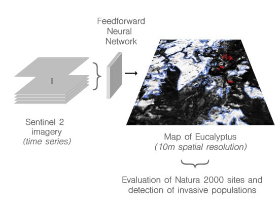
Mapping of Eucalyptus in Natura 2000 Areas Using Sentinel 2 Imagery and Artificial Neural Networks
Abstract
1. Introduction
2. Data and Method
2.1. Study Sites
2.2. Satellite Imagery
2.3. Data Analysis
2.4. Algorithm Performance and Validation
2.5. Uncertainty Assessment
2.6. Qualitative Assessment
2.7. Quantitative Assessment and Comparison to Other Data-Sets
3. Results
3.1. Model Performance
3.2. Predictions
4. Discussion
5. Conclusions
Author Contributions
Funding
Acknowledgments
Conflicts of Interest
Appendix A
| Reference | ||||||
|---|---|---|---|---|---|---|
| Eucalyptus | Non-Eucalyptus | Total | User’s Accuracy | Producer’s Accuracy | ||
| Model | Eucalyptus | 105,323 | 24,052 | 129,375 | 0.814 | 0.757 |
| Non-Eucalyptus | 33,744 | 546,950 | 580,694 | 0.942 | 0.958 | |
| Total | 139,067 | 571,002 | 710,069 | |||
| Reference | ||||||
|---|---|---|---|---|---|---|
| Eucalyptus | Non-Eucalyptus | Total | User’s Accuracy | Producer’s Accuracy | ||
| Model | Eucalyptus | 21,013 | 17,269 | 38,282 | 0.549 | 0.623 |
| Non-Eucalyptus | 12,697 | 1,169,326 | 1,182,023 | 0.989 | 0.985 | |
| Total | 33,710 | 1,186,595 | 1,220,305 | |||
| Reference | ||||||
|---|---|---|---|---|---|---|
| Eucalyptus | Non-Eucalyptus | Total | User’s Accuracy | Producer’s Accuracy | ||
| Model | Eucalyptus | 152,242 | 22,464 | 174,706 | 0.871 | 0.629 |
| Non-Eucalyptus | 89,787 | 472,182 | 561,969 | 0.840 | 0.955 | |
| Total | 242,029 | 494,646 | 736,675 | |||
| Natura 2000 Name | Site Code | State |
|---|---|---|
| Alvão / Marão | PTCON0003 | not affected/only slightly |
| Alvito/Cuba | PTCON0035 | not affected/only slightly |
| Arade / Odelouca | PTCON0052 | not affected/only slightly |
| Arrábida / Espichel | PTCON0010 | not affected/only slightly |
| Barrocal | PTCON0049 | not affected/only slightly |
| Cabeção | PTCON0029 | not affected/only slightly |
| Cabrela | PTCON0033 | not affected/only slightly |
| Caia | PTCON0030 | not affected/only slightly |
| Caldeirão | PTCON0057 | not affected/only slightly |
| Cambarinho | PTCON0016 | not affected/only slightly |
| Carregal do Sal | PTCON0027 | not affected/only slightly |
| Castro Verde | PTZPE0046 | not affected/only slightly |
| Complexo do Açor | PTCON0051 | not affected/only slightly |
| Comporta / Galé | PTCON0034 | not affected/only slightly |
| Côrno do Bico | PTCON0040 | not affected/only slightly |
| Douro Internacional e Vale do Águeda | PTZPE0038 | not affected/only slightly |
| Dunas de Mira, Gândara e Gafanhas | PTCON0055 | not affected/only slightly |
| Estuário do Sado | PTCON0011 | not affected/only slightly |
| Estuário do Tejo | PTCON0009 | not affected/only slightly |
| Évora | PTZPE0055 | not affected/only slightly |
| Fernão Ferro / Lagoa de Albufeira | PTCON0054 | not affected/only slightly |
| Gardunha | PTCON0028 | not affected/only slightly |
| Peneda / Gerês | PTCON0001 | not affected/only slightly |
| Guadiana | PTCON0036 | not affected/only slightly |
| Litoral Norte | PTCON0017 | not affected/only slightly |
| Minas de St. Adrião | PTCON0042 | not affected/only slightly |
| Monforte | PTZPE0051 | not affected/only slightly |
| Monfurado | PTCON0031 | not affected/only slightly |
| Montesinho / Nogueira | PTZPE0003 | not affected/only slightly |
| Morais | PTCON0023 | not affected/only slightly |
| Moura / Barrancos | PTCON0053 | not affected/only slightly |
| Nisa / Lage da Prata | PTCON0044 | not affected/only slightly |
| Paul do Taipal | PTZPE0040 | not affected/only slightly |
| Peniche / Sta Cruz | PTCON0056 | not affected/only slightly |
| Piçarras | PTZPE0058 | not affected/only slightly |
| Reguengos | PTZPE0056 | not affected/only slightly |
| Ria de Aveiro | PTCON0061 | not affected/only slightly |
| Ria Formosa / Castro Marim | PTCON0013 | not affected/only slightly |
| Rio Lima | PTCON0020 | not affected/only slightly |
| Rio Minho | PTCON0019 | not affected/only slightly |
| Rios Sabor e Maçãs | PTZPE0037 | not affected/only slightly |
| Romeu | PTCON0043 | not affected/only slightly |
| Serra D’Arga | PTCON0039 | not affected/only slightly |
| Serra da Estrela | PTCON0014 | not affected/only slightly |
| Serra de Montejunto | PTCON0048 | not affected/only slightly |
| Serras d’Aire e Candeeiros | PTCON0015 | not affected/only slightly |
| Sintra / Cascais | PTCON0008 | not affected/only slightly |
| Tejo Internacional, Erges e Pônsul | PTZPE0042 | not affected/only slightly |
| Vale do Côa | PTZPE0039 | not affected/only slightly |
| Vale do Guadiana | PTZPE0047 | not affected/only slightly |
| Veiros | PTZPE0052 | not affected/only slightly |
| Vila Fernando | PTZPE0053 | not affected/only slightly |
References
- Luzar, J. The Political Ecology of a “Forest Transition”: Eucalyptus Forestry in the Southern Peruvian. Ethnobot. Res. Appl. 2007, 5, 85–93. [Google Scholar] [CrossRef]
- Kardell, L.; Steen, E.; Fabião, A. Eucalyptus in Portugal—A threat or a promise. Ambio J. Hum. Environ. 1986, XV, 6–13. [Google Scholar]
- Doughty, R.W. The Eucalyptus: A Natural and Commercial History of the Gum Tree; Johns Hopkins University Press: Baltimore, MD, USA, 2000. [Google Scholar]
- Graça, M.A.; Pozo, J.; Canhoto, C.; Elosegi, A. Effects of Eucalyptus Plantations on Detritus, Decomposers, and Detritivores in Streams. Sci. World J. 2002, 2. [Google Scholar] [CrossRef] [PubMed]
- Becerra, P.I.; Catford, J.A.; Luce McLeod, M.; Andonian, K.; Aschehoug, E.T.; Montesinos, D.; Callaway, R.M. Inhibitory effects of Eucalyptus globulus on understorey plant growth and species richness are greater in non-native regions. Glob. Ecol. Biogeogr. 2018, 27, 68–76. [Google Scholar] [CrossRef]
- Ferreira, V.; Elosegi, A.; Gulis, V.; Pozo, J.; Graça, M.A.S. Eucalyptus plantations affect fungal communities associated with leaf-litter decomposition in Iberian streams. Arch. Hydrobiol. 2006, 166, 467–490. [Google Scholar] [CrossRef]
- Decreto-Lei nr 92/2019. Presidência do Conselho de Ministros Ambiente e Transição Energética-Diário da República-1a Série, Nr. 130/2019, 2019, pp. 3428–3442. Available online: https://dre.pt/home/-/dre/122289404/details/maximized (accessed on 30 April 2020).
- Marchante, H.; Morais, M.; Freitas, H.; Marchante, E. Guia Prático Para a Identificação de Plantas Invasoras em Portugal; Coimbra University Press: Coimbra, Portugal, 2014. [Google Scholar]
- European Commission (EC). Towards an EU Strategy on Invasive Species COM(2008) 789 Final; Official Journal of the European Union, Publications Office of the European Union: Luxembourg, 2008. [Google Scholar]
- Hulme, P.E.; Pyšek, P.; Nentwig, W.; Vilà, M. Will Threat of Biological Invasions Unite the European Union? Science 2009, 324, 40–41. [Google Scholar] [CrossRef]
- Council of the European Communities. COUNCIL DIRECTIVE 92/43/EEC of 21 May 1992 on the conservation of natural habitats and of wild fauna and flora. In Official Journal of the European Communities; Council of the European Communities, Publications Office of the European Union: Luxembourg, 1992; pp. 7–51. [Google Scholar]
- Council of the European Union. Directive 2009/147/EC of the European Parliament and of the Council of 30 November 2009 on the conservation of wild birds. In Official Journal of the European Union; Council of the European Union, Publications Office of the European Union: Luxembourg, 2009; pp. 7–25. [Google Scholar]
- Guth, J.; Kučera, T. Natura 2000 habitat mapping in the Czech Republic: Methods and general results. Ekológia (Bratislava) 2005, 24, 39–51. [Google Scholar]
- Delaney, D.G.; Sperling, C.D.; Adams, C.S.; Leung, B. Marine invasive species: Validation of citizen science and implications for national monitoring networks. Biol. Invasions 2008, 10, 117–128. [Google Scholar] [CrossRef]
- Hestir, E.L.; Khanna, S.; Andrew, M.E.; Santos, M.J.; Viers, J.H.; Greenberg, J.A.; Rajapakse, S.S.; Ustin, S.L. Identification of invasive vegetation using hyperspectral remote sensing in the California Delta ecosystem. Remote Sens. Environ. 2008, 112, 4034–4047. [Google Scholar] [CrossRef]
- Asner, G.P.; Jones, M.O.; Martin, R.E.; Knapp, D.E.; Hughes, R.F. Remote sensing of native and invasive species in Hawaiian forests. Remote Sens. Environ. 2008, 112, 1912–1926. [Google Scholar] [CrossRef]
- Bogich, T.L.; Liebhold, A.M.; Shea, K. To sample or eradicate? A cost minimization model for monitoring and managing an invasive species. J. Appl. Ecol. 2008, 45, 1134–1142. [Google Scholar] [CrossRef]
- Sun, A.Y.; Scanlon, B.R. How can Big Data and machine learning benefit environment and water management: A survey of methods, applications, and future directions. Environ. Res. Lett. 2019, 14, 073001. [Google Scholar] [CrossRef]
- Baccini, A.; Laporte, N.; Goetz, S.J.; Sun, M.; Dong, H. A first map of tropical Africa’s above-ground biomass derived from satellite imagery. Environ. Res. Lett. 2008, 3, 045011. [Google Scholar] [CrossRef]
- Omer, G.; Mutanga, O.; Abdel-Rahman, E.; Adam, E. Performance of Support Vector Machines and Artificial Neural Network for Mapping Endangered Tree Species Using WorldView-2 Data in Dukuduku Forest, South Africa. IEEE J. Sel. Top. Appl. Earth Observ. Remote Sens. 2015, 8, 1–16. [Google Scholar] [CrossRef]
- Estel, S.; Kuemmerle, T.; Levers, C.; Baumann, M.; Hostert, P. Mapping cropland-use intensity across Europe using MODIS NDVI time series. Environ. Res. Lett. 2016, 11, 024015. [Google Scholar] [CrossRef]
- Alban, J.D.T.D.; Jamaludin, J.; de Wen, D.W.; Than, M.M.; Webb, E.L. Improved estimates of mangrove cover and change reveal catastrophic deforestation in Myanmar. Environ. Res. Lett. 2020, 15, 034034. [Google Scholar] [CrossRef]
- Le Maire, G.; Dupuy, S.; Nouvellon, Y.; Loos, R.A.; Hakamada, R. Mapping short-rotation plantations at regional scale using MODIS time series: Case of eucalypt plantations in Brazil. Remote Sens. Environ. 2014, 152, 136–149. [Google Scholar] [CrossRef]
- Dias, D.; Dias, U.; Menini, N.; Lamparelli, R.; Maire, G.L.; Torres, R. Pixelwise Remote Sensing Image Classification Based on Recurrence Plot Deep Features. In Proceedings of the IGARSS 2019—2019 IEEE International Geoscience and Remote Sensing Symposium, Yokohama, Japan, 28 July–2 August 2019; pp. 1310–1313. [Google Scholar] [CrossRef]
- Shoko, C.; Mutanga, O. Examining the strength of the newly-launched Sentinel 2 MSI sensor in detecting and discriminating subtle differences between C3 and C4 grass species. ISPRS J. Photogramm. Remote Sens. 2017, 129, 32–40. [Google Scholar] [CrossRef]
- Förster, M.; Schmidt, T.; Wolf, R.; Kleinschmit, B.; Fassnacht, F.E.; Cabezas, J.; Kattenborn, T. Detecting the spread of invasive species in central Chile with a Sentinel-2 time-series. In Proceedings of the 2017 9th International Workshop on the Analysis of Multitemporal Remote Sensing Images (MultiTemp), Brugge, Belgium, 27–29 June 2017; pp. 1–4. [Google Scholar] [CrossRef]
- Laurin, G.V.; Puletti, N.; Hawthorne, W.; Liesenberg, V.; Corona, P.; Papale, D.; Chen, Q.; Valentini, R. Discrimination of tropical forest types, dominant species, and mapping of functional guilds by hyperspectral and simulated multispectral Sentinel-2 data. Remote Sens. Environ. 2016, 176, 163–176. [Google Scholar] [CrossRef]
- Schmidt, J.; Fassnacht, F.E.; Förster, M.; Schmidtlein, S. Synergetic use of Sentinel-1 and Sentinel-2 for assessments of heathland conservation status. Remote Sens. Ecol. Conserv. 2018, 4, 225–239. [Google Scholar] [CrossRef]
- Orlikowska, E.H.; Roberge, J.M.; Blicharska, M.; Mikusiński, G. Gaps in ecological research on the world’s largest internationally coordinated network of protected areas: A review of Natura 2000. Biol. Conserv. 2016, 200, 216–227. [Google Scholar] [CrossRef]
- Mazaris, A.D.; Katsanevakis, S. The threat of biological invasions is under-represented in the marine protected areas of the European Natura 2000 network. Biol. Conserv. 2018, 225, 208–212. [Google Scholar] [CrossRef]
- Corbane, C.; Lang, S.; Pipkins, K.; Alleaume, S.; Deshayes, M.; Elena, V.; Strasser, T.; Vanden Borre, J.; Toon, S.; Michael, F. Remote sensing for mapping natural habitats and their conservation status—New opportunities and challenges. Int. J. Appl. Earth Observ. Geoinf. 2015, 37, 7–16. [Google Scholar] [CrossRef]
- Gorelick, N.; Hancher, M.; Dixon, M.; Ilyushchenko, S.; Thau, D.; Moore, R. Google Earth Engine: Planetary-scale geospatial analysis for everyone. Remote Sens. Environ. 2017. [Google Scholar] [CrossRef]
- Cerasoli, S.; Caldeira, M.C.; Pereira, J.S.; Caudullo, G.; de Rigo, D. Eucalyptus globulus and other eucalypts in Europe: Distribution, habitat, usage and threats. In European Atlas of Forest Tree Species; San-Miguel-Ayanz, J., de Rigo, D., Caudullo, G., Houston Durrant, T., Mauri, A., Eds.; Publication Office of the European Union: Luxembourg, 2016; p. e01b5bb+. Available online: https://w3id.org/mtv/FISE-Comm/v01/e01b5bb (accessed on 30 April 2020).
- Wang, X.; Xiao, J.; Li, X.; Cheng, G.; Ma, M.; Zhu, G.; Arain, M.A.; Black, T.A.; Jassal, R.S. No trends in spring and autumn phenology during the global warming hiatus. Nat. Commun. 2019, 10, 1–10. [Google Scholar] [CrossRef] [PubMed]
- European Space Agency. MultiSpectral Instrument (MSI) Overview; European Space Agency: Paris, France, 2020. [Google Scholar]
- Foody, G.M.; Cutler, M.E.J. Tree biodiversity in protected and logged Bornean tropical rain forests and its measurement by satellite remote sensing. J. Biogeogr. 2003, 30, 1053–1066. [Google Scholar] [CrossRef]
- Raczko, E.; Zagajewski, B. Comparison of support vector machine, random forest and neural network classifiers for tree species classification on airborne hyperspectral APEX images. Eur. J. Remote Sens. 2017, 50, 144–154. [Google Scholar] [CrossRef]
- Xie, G.; Niculescu, S.; Lam, N.; Seveno, E. Machine Learning Methods and Classification of Vegetation in Brest, France, Proc. SPIE 11157, Remote Sensing Technologies and Applications in Urban Environments IV, 111570J; International Society for Optics and Photonics: Bellingham, WA, USA, 2019; p. 23. [Google Scholar] [CrossRef]
- Arboleda, E.R.; Fajardo, A.C.; Medina, R.P. Classification of coffee bean species using image processing, artificial neural network and K nearest neighbors. In Proceedings of the 2018 IEEE International Conference on Innovative Research and Development (ICIRD), Bangkok, Thailand, 11–12 May 2018; pp. 1–5. [Google Scholar]
- Kingma, D.P.; Ba, J. Adam: A Method for Stochastic Optimization. arXiv 2014, arXiv:cs.LG/1412.6980. [Google Scholar]
- Chollet, F.E.A. Keras. Available online: https://keras.io (accessed on 1 April 2020).
- Olofsson, P.; Foody, G.M.; Herold, M.; Stehman, S.V.; Woodcock, C.E.; Wulder, M.A. Good practices for estimating area and assessing accuracy of land change. Remote Sens. Environ. 2014, 148, 42–57. [Google Scholar] [CrossRef]
- European Environment Agency. Corine Land Cover 2018 (Version 20); European Environment Agency: Copenhagen, Denmark, 2019. [Google Scholar]
- Global Land Cover Facility. Tree Canopy Cover; Global Land Cover Facility: College Park, MD, USA, 2010. [Google Scholar]
- Du, Z.; Yang, J.; Ou, C.; Zhang, T. Smallholder Crop Area Mapped with a Semantic Segmentation Deep Learning Method. Remote Sens. 2019, 11, 888. [Google Scholar] [CrossRef]
- Guirado, E.; Alcaraz-Segura, D.; Cabello, J.; Puertas-Ruíz, S.; Herrera, F.; Tabik, S. Tree Cover Estimation in Global Drylands from Space Using Deep Learning. Remote Sens. 2020, 12, 343. [Google Scholar] [CrossRef]
- Wessel, M.; Brandmeier, M.; Tiede, D. Evaluation of Different Machine Learning Algorithms for Scalable Classification of Tree Types and Tree Species Based on Sentinel-2 Data. Remote Sens. 2018, 10, 1419. [Google Scholar] [CrossRef]
- Hawryło, P.; Bednarz, B.; Wężyk, P.; Szostak, M. Estimating defoliation of Scots pine stands using machine learning methods and vegetation indices of Sentinel-2. Eur. J. Remote Sens. 2018, 51, 194–204. [Google Scholar] [CrossRef]
- Ottosen, T.B.; Petch, G.; Hanson, M.; Skjøth, C.A. Tree cover mapping based on Sentinel-2 images demonstrate high thematic accuracy in Europe. Int. J. Appl. Earth Observ. Geoinf. 2020, 84, 101947. [Google Scholar] [CrossRef]
- Adjognon, G.S.; Rivera-Ballesteros, A.; van Soest, D. Satellite-based tree cover mapping for forest conservation in the drylands of Sub Saharan Africa (SSA): Application to Burkina Faso gazetted forests. Dev. Eng. 2019, 4, 100039. [Google Scholar] [CrossRef]
- Ruosteenoja, K.; Markkanen, T.; Räisänen, J. Thermal seasons in northern Europe in projected future climate. Int. J. Climatol. 2019. [Google Scholar] [CrossRef]
- Simberloff, D.; Martin, J.L.; Genovesi, P.; Maris, V.; Wardle, D.A.; Aronson, J.; Courchamp, F.; Galil, B.; García-Berthou, E.; Pascal, M.; et al. Impacts of biological invasions: What’s what and the way forward. Trends Ecol. Evol. 2013, 28, 58–66. [Google Scholar] [CrossRef] [PubMed]
- Ahmad, R.; Khuroo, A.A.; Charles, B.; Hamid, M.; Rashid, I.; Aravind, N. Global distribution modelling, invasion risk assessment and niche dynamics of Leucanthemum vulgare (Ox-eye Daisy) under climate change. Sci. Rep. 2019, 9, 1–15. [Google Scholar] [CrossRef]

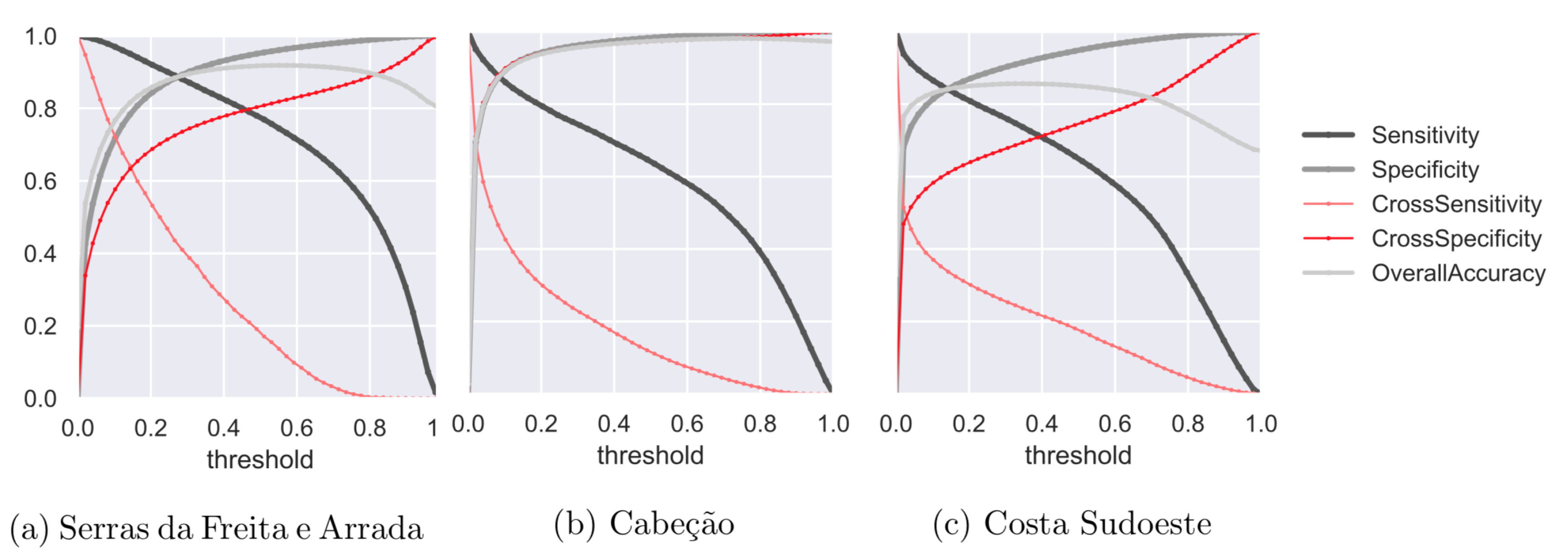
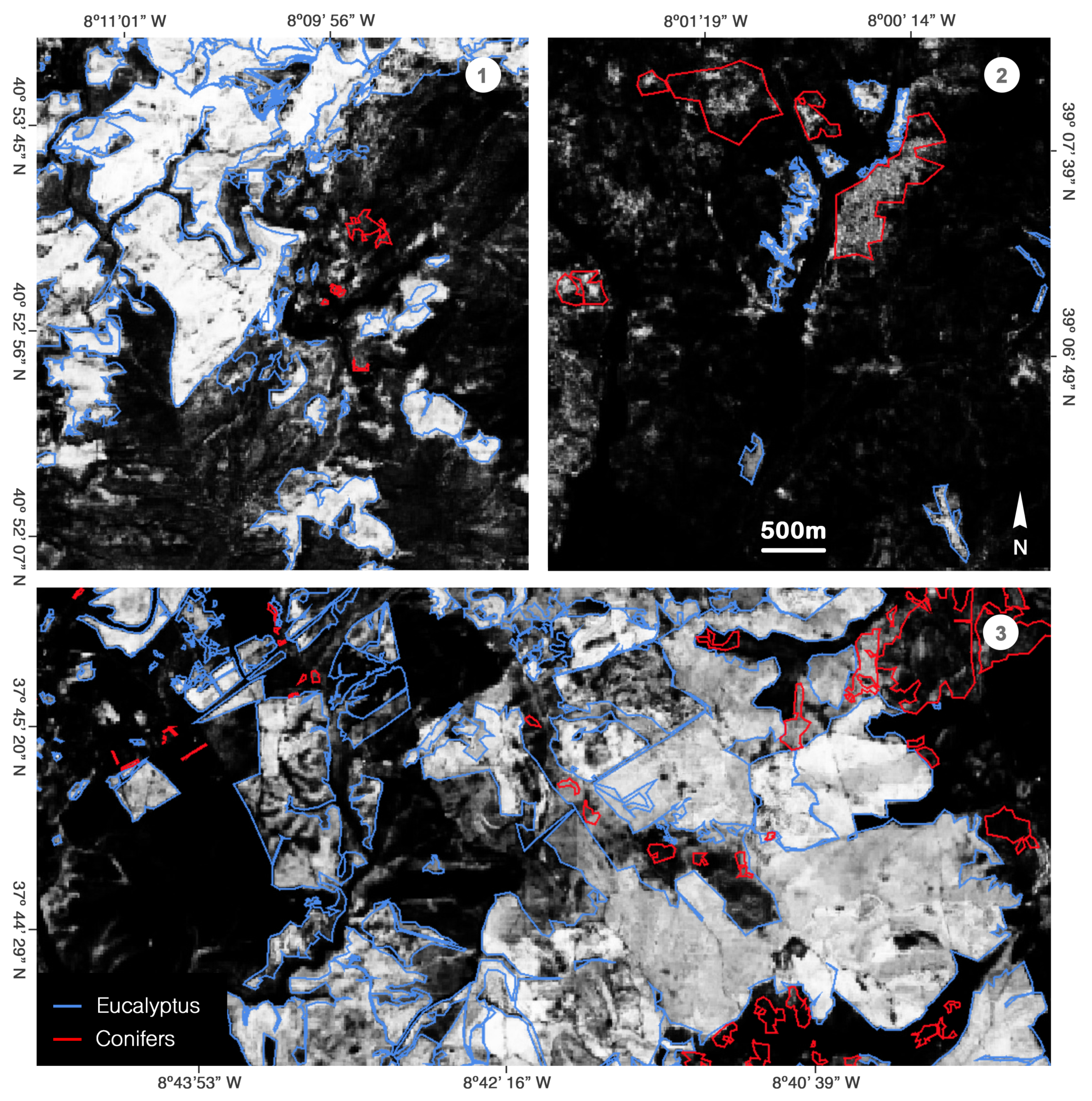
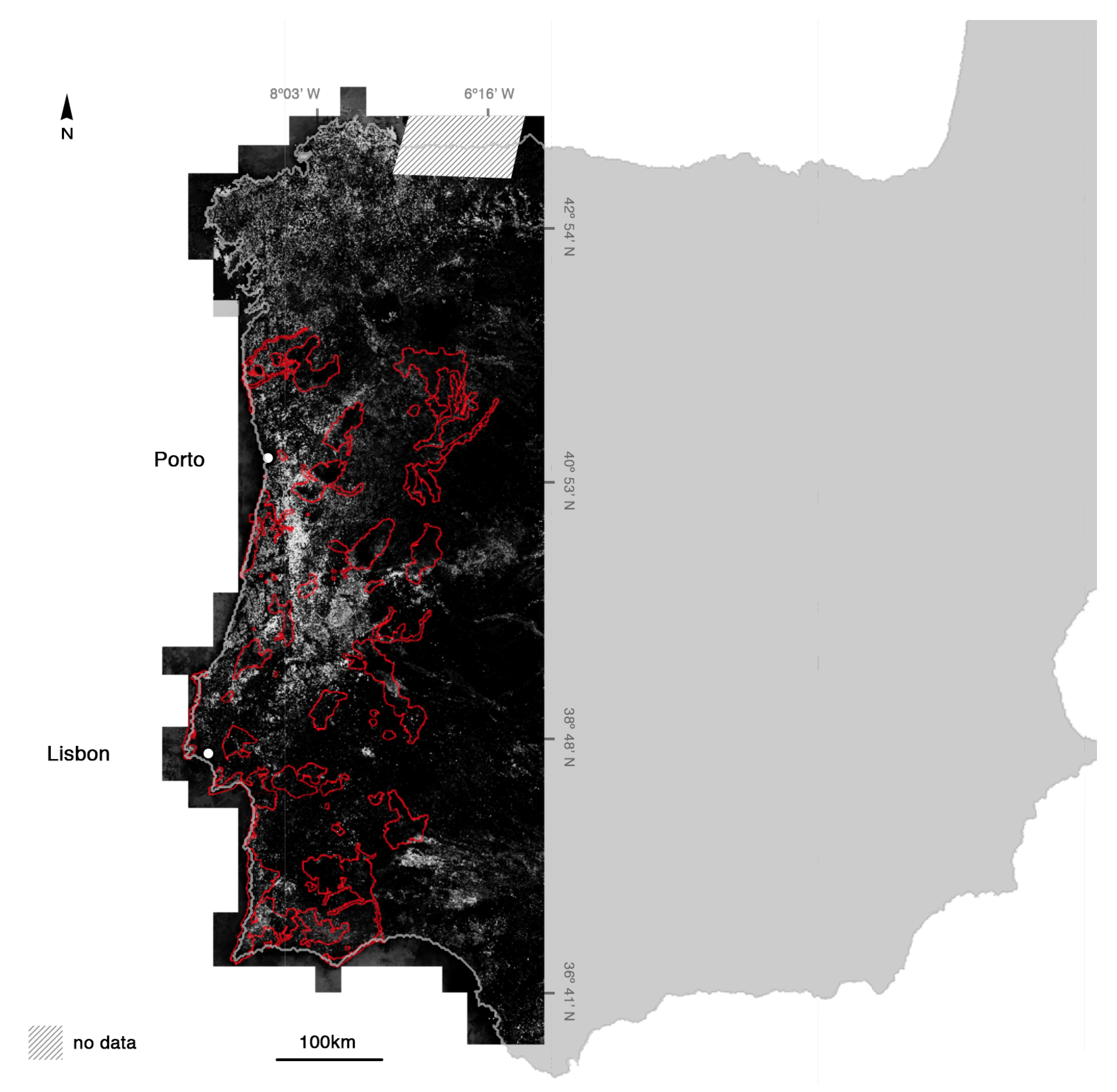
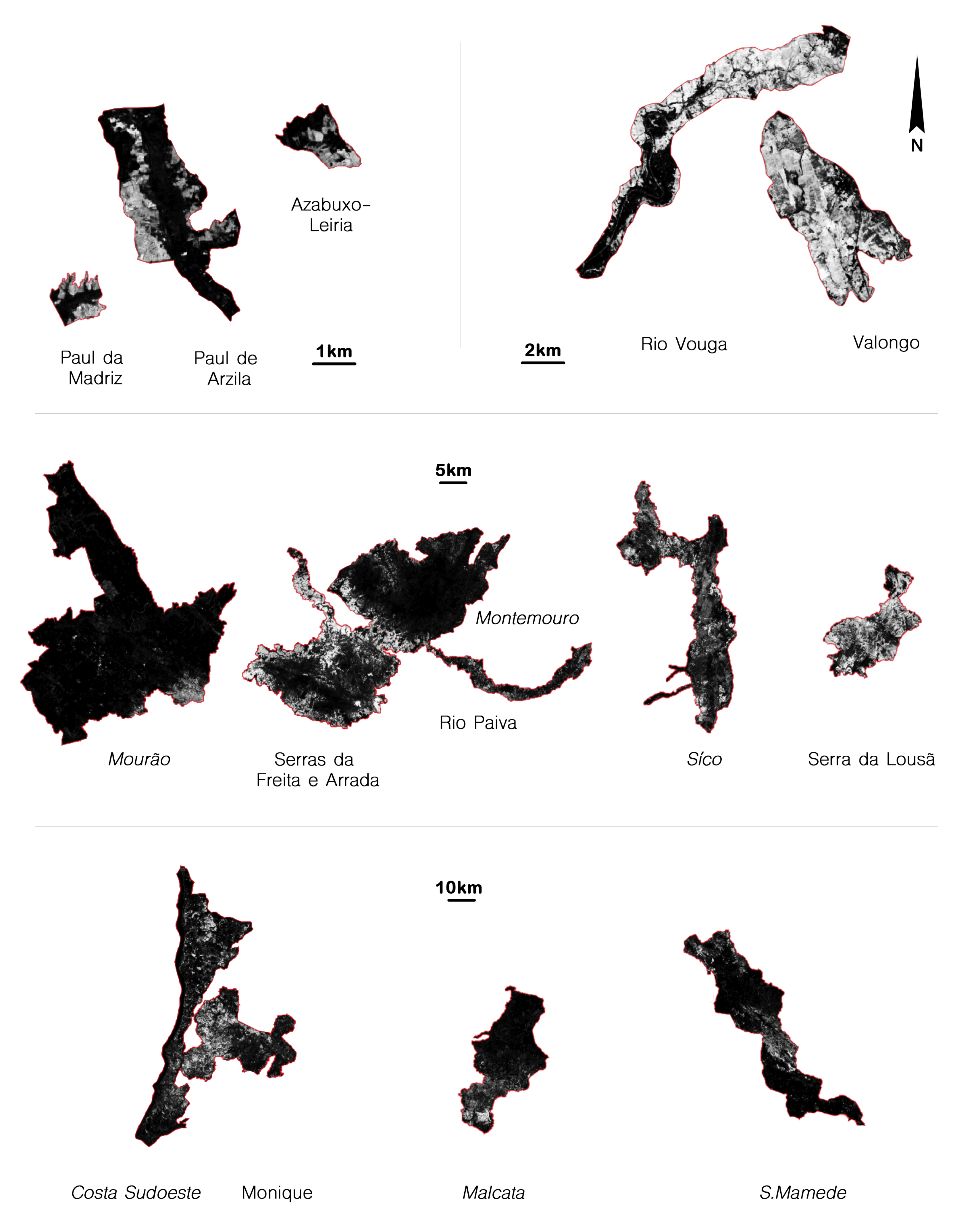
| Band Number | S2A | S2B | Spatial Resolution (m) | ||
|---|---|---|---|---|---|
| Central Wavelength (nm) | Bandwidth (nm) | Central Wavelength (nm) | Bandwidth (nm) | ||
| 1 | 442.7 | 21 | 442.3 | 21 | 60 |
| 2 | 492.4 | 66 | 492.1 | 66 | 10 |
| 3 | 559.8 | 36 | 559.0 | 36 | 10 |
| 4 | 664.6 | 31 | 665.0 | 31 | 10 |
| 5 | 704.1 | 15 | 703.8 | 16 | 20 |
| 6 | 740.5 | 15 | 739.1 | 15 | 20 |
| 7 | 782.8 | 20 | 779.7 | 20 | 20 |
| 8 | 832.8 | 106 | 833.0 | 106 | 10 |
| 8a | 864.7 | 21 | 864.0 | 22 | 20 |
| 9 | 945.1 | 20 | 943.2 | 21 | 60 |
| 10 | 1373.5 | 31 | 1376.9 | 30 | 60 |
| 11 | 1613.7 | 91 | 1610.4 | 94 | 20 |
| 12 | 2202.4 | 175 | 2185.7 | 185 | 20 |
| Reference | ||||||
|---|---|---|---|---|---|---|
| Eucalyptus | Non-Eucalyptus | Total | User’s Accuracy | Producer’s Accuracy | ||
| Model | Eucalyptus | 278,578 | 63,785 | 342,363 | 0.814 | 0.672 |
| Non-Eucalyptus | 136,228 | 2,188,458 | 2,324,686 | 0.941 | 0.972 | |
| Total | 414,806 | 2,252,243 | 2,667,049 | |||
| Natura 2000 Name | Site Code | State |
|---|---|---|
| Azabuxo-Leiria | PTCON0046 | strongly affected |
| Costa Sudoeste | PTCON0012 | affected |
| Malcata | PTCON0004 | affected |
| Monchique | PTCON0037 | strongly affected |
| Montemuro | PTCON0025 | affected |
| Mourão/Moura/Barrancos | PTZPE0045 | affected |
| Paul da Madriz | PTZPE0006 | strongly affected |
| Paul de Arzila | PTCON0005 | strongly affected |
| Rio Paiva | PTCON0059 | strongly affected |
| Rio Vouga | PTCON0026 | strongly affected |
| S. Mamede | PTCON0007 | affected |
| Serras da Freita e Arada | PTCON0047 | strongly affected |
| Serra da Lousã | PTCON0060 | strongly affected |
| Sicó / Alvaiázere | PTCON0045 | affected |
| Valongo | PTCON0024 | strongly affected |
© 2020 by the authors. Licensee MDPI, Basel, Switzerland. This article is an open access article distributed under the terms and conditions of the Creative Commons Attribution (CC BY) license (http://creativecommons.org/licenses/by/4.0/).
Share and Cite
Forstmaier, A.; Shekhar, A.; Chen, J. Mapping of Eucalyptus in Natura 2000 Areas Using Sentinel 2 Imagery and Artificial Neural Networks. Remote Sens. 2020, 12, 2176. https://doi.org/10.3390/rs12142176
Forstmaier A, Shekhar A, Chen J. Mapping of Eucalyptus in Natura 2000 Areas Using Sentinel 2 Imagery and Artificial Neural Networks. Remote Sensing. 2020; 12(14):2176. https://doi.org/10.3390/rs12142176
Chicago/Turabian StyleForstmaier, Andreas, Ankit Shekhar, and Jia Chen. 2020. "Mapping of Eucalyptus in Natura 2000 Areas Using Sentinel 2 Imagery and Artificial Neural Networks" Remote Sensing 12, no. 14: 2176. https://doi.org/10.3390/rs12142176
APA StyleForstmaier, A., Shekhar, A., & Chen, J. (2020). Mapping of Eucalyptus in Natura 2000 Areas Using Sentinel 2 Imagery and Artificial Neural Networks. Remote Sensing, 12(14), 2176. https://doi.org/10.3390/rs12142176


