Centimeter-Level Precise Orbit Determination for the Luojia-1A Satellite Using BeiDou Observations


Abstract
1. Introduction
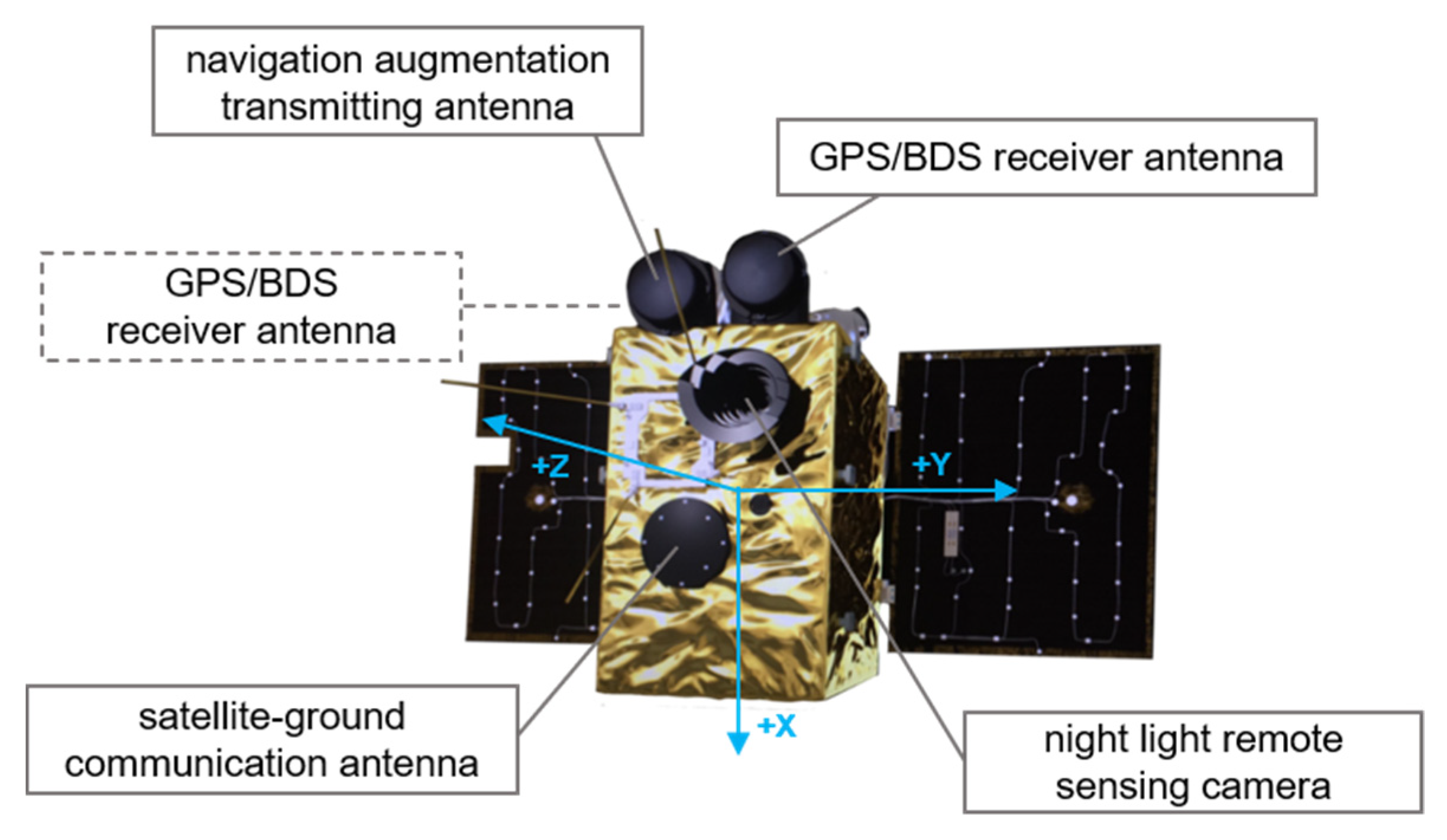
2. Luojia-1A Satellite Platform
3. BeiDou Multipath Modeling with Luojia-1A Observations
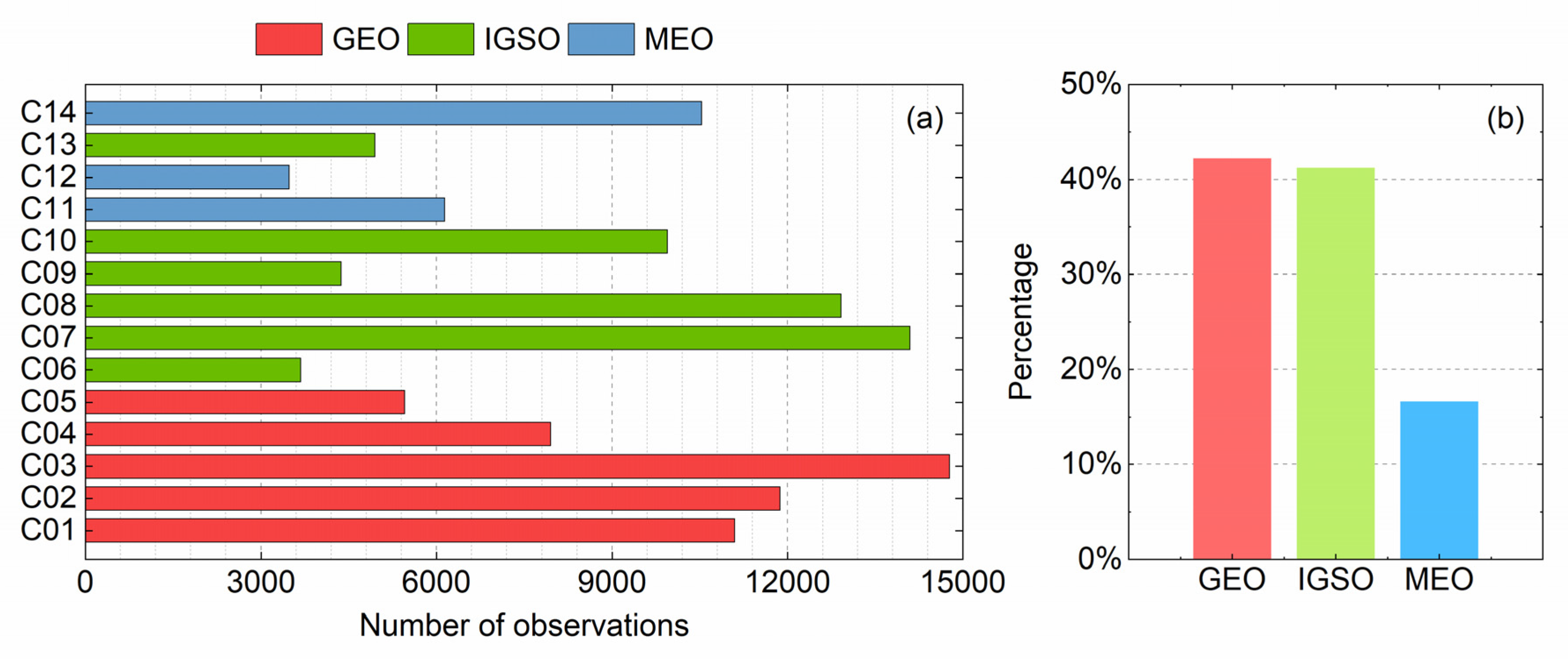
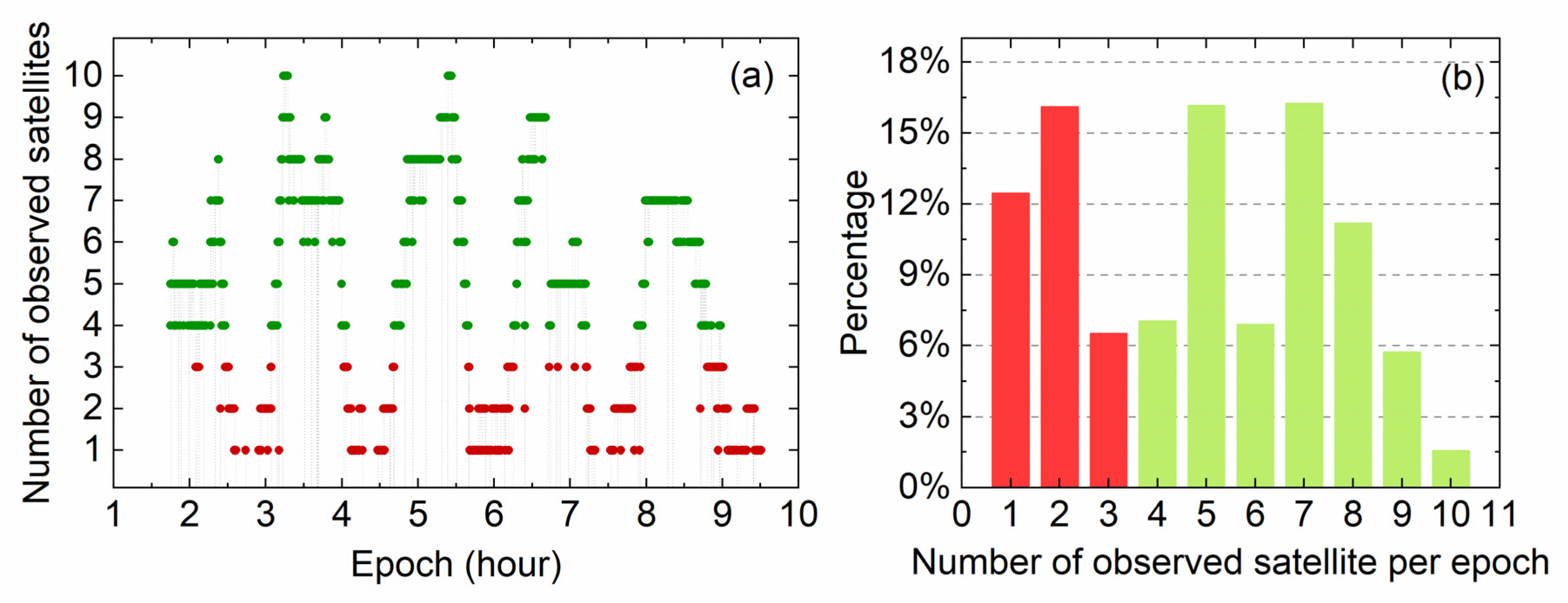
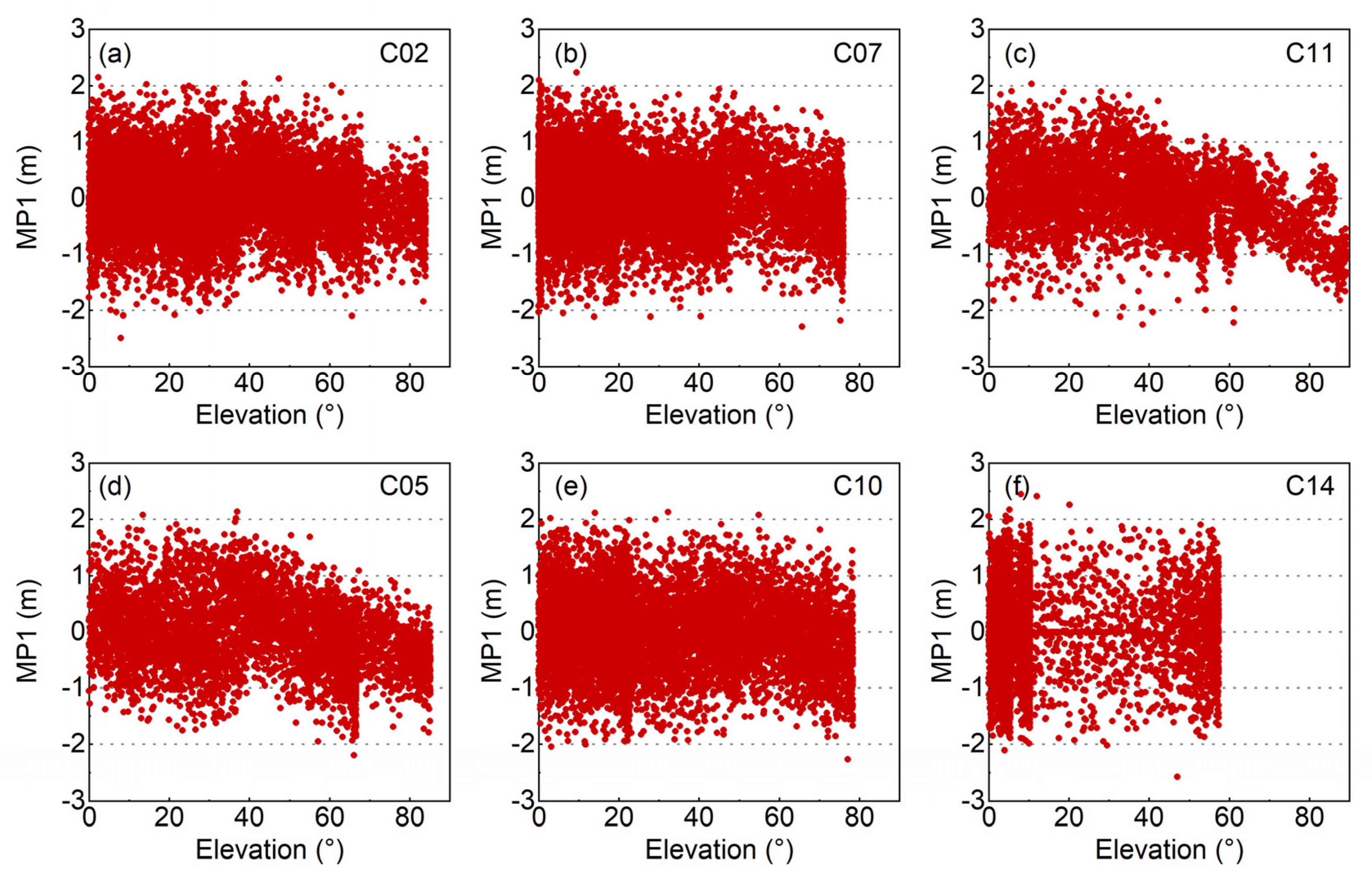
3.1. Data Collection
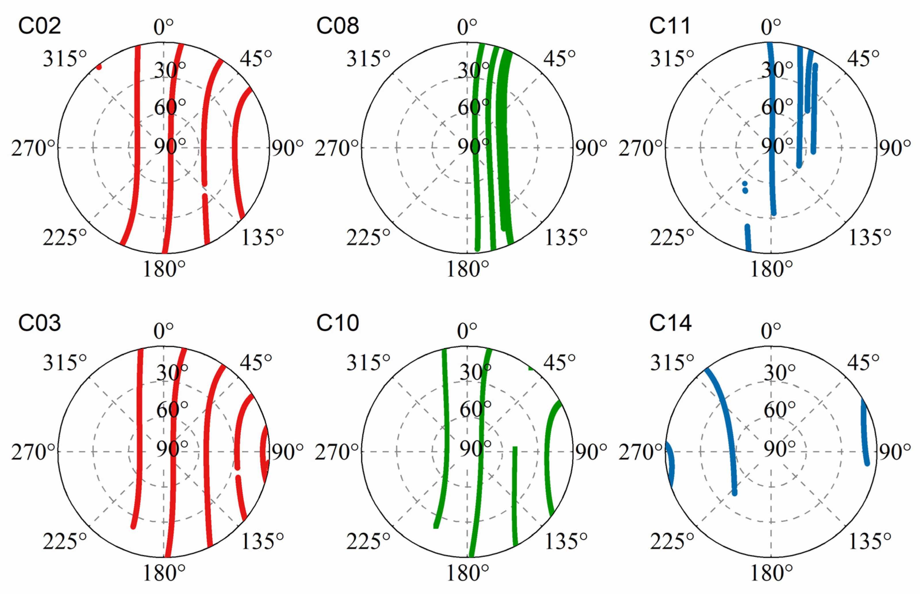
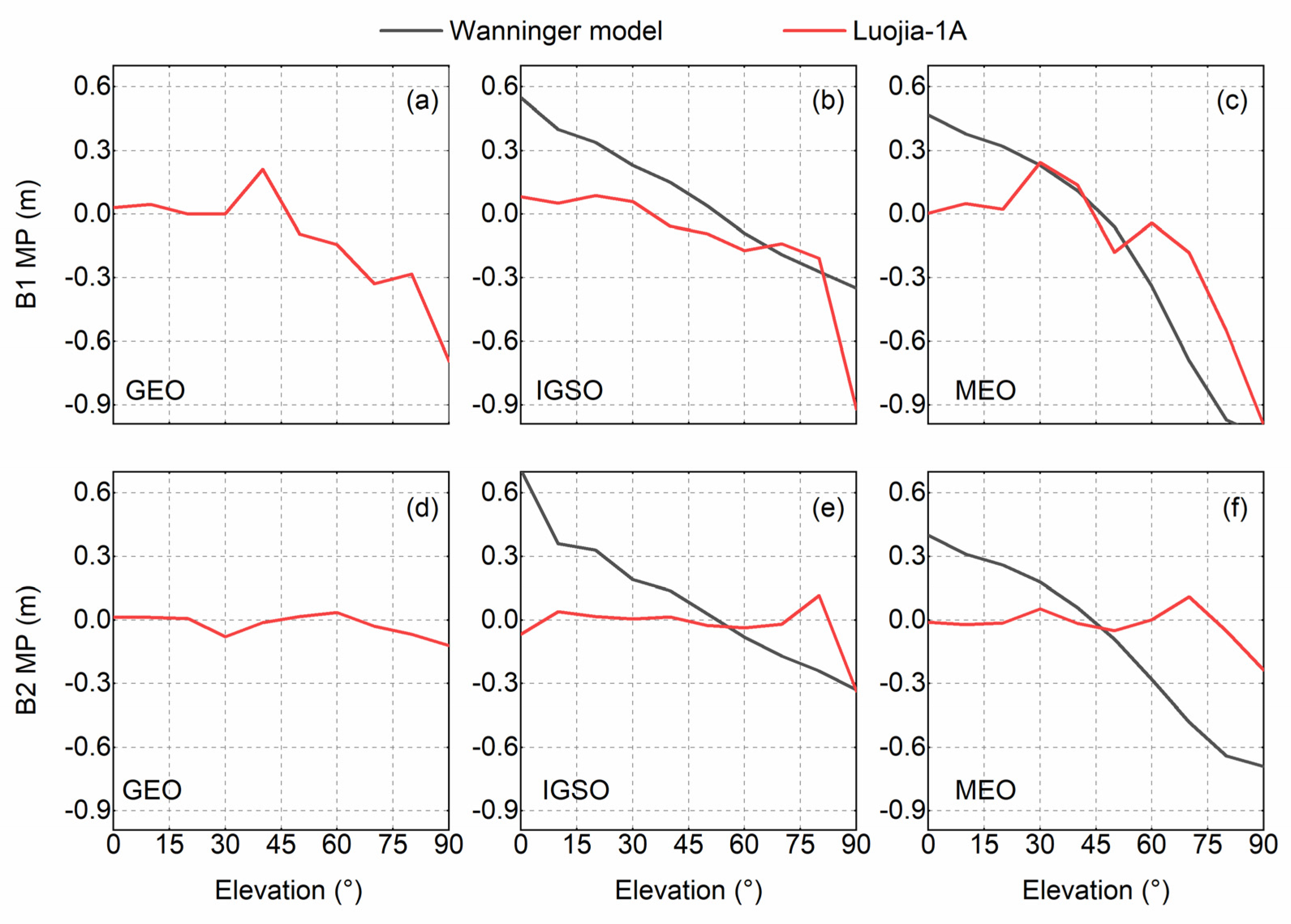
3.2. Modeling the Multipath of BeiDou Observations
4. Methodologies for the Beidou-Based LEO POD
4.1. Theory of Reduce-Dynamic Orbit Determination
4.2. POD Strategy of Luojia-1A Satellite
5. Luojia-1A Satellite POD Results and Discussion
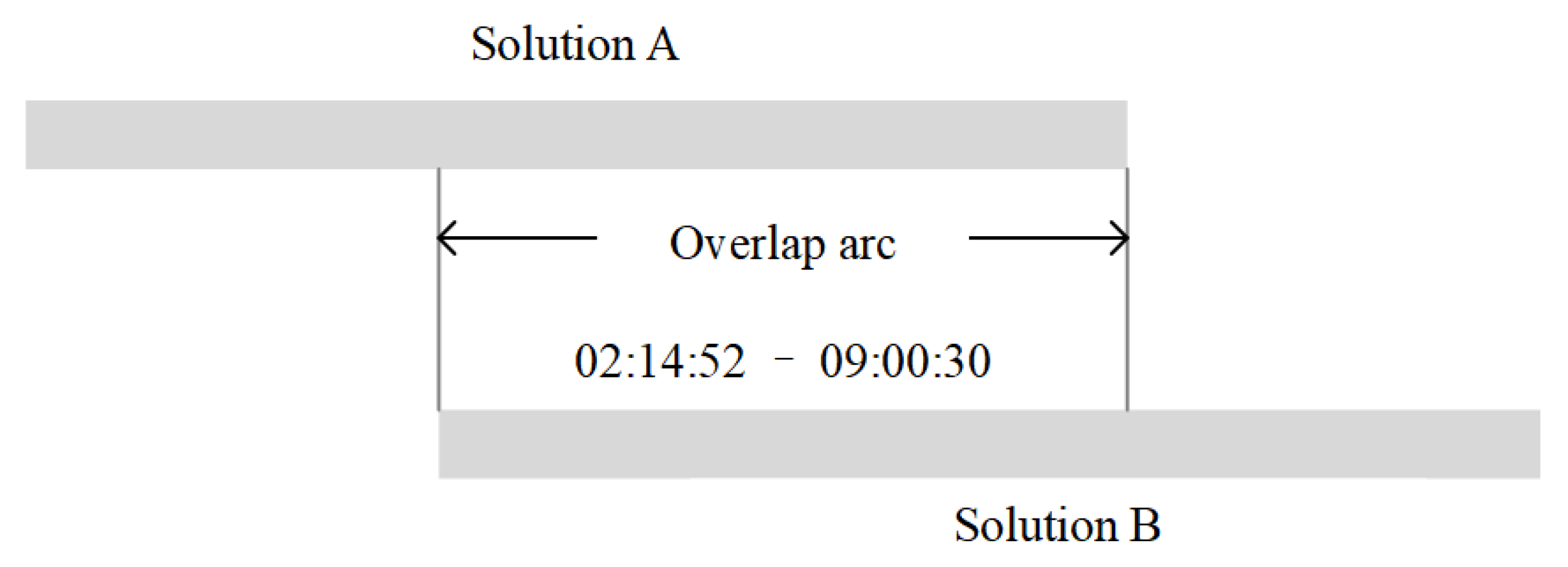
5.1. The Procedure of Luojia-1A Satellite POD
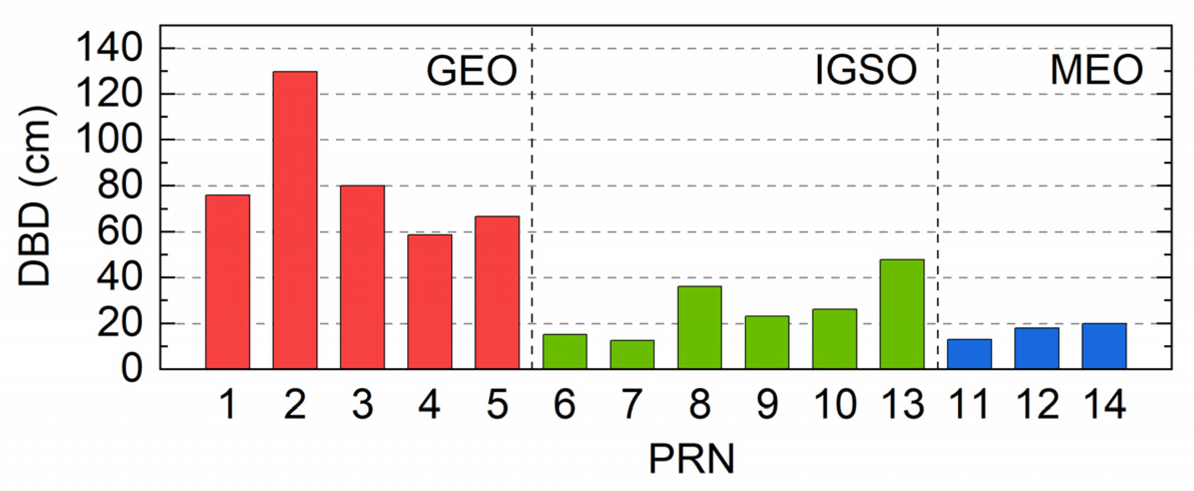
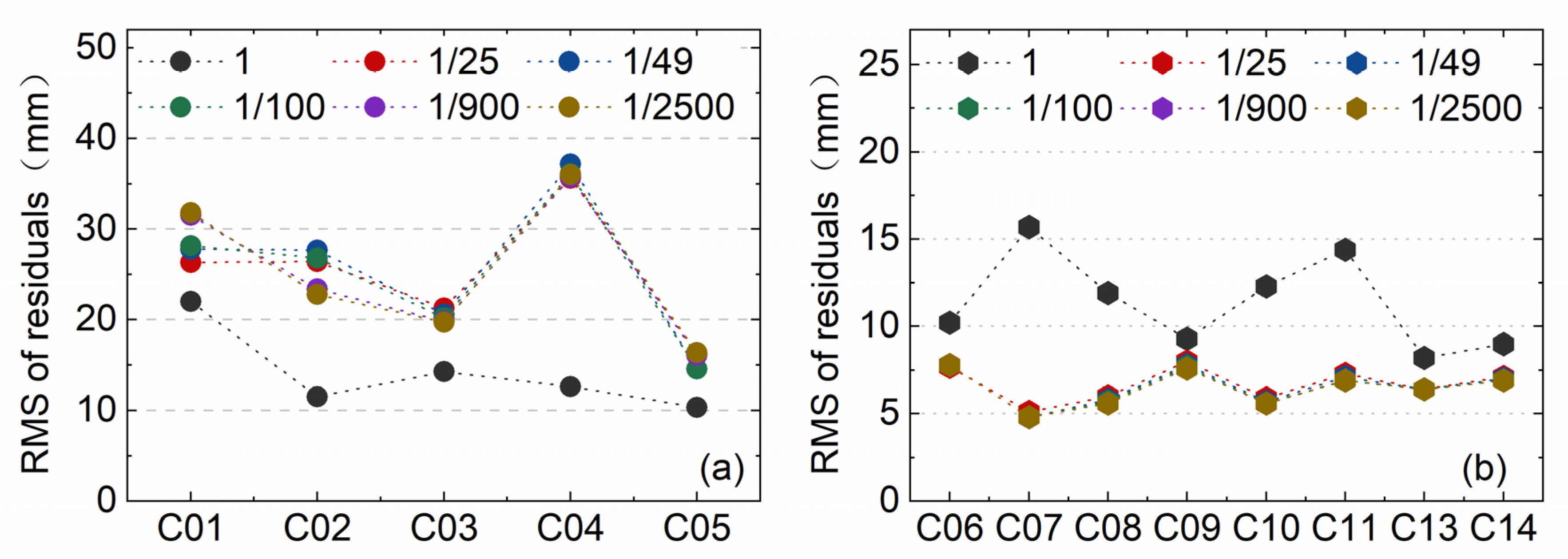
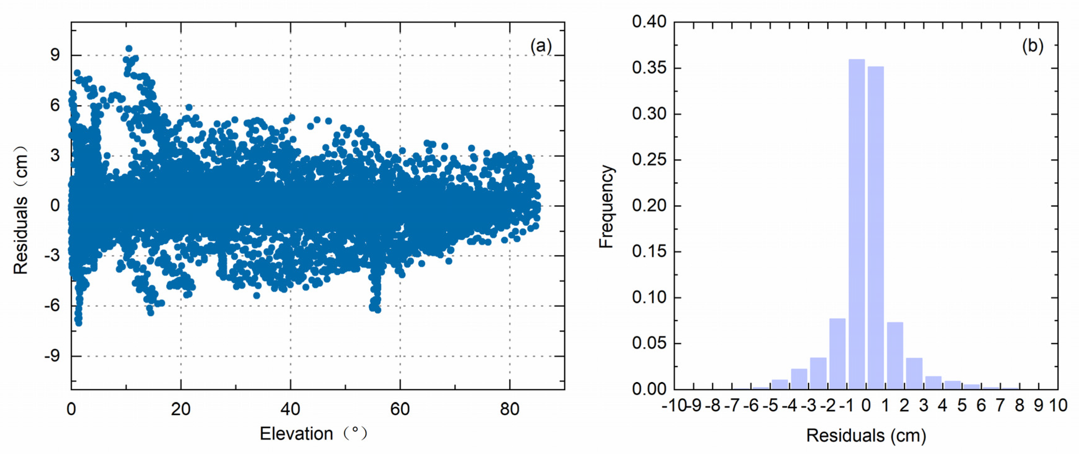
5.2. Precise Orbit Determination with BeiDou Observations
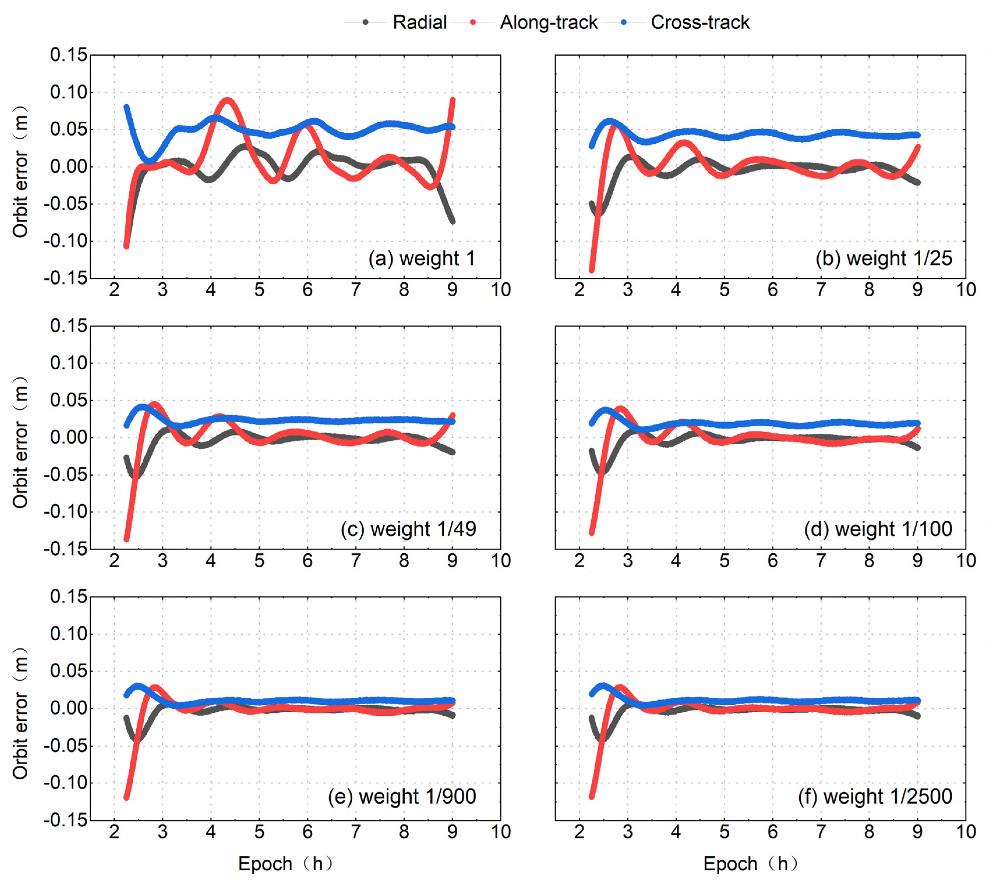
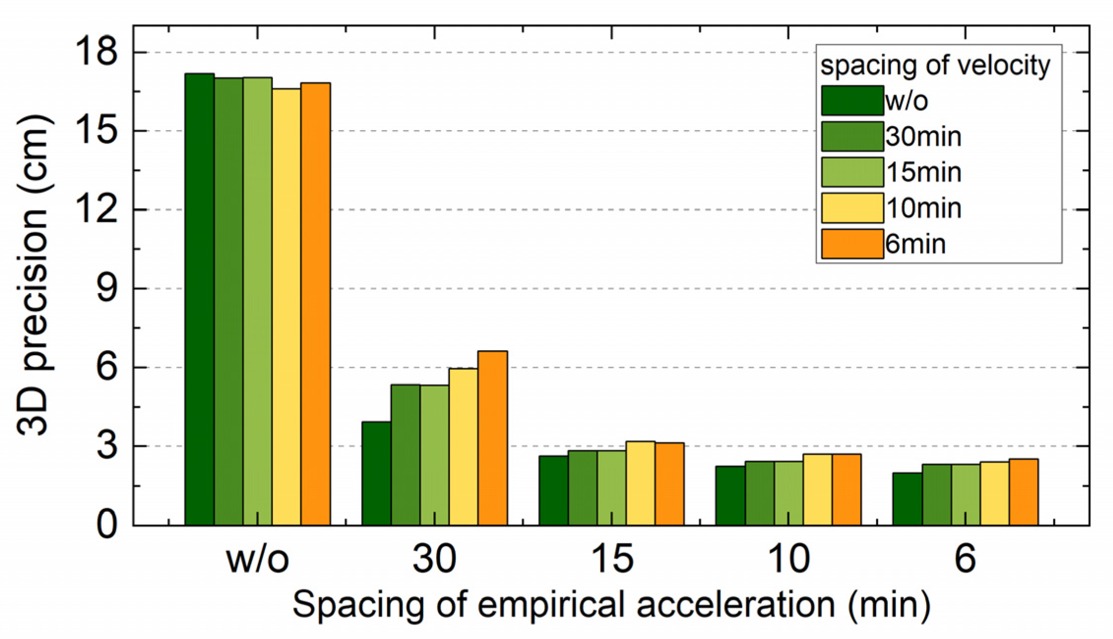
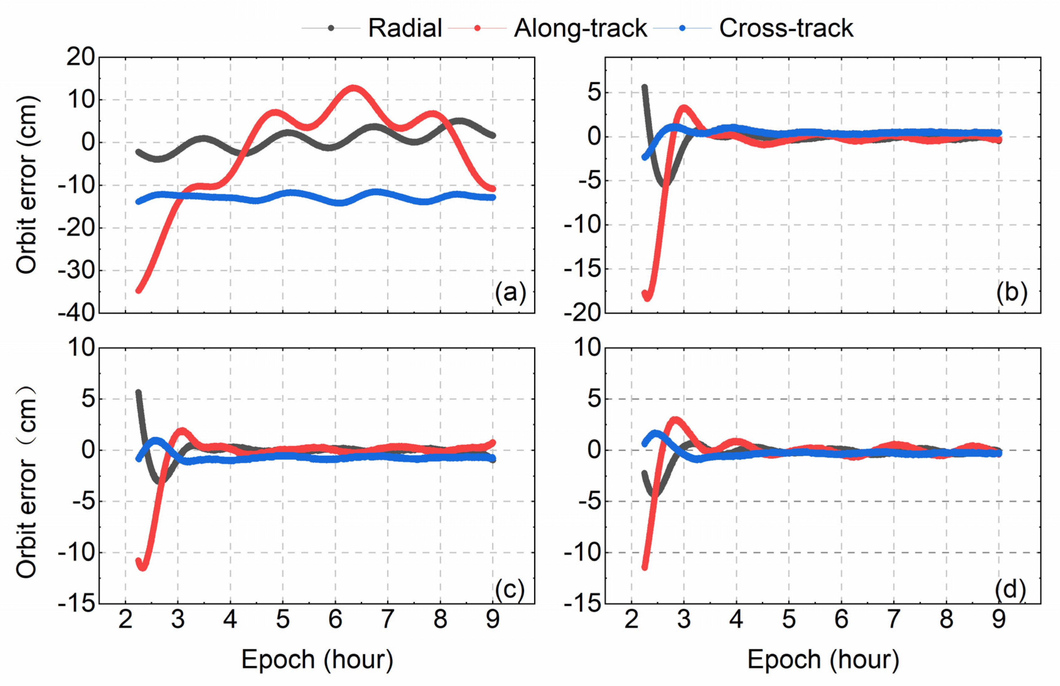
5.3. Tuning the Pseudo-Stochastics Parameters
6. Conclusions
Author Contributions
Funding
Conflicts of Interest
References
- Perosanz, F.; Marty, J.C.; Balmino, G. Dynamic orbit determination and gravity field model improvement from GPS, DORIS and Laser measurements on TOPEX/POSEIDON satellite. J. Geod. 1997, 71, 160–170. [Google Scholar] [CrossRef]
- Bi, Y.; Yang, Z.; Zhang, P.; Sun, Y.; Bai, W.; Du, Q.; Yang, G.; Chen, J.; Liao, M. An introduction to China FY3 radio occultation mission and its measurement simulation. Adv. Space Res. 2012, 49, 1191–1197. [Google Scholar] [CrossRef]
- Hackel, S.; Montenbruck, O.; Steigenberger, P.; Balss, U.; Gisinger, C.; Eineder, M. Model improvements and validation of TerraSAR-X precise orbit determination. J. Geod. 2017, 91, 1–16. [Google Scholar] [CrossRef]
- Li, B.; Ge, H.; Ge, M.; Nie, L.; Shen, Y.; Schuh, H. LEO enhanced Global Navigation Satellite System (LeGNSS) for real-time precise positioning services. Adv. Space Res. 2018, 63, 73–93. [Google Scholar] [CrossRef]
- Wang, L.; Chen, R.; Li, D.; Zhang, G.; Shen, X.; Yu, B.; Wu, C.; Xie, S.; Zhang, P.; Li, M.; et al. Initial Assessment of the LEO Based Navigation signal augmentation System from Luojia-1A Satellite. Sensors 2018, 18, 3919. [Google Scholar] [CrossRef] [PubMed]
- Li, X.; Ma, F.; Li, X.; Lv, H.; Bian, L.; Jiang, Z.; Zhang, X. LEO constellation-augmented multi-GNSS for rapid PPP convergence. J. Geod. 2019, 93, 749–764. [Google Scholar] [CrossRef]
- Wang, L.; Li, D.; Chen, R.; Fu, W.; Shen, X.; Jiang, H. The Low Earth Orbiter (LEO) Navigation Augmentation Technique-Opportunities and Challenges. Strateg. Study CAE 2020, 22, 1–12. [Google Scholar]
- Ge, H.; Li, B.; Ge, M.; Zang, N.; Nie, L.; Shen, Y.; Schuh, H. Initial Assessment of Precise Point Positioning with LEO Enhanced Global Navigation Satellite Systems (LeGNSS). Remote Sens. 2018, 10, 984. [Google Scholar] [CrossRef]
- Li, X.; Lv, H.; Ma, F.; Li, X.; Liu, J.; Jiang, Z. GNSS RTK Positioning Augmented with Large LEO Constellation. Remote Sens. 2019, 11, 228. [Google Scholar] [CrossRef]
- Wang, L.; Li, D.; Chen, R.; Fu, W.; Shen, X.; Jiang, H.; Hao, J. Low Earth Orbiter (LEO) Navigation Augmentation: Opportunities and Challenges. Chin. J. Eng. Sci. 2020, 22, 144. [Google Scholar]
- Yang, Y. Concepts of Comprehensive PNT and Related Key Technologies. Acta Geod. Cartogr. Sin. 2016, 45, 505–510. [Google Scholar]
- Li, D.; Shen, X.; Li, D.; Li, S. On Civil-Military Integrated Space-Based Real-Time Information Service System. Geomat. Inf. Sci. Wuhan Univ. 2017, 42, 1501–1505. [Google Scholar]
- Wang, L.; Chen, R.; Xu, B.; Zhang, X.; Li, T.; Wu, C. The Challenges of LEO Based Navigation Augmentation System Lessons Learned from Luojia-1A Satellite. In China Satellite Navigation Conference (CSNC) 2019 Proceedings; Springer: Beijing, China, 2019; pp. 298–310. [Google Scholar]
- Bertiger, W.; Bar-Sever, Y.; Christensen, E.; Davis, E.; Guinn, J.; Haines, B.; Ibanez-Meier, R.; Jee, J.; Lichten, S.; Melbourne, W.; et al. GPS precise tracking of TOPEX/Poseidon: Results and implications. J. Geophys. Res. 1994, 99, 24449–24464. [Google Scholar] [CrossRef]
- Van den Ijssel, J.; Visser, P.; Patiño Rodriguez, E. Champ precise orbit determination using GPS data. Adv. Space Res. 2003, 31, 1889–1895. [Google Scholar] [CrossRef]
- Jäggi, A.; Hugentobler, U.; Bock, H.; Beutler, G. Precise orbit determination for GRACE using undifferenced or doubly differenced GPS data. Adv. Space Res. 2007, 39, 1612–1619. [Google Scholar] [CrossRef]
- Bock, H.; Jäggi, A.; Švehla, D.; Beutler, G.; Hugentobler, U.; Visser, P. Precise orbit determination for the GOCE satellite using GPS. Adv. Space Res. 2007, 39, 1638–1647. [Google Scholar] [CrossRef]
- Montenbruck, O.; Hackel, S.; van den Ijssel, J.; Arnold, D. Reduced dynamic and kinematic precise orbit determination for the Swarm mission from 4 years of GPS tracking. Gps Solut. 2018, 22, 79. [Google Scholar] [CrossRef]
- Montenbruck, O.; Hauschild, A.; Steigenberger, P.; Hugentobler, U.; Teunissen, P.; Nakamura, S. Initial assessment of the COMPASS/BeiDou-2 regional navigation satellite system. GPS Solut. 2013, 17, 211–222. [Google Scholar] [CrossRef]
- Zhang, X.; Wu, M.; Liu, W.; Li, X.; Yu, S.; Lu, C.; Wickert, J. Initial assessment of the COMPASS/BeiDou-3: New-generation navigation signals. J. Geod. 2017, 91, 1225–1240. [Google Scholar] [CrossRef]
- Chen, X.; Zhao, S.; Wang, M.; Lu, M. Space-borne BDS receiver for LING QIAO satellite: Design, implementation and preliminary in-orbit experiment results. GPS Solut. 2016, 20, 837–847. [Google Scholar] [CrossRef]
- Li, M.; Li, W.; Shi, C.; Jiang, K.; Guo, X.; Dai, X.; Meng, X.; Yang, Z.; Yang, G.; Liao, M. Precise orbit determination of the Fengyun-3C satellite using onboard GPS and BDS observations. J. Geod. 2017, 91, 1313–1327. [Google Scholar] [CrossRef]
- Zhang, Q.; Guo, X.; Qu, L.; Zhao, Q. Precise Orbit Determination of FY-3C with Calibration of Orbit Biases in BeiDou GEO Satellites. Remote Sens. 2018, 10, 382. [Google Scholar] [CrossRef]
- Wanninger, L.; Beer, S. BeiDou satellite-induced code pseudorange variations: Diagnosis and therapy. GPS Solut. 2015, 19, 639–648. [Google Scholar] [CrossRef]
- Wang, L. Reliability Control of GNSS Carrier-Phase Integer Ambiguity Resolution. Ph.D. Thesis, Queensland University of Technology, Brisbane, Australia, 2015. [Google Scholar]
- Wang, L.; Feng, Y.; Wang, C. Real-Time Assessment of GNSS Observation Noise with Single Receivers. J. Glob. Position Syst. 2013, 12, 73–82. [Google Scholar]
- Guo, J.; Xu, X.; Zhao, Q.; Liu, J. Precise orbit determination for quad-constellation satellites at Wuhan University: Strategy, result validation, and comparison. J. Geod. 2016, 90, 143–159. [Google Scholar] [CrossRef]
- Griffiths, J.; Ray, J.R. On the precision and accuracy of IGS orbits. J. Geod. 2009, 83, 277–287. [Google Scholar] [CrossRef]
- Montenbruck, O.; Gill, E. Lutze F. Satellite orbits: Models, methods, and applications. Appl. Mech. Rev. 2002, 55, B27–B28. [Google Scholar] [CrossRef]
- Jäggi, A.; Hugentobler, U.; Beutler, G. Pseudo-Stochastic Orbit Modeling Techniques for Low-Earth Orbiters. J. Geod. 2006, 80, 47–60. [Google Scholar] [CrossRef]


| Type of Parameter | Settings |
|---|---|
| Observations | BDS B1 and B2 code and carrier-phase observations |
| Sample rate | 5 s |
| Cut off angle | 0º |
| BeiDou antenna phase center | PCV.atx [27] |
| Relativistic effects | IERS 2010 |
| Ionospheric error | Ionosphere-free linear combination |
| Earth rotation | ERP products Provided by Wuhan University |
| Nutation | IAU2000R06 |
| Polar motion | IERS2010XY |
| BeiDou precise orbit and clock products | WUM products Provided by Wuhan University |
| Earth’s gravity field | EGM2008 model with the degree of 120 |
| Solid Earth tides | IERS 2010 |
| Ocean tides | FES 2004 |
| Planetary calendar | DE405 |
| Solar pressure | ECOM |
| Pseudo-stochastic parameters | Radial, along-track, and cross-track directions |
| Institution | Indicate | Constellations | Orbit | Clocks | ERP |
|---|---|---|---|---|---|
| CODE | COM | GPS + GLO + GAL + BDS + QZS | 5 min | 30 s/5 min | 12 h |
| GFZ | GBM | GPS + GLO + GAL + BDS + QZS | 15 min | 30 s/5 min | 24 h |
| WHU | WUM | GPS + GLO + GAL + BDS + QZS | 15 min | 30 s/5 min | 24 h |
| TUM | TUM | GAL + BDS + QZS | 5 min | 5 min | / |
| GEO | IGSO | MEO | |
|---|---|---|---|
| 3D DBD | 82.28 | 26.74 | 17.00 |
| Scheme ID | A | B | C | D | E | F |
|---|---|---|---|---|---|---|
| Weighting Strategy | 1 | 1/25 | 1/49 | 1/100 | 1/900 | 1/2500 |
| Weight | Radial | Along-Track | Cross-Track | 3D | Improvement |
|---|---|---|---|---|---|
| 1 | 2.02 | 3.32 | 5.00 | 6.333 | / |
| 1/25 | 1.50 | 2.29 | 4.37 | 5.157 | 18.57% |
| 1/49 | 1.28 | 2.20 | 2.45 | 3.533 | 44.21% |
| 1/100 | 1.11 | 2.00 | 1.98 | 3.025 | 52.23% |
| 1/900 | 0.94 | 1.75 | 1.19 | 2.316 | 63.43% |
| 1/2500 | 0.94 | 1.73 | 1.23 | 2.322 | 63.43% |
| Accelerations Interval | Radial | Along-Track | Cross-Track | 3D |
|---|---|---|---|---|
| w/o | 2.43 | 11.17 | 12.83 | 17.184 |
| 30 min | 1.30 | 3.66 | 0.62 | 3.933 |
| 15 min | 0.84 | 2.37 | 0.77 | 2.630 |
| 10 min | 0.74 | 1.99 | 0.73 | 2.245 |
| 6 min | 0.99 | 1.66 | 0.52 | 2.002 |
© 2020 by the authors. Licensee MDPI, Basel, Switzerland. This article is an open access article distributed under the terms and conditions of the Creative Commons Attribution (CC BY) license (http://creativecommons.org/licenses/by/4.0/).
Share and Cite
Wang, L.; Xu, B.; Fu, W.; Chen, R.; Li, T.; Han, Y.; Zhou, H. Centimeter-Level Precise Orbit Determination for the Luojia-1A Satellite Using BeiDou Observations. Remote Sens. 2020, 12, 2063. https://doi.org/10.3390/rs12122063
Wang L, Xu B, Fu W, Chen R, Li T, Han Y, Zhou H. Centimeter-Level Precise Orbit Determination for the Luojia-1A Satellite Using BeiDou Observations. Remote Sensing. 2020; 12(12):2063. https://doi.org/10.3390/rs12122063
Chicago/Turabian StyleWang, Lei, Beizhen Xu, Wenju Fu, Ruizhi Chen, Tao Li, Yi Han, and Haitao Zhou. 2020. "Centimeter-Level Precise Orbit Determination for the Luojia-1A Satellite Using BeiDou Observations" Remote Sensing 12, no. 12: 2063. https://doi.org/10.3390/rs12122063
APA StyleWang, L., Xu, B., Fu, W., Chen, R., Li, T., Han, Y., & Zhou, H. (2020). Centimeter-Level Precise Orbit Determination for the Luojia-1A Satellite Using BeiDou Observations. Remote Sensing, 12(12), 2063. https://doi.org/10.3390/rs12122063