Comprehensive Evaluation of Using TechDemoSat-1 and CYGNSS Data to Estimate Soil Moisture over Mainland China
Abstract
1. Introduction
- (1)
- No study compares the current two existing spaceborne GNSS-R missions (i.e., TDS-1 and CYGNSS) whose data are publicly available. The two missions and their data have several common points (e.g., the same payload SGR-ReSI and the same key observable DDM SNR for SM sensing). Precisely because of this situation, the comparisons between them will bring new insights into better using their data and provide reference information for designation of future GNSS-R payloads for soil moisture sensing.
- (2)
- No attempt has been made to evaluate the performance of using the two data to estimate both daily and monthly SM, and a few studies focused on comparing the SM derived from CYGNSS with the SM derived from limited numbers of in situ sites.
2. Data and Methods
2.1. Spaceborne GNSS-R Dataset
2.2. In Situ Measurements
2.3. Calculation of the Daily Surface Reflectivity (SR) and the Effective Reflected Power (Pr,eff)
2.4. Monthly SM Estimation Using Neural Network
3. Results and Comparisons
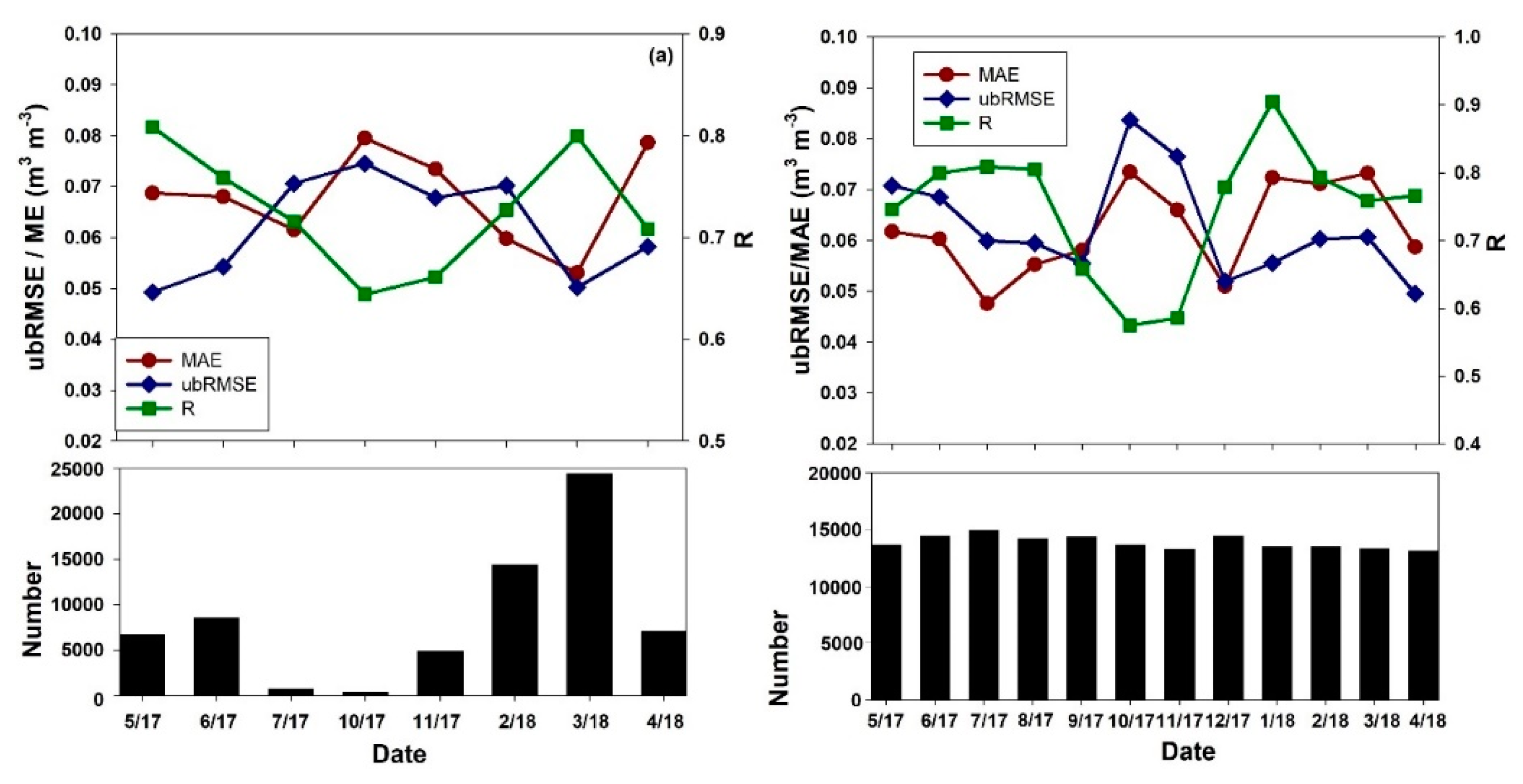
3.1. Sensitivity Analysis from TDS-1 and CYGNSS on a Daily Basis
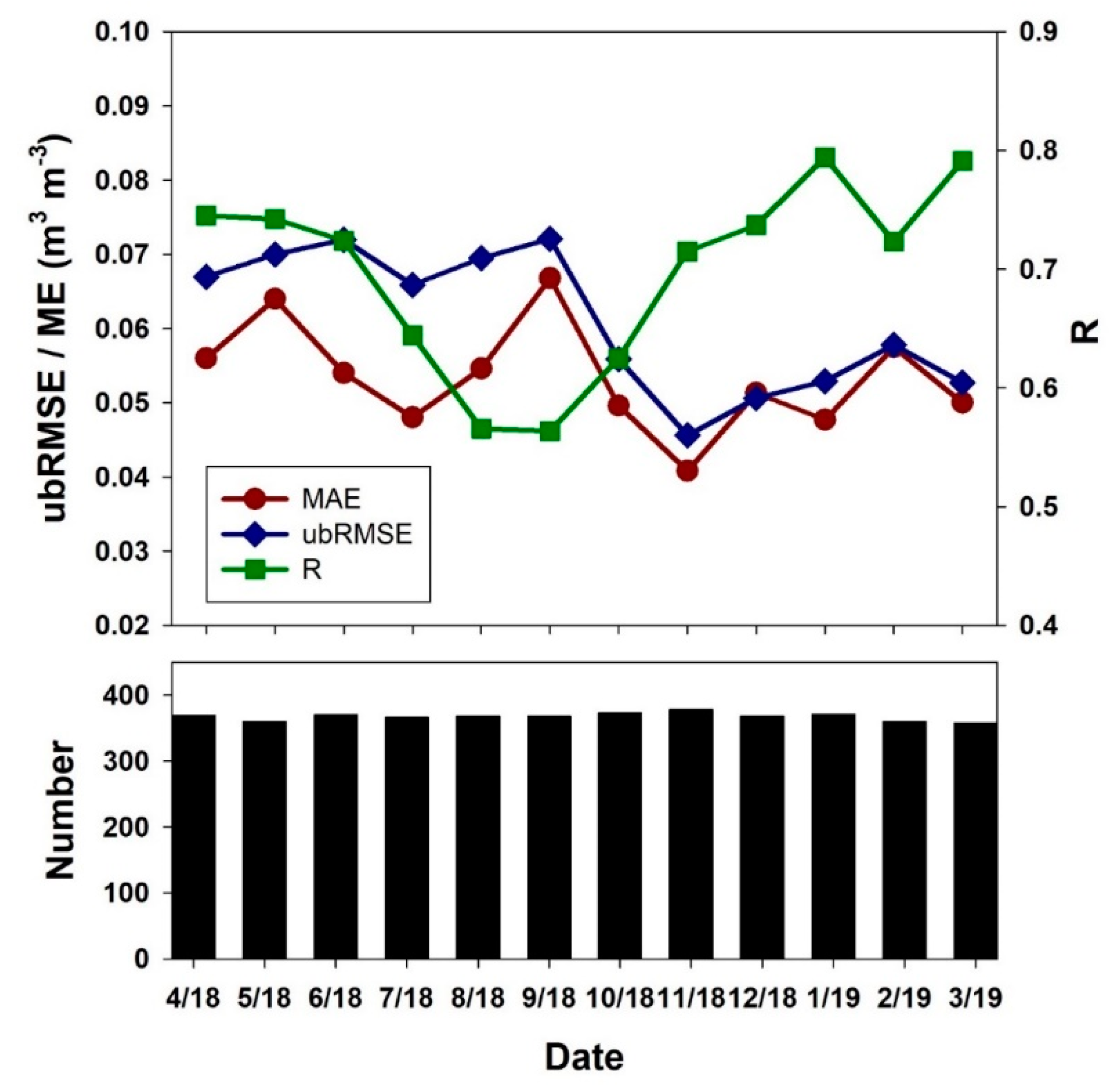
3.2. SM Estimation From TDS-1 and CYGNSS on a Monthly Basis
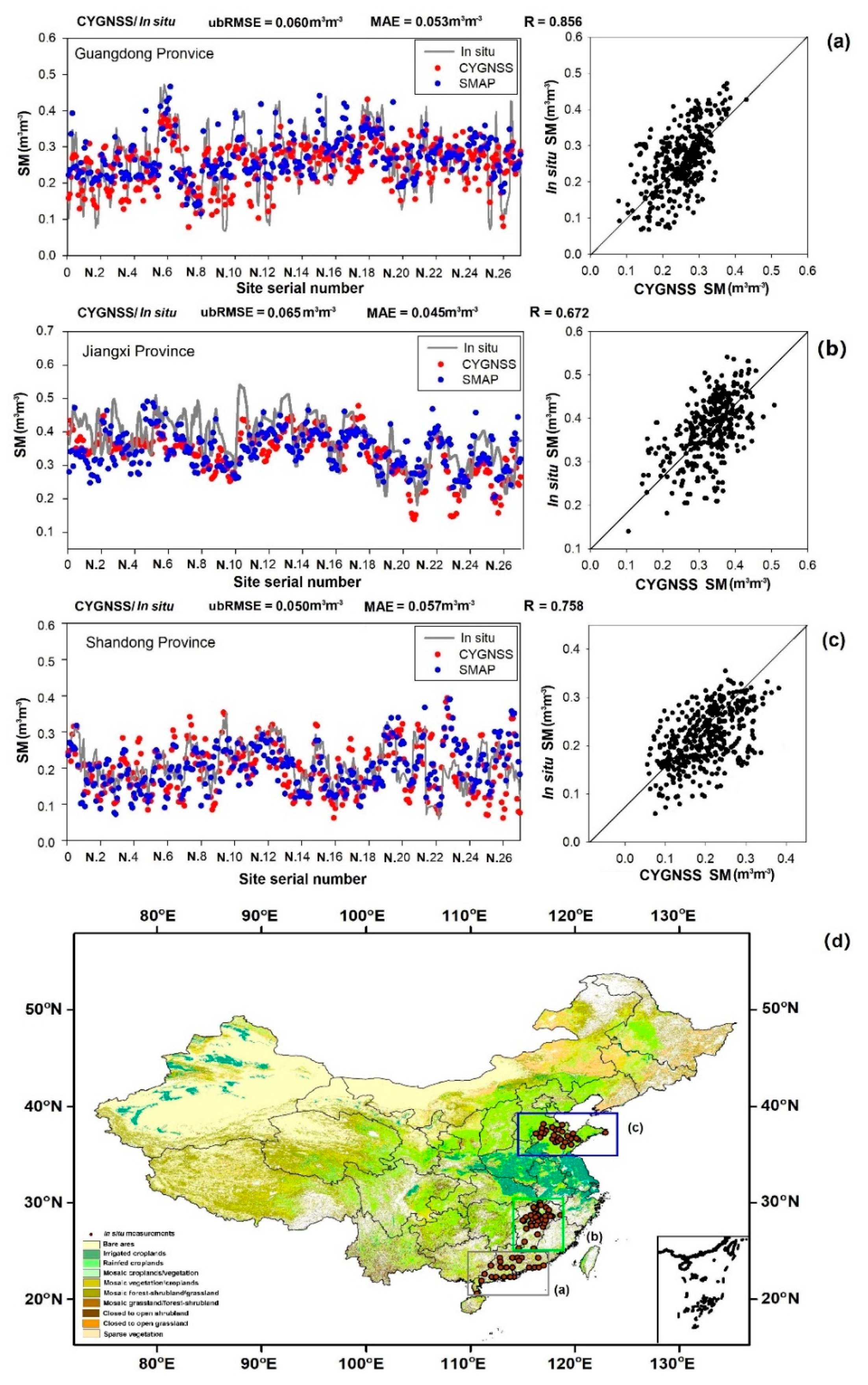
3.3. Validation of TDS-1 and CYGNSS Results with in Situ Measurements
4. Discussion
4.1. Issues Related to the BP-ANN Model
4.2. Advantages and Limitations of Spaceborne GNSS-R for Estimating SM
- Different spatial scales between in situ/SMAP points and TDS-1/CYGNSS points. Although ground measurements from dense sites were used to reduce this well-known issue, the differences in spatial resolution continue to introduce deviations. Future research may consider downscaling the SMAP SM product to the same resolution as the GNSS-R.
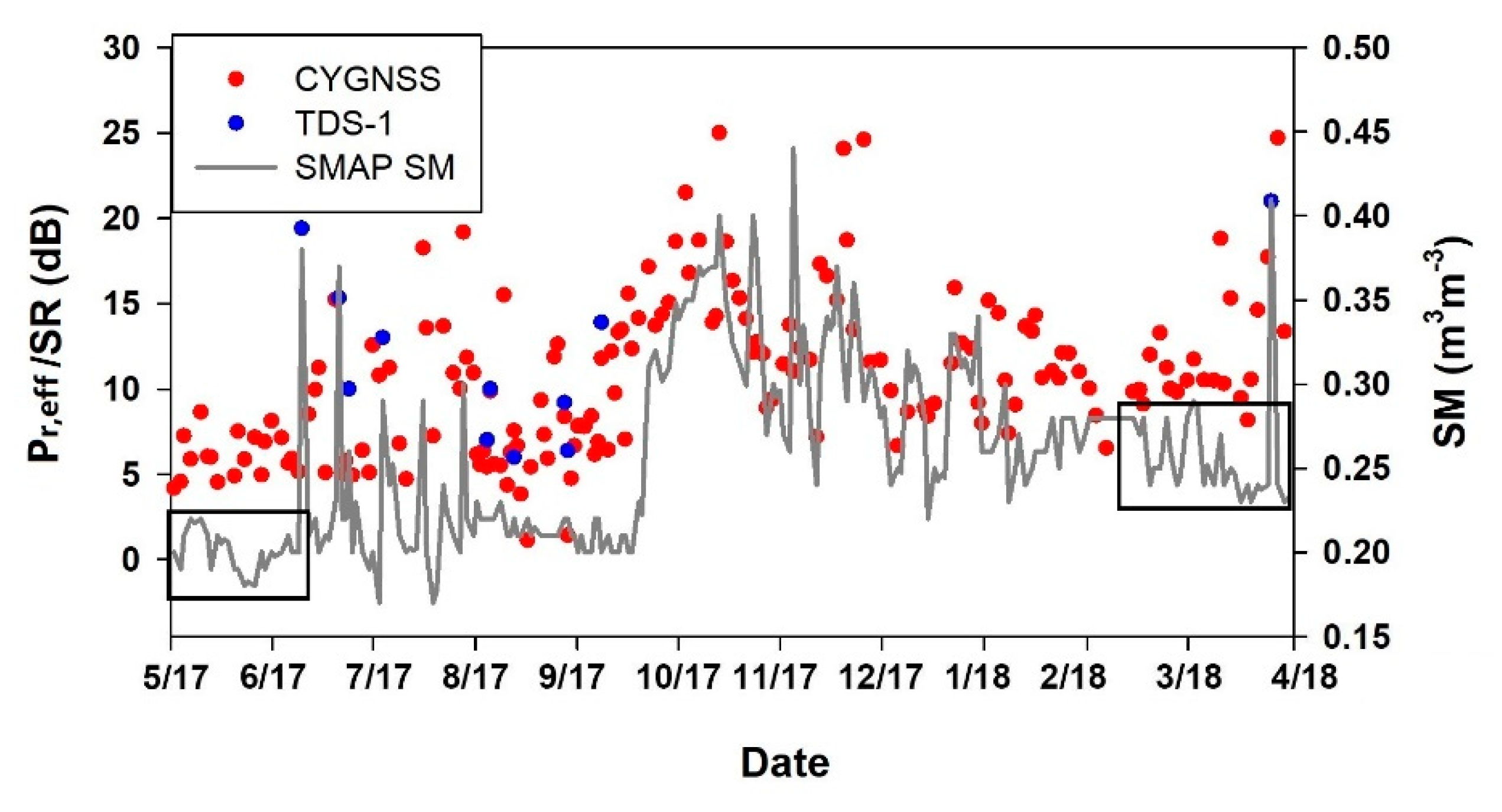
- Effects in terms of VWC, roughness, and elevation etc. For daily sensitivity analysis results, the vegetation severely affects the accuracy of SM, particularly over the central part of Mainland China (VWC > 6 kg/m2 vs. R < 0.6). The accuracies of monthly results were improved since these variables were considered in the proposed neural network model. Nevertheless, surface roughness and complex terrain environments may still reduce the estimation accuracy. Subsequent research may attempt to a potential way to reduce this impact by using changes instead of absolute reflectivity values.
- Mismatch between the depth of microwave penetration and the depth of in situ SM measurements. The in situ measurements used for validation are at 10 cm, whilst the GNSS L-band signal has various penetration depths between 0 cm and 20 cm, depending on the soil’s wetness, as Camp et al. shown in [8].
- Difficulty of matching different remote sensing datasets to each other and the GNSS-R daily values. As mentioned before, the daily MODIS NDVI data set is severely affected by cloud and fog, and currently NDVI does not have a commonly used product. Future study may focus on generation of daily continuous surface soil moisture of high spatial resolution using spaceborne GNSS-R data; daily NDVI estimation method as Zhao et al. proposed [43] may be a good inspiration.
5. Conclusions
Author Contributions
Funding
Acknowledgments
Conflicts of Interest
References
- Rodriguez-Alvarez, N.; Camps, A.; Vall-Llossera, M.; Bosch-Lluis, X.; Monerris, A.; Ramos-Perez, I.; Valencia, E.; Marchan-Hernandez, J.F.; Martinez-Fernandez, J.; Baroncini-Turricchia, G.; et al. Land geophysical parameters retrieval using the interference pattern GNSS-R technique. IEEE Trans. Geosci. Remote 2010, 49, 71–84. [Google Scholar] [CrossRef]
- Cardellach, E.; Rius, A.; Martín-Neira, M.; Fabra, F.; Nogués-Correig, O.; Ribó, S.; D’Addio, S. Consolidating the precision of interferometric GNSS-R ocean altimetry using airborne experimental data. IEEE Trans. Geosci. Remote 2013, 52, 4992–5004. [Google Scholar] [CrossRef]
- Clarizia, M.P.; Gommenginger, C.P.; Gleason, S.T.; Srokosz, M.A.; Galdi, C.; Di Bisceglie, M. Analysis of GNSS-R delay-Doppler maps from the UK-DMC satellite over the ocean. Geophys. Res. Lett. 2009, 36, 2. [Google Scholar] [CrossRef]
- Clarizia, M.P.; Gommenginger, C.; Di Bisceglie, M.; Galdi, C.; Srokosz, M.A. Simulation of L-band bistatic returns from the ocean surface: A facet approach with application to ocean GNSS reflectometry. IEEE Trans. Geosci. 2011, 50, 960–971. [Google Scholar] [CrossRef]
- Foti, G.; Gommenginger, C.; Jales, P.; Unwin, M.; Shaw, A.; Robertson, C.; Rosello, J. Spaceborne GNSS reflectometry for ocean winds: First results from the UK TechDemoSat-1 mission. Geophys. Res. Lett. 2015, 42, 5435–5441. [Google Scholar] [CrossRef]
- Chew, C.; Shah, R.; Zuffada, C.; Hajj, G.; Masters, D.; Mannucci, A.J. Demonstrating soil moisture remote sensing with observations from the UK TechDemoSat-1 satellite mission. Geophys. Res. Lett. 2016, 43, 3317–3324. [Google Scholar] [CrossRef]
- Alonso-Arroyo, A.; Zavorotny, V.U.; Camps, A. Sea ice detection using UK TDS-1 GNSS-R data. IEEE Trans. Geosci. Remote 2017, 55, 4989–5001. [Google Scholar] [CrossRef]
- Camps, A.; Park, H.; Pablos, M.; Foti, G.; Gommenginger, C.P.; Liu, P.W.; Judge, J. Sensitivity of GNSS-R spaceborne observations to soil moisture and vegetation. IEEE J-STARS 2016, 9, 4730–4742. [Google Scholar] [CrossRef]
- Di Simone, A.; Park, H.; Riccio, D.; Camps, A. Sea target detection using spaceborne GNSS-R delay-Doppler maps: Theory and experimental proof of concept using TDS-1 data. IEEE J-STARS 2017, 10, 4237–4255. [Google Scholar] [CrossRef]
- Clarizia, M.P.; Ruf, C.S. Wind speed retrieval algorithm for the Cyclone Global Navigation Satellite System (CYGNSS) mission. IEEE Trans. Geosci. Remote 2016, 54, 4419–4432. [Google Scholar] [CrossRef]
- Chew, C.; Reager, J.T.; Small, E. CYGNSS data map flood inundation during the 2017 Atlantic hurricane season. Sci. Rep. 2018, 8, 1–8. [Google Scholar] [CrossRef] [PubMed]
- Chew, C.C.; Small, E.E. Soil Moisture Sensing Using Spaceborne GNSS Reflections: Comparison of CYGNSS Reflectivity to SMAP Soil Moisture. Geophys. Res. Lett. 2018, 45, 4049–4057. [Google Scholar] [CrossRef]
- Wan, W.; Liu, B.; Zeng, Z.; Chen, X.; Wu, G.; Xu, L.; Chen, X.; Hong, Y. Using CYGNSS data to monitor China’s flood inundation during typhoon and extreme precipitation events in 2017. Remote Sens. 2019, 11, 854. [Google Scholar] [CrossRef]
- Unwin, M.; Jales, P.; Tye, J.; Gommenginger, C.; Foti, G.; Rosello, J. Spaceborne gnss-reflectometry on techdemosat-1: Early mission operations and exploitation. IEEE J-STARS 2018, 9, 4525–4539. [Google Scholar] [CrossRef]
- Eroglu, O.; Kurum, M.; Boyd, D.; Gurbuz, A.C. High spatio-temporal resolution CYGNSS soil moisture estimates using artificial neural networks. Remote Sens. 2019, 11, 2272. [Google Scholar] [CrossRef]
- Owe, M.; de Jeu, R.; Walker, J. A methodology for surface soil moisture and vegetation optical depth retrieval using the microwave polarization difference index. IEEE Trans. Geosci. Remote 2001, 39, 1643–1654. [Google Scholar] [CrossRef]
- Rahimzadeh-Bajgiran, P.; Berg, A.A.; Champagne, C.; Omasa, K. Estimation of soil moisture using optical/thermal infrared remote sensing in the Canadian Prairies. ISPRS J. Photogramm. 2013, 83, 94–103. [Google Scholar] [CrossRef]
- Brocca, L.; Ciabatta, L.; Massari, C.; Camici, S.; Tarpanelli, A. Soil moisture for hydrological applications: Open questions and new opportunities. Water 2017, 9, 140. [Google Scholar] [CrossRef]
- Draper, C.S.; Reichle, R.H.; De Lannoy, G.J.M.; Liu, Q. Assimilation of passive and active microwave soil moisture retrievals. Geophys. Res. Lett. 2012, 39. [Google Scholar] [CrossRef]
- Portal, G.; Vall-Llossera, M.; Piles, M.; Camps, A.; Chaparro, D.; Pablos, M.; Rossato, L. A spatially consistent downscaling approach for SMOS using an adaptive moving window. IEEE J-STARS 2018, 11, 1883–1894. [Google Scholar] [CrossRef]
- Camps, A. Spatial resolution in GNSS-R under coherent scattering. IEEE Geosci. Remote Sens. 2019, 17, 32–36. [Google Scholar] [CrossRef]
- Entekhabi, D.; Njoku, E.G.; O’Neill, P.E.; Kellogg, K.H.; Crow, W.T.; Edelstein, W.N.; Entin, J.K.; Goodman, S.D.; Jackson, T.J.; Johnson, J.; et al. The soil moisture active passive (SMAP) mission. Proc. IEEE 2010, 98, 704–716. [Google Scholar] [CrossRef]
- Kerr, Y.H.; Waldteufel, P.; Wigneron, J.P.; Martinuzzi, J.A.M.J.; Font, J.; Berger, M. Soil moisture retrieval from space: The Soil Moisture and Ocean Salinity (SMOS) mission. IEEE Trans. Geosci. Remote 2001, 39, 1729–1735. [Google Scholar] [CrossRef]
- Kim, H.; Lakshmi, V. Use of Cyclone Global Navigation Satellite System (CYGNSS) observations for estimation of soil moisture. Geophys. Res. Lett. 2018, 45, 8272–8282. [Google Scholar] [CrossRef]
- Camps, A.; Park, H.; Portal, G.; Rossato, L. Sensitivity of TDS-1 GNSS-R reflectivity to soil moisture: Global and regional differences and impact of different spatial scales. Remote Sens. 2018, 10, 1856. [Google Scholar] [CrossRef]
- Carreno-Luengo, H.; Amèzaga, A.; Vidal, D.; Olivé, R.; Munoz, J.F.; Camps, A. First polarimetric GNSS-R measurements from a stratospheric flight over boreal forests. Remote Sens. 2015, 7, 13120–13138. [Google Scholar] [CrossRef]
- De Roo, R.D.; Ulaby, F.T. Bistatic specular scattering from rough dielectric surfaces. IEEE Trans. Antennas Propag. 1994, 42, 220–231. [Google Scholar] [CrossRef]
- Carreno-Luengo, H.; Luzi, G.; Crosetto, M. Effects of rough topography in GNSS-R: A parametric study based on a digital elevation model. In Proceedings of the IGARSS 2019—2019 IEEE International Geoscience and Remote Sensing Symposium, Yokohama, Japan, 28 July–2 August 2019; pp. 8663–8666. [Google Scholar]
- Carreno-Luengo, H.; Luzi, G.; Crosetto, M. Impact of the elevation angle on cygnss gnss-r reflectivity over different scattering media over land and ocean. In Proceedings of the IGARSS 2018—2018 IEEE International Geoscience and Remote Sensing Symposium, Valencia, Spain, 22–27 July 2018; pp. 1051–1054. [Google Scholar]
- Carreno-Luengo, H.; Luzi, G.; Crosetto, M. Biomass estimation over tropical rainforests using GNSS-R on-board the CyGNSS microsatellites constellation. In Proceedings of the IGARSS 2019—2019 IEEE International Geoscience and Remote Sensing Symposium, Yokohama, Japan, 28 July–2 August 2019; pp. 8676–8679. [Google Scholar]
- Carreno-Luengo, H.; Camps, A.; Querol, J.; Forte, G. First results of a GNSS-R experiment from a stratospheric balloon over boreal forests. IEEE Trans. Geosci. Remote 2015, 54, 2652–2663. [Google Scholar] [CrossRef]
- Feng, Y.; Zhang, W.; Sun, D.; Zhang, L. Ozone concentration forecast method based on genetic algorithm optimized back propagation neural networks and support vector machine data classification. Atmos. Environ. 2011, 45, 1979–1985. [Google Scholar] [CrossRef]
- Specht, D.F. A general regression neural network. IEEE Trans. Neural Netw. 1991, 2, 568–576. [Google Scholar] [CrossRef]
- Cui, Y.; Long, D.; Hong, Y.; Zeng, C.; Zhou, J.; Han, Z.; Liu, R.; Wan, W. Validation and reconstruction of FY-3B/MWRI soil moisture using an artificial neural network based on reconstructed MODIS optical products over the Tibetan Plateau. J. Hydrol. 2016, 543, 242–254. [Google Scholar] [CrossRef]
- Wang, J.; Ji, H.; Wang, Q.G.; Li, H.; Qian, X.; Li, F.; Yang, M. Prediction of size-fractionated airborne particle-bound metals using MLR, BP-ANN and SVM analyses. Chemosphere 2017, 180, 513–522. [Google Scholar]
- Yang, S.; Feng, Q.; Liang, T.; Liu, B.; Zhang, W.; Xie, H. Modeling grassland above-ground biomass based on artificial neural network and remote sensing in the Three-River Headwaters Region. Remote Sens. Environ. 2018, 204, 448–455. [Google Scholar] [CrossRef]
- Fan, Y.; Van Den Dool, H. Climate Prediction Center global monthly soil moisture data set at 0.5 resolution for 1948 to present. J. Geophys. Res. Atmos. 2004, 109. [Google Scholar] [CrossRef]
- Wu, W.; Geller, M.A.; Dickinson, R.E. The response of soil moisture to long-term variability of precipitation. J. Hydrometeorol. 2002, 3, 604–613. [Google Scholar] [CrossRef]
- Jackson, T.J.; Le Vine, D.M.; Hsu, A.Y.; Oldak, A.; Starks, P.J.; Swift, C.T.; Isham, J.D.; Haken, M. Soil moisture mapping at regional scales using microwave radiometry: The Southern Great Plains Hydrology Experiment. IEEE Trans. Geosci. Remote 1999, 37, 2136–2151. [Google Scholar] [CrossRef]
- Campbell, S.; Simmons, R.; Rickson, J.; Waine, T.; Simms, D. Using Near-Surface Photogrammetry Assessment of Surface Roughness (NSPAS) to assess the effectiveness of erosion control treatments applied to slope forming materials from a mine site in West Africa. Geomorphology 2018, 322, 188–195. [Google Scholar] [CrossRef]
- Colliander, A.; Jackson, T.J.; Bindlish, R.; Chan, S.; Das, N.; Kim, S.B.; Asanuma, J. Validation of SMAP surface soil moisture products with core validation sites. Remote Sens. Environ. 2017, 191, 215–231. [Google Scholar] [CrossRef]
- Ma, C.; Li, X.; Wei, L.; Wang, W. Multi-scale validation of smap soil moisture products over cold and arid regions in northwestern china using distributed ground observation data. Remote Sens. 2017, 9, 327. [Google Scholar] [CrossRef]
- Zhao, M.; Heinsch, F.A.; Nemani, R.R.; Running, S.W. Improvements of the MODIS terrestrial gross and net primary production global data set. Remote Sens. Environ. 2005, 95, 164–176. [Google Scholar] [CrossRef]




| TDS-1 | CYGNSS | |
|---|---|---|
| Launch time | 2014.7 | 2016.12 |
| Satellite Numbers | 1 | 8 |
| Payload | SGR-ReSI | SGR-ReSI |
| Spatial Resolution | ~25 km × 25 km (incoherent), ~1 km × 7 km (coherent, theoretical minimum) [6] | ~25 km × 25 km (incoherent), ~0.6 km × 6.6 km (coherent, theoretical minimum) [12] |
| Revisit Times | 10~35 days [14] | 2.8~7 h [12,15] |
| Coverage | ±90° latitude | ±38° latitude |
| Frequency | 1.57542 GHz | 1.57542 GHz |
| Inclination orbit | 98.8° | 35° |
| Altitude | ~825 km | ~520 km |
| Publication | Data Used | Study Area | Objectives | Key Results |
|---|---|---|---|---|
| Chew et al., 2016 [6] | TDS-1 | Global | (1) Proposes effective reflected power (Pr,eff) and analyze the sensitivity of Pr,eff with SM; (2) Qualitatively compares Pr,eff with SMOS SM | (1) Pr,eff can sense changes in SM; surface roughness and vegetation would affect the final accuracy (2) N/A |
| Camps et al., 2016 [8] | TDS-1 | Global | (1) Analyzes the sensitivity of TDS-1 SNR with SMOS SM over different types of surfaces (2) Compares TDS-1 SNR with SMOS SM | (1) Vegetation cover decreases the sensitivity of SNR to SM (2) R varies from 0.3 to 0.63 |
| Camps et al., 2018 [25] | TDS-1 | Global | (1) Analyzes the sensitivity of different observables extracted from the DDM (i.e., SNR, DDMpeak, Γ) with SM (2) Validates the result with SMOS SM and in situ measurements from CEMADEM sites | (1) TDS-1 data quality, topography and vegetation decrease the sensitivity of observables to SM (2) N/A |
| Chew et al., 2018 [12] | CYGNSS | Global (±38° latitude, ±90° longitude) | (1) Proposes surface reflectivity (SR), and use SR to estimate SM globally (2) Validates the result with SMAP SM and in situ data from four COSMOS sites | (1) CYGNSS can provide global SM observations (2) overall ubRMSE = 0.045 m3m−3 (vs. SMAP) ubRMSE varies from 0.044 to 0.059 m3m−3 (vs. in situ) |
| Kim et al., 2018 [24] | CYGNSS | Western CONUS | (1) Proposes relative SNR (rSNR), and use rSNR to estimate SM (2) Compares the results with SMAP SM and in situ data from three ISMN sites | (1) CYGNSS can fill the gap of SMAP SM (2) R varies from 0.68 to 0.77 (vs. SMAP) |
| Eroglu et al., 2019 [15] | CYGNSS | North Carolina, USA | (1) Combines incidence angles, reflectivity etc. derived from CYGNSS and ancillary data using an ANN model to estimate SM; (2) Validates the results with in situ data from 18 ISMN sites | (1) CYGNSS can generate sub-daily and high-resolution SM predictions, (2) ubRMSE = 0.0544 m3m−3 |
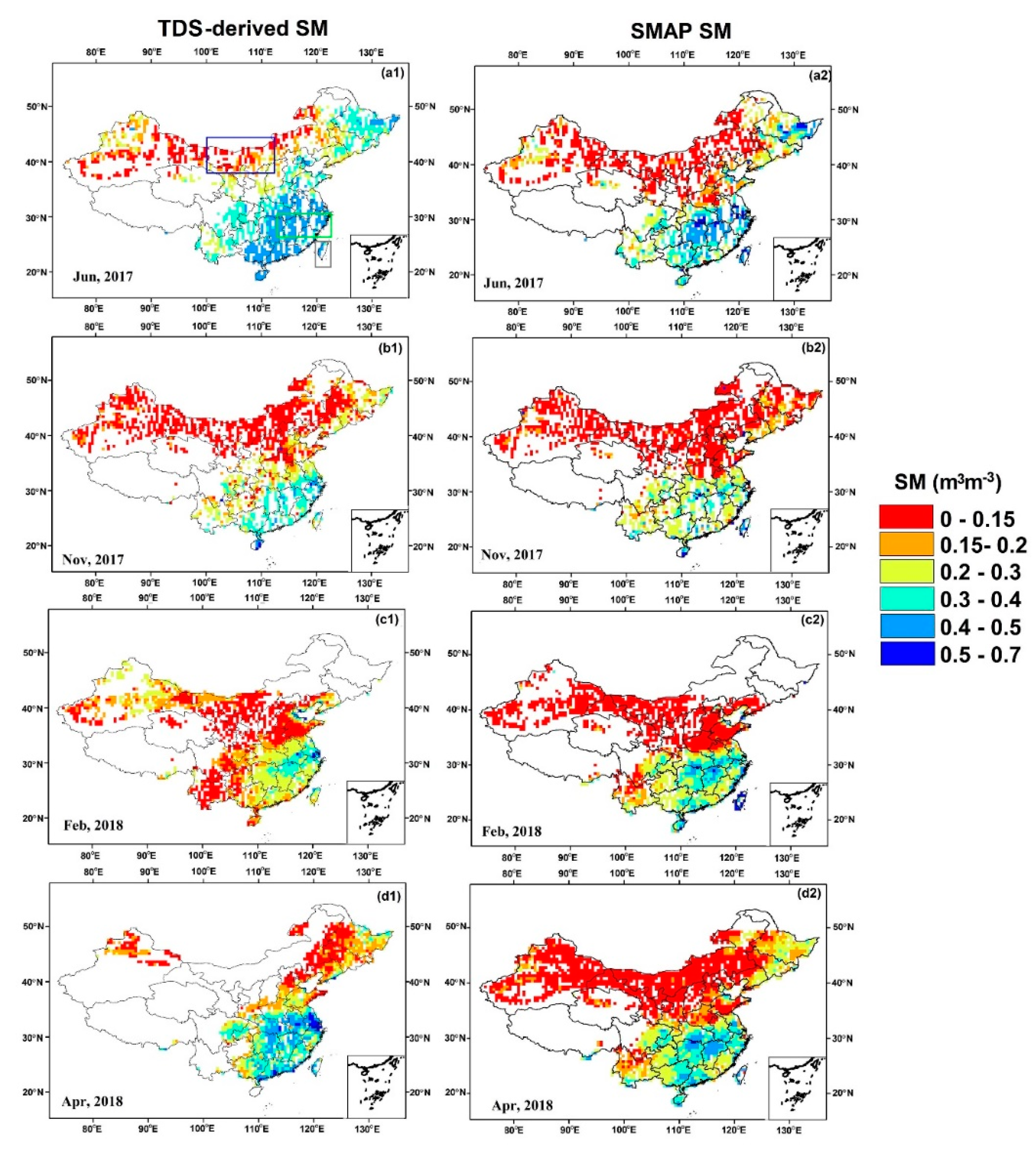
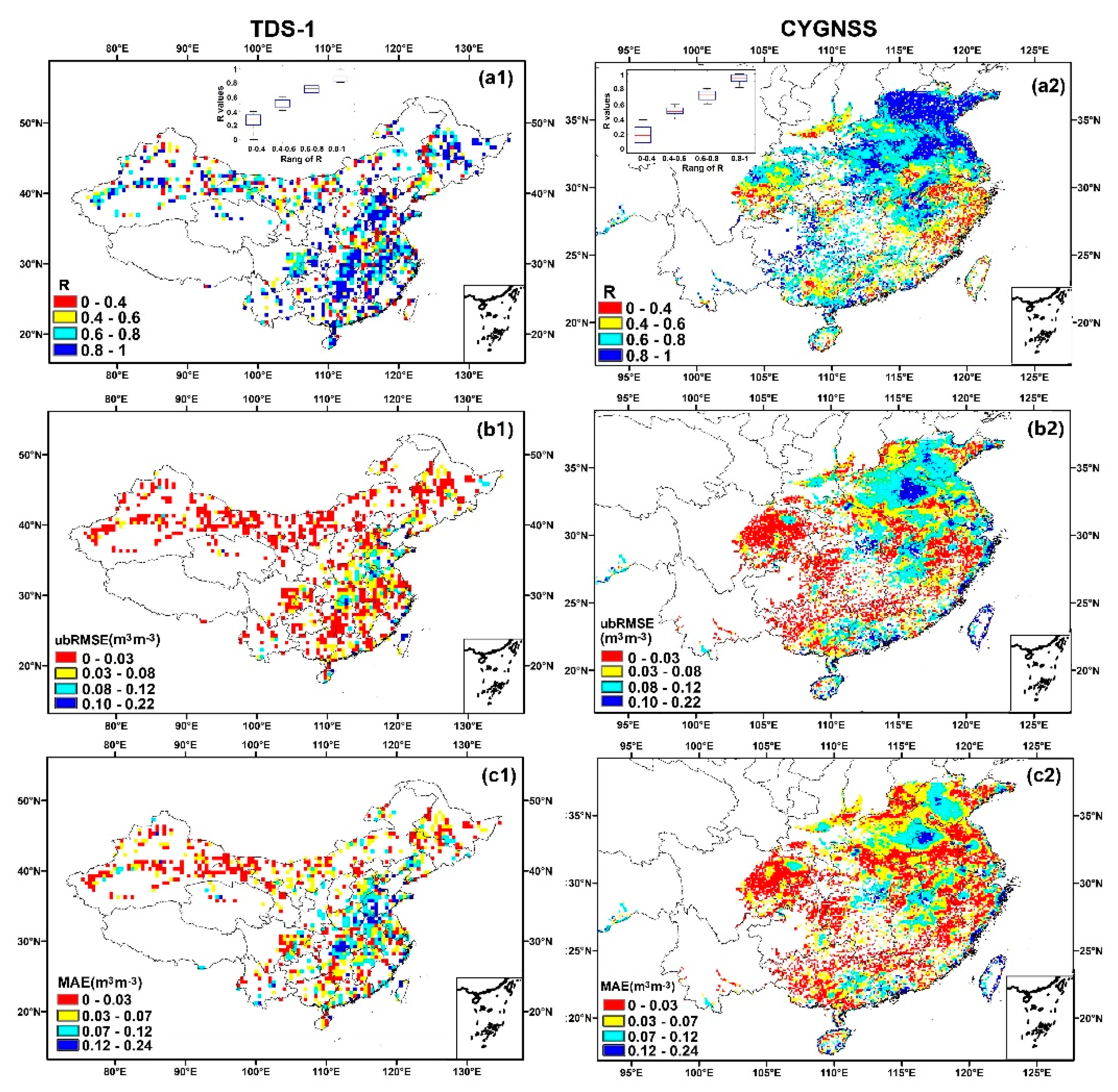
| This study | TDS-1, CYGNSS | Mainland China | (1) Compares and evaluates the performance of TDS-1 and CYGNSS for SM estimations on both daily and monthly scale; (2) Validates the GNSS-R derived SM by SMAP and dense (588) in situ networks over Mainland China | (1) TDS-1 and CYGNSS can produce SM data set with large scale and relatively high previse precision; (2) R = 0.676, ubRMSE = 0.060 m3m−3 for TDS-1 (vs. SMAP); R = 0.687, ubRMSE = 0.056 m3m−3 for TDS-1(vs. in situ) R = 0.798, and ubRMSE = 0.062 m3m−3 for CYGNSS (vs. SMAP) R = 0.724, ubRMSE = 0.053 m3m−3 for CYGNSS (vs. in situ) |
| Province | Numbers of Sites | Lat/Lon | Climate Condition | Land Cover |
|---|---|---|---|---|
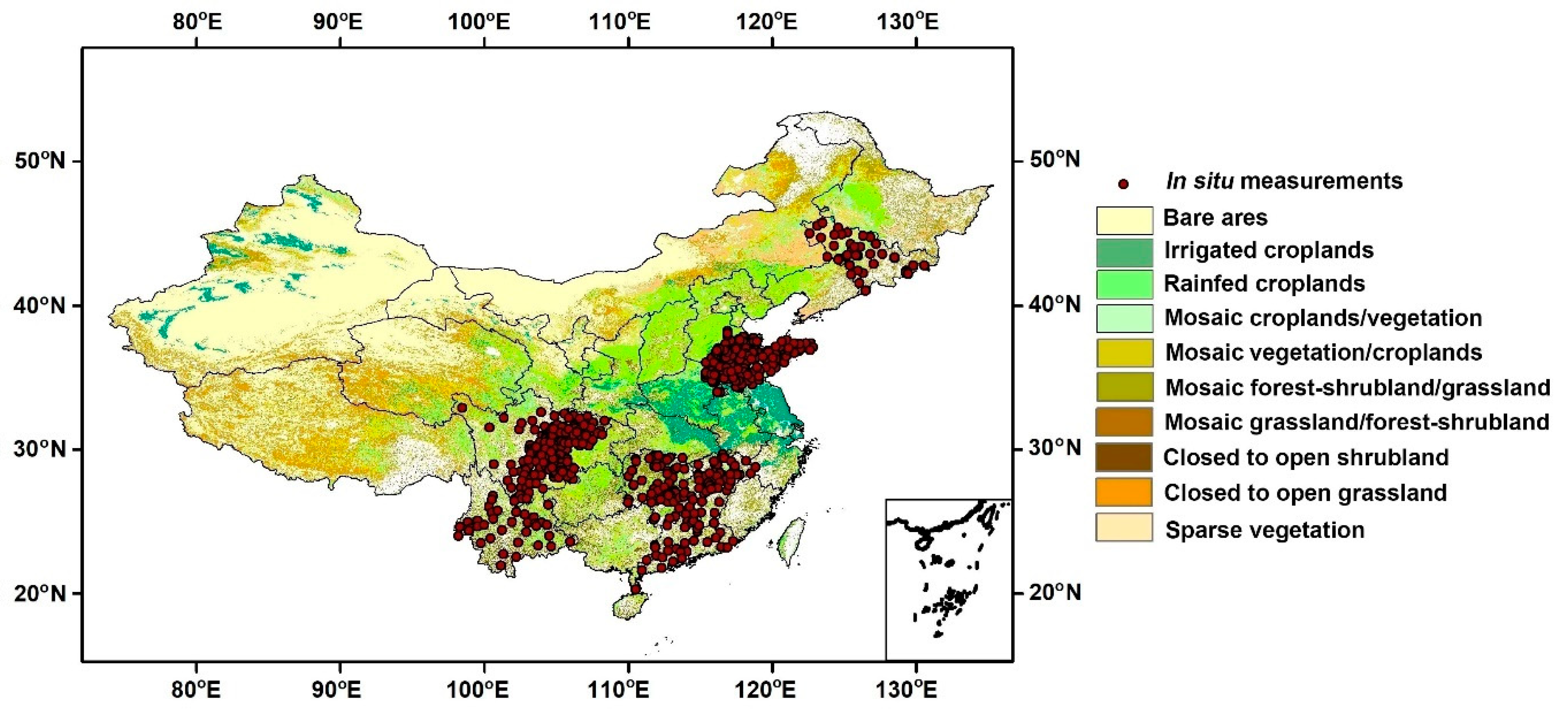
| Jilin | 48 | 41.1°~45.6° 122.2°~130.3° | Temperate continental monsoon | Irrigated croplands Rainfed croplands |
| Sichuan | 181 | 26.5°~33° 98.1°~108.3° | Subtropical monsoon | Irrigated croplands Rainfed croplands |
| Yunnan | 36 | 23.3°~27.4° 98.5°~104.3° | Tropical monsoon/Plateau mountain | Irrigated croplands Rainfed croplands Mosaic cropland/vegetation Mosaic vegetation/cropland Closed to open shrubland |
| Hunan | 60 | 25.1°~29.7° 90.6°~114° | Subtropical monsoon | Irrigated croplands Rainfed croplands Mosaic cropland/vegetation Mosaic vegetation/cropland Closed to open shrubland (<5 m) |
| Jiangxi | 52 | 24.5°~29.8° 113.5°~118.6° | Subtropical humid | Rainfed croplands Mosaic cropland/vegetation Mosaic vegetation/cropland Closed to open shrubland (<5 m) |
| Guangdong | 28 | 20.3°~25.1° 110.1°~117° | Subtropical monsoon | Rainfed croplands Mosaic cropland/vegetation Mosaic vegetation/cropland Closed to open shrubland (<5 m) |
| Shandong | 183 | 34°~38.4° 115.0°~122.6° | Temperate monsoon | Irrigated croplands Rainfed croplands Mosaic cropland/vegetation Mosaic vegetation/cropland |
| Model | Variables | R | RMSE (m3m−3) | MAE (m3m−3) |
|---|---|---|---|---|
| 1 | SR | 0.790 | 0.069 | 0.045 |
| 2 | SR, NDVI, VWC | 0.808 | 0.062 | 0.044 |
| 3 | SR, NDVI, VWC, Elev. | 0.828 | 0.065 | 0.063 |
| 4 | SR, NDVI, VWC, Preci. | 0.821 | 0.070 | 0.059 |
| 5 | SR, NDVI, VWC, Elev., Preci. | 0.814 | 0.067 | 0.056 |
| 6 | SR, NDVI, VWC, Preci., Elev., Slope, | 0.842 | 0.061 | 0.045 |
| 7 | SR, NDVI, VWC, Elev., Slope, Preci., Rough. | 0.871 | 0.057 | 0.041 |
| 8 | SR, NDVI, VWC, Elev., Slope, Preci., Rough., Noise | 0.856 | 0.061 | 0.049 |
| 9 | NDVI, VWC, Elev., Slope, Preci, Rough., Noise | 0.726 | 0.074 | 0.057 |
| 10 | NDVI, VWC, Elev., Slope, Preci., Rough. | 0.756 | 0.073 | 0.061 |
| Training Set | Testing Set | ||||
|---|---|---|---|---|---|
| R | RMSE (m3m−3) | R | RMSE (m3m−3) | ||
| Regression function | non-linear | 0.871 | 0.064 | 0.840 | 0.068 |
| linear | 0.762 | 0.073 | 0.748 | 0.075 | |
| Hidden layers | One | 0.755 | 0.069 | 0.755 | 0.080 |
| Two | 0.871 | 0.064 | 0.840 | 0.068 | |
| Three | 0.847 | 0.087 | 0.841 | 0.084 | |
| Four | 0.738 | 0.069 | 0.723 | 0.071 | |
| Activation function | logsig | 0.830 | 0.059 | 0.802 | 0.059 |
| tangent | 0.871 | 0.064 | 0.840 | 0.068 | |
| purelin | 0.841 | 0.083 | 0.832 | 0.081 | |
© 2020 by the authors. Licensee MDPI, Basel, Switzerland. This article is an open access article distributed under the terms and conditions of the Creative Commons Attribution (CC BY) license (http://creativecommons.org/licenses/by/4.0/).
Share and Cite
Yang, T.; Wan, W.; Sun, Z.; Liu, B.; Li, S.; Chen, X. Comprehensive Evaluation of Using TechDemoSat-1 and CYGNSS Data to Estimate Soil Moisture over Mainland China. Remote Sens. 2020, 12, 1699. https://doi.org/10.3390/rs12111699
Yang T, Wan W, Sun Z, Liu B, Li S, Chen X. Comprehensive Evaluation of Using TechDemoSat-1 and CYGNSS Data to Estimate Soil Moisture over Mainland China. Remote Sensing. 2020; 12(11):1699. https://doi.org/10.3390/rs12111699
Chicago/Turabian StyleYang, Ting, Wei Wan, Zhigang Sun, Baojian Liu, Sen Li, and Xiuwan Chen. 2020. "Comprehensive Evaluation of Using TechDemoSat-1 and CYGNSS Data to Estimate Soil Moisture over Mainland China" Remote Sensing 12, no. 11: 1699. https://doi.org/10.3390/rs12111699
APA StyleYang, T., Wan, W., Sun, Z., Liu, B., Li, S., & Chen, X. (2020). Comprehensive Evaluation of Using TechDemoSat-1 and CYGNSS Data to Estimate Soil Moisture over Mainland China. Remote Sensing, 12(11), 1699. https://doi.org/10.3390/rs12111699


