Evolving Instability of the Scar Inlet Ice Shelf based on Sequential Landsat Images Spanning 2005–2018

Abstract
1. Introduction
2. Data and Methods
2.1. Landsat Imagery and Grounding Line Products
2.2. Ice Flow Velocity Mapping
2.3. Ice Shelf Front Positioning
2.4. Ice Surface Features Delineating
2.5. Mean austral Summer Temperature and Fast Ice Monitoring
3. Results
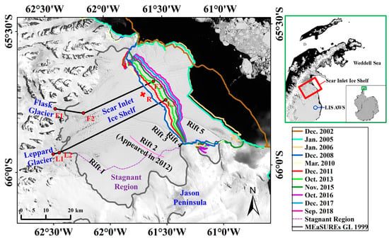
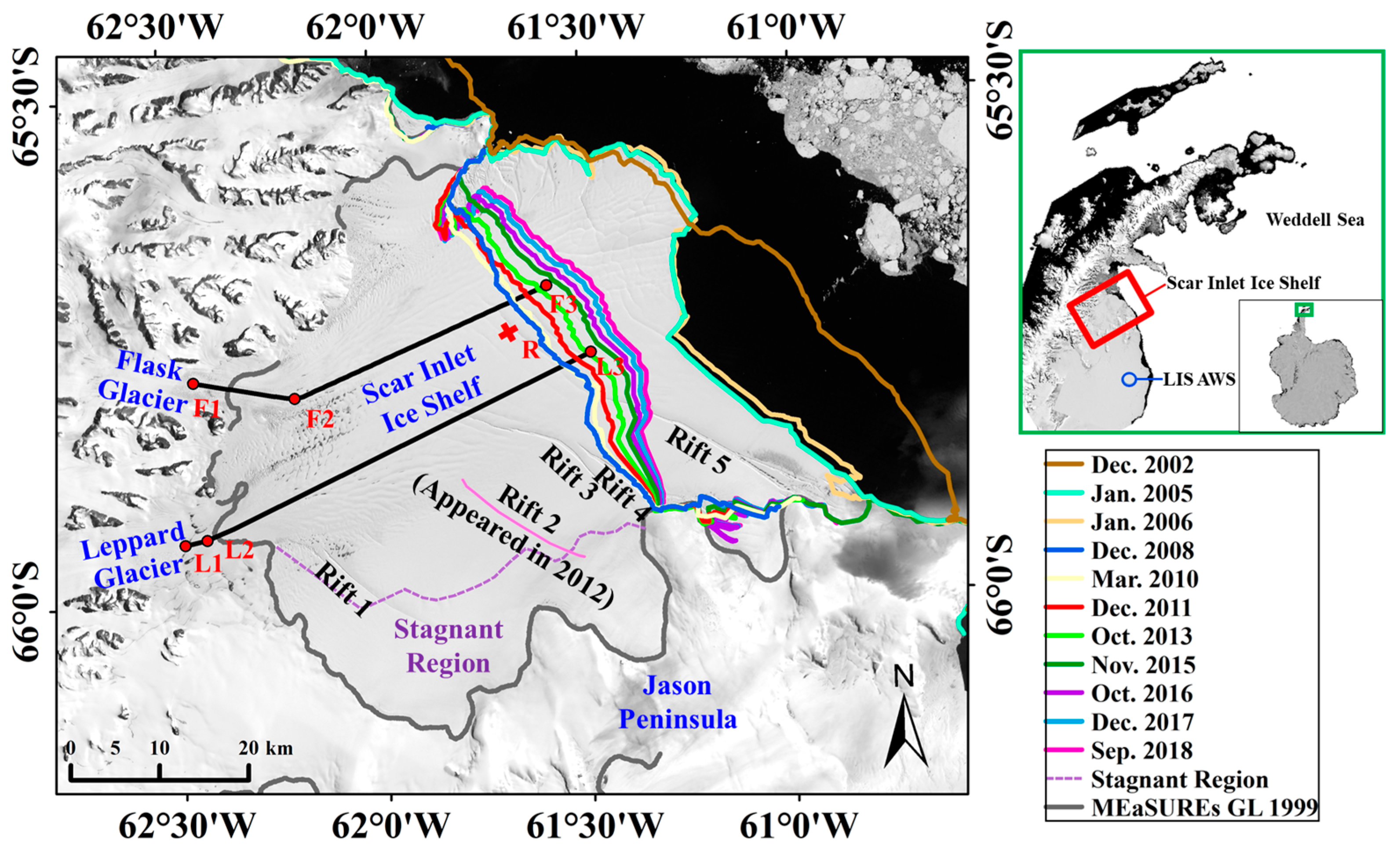
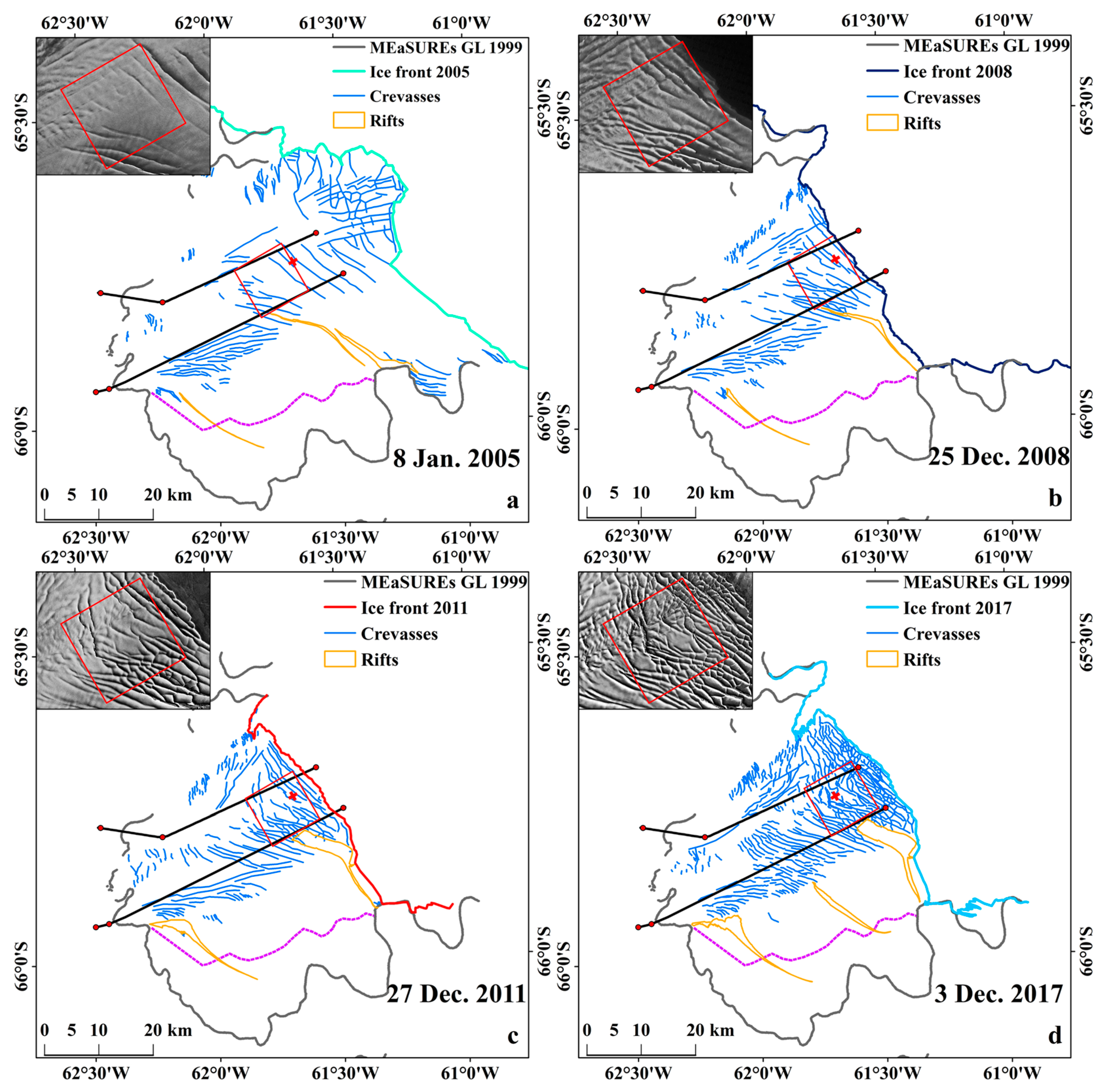
3.1. Changes in the Scar Inlet Ice Shelf Front Positions
3.2. Changes in the Scar Inlet Ice Shelf Surface Features
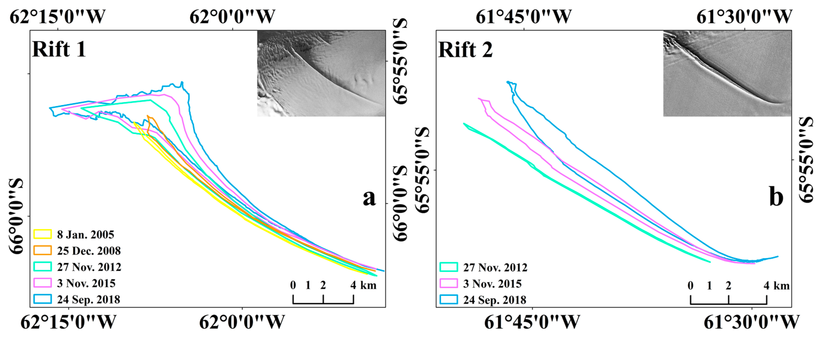
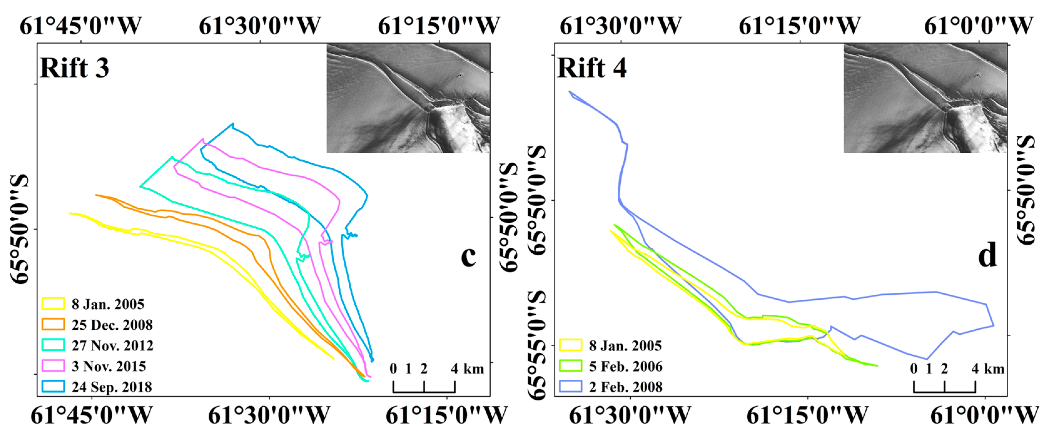
3.2.1. Rifts
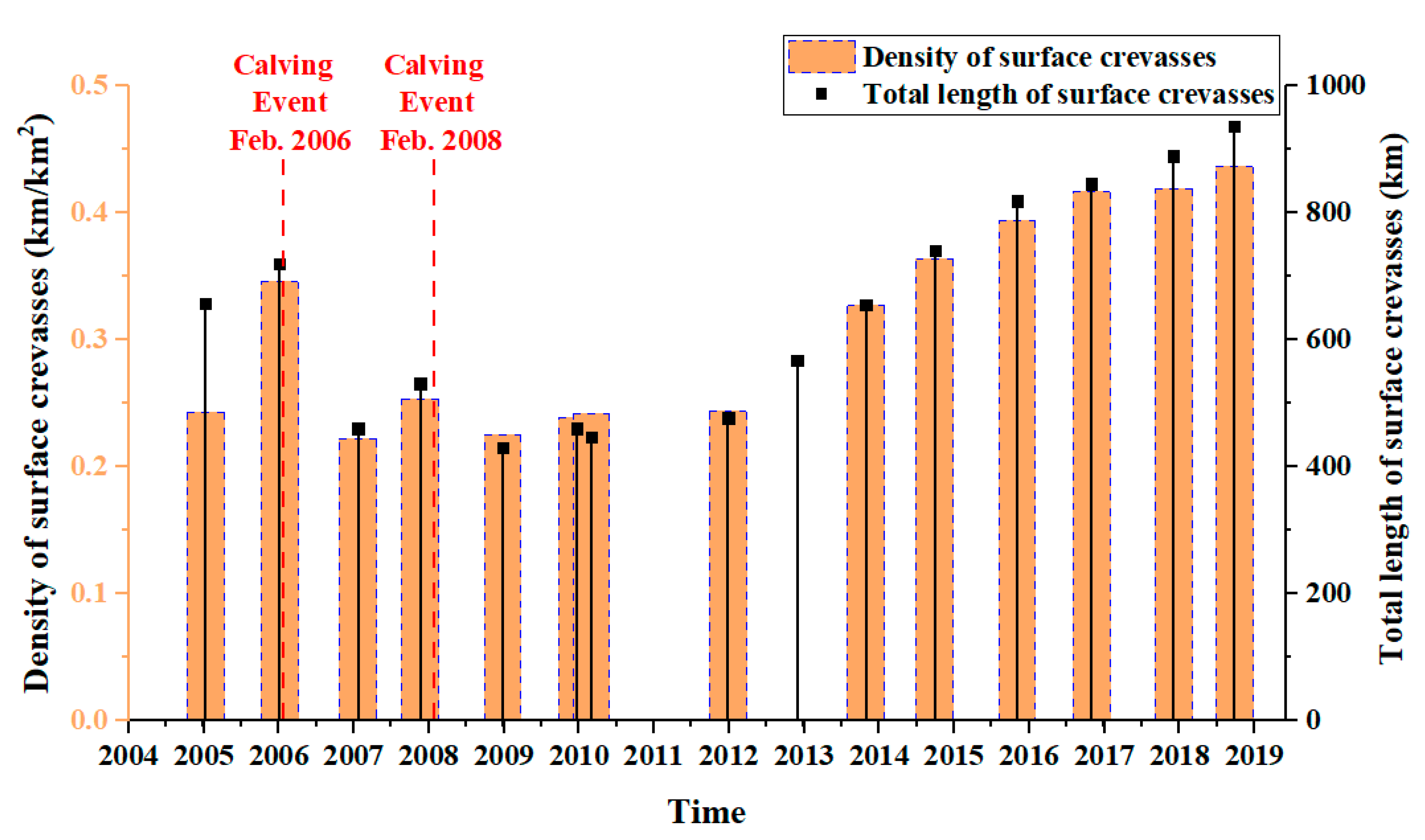
3.2.2. Crevasses
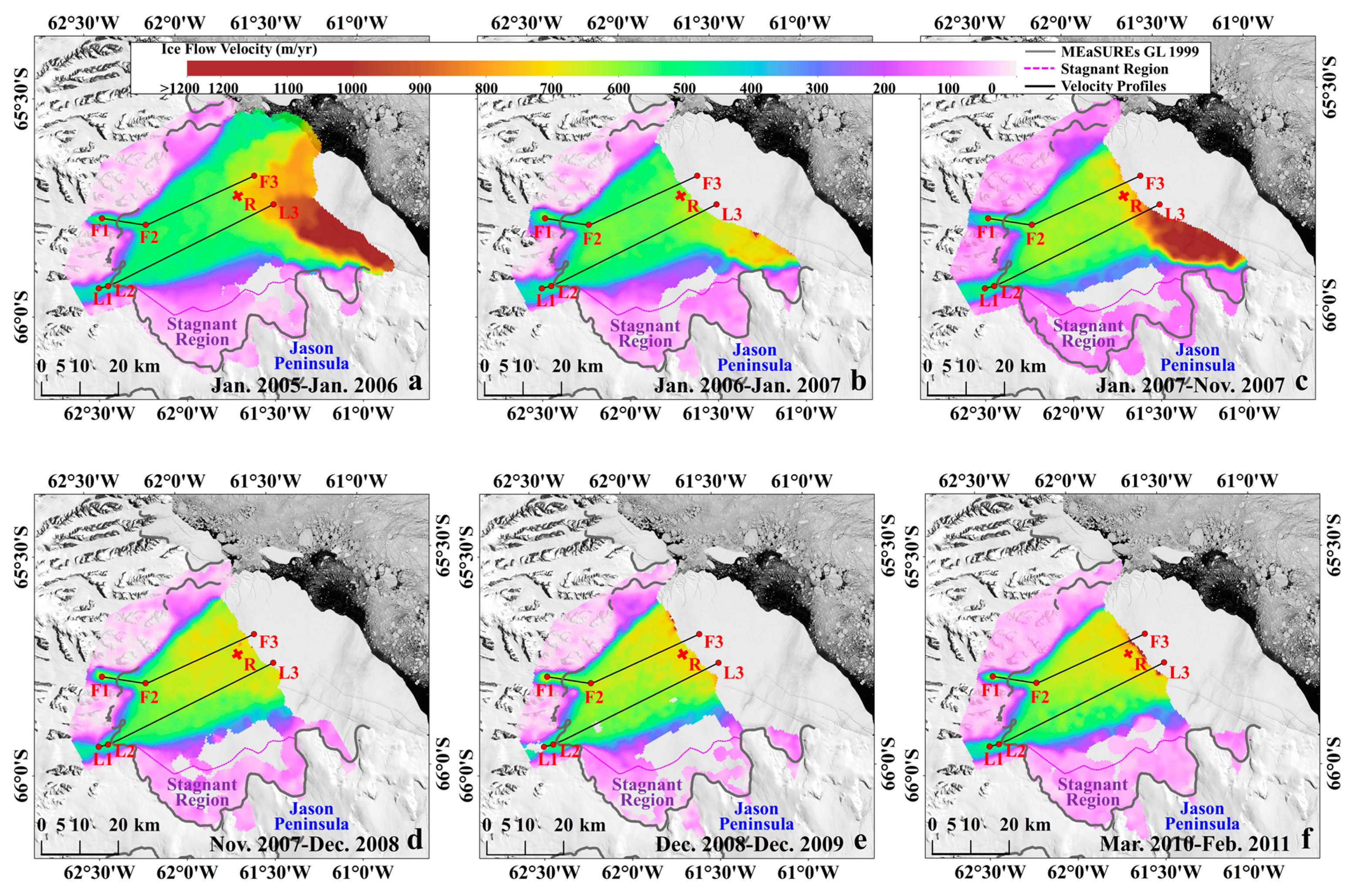
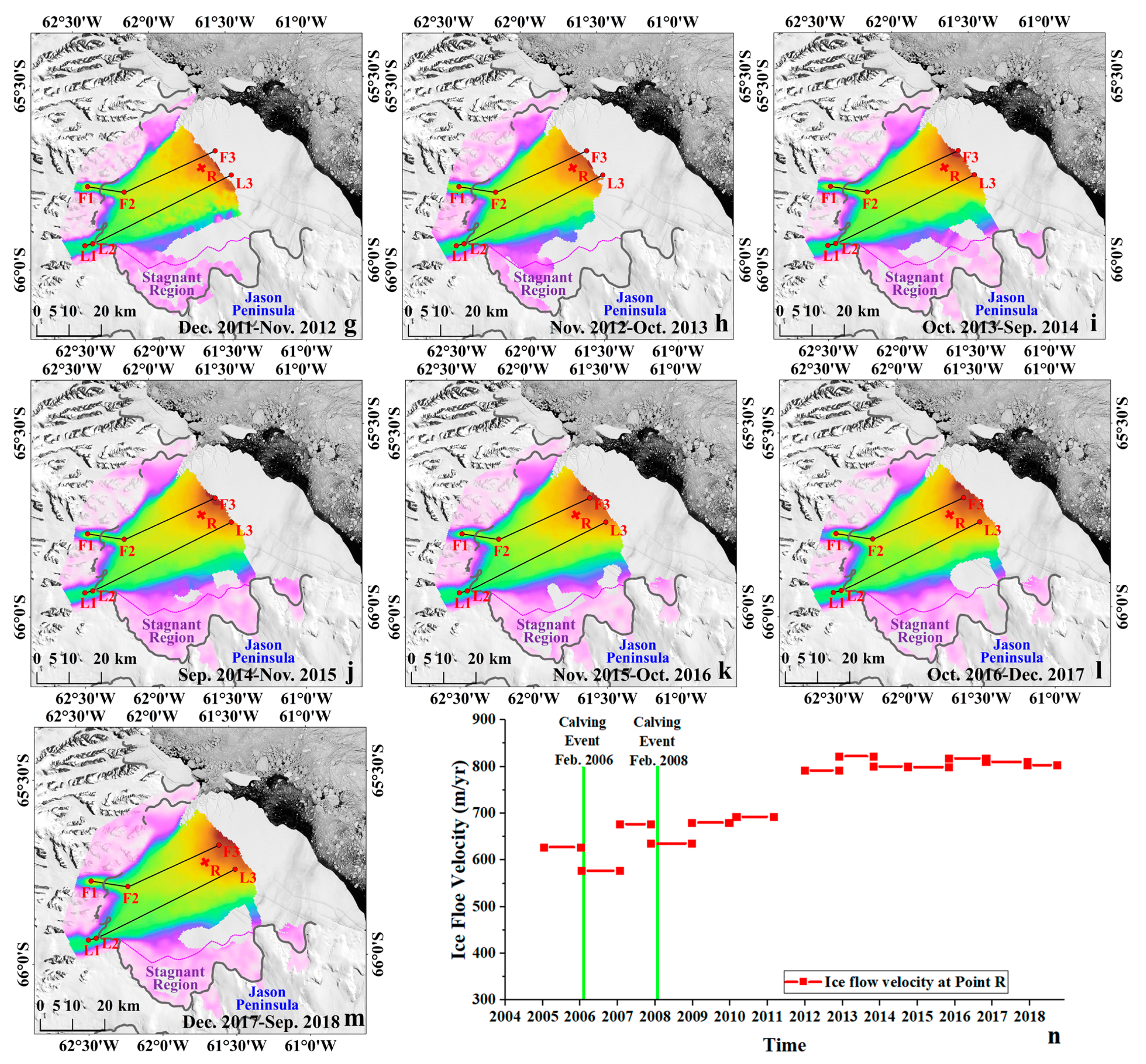
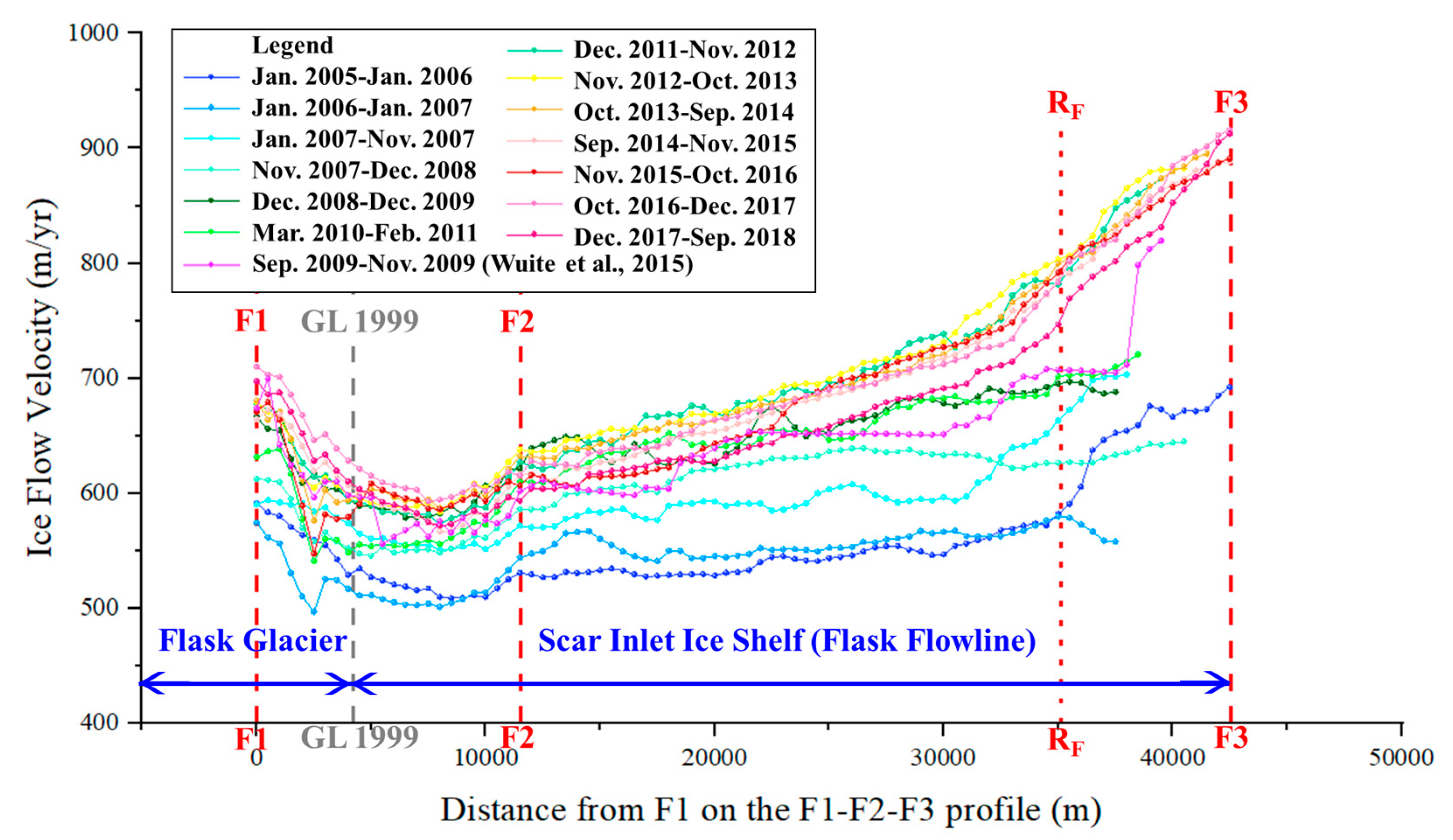
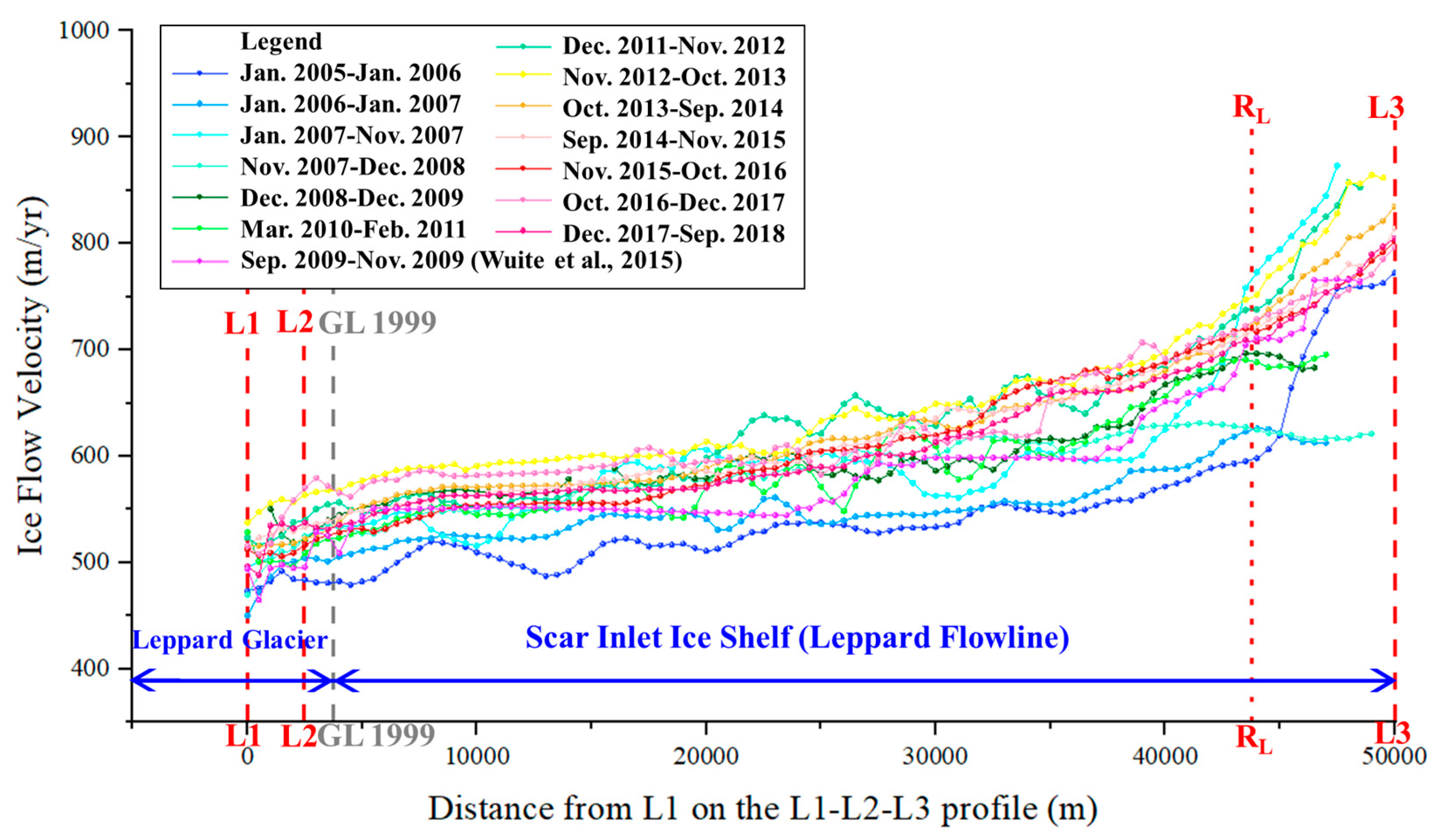
3.3. Changes in the Scar Inlet Ice Shelf Ice Flow Velocities
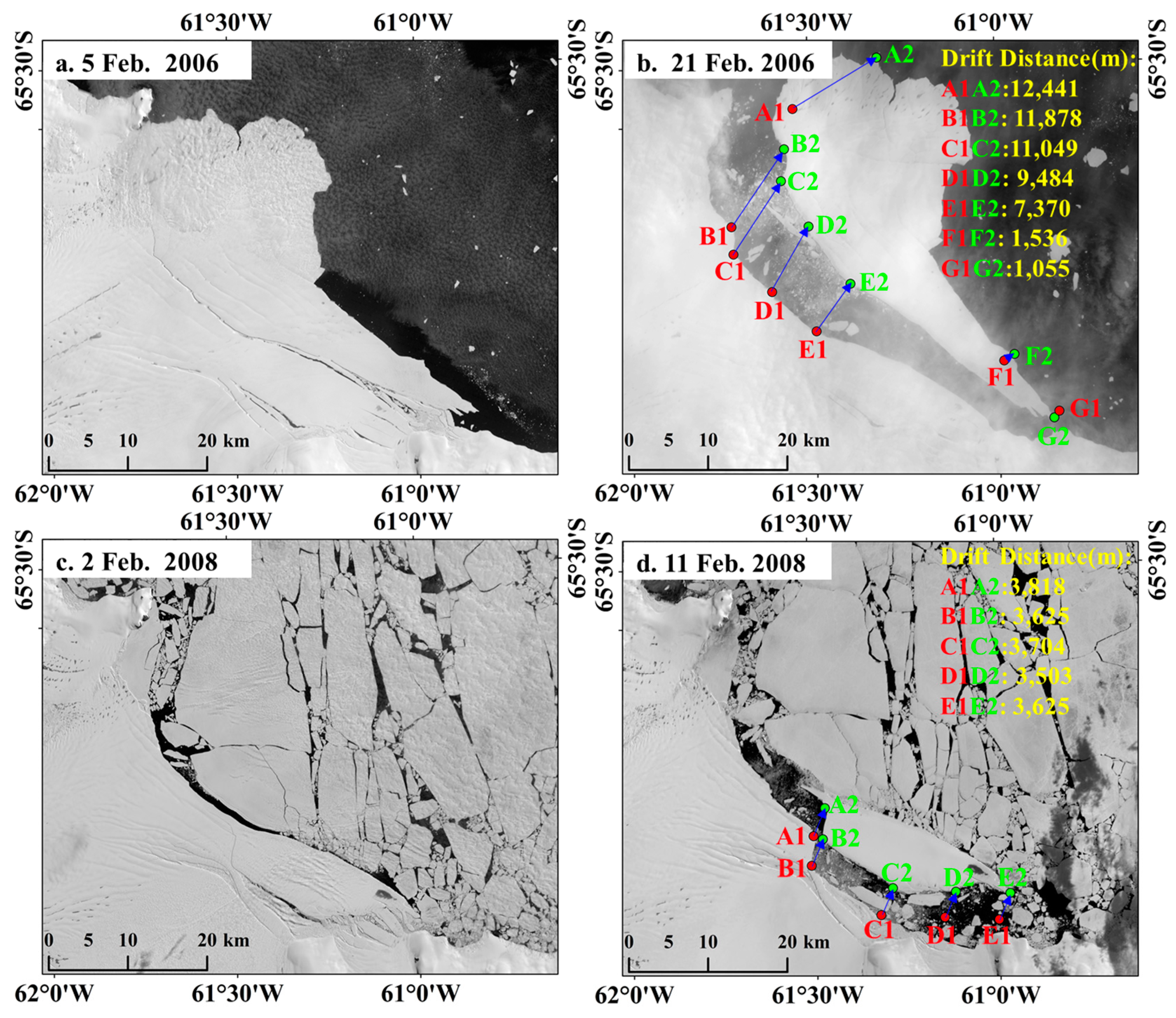
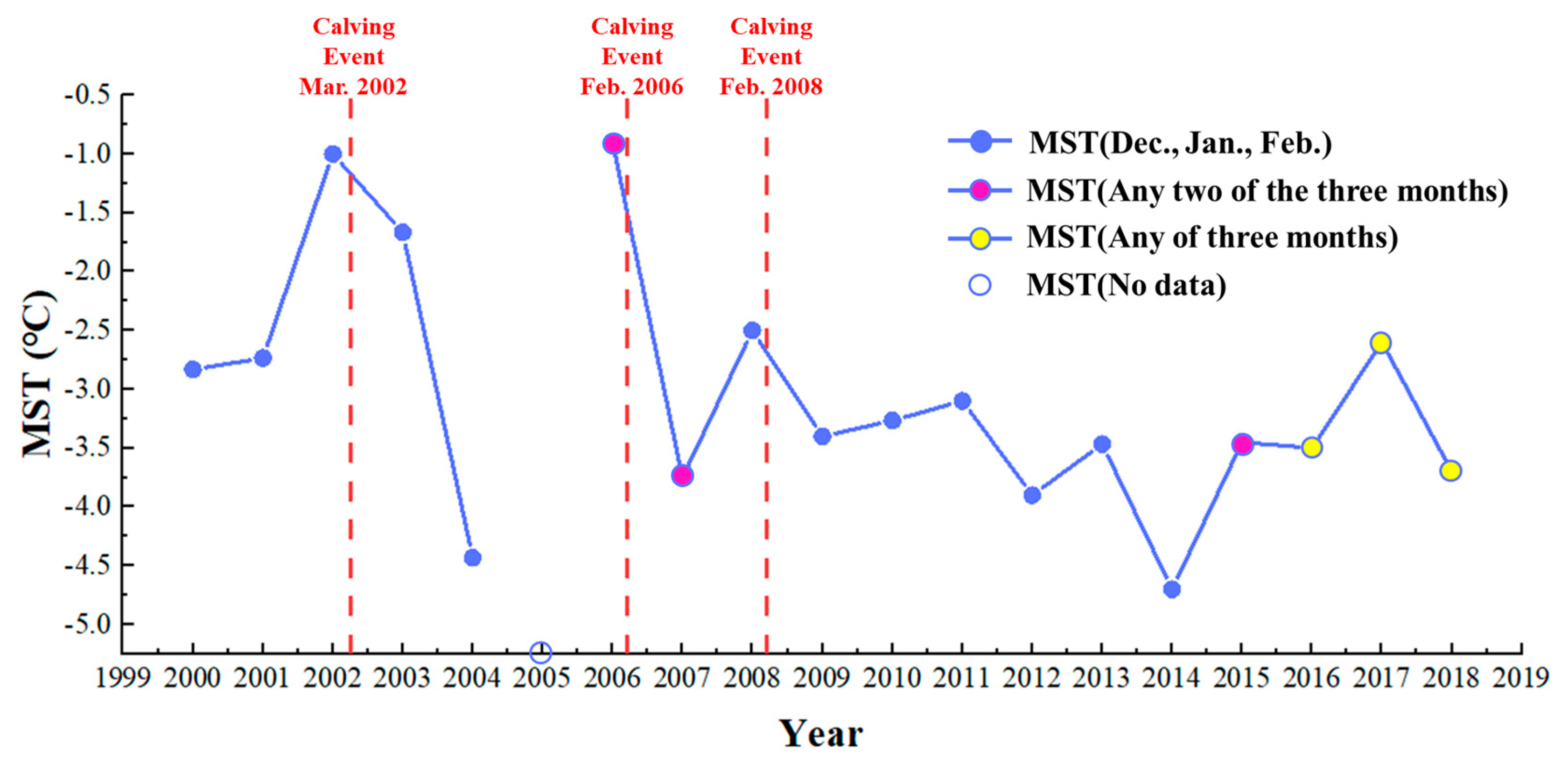
3.4. Major Calving Events of the Scar Inlet Ice Shelf
4. Discussion
5. Conclusions
Supplementary Materials
Author Contributions
Funding
Acknowledgments
Conflicts of Interest
References
- Rack, W.; Rott, H. Pattern of retreat and disintegration of the Larsen B ice shelf, Antarctic Peninsula. Ann. Glaciol. 2004, 39, 505–510. [Google Scholar] [CrossRef]
- Skvarca, P.; Angelis, H.D.; Zakrajsek, A.F. Climatic conditions, mass balance and dynamics of Larsen B ice shelf, Antarctic Peninsula, prior to collapse. Ann. Glaciol. 2004, 39, 557–562. [Google Scholar] [CrossRef]
- Domack, E.; Duran, D.; Leventer, A.; Ishman, S.; Doane, S.; McCallum, S.; Amblas, D.; Ring, J.; Gilbert, R.; Prentice, M. Stability of the Larsen B ice shelf on the Antarctic Peninsula during the Holocene epoch. Nature 2005, 436, 681–685. [Google Scholar] [CrossRef]
- Cook, A.J.; Vaughan, D.G. Overview of areal changes of the ice shelves on the Antarctic Peninsula over the past 50 years. Cryosphere 2010, 4, 77–98. [Google Scholar] [CrossRef]
- Shepherd, A.; Wingham, D.; Wallis, D.; Giles, K.; Laxon, S.; Sundal, A.V. Recent loss of floating ice and the consequent sea level contribution. Geophys. Res. Lett. 2010, 37. [Google Scholar] [CrossRef]
- Chen, J.; Ke, C.Q.; Zhou, X. Variations in the extent and elevation of the Larsen A and B ice shelves, Antarctica, derived from multiple datasets. J. Appl. Remote Sens. 2018, 12, 046019. [Google Scholar] [CrossRef]
- Scambos, T.A.; Bohlander, J.A.; Shuman, C.A.; Skvarca, P. Glacier acceleration and thinning after ice shelf collapse in the Larsen B embayment, Antarctica. Geophys. Res. Lett. 2004, 31. [Google Scholar] [CrossRef]
- Rignot, E. Accelerated ice discharge from the Antarctic Peninsula following the collapse of Larsen B ice shelf. Geophys. Res. Lett. 2004, 31. [Google Scholar] [CrossRef]
- Wang, S.; Liu, H.; Yu, B.; Zhou, G.; Cheng, X. Revealing the early ice flow patterns with historical declassified intelligence satellite photographs back to 1960s. Geophys. Res. Lett. 2016, 43, 5758–5767. [Google Scholar] [CrossRef]
- Berthier, E.; Scambos, T.A.; Shuman, C.A. Mass loss of Larsen B tributary glaciers (Antarctic Peninsula) unabated since 2002. Geophys. Res. Lett. 2012, 39, 342–343. [Google Scholar] [CrossRef]
- Leeson, A.A.; Van Wessem, J.M.; Ligtenberg, S.R.M.; Shepherd, A.; Van Den Broeke, M.R.; Killick, R.; Skvarca, P.; Marinsek, S.; Colwell, S. Regional climate of the Larsen B embayment 1980–2014. J. Glaciol. 2017, 63, 683–690. [Google Scholar] [CrossRef]
- Han, H.; Lee, S.; Kim, J.-I.; Kim, S.H.; Kim, H.-c. Changes in a giant iceberg created from the collapse of the larsen c ice shelf, Antarctic Peninsula, derived from Sentinel-1 and CryoSat-2 data. Remote Sens. 2019, 11, 404. [Google Scholar] [CrossRef]
- Shuman, C.; Scambos, T.; Berthier, E. Ice loss processes in the Seal Nunataks ice shelf region from satellite altimetry and imagery. Ann. Glaciol. 2016, 57, 94–104. [Google Scholar] [CrossRef][Green Version]
- Turner, J.; Lu, H.; White, I.; King, J.C.; Phillips, T.; Hosking, J.S.; Bracegirdle, T.J.; Marshall, G.J.; Mulvaney, R.; Deb, P. Absence of 21st century warming on Antarctic Peninsula consistent with natural variability. Nature 2016, 535, 411–415. [Google Scholar] [CrossRef]
- Oliva, M.; Navarro, F.; Hrbáček, F.; Hernández, A.; Nývlt, D.; Pereira, P.; Ruiz-Fernández, J.; Trigo, R. Recent regional climate cooling on the Antarctic Peninsula and associated impacts on the cryosphere. Sci. Total Environ. 2017, 580, 210–223. [Google Scholar] [CrossRef]
- Shuman, C.A.; Berthier, E.; Scambos, T.A. 2001–2009 elevation and mass losses in the Larsen A and B embayments, Antarctic Peninsula. J. Glaciol. 2011, 57, 737–754. [Google Scholar] [CrossRef][Green Version]
- Rott, H.; Müller, F.; Nagler, T.; Floricioiu, D. The imbalance of glaciers after disintegration of Larsen-B ice shelf, Antarctic Peninsula. Cryosphere 2011, 5, 125–134. [Google Scholar] [CrossRef]
- Farinotti, D.; Corr, H.; Gudmundsson, G.H. The ice thickness distribution of Flask glacier, Antarctic Peninsula, determined by combining Radio-Echo Soundings, surface velocity data and flow modelling. Ann. Glaciol. 2013, 54, 18–24. [Google Scholar] [CrossRef]
- Farinotti, D.; King, E.C.; Albrecht, A.; Huss, M.; Gudmundsson, G.H. The bedrock topography of Starbuck glacier, Antarctic Peninsula, as determined by Radio-Echo Soundings and flow modeling. Ann. Glaciol. 2014, 55, 22–28. [Google Scholar] [CrossRef]
- Khazendar, A.; Borstad, C.P.; Scheuchl, B.; Rignot, E.; Seroussi, H. The evolving instability of the remnant Larsen B ice shelf and its tributary glaciers. Earth Planet. Sci. Lett. 2015, 419, 199–210. [Google Scholar] [CrossRef]
- Wuite, J.; Rott, H.; Hetzenecker, M.; Floricioiu, D.; De Rydt, J.; Gudmundsson, G.H.; Nagler, T.; Kern, M. Evolution of surface velocities and ice discharge of Larsen B outlet glaciers from 1995 to 2013. Cryosphere 2015, 9, 957–969. [Google Scholar] [CrossRef]
- Baumhoer, C.; Dietz, A.; Dech, S.; Kuenzer, C. Remote sensing of antarctic glacier and ice-shelf front dynamics—A review. Remote Sens. 2018, 10, 1445. [Google Scholar] [CrossRef]
- De Rydt, J.; Gudmundsson, G.H.; Rott, H.; Bamber, J.L. Modeling the instantaneous response of glaciers after the collapse of the Larsen B ice shelf. Geophys. Res. Lett. 2015, 42, 5355–5363. [Google Scholar] [CrossRef]
- Rignot, E.; Mouginot, J.; Scheuchl, B. Ice flow of the antarctic ice sheet. Science 2011, 333, 1427–1430. [Google Scholar] [CrossRef]
- Mouginot, J.; Scheuchl, B.; Rignot, E. Mapping of ice motion in Antarctica using Synthetic-Aperture Radar data. Remote Sens. 2012, 4, 2753–2767. [Google Scholar] [CrossRef]
- Teng, L.; Yan, L.; Tian, L.; Fengming, H.; Zhuoqi, C.; Xiao, C. Antarctic surface ice velocity retrieval from MODIS-based mosaic of Antarctica (MOA). Remote Sens. 2018, 10, 1045. [Google Scholar] [CrossRef]
- Ai, S.; Ding, X.; An, J.; Lin, G.; Wang, Z.; Yan, M. Discovery of the fastest ice flow along the central flow line of Austre Lovénbreen, a poly-thermal valley glacier in Svalbard. Remote Sens. 2019, 11, 1488. [Google Scholar] [CrossRef]
- Fricker, H.A.; Padman, L. Thirty years of elevation change on Antarctic Peninsula ice shelves from multimission satellite radar altimetry. J. Geophys. Res. Ocean. 2012, 117. [Google Scholar] [CrossRef]
- Rott, H.; Jaber, W.A.; Wuite, J.; Scheiblauer, S.; Floricioiu, D.; van Wessem, J.M.; Nagler, T.; Miranda, N.; van den Broeke, M.R. Changing pattern of ice flow and mass balance for glaciers discharging into the Larsen A and B embayments, Antarctic Peninsula, 2011 to 2016. Cryosphere 2018, 12, 1273–1291. [Google Scholar] [CrossRef]
- Borstad, C.; Khazendar, A.; Scheuchl, B.; Morlighem, M.; Larour, E.; Rignot, E. A constitutive framework for predicting weakening and reduced buttressing of ice shelves based on observations of the progressive deterioration of the remnant Larsen B ice shelf. Geophys. Res. Lett. 2016, 43, 2027–2035. [Google Scholar] [CrossRef]
- Massom, R.A.; Scambos, T.A.; Bennetts, L.G.; Reid, P.; Squire, V.A.; Stammerjohn, S.E. Antarctic ice shelf disintegration triggered by sea ice loss and ocean swell. Nature 2018, 558, 383. [Google Scholar] [CrossRef]
- Warner, R.C.; Roberts, J.L. Pine Island Glacier (Antarctica) velocities from Landsat7 images between 2001 and 2011: Fft-based image correlation for images with data gaps. J. Glaciol. 2013, 59, 571–582. [Google Scholar] [CrossRef]
- Schowengerdt, R.A. Remote Sensing: Models and Methods for Image Processing; Elsevier: Amsterdam, The Netherlands, 2006. [Google Scholar]
- Scambos, T.; Haran, T.; Fahnestock, M.; Painter, T.; Bohlander, J. MODIS-based mosaic of Antarctica (MOA) data sets: Continent-wide surface morphology and snow grain size. Remote Sens. Environ. 2007, 111, 242–257. [Google Scholar] [CrossRef]
- Bindschadler, R.; Choi, H.; Wichlacz, A.; Bingham, B.; Bohlander, J.; Brunt, K.; Corr, H.; Drews, R.; Fricker, H.; Hall, M. Getting around Antarctica: New high-resolution mappings of the grounded and freely-floating boundaries of the Antarctic ice sheet created for the International Polar Year. Cryosphere 2011, 5, 569–588. [Google Scholar] [CrossRef]
- Brunt, K.; Fricker, H.; Padman, L.; O’Neel, S. ICESat-derived grounding zone for Antarctic ice shelves, U.S. Antarctic Program (USAP) Data Center. Digit. Media 2010. [Google Scholar] [CrossRef]
- Rignot, E.; Mouginot, J.; Scheuchl, B. Antarctic grounding line mapping from differential satellite radar interferometry. Geophys. Res. Lett. 2011, 38. [Google Scholar] [CrossRef]
- Depoorter, M.; Bamber, J.; Griggs, J.; Lenaerts, J.; Ligtenberg, S.; van den Broeke, M.; Moholdt, G. Synthesized grounding line and ice shelf mask for Antarctica. PANGAEA 2013. [Google Scholar] [CrossRef]
- Scambos, T.A.; Dutkiewicz, M.J.; Wilson, J.C.; Bindschadler, R.A. Application of image cross-correlation to the measurement of glacier velocity using satellite image data. Remote Sens. Environ. 1992, 42, 177–186. [Google Scholar] [CrossRef]
- Fahnestock, M.; Scambos, T.; Moon, T.; Gardner, A.; Haran, T.; Klinger, M. Rapid large-area mapping of ice flow using Landsat 8. Remote Sens. Environ. 2016, 185, 84–94. [Google Scholar] [CrossRef]
- Haug, T.; Kääb, A.; Skvarca, P. Monitoring ice shelf velocities from repeat MODIS and Landsat data—A method study on the Larsen C ice shelf, Antarctic Peninsula, and 10 other ice shelves around Antarctica. Cryosphere 2010, 4, 161–178. [Google Scholar] [CrossRef]
- Chen, J.; Ke, C.; Zhou, X.; Shao, Z.; Li, L. Surface velocity estimations of ice shelves in the northern Antarctic Peninsula derived from MODIS data. J. Geogr. Sci. 2016, 26, 243–256. [Google Scholar] [CrossRef]
- Mouginot, J.; Rignot, E.; Scheuchl, B. Sustained increase in ice discharge from the Amundsen sea embayment, west Antarctica, from 1973 to 2013. Geophys. Res. Lett. 2014, 41, 1576–1584. [Google Scholar] [CrossRef]
- Hall, D.K.; Bayr, K.J.; Schöner, W.; Bindschadler, R.A.; Chien, J.Y.L. Consideration of the errors inherent in mapping historical glacier positions in Austria from the ground and space (1893–2001). Remote Sens. Environ. 2003, 86, 566–577. [Google Scholar] [CrossRef]
- Ye, Q.; Kang, S.; Chen, F.; Wang, J. Monitoring glacier variations on Geladandong mountain, central Tibetan Plateau, from 1969 to 2002 using Remote-Sensing and GIS technologies. J. Glaciol. 2006, 52, 537–545. [Google Scholar] [CrossRef]
- Colgan, W.; Rajaram, H.; Abdalati, W.; McCutchan, C.; Mottram, R.; Moussavi, M.S.; Grigsby, S. Glacier crevasses: Observations, models, and mass balance implications. Rev. Geophys. 2016, 54, 119–161. [Google Scholar] [CrossRef]
- Borstad, C.; McGrath, D.; Pope, A. Fracture propagation and stability of ice shelves governed by ice shelf heterogeneity. Geophys. Res. Lett. 2017, 44, 4186–4194. [Google Scholar] [CrossRef]
- Rist, M.A.; Sammonds, P.R.; Oerter, H.; Doake, C.S.M. Fracture of Antarctic shelf ice. J. Geophys. Res. Solid Earth 2002, 107, ECV 2-1–ECV 2-13. [Google Scholar] [CrossRef]
- Larour, E.; Rignot, E.; Aubry, D. Processes involved in the propagation of rifts near Hemmen ice rise, Ronne ice shelf, Antarctica. J. Glaciol. 2004, 50, 329–341. [Google Scholar] [CrossRef][Green Version]
- Glasser, N.F.; Scambos, T.A. A structural glaciological analysis of the 2002 Larsen B ice-shelf collapse. J. Glaciol. 2008, 54, 3–16. [Google Scholar] [CrossRef]
- Wesche, C.; Jansen, D.; Dierking, W. Calving fronts of Antarctica: Mapping and classification. Remote Sens. 2013, 5, 6305–6322. [Google Scholar] [CrossRef]
- Glasser, N.F.; Kulessa, B.; Luckman, A.; Jansen, D.; King, E.C.; Sammonds, P.R.; Scambos, T.A.; Jezek, K.C. Surface structure and stability of the Larsen C ice shelf, Antarctic Peninsula. J. Glaciol. 2009, 55, 400–410. [Google Scholar] [CrossRef]
- Moon, T.; Joughin, I. Changes in ice front position on Greenland‘s outlet glaciers from 1992 to 2007. J. Geophys. Res. Earth Surf. 2008, 113. [Google Scholar] [CrossRef]
- Scambos, T.; Ross, R.; Bauer, R.; Yermolin, Y.; Skvarca, P.; Long, D.; Bohlander, J.; Haran, T. Calving and ice-shelf break-up processes investigated by proxy: Antarctic tabular iceberg evolution during northward drift. J. Glaciol. 2008, 54, 579–591. [Google Scholar] [CrossRef]
- Vieli, A.; Payne, A.J.; Shepherd, A.; Du, Z. Causes of pre-collapse changes of the Larsen B ice shelf: Numerical modelling and assimilation of satellite observations. Earth Planet. Sci. Lett. 2007, 259, 297–306. [Google Scholar] [CrossRef]


| ID | Satellite | Path and Raw | Acquisition Date | Ice Flow Velocity Mapping | Ice Shelf Front Positioning | Rifts Delineation | Crevasses Delineation |
|---|---|---|---|---|---|---|---|
| 1 | Landsat 7 ETM+ | 217 and 106 | 8 Jan. 2005 | √ | √ | √ | √ |
| 2 | 216 and 106 | 4 Jan. 2006 | √ | √ | √ | √ | |
| 3 | 217 and 106 | 11 Jan. 2006 | √ | - | - | - | |
| 4 | 216 and 106 | 5 Feb. 2006 | - | - | √ | - | |
| 5 | 218 and 106 | 21 Jan. 2007 | √ | √ | √ | √ | |
| 6 | 218 and 106 | 21 Nov. 2007 | √ | - | - | - | |
| 7 | 217 and 106 | 2 Feb. 2008 | - | - | √ | - | |
| 8 | 218 and 106 | 25 Dec. 2008 | √ | √ | √ | √ | |
| 9 | 217 and 106 | 21 Dec. 2009 | √ | √ | √ | √ | |
| 10 | 218 and 106 | 2 Mar. 2010 | √ | √ | √ | √ | |
| 11 | 217 and 106 | 26 Feb. 2011 | √ | √ | √ | √ | |
| 12 | 217 and 106 | 27 Dec. 2011 | √ | √ | √ | √ | |
| 13 | 217 and 106 | 27 Nov.2012 | √ | - | √ | √ | |
| 14 | Landsat 8 OLI | 218 and 106 | 28 Oct. 2013 | √ | √ | √ | √ |
| 15 | 218 and 106 | 29 Sep. 2014 | √ | √ | √ | √ | |
| 16 | 218 and 106 | 3 Nov. 2015 | √ | √ | √ | √ | |
| 17 | 217 and 106 | 29 Oct. 2016 | √ | √ | √ | √ | |
| 18 | 217 and 106 | 3 Dec. 2017 | √ | √ | √ | √ | |
| 19 | 218 and 106 | 24 Sep. 2018 | √ | √ | √ | √ |
| Image 1 | Image 2 | Interval (d) | Image Co-registration Uncertainty (m) | Ice Flow Velocity at Control Points (m/year) | Ice Flow Velocity Uncertainty (m/year) |
|---|---|---|---|---|---|
| 8 Jan. 2005 | 4 Jan. 2006 | 361 | 12.87 | 19.40 | 23.36 |
| 11 Jan. 2006 | 21 Jan. 2007 | 375 | 14.78 | 29.78 | 33.07 |
| 21 Nov. 2007 | 25 Dec. 2008 | 400 | 12.03 | 20.20 | 22.99 |
| 25 Dec. 2008 | 21 Dec. 2009 | 361 | 13.73 | 16.20 | 21.33 |
| 2 Mar. 2010 | 26 Feb. 2011 | 358 | 12.97 | 27.80 | 30.78 |
| 27 Dec. 2011 | 27 Nov. 2012 | 336 | 13.56 | 18.60 | 23.73 |
| 27 Nov. 2012 | 28 Oct. 2013 | 335 | 8.83 | 16.40 | 19.01 |
| 28 Oct. 2013 | 29 Sep. 2014 | 336 | 6.81 | 12.20 | 14.27 |
| 29 Sep. 2014 | 3 Nov. 2015 | 400 | 7.54 | 32.60 | 33.32 |
| 3 Nov. 2015 | 29 Oct. 2016 | 360 | 7.75 | 21.51 | 22.90 |
| 29 Oct. 2016 | 3 Dec. 2017 | 400 | 3.70 | 13.39 | 13.81 |
| 3 Dec. 2017 | 24 Sep. 2018 | 295 | 5.61 | 27.08 | 27.96 |
| Rift 1 | Rift 2 | Rift 3 | Rift 4 | Rift 5 | |||||||
|---|---|---|---|---|---|---|---|---|---|---|---|
| Date | Length (km) | Width (km) | Length (km) | Width (km) | Length (km) | Width (km) | Length (km) | Width (km) | Length (km) | Width (km) | |
| 8 Jan. 2005 | 18.80 | 0.27 | -- | -- | 20.33 | 0.40 | 18.47 | 1.65 | 29.66 | 2.11 | |
| 5 Feb. 2006 | 18.81 | 0.36 | -- | -- | 21.83 | 0.62 | 20.91 | 1.81 | 50.77 | 3.83 | |
| 2 Feb. 2008 | 18.92 | 0.56 | -- | -- | 21.94 | 1.20 | 39.92 | 3.37 | -- | -- | |
| 25 Dec. 2008 | 19.20 | 0.78 | -- | -- | 22.00 | 1.13 | -- | -- | -- | -- | |
| 27 Nov. 2012 | 24.40 | 2.49 | 14.94 | 0.08 | 20.74 | 2.77 | -- | -- | -- | -- | |
| 3 Nov. 2015 | 24.26 | 2.65 | 16.90 | 0.54 | 20.16 | 3.33 | -- | -- | -- | -- | |
| 24 Sep. 2018 | 30.01 | 3.48 | 18.35 | 1.13 | 19.49 | 3.53 | -- | -- | -- | -- | |
| Year | Retreat Distance (km) | Rift 1 | Rift 2 | Rift 3 | Rift 4 | Rift 5 | Crevasses Length (km) | Annual Ice Flow Velocities (m/year) | |||||
|---|---|---|---|---|---|---|---|---|---|---|---|---|---|
| Length (km) | Width (km) | Length (km) | Width (km) | Length (km) | Width (km) | Length (km) | Width (km) | Length (km) | Width (km) | ||||
| 8 Jan. 2005 | 0.00 | 18.80 | 0.27 | — | — | 20.33 | 0.40 | 18.47 | 1.65 | 29.66 | 2.11 | 658.22 | 627.47 |
| 4 Jan. 2006 | −0.31 | 18.56 | 0.34 | — | — | 21.81 | 0.62 | 20.91 | 1.78 | 30.88 | 3.62 | 719.77 | 627.47 |
| 21 Jan. 2007 | 19.29 | 18.78 | 0.55 | — | — | 21.50 | 0.79 | 23.79 | 2.43 | — | — | 461.25 | 577.11 |
| 25 Dec. 2008 | 18.64 | 19.20 | 0.78 | — | — | 22.00 | 1.13 | — | — | — | — | 430.49 | 635.43 |
| 21 Dec.2009 | 18.74 | 19.71 | 0.96 | — | — | 21.45 | 2.54 | — | — | — | — | 460.72 | 680.22 |
| 2 Mar. 2010 | 18.70 | 19.70 | 0.99 | — | — | 21.46 | 2.57 | — | — | — | — | 447.52 | 692.42 |
| 27 Dec. 2011 | 17.42 | 24.92 | 2.30 | — | — | 21.20 | 2.64 | — | — | — | — | 477.27 | 792.13 |
| 27 Nov. 2012 | — | 24.40 | 2.49 | 14.94 | 0.08 | 20.74 | 2.77 | — | — | — | — | 568.02 | 792.13 |
| 28 Oct. 2013 | 16.13 | 24.24 | 2.50 | 16.62 | 0.25 | 20.86 | 3.01 | — | — | — | — | 655.23 | 822.10 |
| 29 Sep. 2014 | 15.23 | 24.25 | 2.64 | 16.81 | 0.36 | 20.47 | 3.17 | — | — | — | — | 740.71 | 800.22 |
| 3 Nov. 2015 | 14.40 | 24.26 | 2.65 | 16.90 | 0.54 | 20.16 | 3.33 | — | — | — | — | 818.74 | 799.23 |
| 29 Oct. 2016 | 13.57 | 24.23 | 3.17 | 17.63 | 0.80 | 18.77 | 3.43 | — | — | — | — | 846.06 | 817.65 |
| 3 Dec. 2017 | 12.64 | 29.66 | 3.15 | 18.00 | 0.95 | 19.27 | 3.51 | — | — | — | — | 889.67 | 810.24 |
| 24 Sep. 2018 | 11.93 | 30.01 | 3.48 | 18.35 | 1.13 | 19.49 | 3.53 | — | — | — | — | 936.66 | 803.00 |
© 2019 by the authors. Licensee MDPI, Basel, Switzerland. This article is an open access article distributed under the terms and conditions of the Creative Commons Attribution (CC BY) license (http://creativecommons.org/licenses/by/4.0/).
Share and Cite
Qiao, G.; Li, Y.; Guo, S.; Ye, W. Evolving Instability of the Scar Inlet Ice Shelf based on Sequential Landsat Images Spanning 2005–2018. Remote Sens. 2020, 12, 36. https://doi.org/10.3390/rs12010036
Qiao G, Li Y, Guo S, Ye W. Evolving Instability of the Scar Inlet Ice Shelf based on Sequential Landsat Images Spanning 2005–2018. Remote Sensing. 2020; 12(1):36. https://doi.org/10.3390/rs12010036
Chicago/Turabian StyleQiao, Gang, Yanjun Li, Song Guo, and Wenkai Ye. 2020. "Evolving Instability of the Scar Inlet Ice Shelf based on Sequential Landsat Images Spanning 2005–2018" Remote Sensing 12, no. 1: 36. https://doi.org/10.3390/rs12010036
APA StyleQiao, G., Li, Y., Guo, S., & Ye, W. (2020). Evolving Instability of the Scar Inlet Ice Shelf based on Sequential Landsat Images Spanning 2005–2018. Remote Sensing, 12(1), 36. https://doi.org/10.3390/rs12010036