1. Introduction
The vastness of the sea hampers surveillance of human activities since national authorities cannot frequently provide an effective in situ control to ensure compliance in waters under their jurisdiction. The situation becomes even more complicated in high seas because they include huge areas of the world oceans under no direct control of a coastal state [
1]. These limitations for in situ control make the alternatives based on the remote sensing of human activities at sea attractive [
2].
In particular, remotely sensing these activities with existing satellites is an option to survey huge areas without substantial additional investments. This is the case of AIS (automatic identification system) information captured by low-orbiting communication satellites. National and international regulations have forced the installation of AIS transceivers on vessels involved in commercial activities so that the number of boats with transceivers is very high and growing [
3]. These transceivers routinely emit key navigational information such as vessel identity, position and velocity. However, although AIS has been deployed globally, it suffers from the limitations of VHF (very high frequency) communications, making this information available only around coastal zones or on a ship-to-ship basis. In a new capacity not foreseen when the AIS system was initially designed, satellites now can record and decode AIS messages from vessels and send this information to ground stations for further processing and distribution [
4]. This brings great potential for transparency since professional vessels, forced by authorities to broadcast AIS messages, can now be tracked wherever they are in the ocean.
Global Fishing Watch (GFW) [
5] is an international organization making use of this potential for fishing activities [
3,
6]. GFW compiles and processes AIS information recorded by satellites, and then makes it publicly accessible through a user-friendly platform or gives direct access to the raw data for research purposes. GFW has meant an enormous step forward to transparency of fishing activities over the world's oceans. Nevertheless, maritime organizations such as Windward Limited [
7] point out that this transparency can be hampered precisely by vessels involved in nontransparent activities, since they play with the system and manipulate AIS transceivers to produce wrong data. Windward began to identify this manipulation in 2012 when organizations such as GFW and others like Marine Traffic [
8] started to offer public access to extensive AIS data.
These elements highlight the main weakness of AIS as a surveillance tool—the system is only watching the vessels that want to be watched. GFW has developed instruments to diagnose these cases by detecting incoherent AIS messages recorded from vessels. Other sources of information can help extend the diagnosis from the internal coherence of AIS messages to consistency when comparing with independent data. Remote sensing is again useful to this aim, in particular for gear whose mode of operation makes it visible to satellite-borne radiometers [
9,
10]. This is the case of the jigger fleet since it uses powerful lights for night fishing [
11,
12]. These lights are visible to highly sensitive instruments such as the VIIRS (visible infrared imaging radiometer suite), implemented through the Suomi National Polar-Orbiting Partnership (Suomi-NPP), which is part of the system for Earth observation of National Aeronautics and Space Administration (NASA) and National Oceanic and Atmospheric Administration (NOAA) [
9]. The spatial resolution of VIIRS is about 750 m and it offers daily coverage of the Earth, thus allowing the surveillance of the vast areas involved in high seas fisheries. One of VIIRS spectral channels is DNB (day/night band), specifically designed to capture low light levels during the night. VIIRS-DNB is sensitive enough to capture the light of some fishing vessels while they operate their gear at sea [
9,
10,
12].
In this work, we analyze the consistency of two time series of AIS (GFW) and VIIRS-DNB data for one of the main high fisheries of the world's oceans [
13,
14]—the jigger fleet squid (
Illex argentinus) landings in FAO (Food and Agriculture Organization of the United Nations) Area 41. Our results show a high level of temporal and spatial consistency between the two signals during the seven years analyzed and for the different regions of this area. This suggests that in this particular area and fleet, GFW and VIIRS-DNB are valid tools to assess the temporal dynamics and the spatial structure of these fishing activities.
2. Materials and Methods
VIIRS-DNB radiance results presented in this work are based on the database and the tools provided by Google Earth Engine (GEE) [
15]. GEE is a platform that allows users to run geospatial analysis on Google's infrastructure. It provides a web-based code editor to write and run scripts, including a set of powerful libraries for geospatial analysis [
16].
GEE contains datasets for GFW daily fishing hours [
17] and VIIRS-DNB records [
18]. However, at the time of writing this manuscript the database of GFW covered from 1 January 2012 to 1 January 2017, whereas that of VIIRS-DNB also included the years 2017 and 2018. In order to extend the comparison between the two time series as much as possible (2012–2018), it was decided to work on the raw database as provided directly by Global Fishing Watch. This daily database also incorporated years 2017 and 2018. GFW data were accessed from the Global Fishing Watch (Map and Data) website [
5] in CSV (comma-separated values) format. The GFW database contains daily fishing effort on the world's oceans at 0.01° resolution. The fishing effort reported in the database is the daily accumulated fishing time (in hours) of all vessels in each 0.01° pixel. According to the information provided by GFW, the number of fishing hours and the gear type in the database are obtained from original AIS messages after the implementation of neural network algorithms to differentiate fishing from other types of professional activities at the sea (traffic, navigation, etc.). Among the fishing vessels, a heuristic method identifies a category named “squid_jigger” that are mostly large industrial vessels fishing squid by jigging [
5,
6]. More information about the methods for how the fishing effort was derived is available in [
6]. GFW data were aggregated on a monthly basis for cross-comparison with VIIRS-DNB radiance since this is the maximum resolution provided by NOAA in the GEE platform [
18]. Further spatial aggregation was obtained by summing all the efforts represented by the pixels within the regions of interest (see below). Therefore, the GFW signal is the sum of all efforts during one month for all the pixels within each region of interest.
VIIRS-DNB radiance values were extracted using the GEE platform. We used the ImageCollection title "NOAA/VIIRS/DNB/MONTHLY_V1/VCMCFG" [
18]. This product corresponds to the monthly average radiance composite images using nighttime data from the VIIRS-DNB. Prior to averaging, the VIIRS-DNB radiance data were filtered to exclude data impacted by stray light, lightning, lunar illumination or cloud cover. The spatial resolution of this product is 15 arcseconds (around 300 m at 50°S and 60°W) and the units are in 10
–9 W cm
–2 sr
–1 in each of the pixels. Rather than the number of lit pixels, which could nominally correspond to the number of operating vessels, the sum light intensity in each of the lit pixels at the region of interest (see below) was considered as a proxy for fishing effort. The selection of this proxy is coherent with the high density of operating vessels in the region and the spatial resolution of VIIRS-DNB radiance data, meaning that more than one vessel might be present in a VIIRS pixel. We worked under the assumption that the number of operating vessels in the region of interest is reflected in the accumulated light energy within this region. The GEE script used in this work is provided in
Appendix A.
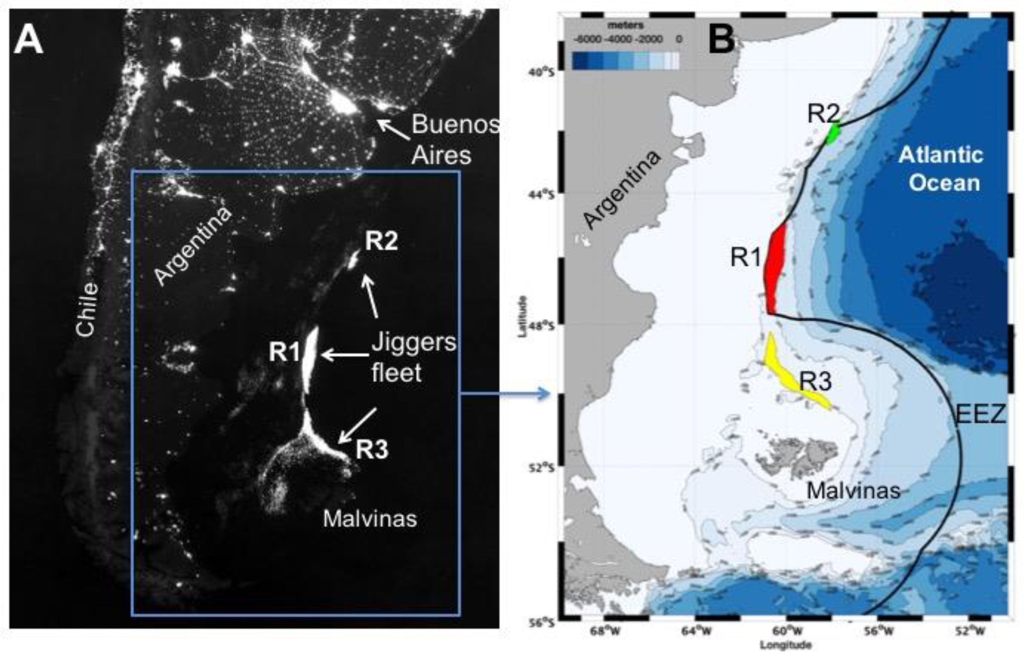
Based on previous examination of the fleet distribution [
12] and a preliminary assessment of an entire mission composite of available radiance data, three regions of interest were differentiated as zones where the jigger fleet tends to cluster in FAO Area 41 (
Figure 1). The first region (R1 in
Figure 1) includes slope waters just at the border of the Argentine exclusive economic zone (EEZ) between parallels 44°S and 48°S and concentrates the majority of jigger activity. The second cluster of jiggers (R2) concentrates also at slope waters at the border of EEZ between parallels 42°S and 41°S. Another group of vessels operates in slope waters but within the EEZ (R3) (
Figure 1).
3. Results
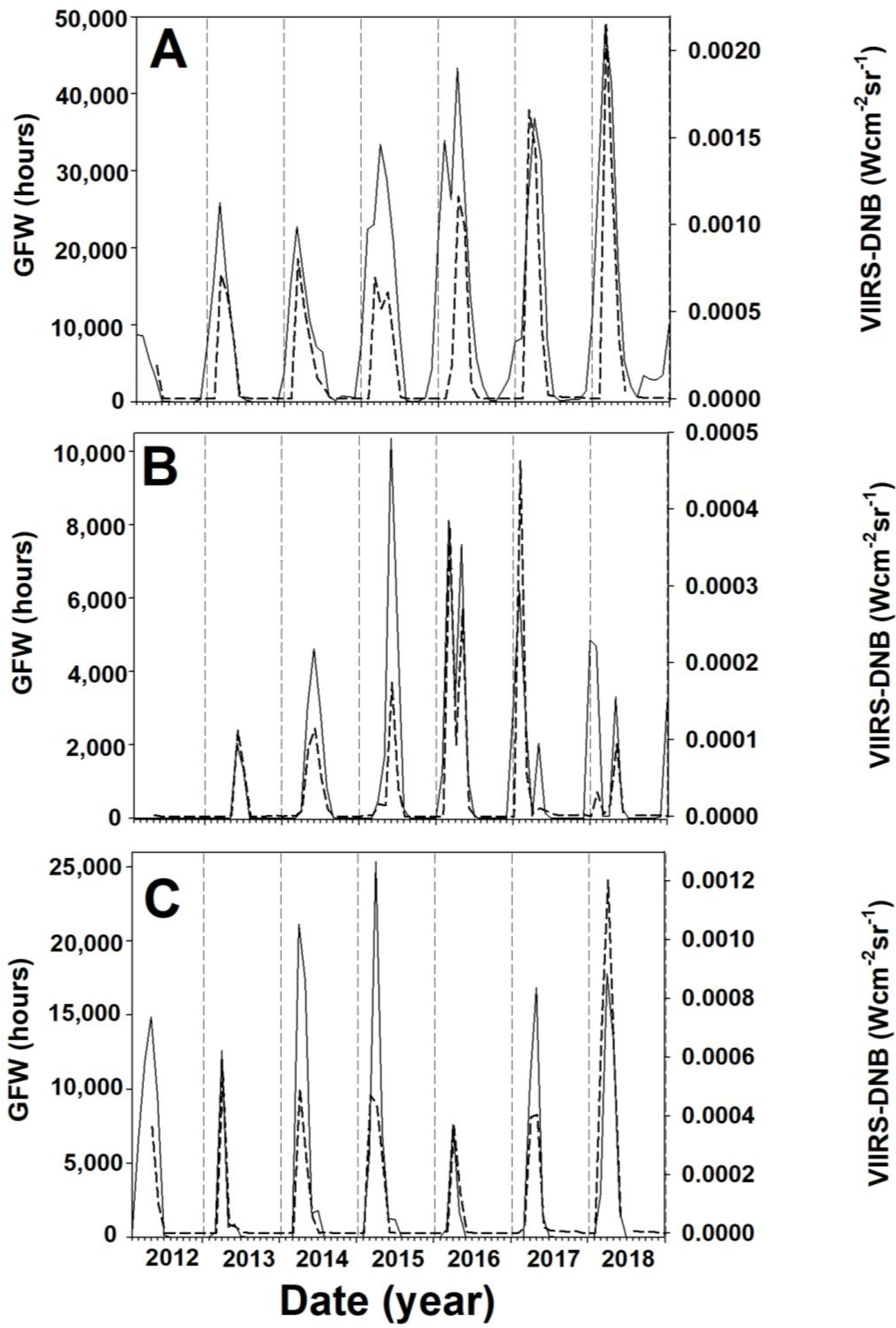
Figure 2 shows the monthly time series of GFW and VIIRS-DNB data for the three regions of interest. Maximum values of GFW and VIIRS-DNB data along the time series vary among the different zones. Thus, GFW maxima for R1, R2 and R3 are 4.88 × 10
4, 1.04 × 10
4 and 2.54 × 10
4 hours, respectively. VIIRS-DNB maxima for R1, R2 and R3 are 21.47 × 10
–4, 4.63 × 10
–4 and 12.10 × 10
–4 W cm
–2 sr
–1, respectively. There is manifestly a seasonal component in the GFW and VIIRS-DNB data series since their maxima are achieved in all regions and years between January and July, whereas both signals drop to zero during the austral winter. The response of fishing effort (GFW) and radiance (VIIRS-DNB) to this seasonal component is highly synchronous. The seasonal component of both signals is evident in their time series for the three regions (
Figure 2).
The time series (
Figure 2) show changes at time scales longer than one year, which might be connected to variations in the fishery landings (
Figure 3). Thus, at time scales longer than the seasonal cycle, both GFW fishing effort and VIIRS-DNB radiance show an increasing tendency in R1, but this trend is not as evident in R2 and R3. The landing collapse of 2016 is not apparent in GFW and VIIRS-DNB at R1 and R2, but it is evident in both signals at R3 (
Figure 2).
Therefore, at any time scale analyzed, GFW and VIIRS-DNB signals behave very consistently in the different regions of interest. Moreover, the range of GFW and VIIRS-DNB values among the three regions also adds evidence for consistency. Thus, dividing GFW maximum in each region by the R2 maximum (the minimum of the maxima) results in the values 4.71, 1 and 2.45 for R1, R2 and R3, respectively. The same exercise for VIIRS-DNB radiance data results in remarkably similar numbers: 4.64, 1 and 2.60. Therefore, both signals do not only show consistent temporal features at seasonal and interannual scales within each region but also show a consistent range of variation across regions.
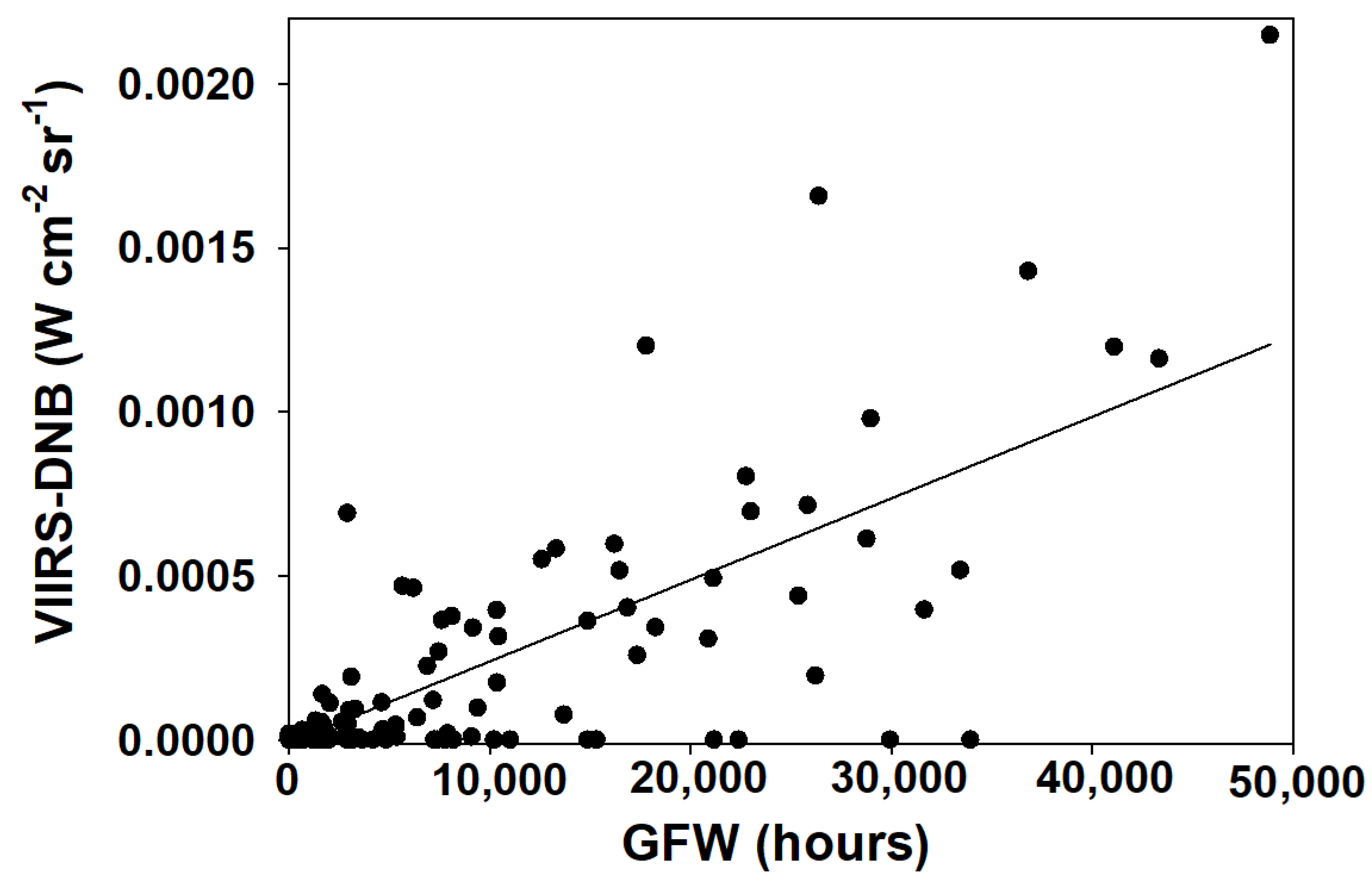
When data from all regions and years are pooled, a scatterplot of VIIRS-DNB radiance versus GFW fishing effort (
Figure 4) reveals correlation between the two variables with a linear regression fit showing a low
p-value (
p < 0.0001) and a high R
2 (R
2 = 0.62). However, despite this close connection between the two variables, there are a few cases when VIIRS-DNB radiance data seem to have missed the vessels in the area. These are evident in
Figure 4 as dots with zero values for VIIRS-DNB radiance data whereas GFW fishing effort reaches values above 2 × 10
4 hours.
Figure 5 shows the ratio of GFW to VIIRS-DNB. Although this ratio varies in a wide range, no tendency is evident in
Figure 5. A linear regression of the logarithm of the ratio versus the number of the month in the time series show a high
p-value (
p = 0.50) and a low R
2 (R
2 = 0.005).
4. Discussion
Spatial and temporal consistency between GFW fishing effort and VIIRS-DNB radiance signals of the squid fishery in FAO Area 41 is very high at all the scales analyzed. Given that GFW and VIIRS-DNB data come from fully independent sources, no artifactual correlation between them can sensibly be expected. Consequently, the most plausible explanation to this high level of consistency is to consider both signals as fair indicators of fishing effort by jiggers, and that changes in fleet activity make GFW and VIIRS-DNB records vary over time and space in the area.
Moreover, the ratio of VIIRS-DNB to GFW signals does not show a significant tendency between 2012 and 2018 (
Figure 5); in particular,
Figure 5 shows no evidence of a ratio which is increasing along the time series. This increment would be a potential indicator of a significant number of AIS transponders being obscured. The lack of tendency in this ratio does not support the view that AIS manipulation is affecting the veracity of GFW as a source of data to assess fishery effort in remote areas. Had a significant manipulation of transceivers occurred after 2012, when GFW started to compile massive AIS data, a manifest trace should be evident in this ratio. Thus, a potential manipulation of transceivers to game the system will alter GFW but not VIIRS-DNB radiance signal since the nature of jigger operation, using powerful lights at night, cannot be hidden to VIIRS-DNB [
10]. A significant manipulation of AIS transceivers would bear a loss of the consistency between GFW and VIIRS-DNB signals reported here.
Our results also confirm previous reports on the suitability of radiometers as a tool to assess effort in this fishery [
20]. Our
Figure 2 and
Figure 3 show features similar to those shown in
Figure 2 of [
20], although in their case the data of vessel presence were obtained from coastal authorities. The authors of [
10] performed this exercise for fisheries in Indonesian waters on a vessel-to-vessel basis where data from the vessel monitoring system (VMS) of coastal authorities (rather than AIS from GFW) were compared with VIIRS-DNB information. They found a high match rate between VMS and VIIRS-DNB information when the gear, as it is our case, utilized high light power during the night. For the portion of the fleet which is not forced to transmit VMS to the coastal state, VIIRS-DNB has shown a good potential to uncover and map fishing activities [
10].
In the databases analyzed here, GFW has more resolution at all levels since it provides data on individual vessels (MMSI, maritime mobile service identity) and works on a daily basis. In addition, GFW is not subject to visibility barriers imposed on VIIRS-DNB detection by atmospheric conditions, which are frequently cloudy in the area [
12] or while lunar illuminance is high under full moon conditions, when the current algorithm produces large numbers of false detection [
9]. These barriers are probably the reason that have prevented an even better correlation between VIIRS-DNB and GFW signals, as evident in the several dots of
Figure 4 where GFW is high whereas VIIRS-DNB is zero. The availability of satellite AIS information and its easy access, thanks to tools such as GFW, makes this an efficient tool to survey the fishery. VIIRS-DNB can then act as a benchmark to detect unjustified deviations in AIS data. This can be particularly useful to this fishery since it includes high sea conditions and diplomatic intricacies in waters under jurisdiction, as well as an important component of distant nations in the configuration of the fleet. As an example,
Figure 2 shows an increased effort in the two high sea regions assessed (R1 and R2) that does not decrease in 2016 when the collapse of the stocks occurs. However, R3, which is under jurisdiction, does show a drop of effort in that particular year.
The consistency between GFW and VIIRS-DNB data observed in this work does not necessarily extrapolate easily to other fisheries. The use of powerful lights makes the fishing vessels very visible to VIIRS-DNB during the night. This is a strategy frequently used in other fisheries like purse seiners [
21], but it is not used with most other types of fishing gear. The authors of [
10] made a detailed assessment of the capacity of VIIRS to detect different types of gear with an overall decrease in those gear types operating at day or not using lights, as expected. In addition, the density of vessels in the fishing area probably helps to avoid any temptation to manipulate AIS transponders since the possibility of a collision is high in these conditions. Despite these limitations, this work adds evidence on the power of radiometers to detect and benchmark other sources of information such as AIS. The panoply of tools increasingly available for the remote sensing of fishing activities in high seas will, consequently, support survey and compliance in areas of the world's oceans where transparency is particularly difficult to achieve.


