Abstract
Owing to the significant societal value of inland water resources, there is a need for cost-effective monitoring of water quality on large scales. We tested the suitability of the recently launched Sentinel-2A to monitor a key water quality parameter, coloured dissolved organic matter (CDOM), in various types of lakes in northern Sweden. Values of a(420)CDOM (CDOM absorption at 420 nm wavelength) were obtained by analyzing water samples from 46 lakes in five districts across Sweden within an area of approximately 800 km2. We evaluated the relationships between a(420)CDOM and band ratios derived from Sentinel-2A Level-1C and Level-2A products. The band ratios B2/B3 (460 nm/560 nm) and B3/B5 (560 nm/705 nm) showed poor relationships with a(420)CDOM in Level-1C and 2A data both before and after the removal of outliers. However, there was a slightly stronger power relationship between the atmospherically-corrected B3/B4 ratio and a(420)CDOM (R2 = 0.28, n = 46), and this relationship was further improved (R2 = 0.65, n = 41) by removing observations affected by light haze and cirrus clouds. This study covered a wide range of lakes in different landscape settings and demonstrates the broad applicability of a(420)CDOM retrieval algorithms based on the B3/B4 ratio derived from Sentinel-2A.
1. Introduction
Long-term water quality information is important for securing and restoring ecosystem services provided by lakes [1]. Lakes are generally small in size and widely distributed in remote locations, which make regular monitoring difficult [2]. For example, Sweden has more than 126,000 lakes, but owing to the time and effort required to conduct monitoring with conventional sampling techniques, the annual Swedish lake monitoring program focuses on only around 100 lakes [3]. Similar challenges are faced by countries in northern boreal and Arctic regions that have an abundance of lakes scattered over large areas with low accessibility.
Water monitoring programs in Europe and North America have observed increases in dissolved organic matter (DOM) over the past decades [4], but knowledge of the geographic extent of these changes remains poor. DOM not only increases the cost of drinking water production and decreases recreational value of lakes, but also impacts the structure and function of aquatic ecosystems [5] through, for example, degradation that leads to greenhouse gas production [5,6] and dissolved oxygen depletion [5,6,7], as well as decreases in light penetration, which suppresses biomass production [8,9]. As these impacts occur at large scales, there is an incentive to develop remote sensing techniques to map DOM in lakes of different sizes over large geographical areas with varying landscape settings.
The coloured fraction of DOM that absorbs light (CDOM) is conventionally described using a coefficient derived from the expression ln(1/T), where T is the proportion (from 0 to 1) of photons transmitted through the CDOM in water per meter at a given wavelength [10]. In most aquatic ecosystems, quantifying CDOM is equivalent to knowing the absolute concentration of DOM in the water [11,12,13], although there can be local variations in the DOM/CDOM relationship [14]. As CDOM absorbs light and modifies the optical characteristics of the water, it can be remotely sensed from satellite observations [15]. Remote sensing can potentially provide new insights into how CDOM is spatially distributed in aquatic environments, and how it responds to climate and land-use change over space and time [15,16,17]. This facilitates effective monitoring of inland water CDOM [18] and the management of water resources, particularly if used in combination with in situ water sampling and monitoring programs [19].
Several sensors for environmental monitoring have been developed for marine applications (e.g., MODerate resolution Imaging Spectroradiometer, MODIS), but their coarse spatial resolutions, ranging from 250 m to 1200 m, are not suitable for most inland waters bodies [15,18,19]. Recently, the potential for inland water applications has been enhanced by the development of sensors with higher spatial and radiometric resolution [20,21,22,23,24]. The Sentinel-2 multispectral instrument (MSI) is a state-of-art sensor with freely available images at a spatial resolution of 10 m in the visible range that was designed for land applications, but with promising utility for monitoring regional lake water quality [25,26,27]. Furthermore, MSI includes 13 spectral bands, a swath width of 290 km, and global revisit times of five days with the twin satellites Sentinel-2A (launched in June 2015) and Sentinel-2B (launched in March 2017) [27].
There are several visible band ratio algorithms that can be used for estimating CDOM (and DOM) concentrations in a variety of lakes [15,28,29]. Most of these are based on the ratio between green and red bands because reflectance is low or negligible in the blue part of the spectrum in the majority of lakes owing to high absorbance by CDOM and/or interference from suspended particulate matter or phytoplankton [29,30]. For example, Toming et al. [29] found that CDOM in nine Estonian lakes followed a power function fitted to the ratio of MSI bands 3 and 4. However, the applicability of Sentinel-2 imagery in this regard is, thus far, largely unexplored and limited to small-scale studies. Furthermore, the extent to which a particular band ratio works for lakes of different sizes, CDOM ranges, topographical settings, and atmospheric conditions is poorly known.
This lack of knowledge calls for an explorative approach to evaluate the efficacy of different band ratios produced by this relatively new satellite to map CDOM at large scales. In this study, we evaluate retrieval algorithms for CDOM using Sentinel-2A MSI data for Swedish lakes with catchment areas that have a combined coverage of approximately 800 km2, distributed across large parts of Sweden. Our research represents the first attempt to assess CDOM at such a large scale using Sentinel-2A data. Thus, the rationale behind our study is to test whether the performance of established CDOM retrieval methods using band ratios still holds at larger scales using Sentinel-2 data. We further discuss the importance of atmospheric corrections, pixel selection, and the handling of data outliers caused by atmospheric conditions.
2. Materials and Methods
2.1. Study Sites and In Situ Measurement
Forty-six lakes were sampled in five different districts in Sweden during the summer of 2016 (Table 1 and Table 2, Figure 1). These are the Norrbotten subarctic unproductive landscape, which consists mainly of birch forest, shrublands, and bare rocks; Västerbotten E, which is characterized by a boreal continuous spruce forest and peat wetlands; Västerbotten W and Jämtland districts, which have strong alpine gradients from lowland spruce to birch forest and further to high alpine conditions; and Värmland, which has a relatively productive boreal forest. All lakes were sampled more than once, but we decided to use data from visits close to dates with Sentinel-2A scenes that had minimum cloud cover. These lakes have no monitoring plan as they are relatively inaccessible, but the site selection was motivated by the need to test the performance of Sentinel-2A in regions where in situ data are rare.

Table 1.
Descriptions of the land cover types in the Sentinel-2 tiles that cover the study area. Norrbotten (33WXR), Västerbotten W (33WWP), Västerbotten E (33WXM-34WDS), Jämtland (33WVM-33VUL-33VVL), Värmland (33VUG).

Table 2.
The identifier, name, region, and coordinates (midpoint) of each lake.
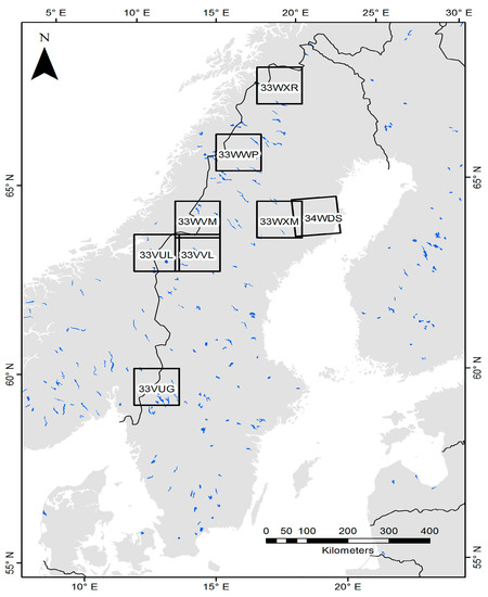
Figure 1.
Locations of the five study regions in Sweden shown as Sentinel-2 tiles: Norrbotten (33WXR), Västerbotten W (33WWP), Västerbotten E (33WXM-34WDS), Jämtland (33WVM-33VUL-33VVL), and Värmland (33VUG).
A representative water sample was collected from each lake by sampling and pooling water from multiple depths (ca. 4–5 evenly distributed depths) within the mixed layer above the thermocline at the deepest point of the lakes. The water samples were kept cool until arrival at the laboratory, where samples were filtered (GF/F = 0.7 µm) and analyzed for absorbance using a Jasco V-560 UV/vis spectrophotometer (Easton, MD, USA). Filtered samples were refrigerated for up to one week after sampling before absorbance analysis. The measured absorbance values were converted to a(420)CDOM in Napierian units (based on a natural logarithm) with the equation a(420)CDOM = 2.303D/r, where D is the measured absorbance and r is the cell path length (in m) [10,31]. Limnologists have used a variety of wavelengths to describe CDOM, and proposed 440 nm as a common standard in North American studies [10]. However, we used 420 nm as it is the wavelength used in the national Swedish monitoring program. The difference between the date of image acquisition and the corresponding in situ data collection ranged approximately between one week to ten weeks, potentially decreasing the accuracy of our models [29]. However, past studies [15,32] have shown that CDOM concentration in lakes is a relatively stable parameter over these durations.
2.2. Satellite Image Processing
Level-1 Sentinel-2 MSI data (L1C) were downloaded from the Scientific Data Hub (https://scihub.copernicus.eu). A total of eight images from between June and October 2016 were downloaded, which covered all 46 lakes from the five different regions. Per-pixel radiometric measurements were provided as top-of-atmosphere (ToA) reflectance. The L1C products had been resampled with a constant ground sampling distance of 10, 20, and 60 m, depending on the native resolution of the different bands, and were delivered as scenes with UTM Zone 33N projection (WGS-84 datum). Images with 10 m and 20 m resolution were used [33]. Sentinel-2 Toolbox version 2.2.4 within the Sentinel Application Platform version 2.2.3 was used to process the images into Level-2A (L2A) surface reflectance using the Sen2Cor atmospheric correction module [33]. Sen2Cor is a processor used to generate Sentinel-2 L2A products, performing atmospheric, terrain, and cirrus cloud correction on the L1C data. Then, 3 × 3 pixel values were extracted from the middle of each lake and the mean values of the pixels were used for analyses. All processing was performed on a 64-bit Windows 10 workstation.
2.3. Statistical Analysis
Partial least squares regression (PLSR) was used to explore the relationships between lake CDOM concentrations and band ratios derived from Sentinel-2A bands 2, 3, 4, and 5 (Table 3). In this way, we were able to systematically evaluate and compare how accurate different ratios performed as CDOM predictors. Any ratio that was most strongly related to CDOM was then regressed against observed a(420)CDOM using power curves [29], which yielded the strongest relationships. A retrieval algorithm was then derived from the resulting regression model of different band ratios. Repeated k-fold cross-validation was performed in order to test the validity of the model. During this procedure, the data were divided into k = 10 portions of equal size, where one of these were retained for validation, while the rest (k – 1) were used for training. The procedure was repeated five times to reduce variance. Model performance was assessed using the root-mean-square error (RMSE) and mean absolute error (MAE).

Table 3.
Resolution, radiometry, and signal-to-noise ratio (SNR) of the Sentinel-2 bands used in this study.
3. Results
3.1. In Situ a(420)CDOM Measurements and Satellite Image Acquisition
The a(420)CDOM in the 46 lakes, as measured in the laboratory, varied from 0.30 m−1 to 29.93 m−1 (Table 4). The highest a(420)CDOM was recorded in seven lakes (IDs: 3, 24, 28, 30, 32, 33, 38) in Värmland and Västerbotten E with values between 21.2 m−1 and 29.9 m−1. The clearest lakes were located in Västerbotten W, Jämtland, and Norrbotten, with observed a(420)CDOM between 0.4 m−1 and 2.4 m−1. The reflectance of the lakes in the different regions was generally high in the green band (B3: 560 nm) and low in the red band (B4: 665 nm) (Figure 2).

Table 4.
Dates of in situ sampling and image acquisition of Sentinel-2A, and the physical characteristics of the lakes.
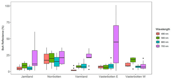
Figure 2.
Reflectance spectra of 46 lakes in the five Swedish regions in this study. Reflectance values are bottom-of-atmosphere reflectance (BoA) after atmospheric correction. The wavelengths signify the central value in each band, as shown in Table 3.
3.2. Partial Least Squares Regression (PLSR) Model to Explore the Relationship between CDOM and Band Ratios
A PLSR analysis was used to explore the relationships between a(420)CDOM sampled in the lakes and the atmospherically-corrected band ratios. Two significant components were evident from the PLSR analysis. The first explained 40% of the variance in CDOM and was characterized by positive loadings weights for all band ratios. The second component explained that 34% of the variance in CDOM was characterized by positive loadings for ratios with B2 as the numerator, but with negative loadings for ratios with B3 as the numerator (Figure 3). The band ratio B3/B4 clearly showed the strongest relationship to a(420)CDOM as these two variables were located on the diagonally opposite end in the loading plot (Figure 3). The other band ratios, especially B2/B3, B2/B5, and B2/B4, were less clearly linked with a(420)CDOM. The PLSR of the non-atmospherically-corrected L1C data (not shown) was excluded because of poor model fit.
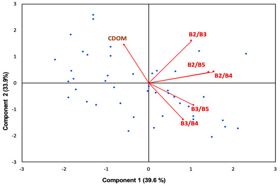
Figure 3.
Partial least squares regression (PLSR) model with different band ratios variables as predictors (after atmospheric correction) and coloured dissolved organic matter (CDOM) as a response variable, based on data from 46 lakes in five different regions in Sweden. Vectors show loadings (PLS weights), scaled by a factor of 2 to fit the biplot with site scores. The site scores are shown in blue filled circles.
3.3. Testing and Validating a(420)CDOM Retrieval Models
The B2/B3 explained 24% of the a(420)CDOM variation before atmospheric correction (Figure 4A), but this relationship was not significant after atmospheric correction (Figure 4B). The green to red band ratio (B3/B4), which has been commonly used to retrieve CDOM in lakes in the past, had a relatively stronger correlation with the lake a(420)CDOM (Figure 4D). Before atmospheric correction, B3/B4 did not significantly explain any variance (R2 = 0.01) in a(420)CDOM (Figure 4C), but after atmospheric correction the relationship was markedly improved (R2 = 0.28; Figure 4D). The B3/B5 ratio showed patterns similar to those of B3/B4, but with slightly lower R2 (Figure 4E,F).
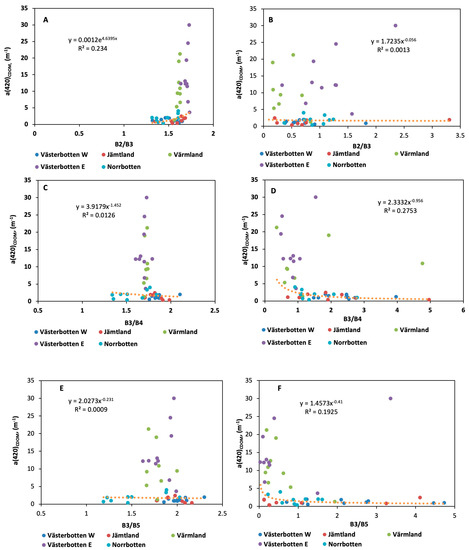
Figure 4.
Relationships between ratio bands (B2/B3, B3/B4, B3/B5) calculated from Sentinel-2A data and in situ colored dissolved organic matter a(420)CDOM concentration measured: panels (A,C,E) are band ratios calculated from the top of atmosphere reflectance (L1C) data; and panels (B,D,F) are band ratios calculated from the bottom of atmosphere reflectance (L2A) data.
Model coefficients estimated from Sentinel-2A before (L1C) and after atmospheric correction (L2A) (Table 5) showed that B2/B3 had relatively higher explained variance and lower error and bias, in comparison with B2/B3 and B3/B5, before atmospheric correction. On the other hand, B3/B4 after the atmospheric correction showed the highest explained variance (R2 = 0.28). Surprisingly, B3/B4 after atmospheric correction had slightly higher error and bias than B3/B4 and B3/B5 (Table 5).

Table 5.
Retrieval models for a(420)CDOM estimated from Sentinel-2A before (b, no shading) and after (a, grey shading) atmospheric correction. RMSE, root-mean-square error; MAE, mean absolute error; the variable X denotes the band ratio in the model equation.
The repeated k-fold cross-validation showed that, after atmospheric correction, the B3/B4a ratio had the highest explained variance (R2 = 0.49; Table 6). The RMSE showed substantially lower error and bias in B3/B4a in comparison with that found for other band ratios. This bolsters our confidence in using B3/B4 as a robust approach to predicting a(420)CDOM in lake water (Figure 5).

Table 6.
The repeated k-fold cross-validation results of the performance of the Sentinel-2A band ratios for 46 lakes before (b, no shading) and after (a, grey shading) atmospheric correction.
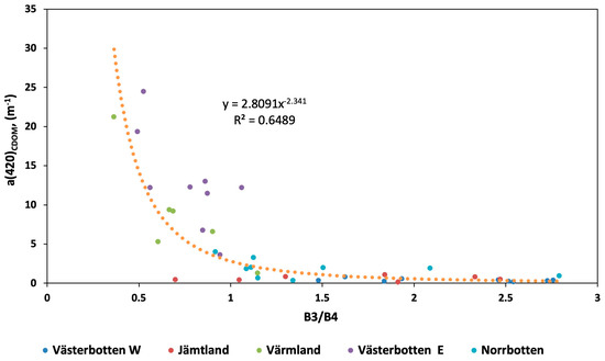
Figure 5.
Power relationship between the CDOM absorption coefficient at 420 nm and the ratio of band 3 to band 4, calculated from Sentinel-2A data after the outliers were removed (n = 5), based on the results from 41 Swedish lakes.
The final model explained a relatively high proportion of the variance in CDOM (R2 = 0.65) after the removal of outliers that were strongly affected by atmospheric conditions like haze and thin cirrus clouds (Figure 5). These outliers were not detected during the initial screening process in which we removed lakes that were completely covered by clouds because they had some cirrus clouds and haze that were harder to detect with the naked eye. Thus, they were removed in a secondary, and more detailed, inspection. As this study aims to test the efficiency of the MSI sensor for mapping CDOM concentrations at large scales rather than developing a new algorithm, we applied the final model from Table 7 to retrieve a(420)CDOM for the 41 lakes.

Table 7.
The best performing a(420)CDOM retrieval model estimated from the validation subset after atmospheric correction (a) and removal of outliers (n = 5). The variable X denotes the band ratio in the model equation.
3.4. Comparing Observed and Modeled a(420)CDOM and Mapping Its Variability
Modeled and in situ, a(420)CDOM exhibited similar patterns and ranges across the study regions (Figure 6). Västerbotten E and Värmland had the highest a(420)CDOM concentrations and the highest variability. On the other hand, Jämtland and Norrbotten had the lowest variability in remotely sensed a(420)CDOM and clearer water compared with that of the other regions.
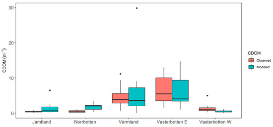
Figure 6.
CDOM absorption coefficient at 420 nm, calculated from Sentinel-2A data and water sample, based on the results from 41 Swedish lakes.
The concentration of a(420)CDOM varied considerably within some of the lakes, as shown in Figure 7, where the spatial variation in a(420)CDOM of ten lakes in Västerbotten W is presented. For example, modeled a(420)CDOM was notably higher at the edges of several lakes compared with values derived from the middle pixels (Figure 7). On the other hand, for example, lakes 9–10 showed considerably less a(420)CDOM variability (Figure 7). In spite of this edge effect, the a(420)CDOM retrieval also worked well in very small lakes. For example, one of the smallest lakes in the dataset (Lake 1, Skrapmiejaure), which is 0.07 km2 in area, was still large enough for a(420)CDOM to be acquired (0–0.3 m−1) from clean mid-lake pixels, owing to the high spatial resolution of the Sentinel-2A data.
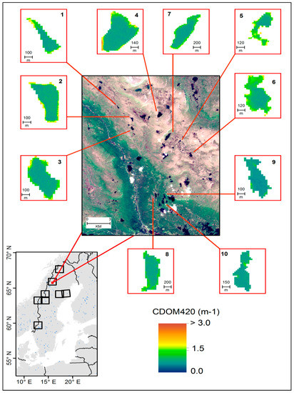
Figure 7.
CDOM spatial gradient in lakes 1 to 10 covering Västerbotten W (33WWP). The base image in the central panel is Sentinel-2A true color composite taken on 21 July 2016. Note that Västerbotten W had some of the lowest in situ CDOM values (see Table 4 and Figure 5), which explains the low maximum in this figure.
4. Discussion
4.1. Band Ratio Algorithms
Several band ratio combinations were tested in this study and the B3/B4 ratio was found to perform best. In lakes with low CDOM concentrations, phytoplankton and other particles cause the green range (~560 nm, band 3) of the electromagnetic spectrum to reflect highly, while the red portion (665 nm, band 4) is mostly absorbed [17,34]. As CDOM increases, relatively more of the green light, as compared with the red light, will be absorbed, and thus relatively more red light, compared with green, remains available to be reflected back to the atmosphere (Figure 2). CDOM level may vary in the water columns, depending on the spectral interference from high concentrations of particulate matter (Figure 2). Zhu, W et al. [34] tested many empirical algorithms with lake data and suggested that wavelengths greater than 600 nm are critical for correct estimation of CDOM in complex freshwater ecosystems. In this study, we emphasize that the combination of the bands B3 and B4 in a ratio can capture the contrasting responses of these bands, and give a reasonable measure of a(420)CDOM content in the water.
The applicability of the Sentinel-2A data for estimating lake a(420)CDOM was highlighted by Toming et al. [29], who applied it to a relatively small area in Estonia. The primary limitation of their analysis is that the derived empirical relationship might only be valid for the small subset of lakes that were included in the study. We expanded the scope to include a much larger region and nearly three times the number of lakes and found a higher explained variance (R2 = 0.65) for the relationship between a(420)CDOM and the B3/B4a ratio than Toming et al. [29] (R2 = 0.52). It is important to note that lake a(420)CDOM concentrations are influenced by several factors such as lake conditions, surrounding land cover and land use, topography, and atmospheric interference. In this regard, the strength of our approach is that the model developed involves a larger sample of lakes across a relatively larger spatial area with heterogeneous land cover and topography.
4.2. Atmospheric Effects
Generally, atmospheric correction must be applied to avoid unwanted illumination effects that may be larger than the variability in water parameters. However, Toming et al. [29] found that, for Sentinel-2A, the a(420)CDOM retrieval on small scale (single image) results were better when atmospherically uncorrected imagery was used. On a large scale, involving multiple images, we found that a(420)CDOM retrieval was more successful when atmospheric correction was applied to the imagery. We evaluated the added-value of using Sen2Cor by comparing the in situ and modelled a(420)CDOM before and after atmospheric correction using the B3/B4a band ratios. On the basis of this analysis, we found that atmospheric correction worked well in general and the algorithm performance was evaluated using repeated k-fold cross-validation to obtain more reasonable estimates of model coefficients. As shown in Table 5, any differences in the spectra can lead to large differences in the absolute accuracy of band ratios retrieval of a(420) CDOM. This can be explained in terms of biases and uncertainties that are dependent on spectral measurements of each band ratio.
Although we were not able to collect reflectance data in the field to compare it with the reflectance of acquired images, we were able to rate the performance of Sen2Cor by comparing the ToA and BoA reflectance spectra. We found that the reflectance spectra performed better in most regions after atmospheric correction. That being said, data from some sampling stations do not fit the general relationship well (Figure 4D). We investigated the specific images collocated with these sampling stations and found that there are residual signals in the blue and near-infrared wavelengths where water reflectance is supposed to be zero. This was because of persistent atmospheric effects, which indicate that either sun glint, light haze, or cirrus clouds were present, or potentially a combination of all of these conditions. Therefore, five lakes were removed from the dataset, and data from 41 lakes were used in the subsequent analyses (Figure 5).
4.3. Spatial Variability of a(420)CDOM
In complex freshwater systems, a(420)CDOM often displays a broad range of values, likely influenced by catchment characteristics (e.g., vegetation type or density, or land cover variety). Such heterogeneous and often small lakes present a challenge to current remote sensing methods used to estimate biological and chemical properties of water [34,35]. Previous studies found that surrounding sources of carbon (e.g., vegetation, soils) enhance the a(420)CDOM values in lake water [36,37,38,39,40]. In our study area, specifically in Västerbotten E, wetlands are significantly represented in the total catchment area. Moreover, Västerbotten E and Värmland are dominated by a mix of broadleaf and coniferous forests, which could further explain the high values of a(420)CDOM in those regions (<5.5 to >10.5 m−1; Figure 6, Table 4) [41,42]. On the other hand, Jämtland has the lowest percentage of forest and is mostly covered by herbaceous cover (Table 1). This could be the reason for the low a(420)CDOM levels found in this region (<2 m−1, Figure 6 and Table 4) that cause more transparent water compared with other regions. Västerbotten W has a large proportion of mixed types of forest and herbaceous cover, which probably explains why a(420)CDOM at the edges of lakes in this region has high values in comparison with those found at lake centres. Depending on the size and depth of a lake and the heterogeneity of the topography, land cover, and land-use surrounding it, there could be a high variability of a(420)CDOM from the periphery to the lake centre. Therefore, it cannot be ruled out that lake bottom reflectance biases remote sensing measurements near the lake shore. Norrbotten has a mixture of different types of broadleaf forests and coniferous, herbaceous cover, and wetlands. The lakes in Norrbotten show a significant variation in a(420)CDOM (0.6–4.6 m−1; Figure 6, Table 4). Overall, the lakes in areas surrounded by mixed forests had the highest levels of a(420)CDOM, as compared with lakes surrounded by herbaceous vegetation or heathlands (Table 1). The contribution of different land cover types to the spatial patterns of a(420)CDOM in these lakes will be comprehensively assessed in a follow-up study (Supplementary Data; Figures S1 and S2).
4.4. Temporal Variability of a(420)CDOM
The in situ a(420)CDOM measurements were obtained between July and August of 2016, and the Sentinel-2A images were collected in June, July, August, September, and October of the same year. Matching water sampling and satellite image acquisition in time was a challenge. The time difference was up to two weeks in all areas, except in boreal lakes in Västerbotten E; these had a difference in time of up to ten weeks.
Thus, a potential problem with our analysis is that there was a mismatch of up to approximately 10 weeks between the field sampling date and the date of the image that was available for analysis. However, Cardille et al. [32] suggested that a such a time difference will not significantly affect the relationship between measured and remotely sensed CDOM. In our case, the timing appeared to be sufficient for this study, and justified by the fact that our model was able to explain 65% of the variability in a(420)CDOM, which is relatively high compared with other studies [29,30,43] that used Sentinel-2 data. The a(420)CDOM in boreal headwater lakes varies only marginally during the summer and we can expect relatively small temporal a(420)CDOM variations [44]. Weather conditions were stable during the study period, for example, maximum daily temperatures from June to September ranged between 18 °C and 25 °C, and precipitation was relatively low, between 25 and 45 mm. There were no heavy rain events between image acquisition and in situ data measurements that could bring particles or dissolved materials into the lakes, nor were algal blooms reported during the study period.
5. Summary and Conclusions
We presented an application of mapping lake coloured dissolved organic matter (CDOM) by modelling a(420)CDOM that may cause changes to water colour. In situ field measurements were taken from 46 lakes across northern Sweden during the summer of 2016 and eight images from the Sentinel-2A Multispectral Imager were acquired from the same season. Band ratios based on Sentinel-2A data were used to model lake a(420)CDOM. The best performing algorithm was based on the B3/B4 ratio, and it showed robust and consistent results across a broad range of lakes of different sizes distributed over varying landscapes. Sixty-five percent (R2 = 0.65) of the variability of in situ CDOM was explained by the model. We found that atmospherically-corrected Sentinel-2 imagery produced better results than uncorrected imagery. However, we observed that the residual signal in atmospherically-corrected imagery may have been the result of sun glint, haze, or thin clouds that persisted despite the use of atmospheric correction. This study demonstrates the effective use of Sentinel-2 for this application over a wide range of inland waters that are situated in complex and inaccessible regions that are not well-monitored.
Supplementary Materials
The following are available online at https://www.mdpi.com/2072-4292/12/1/157/s1, Figure S1: Mapping 46 lakes in five study regions in Sweden using Sentinel-2 images; Västerbotten W (33WWP) acquired on 21 July 2016, Jämtland (33WVM-33VUL-33VVL) acquired on 30 July 2016, and Värmland (33VUG) acquired on 4 June 2016; Figure S2: Mapping 46 lakes in five study regions in Sweden using Sentinel-2 images; Västerbotten E (33WXM-34WDS) acquired on 12 October 2016 and Norrbotten (33WXR) acquired on 30 July 2016.
Author Contributions
The study was jointly designed by M.B. and D.E.T.; E.S.A.-K. was responsible for processing and analyzing Sentinel-2 imagery and wrote the manuscript with input from all co-authors; D.E.T. provided all technical support for the data analysis and contributed to the writing; A.M.A. helped in mapping CDOM and contributed to the writing; T.K. assisted in the processing data of Sentinel-2; J.K. supported to provide some of field data; A.-K.B. provided some of the field data; M.B., D.E.T. and A.M.A. assisted in writing in and enhancing the manuscript together with E.S.A.-K. All authors have read and agreed to the published version of the manuscript.
Funding
This research was funded by the Royal Physiographic Society of Lund, Sweden (Grant No. 161116), and Stiftelse ÅForsk. The APC was funded by Helge Ax:son Johnsons Stiftelse, Sweden (F18-0483). Enass Said. Al-Kharusi is supported by national programme of postgraduate studies under the Ministry of Higher Education, Sultanate of Oman. Abdulhakim M. Abdi is supported by the Swedish Research Council (Grant No. 2018-00430).
Acknowledgments
We thank Bror Holmgren at Umeå University for providing field data. We are grateful to Helge Ax:son Johnsons Stiftelse, Sweden for supporting the research visit of Tiit Kutser at École Polytechnique Fédérale de Lausanne.
Conflicts of Interest
The authors declare there is no conflict of interest.
References
- Birk, S.; Ecke, F. The Potential of Remote Sensing in the Ecological Status. Assessment of Coloured Lakes Using Aquatic Plants. Ecol. Indic. 2014, 46, 398–406. [Google Scholar] [CrossRef]
- Verpoorter, C.; Kutser, T.D.; Seekell, A.; Tranvik, L.J. A Global Inventory of Lakes Based on High-Resolution Satellite Imagery. Geophys. Res. Lett. 2014, 41, 6396–6402. [Google Scholar] [CrossRef]
- Fölster, J.; Johnson, R.K.; Futter, M.N.; Wilander, A. The Swedish monitoring of surface waters: 50 years of adaptive monitoring. Ambio 2014, 43, 3–18. [Google Scholar] [CrossRef]
- Monteith, D.T.; Stoddard, J.L.; Evans, C.D.; De Wit, H.A.; Forsius, M.; Høgåsen, T.; Wilander, A.; Skjelkvåle, B.L.; Jeffries, D.S.; Vourenmaa, J.; et al. Dissolved Organic Carbon Trends Resulting from Changes in Atmospheric Deposition Chemistry. Nature 2007, 450, 537. [Google Scholar] [CrossRef]
- Jansson, M.; Persson, L.; DeRoos, A.M.; Jones, R.I.; Tranvik, L.J. Terrestrial Carbon and Intraspecific Size-Variation Shape Lake Ecosystems. Trends Ecol. Evol. 2007, 22, 316–322. [Google Scholar] [CrossRef]
- Lapierre, J.F.; Guillemette, F.; Berggren, M.; del Giorgio, P.A. Increases in Terrestrially Derived Carbon Stimulate Organic Carbon Processing and CO2 Emissions in Boreal Aquatic Ecosystems. Nat. Commun. 2013, 4, 2972. [Google Scholar] [CrossRef]
- Brothers, S.; Köhler, J.; Attermeyer, K.; Grossart, H.P.; Mehner, T.; Meyer, N.; Scharnweber, K.; Hilt, S. A Feedback Loop Links Brownification and Anoxia in a Temperate, Shallow Lake. Limnol. Oceanogr. 2014, 59, 1388–1398. [Google Scholar] [CrossRef]
- Karlsson, J.; Byström, P.J.; Ask, P.; Ask, L.; Persson, L.; Jansson, M. Light Limitation of Nutrient Poor Lake Ecosystems. Nature 2009, 460, 506. [Google Scholar] [CrossRef]
- Deininger, A.; Faithfull, C.L.; Bergström, A.-K. Phytoplankton Response to Whole Lake Inorganic N Fertilization along a Gradient in Dissolved Organic Carbon. Ecology 2017, 98, 982–994. [Google Scholar] [CrossRef]
- Cuthbert, I.D.; del Giorgio, P. Toward a Standard Method of Measuring Color in Freshwater. Limnol. Oceanogr. 1992, 37, 1319–1326. [Google Scholar] [CrossRef]
- Brezonik, P.; Menken, K.D.; Bauer, M. Landsat-based Remote Sensing of Lake Water Quality Characteristics, Including Chlorophyll and Colored Dissolved Organic Matter (CDOM). Lake Reserv. Manag. 2005, 21, 373–382. [Google Scholar] [CrossRef]
- Harvey, E.T.; Kratzer, S.; Andersson, A. Relationships between Colored Dissolved Organic Matter and Dissolved Organic Carbon in Different Coastal Gradients of the Baltic Sea. Ambio 2015, 44, S392–S401. [Google Scholar] [CrossRef]
- Keith, D.J.; Schaeffer, B.A.; Lunetta, R.S.; Gould, R.W.; Rocha, K.; Cobb, D.J. Remote Sensing of Selected Water-Quality Indicators with the Hyperspectral Imager for the Coastal Ocean (HICO) Sensor. Int. J. Remote Sens. 2014, 35, 2927–2962. [Google Scholar] [CrossRef]
- Song, K.; Zhao, Y.; Wen, Z.; Chong, F.; Shang, Y. A systematic examination of the relationships between CDOM and DOC in inland waters in China. Hydrol. Earth Syst. Sci. 2017, 21, 5127. [Google Scholar] [CrossRef]
- Kutser, T.; Pierson, D.C.; Kallio, K.Y.; Reinart, A.; Sobek, S. Mapping Lake CDOM by Satellite Remote Sensing. Remote Sens. Environ. 2005, 94, 535–540. [Google Scholar] [CrossRef]
- Kuster, T. The Possibility of Using the Landsat Image Archive for Monitoring Long Trend in Colored Dissolved Organic Matter Concentration in Lake Waters. Remote Sens. Environ. 2012, 123, 334–338. [Google Scholar]
- Gholizadeh, M.; Melesse, A.; Reddi, L. A Comprehensive Review on Water Quality Parameters Estimation Using Remote Sensing Techniques. Sensors 2016, 16, 1298. [Google Scholar] [CrossRef]
- Klein, I.; Gessner, U.; Dietz, A.J.; Kuenzer, C. Global WaterPack—A 250 m Resolution Dataset Revealing the Daily Dynamics of Global Inland Water Bodies. Remote Sens. Environ. 2017, 198, 345–362. [Google Scholar] [CrossRef]
- Tyler, A.N.; Svab, E.; Preston, T.; Présing, M.; Kovács, W.A. Remote Sensing of the Water Quality of Shallow Lakes: A Mixture Modelling Approach to Quantifying Phytoplankton in Water Characterized by High-Suspended Sediment. Int. J. Remote Sens. 2006, 27, 1521–1537. [Google Scholar] [CrossRef]
- Hakvoort, H.; De Haan, J.; Jordans, R.; Vos, R.; Peters, S.; Rijkeboer, M. Towards Airborne Remote Sensing of Water Quality in the Netherlands—Validation and Error Analysis. ISPRS J. Photogramm. Remote Sens. 2002, 57, 171–183. [Google Scholar] [CrossRef]
- Arenz, R.F.; Lewis, W.M.; Saunders, J.F. Determination of Chlorophyll and Dissolved Organic Carbon from Reflectance Data for Colorado Reservoir. Int. J. Remote Sens. 1996, 17, 1547–1566. [Google Scholar] [CrossRef]
- Jaffé, R.; McKnight, D.; Maie, N.; Cory, R.; McDowell, W.H.; Campbell, J.L. Spatial and Temporal Variations in DOM Composition in Ecosystems: The Importance of Long-Term Monitoring of Optical Properties. J. Geophys. Res. Biogeosci. 2008, 113. [Google Scholar] [CrossRef]
- Sasaki, H.; Gomi, Y.; Asai, T.; Shibata, M.; Kiyomoto, Y.; Okamura, K.; Nishiuchi, K.; Hasegawa, T.; Yamada, H. Unique Dispersal of the Changjiang-Diluted Water Plume in the East China Sea Revealed from Satellite Monitoring of Colored Dissolved Organic Matter (CDOM). Terr. Atmos. Ocean. Sci. 2014, 25, 279–287. [Google Scholar] [CrossRef]
- Palmer, S.C.J.; Kutser, T.; Hunter, P.D. Remote Sensing of Inland Waters: Challenges, Progress and Future Directions. Remote Sens. Environ. 2015, 157, 1–8. [Google Scholar] [CrossRef]
- Drusch, M.; Del Bello, U.; Carlier, S.; Colin, O.; Fernandez, V.; Gascon, F.; Bargellini, P. Sentinel-2: ESA’s Optical High-Resolution Mission for GMES Operational Services. Remote Sens. Environ. 2012, 120, 25–36. [Google Scholar] [CrossRef]
- Baillarin, S.J.; Meygret, A.; Dechoz, C.; Petrucci, B.; Lacherade, S.; Tremas, T.; Isola, C.; Martimort, P.; Spoto, F. Sentinel-2 level 1 Products and Image Processing Performances. In Proceedings of the IEEE International Geoscience and Remote Sensing Symposium, Munich, Germany, 22–27 July 2012. [Google Scholar]
- Salama, M.S.; Radwan, M.; van der Velde, R. A Hydro-Optical Model for Deriving Water Quality Variables from Satellite Images (Hydrosat): A Case Study of The Nile River Demonstrating the Future Sentinel-2 Capabilities. Phys. Chem. Earth 2012, 50, 224–232. [Google Scholar] [CrossRef]
- Slonecker, E.T.; Jones, D.K.; Pellerin, B.A. The New Landsat 8 Potential for Remote Sensing of Colored Dissolved Organic Matter (CDOM). Mar. Pollut. Bull. 2015, 107, 518–527. [Google Scholar] [CrossRef]
- Toming, K.; Kutser, T.; Laas, A.; Sepp, M.; Paavel, B.; Nõges, T. First Experiences in Mapping Lakewater Quality Parameters with Sentinel-2 MSI Imagery. Remote Sens. 2016, 8, 640. [Google Scholar] [CrossRef]
- Kutser, T.; Paavel, B.; Verpoorter, C.; Ligi, M.; Soomets, T.; Toming, K.; Casal, G. Remote Sensing of Black Lakes and Using 810 Nm Reflectance Peak for Retrieving Water Quality Parameters of Optically Complex Waters. Remote Sens. 2016, 8, 497. [Google Scholar] [CrossRef]
- Kirk, J.T.O. Light and Photosynthesis in Aquatic Ecosystem; Cambridge University Press: Cambirdge, UK, 1983. [Google Scholar]
- Cardille, J.A.; Leguet, J.B.; del Giorgio, P. Remote Sensing of Lake CDOM Using Noncontemporaneous Field Data. Can. J. Remote Sens. 2013, 39, 118–126. [Google Scholar] [CrossRef]
- ESA. SENTINEL-2UserHandbook. 2015. Available online: https://sentinel.esa.int›documents›Sentinel-2_User_Handbook (accessed on 24 July 2015).
- Zhu, W.; Yu, Q.; Tian, Y.Q.; Becker, B.L.; Zheng, T.; Carrick, H.J. An Assessment of Remote Sensing Algorithms for Colored Dissolved Organic Matter in Complex Freshwater Environments. Remote Sens. Environ. 2014, 140, 766–778. [Google Scholar] [CrossRef]
- Kallio, K.; Attila, J.; Härmä, P.; Koponen, S.; Pulliainen, J.; Hyytiäinen, U.-M.; Pyhälahti, T. Landsat ETM+ Images in the Estimation of Seasonal Lake Water Quality in Boreal River Basins. Environ. Manag. 2008, 42, 511–522. [Google Scholar] [CrossRef]
- Li, J.; Yu, Q.; Tian, Y.; Becker, B.; Siqueira, P.; Torbick, N. Spatio-temporal variations of CDOM in shallow inland waters from a semi-analytical inversion of Landsat-8. Remote Sens. Environ. 2018, 218, 198–200. [Google Scholar] [CrossRef]
- Kelly, P.T.; Solomon, C.T.; Weidel, B.C.; Jones, S.E. Terrestrial carbon is a resource, but not a subsidy, for lake zooplankton. Ecology 2014, 95, 1236–1242. [Google Scholar] [CrossRef]
- Kritzberg, E.S.; Cole, J.J.; Pace, M.L.; Granéli, W.; Bade, D.L. Autochthonous versus allochthonous carbon sources of bacteria: Results from whole-lake 13C addition ex-periments. Limnol. Oceanogr. 2004, 49, 588–596. [Google Scholar] [CrossRef]
- Boyle, E.S.; Guerriero, N.; Thiallet, A.; Vecchio, R.D.; Blough, N.V. Optical prop—Erties of humic substances and CDOM: Relation to structure. Environ. Sci. Technol. 2009, 43, 2262–2268. [Google Scholar] [CrossRef]
- Williams, C.J.; Yamashita, Y.; Wilson, H.F.; Jaffé, R.; Xenopoulos, M.A. Unraveling the role of land use and microbial activity in shaping dissolved organic matter characteristics in stream ecosystems. Limnol. Oceanogr. 2010, 55, 1159. [Google Scholar] [CrossRef]
- Maie, N.; Jaffé, R.; Miyoshi, T.; Childers, D.L. Quantitative and qualitative aspects of dissolved organic carbon leached from senescent plants in an oligotrophic wetland. Biogeochemistry 2006, 78, 285–314. [Google Scholar] [CrossRef]
- Yallop, A.; Clutterbuck, B. Land management as a factor controlling dissolved organic carbon release from upland peat soils 1: Spatial variation in DOC pro-ductivity. Sci. Total. Environ. 2009, 407, 3803–3813. [Google Scholar] [CrossRef]
- Chen, J.; Zhu, W.; Tian, Y.Q.; Yu, Q.; Zheng, Y.; Huang, L. Remote estimation of colored dissolved organic matter and chlorophyll—A in Lake Huron using Sentinel-2 measurements. J. Appl. Remote Sens. 2017, 11, 036007. [Google Scholar] [CrossRef]
- Berggren, M.; Klaus, M.; Selvam, B.P.; Ström, L.; Laudon, H. Quality transformation of dissolved organic carbon during water transit through lakes: Contrasting controls by photochemical and biological processes. Biogeosciences 2018, 15, 457–470. [Google Scholar] [CrossRef]
© 2020 by the authors. Licensee MDPI, Basel, Switzerland. This article is an open access article distributed under the terms and conditions of the Creative Commons Attribution (CC BY) license (http://creativecommons.org/licenses/by/4.0/).