Classifying Inundation in a Tropical Wetlands Complex with GNSS-R


Abstract
:1. Introduction
2. Theoretical Background
2.1. Measurement Definition
2.2. Sensitivity to Inundation
3. GNSS-R Measurements
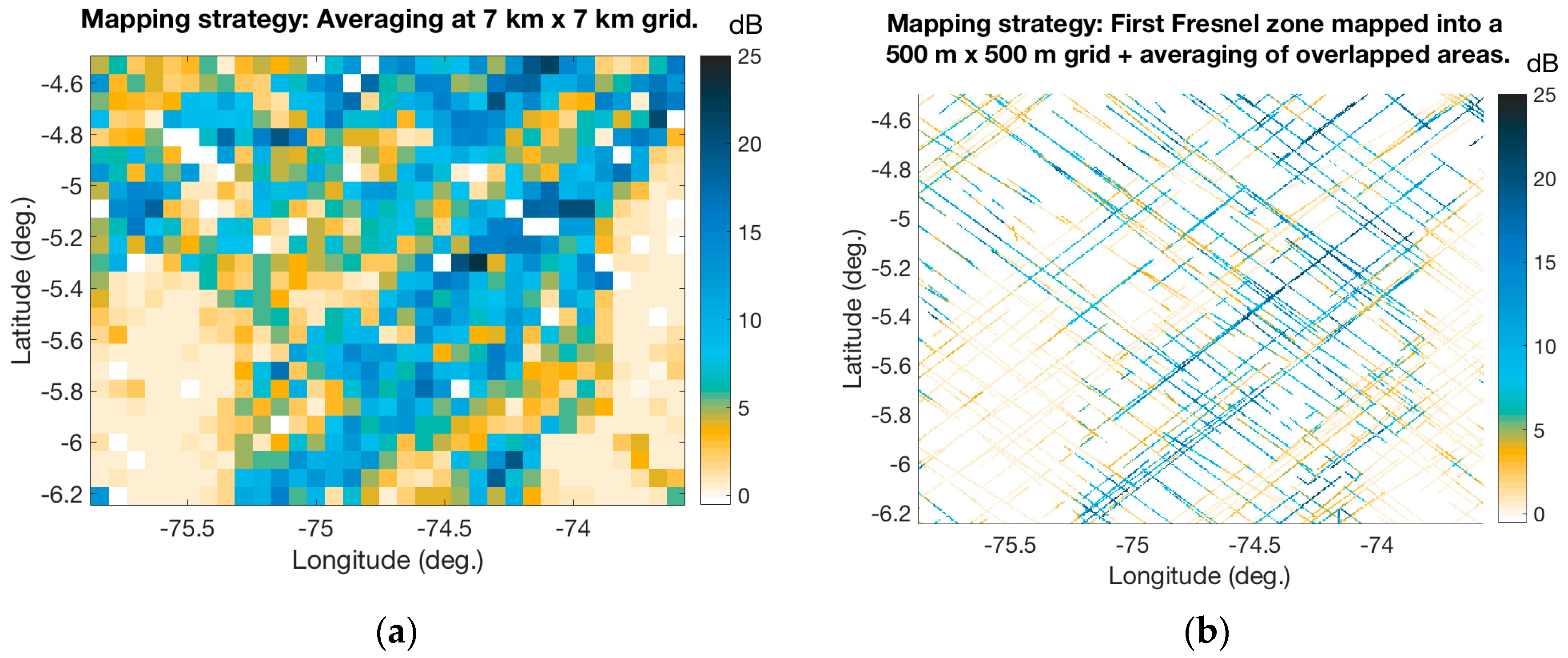
3.1. GNSS-R Measurement Time Averaging
3.2. GNSS-R Observable Definitions
4. Classification Methodology
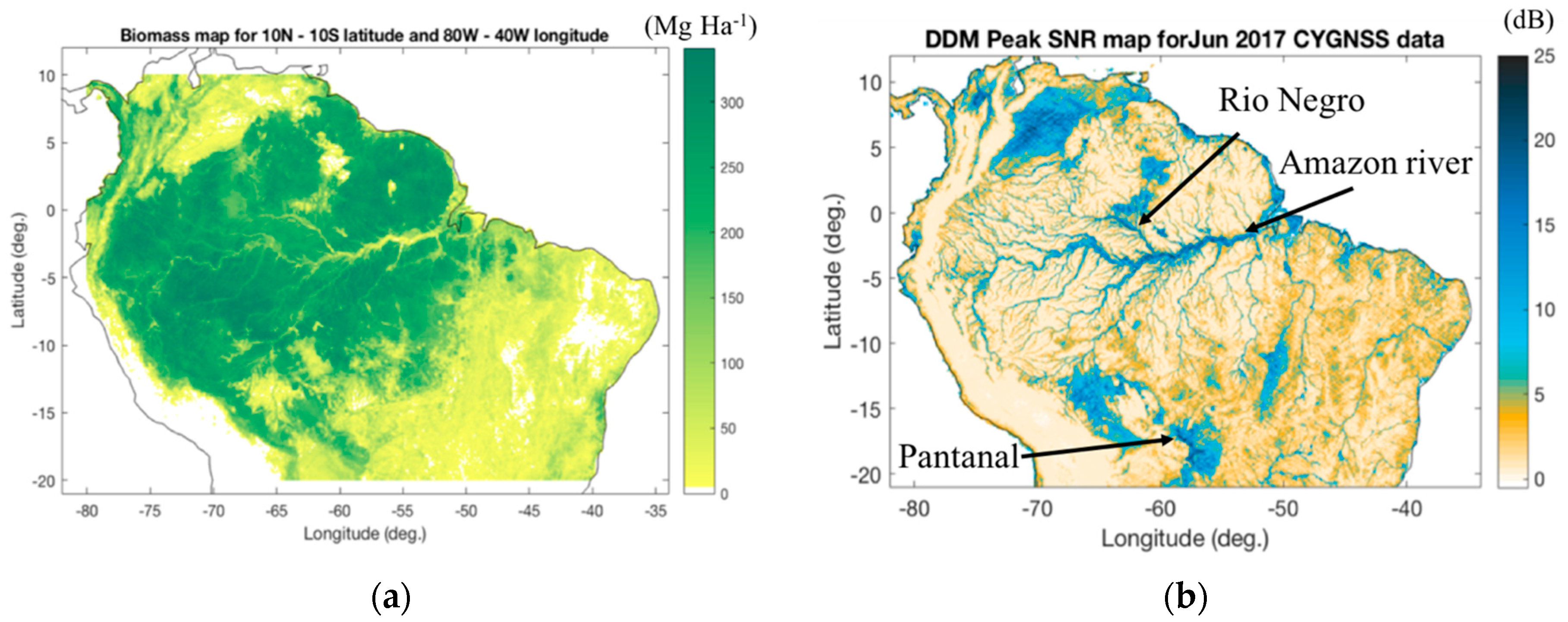
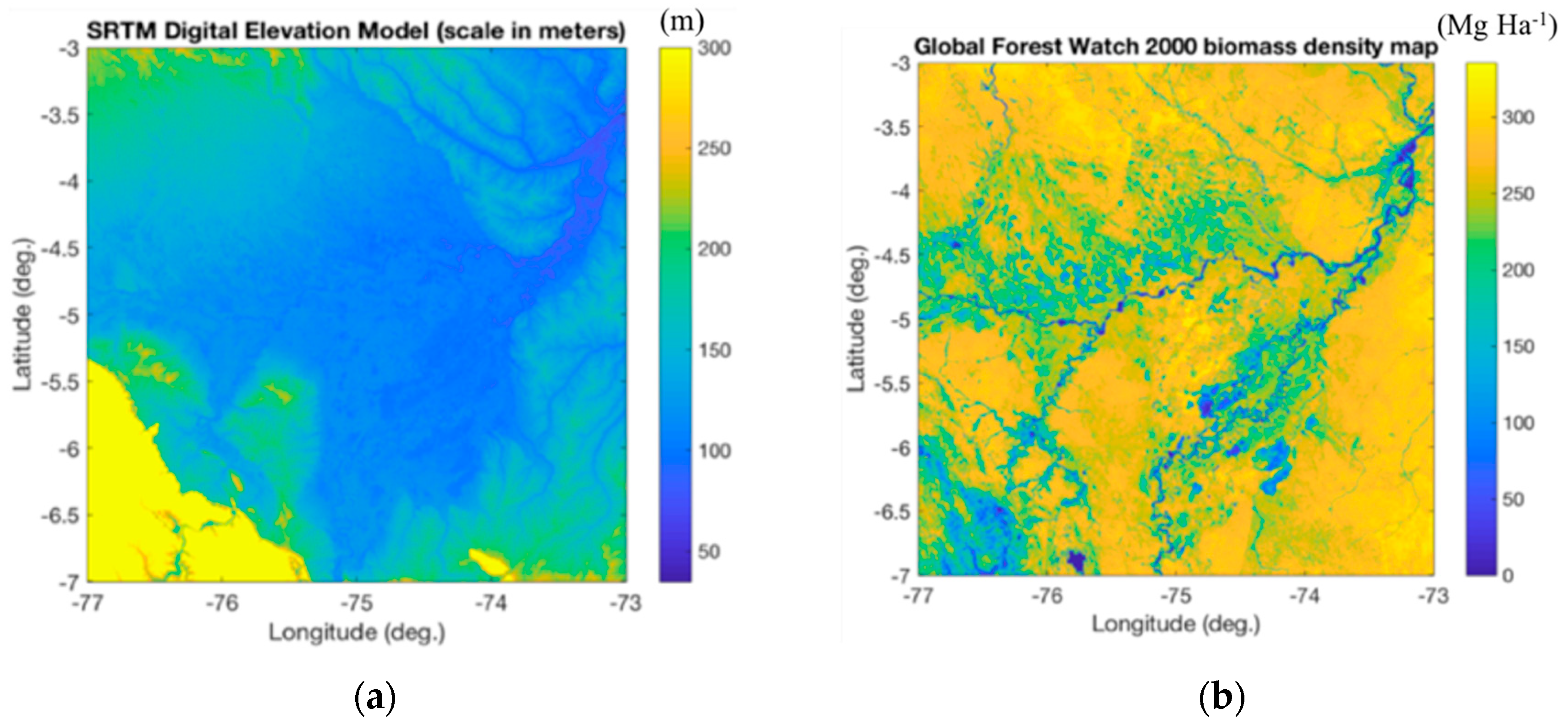
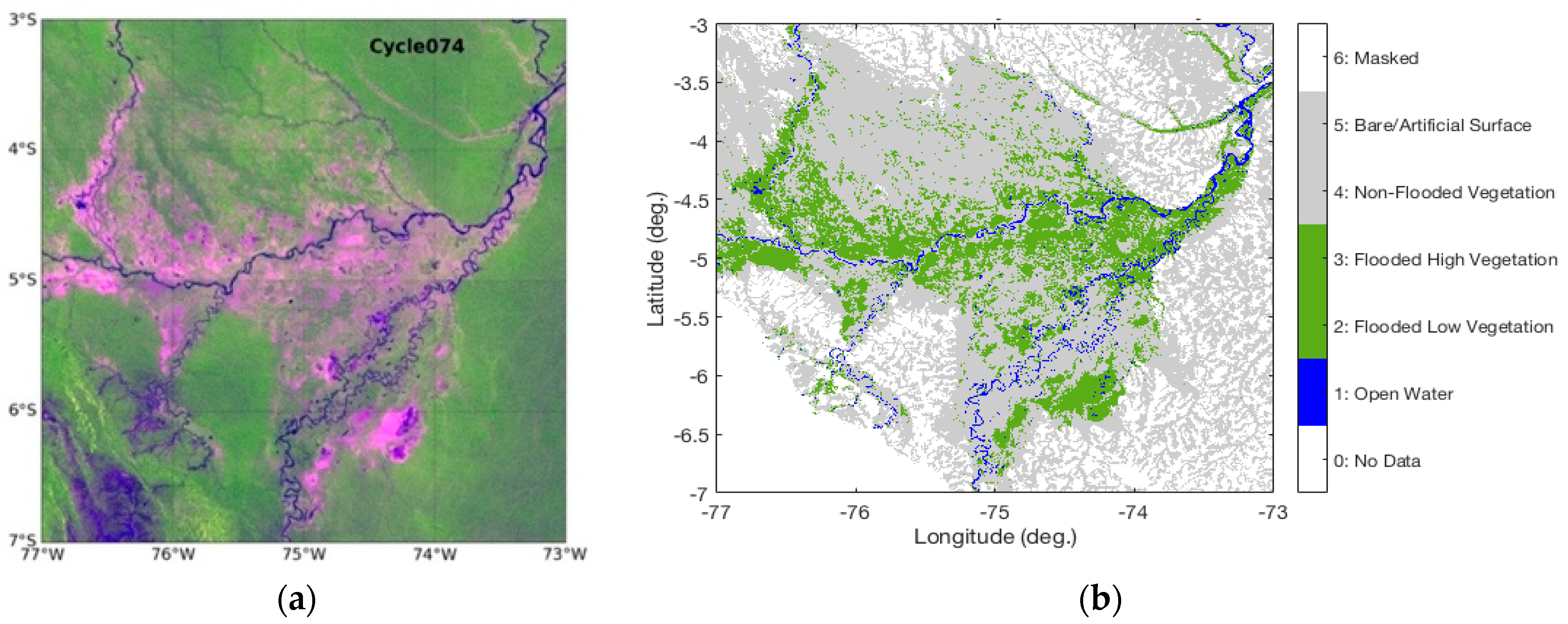
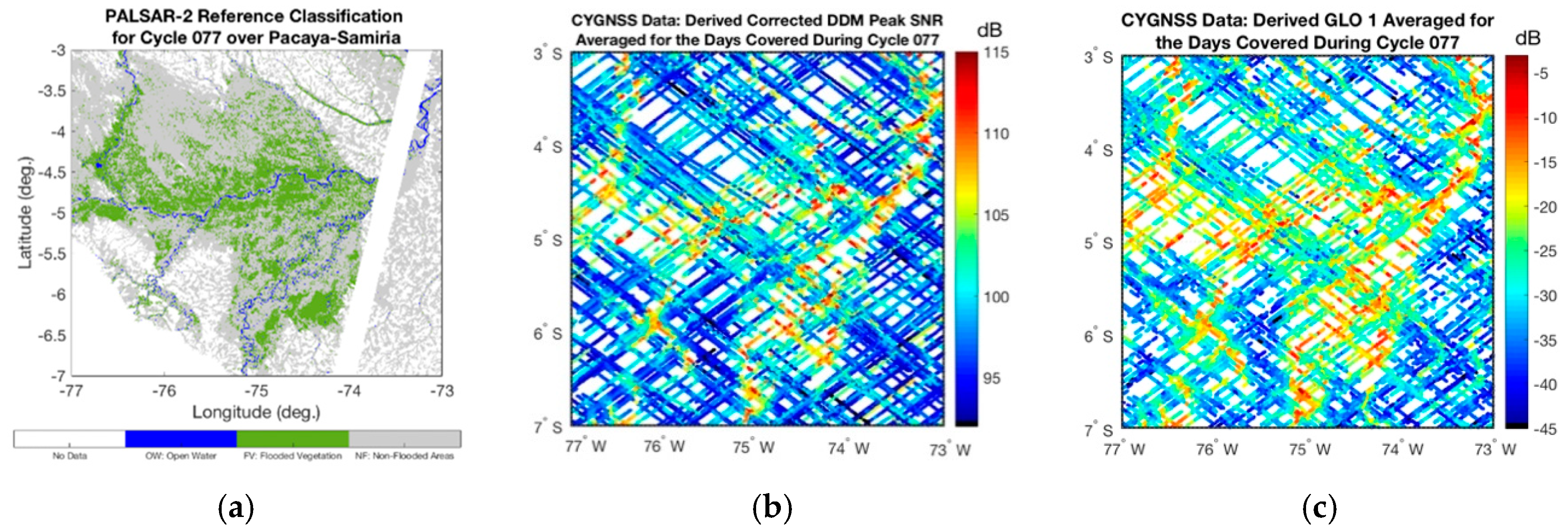
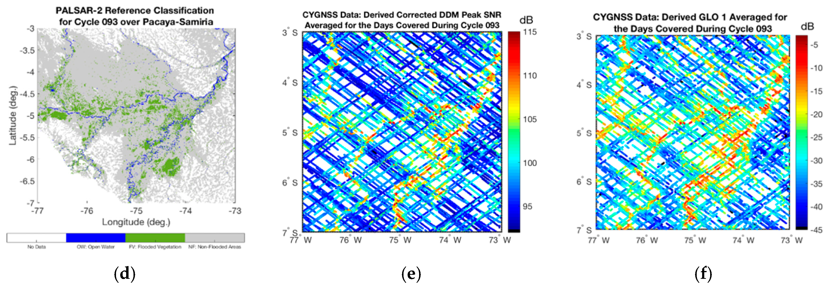
4.1. Datasets
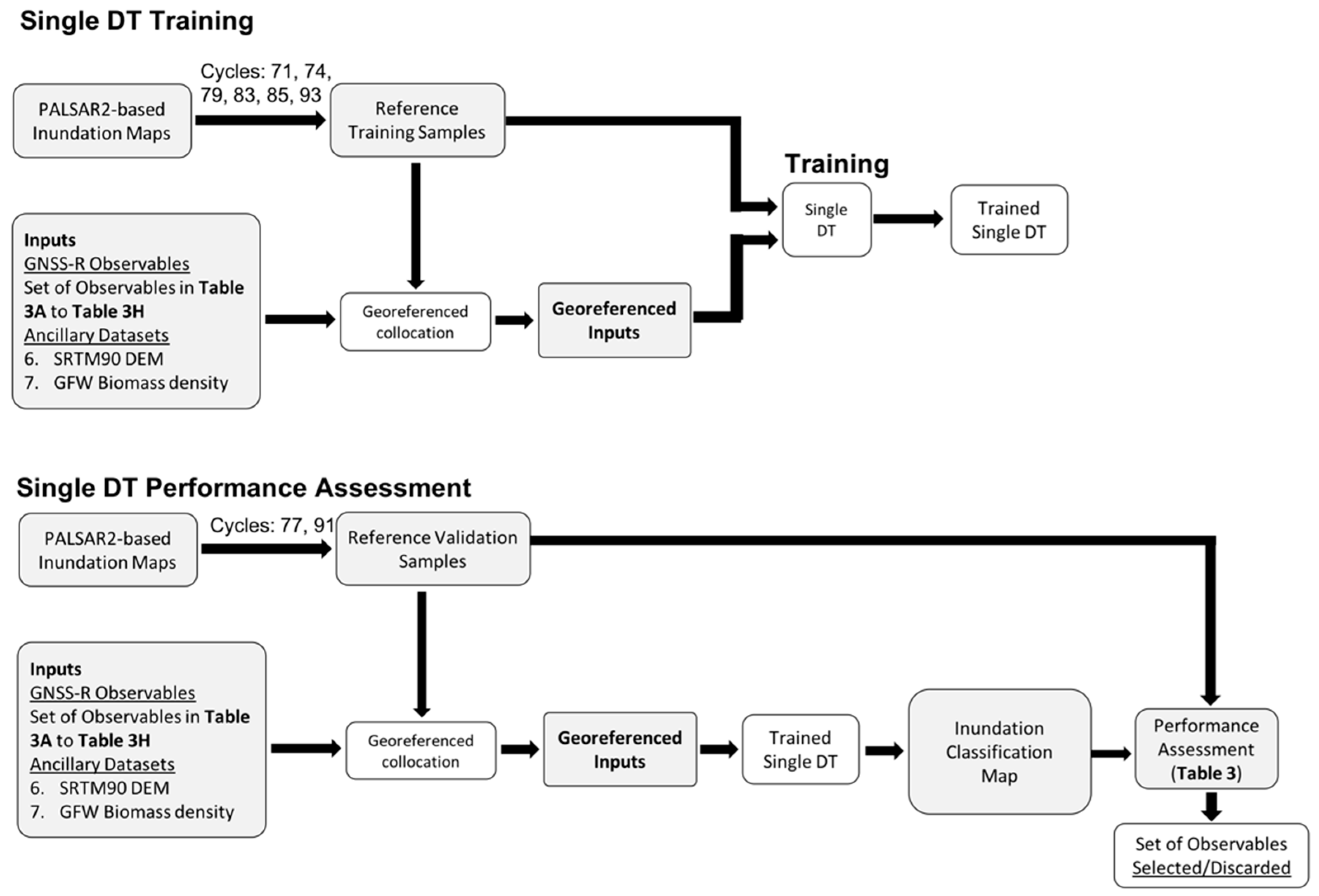
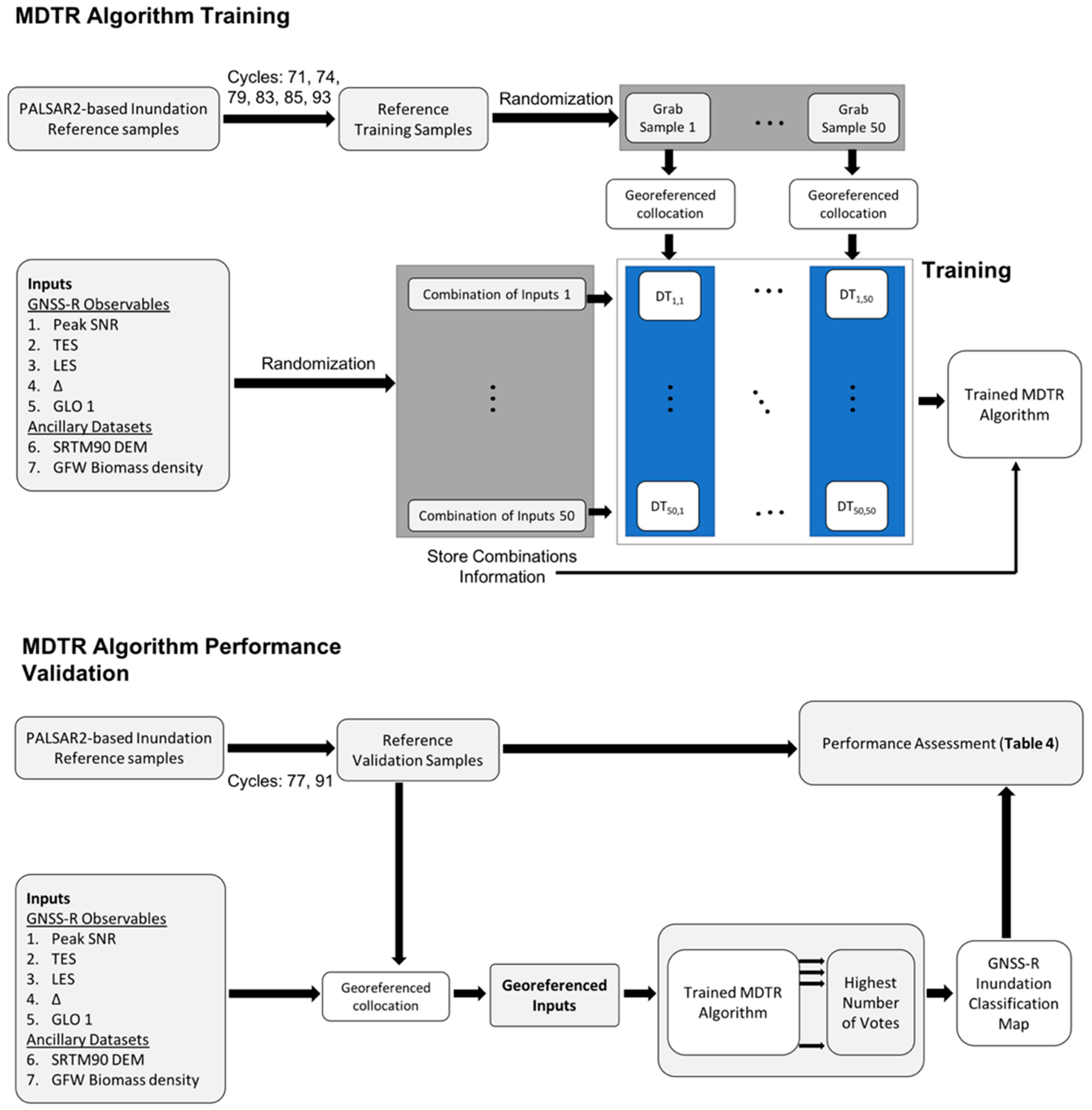
4.2. Algorithm Training
- The reference training samples (cycles 71, 74, 79, 83, 85, and 93 of the PALSAR-2-based inundation reference maps) are randomized in 50 grab samples (each containing 60% of the samples);
- The inputs (5 GNSS-R observables and 2 ancillary datasets) are randomized by selecting 50 different combinations;
- The different combinations of inputs are collocated to each one of the grab samples; and
- The reference grab samples and each combination of collocated inputs are used to train single decision trees (DT).
- Each single DT is based on a standard classification and regression tree (CART) approach for machine learning [54]. A total of 2500 single DT’s are generated, constituting the MDTR algorithm.
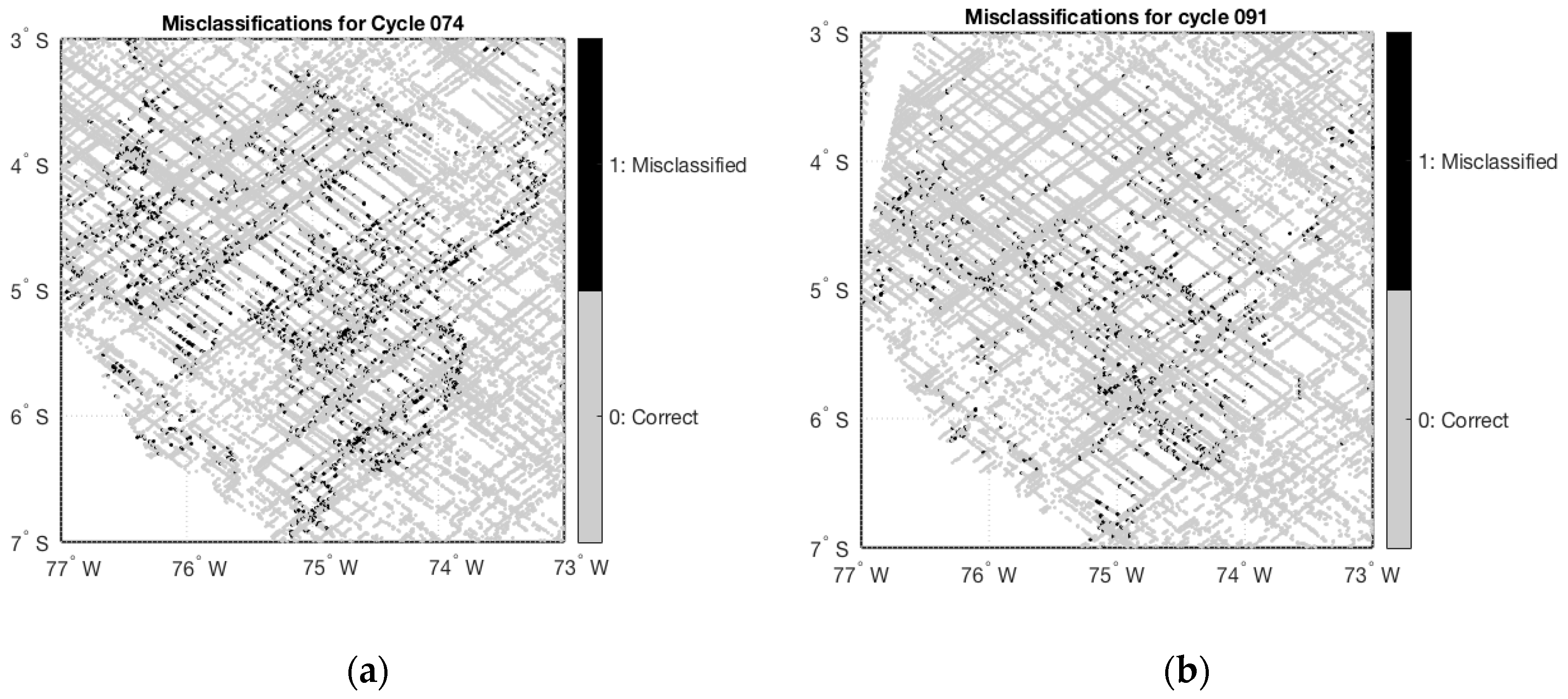
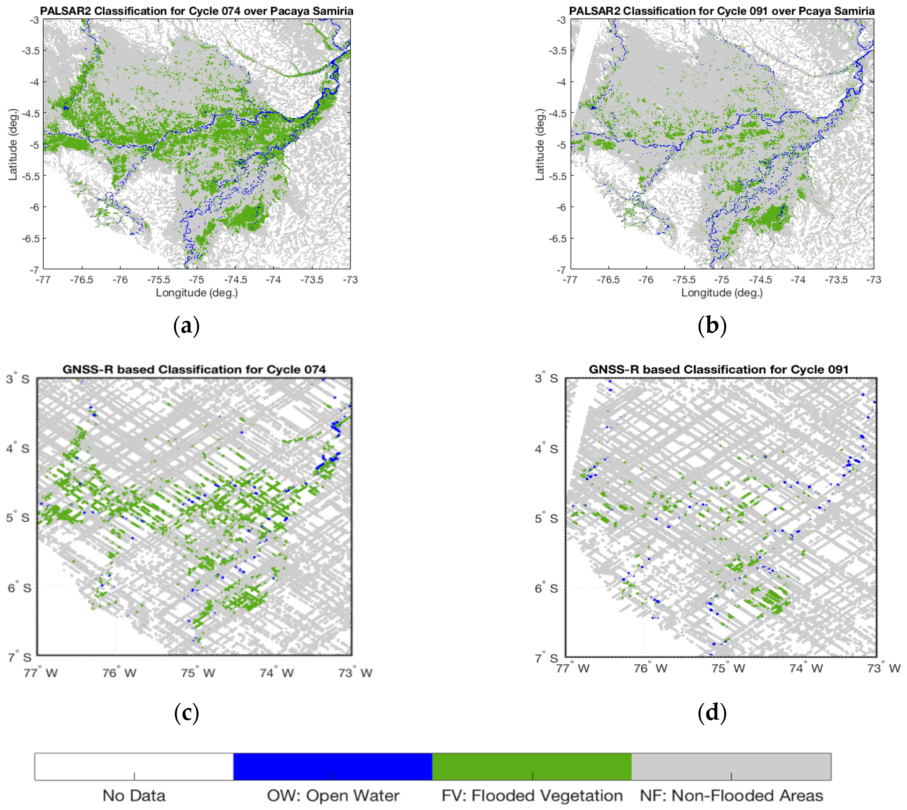
4.3. Performance Validation and Results
5. Discussion
6. Conclusions
Author Contributions
Funding
Acknowledgments
Conflicts of Interest
Appendix A. Additional CYGNSS Dataset Information

| Quality Flag | Flagged in Analysis |
|---|---|
| Poor Overall Quality | No |
| S Band Powered Up | Yes |
| Small Spacecraft Attitude Error | No |
| Large Spacecraft Attitude Error | Yes |
| Blackbody DDM | Yes |
| DDMI Reconfigured | Yes |
| Spacewire CRC Invalid | Yes |
| DDM is Test Patten | Yes |
| Channel Idle | Yes |
| Low Confidence DDM Noise Floor | No |
| SP Over Land | No |
| SP Very Near Land | No |
| SP Near Land | No |
| Large Step Noise Floor | No |
| Direct Signal in DDM | Yes |
| Low Confidence GPS EIRP Estimate | Yes |
| RFI Detected | Yes |
| BRCS DDM SP Bin Delay Error | No |
| BRCS DDM SP Bin Doppler Error | No |
| Negative BRCS Value Used for NRBCS | No |
| GPS PVT SP3 Error | No |
| SP Non Existent Error | Yes |
| BRCS LUT Range Error | No |
| Antenna Data LUT Range Error | No |
| Blackbody Framing Error | Yes |
| FSW Comp Shift Error | No |
References
- Matthews, E. Atmospheric Methane: Its Role in the Global Environment; Khalil, M.A.K., Ed.; Springer: Berlin, Germany, 2000; pp. 202–233. [Google Scholar]
- Ciais, P.; Sabine, C.; Bala, G.; Bopp, L.; Brovkin, V.; Canadell, J.; Chhabra, A.; DeFries, R.; Galloway, J.; Heimann, M.; et al. Carbon and Other Biogeochem Cycles. In Climate Change 2013: The Physical Science Basis; Stocker, T.F., Qin, D., Plattner, G.-K., Tignor, M., Allen, S.K., Boschung, J., Nauels, A., Xia, Y., Bex, V., Midgley, P.M., Eds.; Cambridge University Press: Cambridge, UK; New York, NY, USA, 2013. [Google Scholar]
- Nisbet, E.G.; Dlugokencky, E.J.; Bousquet, P. Methane on the rise—Again. Science 2014, 343, 493–495. [Google Scholar] [CrossRef]
- Page, S.E.; Rieley, J.O.; Banks, C.J. Global and regional importance of the tropical peatland carbon pool. Glob. Chang. Biol. 2011, 17, 798–818. [Google Scholar] [CrossRef] [Green Version]
- Bridgham, S.D.; Johnson, C.A.; Pastor, J.; Updegraff, K. Potential Feedbacks of northern wetlands to climate change. Bioscience 1995, 45, 262–274. [Google Scholar]
- Alsdorf, D.E.; Lettenmaier, D.P.; Vorosmarty, C.; The NASA Surface Water Working Group. The need for global, satellite-based observations of terrestrial surface waters. Eos Trans. AGU 2003, 84, 269–280. [Google Scholar] [CrossRef]
- Frankenberg, C.; Meirink, J.F.; van Weele, M.; Platt, U.; Wagner, T. Assessing methane emissions from global space-borne observations. Science 2005, 308, 1010–1014. [Google Scholar] [CrossRef] [PubMed]
- Prigent, C.; Papa, F.; Aires, F.; Rossow, W.B.; Matthews, E. Global inundation dynamics inferred from multiple satellite observations, 1993–2000. J. Geophys. Res. 2007, 112. [Google Scholar] [CrossRef] [Green Version]
- Schroeder, R.; McDonald, K.C.; Chapman, B.D.; Jensen, K.; Podest, E.; Tessler, Z.D.; Bohn, T.J.; Zimmermann, R. Development and evaluation of a multi-year fractional surface water data set derived from active/passive microwave remote sensing data. Remote Sens. 2015, 7, 16688–16732. [Google Scholar] [CrossRef]
- Jensen, K.; McDonald, K.; Podest, E.; Rodriguez-Alvarez, N.; Horna, V.; Steiner, N. Assessing L-band GNSS-reflectometry and imaging radar for detecting sub-canopy inundation dynamics in a tropical wetlands complex. Remote Sens. 2018, 10. [Google Scholar] [CrossRef]
- Di Vittorio, C.A.; Georgakakos, A.P. Land cover classification and wetland inundation mapping using MODIS. Remote Sens Environ. 2018, 204, 1–17. [Google Scholar] [CrossRef]
- Li, L.; Vrieling, A.; Skidmore, A.; Wang, T.; Munoz, A.-R.; Turak, E. Evaluation of modis spectral indices for monitoring hydrological dynamics of a small, seasonally-flooded wetland in southern Spain. Wetlands 2015, 35, 851–864. [Google Scholar] [CrossRef]
- Chen, Y.; Huang, C.; Ticehurst, C.; Merrin, L.; Thew, P. An evaluation of MODIS daily and 8-day composite products for floodplain and wetland inundation mapping. Wetlands 2013, 33, 823–835. [Google Scholar] [CrossRef]
- Touzi, R.; Deschamps, A.; Rother, G. Wetland characterization using polarimetric radarsat-2 capability. Can. J. Remote Sens. 2007, 33, S56–S67. [Google Scholar] [CrossRef]
- Hess, L.L.; Melack, J.M.; Simonett, D.S. Radar detection of flooding beneath the forest canopy: A review. Int. J. Remote Sens. 1990, 11, 1313–1325. [Google Scholar] [CrossRef]
- Gallant, A.L.; Kaya, S.G.; White, L.; Brisco, B.; Roth, M.F.; Sadinski, W.; Rover, J. Detecting emergence, growth, and senescence of wetland vegetation with polarimetric synthetic aperture radar (SAR) data. Water 2014, 6, 694–722. [Google Scholar] [CrossRef]
- White, L.; Brisco, B.; Pregitzer, M.; Tedford, B.; Boychuk, L. Radarsat-2 beam mode selection for surface water and flooded vegetation mapping. Can. J. Remote Sens. 2014, 40, 135–151. [Google Scholar]
- Chapman, B.; McDonald, K.; Shimada, M.; Rosenqvist, A.; Schroeder, R.; Hess, L. Mapping Regional Inundation with Spaceborne L-Band SAR. Remote Sens. 2015, 5, 5440–5470. [Google Scholar] [CrossRef]
- Papa, F.; Prigent, C.; Aires, F.; Jimenez, C.; Rossow, W.B.; Matthews, E. Interannual variability of surface water extent at the global scale, 1993–2004. J. Geophys. Res. 2010, 115. [Google Scholar] [CrossRef] [Green Version]
- Jensen, K.; McDonald, K.C. Surface water microwave product series (SWAMPS) version 3: A near-real time and 25-year historical global inundated area fraction time series from active and passive microwave remote sensing. IEEE Geosci. Remote Sens. Lett. 2019. [Google Scholar] [CrossRef]
- Lehner, B.; Doll, P. Development and validation of a global database of lakes, reservoirs and wetlands. J. Hydrol. 2004, 296, 1–22. [Google Scholar] [CrossRef]
- Brakenridge, R.; Anderson, E. MODIS-based flood detection, mapping and measurement: The potential for operational hydrological applications. Transbound. Floods Reduc. Risks Through Flood Manag. 2006. [Google Scholar] [CrossRef]
- Hess, L.L.; Melack, J.M.; Novo, E.M.; Barbosa, C.C.; Gastil, M. Dual-season mapping of wetland inundation and vegetation for the central Amazon basin. Remote Sens. Environ. 2003, 87, 404–428. [Google Scholar] [CrossRef]
- Betbeder, J.; Gond, V.; Frappart, F.; Bagdhadi, N.; Briant, G.; Bartholomé, E. Mapping of Central Africa Forested Wetlands Using Remote Sensing. IEEE J. Sel. Top. Appl. Earth Obs. Remote Sens. 2014, 7, 531–542. [Google Scholar] [CrossRef] [Green Version]
- Le Toan, T.; Ribbes, F.; Wang, L.; Floury, N.; Ding, K.H.; Kong, J.A.; Fujita, N.; Kurosu, T. Rice crop mapping and monitoring using ERS-1 data based on experiment and modeling results. IEEE Trans. Geosci. Remote Sens. 1997, 35, 41–56. [Google Scholar] [CrossRef]
- Wang, Y.; Weinacker, H.; Koch, B. A LIDAR point cloud-based procedure for vertical canopy structure analysis and 3D single tree modelling in forest. Sensors 2008, 8, 3938–3951. [Google Scholar] [CrossRef]
- Chapman, B.; Celi, J.; Hamilton, S.; McDonald, K. Validation of forested inundation extent revealed by L-band polarimetric and interferometric SAR data. In Proceedings of the International Geoscience and Remote Sensing Society Symposium, Quebec, Canada, 13–18 July 2014. [Google Scholar]
- Ruf, C.S.; Gleason, S.; Jelenak, Z.; Katzberg, S.; Ridley, A.; Rose, R.; Scherrer, J.; Zavorotny, V.U. The CYGNSS nanosatellite constellation hurricane mission. In Proceedings of the 2012 IEEE International Geoscience and Remote Sensing Symposium, Munich, Germany, 22–27 July 2012; pp. 214–216. [Google Scholar]
- Ruf, C.; Unwin, M.; Dickinson, J.; Rose, R.; Rose, D.; Vincent, M.; Lyons, A. CYGNSS: Enabling the Future of Hurricane Prediction [Remote Sensing Satellites]. IEEE Geosci. Remote Sens. Mag. 2013, 1, 52–67. [Google Scholar] [CrossRef]
- Nghiem, S.V.; Zuffada, C.; Shah, R.; Chew, C.; Lowe, S.T.; Mannucci, A.J.; Cardellach, E.; Brakenridge, G.R.; Geller, G.; Rosenqvist, A. Wetland monitoring with global navigation satellite system reflectometry. Earth Space Sci. 2016, 4, 16–39. [Google Scholar] [CrossRef]
- Foti, G.; Gommenginger, C.; Jales, P.; Unwin, M.; Shaw, A.; Robertson, C.; Rosello, J. Spaceborne gnss reflectometry for ocean winds: First results from the UK TechDemosat-1 mission. Geophys. Res. Lett. 2015, 42, 5435–5441. [Google Scholar] [CrossRef]
- Zuffada, C.; Chew, C.; Nghiem, S.V. Global navigation satellite system reflectometry (GNSS-R) algorithms for wetland observations. In Proceedings of the 2017 IEEE International Geoscience and Remote Sensing Symposium (IGARSS), Fort Worth, TX, USA, 23–28 July 2017; pp. 1126–1129. [Google Scholar]
- Chew, C.; Reager, J.T.; Small, E. CYGNSS data map flood inundation during the 2017 Atlantic hurricane season. Sci. Rep. 2018. [Google Scholar] [CrossRef]
- Wan, W.; Liu, B.; Zeng, Z.; Chen, X.; Wu, G.; Xu, L.; Chen, X.; Hong, Y. Using CYGNSS data to monitor China’s flood inundation during typhoon and extreme precipitation events in 2017. Remote Sens. 2019, 11. [Google Scholar] [CrossRef]
- Rosenqvist, A.; Shimada, M.; Suzuki, S.; Ohgushi, F.; Tadono, T.; Watanabe, M.; Tsuzuku, K.; Watanabe, T.; Kamijo, S.; Aoki, E. Operational performance of the ALOS global systematic acquisition strategy and observation plans for ALOS-2 PALSAR-2. Remote Sens. Environ. 2014, 155, 3–12. [Google Scholar] [CrossRef]
- Zavorotny, V.U.; Voronovich, A.G. Scattering of GPS signals from the ocean with wind remote sensing application. IEEE Trans. Geosci. Remote Sens. 2000, 38, 951–964. [Google Scholar] [CrossRef]
- Voronovich, A.G.; Zavorotny, V.U. Bistatic radar equation for signals of opportunity revisited. IEEE Trans. Geosci. Remote Sens. 2018, 56, 1959–1968. [Google Scholar] [CrossRef]
- Weiqiang, L.; Cardellach, E.; Fabra, F.; Rius, A.; Ribó, S.; Martín-Neira, M. First spaceborne phase altimetry over sea ice using TechDemoSat-1 GNSS-R signals. Geophys. Res. Lett. 2017, 44, 8369–8376. [Google Scholar] [CrossRef]
- Loria, E.; O’Brien, A.; Gupta, I.J. Detection & Separation of Coherent Reflections in GNSS-R Measurements Using CYGNSS Data. In Proceedings of the IGARSS 2018—2018 IEEE International Geoscience and Remote Sensing Symposium, Valencia, Greece, 22–27 July 2018; pp. 3995–3998. [Google Scholar]
- Roo, R.D.D.; Ulaby, F.T. Bistatic specular scattering from rough dielectric surfaces. IEEE Trans. Antennas Propag. 1994, 42, 220–231. [Google Scholar] [CrossRef]
- Ulaby, F.T.; Long, D.G. Microwave Radar and Radiometric Remote Sensing; University of Michigan Press: Michigan, MI, USA, 2014. [Google Scholar]
- Beckmann, P.; Spizzichino, A.E. The Scattering of Electromagnetic Waves from Rough Surfaces; Pergamon Press: Oxford, UK, 1963. [Google Scholar]
- Ghasemi, A.; Abedi, A.; Ghasemi, F. Propagation Engineering in Wireless Communications; Springer: New York, NY, USA, 2011. [Google Scholar]
- Ruf, C.; Scherrer, J.; Rose, R.; Provost, D. Algorithm Theoretical Basis Document Level 1B DDM Calibration. Tech. Rep. 2014. Available online: https://clasp-research.engin.umich.edu/missions/cygnss/reference/ATBD%20L1B%20DDM%20Calibration%20R1.pdf (accessed on 3 May 2018).
- GlobalForestWatch. Global Forest Watch Aboveground Live Woody Biomass Density Dataset. Available online: http://data.globalforestwatch.org/datasets/8f93a6f94a414f9588ce4657a39c59ff_1 (accessed on 3 May 2018).
- Rodriguez-Alvarez, N.; Akos, D.M.; Zavorotny, V.U.; Smith, J.A.; Camps, A.; Fairall, C.W. Airborne GNSS-R Wind Retrievals Using Delay–Doppler Maps. IEEE Trans. Geosci. Remote Sens. 2013, 51, 626–641. [Google Scholar] [CrossRef]
- Carreno-Luengo, H.; Lowe, S.; Zuffada, C.; Esterhuizen, S.; Oveisgharan, S. Spaceborne GNSS-R from the SMAP mission: first assessment of polarimetric scatterometry over land and cryosphere. Remote Sens. 2017, 9. [Google Scholar] [CrossRef]
- Weiqiang, L.; Cardellach, E.; Fabra, F.; Ribó, S.; Rius, A. Effects of PRN-dependent ACF deviations on GNSS-R wind speed retrieval. IEEE Geosci. Remote Sens. Lett. 2019, 16, 327–331. [Google Scholar]
- Rodriguez-Alvarez, N.; Garrison, J.L. Generalized linear observables for ocean wind retrieval from calibrated GNSS-R delay-doppler maps. IEEE Trans. Geosci. Remote Sens. 2016, 54, 1142–1155. [Google Scholar] [CrossRef]
- Breiman, L. Random forests. Mach. Learn. 2001, 45, 5–32. [Google Scholar] [CrossRef]
- NASA Shuttle Radar Topography Mission Global 3 arc second [Data set]. NASA EOSDIS Land Process. DAAC 2013. [CrossRef]
- Mukul, M.; Srivastava, V.; Mukul, M. Analysis of the accuracy of Shuttle Radar Topography Mission (SRTM) height models using International Global Navigation Satellite System Service (IGS) Network. J. Earth Syst. Sci. 2015, 124, 1343–1357. [Google Scholar] [CrossRef]
- Ballhorn, U.; Juvanski, J.; Siegert, F. ICESat/GLAS data as a measurement tool for peatland topography and peat swamp forest biomass in kalimantan, Indonesia. Remote Sens. 2011, 3, 1957–1982. [Google Scholar] [CrossRef]
- Breiman, L.; Friedman, J.; Olshen, R.; Stone, C. Classification and Regression Trees; CRC Press: Florida, FL, USA, 1984. [Google Scholar]


| Delay Bin () | |||
|---|---|---|---|
| m − 3 | 0.0503 | −0.2030 | 0.4353 |
| m − 2 | 0.2125 | −0.4267 | 0.3853 |
| m − 1 | 0.4725 | −0.5186 | 0.0541 |
| M | 0.6625 | −0.0366 | −0.3698 |
| m + 1 | 0.4933 | 0.5582 | −0.0212 |
| m + 2 | 0.2089 | 0.4072 | 0.4479 |
| m + 3 | 0.0575 | 0.1706 | 0.5669 |
| Cycle | Start Date | End Date |
|---|---|---|
| 071 | Mar. 27, 2017 | Apr. 09, 2017 |
| 074 | May 08, 2017 | May 21, 2017 |
| 077 | Jun. 19, 2017 | Jul. 02, 2017 |
| 079 | Jul. 17, 2017 | Jul. 30, 2017 |
| 082 | Aug. 28, 2017 | Sep. 10, 2017 |
| 085 | Oct. 09, 2017 | Oct. 22, 2017 |
| 088 | Nov. 20, 2017 | Dec. 03, 2017 |
| 091 | Jan. 01, 2018 | Jan. 14, 2018 |
| 093 | Feb. 12, 2018 | Feb. 25, 2018 |
| GNSS-R Class | OW | FV | NF | |||
|---|---|---|---|---|---|---|
| # | Inputs | PALSAR-2 Class | ||||
| A | corrected peak SNR + SRTM90 DEM + GFW biomass density | OW | 58.87% | 18.14% | 22.99% | |
| FV | 1.83% | 53.87% | 44.30% | |||
| NF | 0.42% | 5.95% | 93.63% | |||
| B | TES + SRTM90 DEM + GFW biomass density | OW | 63.08% | 15.22% | 21.69% | |
| FV | 1.81% | 55.37% | 42.82% | |||
| NF | 0.34% | 6.01% | 93.64% | |||
| C | corrected peak SNR + TES + SRTM90 DEM + GFW biomass density | OW | 64.21% | 14.94% | 20.85% | |
| FV | 1.81% | 58.98% | 39.21% | |||
| NF | 0.42% | 5.82% | 93.76% | |||
| D | corrected peak SNR + TES + SRTM90 DEM | OW | 46.76% | 16.78% | 36.44% | |
| FV | 1.92% | 62.58% | 35.48% | |||
| NF | 0.51% | 5.28% | 94.20% | |||
| E | corrected peak SNR + TES + GFW biomass density | OW | 60.26% | 14.96% | 24.78% | |
| FV | 2.52% | 58.39% | 39.09% | |||
| NF | 0.41% | 5.53% | 94.06% | |||
| F | corrected peak SNR + TES + LES + ∆ + GLO 1 + SRTM90 DEM + GFW biomass density | OW | 65.40% | 13.98% | 20.62% | |
| FV | 1.76% | 60.26% | 37.98% | |||
| NF | 0.30% | 4.95% | 94.75% | |||
| G | corrected peak SNR + TES + LES + ∆ + GLO 1 + GLO 2 + SRTM90 DEM + GFW biomass density | OW | 59.11% | 11.12% | 29.77% | |
| FV | 1.45% | 30.26% | 68.29% | |||
| NF | 0.27% | 2.26% | 97.47% | |||
| H | corrected peak SNR + TES + LES + ∆ + GLO 1 + GLO 3 + SRTM90 DEM + GFW biomass density | OW | 54.21% | 22.07% | 23.72% | |
| FV | 1.40% | 50.03% | 48.57% | |||
| NF | 0.31% | 4.23% | 95.46% | |||
| GNSS-R Class | OW | FV | NF | |
|---|---|---|---|---|
| PALSAR-2 Class | ||||
| OW | 86.53% | 1.22% | 12.25% | |
| FV | 0.23% | 69.14% | 30.63% | |
| NF | 0.02% | 0.22% | 99.76% | |
© 2019 by the authors. Licensee MDPI, Basel, Switzerland. This article is an open access article distributed under the terms and conditions of the Creative Commons Attribution (CC BY) license (http://creativecommons.org/licenses/by/4.0/).
Share and Cite
Rodriguez-Alvarez, N.; Podest, E.; Jensen, K.; McDonald, K.C. Classifying Inundation in a Tropical Wetlands Complex with GNSS-R. Remote Sens. 2019, 11, 1053. https://doi.org/10.3390/rs11091053
Rodriguez-Alvarez N, Podest E, Jensen K, McDonald KC. Classifying Inundation in a Tropical Wetlands Complex with GNSS-R. Remote Sensing. 2019; 11(9):1053. https://doi.org/10.3390/rs11091053
Chicago/Turabian StyleRodriguez-Alvarez, Nereida, Erika Podest, Katherine Jensen, and Kyle C. McDonald. 2019. "Classifying Inundation in a Tropical Wetlands Complex with GNSS-R" Remote Sensing 11, no. 9: 1053. https://doi.org/10.3390/rs11091053
APA StyleRodriguez-Alvarez, N., Podest, E., Jensen, K., & McDonald, K. C. (2019). Classifying Inundation in a Tropical Wetlands Complex with GNSS-R. Remote Sensing, 11(9), 1053. https://doi.org/10.3390/rs11091053