High Temporal Resolution Monitoring of Suspended Matter Changes from GOCI Measurements in Lake Taihu

 ,
,  ,
, 
Abstract
1. Introduction
2. Materials and Methods
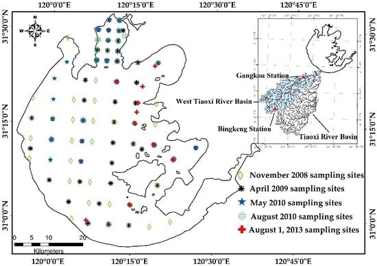
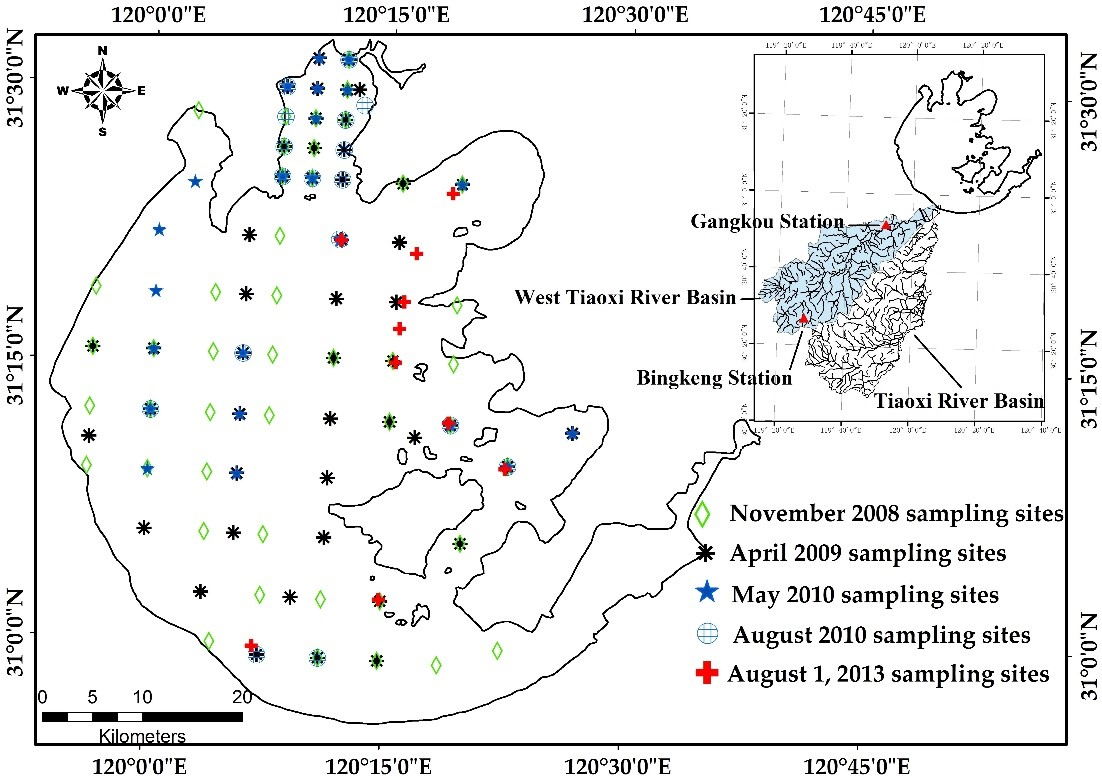
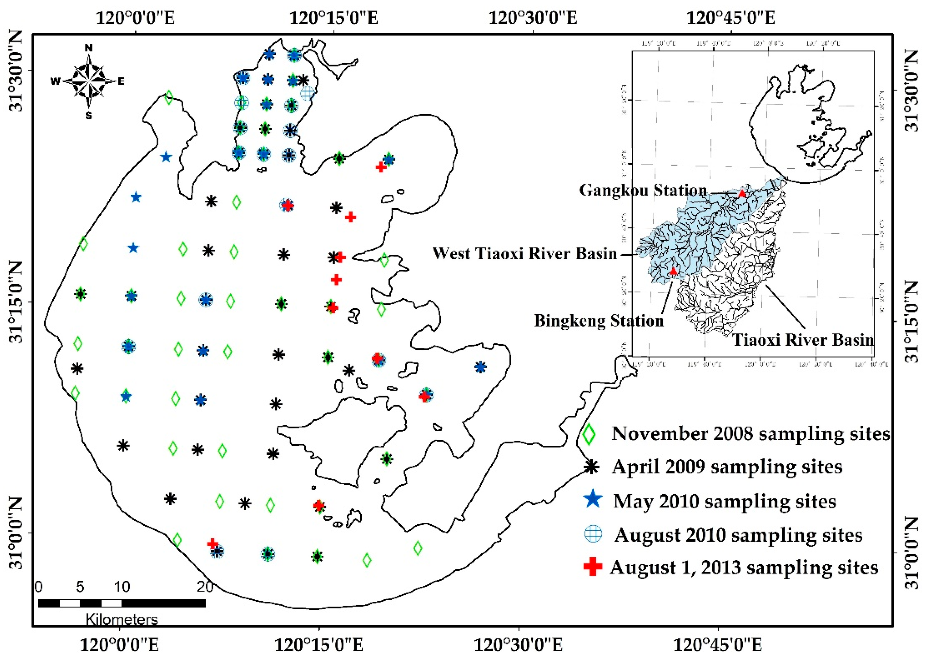
2.1. Study Area
2.2. GOCI Image Acquisition and Preprocessing
2.3. Field Data Collection
2.3.1. Measurement of Water Quality Parameters
2.3.2. Remote Sensing Reflectance Measurement
2.4. Hydrological and Meteorological Data
2.5. Statistical Analysis and Accuracy Assessment
3. Results
3.1. In Situ Measured TSM Distribution
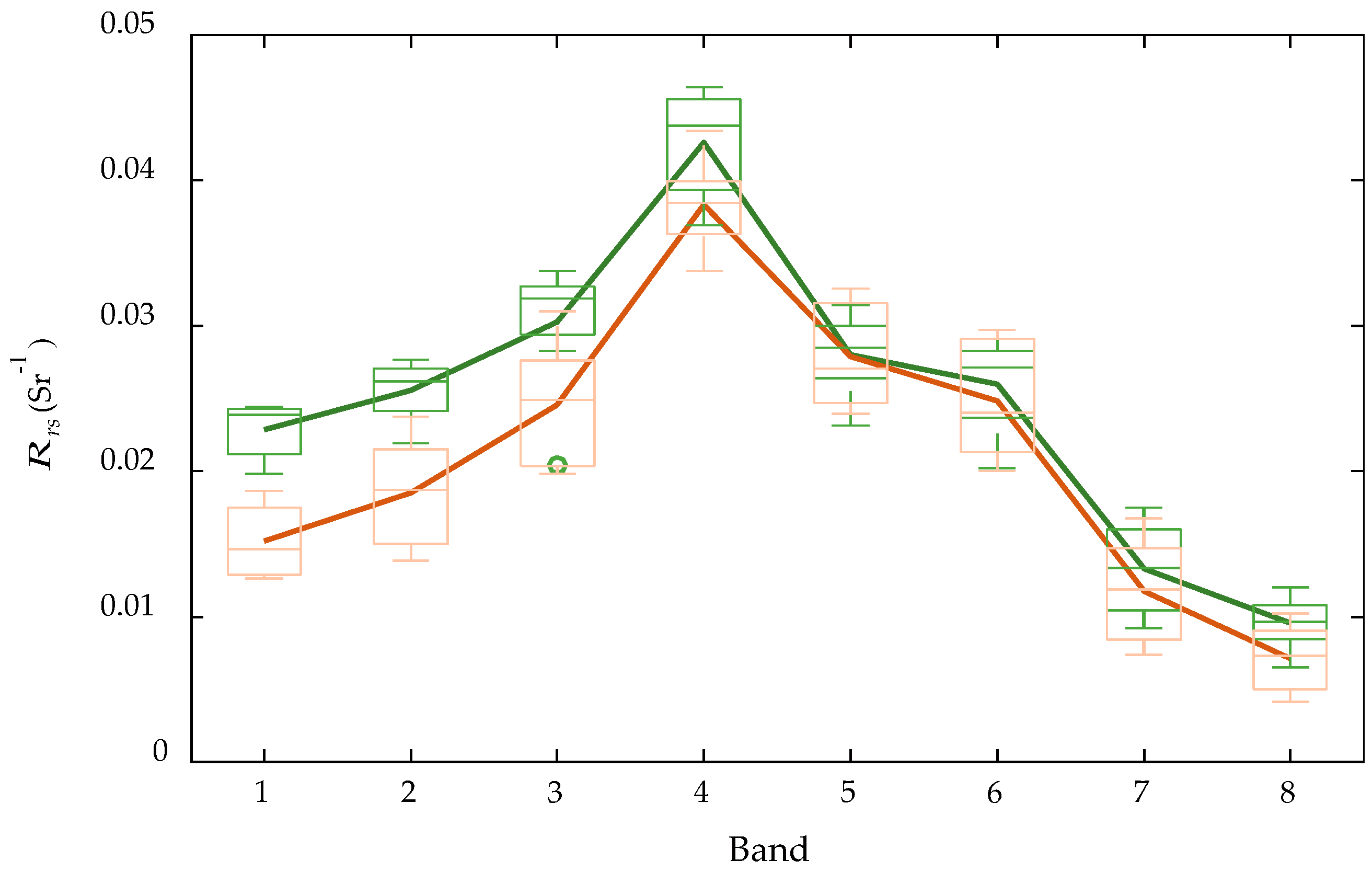
3.2. Analysis of Atmospheric Correction Results
3.3. Algorithm Development and Validation of GOCI Data
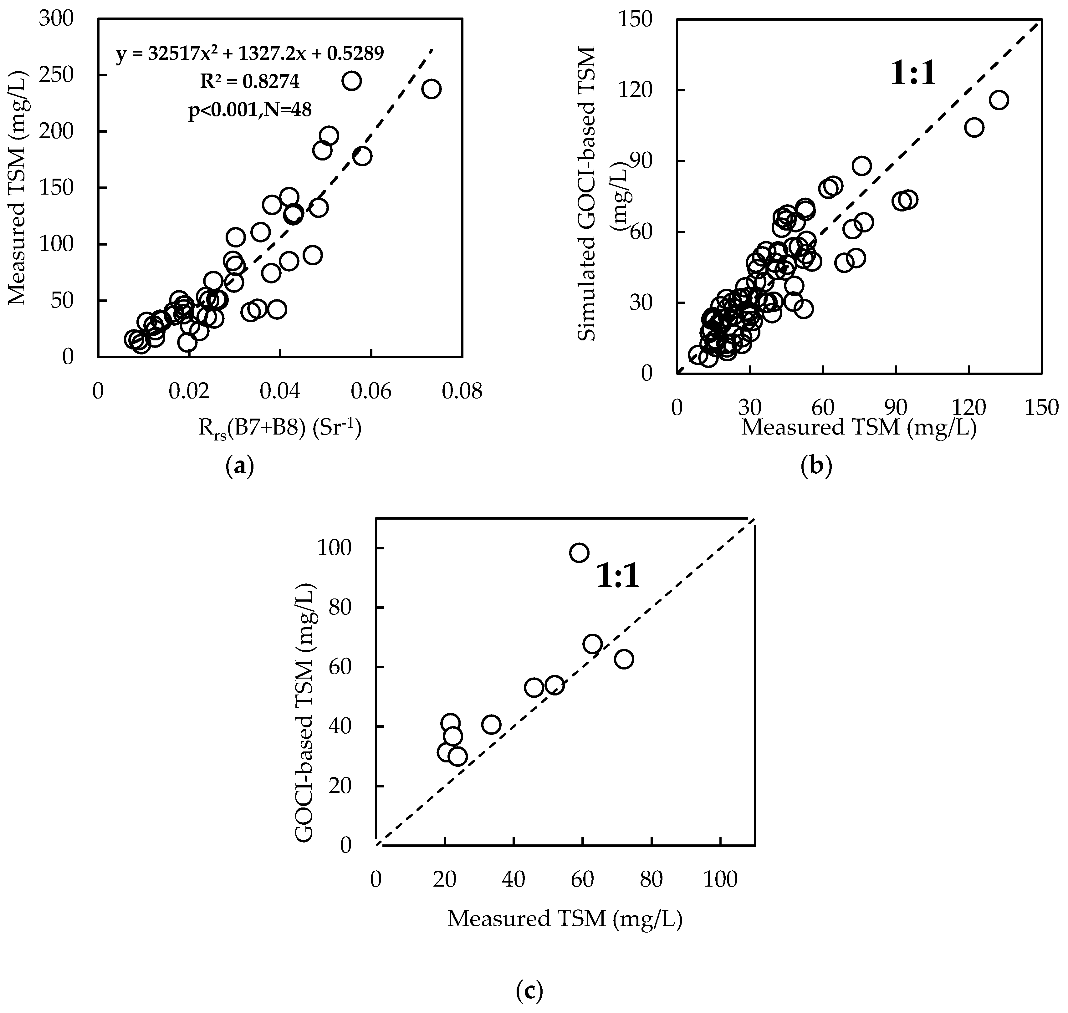
3.3.1. Development and Validation of the TSM Model
3.3.2. Validation of the GOCI-Based TSM Model
3.4. Spatial Distribution of TSM
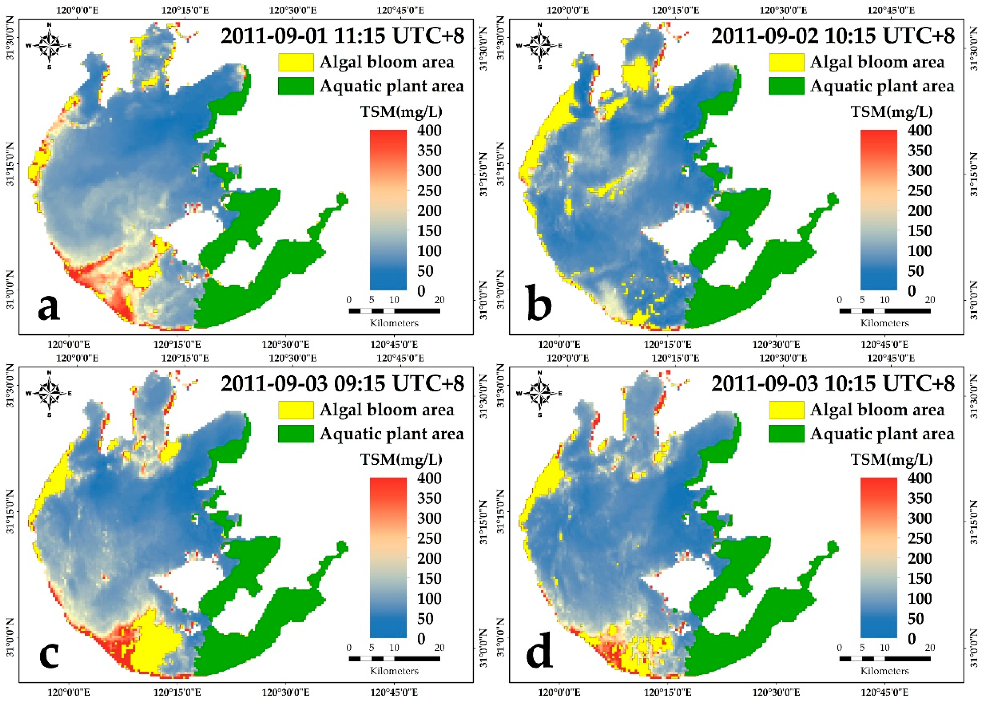
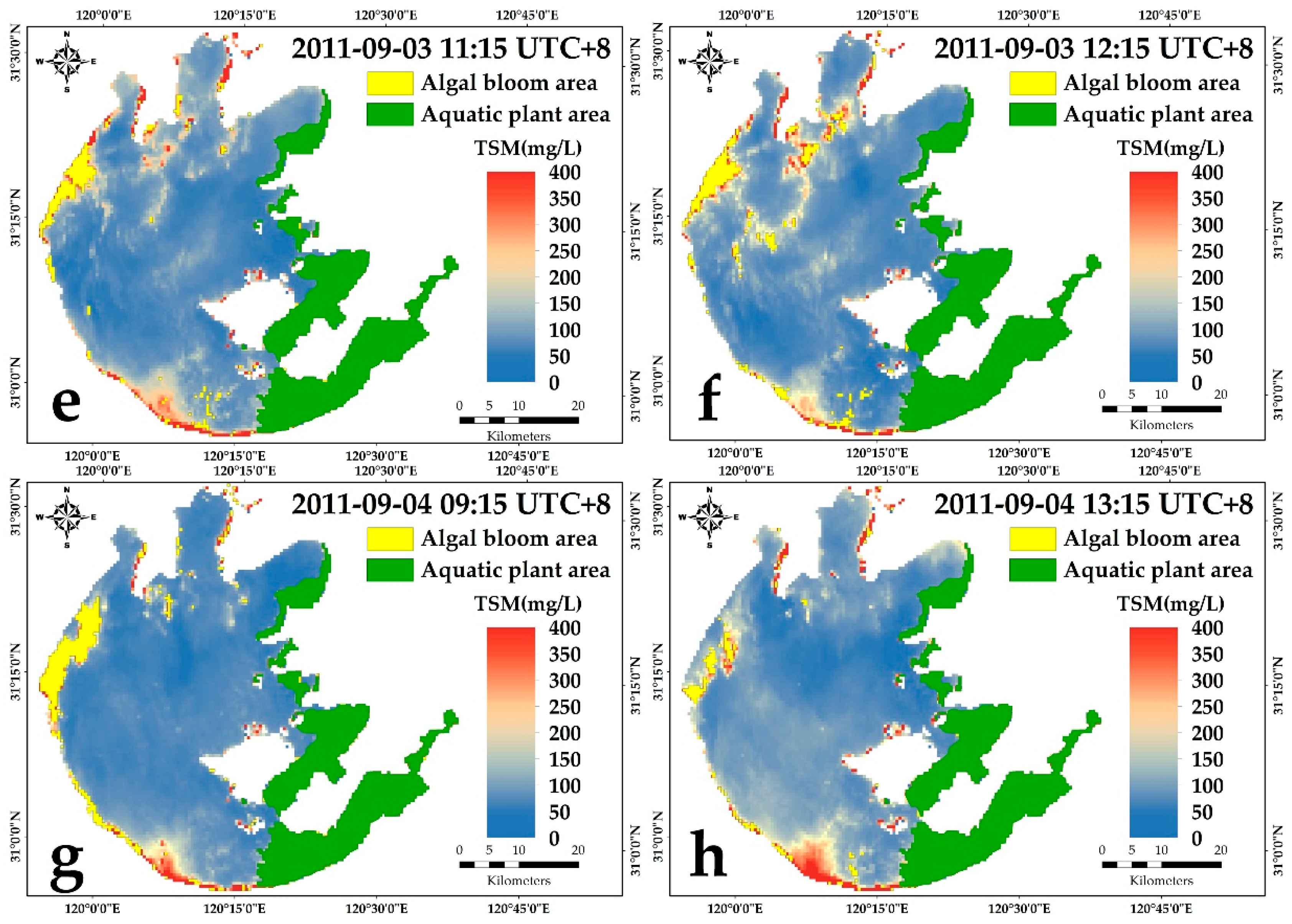
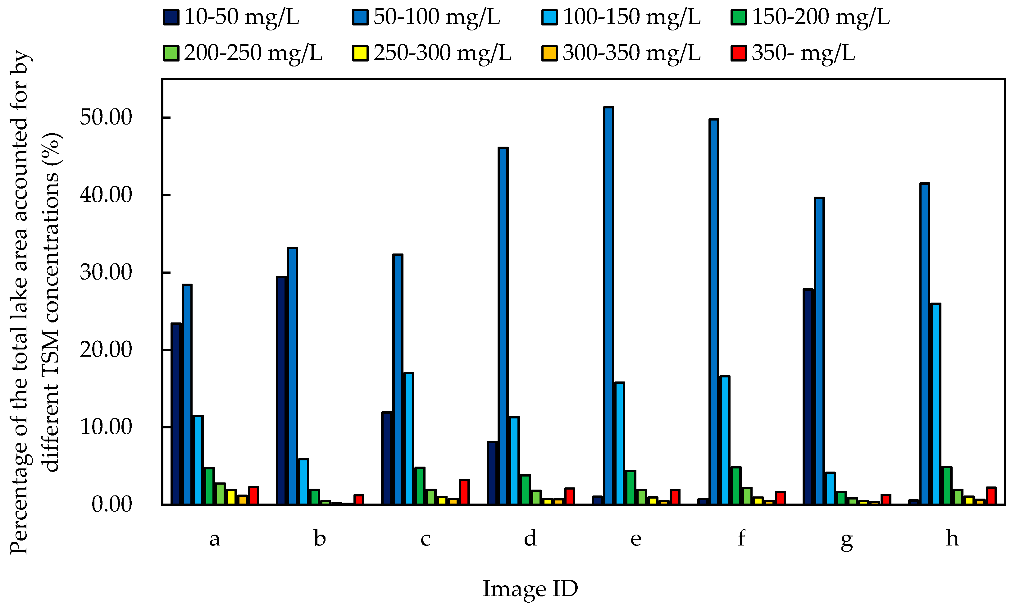
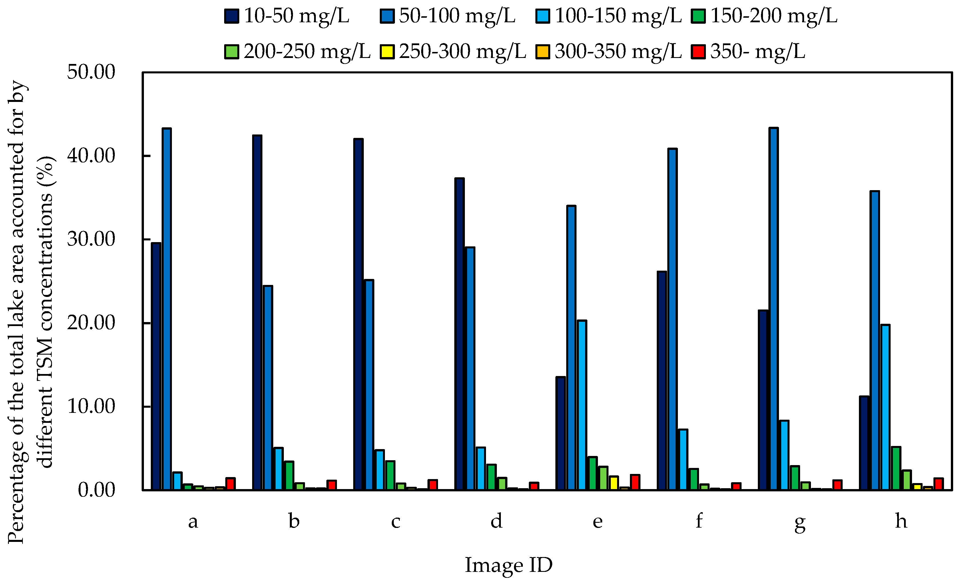
3.4.1. Spatial Pattern Distribution of TSM after Heavy Precipitation in August 2011
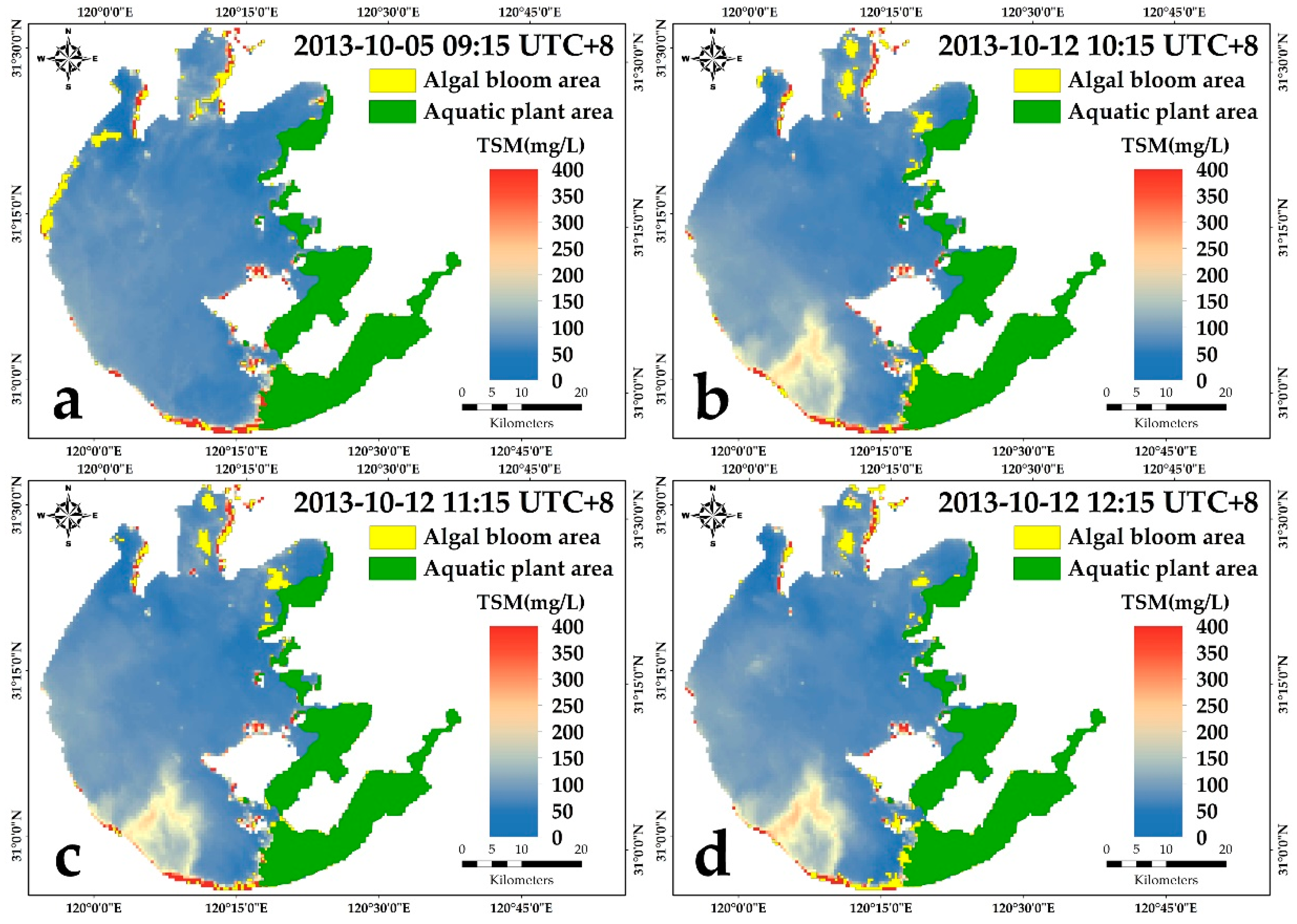
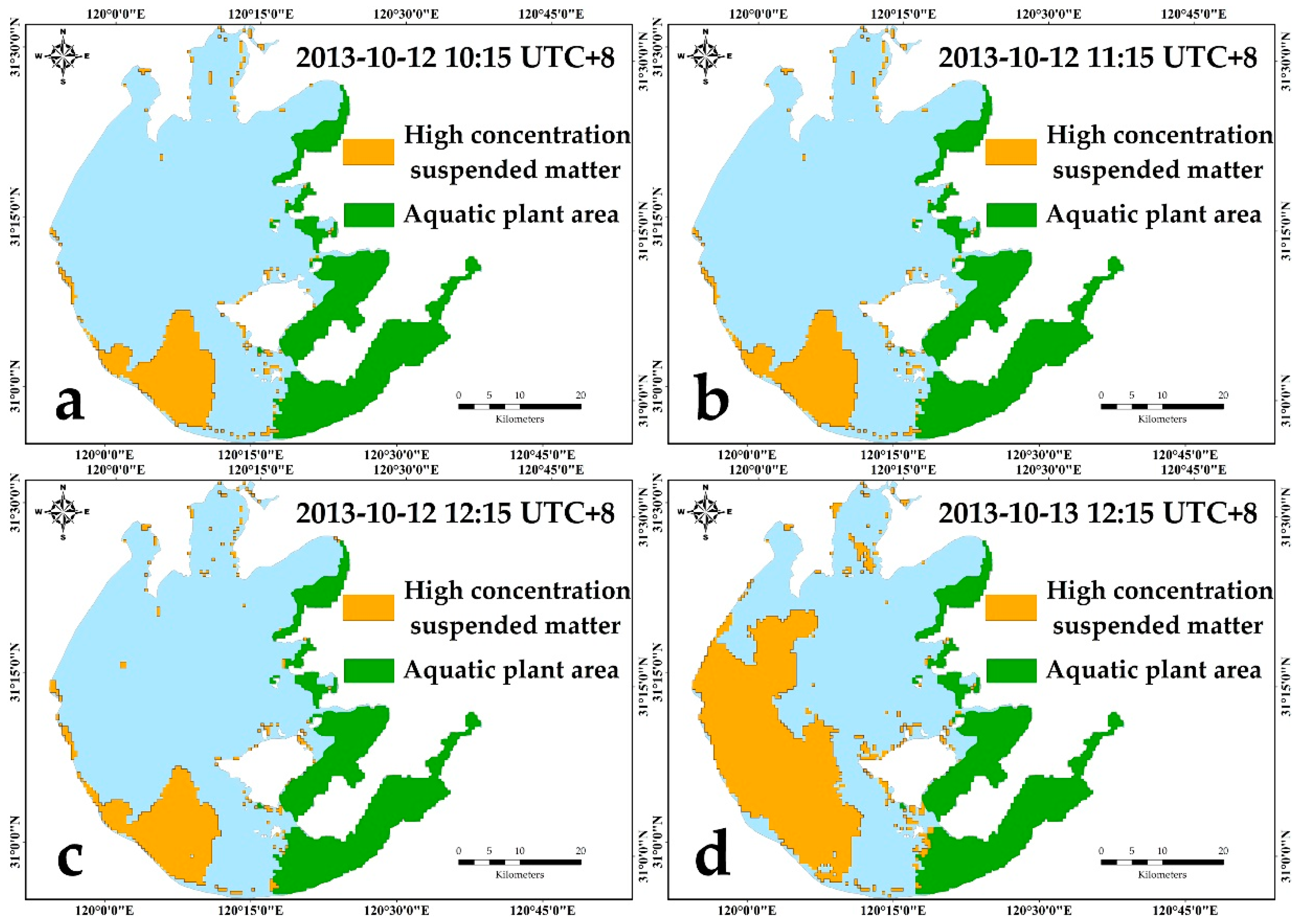
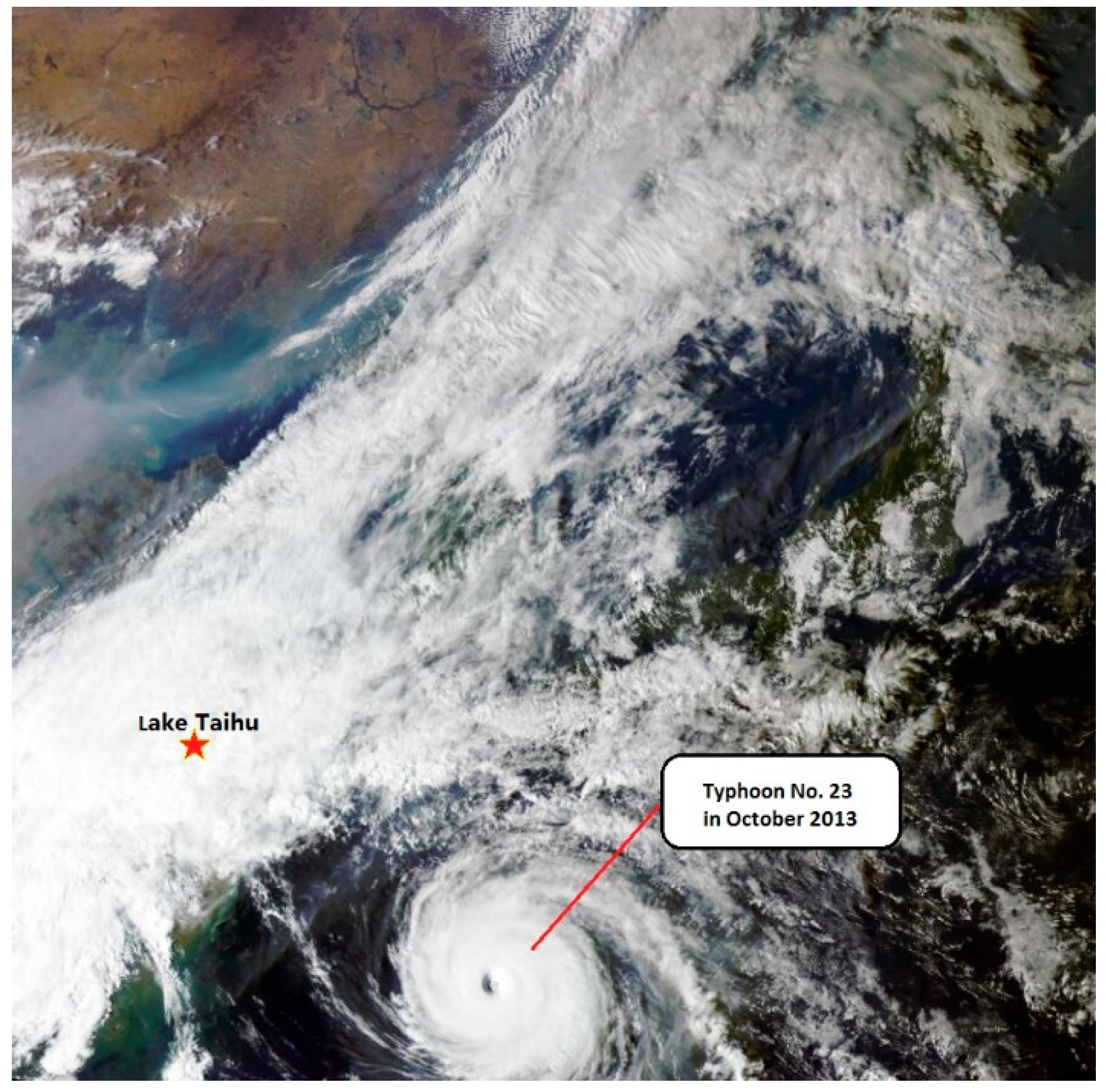
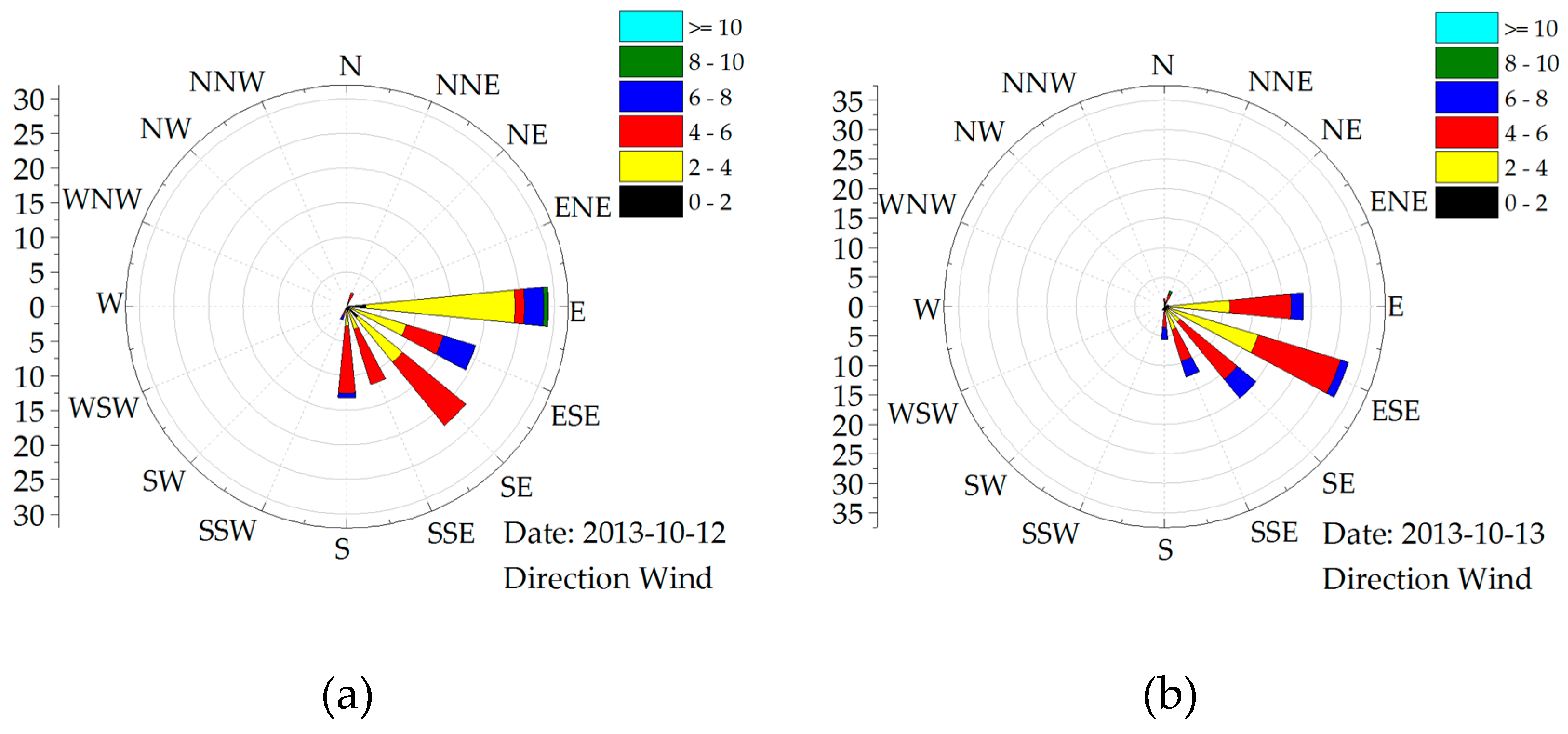
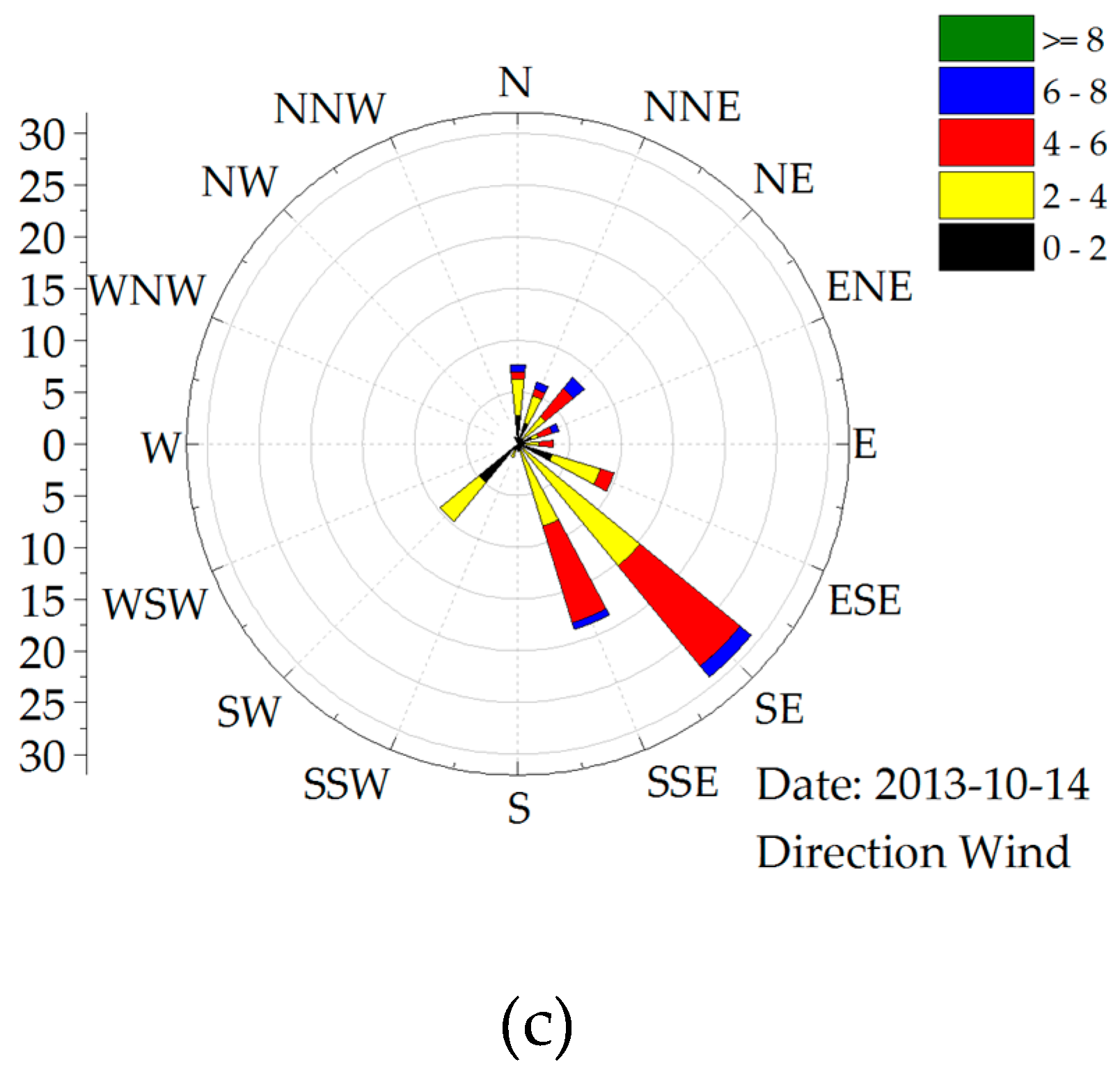
3.4.2. Spatial Distribution Patterns of TSM after Heavy Precipitation in October 2013
4. Discussion
4.1. The Use of High Temporal Resolution Satellites to Monitor the Diffusion of Matter in Inland Waters
4.2. Analysis of the Factors Influencing Plume Diffusion
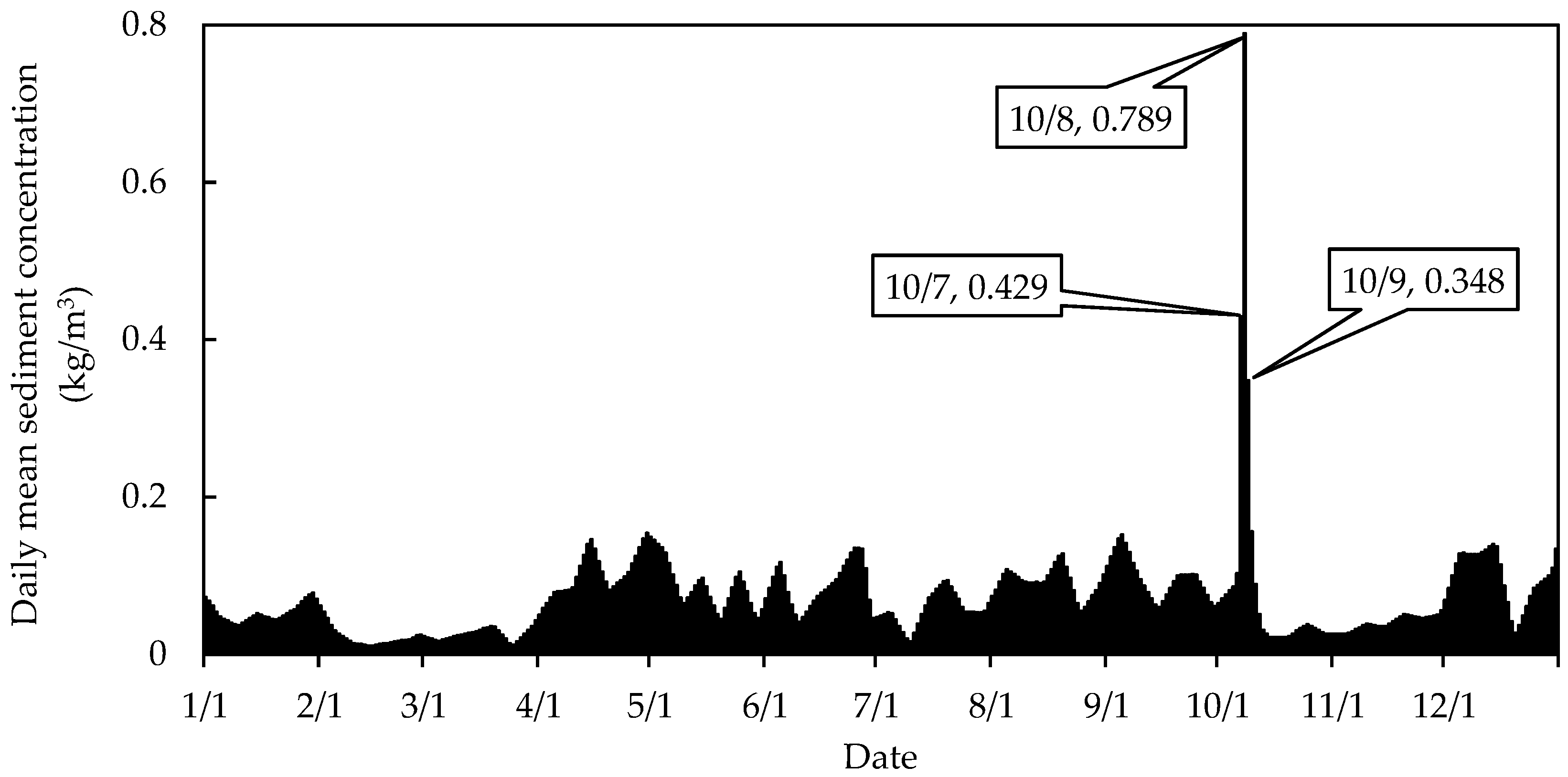
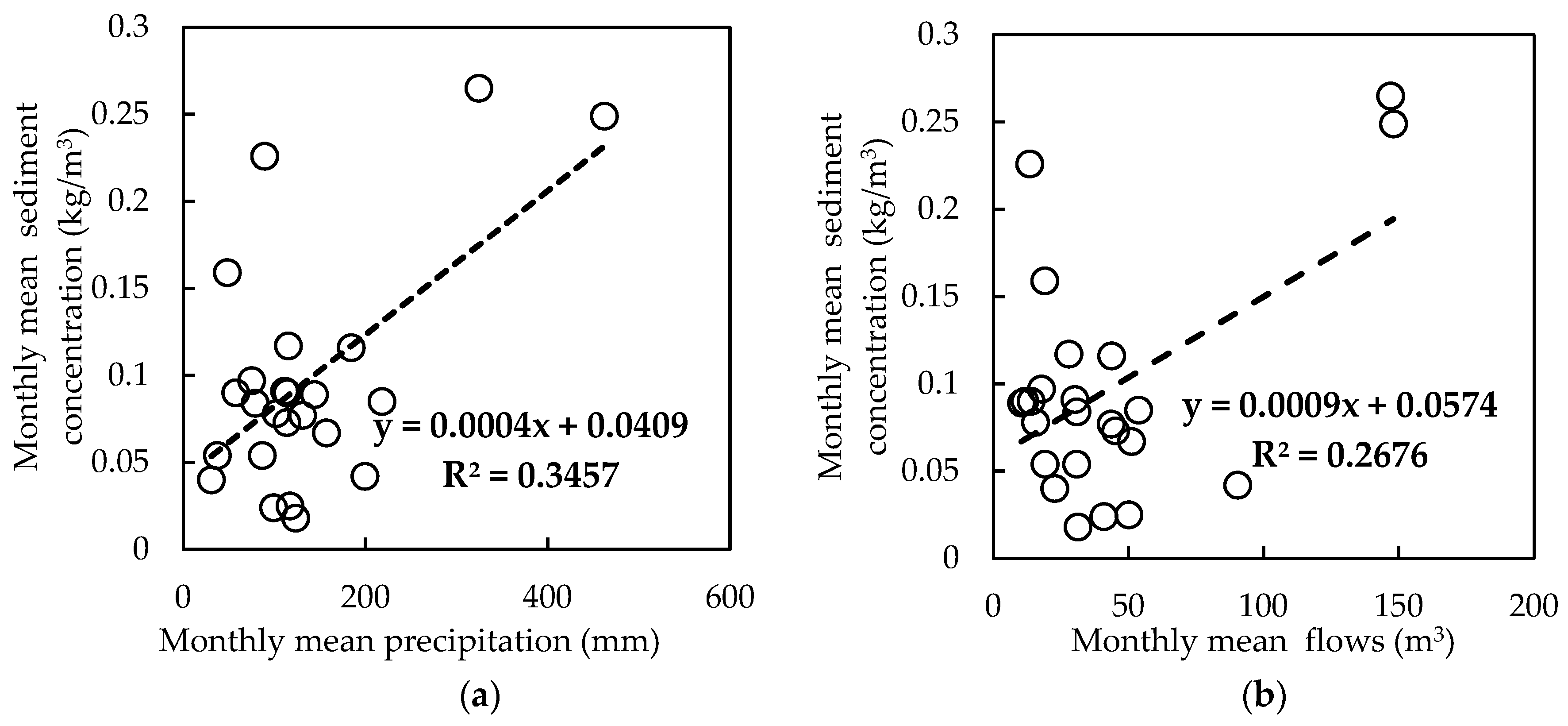
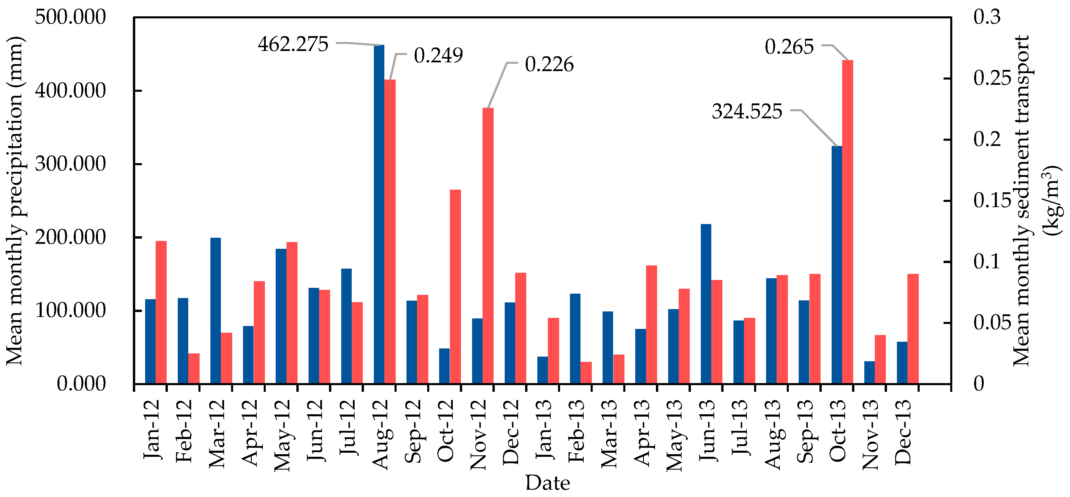
4.3. Analysis of the Relationship Between Precipitation and River Sediment Discharge
4.4. Implication for Water Resources Management
5. Conclusions
Author Contributions
Funding
Acknowledgments
Conflicts of Interest
References
- Devlin, M.; Petus, C.; Da Silva, E.; Tracey, D.; Wolff, N.; Waterhouse, J.; Brodie, J. Water quality and river plume monitoring in the Great Barrier Reef: an overview of methods based on ocean colour satellite data. Remote Sens. 2015, 7, 12909–12941. [Google Scholar] [CrossRef]
- He, X.; Bai, Y.; Pan, D.; Huang, N.; Dong, X.; Chen, J.; Chen, C.-T.A.; Cui, Q. Using geostationary satellite ocean color data to map the diurnal dynamics of suspended particulate matter in coastal waters. Remote Sens. Environ. 2013, 133, 225–239. [Google Scholar] [CrossRef]
- Ibánhez, J.S.P.; Diverrès, D.; Araujo, M.; Lefèvre, N. Seasonal and interannual variability of sea-air CO2 fluxes in the tropical Atlantic affected by the Amazon River plume. Global Biogeochem. Cy. 2015, 29, 1640–1655. [Google Scholar] [CrossRef]
- Molleri, G.S.F.; Kampel, M.; de Moraes Novo, E.M.L. Spectral classification of water masses under the influence of the Amazon River plume. Acta Oceanol. Sin. 2010, 29, 1–8. [Google Scholar] [CrossRef]
- Yuan, D.; Yang, G.-P.; He, Z. Spatio-temporal distributions of chlorofluorocarbons and methyl iodide in the Changjiang (Yangtze River) estuary and its adjacent marine area. Mar. Pollut. Bull. 2016, 103, 247–259. [Google Scholar] [CrossRef] [PubMed]
- Bonvin, F.; Rutler, R.; Chevre, N.; Halder, J.; Kohn, T. Spatial and temporal presence of a wastewater-derived micropollutant plume in Lake Geneva. Environ. Sci. Technol. 2011, 45, 4702–4709. [Google Scholar] [CrossRef]
- Tan, J.; Cherkauer, K.A.; Chaubey, I.; Troy, C.D.; Essig, R. Water quality estimation of River plumes in Southern Lake Michigan using Hyperion. J. Great Lakes Res. 2016, 42, 524–535. [Google Scholar] [CrossRef]
- Zhang, Y.; Shi, K.; Zhou, Y.; Liu, X.; Qin, B. Monitoring the river plume induced by heavy rainfall events in large, shallow, Lake Taihu using MODIS 250 m imagery. Remote Sens. Environ. 2016, 173, 109–121. [Google Scholar] [CrossRef]
- Brando, V.; Braga, F.; Zaggia, L.; Giardino, C.; Bresciani, M.; Matta, E.; Bellafiore, D.; Ferrarin, C.; Maicu, F.; Benetazzo, A. High-resolution satellite turbidity and sea surface temperature observations of river plume interactions during a significant flood event. Ocean Sci. 2015, 11, 909–920. [Google Scholar] [CrossRef]
- Petus, C.; Chust, G.; Gohin, F.; Doxaran, D.; Froidefond, J.-M.; Sagarminaga, Y. Estimating turbidity and total suspended matter in the Adour River plume (South Bay of Biscay) using MODIS 250-m imagery. Cont. Shelf Res. 2010, 30, 379–392. [Google Scholar] [CrossRef]
- Salisbury, J.; Vandemark, D.; Campbell, J.; Hunt, C.; Wisser, D.; Reul, N.; Chapron, B. Spatial and temporal coherence between Amazon River discharge, salinity, and light absorption by colored organic carbon in western tropical Atlantic surface waters. J. Geophys. Res. Oceans 2011, 116. [Google Scholar] [CrossRef]
- Matthews, M.W. A current review of empirical procedures of remote sensing in inland and near-coastal transitional waters. Int. J. Remote Sens. 2011, 32, 6855–6899. [Google Scholar] [CrossRef]
- Wang, M.; Shi, W.; Tang, J. Water property monitoring and assessment for China’s inland Lake Taihu from MODIS-Aqua measurements. Remote Sens. Environ. 2011, 115, 841–854. [Google Scholar] [CrossRef]
- Koponen, S.; Pulliainen, J.; Kallio, K.; Hallikainen, M. Lake water quality classification with airborne hyperspectral spectrometer and simulated MERIS data. Remote Sens. Environ. 2002, 79, 51–59. [Google Scholar] [CrossRef]
- Tebbs, E.; Remedios, J.; Harper, D. Remote sensing of chlorophyll-a as a measure of cyanobacterial biomass in Lake Bogoria, a hypertrophic, saline–alkaline, flamingo lake, using Landsat ETM+. Remote Sens. Environ. 2013, 135, 92–106. [Google Scholar] [CrossRef]
- Bergamino, N.; Horion, S.; Stenuite, S.; Cornet, Y.; Loiselle, S.; Plisnier, P.-D.; Descy, J.-P. Spatio-temporal dynamics of phytoplankton and primary production in Lake Tanganyika using a MODIS based bio-optical time series. Remote Sens. Environ. 2010, 114, 772–780. [Google Scholar] [CrossRef]
- Huang, C.C.; Li, Y.; Yang, H.; Sun, D.; Yu, Z.; Zhang, Z.; Chen, X.; Xu, L. Detection of algal bloom and factors influencing its formation in Taihu Lake from 2000 to 2011 by MODIS. Environ. Earth Sci. 2014, 71, 3705–3714. [Google Scholar] [CrossRef]
- Shi, K.; Zhang, Y.L.; Zhu, G.W.; Liu, X.; Zhou, Y.; Xu, H.; Qin, B.; Liu, G.; Li, Y. Long-term remote monitoring of total suspended matter concentration in Lake Taihu using 250 m MODIS-Aqua data. Remote Sens. Environ. 2015, 164, 43–56. [Google Scholar] [CrossRef]
- Wang, M.; Ahn, J.H.; Jiang, L.; Shi, W.; Son, S.H.; Park, Y.J.; Ryu, J.H. Ocean color products from the Korean geostationary ocean color imager (GOCI). Opt. Express. 2013, 21, 3835–3849. [Google Scholar] [CrossRef]
- Choi, J.K.; Yang, H.; Han, H.J.; Ryu, J.H.; Park, Y.J. Quantitative estimation of suspended sediment movements in coastal region using GOCI. J. Coastal Res. 2013, 65, 1367–1372. [Google Scholar] [CrossRef]
- Lou, X.; Hu, C. Diurnal changes of a harmful algal bloom in the East China Sea: Observations from GOCI. Remote Sens. Environ. 2014, 140, 562–572. [Google Scholar] [CrossRef]
- Lyu, H.; Zhang, J.; Zha, G.; Wang, Q.; Li, Y. Developing a two-step retrieval method for estimating total suspended solid concentration in Chinese turbid inland lakes using Geostationary Ocean Colour Imager (GOCI) imagery. Int. J. Remote Sens. 2015, 36, 1385–1405. [Google Scholar] [CrossRef]
- Huang, C.; Zou, J.; Li, Y.; Yang, H.; Shi, K.; Li, J.; Wang, Y.; Chan, X.; Zheng, F. Assessment of NIR-red algorithms for observation of chlorophyll-a in highly turbid inland waters in China. ISPRS J. Photogramm. 2014, 93, 29–39. [Google Scholar] [CrossRef]
- Duan, H.; Ma, R.; Zhang, Y.; Loiselle, S.A.; Xu, J.; Zhao, C.; Shang, L.; Shang, L. A new three-band algorithm for estimating chlorophyll concentrations in turbid inland lakes. Environ. Res. Lett. 2010, 5. [Google Scholar] [CrossRef]
- Qin, B.; Xu, P.; Wu, Q.; Luo, L.; Zhang, Y. Environmental issues of lake Taihu, China. Hydrobiologia 2007, 194, 3–14. [Google Scholar]
- Wu, T.; Qin, B.; Zhu, G.; Zhu, M.; Wei, L.; Luan, C. Modeling of turbidity dynamics caused by wind-induced waves and current in the Taihu Lake. Int. J. Sediment Res. 2013, 28, 139–148. [Google Scholar] [CrossRef]
- Wu, T.; Qin, B.; Brookes, J.D.; Yan, W.; Ji, X.; Feng, J. Spatial distribution of sediment nitrogen and phosphorus in Lake Taihu from a hydrodynamics-induced transport perspective. Sci. Total Environ. 2019, 650, 1554–1565. [Google Scholar] [CrossRef]
- Huang, C.; Li, Y.; Liu, G.; Guo, Y.; Yang, H.; Zhu, A.X.; Song, T.; Huang, T.; Zhang, M.; Shi, K. Tracing high time-resolution fluctuations in dissolved organic carbon using satellite and buoy observations: Case study in Lake Taihu, China. Int. J. Appl. Earth Obs. 2017, 62, 174–182. [Google Scholar] [CrossRef]
- Huang, C.; Shi, K.; Yang, H.; Li, Y.; Zhu, A.X.; Sun, D.; Xu, L.; Zou, J.; Chen, X. Satellite observation of hourly dynamic characteristics of algae with Geostationary Ocean Color Imager (GOCI) data in Lake Taihu. Remote Sens. Environ. 2015, 159, 278–287. [Google Scholar] [CrossRef]
- Huang, C.C.; Yang, H.; Zhu, A.X.; Zhang, M.L.; Lü, H.; Huang, T.; Zou, J.; Li, Y.M. Evaluation of the Geostationary Ocean Color Imager (GOCI) to monitor the dynamic characteristics of suspension sediment in Taihu Lake. Int. J. Remote Sens. 2015, 36, 3859–3874. [Google Scholar] [CrossRef]
- Bao, Y.; Tian, Q.J.; Chen, M. A Weighted Algorithm Based on Normalized Mutual Information for Estimating the Chlorophyll-a Concentration in Inland Waters Using Geostationary Ocean Color Imager (GOCI) Data. Remote Sens. 2015, 7, 11731–11752. [Google Scholar] [CrossRef]
- Xu, H.; Paerl, H.W.; Qin, B.; Zhu, G.; Gaoa, G. Nitrogen and phosphorus inputs control phytoplankton growth in eutrophic Lake Taihu, China. Limnol. Oceanogr. 2010, 55, 420–432. [Google Scholar] [CrossRef]
- Li, N.; Xu, Y.; Guo, H. Long-term impacts of urbanization on surface runoff in the Xitiaoxi River watershed, eastern China. Acta Scientiarum Naturalium Universitatis Pekinensis 2009, 45, 668–676. (In Chinese) [Google Scholar]
- Xu, B.; Li, J.; Huang, Q.; Gong, Q.; Li, L. Impacts of land use patterns and typhoon-induced heavy rainfall event on dissolved organic matter properties in the South Tiaoxi River, China. Environ. Earth Sci. 2016, 75. [Google Scholar] [CrossRef]
- Xie, X.; Jiang, G.; Xiao, C.; Wu, T.; Bian, H.; Ma, Y.; Chen, J. Evaluation of ecosystem health in Western Tiaoxi River watershed based on matter element model. Acta Sci. Circumst. 2015, 35, 1250–1258. (In Chinese) [Google Scholar]
- Vermote, E.F.; Tanré, D.; Deuze, J.L.; Herman, M.; Morcette, J.-J. Second simulation of the satellite signal in the solar spectrum, 6S: An overview. IEEE T. Geosci. Remote. 1997, 35, 675–686. [Google Scholar] [CrossRef]
- Zhao, W.; Tamura, M.; Takahashi, H. Atmospheric and spectral corrections for estimating surface albedo from satellite data using 6S code. Remote Sens. Environ. 2001, 76, 202–212. [Google Scholar] [CrossRef]
- MA, R.-H. Spatio-temporal distribution of cyanobacteria blooms based on satellite imageries in Lake Taihu, China. J. Lake Sci. 2008, 20, 687–694. (In Chinese) [Google Scholar]
- Shi, K.; Zhang, Y.; Zhou, Y.; Liu, X.; Zhu, G.; Qin, B.; Gao, G. Long-term MODIS observations of cyanobacterial dynamics in Lake Taihu: Responses to nutrient enrichment and meteorological factors. Sci. Rep. UK. 2017, 7. [Google Scholar] [CrossRef]
- Zhang, Y.; Qin, B.; Zhu, G.; Shi, K.; Zhou, Y. Profound Changes in the Physical Environment of Lake Taihu From 25 Years of Long-Term Observations: Implications for Algal Bloom Outbreaks and Aquatic Macrophyte Loss. Water Resour. Res. 2018, 54, 4319–4331. [Google Scholar] [CrossRef]
- Shi, K.; Zhang, Y.; Liu, X.; Wang, M.; Qin, B. Remote sensing of diffuse attenuation coefficient of photosynthetically active radiation in Lake Taihu using MERIS data. Remote Sens. Environ. 2014, 140, 365–377. [Google Scholar] [CrossRef]
- Tang, J.W.; Tian, G.I.; Wang, X.Y.; Wang, X.M.; Song, Q.J. The methods of water spectra measurement and analysis I: above-water method. J. Remote Sens. 2004, 8, 37–44. (In Chinese) [Google Scholar]
- Mobley, C.D. Light and Water: Radiative Transfer in Natural Waters, 1st ed.; Academic Press: Cambridge, MA, USA, 1994; pp. 1–592. [Google Scholar]
- Pallant, J. SPSS Survival Manual: A Step by Step Guide to Data Analysis using IBM SPSS; Open University Press: London, UK, 2013; pp. 1–354. [Google Scholar]
- Ma, W.; Xing, Q.; Chen, C.; Zhang, Y.; Yu, D.; Shi, P. Using the normalized peak area of remote sensing reflectance in the near-infrared region to estimate total suspended matter. Int. J. Remote Sens. 2011, 32, 7479–7486. [Google Scholar] [CrossRef]
- Zheng, Z.; Li, Y.; Guo, Y.; Xu, Y.; Liu, G.; Du, C. Landsat-based long-term monitoring of total suspended matter concentration pattern change in the wet season for Dongting Lake, China. Remote Sens. 2015, 7, 13975–13999. [Google Scholar] [CrossRef]
- Shi, K.; Zhang, Y.; Zhu, G.; Qin, B.; Pan, D. Deteriorating water clarity in shallow waters: Evidence from long term MODIS and in-situ observations. Int. J. Appl. Earth Obs. 2018, 68, 287–297. [Google Scholar] [CrossRef]
- Zhang, Y.; Shi, K.; Liu, X.; Zhou, Y.; Qin, B. Lake topography and wind waves determining seasonal-spatial dynamics of total suspended matter in turbid Lake Taihu, China: assessment using long-term high-resolution MERIS data. PloS One. 2014, 9. [Google Scholar] [CrossRef] [PubMed]
- Zhang, Y.; Zhang, Y.; Shi, K.; Zha, Y.; Zhou, Y.; Liu, M. A Landsat 8 OLI-based, semianalytical model for estimating the total suspended matter concentration in the slightly turbid Xin’anjiang Reservoir (China). IEEE J. STARS. 2016, 9, 398–413. [Google Scholar] [CrossRef]
- Li, J.; Chen, X.; Tian, L.; Huang, J.; Feng, L. Improved capabilities of the Chinese high-resolution remote sensing satellite GF-1 for monitoring suspended particulate matter (SPM) in inland waters: Radiometric and spatial considerations. ISPRS J. Photogramm. 2015, 106, 145–156. [Google Scholar] [CrossRef]
- Zheng, S.; Wang, P.; Wang, C.; Wang, C.; Hou, J.; Qian, J. Distribution of metals in water and suspended particulate matter during the resuspension processes in Taihu Lake sediment, China. Quatern. Int. 2013, 286, 94–102. [Google Scholar] [CrossRef]
- Huang, P.; Liu, Z. The effect of wave-reduction engineering on sediment resuspension in a large, shallow, eutrophic lake (Lake Taihu). Ecol. Eng. 2009, 35, 1619–1623. [Google Scholar] [CrossRef]
- Li, Y.; Tang, C.; Wang, J.; Acharya, K.; Du, W.; Gao, X.; Luo, L.; Li, H.; Dai, S.; Mercy, J.; Yu, Z.; Pan, B. Effect of wave-current interactions on sediment resuspension in large shallow Lake Taihu, China. Environ. Sci. Pollut. R. 2017, 24, 4029–4039. [Google Scholar] [CrossRef]
- Liu, J.; Liang, X.; Yang, J.; Ye, Y.; Su, M.; Nie, Z.; Chen, Y. Size distribution and composition of phosphorus in the East Tiao River, China: The significant role of colloids. J. Environ. Monitor. 2011, 13, 2844–2850. [Google Scholar] [CrossRef]
- Protecting land resources, ensuring water clean. Available online: http://www.huzhou.gov.cn/hzzx/xqxx/ajx/20120120/i331435.html (accessed on 9 April 2019). (In Chinese)
- Cui, L.; Qiu, Y.; Fei, T.; Liu, Y.; Wu, G. Using remotely sensed suspended sediment concentration variation to improve management of Poyang Lake, China. Lake Reserv. Manage. 2013, 29, 47–60. [Google Scholar] [CrossRef]
- Cui, L.; Wu, G.; Liu, Y. Monitoring the impact of backflow and dredging on water clarity using MODIS images of Poyang Lake, China. Hydrol. Process. 2009, 23, 342–350. [Google Scholar] [CrossRef]
- Hossain, S.; Eyre, B.D.; McKee, L.J. Impacts of dredging on dry season suspended sediment concentration in the Brisbane River estuary, Queensland, Australia. Estuar. Coast. Shelf S. 2004, 61, 539–545. [Google Scholar] [CrossRef]
- Roman-Sierra, J.; Navarro, M.; Muñoz-Perez, J.J.; Gomez-Pina, G. Turbidity and other effects resulting from Trafalgar sandbank dredging and Palmar beach nourishment. J. Waterw. Port C. 2011, 137, 332–343. [Google Scholar] [CrossRef]
- Spencer, K.; Dewhurst, R.; Penna, P. Potential impacts of water injection dredging on water quality and ecotoxicity in Limehouse Basin, River Thames, SE England, UK. Chemosphere 2006, 63, 509–521. [Google Scholar] [CrossRef]


| ID | Acquisition Date (YYYY/MM/DD HH:MM: SS, UTC+8) | ID | Acquisition Date (YYYY/MM/DD HH:MM: SS, UTC+8) |
|---|---|---|---|
| 1 | 2011/09/01 11:15:35 | 10 | 2013/10/12 10:15:35 |
| 2 | 2011/09/02 10:15:37 | 11 | 2013/10/12 11:15:35 |
| 3 | 2011/09/03 09:15:35 | 12 | 2013/10/12 12:15:35 |
| 4 | 2011/09/03 10:15:35 | 13 | 2013/10/13 12:15:37 |
| 5 | 2011/09/03 11:15:35 | 14 | 2013/10/14 10:15:36 |
| 6 | 2011/09/03 12:15:35 | 15 | 2013/10/14 11:15:36 |
| 7 | 2011/09/04 9:15:38 | 16 | 2013/10/14 12:15:36 |
| 8 | 2011/09/04 13:15:38 | 17 | 2013/08/01 12:15:37 |
| 9 | 2013/10/05 09:15:36 |
| Statistics | 2008-11 | 2009-04 | 2010-05 | 2010-08 | 2013-08-01 |
|---|---|---|---|---|---|
| Minimum (mg/L) | 8.6 | 11.4 | 14.3 | 14.1 | 20.6 |
| Maximum (mg/L) | 154.7 | 244.9 | 76.8 | 132.3 | 72.0 |
| Mean (mg/L) | 34.7 | 72.4 | 32.9 | 62.2 | 41.3 |
| SD | 23.28 | 58.27 | 17.57 | 31.06 | 18.43 |
| CV | 67.10% | 80.47% | 53.36% | 49.92% | 44.59% |
| Parameter | B1 | B2 | B3 | B4 | B5 | B6 | B7 | B8 |
|---|---|---|---|---|---|---|---|---|
| Pearson Correlation Coefficients | 0.2957 | 0.5706 | 0.5656 | 0.2241 | 0.5404 | 0.6709 | 0.6623 | 0.8716 |
| RE | 0.5338 | 0.4197 | 0.2484 | 0.1398 | 0.0855 | 0.1016 | 0.2577 | 0.4039 |
| Image ID | Mean TSM Concentration (mg/L) | Image ID | Mean TSM Concentration (mg/L) |
|---|---|---|---|
| 20110901_11:15 | 96.8 | 20131005_09:15 | 60.1 |
| 20110902_10:15 | 66.2 | 20131012_10:15 | 62.3 |
| 20110903_09:15 | 107.4 | 20131012_11:15 | 61.9 |
| 20110903_10:15 | 94.9 | 20131012_12:15 | 64.8 |
| 20110903_11:15 | 99.5 | 20131013_12:15 | 100.1 |
| 20110903_12:15 | 101.0 | 20131014_10:15 | 68.6 |
| 20110904_09:15 | 66.2 | 20131014_11:15 | 74.3 |
| 20110904_13:15 | 109.3 | 20131014_12:15 | 98.2 |
| Date | Daily Mean Flows (m3/s) | Daily Mean Sediment Transport Rate (kg/s) | Daily Mean Sediment Concentration (kg/m3) | Mean Daily Precipitation (mm) |
|---|---|---|---|---|
| 5-Oct | 4.47 | 0.385 | 0.086 | 4.5 |
| 6-Oct | 26.80 | 22.750 | 0.103 | 116.2 |
| 7-Oct | 312.00 | 134.000 | 0.429 | 164.0 |
| 8-Oct | 823.00 | 649.000 | 0.789 | 9.6 |
| 9-Oct | 673.00 | 234.000 | 0.348 | / |
| 10-Oct | 537.00 | 84.000 | 0.156 | / |
| 11-Oct | 466.00 | 41.400 | 0.089 | / |
| 12-Oct | 377.00 | 19.200 | 0.051 | / |
| 13-Oct | 257.00 | 8.070 | 0.031 | / |
| 14-Oct | 173.00 | 4.480 | 0.026 | / |
| 15-Oct | 117.00 | 2.580 | 0.022 | / |
| Year | Annual Mean Sediment Concentration (kg/m3) | Annual Total Precipitation (mm) |
|---|---|---|
| 2006 | 0.17 | 1235.61 |
| 2007 | 0.18 | 1477.06 |
| 2008 | 0.20 | 1601.88 |
| 2009 | 0.23 | 1675.58 |
| 2010 | 0.29 | 1593.93 |
| 2011 | 0.39 | 1555.88 |
| 2012 | 0.11 | 1807.60 |
| 2013 | 0.08 | 1411.96 |
© 2019 by the authors. Licensee MDPI, Basel, Switzerland. This article is an open access article distributed under the terms and conditions of the Creative Commons Attribution (CC BY) license (http://creativecommons.org/licenses/by/4.0/).
Share and Cite
Xu, Y.; Qin, B.; Zhu, G.; Zhang, Y.; Shi, K.; Li, Y.; Shi, Y.; Chen, L. High Temporal Resolution Monitoring of Suspended Matter Changes from GOCI Measurements in Lake Taihu. Remote Sens. 2019, 11, 985. https://doi.org/10.3390/rs11080985
Xu Y, Qin B, Zhu G, Zhang Y, Shi K, Li Y, Shi Y, Chen L. High Temporal Resolution Monitoring of Suspended Matter Changes from GOCI Measurements in Lake Taihu. Remote Sensing. 2019; 11(8):985. https://doi.org/10.3390/rs11080985
Chicago/Turabian StyleXu, Yifan, Boqiang Qin, Guangwei Zhu, Yunlin Zhang, Kun Shi, Yunmei Li, Yong Shi, and Liangang Chen. 2019. "High Temporal Resolution Monitoring of Suspended Matter Changes from GOCI Measurements in Lake Taihu" Remote Sensing 11, no. 8: 985. https://doi.org/10.3390/rs11080985
APA StyleXu, Y., Qin, B., Zhu, G., Zhang, Y., Shi, K., Li, Y., Shi, Y., & Chen, L. (2019). High Temporal Resolution Monitoring of Suspended Matter Changes from GOCI Measurements in Lake Taihu. Remote Sensing, 11(8), 985. https://doi.org/10.3390/rs11080985