A Building Detection Method Based on Semi-Suppressed Fuzzy C-Means and Restricted Region Growing Using Airborne LiDAR

Abstract
:
1. Introduction
2. Related Work
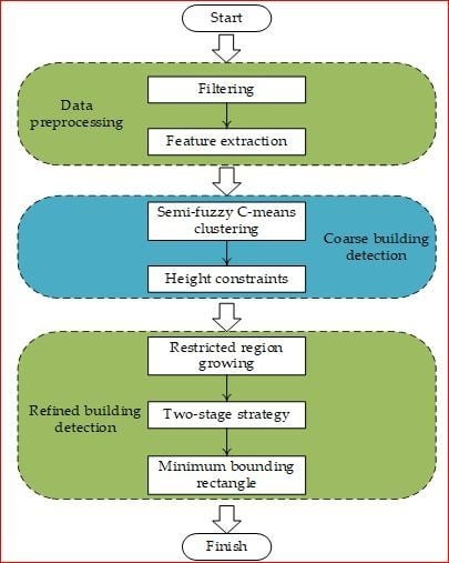
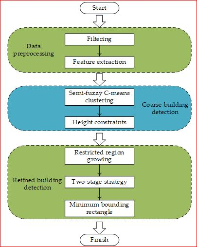
3. Methodology
3.1. Filtering
3.2. Building Detection
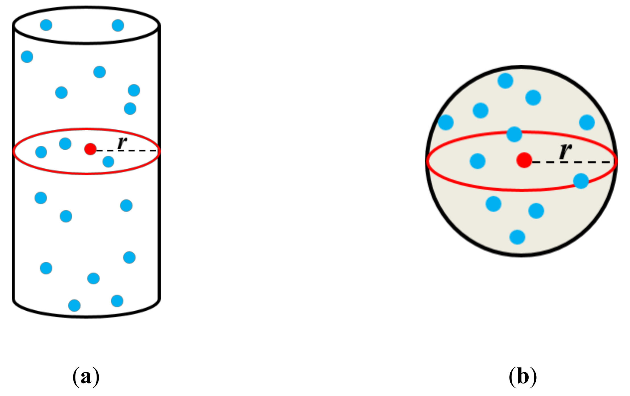
3.2.1. Feature Extraction
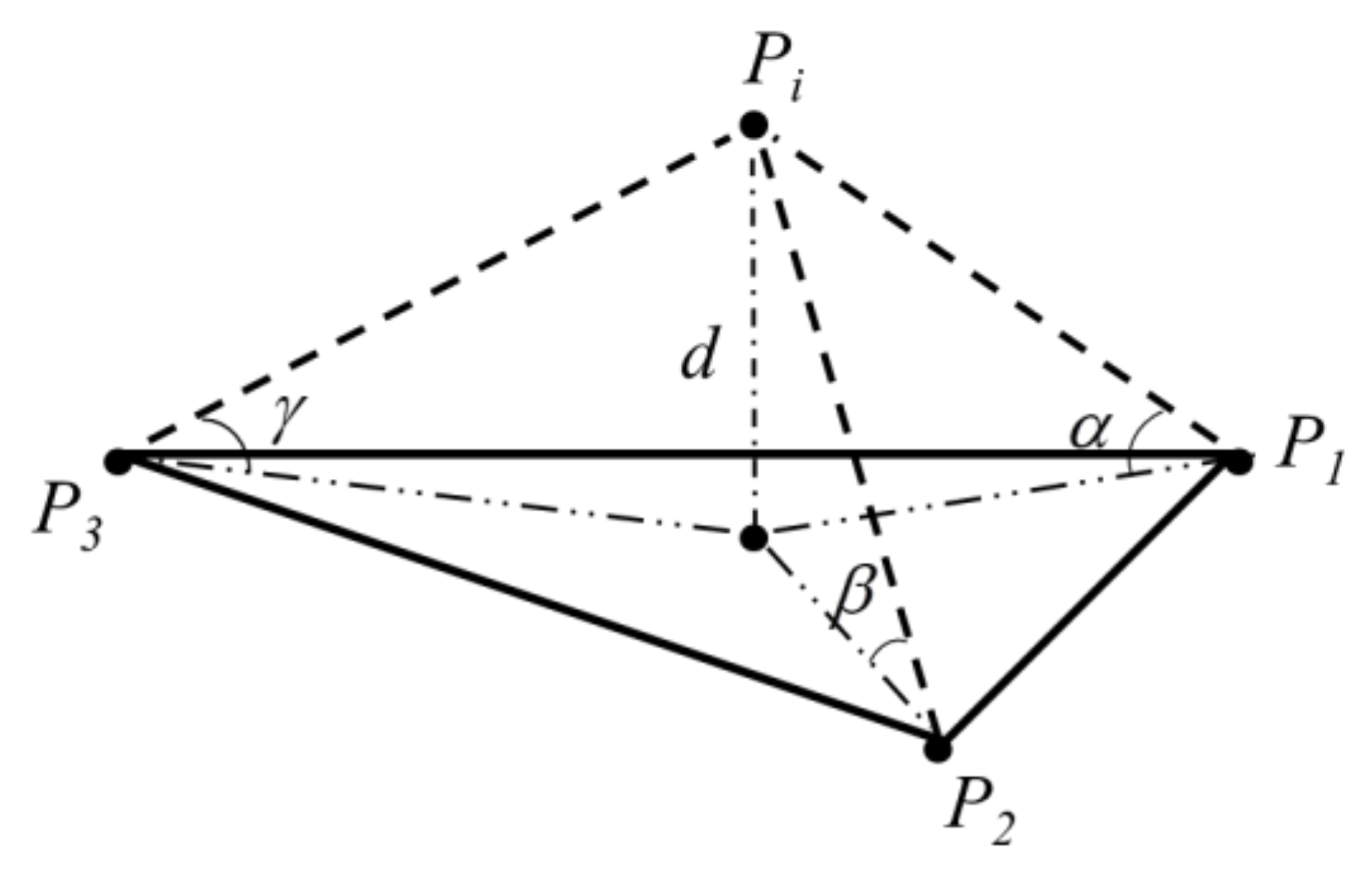
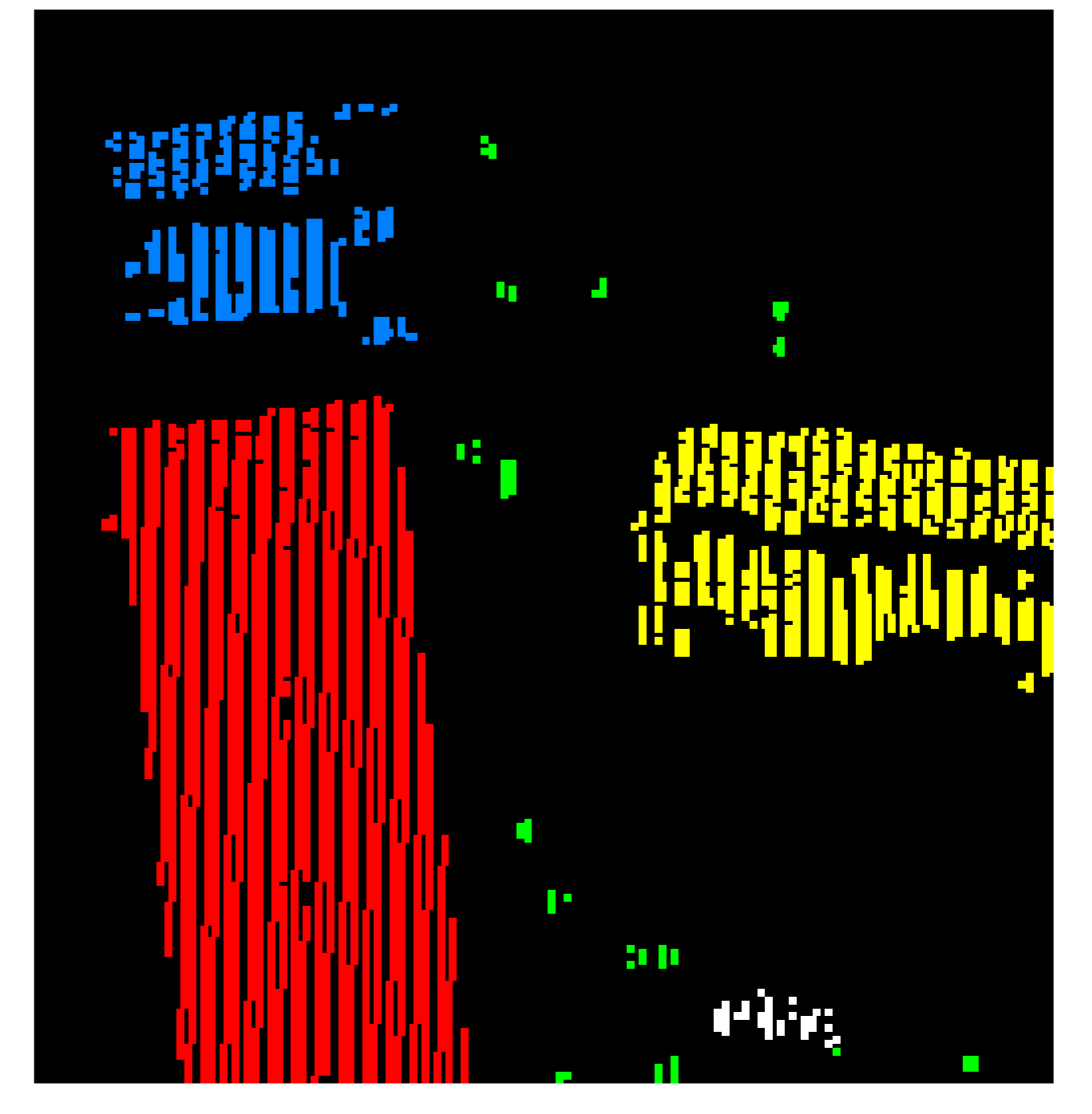
3.2.2. Coarse Building Detection Based on Semi-Suppressed FUZZY C-Means
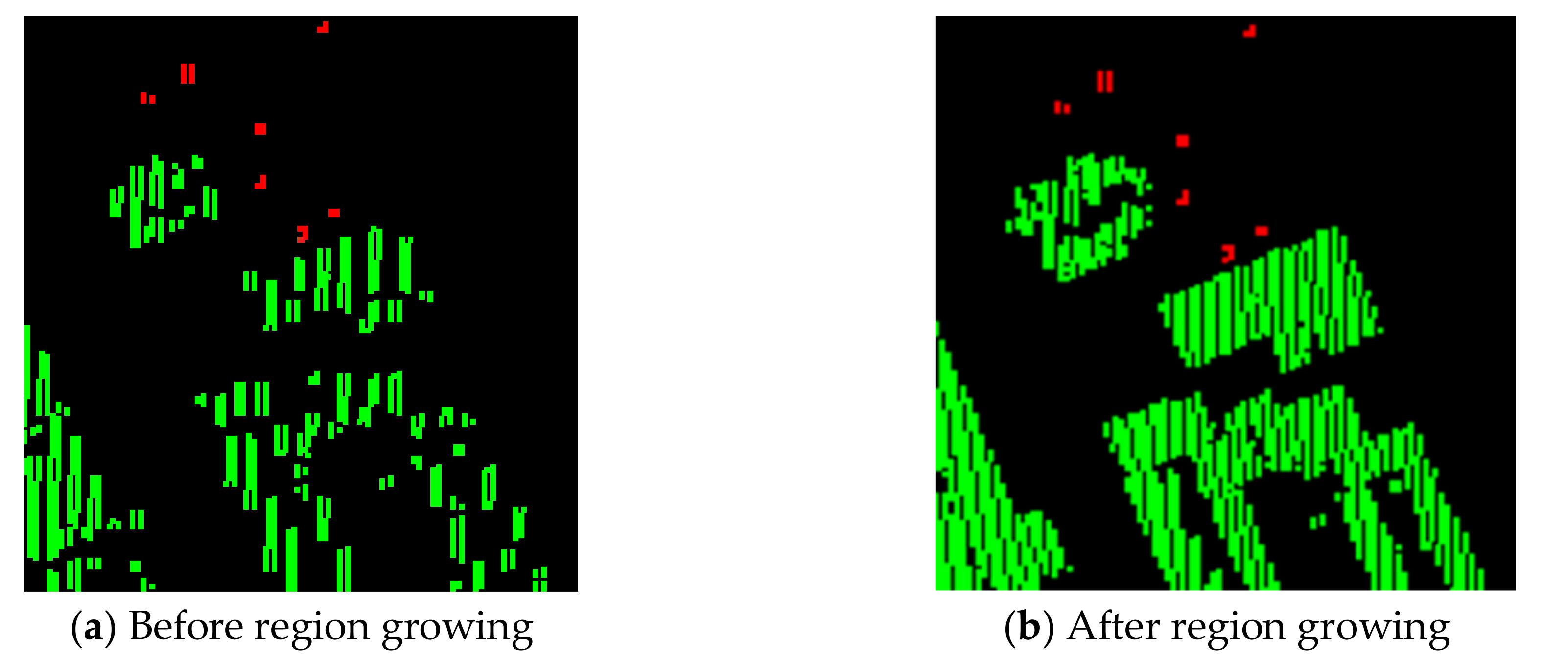
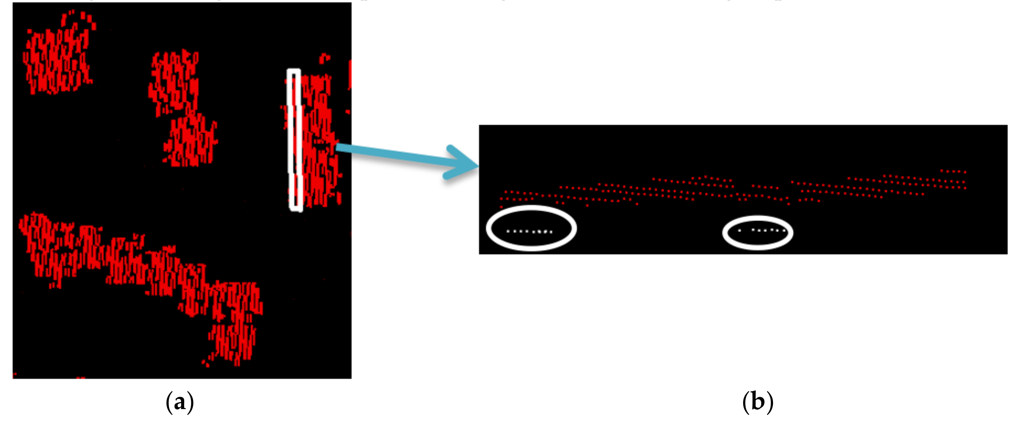
3.2.3. Refined Building Detection Based on Restricted Region Growing
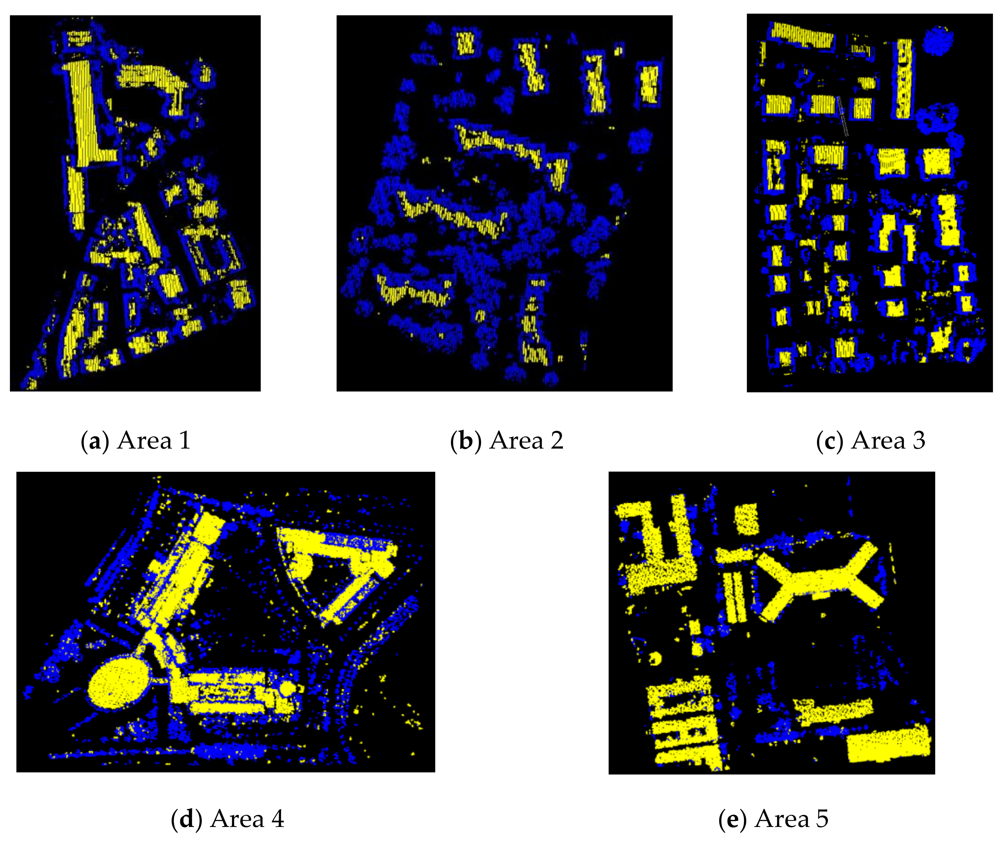
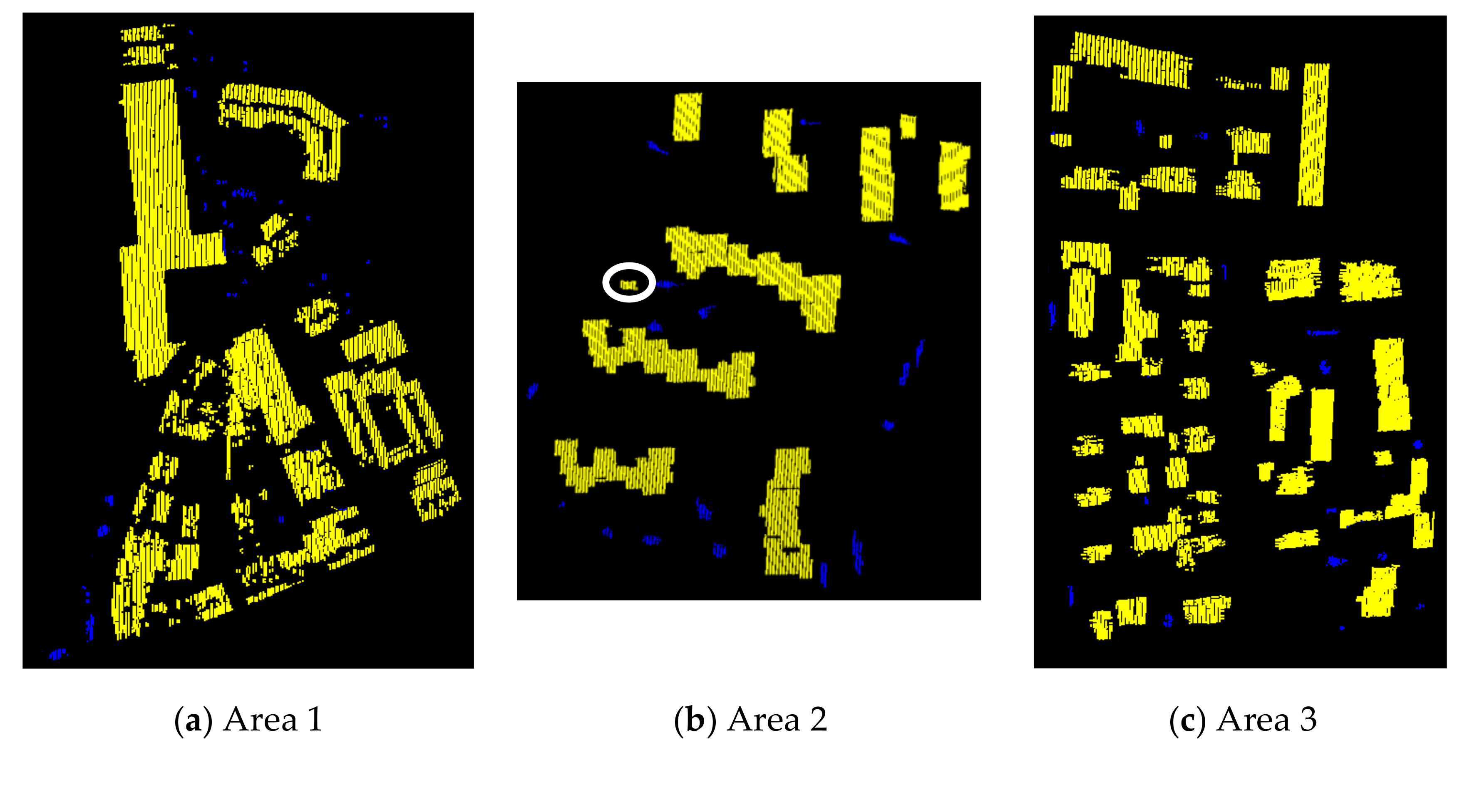
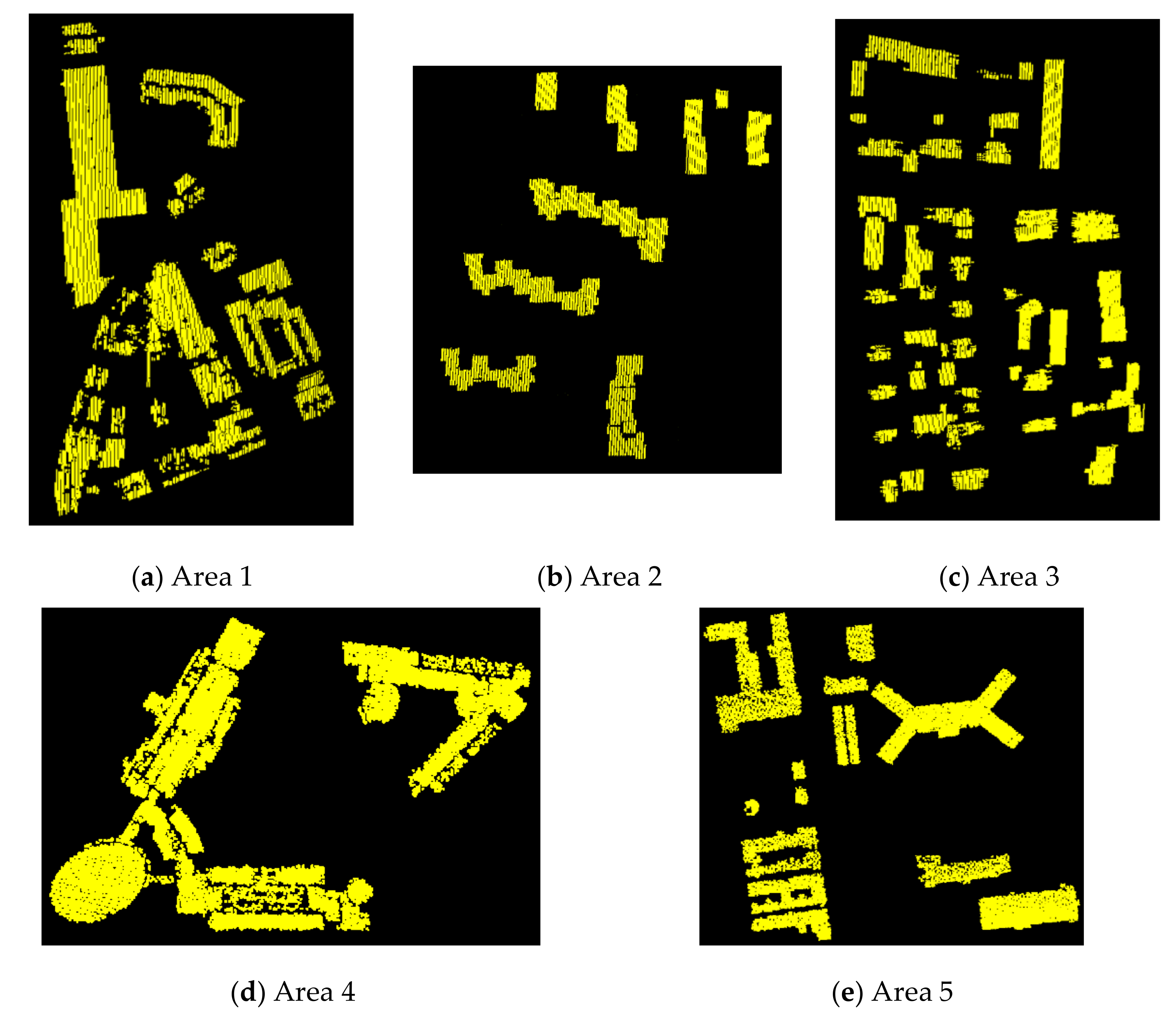
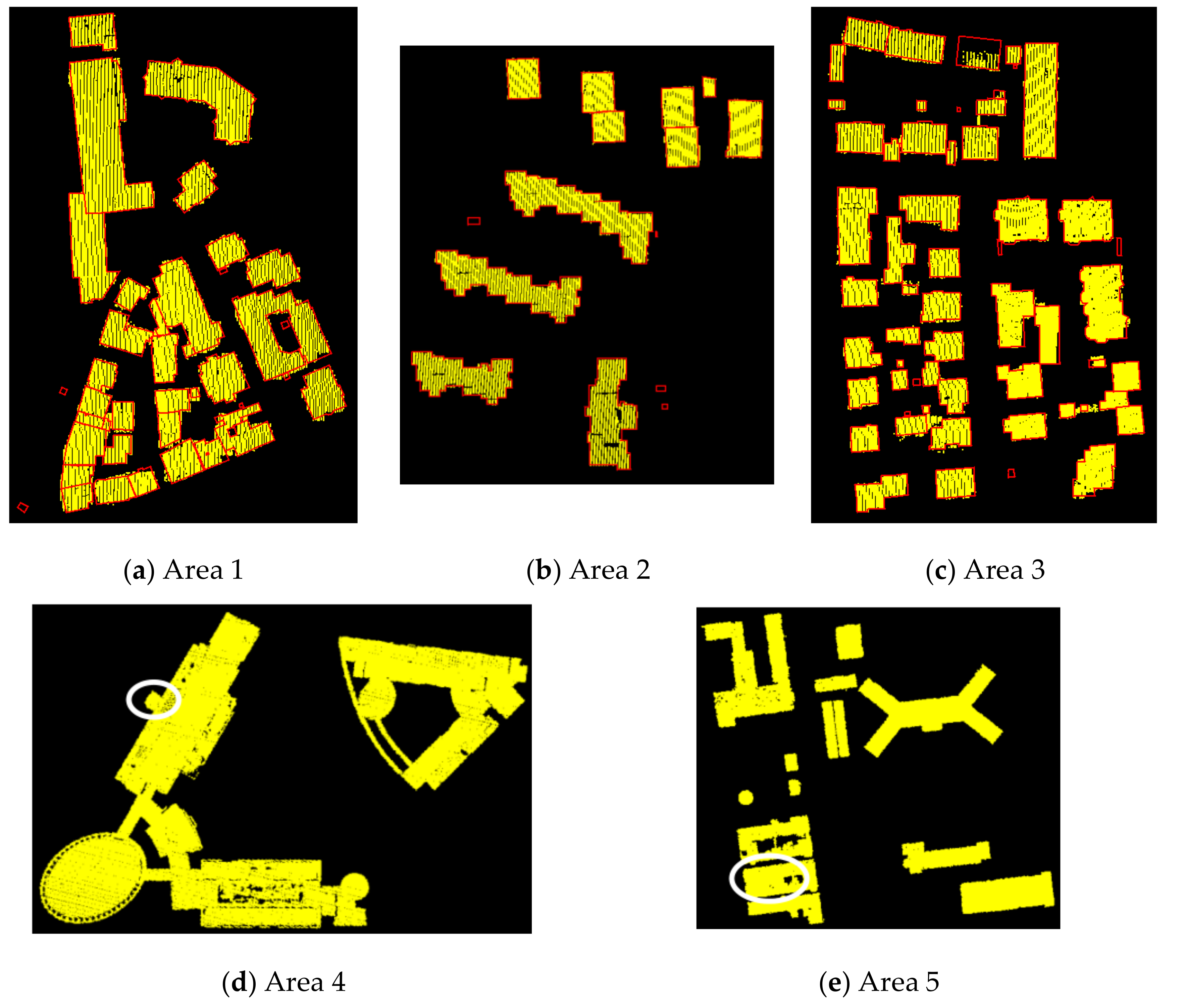
4. Results
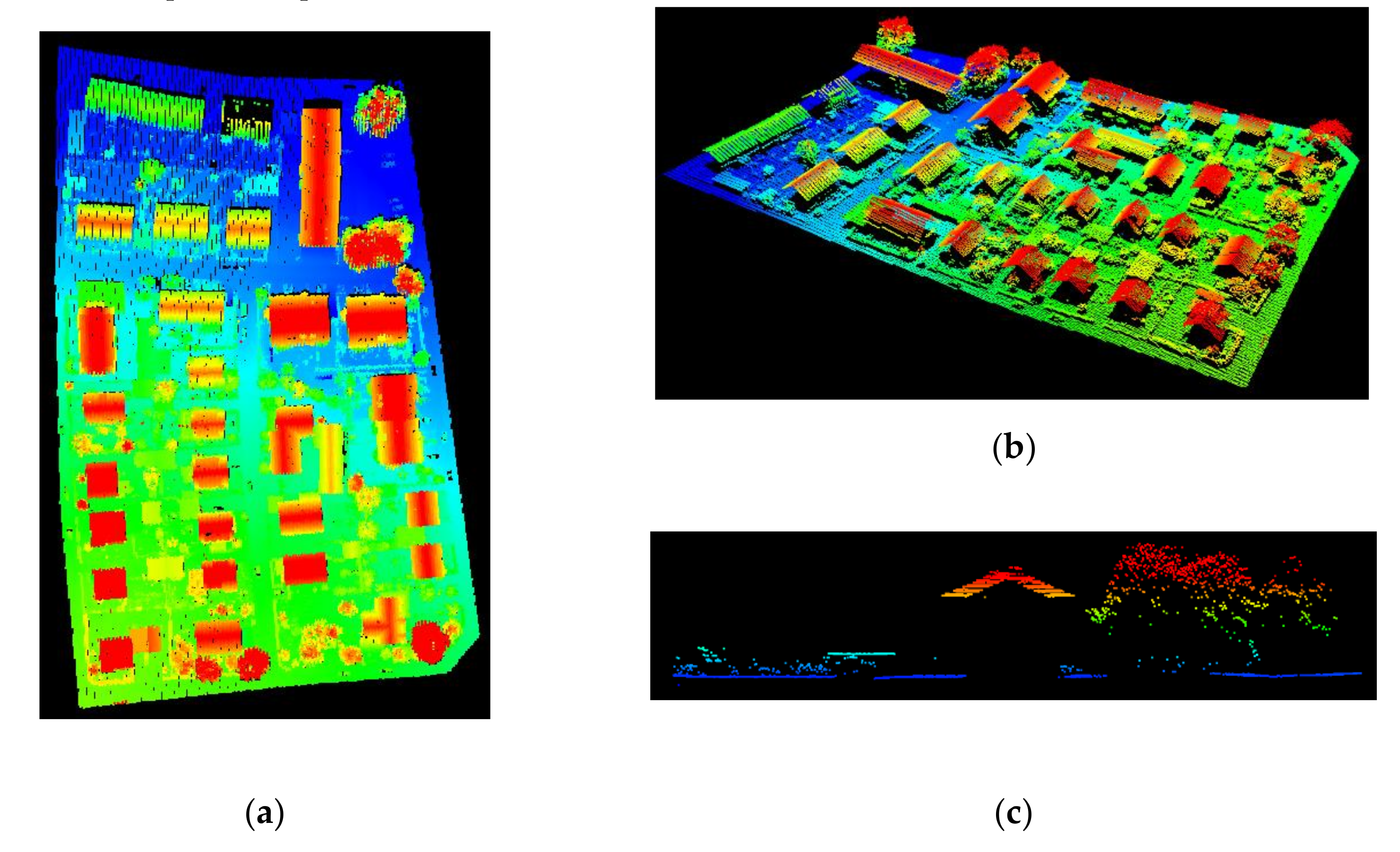
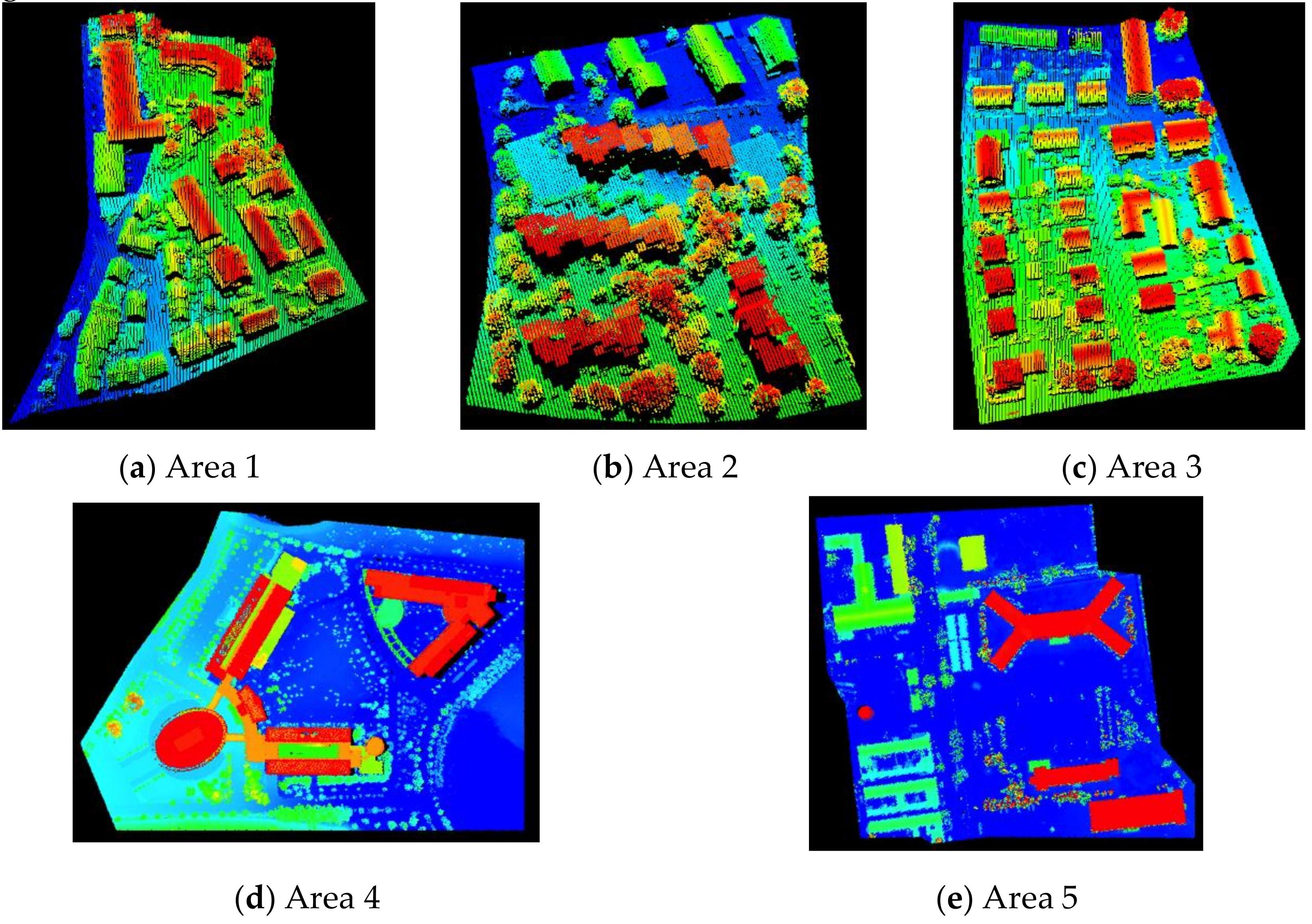
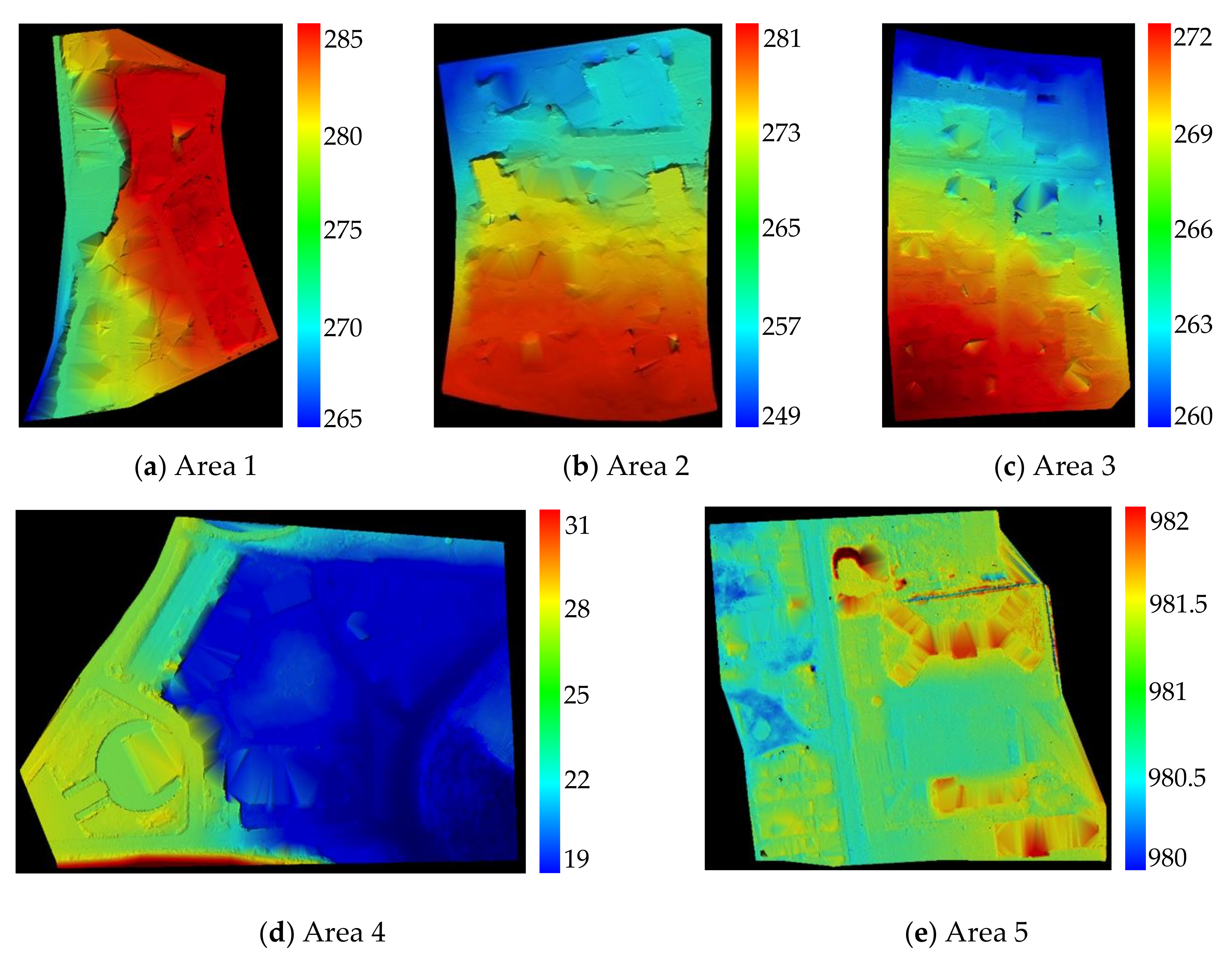
4.1. Data and Environment Desciption
4.2. Accuracy Evaluation and Disscussion
5. Conclusions
Author Contributions
Funding
Acknowledgments
Conflicts of Interest
References
- Baltsavias, E.P. Airborne laser scanning: Existing systems and firms and other resources. ISPRS J. Photogramm. Remote Sens. 1999, 54, 164–198. [Google Scholar] [CrossRef]
- Shi, X.; Ma, H.; Chen, Y.; Zhang, L.; Zhou, W. A parameter-free progressive TIN densification filtering algorithm for lidar point clouds. Int. J. Remote Sens. 2018, 4, 1–14. [Google Scholar] [CrossRef]
- Zhang, J.; Lin, X. Filtering airborne LiDAR data by embedding smoothness-constrained segmentation in progressive TIN densification. ISPRS J. Photogramm. Remote Sens. 2013, 81, 44–59. [Google Scholar] [CrossRef]
- Khoshelham, K.; Nardinocchi, C.; Frontoni, E.; Mancini, A.; Zingaretti, P. Performance evaluation of automated approaches to building detection in multi-source aerial data. ISPRS J. Photogramm. Remote Sens. 2010, 65, 123–133. [Google Scholar]
- Zhang, Y.; Liu, X.; Zhao, Z. Roof plane extraction from airborne lidar point clouds AU-Cao, Rujun. Int. J. Remote Sens. 2017, 38, 3684–3703. [Google Scholar]
- Du, S.; Zhang, Y.; Zou, Z.; Xu, S.; He, X.; Chen, S. Automatic building extraction from LiDAR data fusion of point and grid-based features. ISPRS J. Photogramm. Remote Sens. 2017, 130, 294–307. [Google Scholar] [CrossRef]
- Huang, R.; Yang, B.; Liang, F.; Dai, W.; Li, J.; Tian, M.; Xu, W. A top-down strategy for buildings extraction from complex urban scenes using airborne LiDAR point clouds. Infrared Phys. Technol. 2018, 92, 203–218. [Google Scholar] [CrossRef]
- Tomljenovic, I.; Tiede, D.; Blaschke, T. A building extraction approach for Airborne Laser Scanner data utilizing the Object Based Image Analysis paradigm. Int. J. Appl. Earth Obs. Geoinf. 2016, 52, 137–148. [Google Scholar] [CrossRef]
- Zhou, Z.; Gong, J. Automated residential building detection from airborne LiDAR data with deep neural networks. Adv. Eng. Inform. 2018, 36, 229–241. [Google Scholar] [CrossRef]
- Rottensteiner, F.; Sohn, G.; Gerke, M.; Wegner, J.D.; Breitkopf, U.; Jung, J. Results of the ISPRS benchmark on urban object detection and 3D building reconstruction. ISPRS J. Photogramm. Remote Sens. 2014, 93, 256–271. [Google Scholar] [CrossRef]
- Tomljenovic, I.; Höfle, B.; Tiede, D.; Blaschke, T. Building extraction from Airborne Laser Scanning data: An analysis of the State of the Art. Remote Sens. 2015, 7, 3826. [Google Scholar] [CrossRef]
- Wang, R.; Peethambaran, J.; Chen, D. LiDAR point clouds to 3-D urban models: A review. IEEE J. Sel. Top. Appl. Earth Obs. Remote Sens. 2018, 11, 606–627. [Google Scholar] [CrossRef]
- Sohn, G.; Dowman, I. Data fusion of high-resolution satellite imagery and LiDAR data for automatic building extraction. ISPRS J. Photogramm. Remote Sens. 2007, 62, 43–63. [Google Scholar] [CrossRef]
- Chen, L.C.; Teo, T.-A.; Shao, Y.-C.; Lai, Y.-C.; Rau, J.-Y. Fusion of LIDAR data and optical imagery for building modeling. Int. Arch. Photogramm. Remote Sens. 2004, 35, 732–737. [Google Scholar]
- Matikainen, L.; Kaartinen, H.; Hyyppä, J. Classification tree based building detection from laser scanner and aerial image data. Int. Arch. Photogramm. Remote Sens. Spat. Inf. Sci. 2007, 36, W52. [Google Scholar]
- Gilani, S.; Awrangjeb, M.; Lu, G. Fusion of lidar data and multispectral imagery for effective building detection based on graph and connected component analysis. Int. Arch. Photogramm. Remote Sens. Spat. Inf. Sci. 2015, 40, 65–72. [Google Scholar] [CrossRef]
- Vu, T.T.; Matsuoka, M.; Yamazaki, F. LiDAR signatures to update Japanese building inventory database. In Proceedings of the 25th Asian Conference on Remote Sensing, Istanbul, Turkey, 12–23 July 2004; Volume XXXV, pp. 607–610. [Google Scholar]
- Rottensteiner, F.; Trinder, J.; Clode, S.; Kubik, K.; Lovell, B. Building detection by Dempster-Shafer fusion of LIDAR data and multispectral aerial imagery. In Proceedings of the 17th International Conference on Pattern Recognition, Cambridge, UK, 26 August 2004; Volume 2, pp. 339–342. [Google Scholar]
- Peng, D.; Zhang, Y. Building change detection by combining lidar data and ortho image. Int. Arch. Photogramm. Remote Sens. Spat. Inf. Sci. 2016, 41, 669. [Google Scholar] [CrossRef]
- Schwalbe, E.; Maas, H.-G.; Seidel, F. 3D building model generation from airborne laser scanner data using 2D GIS data and orthogonal point cloud projections. In Proceedings of the ISPRS WG III/3, III/4, V/3 Workshop on Laser Scanning, Enschede, The Netherlands, 12–14 September 2005. [Google Scholar]
- Salimzadeh, N.; Hammad, A. High-level framework for GIS-based optimization of building photovoltaic potential at urban scale using BIM and LiDAR. In Proceedings of the International Conference on Sustainable Infrastructure, New York, NY, USA, 26–28 October 2017; pp. 123–134. [Google Scholar]
- Fischler, M.A.; Bolles, R.C. Random sample consensus: A paradigm for model fitting with applications to image analysis and automated cartography. Commun. ACM 1981, 24, 381–395. [Google Scholar] [CrossRef]
- Li, L.; Yang, F.; Zhu, H.; Li, D.; Li, Y.; Tang, L. An improved RANSAC for 3D point cloud plane segmentation based on normal distribution transformation cells. Remote Sens. 2017, 9, 433. [Google Scholar] [CrossRef]
- Schnabel, R.; Wahl, R.; Klein, R. Efficient RANSAC for point-cloud shape detection. Comput. Graph. Forum 2007, 26, 214–226. [Google Scholar] [CrossRef]
- Xu, B.; Jiang, W.; Shan, J.; Zhang, J.; Li, L. Investigation on the weighted RANSAC approaches for building roof plane segmentation from LiDAR point clouds. Remote Sens. 2016, 8, 5. [Google Scholar] [CrossRef]
- Hofman, P.; Potůčková, M. Comprehensive approach for building outline extraction from LiDAR data with accent to a sparse laser scanning point cloud. Geoinformatics FCE CTU 2017, 16, 91–102. [Google Scholar] [CrossRef]
- Leavers, V.F. Which Hough transform? CVGIP Image Underst. 1993, 58, 250–264. [Google Scholar] [CrossRef]
- Vosselman, G.; Gorte, B.G.; Sithole, G.; Rabbani, T. Recognising structure in laser scanner point clouds. Int. Arch. Photogramm. Remote Sens. Spat. Inf. Sci. 2004, 46, 33–38. [Google Scholar]
- Khoshelham, K. Extending generalized hough transform to detect 3d objects in laser range data. In Proceedings of the ISPRS Workshop on Laser Scanning and SilviLaser 2007, Espoo, Finland, 12–14 September 2007. [Google Scholar]
- Vo, A.-V.; Truong-Hong, L.; Laefer, D.F.; Bertolotto, M. Octree-based region growing for point cloud segmentation. ISPRS J. Photogramm. Remote Sens. 2015, 104, 88–100. [Google Scholar] [CrossRef]
- Xu, Y.; Yao, W.; Hoegner, L.; Stilla, U. Segmentation of building roofs from airborne LiDAR point clouds using robust voxel-based region growing AU-Xu, Yusheng. Remote Sens. Lett. 2017, 8, 1062–1071. [Google Scholar] [CrossRef]
- Miliaresis, G.; Kokkas, N. Segmentation and object-based classification for the extraction of the building class from LIDAR DEMs. Comput. Geosci. 2007, 33, 1076–1087. [Google Scholar] [CrossRef]
- Song, J.; Wu, J.; Jiang, Y. Extraction and reconstruction of curved surface buildings by contour clustering using airborne LiDAR data. Optik 2015, 126, 513–521. [Google Scholar] [CrossRef]
- Wu, T.; Hu, X.; Ye, L. Fast and accurate plane segmentation of airborne LiDAR point cloud using cross-line elements. Remote Sens. 2016, 8, 383. [Google Scholar] [CrossRef]
- Guo, L.; Chehata, N.; Mallet, C.; Boukir, S. Relevance of airborne lidar and multispectral image data for urban scene classification using Random Forests. ISPRS J. Photogramm. Remote Sens. 2011, 66, 56–66. [Google Scholar] [CrossRef]
- Guo, B.; Huang, X.; Zhang, F.; Sohn, G. Classification of airborne laser scanning data using JointBoost. ISPRS J. Photogramm. Remote Sens. 2015, 100, 71–83. [Google Scholar] [CrossRef]
- Ma, H.; Cai, Z.; Zhang, L. Comparison of the filtering models for airborne LiDAR data by three classifiers with exploration on model transfer. J. Appl. Remote Sens. 2018, 12, 18. [Google Scholar] [CrossRef]
- Cai, Z.; Ma, H.; Zhang, L. Model transfer-based filtering for airborne LiDAR data with emphasis on active learning optimization. Remote Sens. Lett. 2018, 9, 111–120. [Google Scholar] [CrossRef]
- Axelsson, P. DEM generation from laser scanner data using adaptive TIN models. Int. Arch. Photogramm. Remote Sens. 2000, 33, 111–118. [Google Scholar]
- Kim, H.; Sohn, G. 3D classification of power-line scene from airborne laser scanning data using random forests. Int. Arch. Photogramm. Remote Sens 2010, 38, 126–132. [Google Scholar]
- Rutzinger, M.; Höfle, B.; Hollaus, M.; Pfeifer, N. Object-based point cloud analysis of full-waveform airborne laser scanning data for urban vegetation classification. Sensors 2008, 8, 4505–4528. [Google Scholar] [CrossRef]
- Fan, J.-L.; Zhen, W.-Z.; Xie, W.-X. Suppressed fuzzy c-means clustering algorithm. Pattern Recognit. Lett. 2003, 24, 1607–1612. [Google Scholar] [CrossRef]
- Bezdek, J.C. Pattern recognition with fuzzy objective function algorithms. Adv. Appl. Pattern Recognit. 1981, 22, 203–239. [Google Scholar]
- Zhao, F.; Fan, J.; Liu, H. Optimal-selection-based suppressed fuzzy c-means clustering algorithm with self-tuning non local spatial information for image segmentation. Expert Syst. Appl. 2014, 41, 4083–4093. [Google Scholar] [CrossRef]
- Cramer, M. The DGPF-test on digital airborne camera evaluation—Overview and test design. Photogramm. Fernerkund. Geoinf. 2010, 2010, 73–82. [Google Scholar] [CrossRef]
- Awrangjeb, M.; Fraser, C.S. Automatic segmentation of raw LIDAR data for extraction of building roofs. Remote Sens. 2014, 6, 3716. [Google Scholar] [CrossRef]


| Neighborhood | Cylinder-Based | Sphere-Based | |
|---|---|---|---|
| Features | |||
| Height-related | Height variance | ||
| Height range | |||
| Eigenvalue-related | Planarity | Sphericity | |
| Omnivariance | Change of curvature | ||
| Plane-related | Surface roughness | ||
| Distance to plane | |||
| Density-related | Point density | ||
| Point density ratio | |||
| Others | Point count ratio | ||
| Data | Precision | RANSAC | Awrangjeb | Du | Huang | Ours |
|---|---|---|---|---|---|---|
| Area 1 | Comp | 870.0 | 83.8 | 93.6 | 91.8 | 95.6 |
| Corr | 95.2 | 96.9 | 94.5 | 98.6 | 94.2 | |
| Q | 83.3 | 81.6 | 88.8 | 90.6 | 90.2 | |
| Area 2 | Comp | 91.0 | 85.7 | 94.6 | 87.3 | 89.5 |
| Corr | 99.2 | 84.6 | 95.4 | 99.0 | 97.3 | |
| Q | 90.4 | 74.2 | 90.5 | 86.5 | 87.3 | |
| Area 3 | Comp | 94.7 | 78.6 | 93.9 | 90.2 | 95.1 |
| Corr | 98.4 | 97.8 | 94.7 | 98.1 | 95.8 | |
| Q | 93.3 | 77.2 | 89.2 | 88.7 | 91.3 | |
| Average | Comp | 90.9 | 82.7 | 94.0 | 89.8 | 93.4 |
| Corr | 97.6 | 93.1 | 94.9 | 98.6 | 95.8 | |
| Q | 89.0 | 77.7 | 89.5 | 88.6 | 89.6 | |
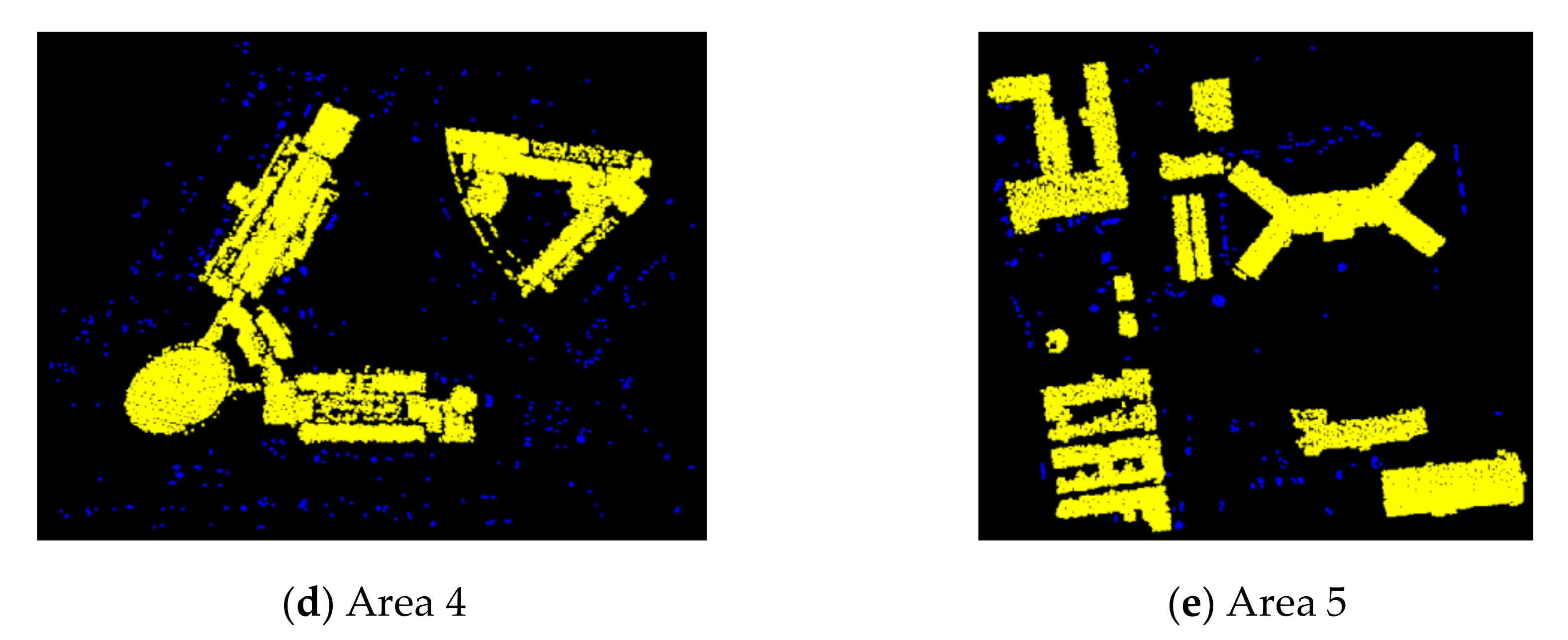
| Area 4 | Comp | / | / | / | / | 93.2 |
| Corr | / | / | / | / | 91.0 | |
| Q | / | / | / | / | 85.2 | |
| Area 5 | Comp | / | / | / | / | 96.9 |
| Corr | / | / | / | / | 91.2 | |
| Q | / | / | / | / | 88.6 |
© 2019 by the authors. Licensee MDPI, Basel, Switzerland. This article is an open access article distributed under the terms and conditions of the Creative Commons Attribution (CC BY) license (http://creativecommons.org/licenses/by/4.0/).
Share and Cite
Cai, Z.; Ma, H.; Zhang, L. A Building Detection Method Based on Semi-Suppressed Fuzzy C-Means and Restricted Region Growing Using Airborne LiDAR. Remote Sens. 2019, 11, 848. https://doi.org/10.3390/rs11070848
Cai Z, Ma H, Zhang L. A Building Detection Method Based on Semi-Suppressed Fuzzy C-Means and Restricted Region Growing Using Airborne LiDAR. Remote Sensing. 2019; 11(7):848. https://doi.org/10.3390/rs11070848
Chicago/Turabian StyleCai, Zhan, Hongchao Ma, and Liang Zhang. 2019. "A Building Detection Method Based on Semi-Suppressed Fuzzy C-Means and Restricted Region Growing Using Airborne LiDAR" Remote Sensing 11, no. 7: 848. https://doi.org/10.3390/rs11070848
APA StyleCai, Z., Ma, H., & Zhang, L. (2019). A Building Detection Method Based on Semi-Suppressed Fuzzy C-Means and Restricted Region Growing Using Airborne LiDAR. Remote Sensing, 11(7), 848. https://doi.org/10.3390/rs11070848