The Effect of Snow Depth on Spring Wildfires on the Hulunbuir from 2001–2018 Based on MODIS

Abstract
:1. Introduction
2. Materials and Methods
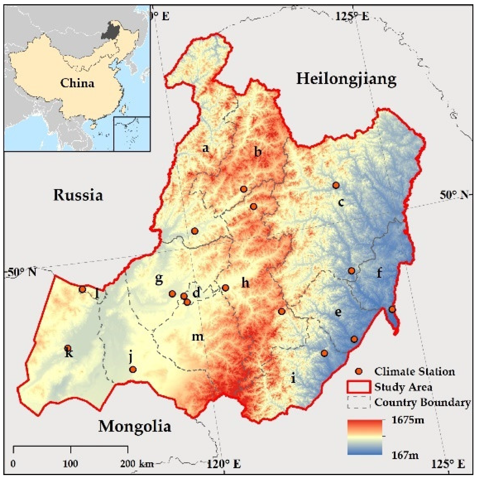
2.1. Study Area
2.2. Data
2.2.1. Spring Wildfire Dataset
2.2.2. Snow Depth Data
2.2.3. LSWI Data
2.2.4. LST Data
2.2.5. Land Cover Data
2.3. Methods
2.3.1. Density of SWF Points
2.3.2. Trend Analysis
2.3.3. Correlation Analysis between SWFs and Influencing Factors
2.3.4. Hurst Exponent and R/S Analysis
3. Results
3.1. Relationships between SWFs and Snow Depth
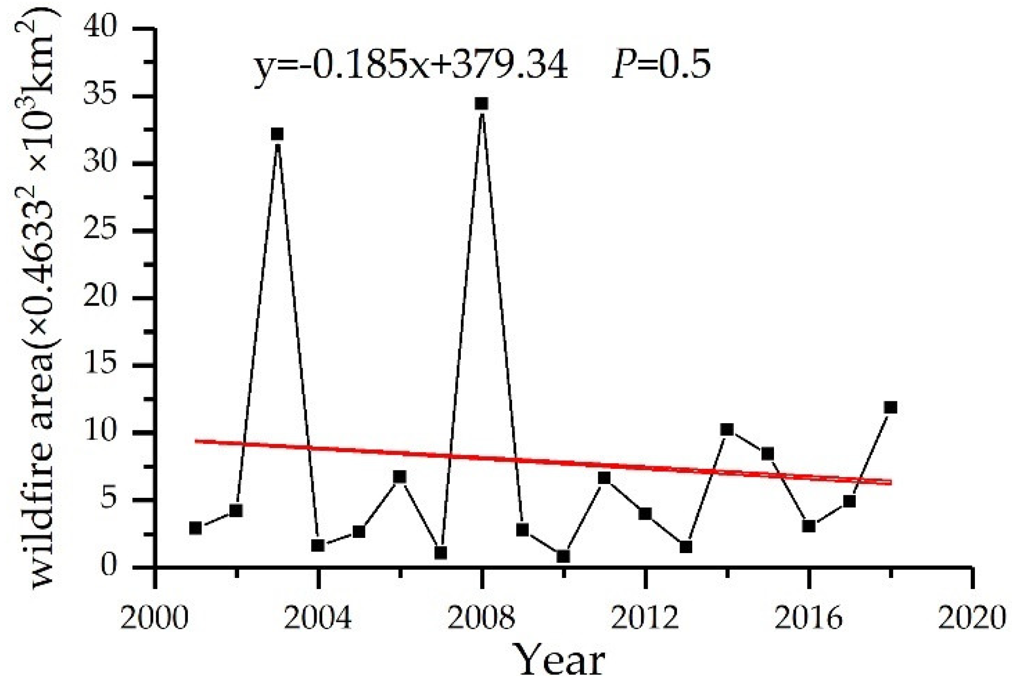
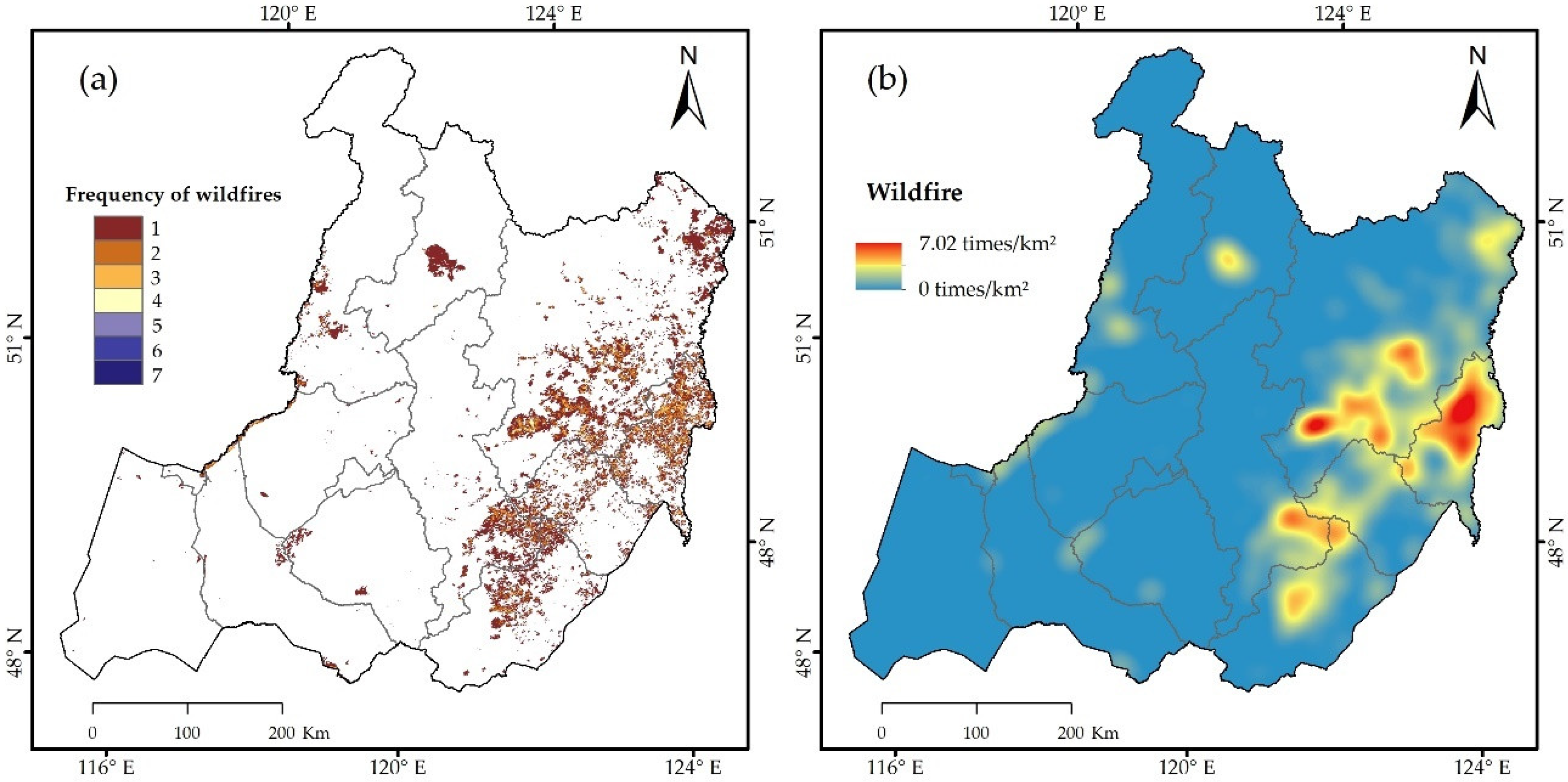
3.1.1. Change and Distribution of SWFs
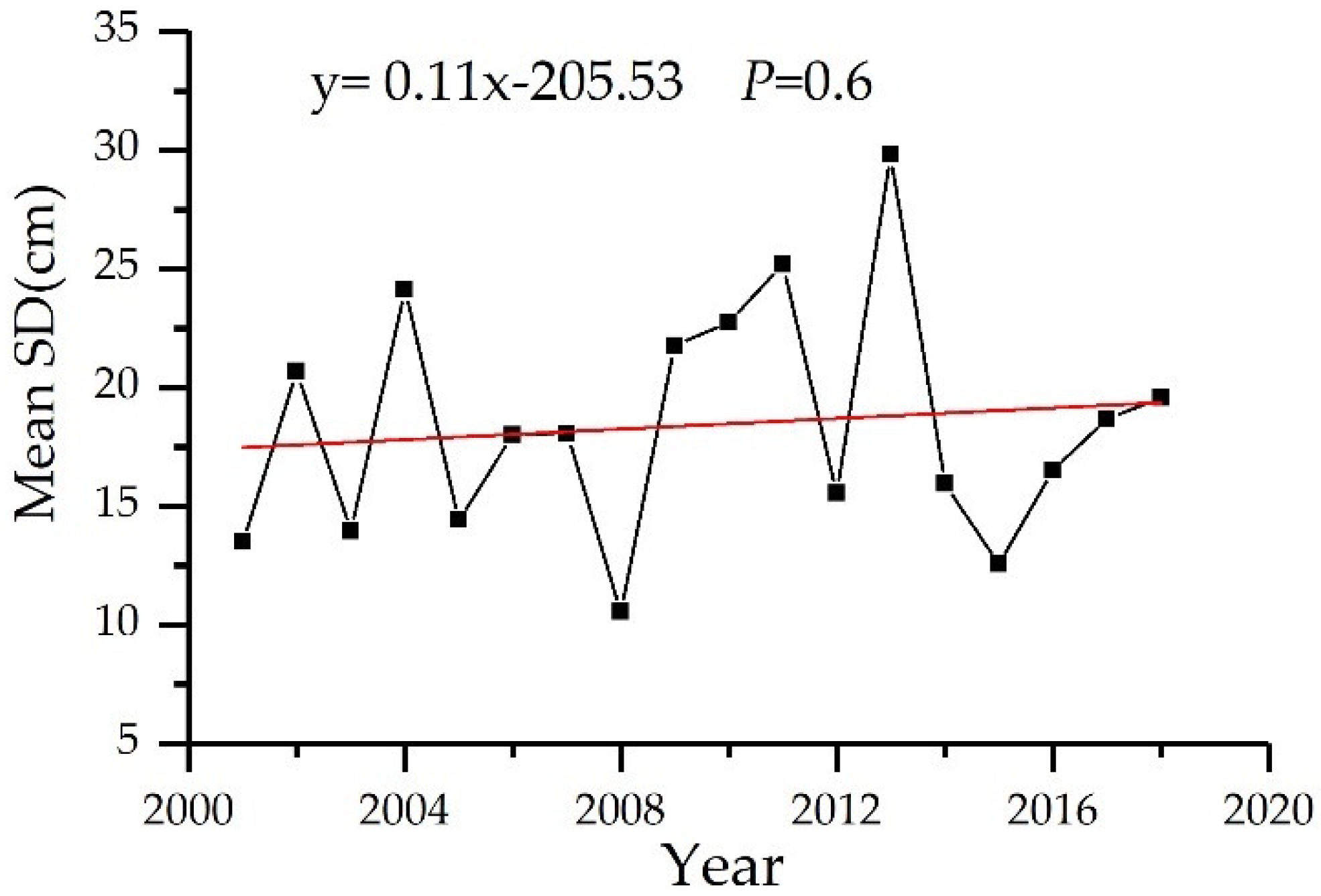
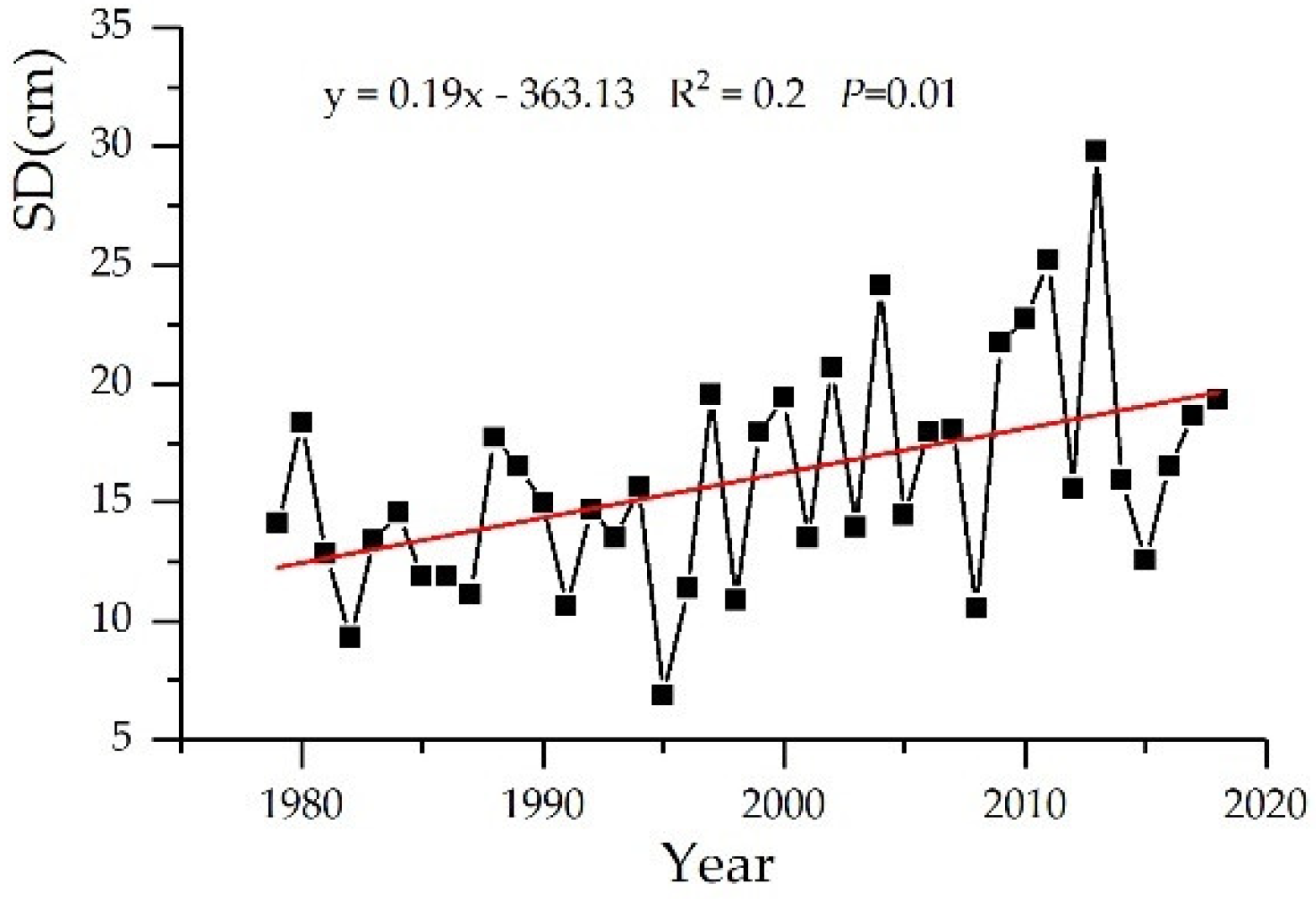
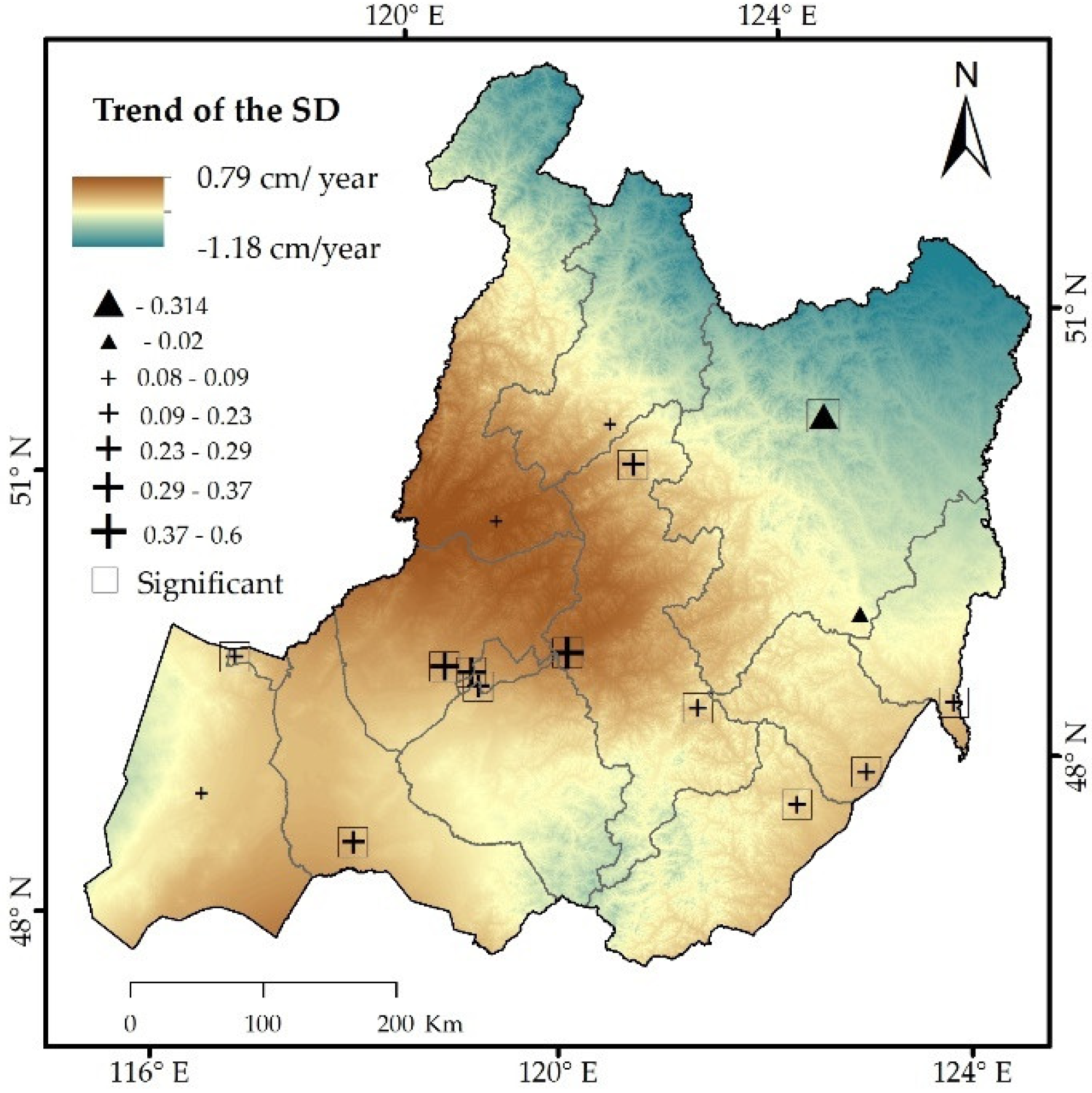
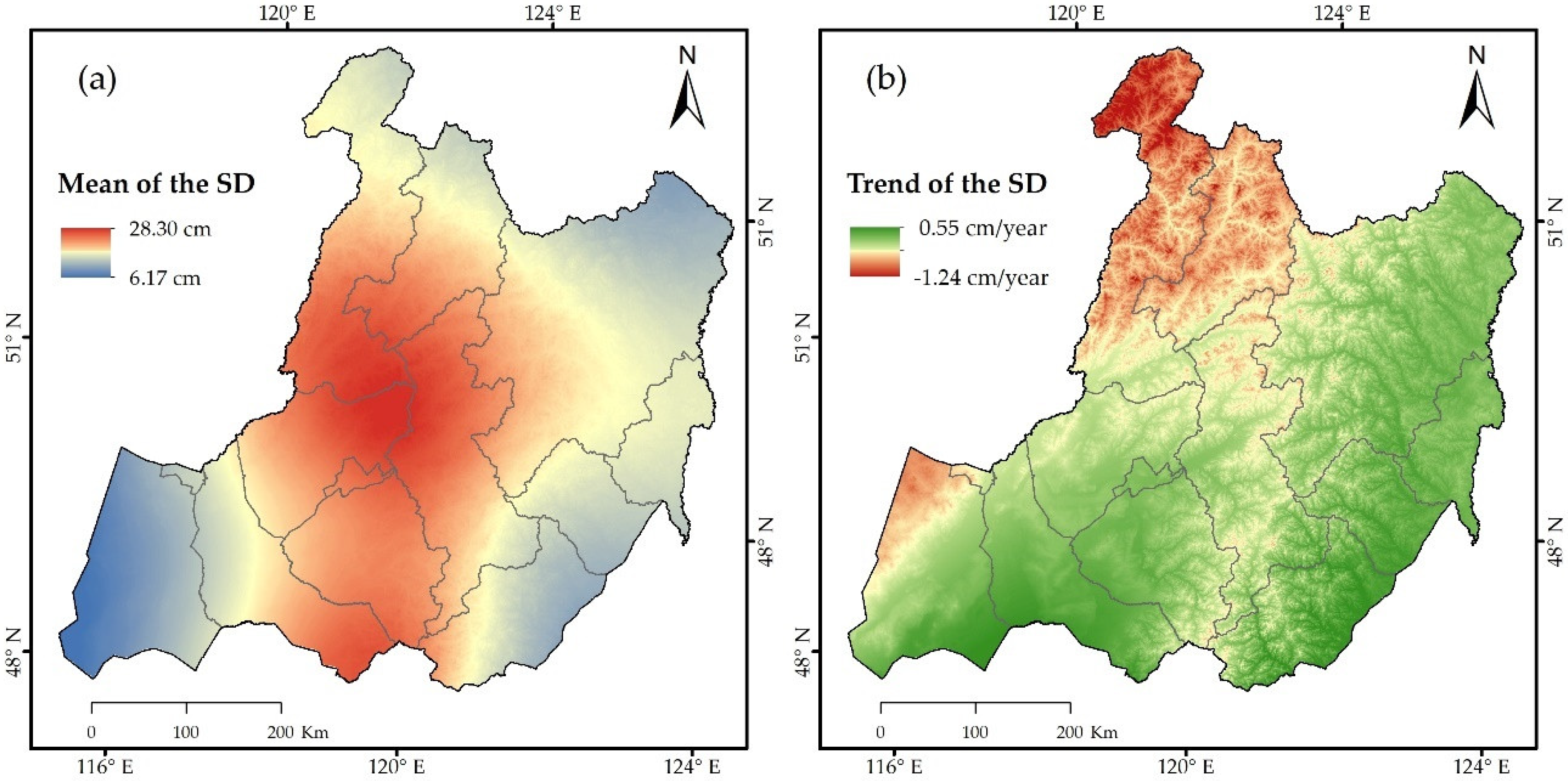
3.1.2. Temporal and Spatial Variation in Snow Depth during the Period of 2001–2018
3.1.3. Correlation between SWFs and Snow Depth
3.2. The Mechanistic Effect of Snow on Wildfires
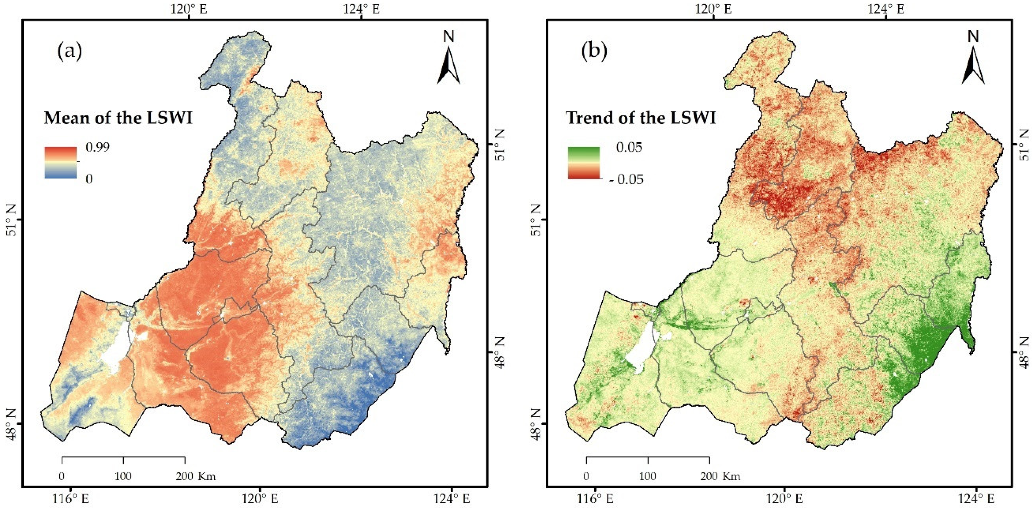
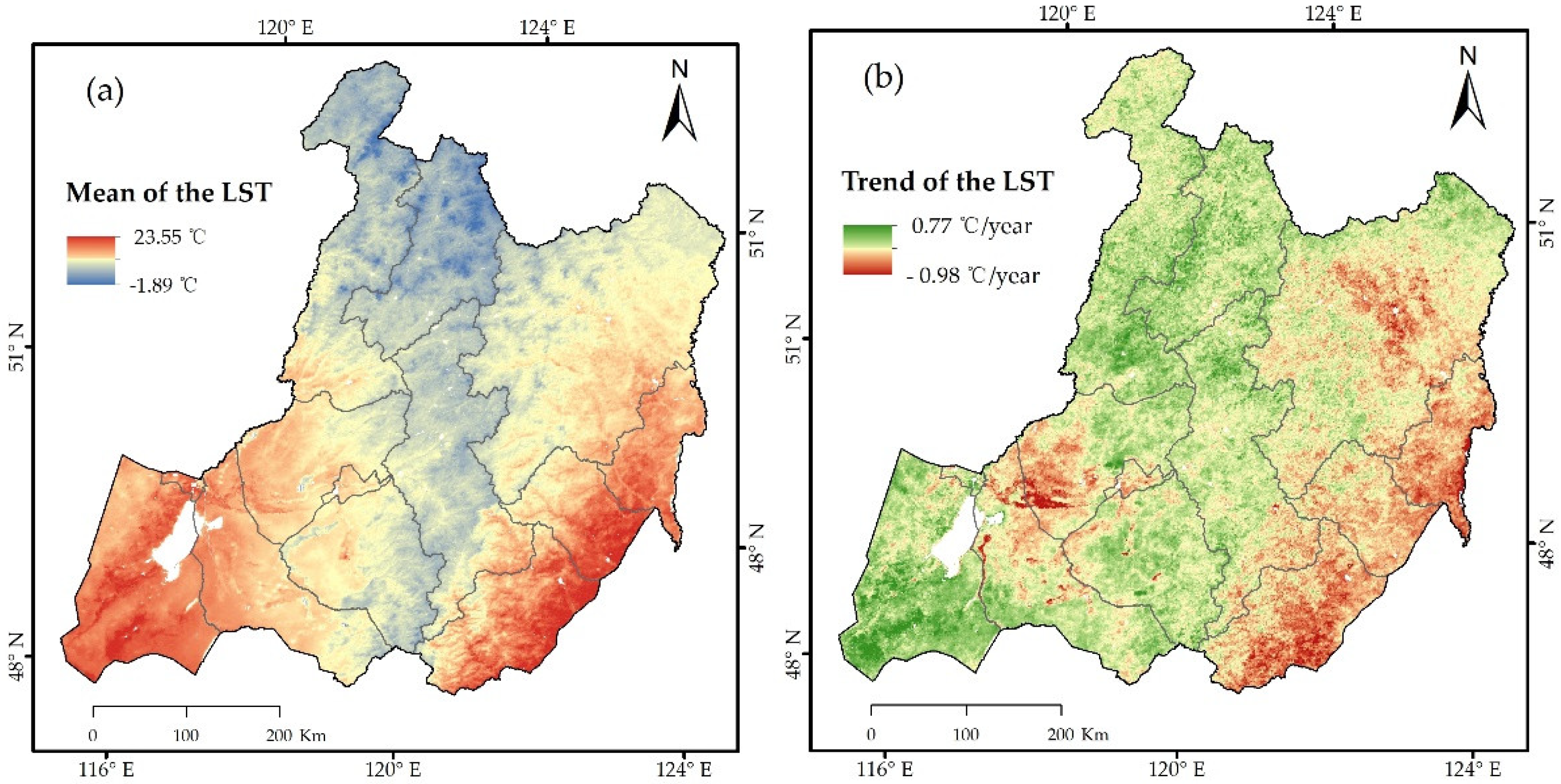
3.2.1. Spatial Distribution and Trends of the LSWI and LST in Spring
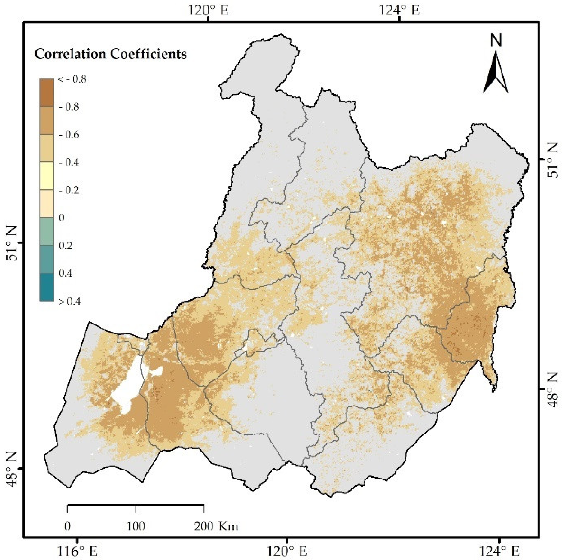
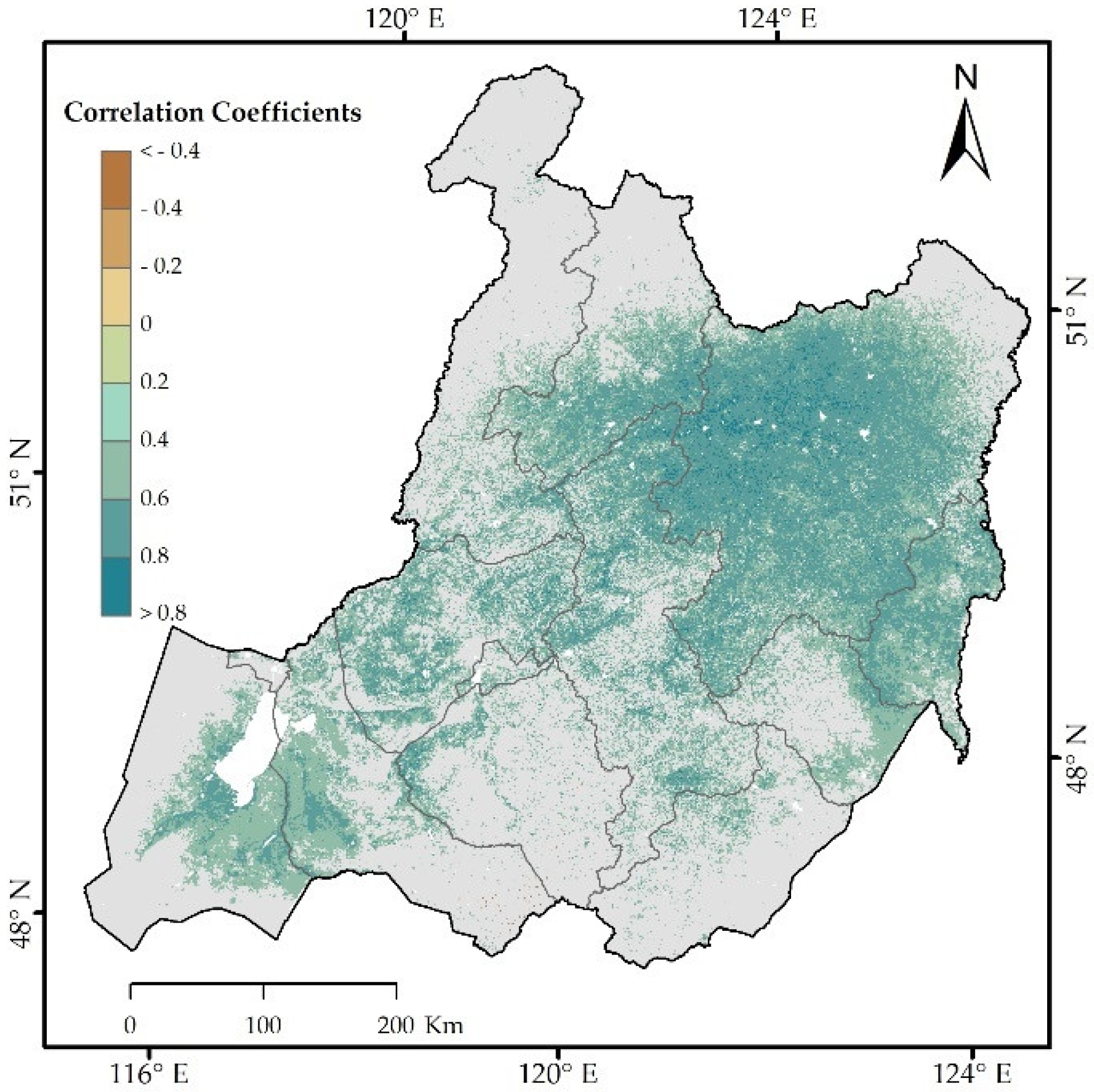
3.2.2. Correlation between Snow Depth and LSWI
3.2.3. Correlation between Snow Depth and LST
3.3. Future Prediction of Snow Depth in the Hulunbuir Region
3.3.1. Future Snow Depth Based on the Hurst Exponent
3.3.2. Validation of Future Predictions Based on the Hurst Exponent
4. Discussion
4.1. Variations in SWFs and Snow Depth
4.2. Relationships between SWFs and Snow Depth
4.3. Future Prediction of Snow Depth in the Hulunbuir Region
4.4. Uncertainty
5. Conclusions
Supplementary Materials
Author Contributions
Funding
Conflicts of Interest
References
- Hicke, J.A.; Johnson, M.C.; Hayes, J.L.; Preisler, H.K. Effects of bark beetle-caused tree mortality on wildfire. For. Ecol. Manag. 2012, 271, 81–90. [Google Scholar] [CrossRef]
- Zhu, C.; Kobayashi, H.; Kanaya, Y.; Saito, M. Size-dependent validation of MODIS MCD64A1 burned area over six vegetation types in boreal Eurasia: Large underestimation in croplands. Sci. Rep. 2017, 7. [Google Scholar] [CrossRef] [PubMed]
- Oom, D.; Pereira, J.M.C. Exploratory spatial data analysis of global MODIS active fire data. Int. J. Appl. Earth Obs. Geoinf. 2013, 21, 326–340. [Google Scholar] [CrossRef]
- Chuvieco, E.; Aguado, I.; Yebra, M.; Nieto, H.; Salas, J.; Martín, M.P.; Vilar, L.; Martínez, J.; Martín, S.; Ibarra, P. Development of a framework for fire risk assessment using remote sensing and geographic information system technologies. Ecol. Model. 2010, 221, 46–58. [Google Scholar] [CrossRef]
- Hao, W.M.; Liu, M.H. Spatial and temporal distribution of tropical biomass burning. Glob. Biogeochem. Cycles 1994, 8, 495–503. [Google Scholar] [CrossRef]
- Giglio, L.; Randerson, J.T.; van der Werf, G.R. Analysis of daily, monthly, and annual burned area using the fourth-generation global fire emissions database (GFED4): Analysis of Burned Area. J. Geophys. Res. Biogeosci. 2013, 118, 317–328. [Google Scholar] [CrossRef]
- Chen, D.; Pereira, J.M.C.; Masiero, A.; Pirotti, F. Mapping fire regimes in China using MODIS active fire and burned area data. Appl. Geogr. 2017, 85, 14–26. [Google Scholar] [CrossRef]
- Zhang, Z.; Zhang, H.; Li, D.; Xu, J.; Zhou, D. Spatial distribution pattern of human-caused fires in Hulunbeir grassland. Acta Ecol. Sin. 2013, 33, 2023–2031. [Google Scholar] [CrossRef]
- Fu, Z.Q.; Yang, Y.X.; Dai, E.F. Research on fire dynamics and fire risk climate divisions in Innermongolia. J. China Agric. Resour. Reg. Plan. 2001, 22, 18–22. [Google Scholar]
- Fu, Z.; Wang, Y.; Wang, C. Research on the spring fire-risk forecasting model in dry grasslands in inner mongolia. Q. J. Appl. Meteorol. 2001, 12, 202–209. [Google Scholar]
- Liu, M.; Zhao, J.; Guo, X.; Zhang, Z.; Tan, G.; Yang, J. Study on Climate and Grassland Fire in HulunBuir, Inner Mongolia Autonomous Region, China. Sensors 2017, 17, 616. [Google Scholar] [CrossRef] [PubMed]
- Zhang, Z.; Feng, Z.; Zhang, H.; Zhao, J.; Yu, S.; Du, W. Spatial distribution of grassland fires at the regional scale based on the MODIS active fire products. Int. J. Wildland Fire 2017, 26. [Google Scholar] [CrossRef]
- Hantson, S.; Padilla, M.; Corti, D.; Chuvieco, E. Strengths and weaknesses of MODIS hotspots to characterize global fire occurrence. Remote Sens. Environ. 2013, 131, 152–159. [Google Scholar] [CrossRef]
- Dubinin, M.; Potapov, P.; Lushchekina, A.; Radeloff, V.C. Reconstructing long time series of burned areas in arid grasslands of southern Russia by satellite remote sensing. Remote Sens. Environ. 2010, 114, 1638–1648. [Google Scholar] [CrossRef]
- Jolly, W.M.; Cochrane, M.A.; Freeborn, P.H.; Holden, Z.A.; Brown, T.J.; Williamson, G.J.; Bowman, D.M.J.S. Climate-induced variations in global wildfire danger from 1979 to 2013. Nat. Commun. 2015, 6. [Google Scholar] [CrossRef] [PubMed]
- Bedia, J.; Herrera, S.; Gutiérrez, J.M.; Benali, A.; Brands, S.; Mota, B.; Moreno, J.M. Global patterns in the sensitivity of burned area to fire-weather: Implications for climate change. Agric. For. Meteorol. 2015, 214–215, 369–379. [Google Scholar] [CrossRef]
- Fuller, D.O.; Fulk, M. Burned area in Kalimantan, Indonesia mapped with NOAA-AVHRR and Landsat TM imagery. Int. J. Remote Sens. 2001, 22, 691–697. [Google Scholar] [CrossRef]
- Nielsen, T.T.; Mbow, C.; Kane, R. A statistical methodology for burned area estimation using multitemporal AVHRR data. Int. J. Remote Sens. 2002, 23, 1181–1196. [Google Scholar] [CrossRef]
- Arino, O.; Casadio, S.; Serpe, D. Global night-time fire season timing and fire count trends using the ATSR instrument series. Remote Sens. Environ. 2012, 116, 226–238. [Google Scholar] [CrossRef]
- Giglio, L.; Kendall, J.D.; Mack, R. A multi-year active fire dataset for the tropics derived from the TRMM VIRS. Int. J. Remote Sens. 2003, 24, 4505–4525. [Google Scholar] [CrossRef]
- Prins, E.M.; Feltz, J.M.; Menzel, W.P.; Ward, D.E. An overview of GOES8 diurnal fire and smoke results for SCAR-B and 1995 fire season in South America. J. Geophys. Res. Atmos. 1998, 103, 31821–31835. [Google Scholar] [CrossRef]
- Amraoui, M.; Dacamara, C.C.; Pereira, J.M.C. Detection and monitoring of African vegetation fires using MSG-SEVIRI imagery. Remote Sens. Environ. 2010, 114, 1038–1052. [Google Scholar] [CrossRef]
- Calle, A.; Casanova, J.L.; Romo, A. Fire detection and monitoring using MSG Spinning Enhanced Visible and Infrared Imager (SEVIRI) data. J. Geophys. Res. Biogeosci. 2015, 111, 123–154. [Google Scholar] [CrossRef]
- Liu, X.; He, B.; Quan, X.; Yebra, M.; Qiu, S.; Yin, C.; Liao, Z.; Zhang, H. Near Real-Time Extracting Wildfire Spread Rate from Himawari-8 Satellite Data. Remote Sens. 2018, 10, 1654. [Google Scholar] [CrossRef]
- Chen, J.; Zheng, W.; Liu, C. Application of grassland fire monitoring based on Himawari-8 geostationary meteorological satellite data. J. Nat. Disasters 2017. [Google Scholar] [CrossRef]
- Na, L.; Zhang, J.; Bao, Y.; Bao, Y.; Na, R.; Tong, S.; Si, A. Himawari-8 Satellite Based Dynamic Monitoring of Grassland Fire in China-Mongolia Border Regions. Sensors 2018, 18, 276. [Google Scholar] [CrossRef] [PubMed]
- Axel, A.C. Burned Area Mapping of an Escaped Fire into Tropical Dry Forest in Western Madagascar Using Multi-Season Landsat OLI Data. Remote Sens. 2018, 10, 371. [Google Scholar] [CrossRef]
- Werf, G.R.V.D.; Randerson, J.T.; Collatz, G.J.; Giglio, L. Carbon emissions from fires in tropical and subtropical ecosystems. Glob. Chang. Biol. 2003, 9, 547–562. [Google Scholar] [CrossRef]
- Mithal, V.; Nayak, G.; Khandelwal, A.; Kumar, V.; Nemani, R.; Oza, N. Mapping Burned Areas in Tropical Forests Using a Novel Machine Learning Framework. Remote Sens. 2018, 10, 69. [Google Scholar] [CrossRef]
- Parente, J.; Pereira, M.G.; Amraoui, M.; Fischer, E.M. Heat waves in Portugal: Current regime, changes in future climate and impacts on extreme wildfires. Sci. Total Environ. 2018, 631, 534–549. [Google Scholar] [CrossRef]
- Mitchell, R.J.; Liu, Y.; O’Brien, J.J.; Elliott, K.J.; Starr, G.; Miniat, C.F.; Hiers, J.K. Future climate and fire interactions in the southeastern region of the United States. For. Ecol. Manag. 2014, 327, 316–326. [Google Scholar] [CrossRef]
- Stoyan, D.; Penttinen, A. Recent applications of point process methods in forestry statistics. Stat. Sci. 2000, 15, 61–78. [Google Scholar] [CrossRef]
- Pew, K.L.; Larsen, C.P.S. GIS analysis of spatial and temporal patterns of human-caused wildfires in the temperate rain forest of Vancouver Island, Canada. For. Ecol. Manag. 2001, 140, 1–18. [Google Scholar] [CrossRef]
- Mercer, D.E.; Prestemon, J.P. Comparing production function models for wildfire risk analysis in the wildland–urban interface. For. Policy Econ. 2005, 7, 782–795. [Google Scholar] [CrossRef]
- Podur, J.; Martell, D.L.; Csillag, F. Spatial patterns of lightning-caused forest fires in Ontario, 1976–1998. Ecol. Model. 2003, 164, 1–20. [Google Scholar] [CrossRef]
- Bian, H.; Zhang, H.; Zhou, D.; Xu, J.; Zhang, Z. Integrating models to evaluate and map grassland fire risk zones in Hulunbuir of Inner Mongolia, China. Fire Saf. J. 2013, 61, 207–216. [Google Scholar] [CrossRef]
- Zhang, J.; Fan, J.; Liu, X.; Yang, H.; Tong, Z. Assessment and Prediction of Grassland Fire Disaster in Hulunbeir. J. Catastrophol. 2010, 25, 35–38. [Google Scholar]
- Zhang, Q.; Cui, L.; Zhang, J.; Liu, X.; Tong, Z. Grid based dynamic risk assessment for grassland fire disaster in Hulunbuir. Stoch. Environ. Res. Risk Assess. 2015, 29, 589–598. [Google Scholar] [CrossRef]
- Zhang, Q.; Li, D.L. Influence of Winter and Spring Snow Cover in Eurasia and Northeast China on Summer Air Temperature over Northeast China. J. Glaciol. Geocryol. 2012, 34, 284–295. [Google Scholar]
- Gong, D.P.; Kang, F.F.; Liu, X.D. Spatial and temporal distribution patterns of grassland fire and its response to meteorological factors in Xin Barag Prairie of northwestern China. J. Beijing For. Univ. 2018. [Google Scholar] [CrossRef]
- Liu, X.P.; Zhang, J.Q.; Tong, Z.J.; Bao, Y. GIS-based multi-dimensional risk assessment of the grassland fire in northern China. Nat. Hazards 2012, 64, 381–395. [Google Scholar] [CrossRef]
- Irvine, D.J.; Mccluskey, J.A.; Robinson, I.M. Fire hazards and some common polymers. Polym. Degrad. Stab. 2000, 67, 383–396. [Google Scholar] [CrossRef]
- Giglio, L.; Schroeder, W.; Justice, C.O. The collection 6 MODIS active fire detection algorithm and fire products. Remote Sens. Environ. 2016, 178, 31–41. [Google Scholar] [CrossRef] [PubMed]
- Dong, T.; Liu, J.; Shang, J.; Qian, B.; Huffman, T.; Zhang, Y.; Champagne, C.; Daneshfar, B. Assessing the Impact of Climate Variability on Cropland Productivity in the Canadian Prairies Using Time Series MODIS FAPAR. Remote Sens. 2016, 8, 281. [Google Scholar] [CrossRef]
- Fu, Y.; He, H.; Zhao, J.; Larsen, D.; Zhang, H.; Sunde, M.; Duan, S. Climate and Spring Phenology Effects on Autumn Phenology in the Greater Khingan Mountains, Northeastern China. Remote Sens. 2018, 10, 449. [Google Scholar] [CrossRef]
- Hutchinson, M.F.; McKenney, D.W.; Lawrence, K.; Pedlar, J.H.; Hopkinson, R.F.; Milewska, E.; Papadopol, P. Development and Testing of Canada-Wide Interpolated Spatial Models of Daily Minimum–Maximum Temperature and Precipitation for 1961–2003. J. Appl. Meteorol. Climatol. 2009, 48, 725–741. [Google Scholar] [CrossRef]
- Bao, G.; Bao, Y.; Qin, Z.; Xin, X.; Bao, Y.; Bayarsaikan, S.; Zhou, Y.; Chuntai, B. Modeling net primary productivity of terrestrial ecosystems in the semi-arid climate of the Mongolian Plateau using LSWI-based CASA ecosystem model. Int. J. Appl. Earth Obs. Geoinf. 2016, 46, 84–93. [Google Scholar] [CrossRef]
- Levine, N. CrimeStat: A Spatial Statistical Program for the Analysis of Crime Incidents. Ned Levine Assoc. 2000, 2, 187–193. [Google Scholar]
- Sen, P.K. Estimates of the Regression Coefficient Based on Kendall’s Tau. J. Am. Stat. Assoc. 1968, 63, 1379–1389. [Google Scholar] [CrossRef]
- Tong, S.; Lai, Q.; Zhang, J.; Bao, Y.; Lusi, A.; Ma, Q.; Li, X.; Zhang, F. Spatiotemporal drought variability on the Mongolian Plateau from 1980–2014 based on the SPEI-PM, intensity analysis and Hurst exponent. Sci. Total Environ. 2018, 615, 1557–1565. [Google Scholar] [CrossRef]
- Graham, J.H.; Duda, J.J.; Brown, M.L.; Kitchen, S.; Emlen, J.M.; Malol, J.; Bankstahl, E.; Krzysik, A.J.; Balbach, H.; Freeman, D.C. The effects of drought and disturbance on the growth and developmental instability of loblolly pine (Pinus taeda L.). Ecol. Indic. 2012, 20, 143–150. [Google Scholar] [CrossRef]
- Li, Y.; Zhao, J.; Guo, X.; Zhang, Z.; Tan, G.; Yang, J. The Influence of Land Use on the Grassland Fire Occurrence in the Northeastern Inner Mongolia Autonomous Region, China. Sensors 2017, 17, 437. [Google Scholar] [CrossRef] [PubMed]
- Wang, H.; Qu, X.; Zhang, P.; Xia, Y.X.; Dong, L.Y.; Bureau, H.M. The Temporal-Spatial Characteristics of Snow Cover in Hulunbeier from 1960 to 2012. Meteorol. J. Inn. Mong. 2016. [Google Scholar] [CrossRef]
- Zhong, X.; Zhang, T.; Zheng, L.; Hu, Y.; Wang, H.; Kang, S. Spatiotemporal Variability of Snow Depth across the Eurasian Continent from 1966 to 2012. Cryosphere Discuss. 2016, 1–36. [Google Scholar] [CrossRef]
- Guo, F.; Wang, G.; Su, Z.; Liang, H.; Wang, W.; Lin, F.; Liu, A. What drives forest fire in Fujian, China? Evidence from logistic regression and Random Forests. Int. J. Wildland Fire 2016, 25, 505. [Google Scholar] [CrossRef]
- Liu, S.; Zang, S.; Zhang, L.; Na, X.; Sun, L.; Miao, L.I.; Zhang, X. Analyzing the spatial-temporal variations of snow depth in the Northeast China by means of remote sensing in consideration of frozen ground zonation. J. Glaciol. Geocryol. 2018. [Google Scholar] [CrossRef]


| Class | Meaning |
|---|---|
| −2 | Water |
| −1 | Unmapped due to insufficient data |
| 0 | Unburned land |
| 1–366 | Ordinal day of burn |
| Value | Name | Value | Name |
|---|---|---|---|
| 1 | Evergreen Needleleaf Forests | 9 | Savannas |
| 3 | Deciduous Needleleaf Forests | 10 | Grasslands |
| 4 | Deciduous Broadleaf Forests | 11 | Permanent Wetlands |
| 5 | Mixed Forests | 12 | Croplands |
| 7 | Open Shrublands | 14 | Cropland/Natural Vegetation Mosaic |
| 8 | Woody Savannas | 16 | Barren |
| Variable | Pearson Correlation | Significance Test | N |
|---|---|---|---|
| Spatial density of SWFs and spatial mean snow depth | −0.17 | 0.01 | 252,287 |
| Annual total SWF area and annual mean snow depth | −0.516 | 0.05 | 18 |
| Station | 1979–2012 | Hurst | Forecast | 2013–2018 | ||
|---|---|---|---|---|---|---|
| a | p | H | R2 | a | ||
| 50425 | 0.190 | 0.100 | 0.354 | 0.726 | ↓ | −2.660 |
| 50431 | 0.220 | 0.060 | 0.317 | 0.800 | ↓ | −0.829 |
| 50434 | 0.440 | 0.001 | 0.401 | 0.902 | ↓ | −0.890 |
| 50445 | −0.400 | 0.050 | 0.451 | 0.931 | ↑ | 0.090 |
| 50514 | 0.240 | 0.003 | 0.429 | 0.892 | ↓ | −1.460 |
| 50524 | 0.390 | 0.002 | 0.318 | 0.604 | ↓ | −2.880 |
| 50525 | 0.260 | 0.009 | 0.390 | 0.870 | ↓ | −0.940 |
| 50526 | 0.760 | 0.000 | 0.413 | 0.888 | ↓ | −4.690 |
| 50527 | 0.370 | 0.002 | 0.320 | 0.814 | ↓ | 0.090 |
| 50548 | −0.040 | 0.720 | 0.244 | 0.434 | ↑ | −1.400 |
| 50603 | 0.100 | 0.100 | 0.301 | 0.681 | ↓ | −1.170 |
| 50618 | 0.200 | 0.030 | 0.258 | 0.610 | ↓ | 0.180 |
| 50632 | 0.250 | 0.040 | 0.471 | 0.944 | ↓ | −0.400 |
| 50639 | 0.080 | 0.300 | 0.339 | 0.882 | ↓ | 0.510 |
| 50645 | 0.110 | 0.200 | 0.328 | 0.752 | ↓ | −1.400 |
| 50647 | 0.200 | 0.040 | 0.392 | 0.830 | ↓ | −0.130 |
© 2019 by the authors. Licensee MDPI, Basel, Switzerland. This article is an open access article distributed under the terms and conditions of the Creative Commons Attribution (CC BY) license (http://creativecommons.org/licenses/by/4.0/).
Share and Cite
Ying, H.; Shan, Y.; Zhang, H.; Yuan, T.; Rihan, W.; Deng, G. The Effect of Snow Depth on Spring Wildfires on the Hulunbuir from 2001–2018 Based on MODIS. Remote Sens. 2019, 11, 321. https://doi.org/10.3390/rs11030321
Ying H, Shan Y, Zhang H, Yuan T, Rihan W, Deng G. The Effect of Snow Depth on Spring Wildfires on the Hulunbuir from 2001–2018 Based on MODIS. Remote Sensing. 2019; 11(3):321. https://doi.org/10.3390/rs11030321
Chicago/Turabian StyleYing, Hong, Yu Shan, Hongyan Zhang, Tao Yuan, Wu Rihan, and Guorong Deng. 2019. "The Effect of Snow Depth on Spring Wildfires on the Hulunbuir from 2001–2018 Based on MODIS" Remote Sensing 11, no. 3: 321. https://doi.org/10.3390/rs11030321
APA StyleYing, H., Shan, Y., Zhang, H., Yuan, T., Rihan, W., & Deng, G. (2019). The Effect of Snow Depth on Spring Wildfires on the Hulunbuir from 2001–2018 Based on MODIS. Remote Sensing, 11(3), 321. https://doi.org/10.3390/rs11030321