Letter

A Study of the Intensity of Tropical Cyclone Idai Using Dual-Polarization Sentinel-1 Data

1
State Key Laboratory of Marine Environmental Science, Xiamen University, Xiamen 361005, China
2
College of Computer and Information Engineering, Xiamen University of Technology, Xiamen 361024, China
3
Nansen Environmental and Remote Sensing Research Center and Geophysical Institute, University of Bergen, N-5006 Bergen, Norway
4
Center for Remote Sensing, College of Earth, Ocean and Environment, University of Delaware, Newark, DE 19716, USA
5
Joint Institute for Coastal Research and Management (Joint-CRM), University of Delaware/Xiamen University, USA/China. Newark, DE 19716, USA/Xiang-An, Xiamen 361005, China
6
Fujian Engineering Research Center for Ocean Remote Sensing Big Data, Xiamen 361005, China
7
College of Harbour and Environmental Engineering, Jimei University, Xiamen 361021, China
*
Author to whom correspondence should be addressed.
Remote Sens. 2019, 11(23), 2837; https://doi.org/10.3390/rs11232837
Submission received: 18 September 2019 / Revised: 20 November 2019 / Accepted: 25 November 2019 / Published: 29 November 2019
(This article belongs to the Section Ocean Remote Sensing)

Abstract

:
Monitoring the intensity and size of a tropical cyclone (TC) is a challenging task, and is important for reducing losses of lives and property. In this study, we use Idai, one of the deadliest TCs on record in the Southern Hemisphere, as an example. Dual-polarization synthetic aperture radar (SAR) measurements from the Copernicus Sentinel-1 mission are used to examine the TC structure and intensity. The wind speed is estimated and compared using well known C-band model functions based on calibrated cross-polarization SAR images. Because of the relatively high noise floor of the Sentinel-1 data, wind speeds under 20 m/s from cross-polarization models are ignored and replaced by low to moderate wind speeds retrieved from co-polarization radar signals. Wind fields retrieved from the co- and cross-polarization model results are then merged together to estimate the TC size and the TC fullness scale, a concept related to the wind structure of a storm. Idai has a very strong wind speed and fullness structure, indicating that it was indeed a very intense storm. The approach demonstrates that open and freely available Sentinel-1 SAR data is a unique dataset to estimate the potential destructiveness of similar natural disasters like Idai.

Graphical Abstract

1. Introduction

Tropical Cyclone (TC) Idai was one of the worst weather-related disasters in Africa. The cyclone made landfall twice in Mozambique, on 4 and 14 March 2019, respectively. The destructive wind and extreme rainfall resulted in catastrophic flooding, landslides, and heavy damage in southeastern Africa. The storm was the third deadliest tropical cyclone on record in the Southern Hemisphere, and left over 1000 people dead. At least 2.98 million people were affected in Mozambique, Zimbabwe, and Malawi [1,2,3]. Altogether, TC Idai destroyed or damaged at least 258,000 houses, and more than 761,000 people needed shelter assistance. The total economic loss was estimated to be at least $2 billion (2019 USD), which makes Idai the costliest tropical cyclone in the South-West Indian Ocean basin.
Timely information about natural extreme events, like TC Idai, is important for disaster warning, risk assessment, and recovery. Before TCs make landfall, the monitoring of its intensity and size, two crucial factors in determining the destructiveness of the TC, represents critically needed information for emergency response support and decision making. Satellite remote sensing has the advantage of providing near-real time observations of the Earth’s surface on spatial scales much larger than traditional ground-based observing systems and methods. This makes satellite-based observations highly suitable for large-scale phenomena, such as TCs.
Optical and IR (infra-red) sensors are important instruments to detect cloud properties at the top of TCs, but cannot measure the intensity or size because of persistent cloud cover [4]. The weather and illumination conditions are also limiting factors that prevent the measurement of TCs from space. Microwave sensors, such as active scatterometers and passive radiometers are very effective tools to routinely monitor TCs under all-weather, day- and night-time conditions. However, they are not very suitable to study the high-resolution wind gradient variations between the hurricane eye and eyewall because of their low spatial resolutions [5]. Synthetic aperture radar (SAR)-based satellite remote sensing is a very unique tool to estimate the intensity and to characterize the inner core of storm structures, as it allows for high-resolution observations of the near surface wind field (as high as 1 km) compared with the wind speeds from other microwave sensors and numerical weather prediction (NWP) results (usually in the order of ~10 km). SAR is therefore in principle useful, or at least a complementary tool, to study and forecast the TC disasters before they make landfall, although it may have a longer revisit time because of the limited available sensors in space.
TC intensity, which is conventionally measured in terms of the maximum sustained near surface wind speed (Vmax), can be obtained from co-pol (co-polarization: VV or HH, signal transmits and receives in vertical or horizontal polarization) SAR imagery using empirical geophysical model functions (GMFs) [6,7,8,9,10,11]. Although co-pol radar signals have been routinely used to estimate wind speeds, they suffer from signal saturation under high wind speed conditions [12,13,14,15]. In addition, these GMFs cannot provide a unique wind speed solution without external wind direction inputs [16]. The recent spaceborne C-band sensors (Radarsat-2 and Sentinel-1) obtain new observations about cross-pol (cross-polarization: VH or HV, signal transmits in vertical polarization and receives in horizontal polarization; or vice versa) normalized radar cross-section (NRCS) from the sea surface. In comparison to co-pol NRCS, the cross-pol radar signals contain stronger non-Bragg contributions, which are related to wave breaking in the presence of high wind conditions [17,18]. It was reported that the C-band cross-pol NRCSs do not saturate over TCs with a wind speed of up to at least 60 m/s, based on the physical expectations of foam backscattering [19] and empirical GMFs [20]. As such, cross-pol SAR observations are more reliable for hurricane wind speed retrievals, and in addition, there is no dependence on the wind direction. In this context, the next generation exploitation of meteorological satellite polar system (EPS-SG) C-band-wavelength scatterometer instrument (SCA) will also introduce cross-pol bands to extend the useful range of scatterometer wind speeds under severe weather conditions at a medium resolution [21].
As for the TC size, it is well known that the radiuses of maximum wind (RMW) and gale-force wind (17 m/s, R17) are important size parameters to describe the inner- and outer-core size of a TC. However, it has been reported that they are only weakly associated with TC intensity [22,23], which means that a single size parameter (RMW or R17) cannot always indicate if a TC is intense. Therefore, a new concept, such as the TC fullness [24], which can synthetically describe the characteristic of the inner-core and outer-core TC wind structure, may be more suitable to study the hurricane dimension and wind structure. Co-pol SAR observations have been demonstrated to be reliable measurements to study the TC structures. Moreover, recent studies have shown that the inner structure and the RMW of a TC may be better reproduced by the use of cross-pol signals [20]. It offers a new choice to explore the relationship between the intensity and size of a TC by cross-pol or even dual-polarization SAR signals.
In this study, we examine the intensity and size of TC Idai using dual-polarization measurements from Sentinel-1 (S-1) SAR. The intensity of Idai, retrieved by several different GMFs, was obtained and compared based on cross-pol radar signals. Considering that low to moderate wind speeds from cross-pol NRCS are not so reliable because of the noise floor of S-1 data, a simple merging method is used to obtain the wind filed of TC Idai, by taking benefit of both cross- and co-pol measurements. The shape of the eye area is estimated from the cross-pol SAR data. RMW and R17 are then estimated and explored using TC fullness, a new concept related to the dimension of a storm.
Descriptions of the data sets and methods used in this study are presented in Section 2. The results of the wind speeds and size parameters of Cyclone Idai are given and discussed in Section 3 and Section 4. The purpose of this study is to examine the ability of SAR-based products to represent TC intensity, which may also help to develop guidance on the relationship between TC intensity and measurements from forthcoming second-generation SCA, which, in turn, may help communities to monitor and respond to extreme wind events, especially in developing countries.

2. Data and Methods

2.1. Data Sets

2.1.1. Sentinel-1 SAR Data

SAR images are collected from the Copernicus Sentinel-1 mission, which are freely available and allow for the observation of ocean surface winds with a repeat cycle of six days at the equator. A shorter revisit period may be provided by other SAR sensors like the COSMO-SkyMed (four days) in X band, but the cost and smaller spatial coverage (~30 × 30 km or 100 × 100 km) hamper their use for large-scale phenomena [25]. The S-1 mission consists of two satellites (Sentinel-1A/B) equipped with C-band SAR sensors (central frequency of 5.404 GHz), which operate in four exclusive imaging modes, namely: stripmap (SM), wave (WV), interferometric wide (IW) swath, and extra wide (EW) swath modes. The IW swath (250 km) and EW swath (410 km) modes with incidence angles ranging from 29° to 31° and 19° to 47° are utilized in this study. More information about S-1 products can be found in the literature [26]. The first S-1 image of a TC was captured in the northwest Pacific in October 2014 [27].
Idai originated from a tropical depression and made its first landfall along the coast of Mozambique on 4 March 2019, as indicated in Figure 1. It returned back into the Mozambique Channel on 9 March, and remained in the channel for the next six days before it made a second land-fall along the coast of Mozambique on 14 March. TC Idai was captured at 02:43 UTC on 11 March by S-1A in EW swath mode, and at 16:04 UTC on 14 March by S-1B in IW swath mode (see Figure 1a). The SAR data were all acquired in dual-polarization (VV and VH), and made available as Level-1 and Level-2 products obtained from the Copernicus Open Access Hub (https://scihub.copernicus.eu/).

2.1.2. External Data

The best tracked data of Idai from the Regional Specialized Meteorological Centre (RSMC) La Réunion-Tropical Cyclone Centre, which is one of six tropical cyclone RSMCs designated by the World Meteorological Organization (WMO), were chosen and collected as the validation data of the Vmax and TC size. The RSMC La Réunion is operated by Meteo France, and is responsible for the daily monitoring of cyclone activity over the South West Indian Ocean, including the Mozambique Channel where Idai formed and made landfall. The data sets result from expertise, and a post re-analysis of all of the observation data can provide the information of TC tracks, intensity, and parameters (no R17 included) four times per day (every six hours). The recorded maximum near surface wind speeds (intensity) from 9 March 2019 to 16 March 2019 are presented in Figure 1b. The data can be accessed directly from the website of RSMC La Réunion (http://www.meteofrance.re/cyclone/saisons-passees).
The wind field from the atmospheric models is another important data source to study the intensity and parameters of a TC. Considering that wind speeds from the European Centre for Medium-Range Weather Forecast (ECMWF) have already been included in the S-1 SAR Level-2 OCN (Ocean) product, they were also used to obtain the wind direcions of Idai, and to compare the structures of Idai with the retrieved results from our methods in this study. The ECMWF forecast model provides wind fields at 10 m above the sea surface with spatial and temporal resolution of 0.125 × 0.125 degrees at 3 hours intervals from 3 to 144 hours based on 12 UTC and 00 UTC data [28]. The wind outputs are first interpolated onto a regular longitude/latitude grid using the TRIANGULATE function (a triangulation method in IDL), and then interpolated onto each SAR wind cell using a bilinear interpolation algorithm. For more details related to the processing, one can refer to the technical document on the S-1 Ocean Wind Fields product [29].

2.2. Image Processing

The S-1 A/B SAR data were preprocessed using the Sentinel Application Platform (SNAP) implemented by the European Space Agency (ESA; http://step.esa.int/main/download/). The processing steps include noise removal, radiometric calibration, speckle filtering, and multi-look processing. The pixel spacing of the SAR imagery was averaged to 200 × 200 m to suppress the speckle noise. It should be noted that the presence of additive noise seriously influences the application of dual-polarization SAR data [30]. The C-band NRCS in cross polarization from the ocean surface is typically much lower than in co-polarization. The noise equivalent sigma zero (NESZ) of the SAR Level-1 imagery was between −30 and −23 dB, depending on the elevation angle. Values of radar signal strength below this magnitude were ignored. ESA has already improved the NESZ accuracy by providing noise vectors in the Level-1 data, and a technical note has been published recently to explain the approach [31]. Figure 2 shows the scene captured on 11 March 2019 in EW mode (with five sub-swaths) before and after thermal noise removal. Although the correction largely reduces the additive thermal noise, it is unable to properly remove the textural noise in EW1. Some denoising techniques have been developed to solve this problem [30,32], but prominent residual noises remain near the sub-swath boundaries, because of the precision of the thermal noise power estimation, especially between EW1 and EW2-EW5. A compromise may be to discard the use of the first sub-swath in EW mode to reduce the noise pattern in cross-pol bands [33].

2.3. SAR Estimates of Wind Speeds

In this study, both Level-1 and Level-2 products were used to estimate the wind speed of Idai. Compared with the C-band co-pol NRCS, the C-band cross-pol NRCS did not saturate over the TCs and was not sensitive to the wind direction [20]. Several C-band Cross Polarization Ocean (C-2PO) models based on cross-pol SAR data have been developed to relate the NRCS to higher wind speeds, without external wind direction input [5,34,35,36]. These models are developed based on Radarsat-2 cross-pol data, and will be taken advantage to explore the wind fields of Idai using S-1 SAR data.
The form of C-2PO model can be expressed as follows:
σVH = b1 × U10 − b2,
where σVH represents the NRCS (dB) in VH polarization, U10 is the wind speed (m/s) at a standard height of 10 m above the sea surface, and b1 and b2 are the constants to fit the wind speed estimates. Considering that these C-2PO models are all linear and some of them perform similarly, only two models (called C2011 [34] and C2014 [36]) were used and compared in this study. It should be reported that C2011 is more suitable for low-to-strong winds (less than 20 m/s), while C2014 is an improved version of C2011 for strong-to-severe winds (20 to 45 m/s) [36]. b1 and b2 were chosen as 0.592 and 35.6 in C2011, and 0.218 and 29.07 in C2014, respectively.
The incidence angle is another important factor in the wind speed inversion, but it is absent in the above mentioned cross-pol C-2PO models [37]. However, the C-band Cross-Polarization Coupled-Parameters Ocean (C-3PO) model [38] was also employed in this study so as to include the incidence angle effect on the estimate of the high wind speed. The form of C3PO model is as follows:
σVH = (0.2983 × U10 − 29.4708) × (1 + 0.07 × (θ − 34.5)/34.5),
where θ (degree) represents the incidence angle. The error in the C-3PO model for the Radarsat-2 SAR data was reported to be less than 2.8 m/s in comparison to the stepped-frequency microwave radiometer (SFMR) measurements for a range of wind speeds from 9 to 40 m/s [38].
Where cross-pol models are suitable to retrieve wind speeds under more extreme conditions, they are hardly used to retrieve low wind speeds, because the corresponding NRCS value will be close to or below the NESZ (e.g., Equation (1)). A comparison between the S-1 cross-pol NRCS data and L-band radiometer winds (see [20]) has already shown that a wind speed of 20 m/s corresponds to a signal strength ranging from about −23 to −26 dB, with incidence angles ranging from 22.5 to 42.5°. Considering that the maximum NESZ of S-1 data is close to −23 dB, wind speeds less than 20 m/s should better be ignored when using cross-pol NRCS. This is consistent with the study by Horstmann et al. [39], who suggested that high wind speed estimates (>20 m/s) can be significantly improved by cross-pol SAR observations. In contrast, the co-pol NRCSs are routinely used to retrieve low to moderate wind speeds, whereby additional wind vector information is an indispensable part as an input in the co-pol GMF, and can be obtained from the model results or buoy data. Relatively low wind vectors can be obtained from the S-1 SAR Level-2 OCN product, which are determined by a general statistical approach proposed by Portabella et al. [40], based on the ECMWF wind direction outputs and CMOD-IFR2 model (C-band Model Function Ifremer 2) [29], which are validated for wind speed less than 20 m/s [6,41]. Considering that artificial structures may exist in the wind directions from Level-2 products (not shown), ECMWF wind directions together with co-pol radar signals were used in the CMOD-IFR2 and CMOD7 [10] models to retrieve low to moderate wind speeds in this study.
We therefore merged the low to high wind fields by taking the benefit of the advantages of both co- and cross-pol SAR data using a very simple method. High wind speeds can be retrieved from the σVH at different incidence angles using Equations (1) and (2), while lower wind speeds less than 20 m/s were replaced by wind speeds from the Level-2 product based on the co-pol radar signals, CMOD-IFR2 model, and ECMWF wind directions. The merged wind field can subsequently be used to obtain the storm structure and estimate TC parameters of Idai.

2.4. SAR Estimates of TC Parameters

RMW and R17 are widely used size parameters to describe the inner- and outer-core sizes of TCs. However, they are only weakly associated with TC intensity [22,23]. Therefore, instead of using a single size parameter, Guo and Tan [24] proposed a concept named TC fullness (TCF) to synthetically describe the characteristic of the TC wind structure, based on the observations of nearly 200 TCs. The empirical relationship is expressed as follows:
TCF = (1 − RMW/R17),
which is found to be correlated with different stages (FS) of the evolution of the TC, notably the following: FS1 (TCF ≤ 0.4), FS2 (0.4 < TCF ≤ 0.6), FS3 (0.6 < TCF ≤ 0.8), and FS4 (TCF > 0.8). The ability to characterize the TCs according to these fullness stages based on SAR data is indeed highly important for the investigation of the intensity and wind structure of TCs.
A refined Lee filtering was first applied to the SAR image to remove high-frequency noise using the SNAP software. The cross-pol SAR image was then used to determine the eye center of the TC Idai using the threshold of the measured NRCSs and the maximum gradients along different radial directions, following the work of Zhou et al. [42] and Xu et al. [43].
The maximum values of the wind speeds and their corresponding locations in the eyewall area were extracted and recorded along different directions through the TC center for a total of 72 angles ranging from 0° to 360°, with an interval of 5°. The RMW is then calculated by the average distances between the eye center and the recorded locations. Following a similar approach, R17 was determined by the mean distance to where the wind speeds equal to 17 m/s. Finally, the fullness characteristics, corresponding intensity, and potential destructiveness of TC Idai could then be calculated from the estimated RMW and R17 using Equation (3).

3. Results

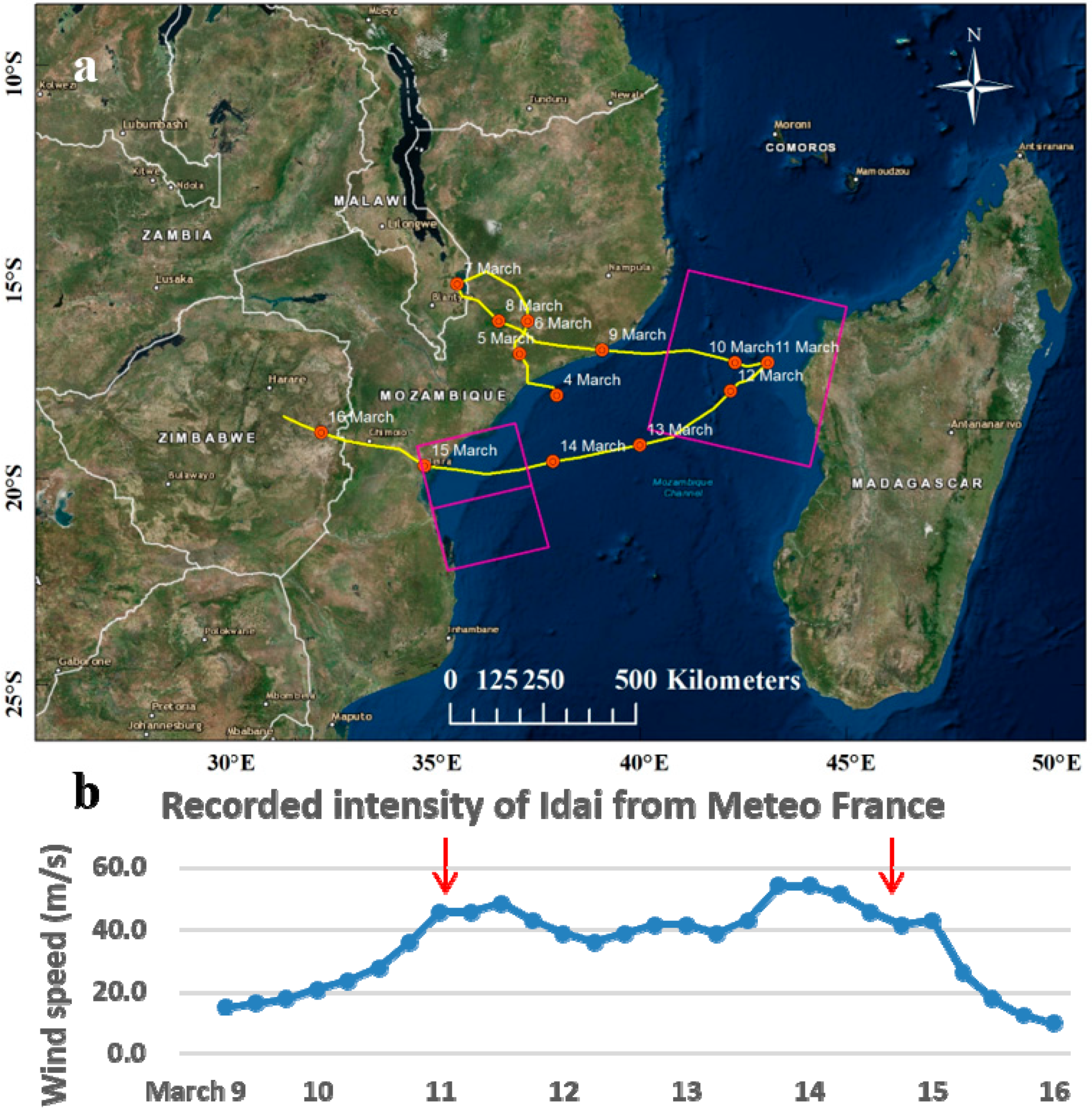
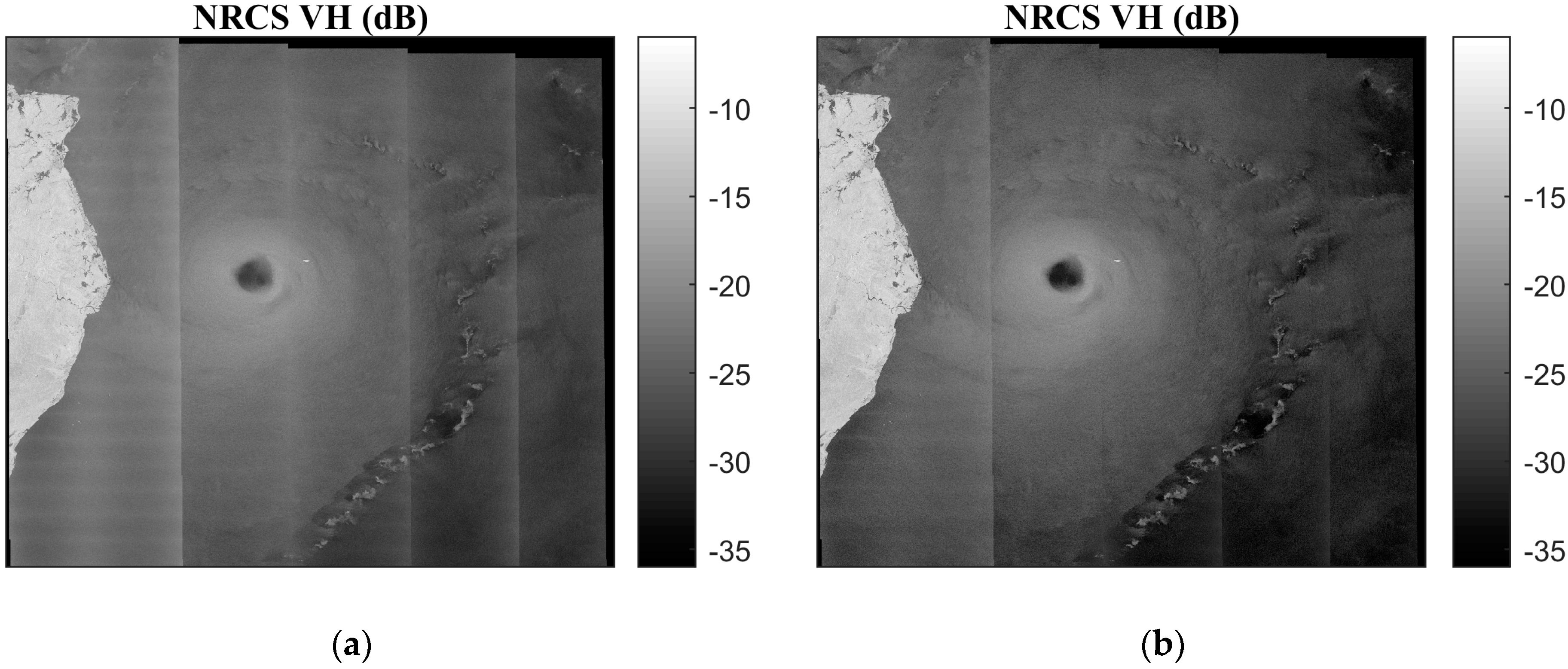
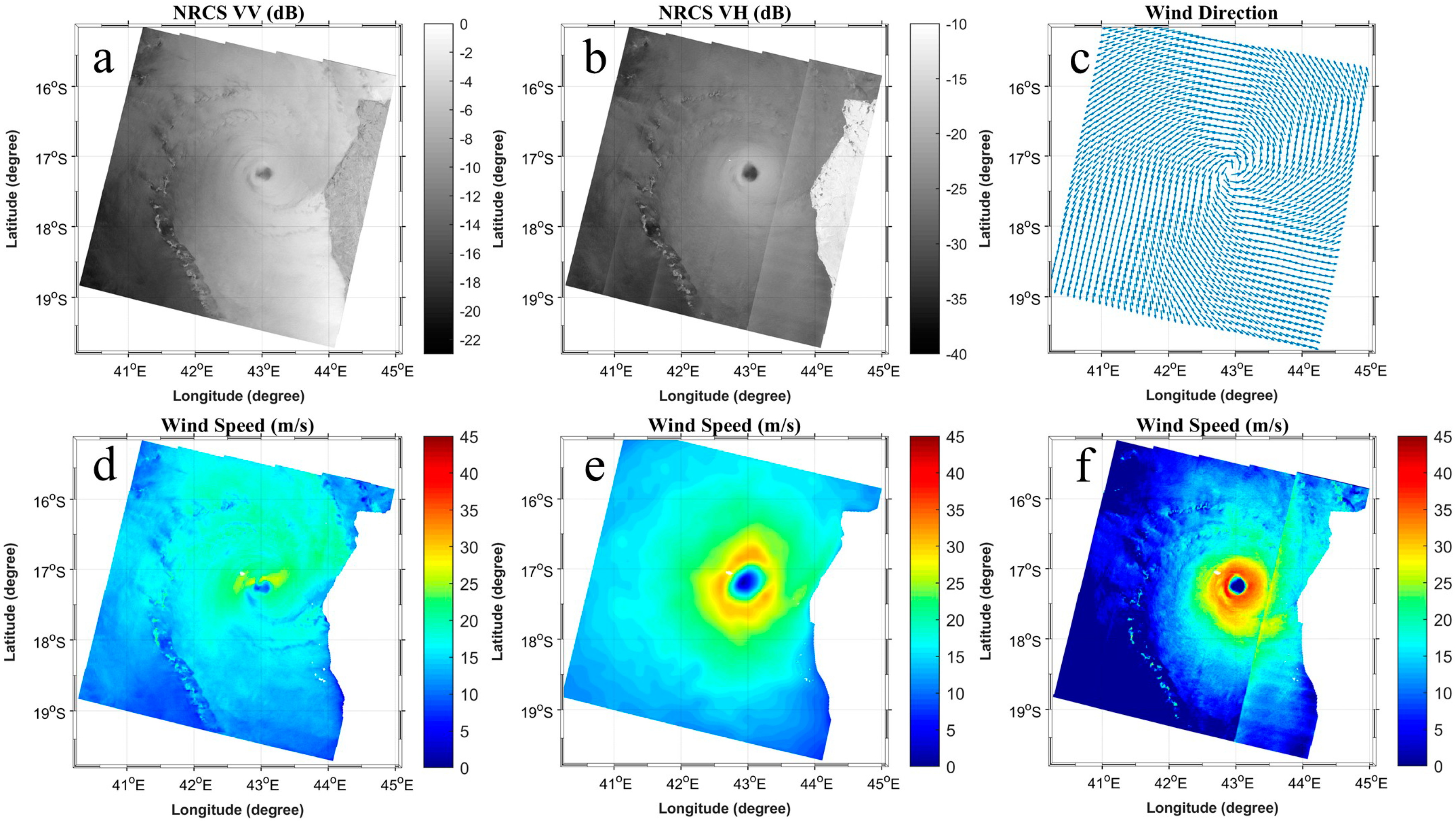
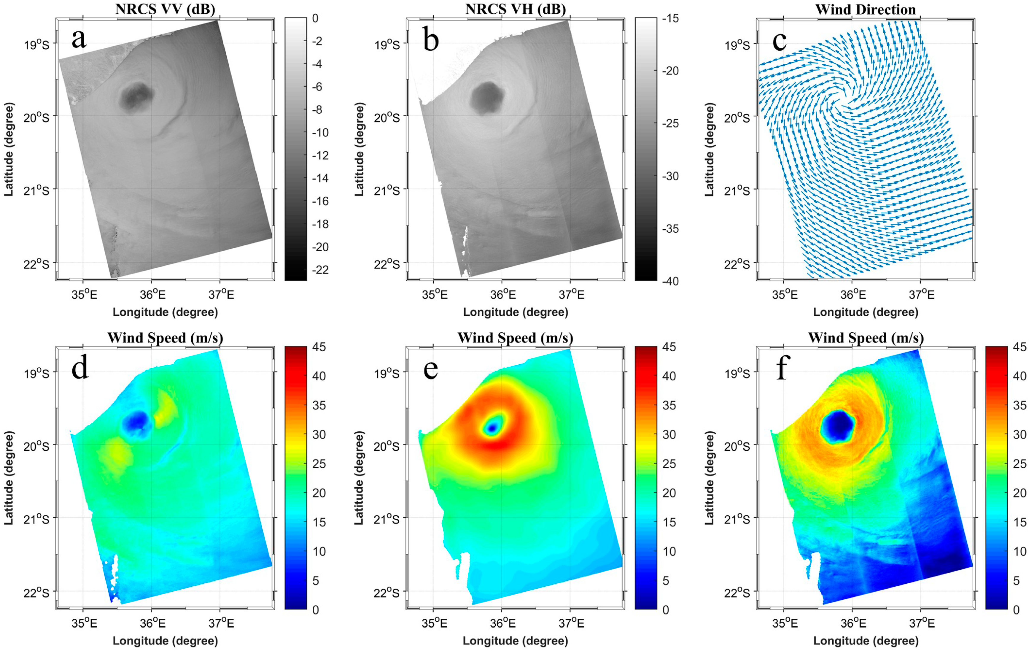
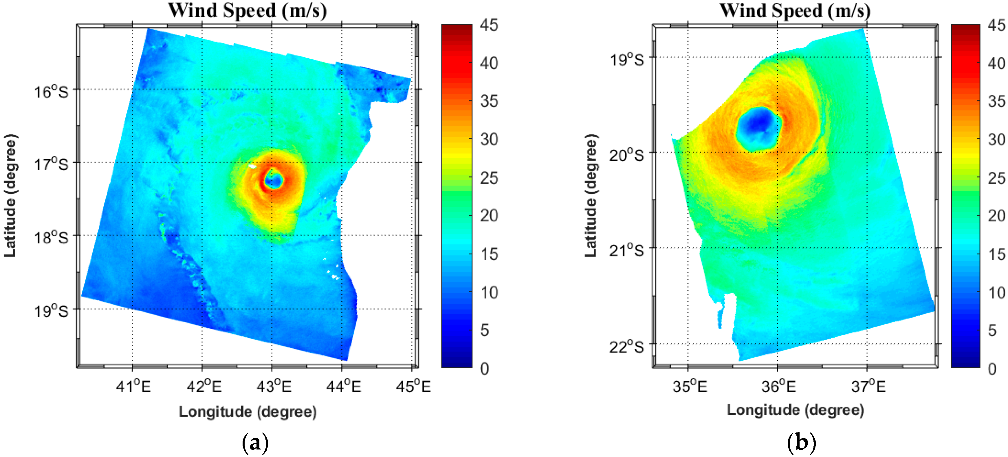
3.1. SAR Winds of Cyclone Idai

Table 1 lists the intensity (Vmax) of Idai for different co- and cross-pol GMFs, and the ECMWF model field. Although the C2014 model is clearly providing the largest intensity, the C3PO model provides a smaller difference (5.7 m/s) than the C2014 model (6.4 m/s) and CMOD7 model (6.6 m/s) compared with the track data. In contrast, C2011 performed similarly to the CMOD-IFR2 model, with a distinctly weaker intensity, as the maximum wind speeds were lower than those using the C-3PO model. In the following, we will therefore mostly focus the discussion on the retrievals using the C-3PO model, although it performs just slightly better than the C2014 model.
Figure 3a,b present the EW swath SAR-based NRCS of TC Idai from Sentinel-1 on 11 March 2019 in VV and VH polarizations, together with the collocated near surface wind speed obtained from the CMOD-IFR2 and ECMWF models in Figure 3d,e. The ECMWF wind directions from the S-1 Level-2 OCN product, as described in Section 2.1.2, are shown in Figure 3c, while the wind speeds retrieved by the C-3PO model are shown in Figure 3f. Note that by invoking the SAR VV cross-section and ECMWF direction into CMOD7 (not shown), the wind speed near the hurricane center is clearly increased, as seen in Table 1. Below 20 m/s, however, the wind field is similar to the CMOD-IFR2 retrievals. As mentioned in Section 1, the spatial resolutions of the SAR-based retrievals (Figure 3d,f) are about 1.2 km, which is much finer than the wind field derived from the microwave scatterometers and model outputs (in the order of ~10 km). Hence, the SAR-based retrievals provide much finer structural details of the TC Idai. Moreover, the GMF based on the VH radar signals (Figure 3f) retrieve strong winds in the inner core of the TC, with maximum wind speed of around 40.3 m/s, which is more close to the Vmax from RSMC La Réunion (about 45.8 m/s) than the other cross-pol models. Although the thermal noise removal and image filtering have been applied in the SAR image processing, discontinuous wind speeds are noted in EW1, especially between the first and second swaths (Figure 3f; ref Section 2.2).
Figure 4a,b illustrate the IW swath SAR-based NRCS of TC Idai acquired several hours before Idai’s landfall around the city of Beira, Mozambique, from Sentinel-1, on 14 March 2019, in VV and VH polarizations. Two SAR images with a time interval of around 25 seconds were merged to present a more complete structure of Idai. The collocated near surface wind speed from the CMOD-IFR2 and ECMWF models can be seen in Figure 4d,e. The ECMWF wind directions are given in Figure 4c, while the wind speeds retrieved by the C-3PO model are shown in Figure 4f. The SAR-based retrievals (Figure 4d,f) can provide the inner core structure of TC Idai at a finer scale. Compared with results based on the VH radar signals (Figure 4f), the area of the eyewall region in Figure 4e is significantly underestimated because of the low resolution of the ECMWF atmospheric model. Similar to the results in Figure 3, the GMF based on cross-pol NRCS (Figure 4f) can obtain a higher wind speed than the CMOD-IFR2 model (Figure 4d). Although the TC intensity based on the C-3PO model (around 37 m/s) is a bit lower compared with the Vmax from the track data (about 42.8 m/s), as shown in Figure 1b, it performs better than the CMOD models (27.6 m/s for the CMOD-IFR2 model and 33.9 m/s for the CMOD7 model).
It should be noted that the wind speeds derived by the C-3PO model in the outer regions of the cyclone were very low compared to the CMOD-IFR2, CMOD7, and ECMWF model outputs. Unrealistic wind speeds, such as zero wind speed, can be found in Figure 3f and Figure 4f. This is certainly because the low NRCS values in VH polarization are too close to the NESZ in the S-1 SAR data, as explained in Section 2.2. Therefore, the CMOD models based on co-pol radar returns are more reliable to estimate the low and moderate wind speed.

3.2. Size Parameters of Cyclone Idai

From a visual comparison of the SAR images acquired over TC Idai, it is noted that the inner core area in the VH polarization (Figure 3a and Figure 4a) is larger than in the VV polarization (Figure 3b and Figure 4b). This result is consistent with Mouche et al. [20], who found that the sensitivity of cross-pol NRCS is more than 3.5 times larger than the co-pol returns at a 3-km resolution in the presence of strong winds (120 knots). The location of the eye center within the inner core is therefore first estimated by the use of VH SAR images, according to the methods in Section 2.4. The corresponding longitudes/latitudes are 43°02’10’’E/17°14’06’’S for the 11 March 2019 image, and 35°47’51’’E/19°46’29’’S for the 14 March 2019 image.
Because the C-3PO model fails to accurately describe the outer structure of a TC (Figure 3f and Figure 4f) because of the relatively high noise floor of the S-1 data, the NRCS acquired in co-pol are used to estimate the TC parameters of the outer core. The merged wind fields based on CMOD-IFR2 for the outer core and C-3PO model for the inner core are then depicted in Figure 5a,b. In the results, strong winds were well reproduced in the inner core region, while moderate to lower winds can be seen in the outer region of the cyclone. All in all, it provides a finer view of TC Idai than the model-based estimates (Figure 3e and Figure 4e).
Based on this approach, the size parameters of TC Idai can be estimated and assessed, as depicted in Table 2. The RMW/R17 parameters were 20.3 km/120.9 km on 11 March, and growing to 39.4 km/184.4 km on 14 March. These numbers, in turn, yielded TCF estimates of 0.83 and 0.79, respectively. Based on these S-1 SAR image acquisitions of the TC Idai, the estimation of the FS4 fullness structure suggests that the TC Idai was severely destructive before hitting the coast of Mozambique, according to the conclusion by Guo and Tan [24].

4. Discussion

Although the thermal noise can be largely reduced by the denoising method provided by ESA, it is presently unable to properly remove the textural noise, especially in the first sub-swath in the EW mode Sentinel-1 GRDM product, as shown in Figure 2 and Figure 3f. The EW1 swath is therefore discarded to retrieve the wind fields (Figure 5a) in this study. Because ESA is actively working on reducing the noise level of cross-pol SAR images, a more accurate NESZ will be achieved in the future.
From Table 1 and Figure 1b, the difference of TC intensity between the C2011 model and track data is larger than 10 m/s. This large disparity is mainly because of the limited validations of high wind speeds for these models under severe weather conditions. The C-3PO model has been well validated for wind speeds of up to 40 m/s, and performs better than the C2011 model. However, the maximum wind speed in TC Idai was reported to be around 46 m/s, as shown in Figure 1b. This deficit may also possibly be explained by the joint impact of the intense rainfall and wave-breaking that may attenuate the C-band radar returns [44,45,46], because the matched data between cross-pol NRCS and SFMR observations with a rain rate higher than 10 mm/h in the C-3PO model were abandoned [38]. In the case of TC Idai, it was reported that it brought torrential rains and resulted in disastrous flooding in the city of Beira, where Idai made landfall [47]. On the contrary, the rain effects were ignored in the C2014 model, and the intensity of Idai was overestimated in comparison to the C-3PO model, as shown in Table 1. Additional inclusions of the rain effects in a cross-pol GMF will be of high importance in future efforts. Other factors that may lead to the underestimation include incorrect instrument noise floor, especially near the sub-swath boundaries, and the smoothing of the SAR image to remove speckle noise. Nevertheless, in the case of very strong winds and heavy precipitation, TC parameters, such as the TC fullness characterization, may be highly valuable for the estimation of the intensity and potential destructiveness of a TC, as shown in Section 2.
Overall, the comparison between the best track data and model results in this study presents highly favorable results, which suggest that the combination of co-pol and cross-pol radar signals is promising for representing the TC in intensity and size. High-resolution SAR data is a quite unique tool to study the fine inner-core and outer-core structure of a TC.

5. Conclusions

In this study, dual-polarization measurements from Sentinel-1 A/B SAR have been used to study the intensity and parameters of TC Idai. The results show that cross-pol images are highly favorable to study the strong winds and inner core structure of a TC. On the other hand, S-1 data fail to estimate the outer core size, such as the radius of gale-force wind (R17), because of the low signal-to-noise ratio in cross-pol data at moderate to low winds. As such, a merged wind field product based on a combination of co- and cross-pol SAR images is more favorable to estimate the TC parameters. Moreover, TC Idai revealed a very destructive FS4 fullness structure several hours before its landfall.
The strong wind fields with a fine spatial resolution that are derived from this Sentinel-1 SAR-based approach are highly important for numerical weather prediction model (such as ECMWF) validations. In particular, the TC parameters estimated by SAR may be considered in a forecasting model to improve the understanding of the TC wind structure. In addition, the SAR acquisitions can help to monitor the track of TCs, because it offers an accurate position of eye centers, which is also highly important for disaster warning before the TC landing. Moreover, after the landfall of TCs, several studies have revealed that SAR acquisitions are highly useful to generate maps of the flood extent in support of relief and rescue efforts [48,49,50]. As a result, SAR can be useful for the forecast and assessment of TC disasters not only before, but also after TCs make landfall.
The outlook on a combination of approved and planned satellite SAR-based missions and other remote sensing sensors, such as next generation scatterometers, which will also employ cross-pol radar signals, is promising. The combined data provided from these missions may be open and freely available, such as in the case of Sentinel-1, and the shorter revisit time and higher resolution will expectedly strengthen the use of SAR and other remote sensing data for extreme event monitoring and disaster reduction in the case of tropical cyclones like Idai.

Author Contributions

Conceptualization, P.Y. and X.-H.Y.; methodology, P.Y. and X.G.; software, X.Z. and L.Z.; validation, P.Y. and L.Z.; formal analysis, J.A.J. and X.Z.; writing (original draft preparation), P.Y.; writing (review and editing), P.Y., J.A.J, X.-H.Y., X.G., and X.Z.

Funding

This research was funded by the SOA Global Change and Air-Sea Interaction Project (grant numbers GASI-IPOVAI-01-04 and GASI-02-PAC-YGST2-02); the National Natural Science Foundation of China (grant numbers 91858202, 41630963, 41401370, 41476007, and 41906184); the China Postdoctoral Science Foundation (2018M642564); the Open Research Fund of State Key Laboratory of Information Engineering in Surveying, Mapping, and Remote Sensing, Wuhan University (18T08); and the Fujian Engineering Research Center for Ocean Remote Sensing Big Data (Xiamen University), Xiamen 361005, China.

Acknowledgments

The authors would like to thank the European Space Agency and RSMC La Réunion for the provision of Sentinel-1 data and best track data. Sentinel-1 data are freely available on the Copernicus Open Access Hub (https://scihub.copernicus.eu/), and the track data can be downloaded from the website of RSMC La Réunion (http://www.meteofrance.re/). Support from the European Space Agency under the ESA-MOST Dragon program is also appreciated.

Conflicts of Interest

The authors declare no conflict of interest.

References

  1. Mozambique Cyclone Idai: Four Months After. Available online: https://reliefweb.int/report/mozambique/mozambique-cyclone-idai-four-months-after-enpt (accessed on 2 September 2019).
  2. Zimbabwe: Emergency Situation Report No. 9, As of 6 June 2019. Available online: https://reliefweb.int/report/zimbabwe/zimbabwe-emergency-situation-report-no-9-6-june-2019 (accessed on 27 June 2019).
  3. Southern Africa: Cyclone Idai Snapshot (as of 12 March 2019). Available online: https://reliefweb.int/report/malawi/southern-africa-cyclone-idai-snapshot-12-march-2019 (accessed on 4 April 2019).
  4. Zhang, B.; William, P. High Wind Speed Retrieval from Multi-polarization SAR. In Hurricane Monitoring with Spaceborne Synthetic Aperture Radar; Li, X., Ed.; Springer: Singapore, 2017; pp. 85–98. [Google Scholar]
  5. Zhang, B.; Perrie, W.; Zhang, J.A.; Uhlhorn, E.W.; He, Y. High-Resolution Hurricane Vector Winds from C-Band Dual-Polarization SAR Observations. J. Atmos. Ocean. Technol. 2014, 31, 272–286. [Google Scholar] [CrossRef]
  6. Quilfen, Y.; Chapron, B.; Elfouhaily, T.; Katsaros, K.; Tournadre, J. Observation of tropical cyclones by high-resolution scatterometry. J. Geophys. Res. Ocean. 1998, 103, 7767–7786. [Google Scholar] [CrossRef]
  7. Hersbach, H. Comparison of C-Band Scatterometer CMOD5.N Equivalent Neutral Winds with ECMWF. J. Atmos. Ocean. Technol. 2010, 27, 721–736. [Google Scholar] [CrossRef]
  8. Hersbach, H.; Stoffelen, A.; de Haan, S. An improved C-band scatterometer ocean geophysical model function: CMOD5. J. Geophys. Res. Ocean. 2007, 112. [Google Scholar] [CrossRef]
  9. Stoffelen, A.; Anderson, D. Scatterometer data interpretation: Estimation and validation of the transfer function CMOD4. J. Geophys. Res. Ocean. 1997, 102, 5767–5780. [Google Scholar] [CrossRef]
  10. Stoffelen, A.; Verspeek, J.A.; Vogelzang, J.; Verhoef, A. The CMOD7 Geophysical Model Function for ASCAT and ERS Wind Retrievals. IEEE J. Sel. Top. Appl. Earth Obs. Remote Sens. 2017, 10, 2123–2134. [Google Scholar] [CrossRef]
  11. De Kloe, J.; Stoffelen, A.; Verhoef, A. Improved Use of Scatterometer Measurements by Using Stress-Equivalent Reference Winds. IEEE J. Sel. Top. Appl. Earth Obs. Remote Sens. 2017, 10, 2340–2347. [Google Scholar] [CrossRef]
  12. Donnelly, W.J.; Carswell, J.R.; McIntosh, R.E.; Chang, P.S.; Wilkerson, J.; Marks, F.; Black, P.G. Revised ocean backscatter models at C and Ku band under high-wind conditions. J. Geophys. Res. Ocean. 1999, 104, 11485–11497. [Google Scholar] [CrossRef]
  13. Quilfen, Y.; Prigent, C.; Chapron, B.; Mouche, A.A.; Houti, N. The potential of QuikSCAT and WindSat observations for the estimation of sea surface wind vector under severe weather conditions. J. Geophys. Res. Ocean. 2007, 112. [Google Scholar] [CrossRef]
  14. Shen, H.; He, Y.; Perrie, W. Speed ambiguity in hurricane wind retrieval from SAR imagery. Int. J. Remote Sens. 2009, 30, 2827–2836. [Google Scholar] [CrossRef]
  15. Donelan, M.A.; Haus, B.K.; Reul, N.; Plant, W.J.; Stiassnie, M.; Graber, H.C.; Brown, O.B.; Saltzman, E.S. On the limiting aerodynamic roughness of the ocean in very strong winds. Geophys. Res. Lett. 2004, 31. [Google Scholar] [CrossRef]
  16. Koch, W. Directional analysis of SAR images aiming at wind direction. IEEE Trans. Geosci. Remote Sens. 2004, 42, 702–710. [Google Scholar] [CrossRef]
  17. Kudryavtsev, V.; Kozlov, I.; Chapron, B.; Johannessen, J.A. Quad-polarization SAR features of ocean currents. J. Geophys. Res. Ocean. 2014, 119, 6046–6065. [Google Scholar] [CrossRef]
  18. Hwang, P.A.; Zhang, B.; Perrie, W. Depolarized radar return for breaking wave measurement and hurricane wind retrieval. Geophys. Res. Lett. 2010, 37, L01604. [Google Scholar] [CrossRef]
  19. Fois, F.; Hoogeboom, P.; Le Chevalier, F.; Stoffelen, A. Future Ocean Scatterometry: On the Use of Cross-Polar Scattering to Observe Very High Winds. IEEE Trans. Geosci. Remote Sens. 2015, 53, 5009–5020. [Google Scholar] [CrossRef]
  20. Mouche, A.A.; Chapron, B.; Zhang, B.; Husson, R. Combined Co- and Cross-Polarized SAR Measurements Under Extreme Wind Conditions. IEEE Trans. Geosci. Remote Sens. 2017, 55, 6746–6755. [Google Scholar] [CrossRef]
  21. Stoffelen, A.; Aaboe, S.; Calvet, J.; Cotton, J.; De Chiara, G.; Saldana, J.F.; Mouche, A.A.; Portabella, M.; Scipal, K.; Wagner, W. Scientific Developments and the EPS-SG Scatterometer. IEEE Trans. Geosci. Remote Sens. 2017, 10, 2086–2097. [Google Scholar] [CrossRef]
  22. Merrill, R.T. A Comparison of Large and Small Tropical Cyclones. Mon. Weather Rev. 1984, 112, 1408–1418. [Google Scholar] [CrossRef]
  23. Kimball, S.K.; Mulekar, M.S. A 15-Year Climatology of North Atlantic Tropical Cyclones. Part I: Size Parameters. J. Clim. 2004, 17, 3555–3575. [Google Scholar] [CrossRef]
  24. Guo, X.; Tan, Z. Tropical cyclone fullness: A new concept for interpreting storm intensity. Geophys. Res. Lett. 2017, 44, 4324–4331. [Google Scholar] [CrossRef]
  25. Cazals, C.; Rapinel, S.; Frison, P.; Bonis, A.; Mercier, G.; Mallet, C.; Corgne, S.; Rudant, J. Mapping and Characterization of Hydrological Dynamics in a Coastal Marsh Using High Temporal Resolution Sentinel-1A Images. Remote Sens. 2016, 8, 570. [Google Scholar] [CrossRef]
  26. Sentinel-1 Product Definition. Available online: https://sentinels.copernicus.eu/documents/247904/1877131/Sentinel-1-Product-Definition (accessed on 19 May 2019).
  27. Li, X. The first Sentinel-1 SAR image of a typhoon. Acta Oceanol. Sin. 2015, 34, 1–2. [Google Scholar] [CrossRef]
  28. ECMWF Meteorological Bulletin 3.1. Available online: https://www.ecmwf.int/sites/default/files/3.1.pdf (accessed on 19 October 2019).
  29. Sentinel-1 Ocean Wind Fields (OWI) Algorithm Definition. Available online: https://sentinel.esa.int/documents/247904/3861173/Sentinel-1-Ocean-Wind-Fields-OWI-ATBD.pdf (accessed on 19 June 2019).
  30. Park, J.; Won, J.; Korosov, A.A.; Babiker, M.; Miranda, N. Textural Noise Correction for Sentinel-1 TOPSAR Cross-Polarization Channel Images. IEEE Trans. Geosci. Remote Sens. 2019, 57, 4040–4049. [Google Scholar] [CrossRef]
  31. Thermal Denoising of Products Generated by the S-1 IPF. Available online: https://sentinel.esa.int/documents/247904/2142675/Thermal-Denoising-of-Products-Generated-by-Sentinel-1-IPF (accessed on 19 July 2019).
  32. Karvonen, J. Baltic Sea Ice Concentration Estimation Using SENTINEL-1 SAR and AMSR2 Microwave Radiometer Data. IEEE Trans. Geosci. Remote Sens. 2017, 55, 2871–2883. [Google Scholar] [CrossRef]
  33. Tan, W.; Li, J.; Xu, L.; Chapman, M.A. Semiautomated Segmentation of Sentinel-1 SAR Imagery for Mapping Sea Ice in Labrador Coast. IEEE J. Sel. Top. Appl. Earth Obs. Remote Sens. 2018, 11, 1419–1432. [Google Scholar] [CrossRef]
  34. Vachon, P.W.; Wolfe, J. C-Band Cross-Polarization Wind Speed Retrieval. IEEE Geosci. Remote Sens. Lett. 2011, 8, 456–459. [Google Scholar] [CrossRef]
  35. Zhang, B.; Perrie, W. Cross-Polarized Synthetic Aperture Radar: A New Potential Measurement Technique for Hurricanes. Bull. Am. Meteorol. Soc. 2012, 93, 531–541. [Google Scholar] [CrossRef]
  36. Van Zadelhoff, G.J.; Stoffelen, A.; Vachon, P.W.; Wolfe, J.; Horstmann, J.; Belmonte Rivas, M. Retrieving hurricane wind speeds using cross-polarization C-band measurements. Atmos. Meas. Tech. 2014, 7, 437–449. [Google Scholar] [CrossRef]
  37. Hwang, P.A.; Stoffelen, A.; van Zadelhoff, G.; Perrie, W.; Zhang, B.; Li, H.; Shen, H. Cross-polarization geophysical model function for C-band radar backscattering from the ocean surface and wind speed retrieval. J. Geophys. Res. Ocean. 2015, 120, 893–909. [Google Scholar] [CrossRef]
  38. Zhang, G.; Li, X.; Perrie, W.; Hwang, P.A.; Zhang, B.; Yang, X. A Hurricane Wind Speed Retrieval Model for C-Band RADARSAT-2 Cross-Polarization ScanSAR Images. IEEE Trans. Geosci. Remote Sens. 2017, 55, 4766–4774. [Google Scholar] [CrossRef]
  39. Horstmann, J.; Falchetti, S.; Wackerman, C.; Maresca, S.; Caruso, M.J.; Graber, H.C. Tropical Cyclone Winds Retrieved From C-Band Cross-Polarized Synthetic Aperture Radar. IEEE Trans. Geosci. Remote Sens. 2015, 53, 2887–2898. [Google Scholar] [CrossRef] [Green Version]
  40. Portabella, M.; Stoffelen, A.; Johannessen, J.A. Toward an optimal inversion method for synthetic aperture radar wind retrieval. J. Geophys. Res. Ocean. 2002, 107, 1–13. [Google Scholar] [CrossRef]
  41. Christiansen, M.B.; Koch, W.; Horstmann, J.; Hasager, C.B.; Nielsen, M. Wind resource assessment from C-band SAR. Remote Sens. Environ. 2006, 105, 68–81. [Google Scholar] [CrossRef] [Green Version]
  42. Zhou, X.; Yang, X.; Li, Z.; Yu, Y.; Bi, H.; Ma, S.; Li, X. Estimation of tropical cyclone parameters and wind fields from SAR images. Sci. China Earth Sci. 2013, 56, 1977–1987. [Google Scholar] [CrossRef]
  43. Xu, Q.; Li, X.; Bao, S.; Zhang, G. Tropical Cyclone Eye Morphology and Extratropical-Cyclone-Forced Mountain Lee Waves on SAR Imagery. In Hurricane Monitoring with Spaceborne Synthetic Aperture Radar; Li, X., Ed.; Springer: Singapore, 2017; pp. 373–398. [Google Scholar]
  44. Alpers, W.; Zhang, B.; Mouche, A.; Zeng, K.; Chan, P.W. Rain footprints on C-band synthetic aperture radar images of the ocean–Revisited. Remote Sens. Environ. 2016, 187, 169–185. [Google Scholar] [CrossRef]
  45. Tournadre, J.; Quilfen, Y. Impact of rain cell on scatterometer data: 1. Theory and modeling. J. Geophys. Res. Ocean 2003, 108. [Google Scholar] [CrossRef]
  46. Zhang, G.; Li, X.; Perrie, W.; Zhang, B.; Wang, L. Rain effects on the hurricane observations over the ocean by C-band Synthetic Aperture Radar. J. Geophys. Res. Ocean. 2016, 121, 14–26. [Google Scholar] [CrossRef] [Green Version]
  47. Tropical Cyclone IDAI Impact Overview-Emergency Response Coordination Centre (ERCC)-DG ECHO Daily Map 18/03/2019. Available online: https://reliefweb.int/sites/reliefweb.int/files/resources/ECDM_20190318_TC_IDAI_update.pdf (accessed on 10 April 2019).
  48. Chung, H.; Liu, C.; Cheng, I.; Lee, Y.; Shieh, M. Rapid Response to a Typhoon-Induced Flood with an SAR-Derived Map of Inundated Areas: Case Study and Validation. Remote Sens. 2015, 7, 11954–11973. [Google Scholar] [CrossRef] [Green Version]
  49. Chini, M.; Hostache, R.; Giustarini, L.; Matgen, P. A Hierarchical Split-Based Approach for Parametric Thresholding of SAR Images: Flood Inundation as a Test Case. IEEE Trans. Geosci. Remote Sens. 2017, 55, 6975–6988. [Google Scholar] [CrossRef]
  50. Pulvirenti, L.; Pierdicca, N.; Boni, G.; Fiorini, M.; Rudari, R. Flood Damage Assessment Through Multitemporal COSMO-SkyMed Data and Hydrodynamic Models: The Albania 2010 Case Study. IEEE J. Sel. Top. Appl. Earth Obs. Remote Sens. 2014, 7, 2848–2855. [Google Scholar] [CrossRef]
Figure 1. (a) The track of Tropical Cyclone (TC) Idai, and the pink boxes show the locations of Sentinel-1 scenes; (b) recorded intensity of Idai by Meteo France from 9 March 2019 to 16 March 2019. The red arrows point to the time when the synthetic aperture radar (SAR) images were acquired.
Remotesensing 11 02837 g001
Figure 2. The Sentinel-1 (S-1) SAR extra wide (EW) swath ground range detected medium (GRDM) product on 11 March 2019 before (a) and after (b) thermal noise removal in VH channel.
Remotesensing 11 02837 g002
Figure 3. TC Idai captured by a Sentinel-1 dual-polarization SAR image at 02:43 UTC on 11 March 2019 showing (a) VV polarization and (b) VH polarization, both with the NRCS (dB), given by the grey-scale values; (c) ECMWF wind directions recorded in the S-1 Level-2 ocean (OCN) product; (d) wind speeds based on ECMWF wind directions and the CMOD-IFR2 model; (e) wind speeds from ECMWF; and (f) wind speeds retrieved by the C-3PO model, all with the color bar denoting the wind speeds (m/s).
Remotesensing 11 02837 g003
Figure 4. TC Idai captured by Sentinel-1 dual-polarization SAR image at 16:04 UTC on 14 March 2019 showing (a) VV polarization and (b) VH polarization, both with the NRCS (dB) given by the grey-scale values; (c) ECMWF wind directions recorded in the S-1 Level-2 OCN product; (d) wind speeds based on the ECMWF wind directions and the CMOD-IFR2 model; (e) wind speeds from ECMWF; and (f) wind speeds retrieved by the C-3PO model, all with the color bar denoting the wind speeds (m/s).
Remotesensing 11 02837 g004
Figure 5. Combined wind speeds by CMOD-IFR2 and C-3PO model on (a) 11 March 2019 and (b) 14 March 2019.
Remotesensing 11 02837 g005
Table 1. Intensity of TC Idai estimated by different models and track data from Regional Specialized Meteorological Centre (RSMC) La Réunion. ECMWF—European Centre for Medium-Range Weather Forecast.
TimeTC Intensity-Vmax(m/s)
C2011C2014C-3POCMOD-IFR2CMOD7ECMWFBest track
02:43 11 March30.753.540.327.45031.645.8
16:04 14 March28.547.936.927.633.939.342.8
Table 2. Size parameters of TC Idai derived from the combined approach and compared to the track data from the RSMC La Réunion. RMW—radiuses of maximum wind; TCF—TC fullness.
TimeRMW (km)R17 (km)TCF
Combined Method02:43 11 March20.3120.90.83
16:04 14 March39.4184.40.79
Track Data00:00 11 March19
06:00 11 March19
12:00 14 March56
18:00 14 March37

