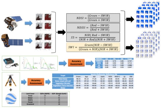
Development and Evaluation of a New “Snow Water Index (SWI)” for Accurate Snow Cover Delineation
Abstract
1. Introduction
2. Material and Methods
2.1. Test Area
2.2. Data Used
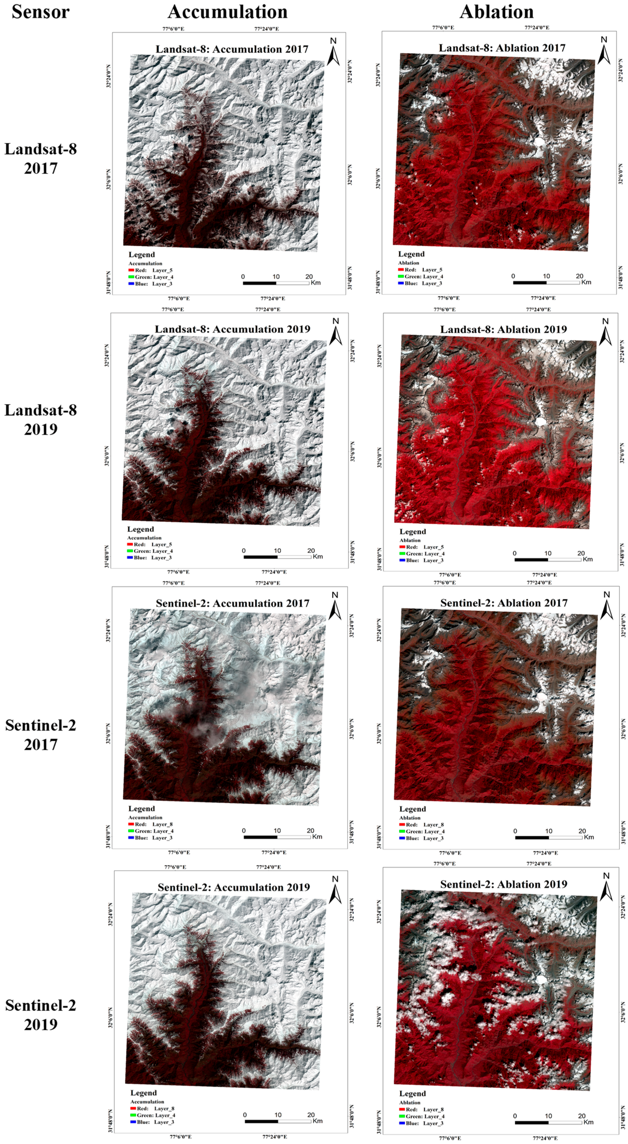
2.2.1. Digital Satellite Image Dataset
2.2.2. Field Survey and Ground Observations
Spectro-Radiometer Observations
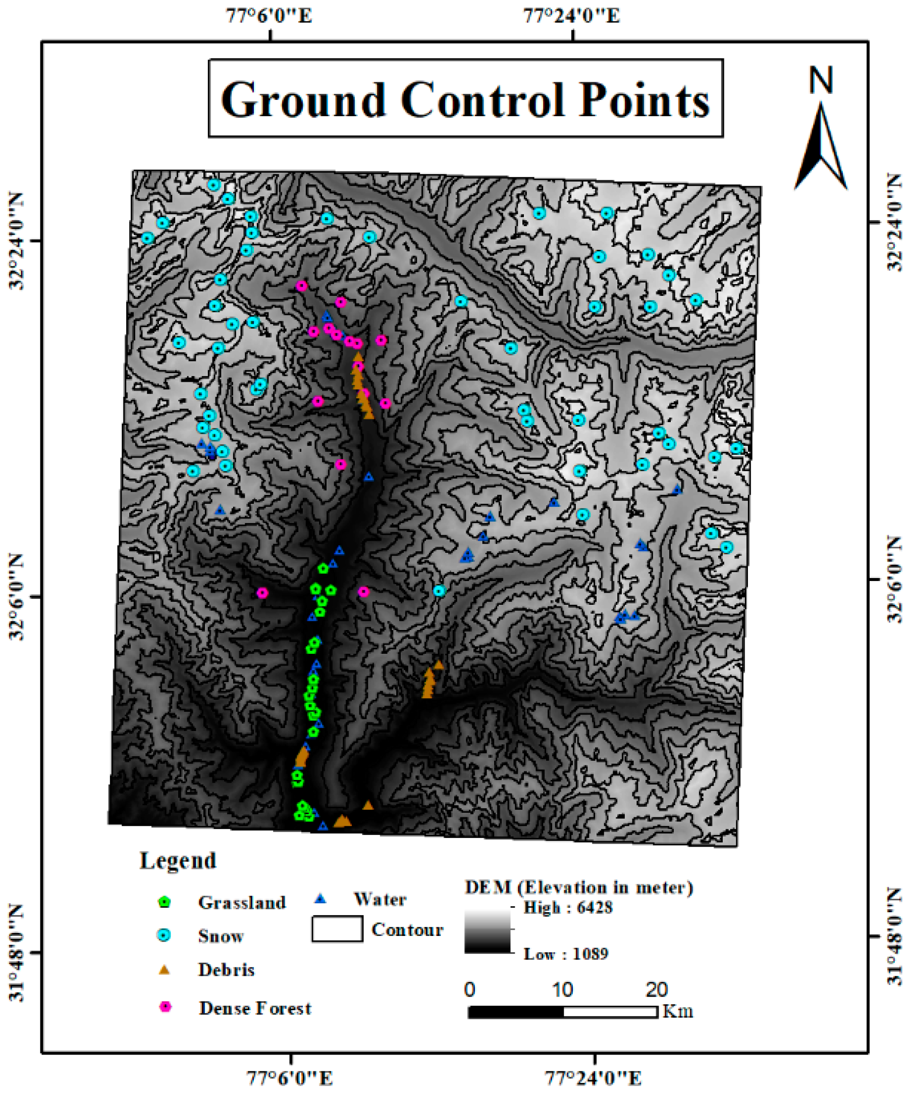
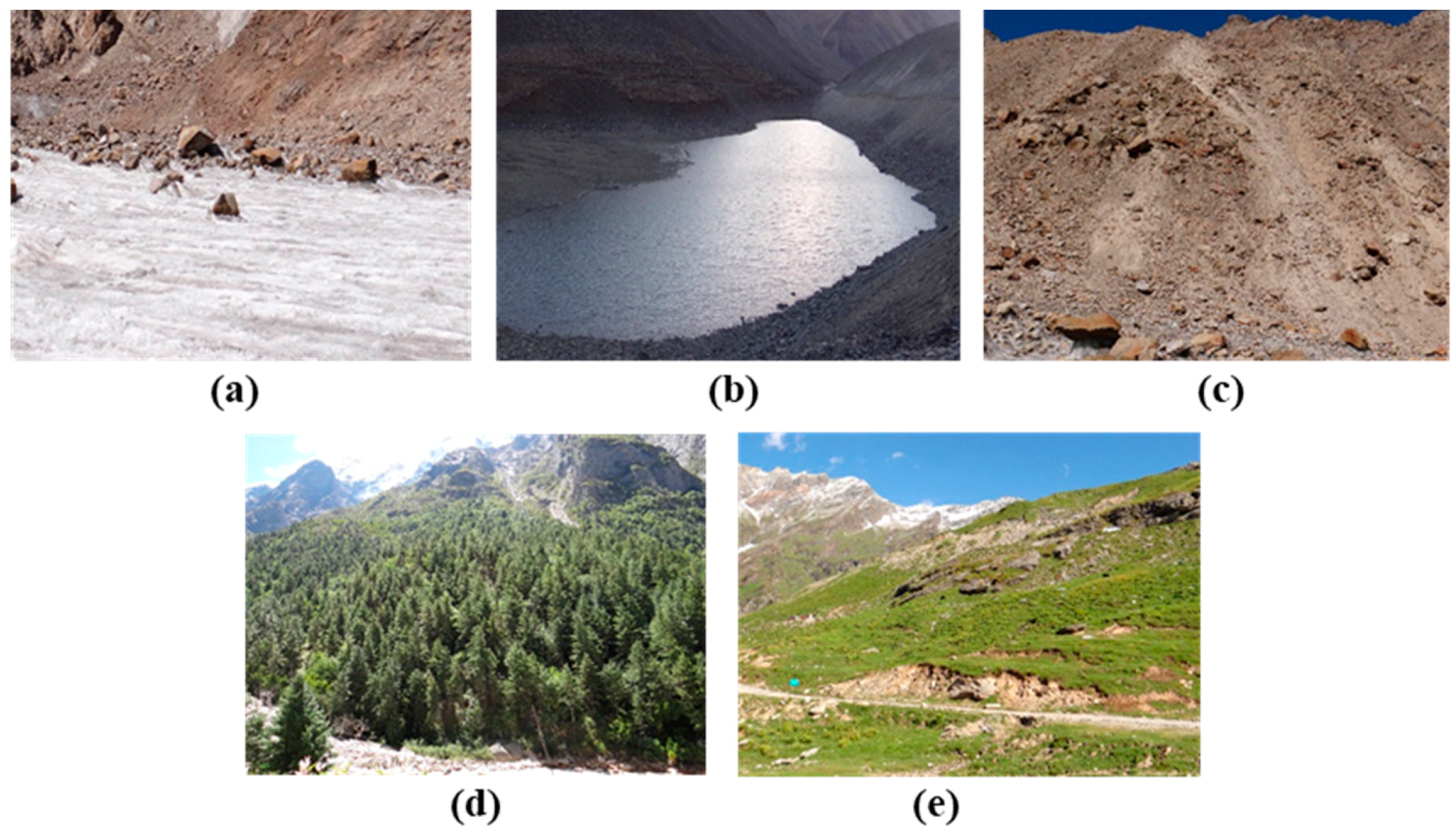
Ground Control Points (GCPs)
2.3. Methodology
2.3.1. Normalized Difference Snow Index (NDSI)
2.3.2. S3 Index
2.3.3. Normalized Difference Snow and Ice Index (NDSII-1)
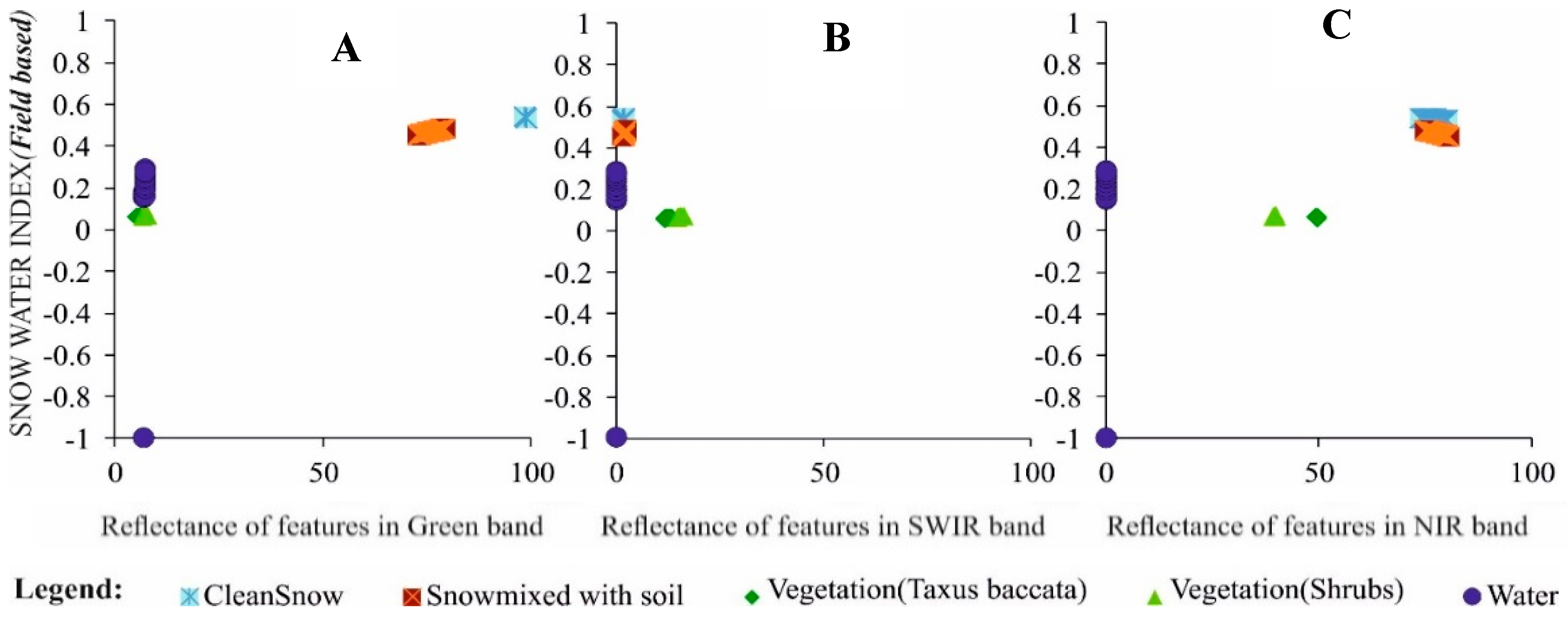
2.3.4. Snow Water Index (SWI)
2.4. Accuracy Assessment
2.4.1. Index Thresholding
2.4.2. Spectro-Radiometer Validation
2.4.3. GCPs (Ground Control Points) Validation
3. Results and Discussion
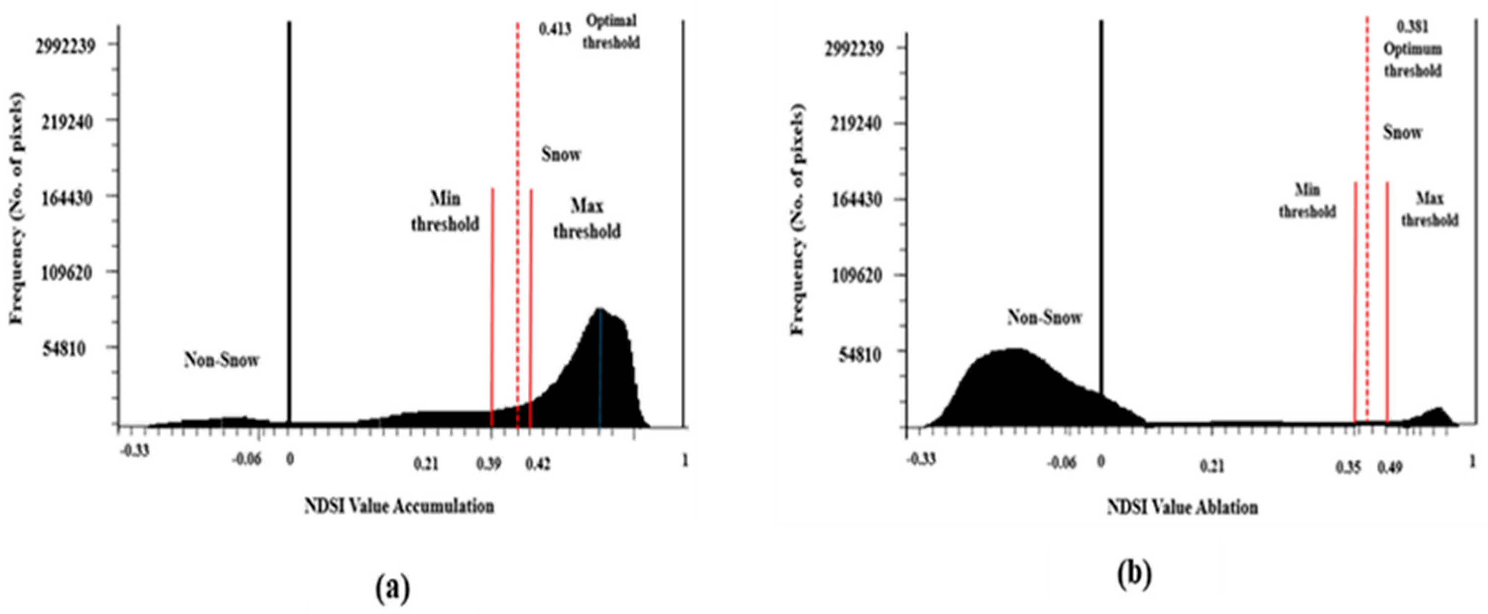
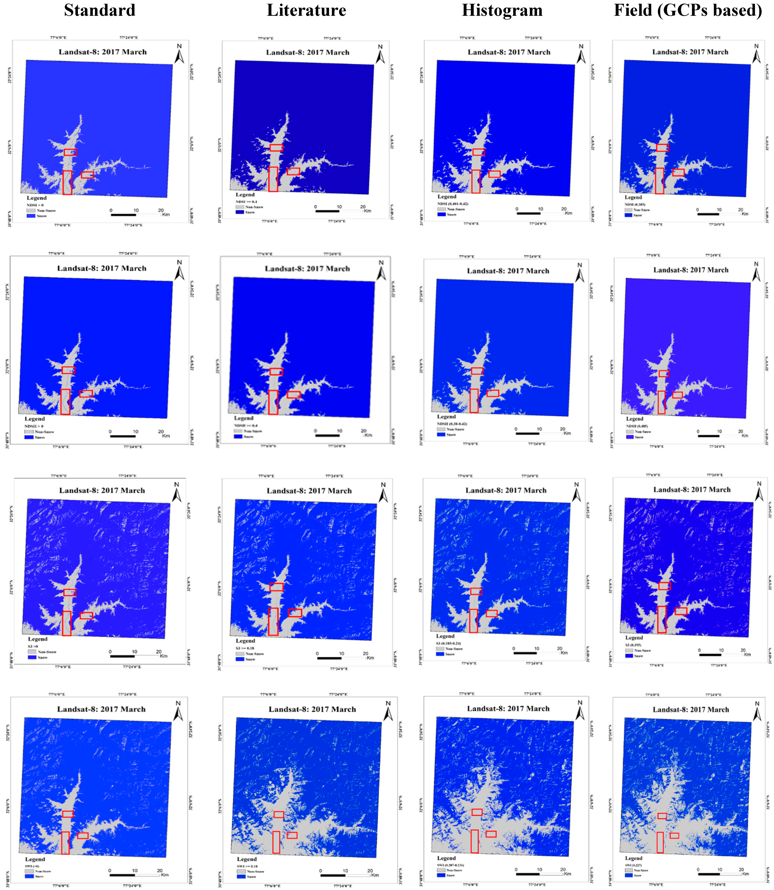
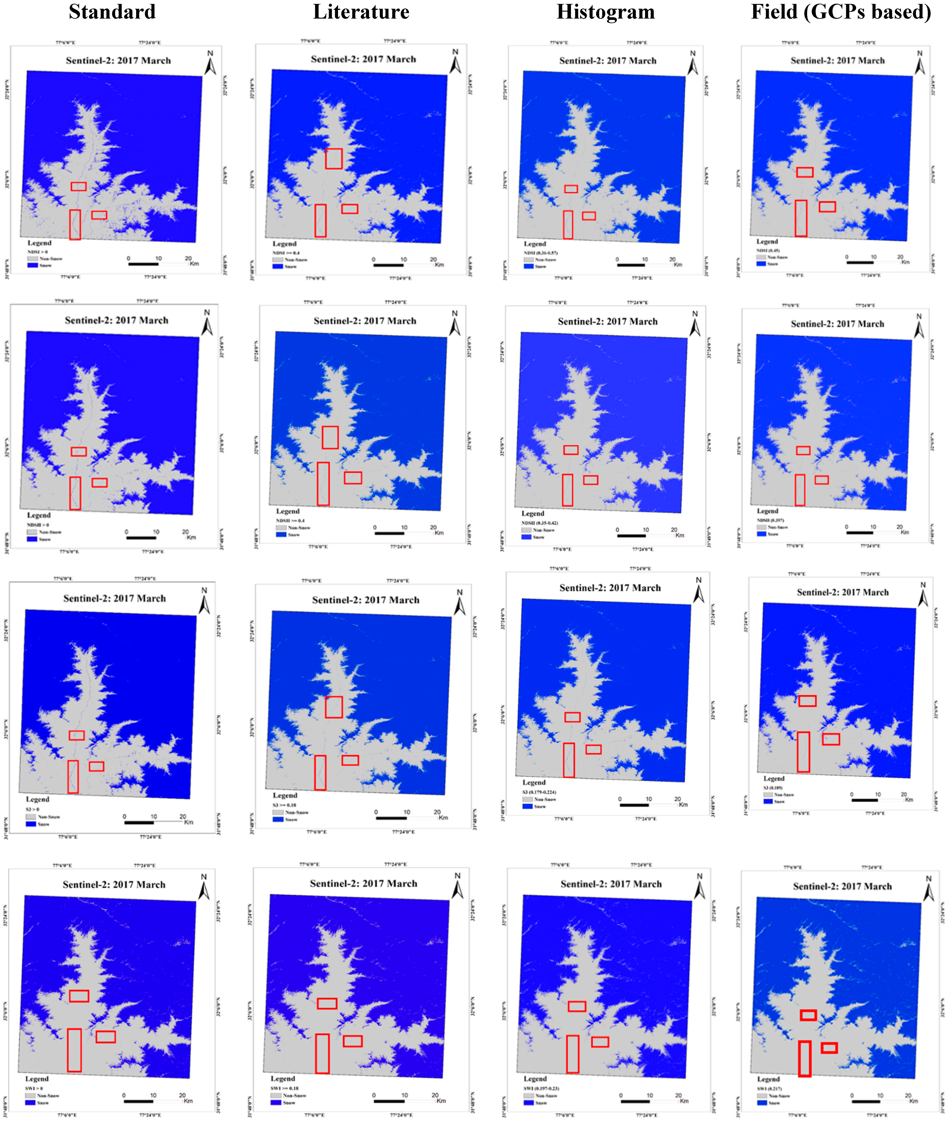
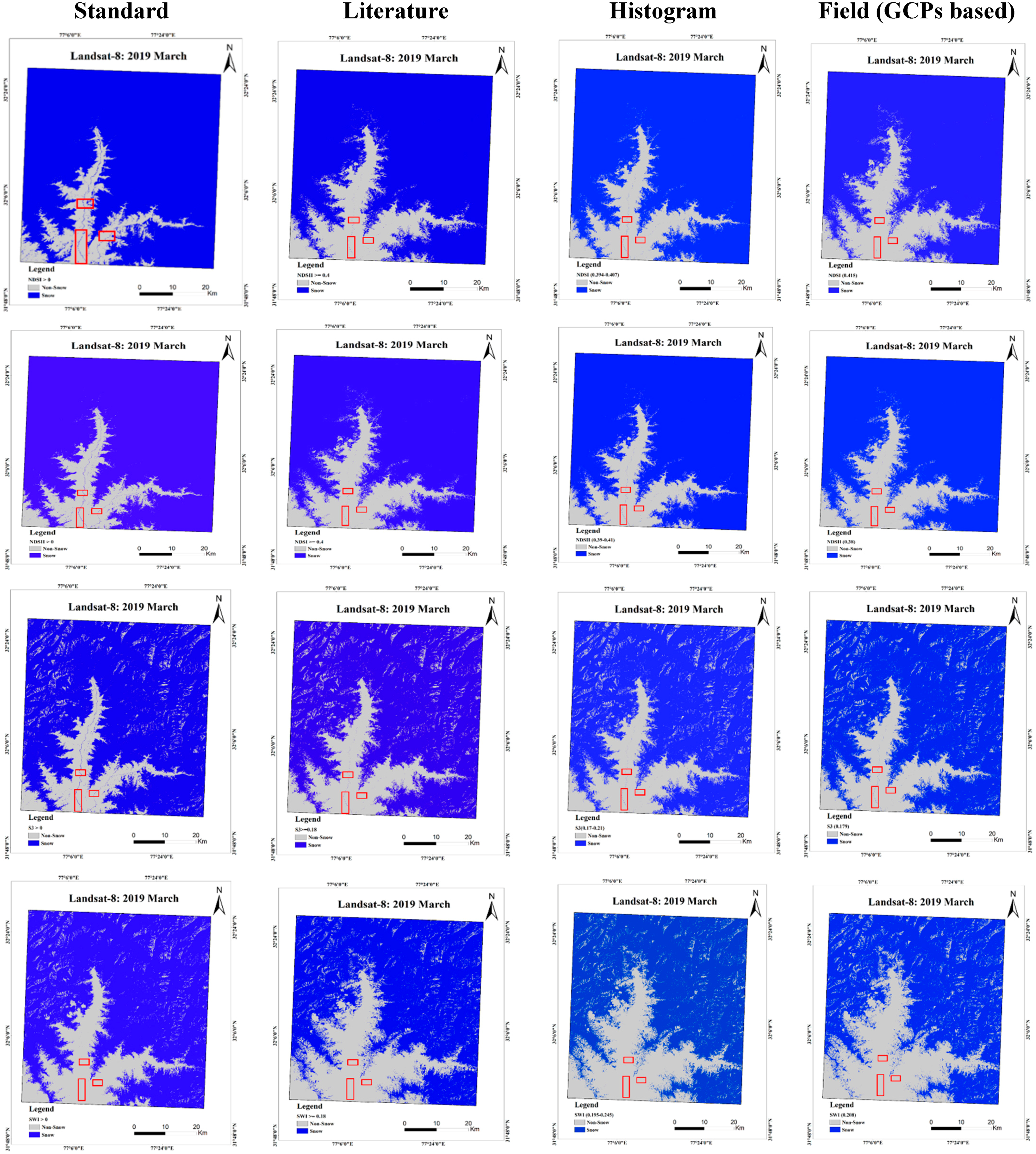
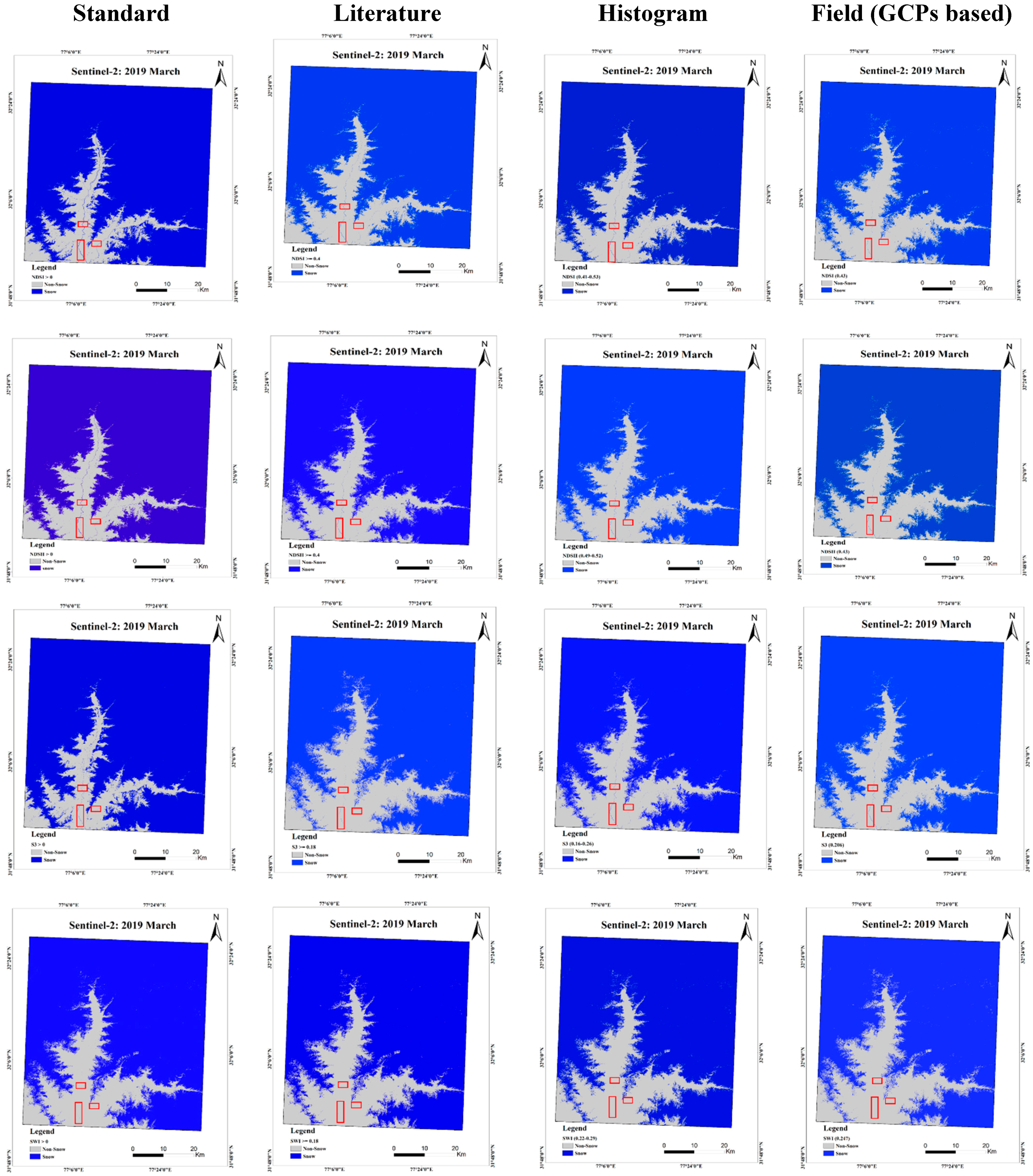
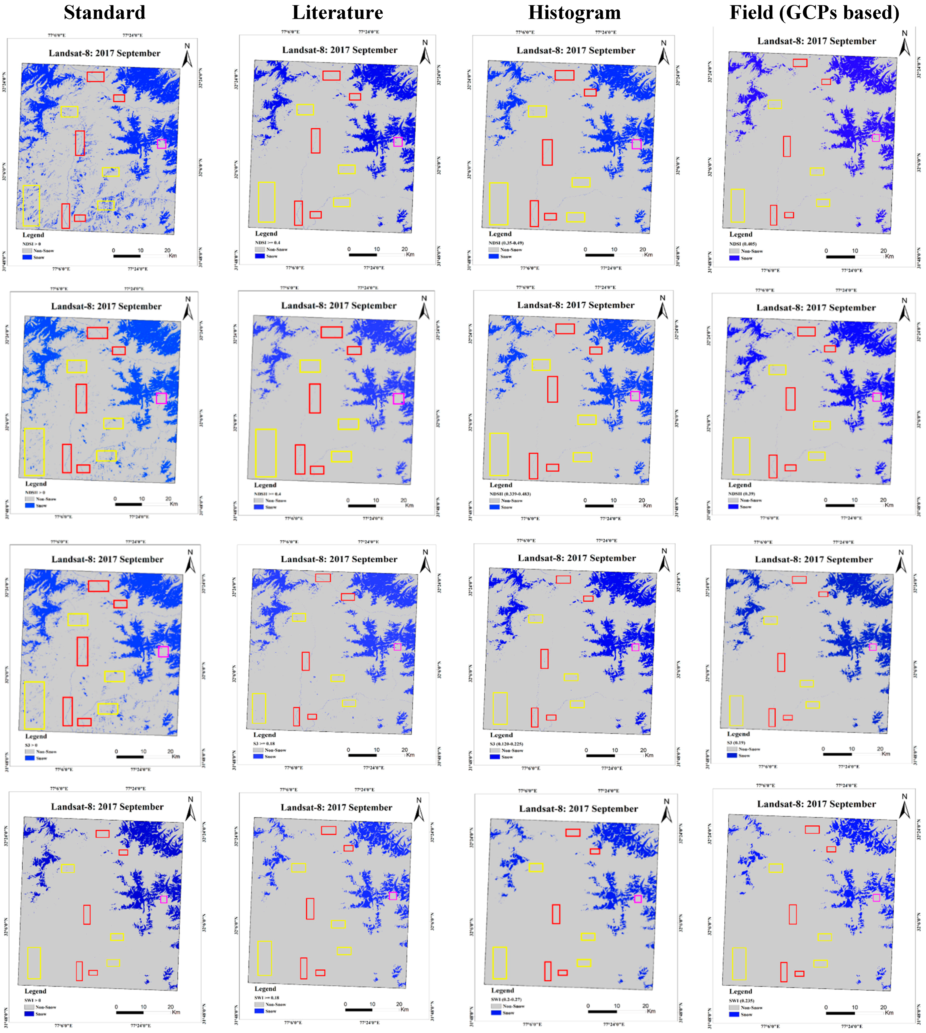
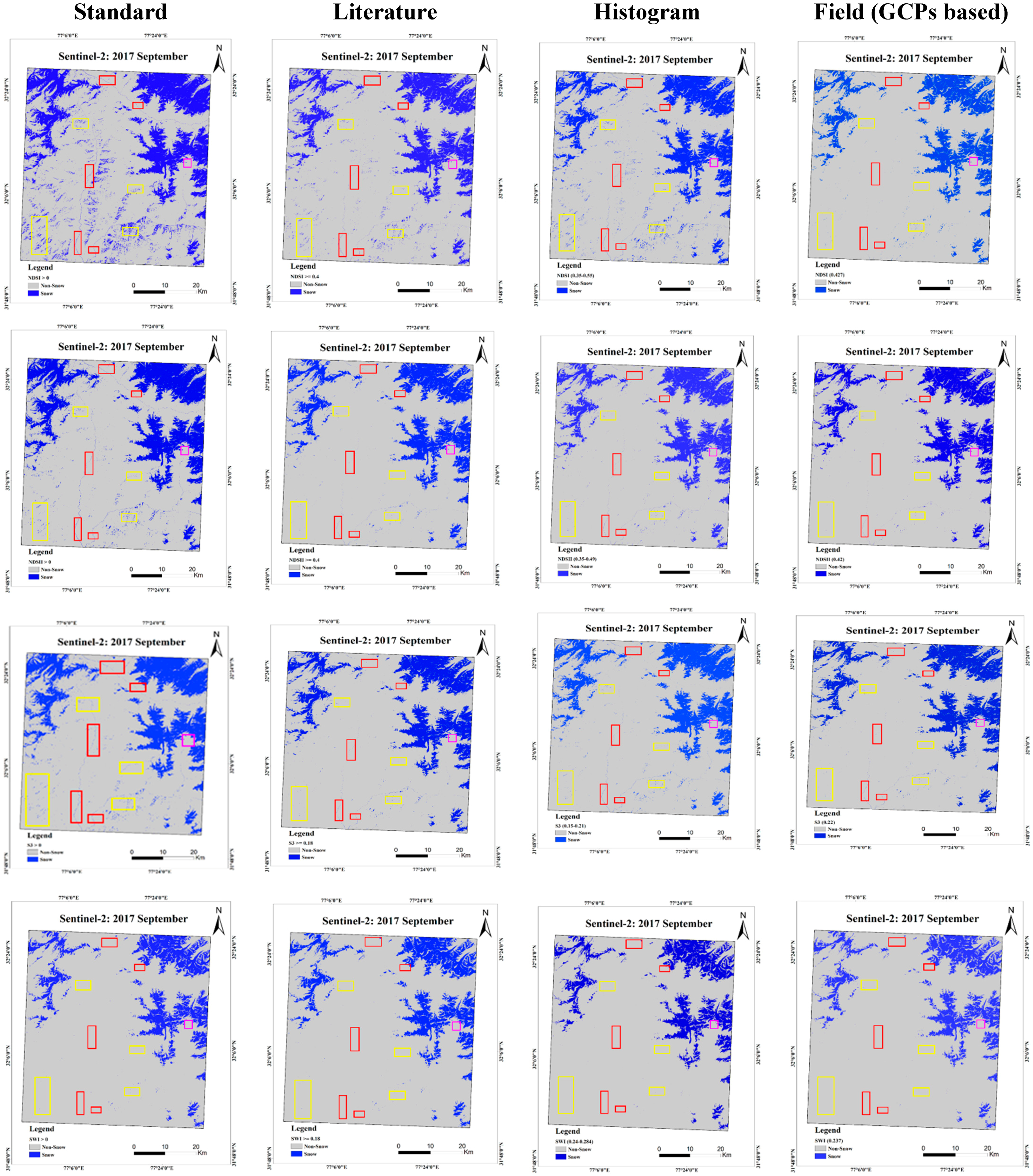
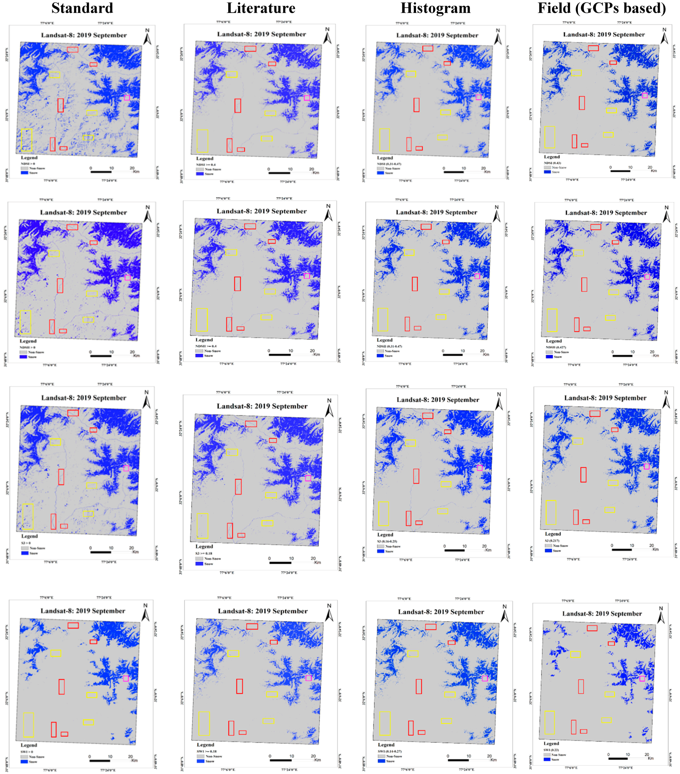
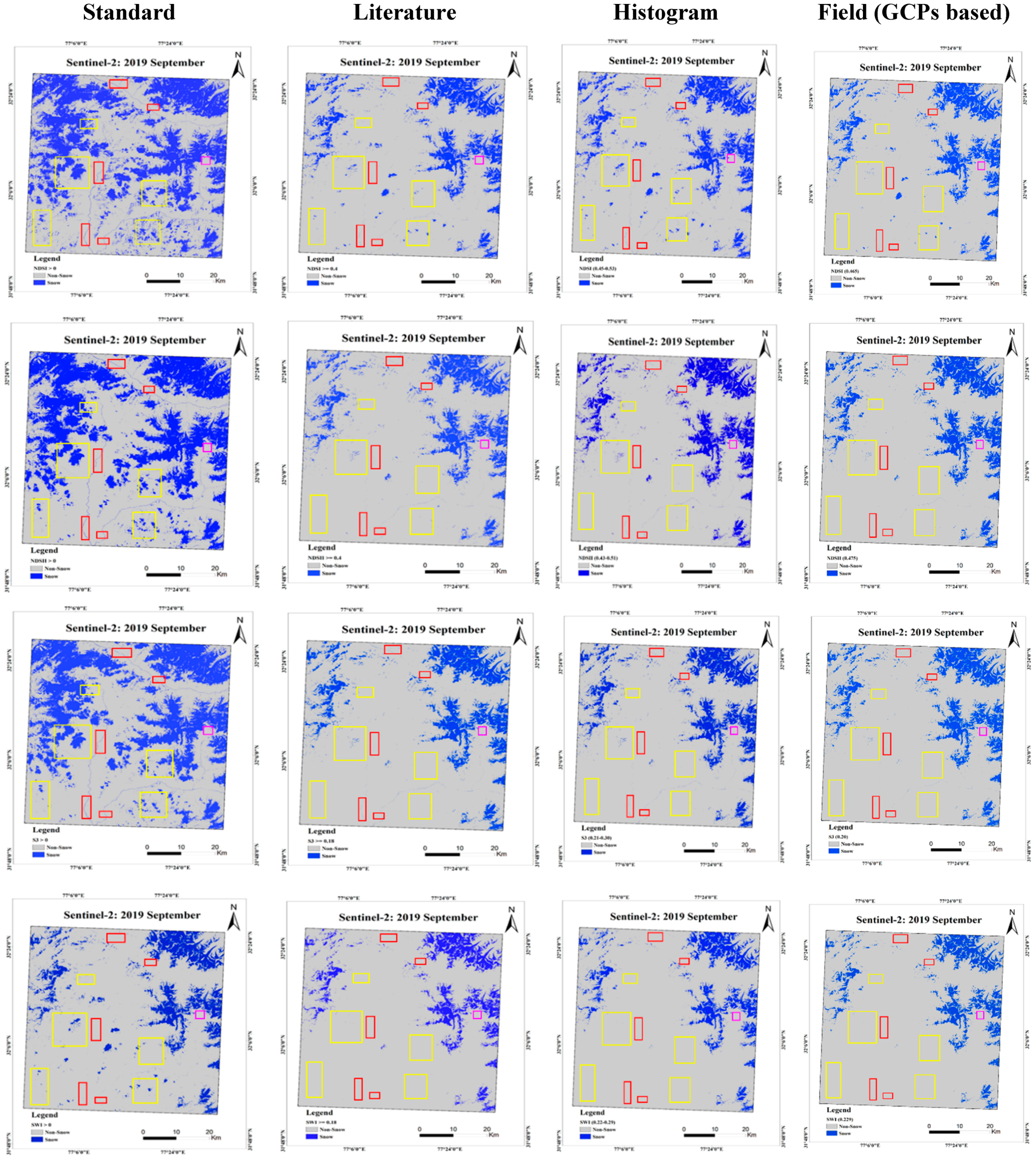
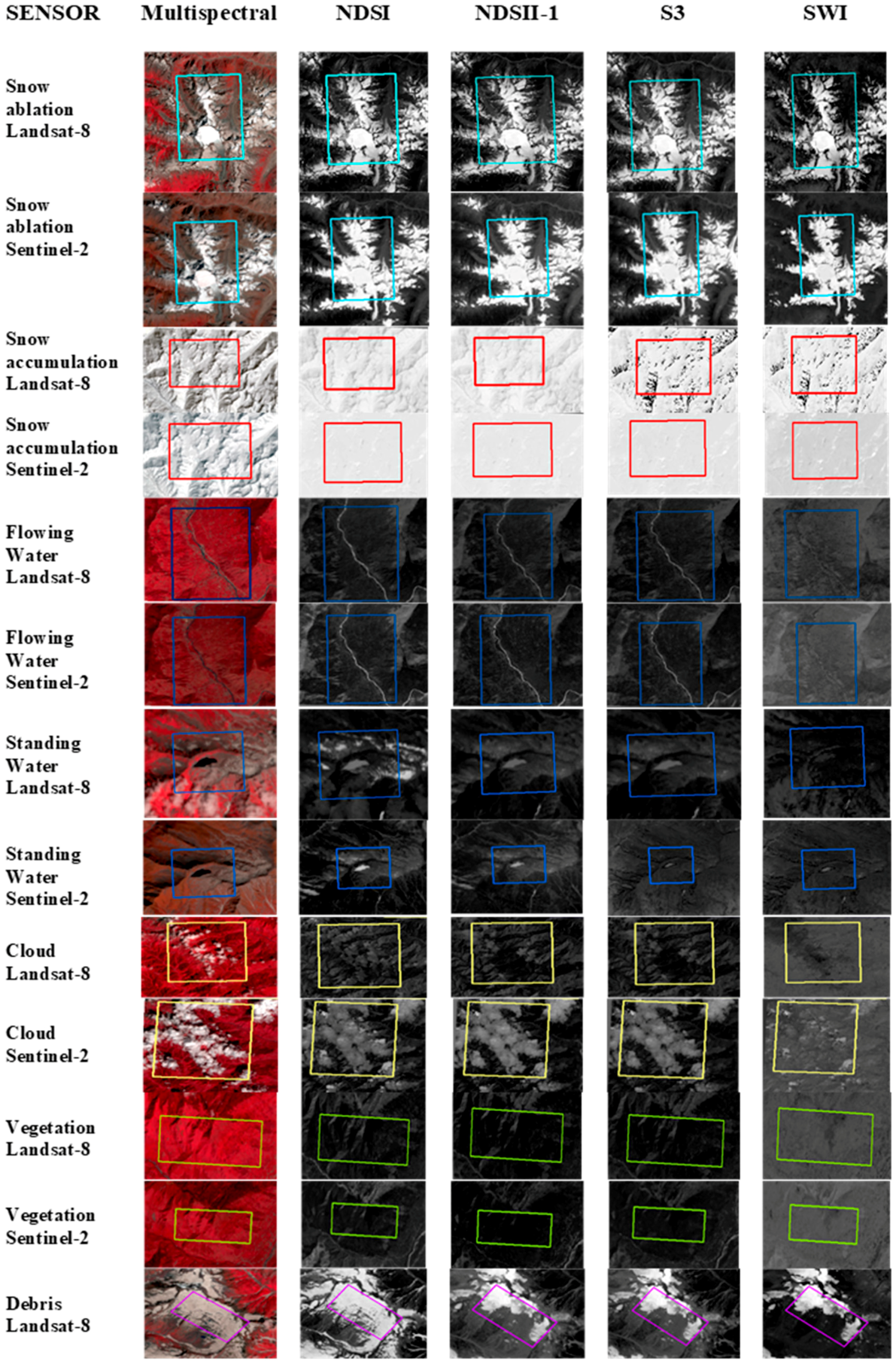
3.1. Image Thresholding and Snow/Non-Snow Classification
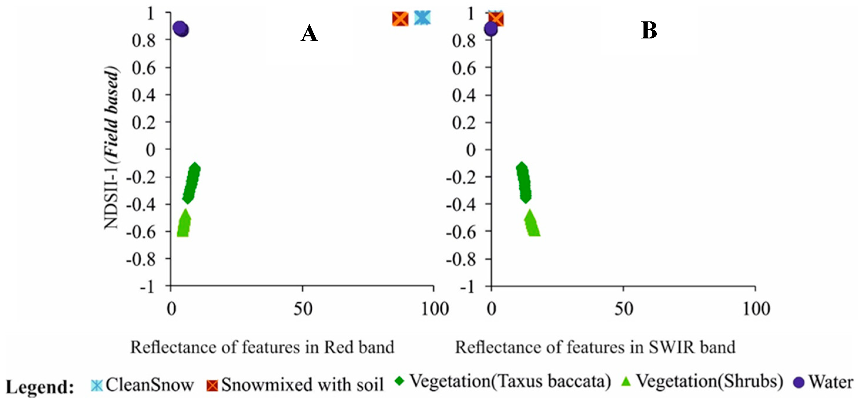
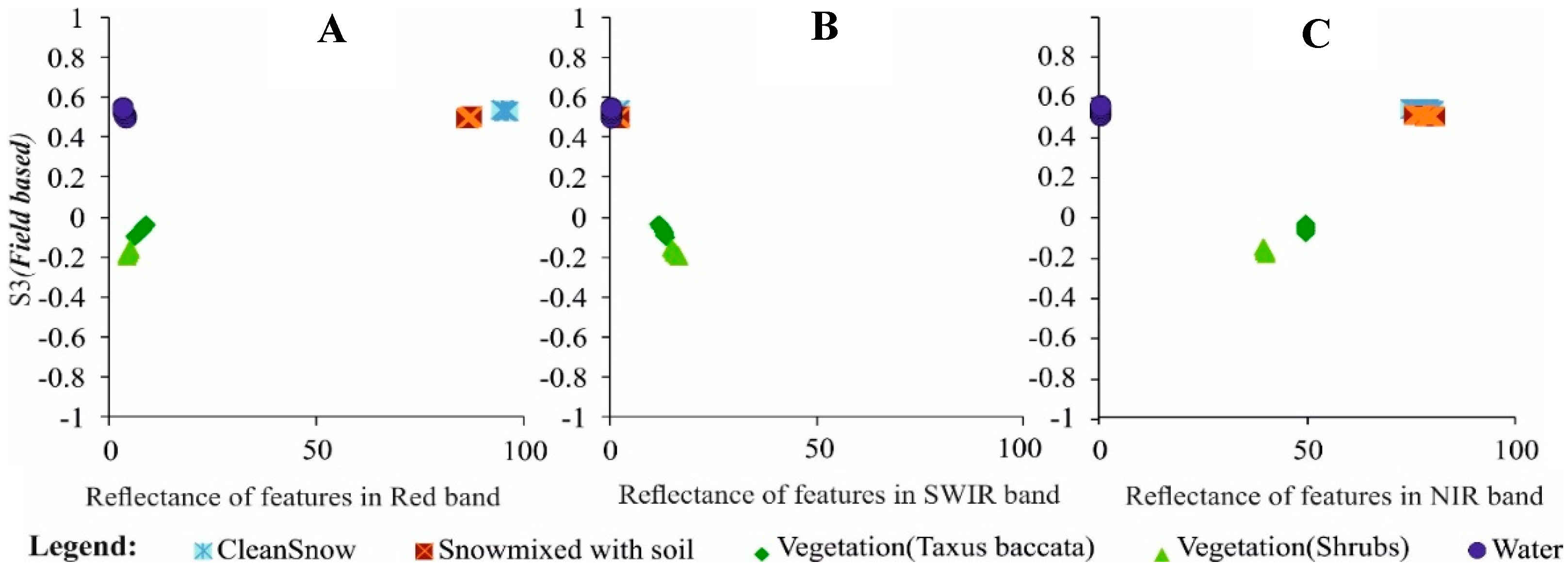
3.2. Validation Using Spectroradiometer Observations
3.3. Validation Using GCPs
4. Conclusions
Author Contributions
Funding
Acknowledgments
Conflicts of Interest
References
- Aggarwal, K.C.; Kumar, V.; Dass, T. Snowmelt run-off for a catchment of Beas basin. In Proceedings of the First National Symp. on Seasonal Snow Cover, SASE, Manali, India, 28–30 April 1983; pp. 43–63. [Google Scholar]
- Jain, S.K.; Goswami, A.; Saraf, A.K. Snowmelt runoff modelling in a Himalayan basin with the aid of satellite data. Int. J. Remote Sens. 2010, 31, 6603–6618. [Google Scholar] [CrossRef]
- SAC & MoEF. Snow and Glaciers of the Himalayas: Inventory and Monitoring (Work Carried out by Space Applications Centre, ISRO in Collaboration with other Organisations); Discussion Paper II; Space Applications Centre, ISRO, Ahmedabad and Ministry of Environment and Forests: New Delhi, India, 2010.
- SAC 2011. Snow and Glaciers of the Himalayas (Study Carried out Under the Joint Project of Ministry of Environment and Forests and Department of Space, Government of India); Space Applications Centre, ISRO: Ahmedabad, India, 2011; p. 258.
- Bonan, G. Ecological Climatology, Concepts and Applications; Cambridge University Press: New York, NY, USA, 2002. [Google Scholar]
- Foster, J.L.; Chang, A.T.C. Snow cover. In Atlas of Satellite Observations Related to Global Change; Gurney, R.J., Parkinson, C.L., Foster, J.L., Eds.; Cambridge University Press: Cambridge, UK, 1993; pp. 361–370. [Google Scholar]
- Jain, S.K.; Goswami, A.; Saraf, A.K. Accuracy assessment of MODIS, NOAA and IRS data in snow cover mapping under Himalayan conditions. Int. J. Remote Sens. 2008, 29, 5863–5878. [Google Scholar] [CrossRef]
- Klein, A.G.; Hall, D.K.; Nolin, A.W. Development of a prototype snow albedo algorithm for the NASA MODIS instrument. In Proceedings of the 57th Eastern Snow Conference, New York, NY, USA, 17–19 May 2000; pp. 15–17. [Google Scholar]
- Zhao, H.; Fernandes, R.; Wang, X.; Key, J.; Qu, X.; Hall, A. Controls on Northern Hemisphere snow albedo feedback quantified using satellite Earth observations. Geophys. Res. Lett. 2009, 36. [Google Scholar] [CrossRef]
- Lu, S.; Oki, K.; Omasa, K. Mapping snow cover using AVHRR/NDVI 10-day composite data. J. Agric. Meteorol. 2005, 60, 1215–1218. [Google Scholar] [CrossRef]
- Monson, R.K.; Burns, S.P.; Williams, M.W.; Delany, A.C.; Weintraub, M.; Lipson, D.A. The contribution of beneath-snow soil respiration to total ecosystem respiration in a high-elevation, subalpine forest. Glob. Biogeochem. Cycles 2003, 20. [Google Scholar] [CrossRef]
- Isard, S.A.; Schaetzl, R.J.; Andresen, J.A. Soils cool as climate warms in the great lakes region: 1951–2000. Ann. Assoc. Am. Geogr. 2007, 97, 467–476. [Google Scholar] [CrossRef]
- Darmody, R.G.; Thorn, C.E.; Schlyter, P.; Dixon, J.C. Relationships of Vegetation Distribution to Soil Properties in Kärkevagge, Swedish Lapland. Arct. Antarct. Alp. Res. 2004, 36, 21–32. [Google Scholar] [CrossRef]
- Löffler, J. Snow cover dynamics, soil moisture variability and vegetation ecology in high mountain catchments of central Norway. Hydrol. Process. 2005, 19, 2385–2405. [Google Scholar] [CrossRef]
- Potts, H.L. A photographic survey method of forecasting runoff. Trans.-Am. Geophys. Union 1944, 25, 153–194. [Google Scholar] [CrossRef]
- Miller, D.H. Snow Cover Depletion and Runoff. Snow Hydrology; USA Army Corps of Engineers: Portland, ME, USA, 1953.
- Namias, J. Snowfall over eastern United States: Factors leading to its monthly and seasonal variations. Weatherwise 1960, 13, 238–247. [Google Scholar] [CrossRef]
- Namias, J. Influences of abnormal surface heat sources and sinks on atmospheric behaviour. In Proceedings of the Int. Symp. on Numerical Weather Prediction, Tokyo, Japan, March 1962; pp. 615–627. [Google Scholar]
- Lamb, H.H. Climate, Present, Past and Future; Methuen and Co. Ltd.: London, UK, 1972; Volume 1. [Google Scholar]
- Kukla, G.J.; Kukla, H.J. Increased Surface Albedo in the Northern Hemisphere: Did satellites warn of the weather troubles of 1972 and 1973. Science 1974, 183, 709–714. [Google Scholar] [CrossRef]
- Dickson, R.R.; Namias, J. North American influences on the circulation and climate of the North Atlantic sector. Mon. Weather Rev. 1976, 104, 1255–1265. [Google Scholar] [CrossRef]
- Kavzoglu, T.; Colkesen, I. A kernel functions analysis for support vector machines for land cover classification. Int. J. Appl. Earth Obs. Geoinf. 2009, 11, 352–359. [Google Scholar] [CrossRef]
- Singh, P.; Singh, V.P. Snow and Glacier Hydrology; Kluwer Academic Publishers: Dordrecht, The Netherlands, 2011; p. 742. [Google Scholar]
- O’brian, H.W.; Munis, R.H. Red and Near-Infrared Spectral Reflectance of Snow; Research Report 332; U.S. Army Cold Regions Research and Engineering Laboratory: Hanover, NH, USA, 1975.
- Warren, S.G.; Wiscombe, W.J. A model for the spectral albedo of snow. I: Pure snow. J. Atmos. Sci. 1980, 37, 2712–2733. [Google Scholar] [CrossRef]
- Warren, S.G.; Wiscombe, W.J. A model for the spectral albedo of snow. II: Snow containing atmospheric aerosols. J. Atmos. Sci. 1980, 37, 2734–2745. [Google Scholar] [CrossRef]
- Warren, S.G. Optical properties of snow. Rev. Geophys. 1982, 20, 67–89. [Google Scholar] [CrossRef]
- Zeng, Q.; Cao, M.; Feng, X.; Liang, F.; Chen, X.; Sheng, W. A study of spectral reflection characteristics for snow, ice and water in the north of China. Hydrol. Appl. Remote Sens. Remote Data Transm. 1984, 145, 451–462. [Google Scholar]
- Hall, D.K.; Riggs, G.A.; Salomonson, V.V. Development of methods for mapping global snow-cover using moderate resolution spectroradiometer data. Remote Sens. Environ. 1995, 54, 127–140. [Google Scholar] [CrossRef]
- Williams, R.S., Jr.; Hall, D.K. Glaciers. In Atlas of Satellite Observations Related to Global Change; Gurney, R.J., Foster, J.L., Parkinson, C.L., Eds.; Cambridge University Press: New York, NY, USA, 1993; pp. 401–422. [Google Scholar]
- Kulkarni, A.V.; Rathore, B.P.; Singh, S.K. Monitoring of seasonal snow cover in the Western Himalaya. In Proceedings of the International Workshop on Snow, Ice, Glaciers and Avalanches, Mumbai, India, 7–9 January 2008; pp. 85–92. [Google Scholar]
- Köning, M.; Sturm, M. Mapping snow distribution in the Alaskan Arctic using aerial photography and topographic relationships. Water Resour. Res. 1998, 34, 3471–3483. [Google Scholar] [CrossRef]
- Foppa, N.; Seiz, G. Inter-annual variations of snow days over Switzerland from 2000–2010 derived from MODIS satellite data. Cryosphere 2012, 6, 331–342. [Google Scholar] [CrossRef]
- Singh, P.; Haritashya, U.K.; Singh, V.P. Encyclopedia of Snow, Ice and Glaciers; Springer: Berlin, Germany, 2011; pp. 245–256. [Google Scholar]
- Gupta, R.P.; Haritashya, U.K.; Singh, P. Mapping dry/wet snow cover in the Indian Himalayas using IRS multispectral imagery. Remote Sens. Environ. 2005, 97, 458–469. [Google Scholar] [CrossRef]
- Kour, R.; Patel, N.; Krishna, A.P. Assessment of relationship between snow cover characteristics (SGI and SCI) and snow cover indices (NDSI and S3). Earth Sci. Inform. 2015, 8, 317–326. [Google Scholar] [CrossRef]
- Sharma, R.C.; Tateishi, R.; Hara, K. A new water-resistant snow index for the detection and mapping of snow cover on a global scale. Int. J. Remote Sens. 2016, 37, 2706–2723. [Google Scholar] [CrossRef]
- Shimamura, Y.; Izumi, T.; Matsumaya, H. Evaluation of a useful method to identify snow-covered areas under vegetation–comparisons among a newly proposed snow index, normalized difference snow index and visible reflectance. Int. J. Remote Sens. 2006, 27, 4867–4884. [Google Scholar] [CrossRef]
- Xiao, X.; Shen, Z.; Qin, X. Assessing the potential of VEGETATION sensor data for mapping snow and ice cover: A normalized difference snow and ice index. Int. J. Remote Sens. 2001, 22, 2479–2487. [Google Scholar] [CrossRef]
- Keshri, A.; Shukla, A.; Gupta, R.P. ASTER ratio indices for supraglacial terrain mapping. Int. J. Remote Sens. 2009, 30, 519–524. [Google Scholar] [CrossRef]
- Sibandze, P.; Mhangara, P.; Odindi, J.; Kganyago, M. A comparison of Normalised Difference Snow Index (NDSI) and Normalised Difference Principal Component Snow Index (NDPCSI) techniques in distinguishing snow from related land cover types. S. Afr. J. Geomat. 2014, 3, 197–209. [Google Scholar] [CrossRef]
- Dozier, J.; Schneider, S.R.; McGinnis, D.F. Effect of grain size and snowpack water equivalence on visible and near-infrared satellite observations of snow. Water Resour. Res. 1981, 17, 1213–1221. [Google Scholar] [CrossRef]
- Dozier, J. Snow reflectance from Landsat-4 thematic mapper. IEEE Trans. Geosci. Remote Sens. 1984, 3, 323–328. [Google Scholar] [CrossRef]
- Dozier, J. Spectral signature of alpine snow cover from the Landsat Thematic Mapper. Remote Sens. Environ. 1989, 28, 9–22. [Google Scholar] [CrossRef]
- Hall, D.K.; Chang, A.T.C.; Foster, J.L. Nimbus-7 SMMR derived global snow cover parameters. Ann. Glaciol. 1987, 9, 39–44. [Google Scholar]
- Bronge, L.B.; Bronge, C. Ice and snow-type classification in the Vestfold Hills, East Antarctica, using Landsat-TM data and ground radiometer measurements. Int. J. Remote Sens. 1999, 20, 225–240. [Google Scholar] [CrossRef]
- Paul, F.; Huggel, C.; Kääb, A. Combining satellite multispectral image data and a digital elevation model for mapping debris-covered glaciers. Remote Sens. Environ. 2004, 89, 510–518. [Google Scholar] [CrossRef]
- Stillinger, T.; Roberts, D.A.; Collar, N.M.; Dozier, J. Cloud masking for Landsat 8 and MODIS Terra over snow-covered terrain: Error analysis and spectral similarity between snow and cloud. Water Resour. Res. 2019, 55, 6169–6184. [Google Scholar] [CrossRef]
- Zi, Y.; Xie, F.; Jiang, Z. A cloud detection method for Landsat 8 images based on PCANet. Remote Sens. 2018, 10, 877. [Google Scholar] [CrossRef]
- Dutra, V.A.B.; Tavares, P.A.; Ribeiro, H.M.C. Analysis of cloud condition on Sentinel-2 MSI and Landsat-8 OLI images of a public supply lake in Belém-Pará-Brazil. Ambiente Agua-An Interdiscip. J. Appl. Sci. 2019, 14, 1–11. [Google Scholar] [CrossRef]
- Sun, L.; Mi, X.; Wei, J.; Wang, J.; Tian, X.; Yu, H.; Gan, P. A cloud detection algorithm-generating method for remote sensing data at visible to short-wave infrared wavelengths. ISPRS J. Photogramm. Remote Sens. 2017, 124, 70–88. [Google Scholar] [CrossRef]
- Joseph, G.; Navalgund, R.R. Remote sensing-physical basis and its evolution. In Glimpses of Science in India; National Academy of Sciences: Allahabad, India, 1991; pp. 357–385. [Google Scholar]
- Hall, D.K.; Riggs, G.A.; Salomonson, V.V. A snow index for the Landsat thematic mapper and moderate resolution imaging spectroradiometer. In Proceedings of the IGARSS, 94-1994 IEEE International Geoscience and Remote Sensing Symposium, Pasadena, CA, USA, 8–12 August 1994; Volume 4, pp. 1942–1944. [Google Scholar]
- Kulkarni, A.V.; Srinivasulu, J.; Manjul, S.S.; Mathur, P. Field based spectral reflectance studies to develop NDSI method for snow cover monitoring. J. Indian Soc. Remote Sens. 2002, 30, 73–80. [Google Scholar] [CrossRef]
- Kulkarni, A.V.; Singh, S.K.; Mathur, P.; Mishra, V.D. Algorithm to monitor snow cover using AWiFS data of RESOURCESAT-1 for the Himalayan region. Int. J. Remote Sens. 2006, 27, 2449–2457. [Google Scholar] [CrossRef]
- Landsat-8 and Sentinel-2. Available online: http://earthexplorer.usgs.gov (accessed on 15 September 2019).
- Negi, H.S.; Kulkarni, A.V.; Semwal, B.S. Study of contaminated and mixed objects snow reflectance in Indian Himalaya using spectroradiometer. Int. J. Remote Sens. 2009, 30, 315–325. [Google Scholar] [CrossRef]
- Hall, D.K.; Foster, J.L.; Verbyla, D.L.; Klein, A.G.; Benson, C.S. Assessment of snow-cover mapping accuracy in a variety of vegetation-cover densities in central Alaska. Remote Sens. Environ. 1998, 66, 129–137. [Google Scholar] [CrossRef]
- Hall, D.K.; Riggs, G.A.; Salomonson, V.V.; Barton, J.S.; Casey, K.; Chien, J.Y.L.; DiGirolamo, N.E.; Klein, A.G.; Powell, H.W.; Tait, A.B. Algorithm Theoretical Basis Document (ATBD) for the MODIS Snow and Sea Ice-Mapping Algorithms; Nasa Gsfc: Greenbelt, MD, USA, 2001; p. 45.
- Hall, D.K.; Riggs, G.A.; Salomonson, V.V.; DiGirolamo, N.E.; Bayr, K.J. MODIS snow-cover products. Remote Sens. Environ. 2002, 83, 181–194. [Google Scholar] [CrossRef]
- Negi, H.S.; Singh, S.K.; Kulkarni, A.V.; Semwal, B.S. Field-based spectral reflectance measurements of seasonal snow cover in the Indian Himalaya. Int. J. Remote Sens. 2010, 31, 2393–2417. [Google Scholar] [CrossRef]
- Salomonson, V.V.; Appel, I. Estimating fractional snow cover from MODIS using the normalized difference snow index. Remote Sens. Environ. 2004, 89, 351–360. [Google Scholar] [CrossRef]
- Motoya, K.; Yamazaki, T.; Yasuda, N. Evaluating the spatial and temporal distribution of snow accumulation, snowmelts and discharge in a multi basin scale: An application to the Tohoku Region, Japan. Hydrol. Process. 2001, 15, 2101–2129. [Google Scholar] [CrossRef]
- Motoya, K. Spectral characteristic-based vegetation and snow indices on various surfaces in the Airborne Multi-Spectral Scanner (AMSS) two-altitude observation in 2001. J. Jpn. Soc. Hydrol. Water Resour. 2003, 16, 408–419. [Google Scholar] [CrossRef][Green Version]
- Shimamura, Y.; Izumi, T.; Nakayama, D.; Matsumaya, H. Estimation of snow water equivalent and snowmelt water using the snow index -A case study in the Kurobe basin. J. Jpn. Soc. Hydrol. Water Resour. 2003, 16, 331–348. [Google Scholar] [CrossRef]
- Tilahun, A.; Islam, Z. Google Earth for Land Use Land Cover Change Detection in the Case of Gish Abbay Sekela, West Gojjam, Amhara State, Ethiopia. Int. J. Adv. Remote Sens. GIS Geogr. 2015, 3, 80–87. [Google Scholar]
- Congalton, R.G. A Review of Assessing the Accuracy of Classifications of Remotely Sensed Data. Remote Sens. Environ. 1991, 37, 35–46. [Google Scholar] [CrossRef]
- Anderson, J.; Hardy, E.; Roach, J.; Witmer, R. A Land Use Classification System for Use with Remote-Sensor Data; USGS Circular 671; US Geological Survey: Washington, DC, USA, 1972. [CrossRef]
- Jenness, J.; Wynne, J.J. Kappa Analysis (kappa_stats.avx) Extension for ArcView 3.x. Jenness Enterp. 2007. [Google Scholar]



| Sensor | Acquisition Date | Spectral Band with Wavelet (µm) | Cloud Cover |
|---|---|---|---|
| Landsat-8 | 12 March 2017 | Costal (0.43–0.45) Blue (0.45–0.51) Green (0.53–0.59) Red (0.63–0.67) NIR (0.85–0.88) SWIR-1 (1.57–1.65) SWIR-2 (2.11–2.29) Cirrus cloud (1.36–1.38) | 13.26% |
| 20 Sept 2017 | 5% | ||
| 18 March 2019 | 2.28% | ||
| 10 Sept 2019 | 9% | ||
| Sentinel-2 | 21 March 2017 | Costal (0.443) Blue (0.490) Green (0.560) Red (0.665) Vegetation red edge (0.705) Vegetation red edge (0.740) Vegetation red edge (0.783) NIR (0.842) Vegetation red edge (0.865) SWIR-Cirrus (1.375) SWIR-1 (1.610) SWIR-2 (2.190) | 58% |
| 10 Sept 2017 | 67% | ||
| 26 March 2019 | 51.85% | ||
| 17 Sept 2019 | 42% |
| Land Cover Class | No. of GCPs (DGPS Survey) | No. of GCPs (Google Earth) |
|---|---|---|
| Snow | 10 | 44 |
| Water | 5 | 41 |
| Debris | 5 | 26 |
| Forest | 5 | 25 |
| Grassland | 5 | 28 |
| Sensor | Snow Indices | Standard Threshold | Literature Based Threshold | Histogram Based Threshold | Field Based Threshold | ||
|---|---|---|---|---|---|---|---|
| Accumulation | Ablation | Accumulation | Ablation | ||||
| Landsat-8 2017 | NDSI | >0 | 0.40 | 0.40–0.42 | 0.35–0.49 | 0.38 | 0.40 |
| NDSII | >0 | 0.40 | 0.38–0.42 | 0.34–0.43 | 0.40 | 0.39 | |
| S3 | >0 | 0.18 | 0.18–0.24 | 0.12–0.23 | 0.19 | 0.19 | |
| SWI | >0 | 0.18 (Took same as S3) | 0.20–0.24 | 0.20–0.27 | 0.22 | 0.23 | |
| Sentinel-2 2017 | NDSI | >0 | 0.40 | 0.37–0.56 | 0.35–0.55 | 0.45 | 0.42 |
| NDSII | >0 | 0.40 | 0.35–0.42 | 0.35–0.49 | 0.39 | 0.42 | |
| S3 | >0 | 0.18 | 0.17–0.22 | 0.15–0.21 | 0.18 | 0.22 | |
| SWI | >0 | 0.18 (Took same as S3) | 0.19–0.23 | 0.24–0.28 | 0.21 | 0.23 | |
| Sensor | Snow Indices | Standard Threshold | Literature Based Threshold | Histogram Based Threshold | Field Based Threshold | ||
|---|---|---|---|---|---|---|---|
| Accumulation | Ablation | Accumulation | Ablation | ||||
| Landsat-8 2019 | NDSI | >0 | 0.40 | 0.39–0.41 | 0.31–0.47 | 0.41 | 0.43 |
| NDSII | >0 | 0.40 | 0.39–0.41 | 0.31–0.47 | 0.38 | 0.42 | |
| S3 | >0 | 0.18 | 0.17–0.21 | 0.16–0.25 | 0.17 | 0.21 | |
| SWI | >0 | 0.18 (Took same as S3) | 0.18–0.25 | 0.19–0.27 | 0.20 | 0.23 | |
| Sentinel-2 2019 | NDSI | >0 | 0.40 | 0.41–0.53 | 0.45–0.53 | 0.43 | 0.46 |
| NDSII | >0 | 0.40 | 0.49–0.52 | 0.43–0.51 | 0.43 | 0.47 | |
| S3 | >0 | 0.18 | 0.16–0.26 | 0.21–0.30 | 0.20 | 0.20 | |
| SWI | >0 | 0.18 (Took same as S3) | 0.22–0.29 | 0.22–0.29 | 0.24 | 0.22 | |
| Target | Spectro-Radiometer Reflectance (%) | |||||||
|---|---|---|---|---|---|---|---|---|
| Green | Red | NIR | SWIR | NDSI | NDSII-1 | S3 | SWI | |
| Clean Snow | 98.33 | 95.10 | 77.20 | 02.10 | 00.96 | 00.95 | 00.53 | 00.53 |
| Snow mixed with soil | 78.70 | 87.10 | 77.70 | 02.50 | 00.93 | 00.93 | 00.25 | 00.47 |
| Vegetation (Shrubs) | 07.12 | 04.50 | 39.80 | 17.40 | −00.41 | −00.58 | −00.20 | 00.05 |
| Vegetation (Taxus baccata) | 06.45 | 07.30 | 49.50 | 14.15 | −00.36 | −00.31 | −00.09 | 00.06 |
| Water | 07.09 | 03.80 | 00.40 | 00.25 | 00.93 | 00.87 | 00.39 | 00.16 |
| INDICES | UA | PA | OA | Kappa |
|---|---|---|---|---|
| NDSII-1 | 0.90 | 0.79 | 0.85 | 0.747 |
| NDSI | 0.68 | 0.90 | 0.80 | 0.713 |
| S3 | 0.91 | 0.70 | 0.89 | 0.888 |
| SWI | 0.89 | 0.93 | 0.93 | 0.947 |
© 2019 by the authors. Licensee MDPI, Basel, Switzerland. This article is an open access article distributed under the terms and conditions of the Creative Commons Attribution (CC BY) license (http://creativecommons.org/licenses/by/4.0/).
Share and Cite
Dixit, A.; Goswami, A.; Jain, S. Development and Evaluation of a New “Snow Water Index (SWI)” for Accurate Snow Cover Delineation. Remote Sens. 2019, 11, 2774. https://doi.org/10.3390/rs11232774
Dixit A, Goswami A, Jain S. Development and Evaluation of a New “Snow Water Index (SWI)” for Accurate Snow Cover Delineation. Remote Sensing. 2019; 11(23):2774. https://doi.org/10.3390/rs11232774
Chicago/Turabian StyleDixit, Abhilasha, Ajanta Goswami, and Sanjay Jain. 2019. "Development and Evaluation of a New “Snow Water Index (SWI)” for Accurate Snow Cover Delineation" Remote Sensing 11, no. 23: 2774. https://doi.org/10.3390/rs11232774
APA StyleDixit, A., Goswami, A., & Jain, S. (2019). Development and Evaluation of a New “Snow Water Index (SWI)” for Accurate Snow Cover Delineation. Remote Sensing, 11(23), 2774. https://doi.org/10.3390/rs11232774


