A Review of Regional and Global Gridded Forest Biomass Datasets


Abstract
1. Introduction
2. Principles for Estimating AGB from Remotely Sensed Data
3. Current Gridded Forest Biomass Maps
3.1. Forest AGB Maps Generated Using GIS-Based Methods
3.1.1. New IPCC Tier-1 Global Biomass Carbon Map for the Year 2000
3.1.2. A Map of Living Forest Biomass and Carbon Stock in Europe
3.1.3. Global One-Degree Maps of Forest Area, Carbon Stocks, and Biomass, 1950–2010
3.1.4. IIASA’s Global Forest Database
3.1.5. Tropical Africa and Southeast Asia 1980 and 2000 Forest Biomass Maps
3.2. Forest AGB Maps from Field Inventory Data and Optical and/or Radar Remotely Sensed Data
3.2.1. National Biomass and Carbon Dataset for the Year 2000
3.2.2. Forest Biomass across the Lower 48 States and Alaska
3.2.3. Forest Carbon Stocks of the Contiguous United States (2000–2009)
3.2.4. Aboveground Biomass in Interior Alaska (Yukon River Basin), 30 m, 2009–2010
3.2.5. The First Detailed Map of Aboveground Forest Carbon Stocks in Mexico (30 m)
3.2.6. Mexico Forest Biomass Map (250 m)
3.2.7. Maps of Canada’s Forest Attributes for 2001 and 2011
3.2.8. EU-Wide Growing Stock and Biomass Maps
3.2.9. Russian Forest Biomass Map
3.2.10. China AGB Maps from 2001 to 2013
3.2.11. China Forest Biomass Map for 2004–2008
3.2.12. Aboveground Live Biomass Map in the Amazon Basin
3.2.13. Forest Structure, Biomass and Productivity in Amazonia at 5 km Spatial Resolution
3.2.14. PALSAR-Derived AGB Map of Cambodia
3.2.15. Colombia AGB Maps
3.2.16. Global Forest AGB Map at the 0.01° Spatial Resolution
3.3. High-Resolution AGB Maps from Field Measurements and LiDAR Data
3.3.1. LiDAR-Derived Estimates of Aboveground Biomass at Four Forested Sites, USA
3.3.2. Aboveground Biomass for Penobscot Experimental Forest, Maine, 2012
3.3.3. LiDAR-Derived Aboveground Biomass, Canopy Height and Cover for Maryland, 2011
3.3.4. LiDAR-Derived Biomass, Canopy Height and Cover, Sonoma County, California, 2013
3.3.5. LiDAR-Derived Aboveground Biomass and Uncertainty for Californian Forests, 2005–2014
3.4. AGB Maps Derived from a Combination of Field Biomass, LiDAR Data and Optical and/or Radar Data
3.4.1. LiDAR-Based Biomass Estimates, Boreal Forest Biome, Eurasia, 2005–2006
3.4.2. NACP LiDAR-Based Biomass Estimates, Boreal Forest Biome, North America, 2005–2006
3.4.3. The First AGB Map of Tropical Africa’s Forest
3.4.4. Benchmark Map of Forest Carbon Stocks in Tropical Regions across Three Continents
3.4.5. Pantropical Map of Aboveground Live Woody Biomass Density
3.4.6. Estimated Deforested Area Biomass in Tropical America, Africa, and Asia, 2000
3.4.7. Republic of Panama Aboveground Carbon Density Map
3.4.8. Peru Forest Aboveground Carbon Density Map
3.4.9. French Guiana AGB Map
3.4.10. Madagascar AGB Maps
3.4.11. Northeast China AGB Map
3.4.12. China Forest AGB Map
3.4.13. Global Forest AGB Maps from Spaceborne LiDAR, Optical Imagery, and Forest Inventory Data
3.4.14. A Global Forest AGB Map at 1 km Spatial Resolution
3.5. AGB Maps from Other Data Sources
3.5.1. Northern Hemisphere Forest Carbon Density Map
3.5.2. Pan-Tropical Forest Biomass Map at 1 km Resolution for the 2000 s
3.5.3. A New High-Resolution Nation-Wide Aboveground Carbon Map for Brazil
3.5.4. GEOCARBON Global Forest Biomass Map
3.5.5. Global Forest Biomass Carbon Map from 1993 to 2012
3.5.6. Amazon Forest AGB Map at 1 km Spatial Resolution
3.5.7. Pan-European Map of Forest Biomass Increment
4. Comparison of Forest AGB Maps over Large Regions
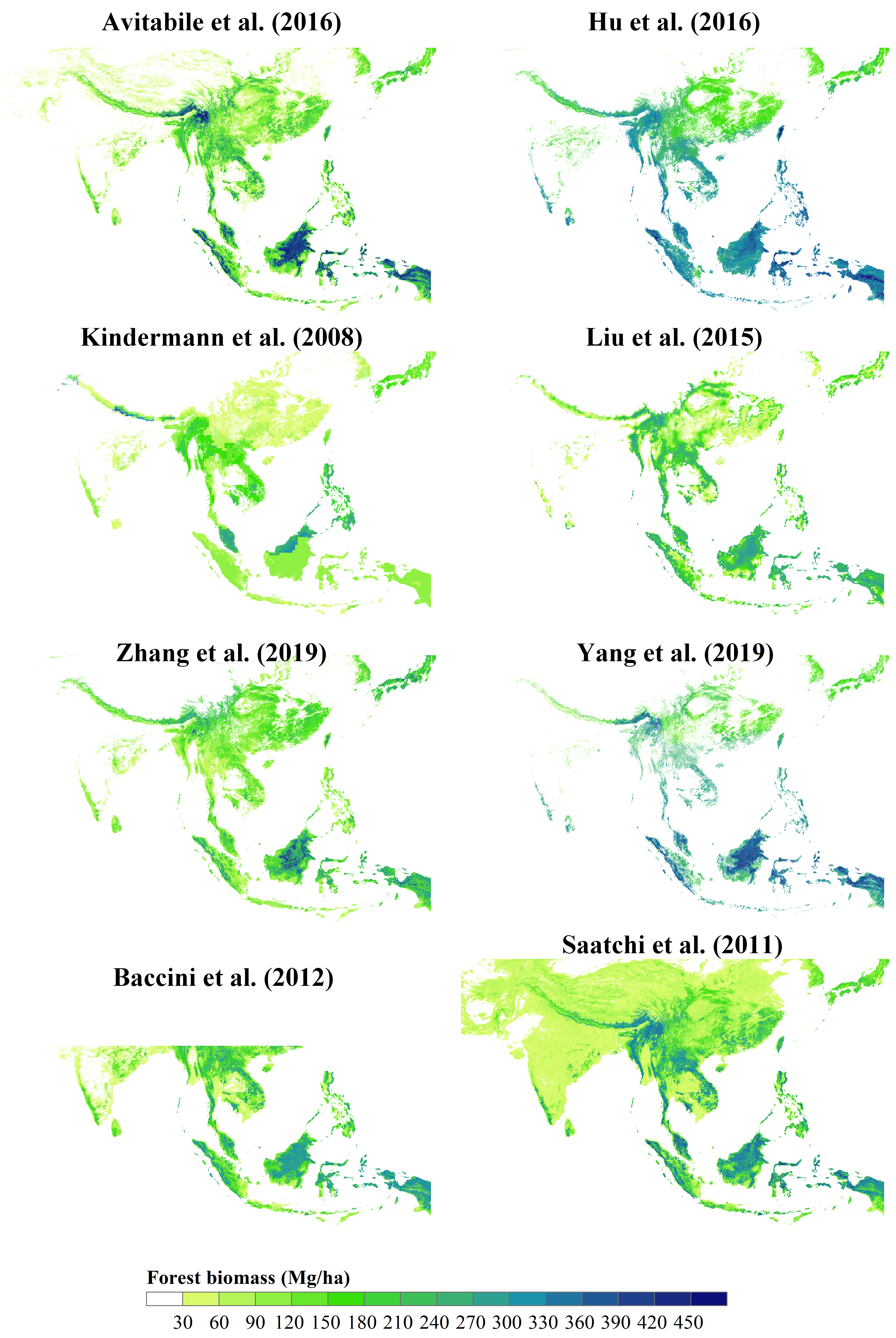
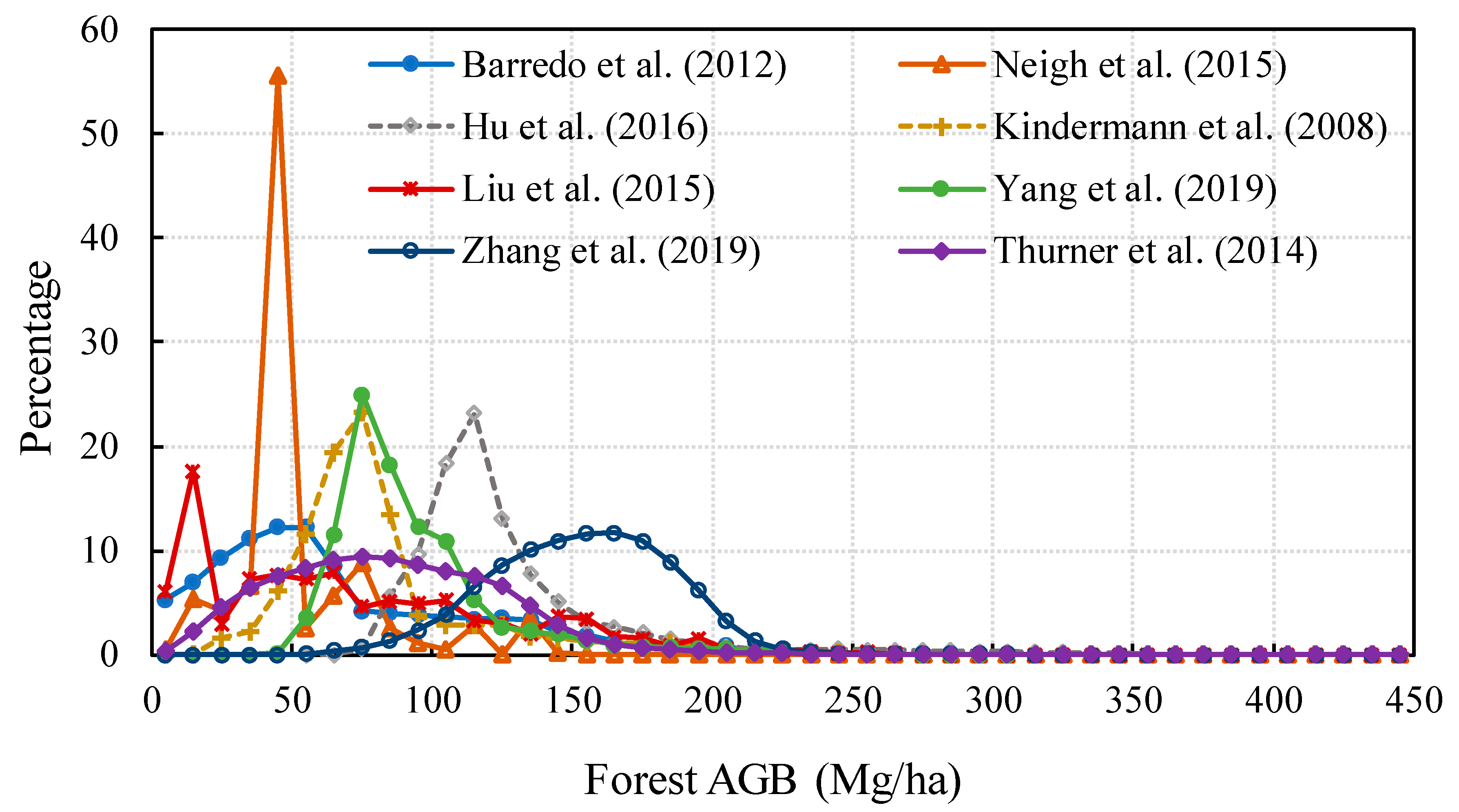
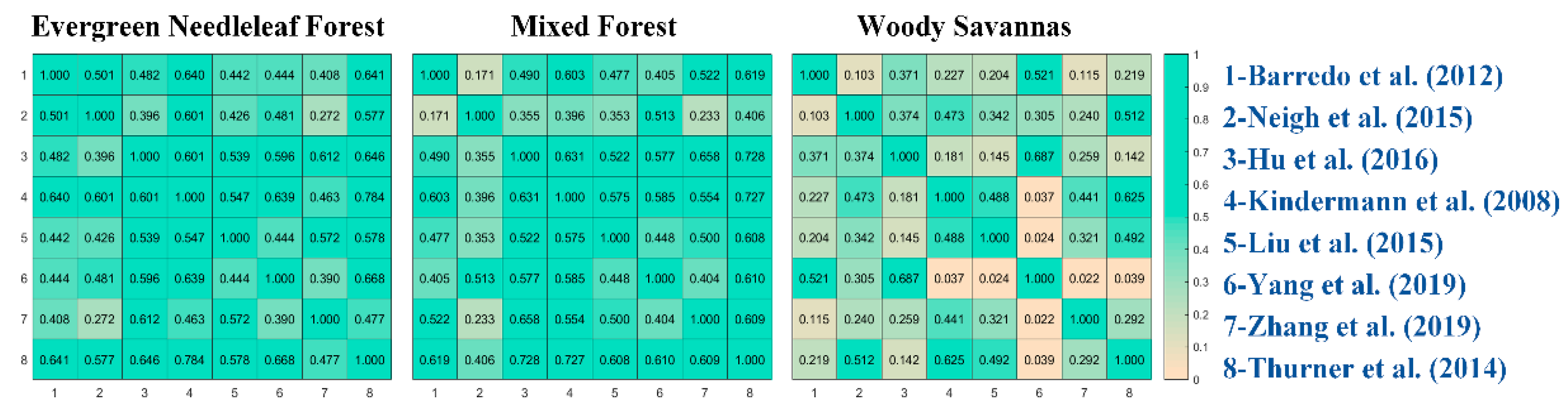
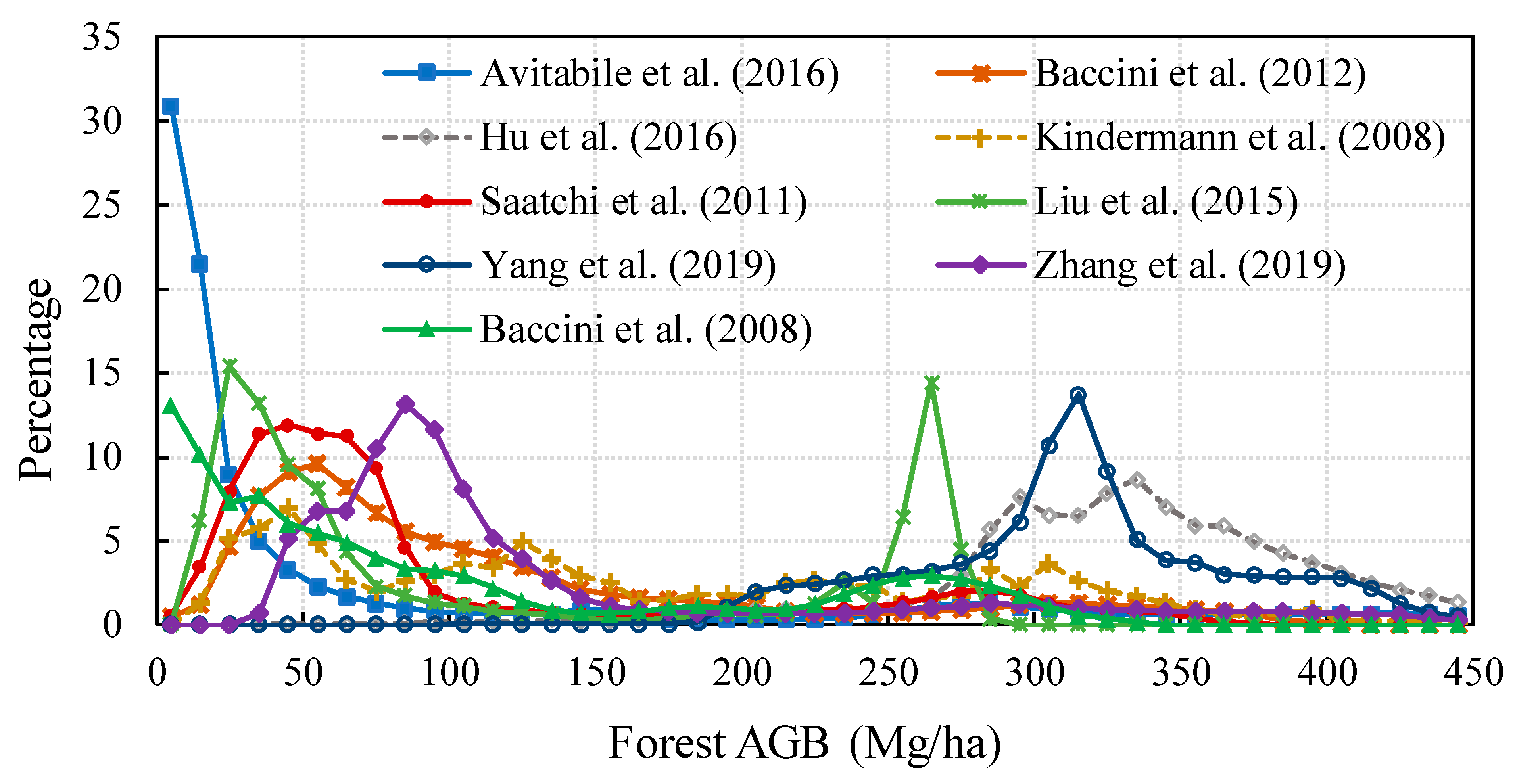
4.1. Europe
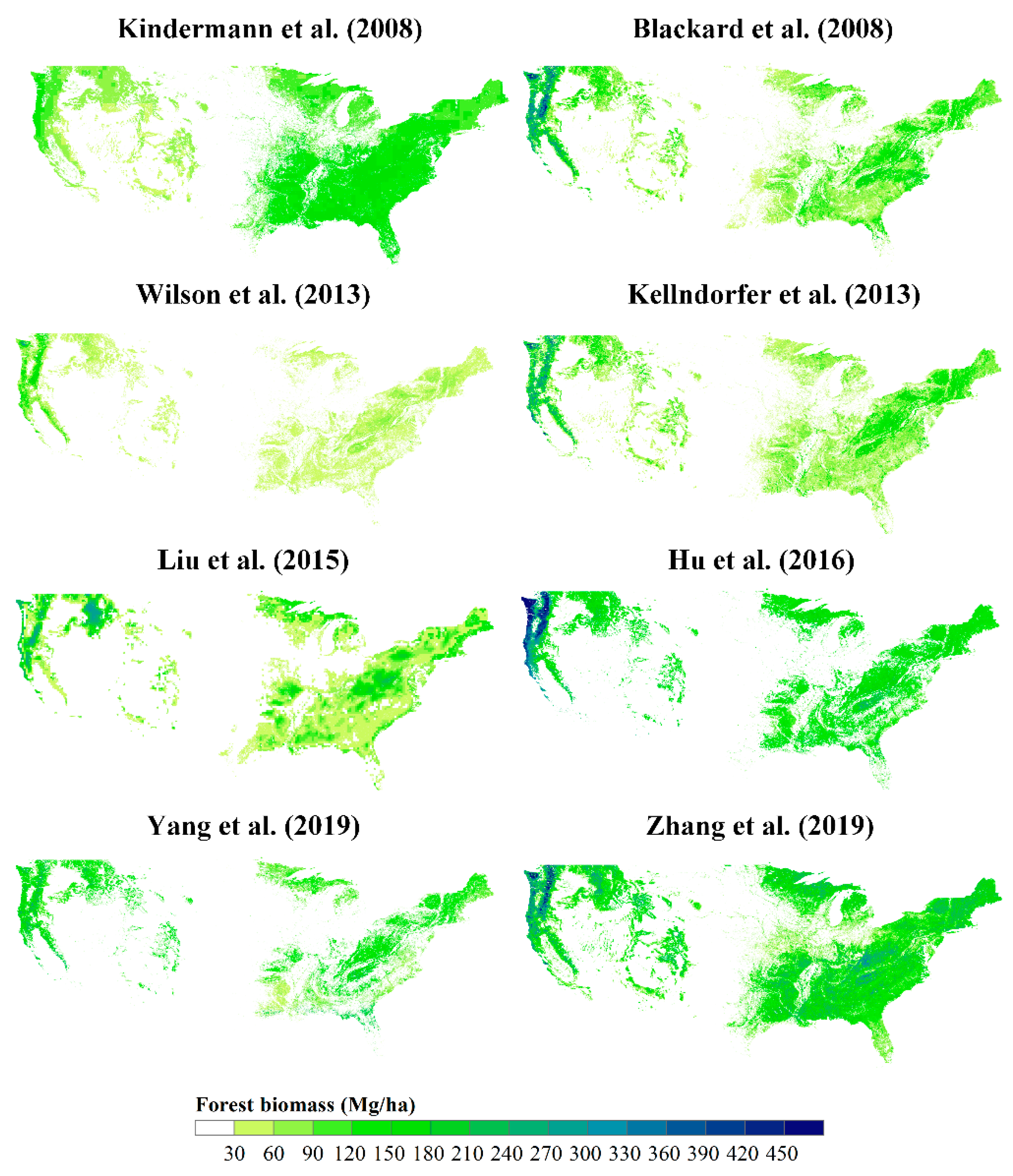
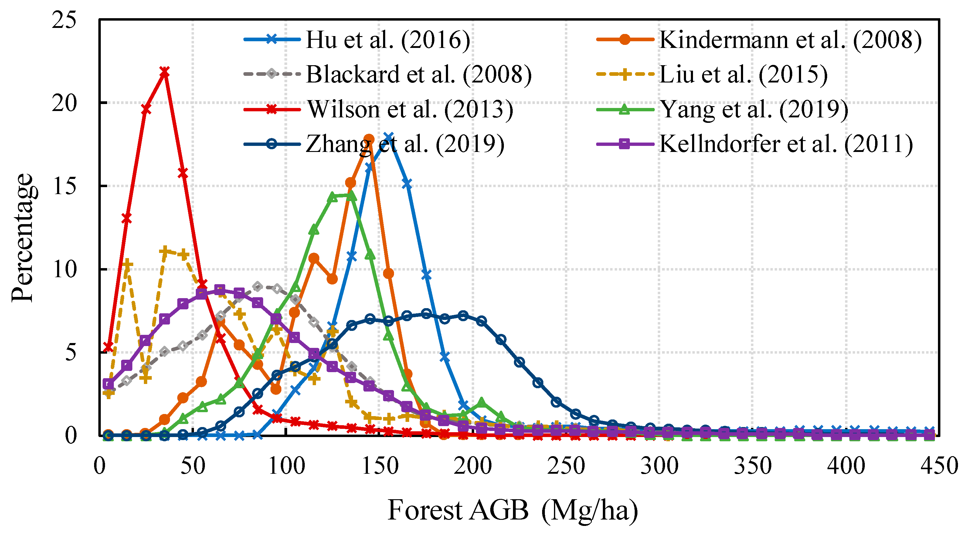
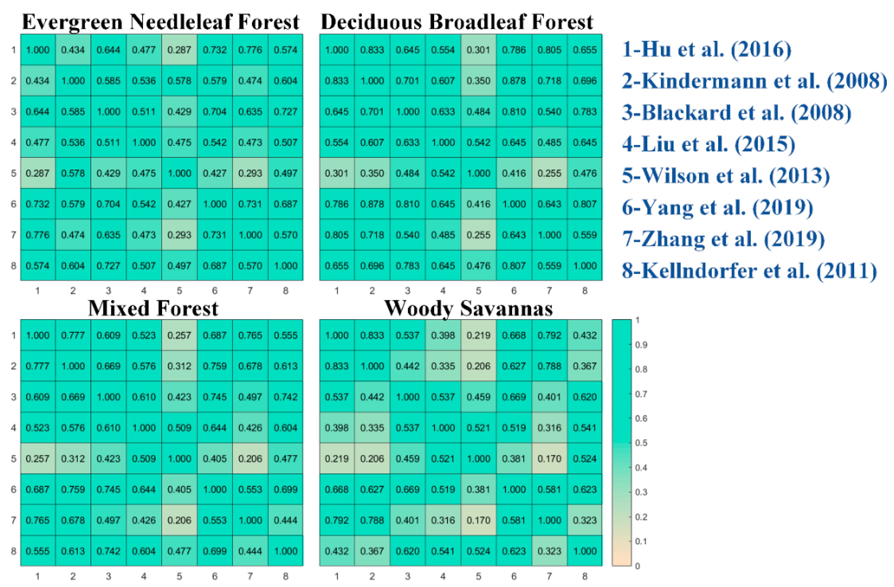
4.2. Conterminous United States
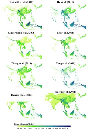
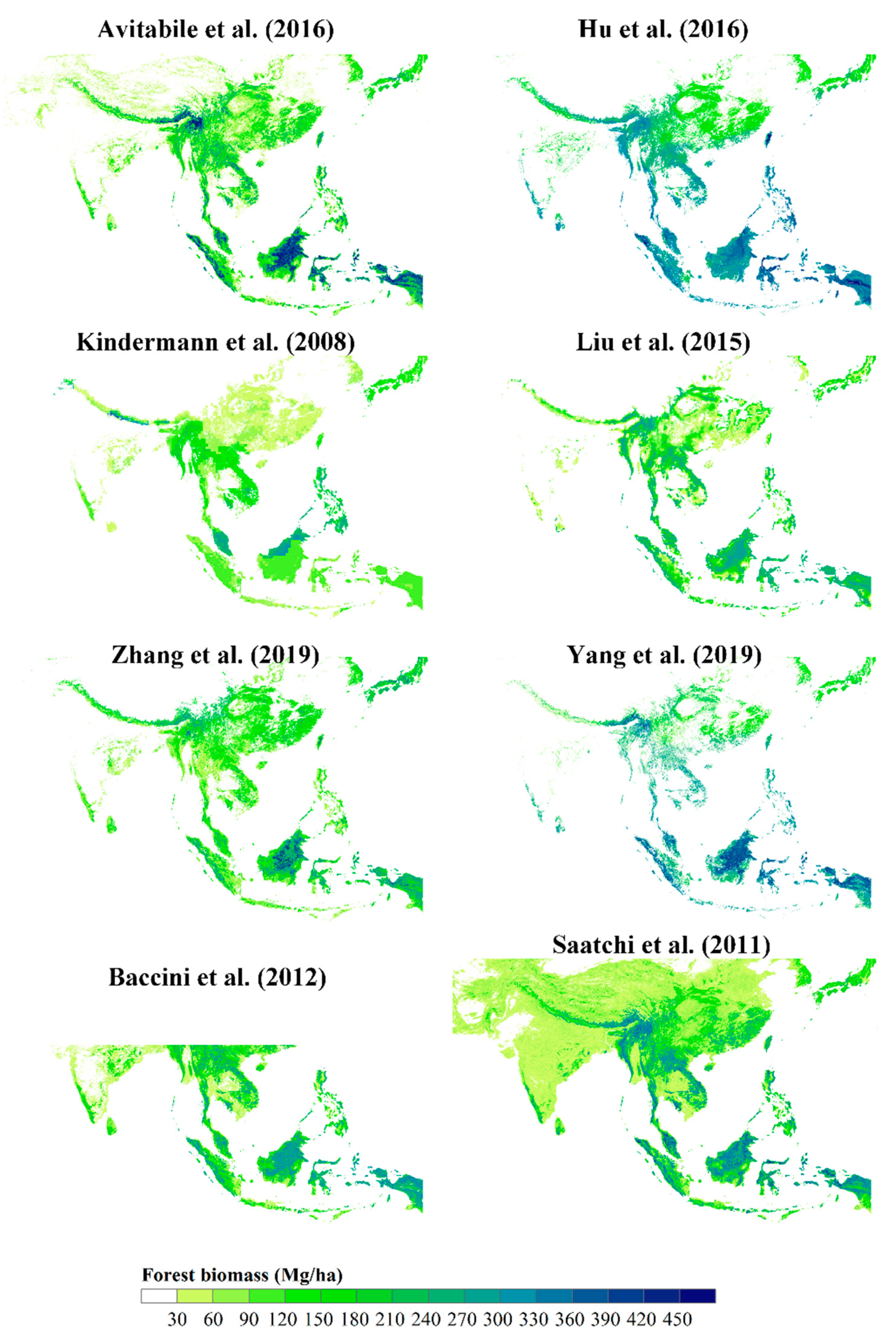
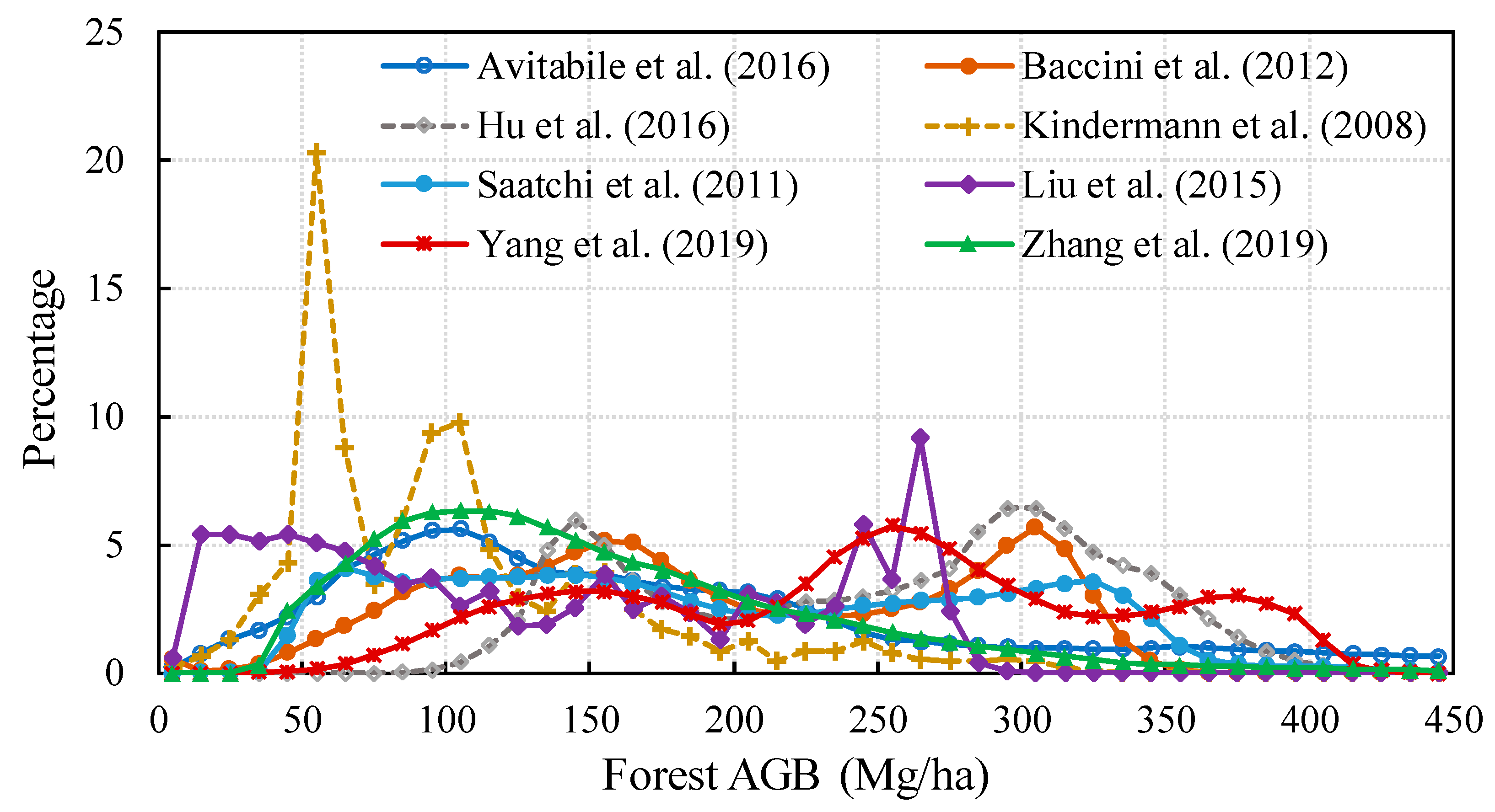
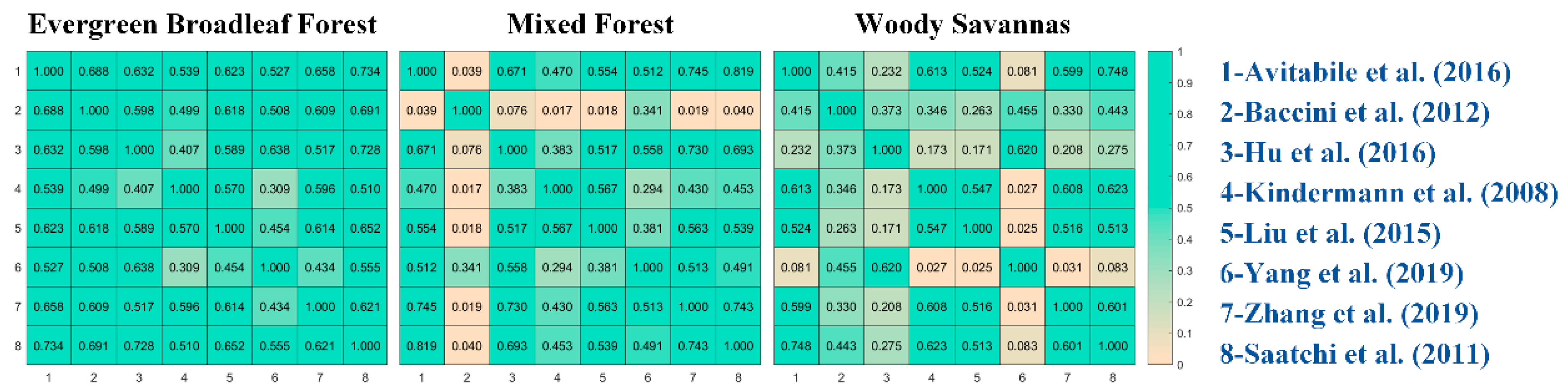
4.3. Southeast Asia
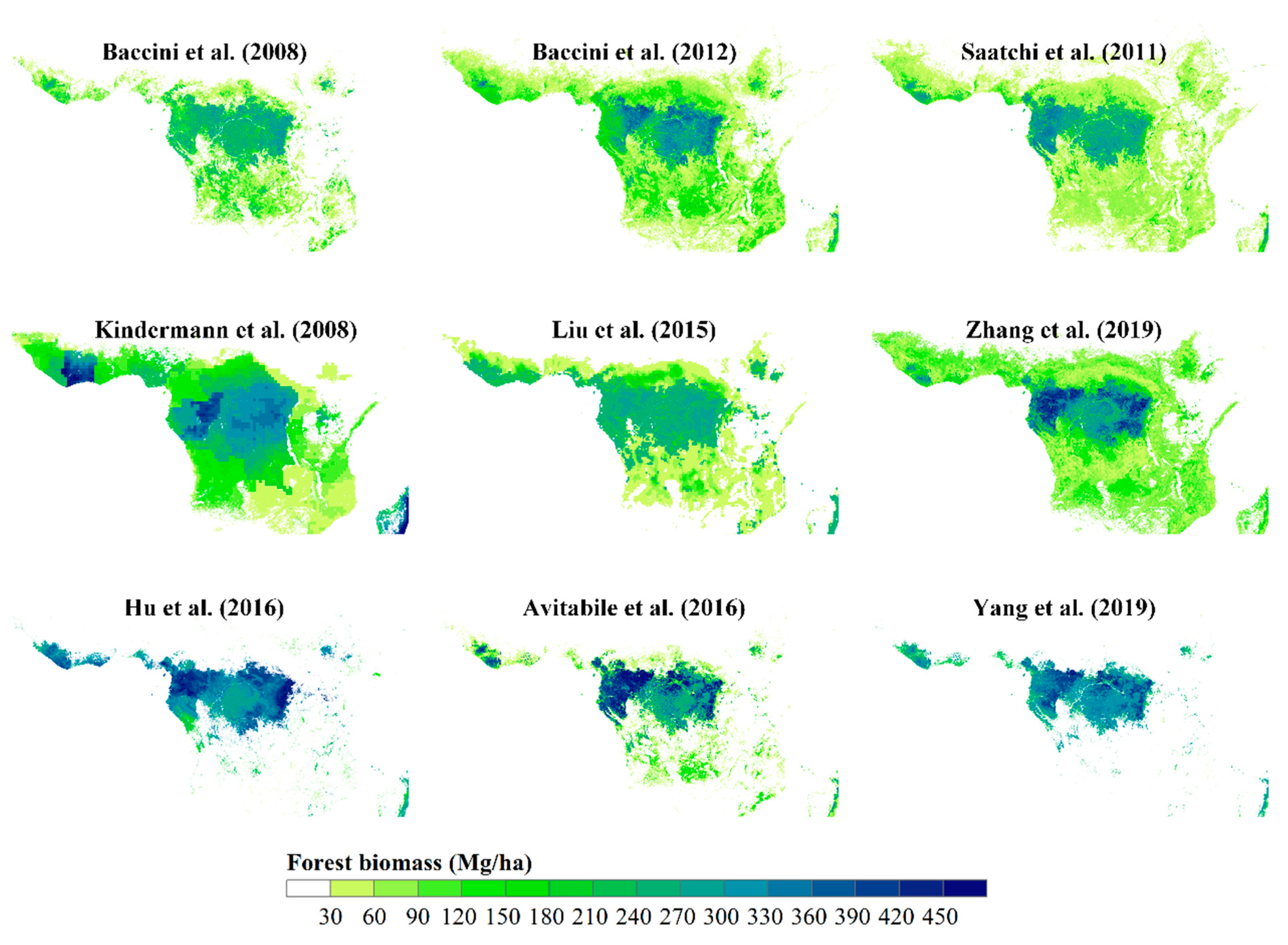
4.4. Tropical Africa
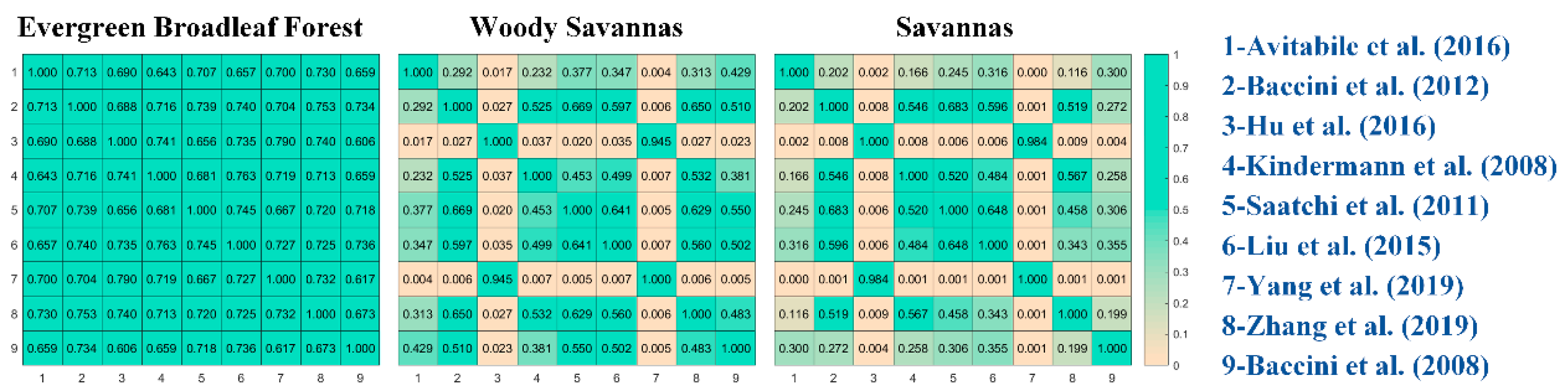
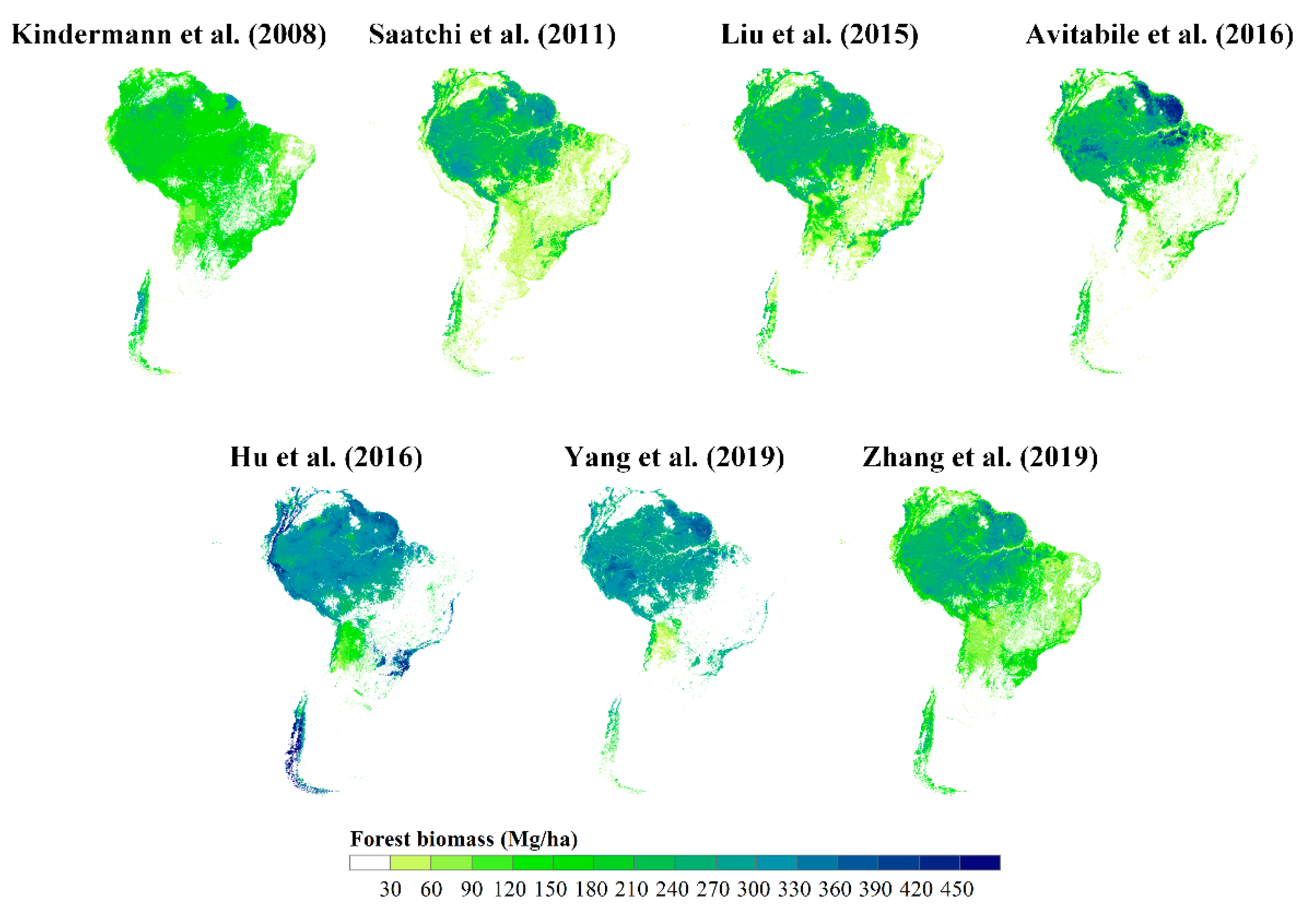
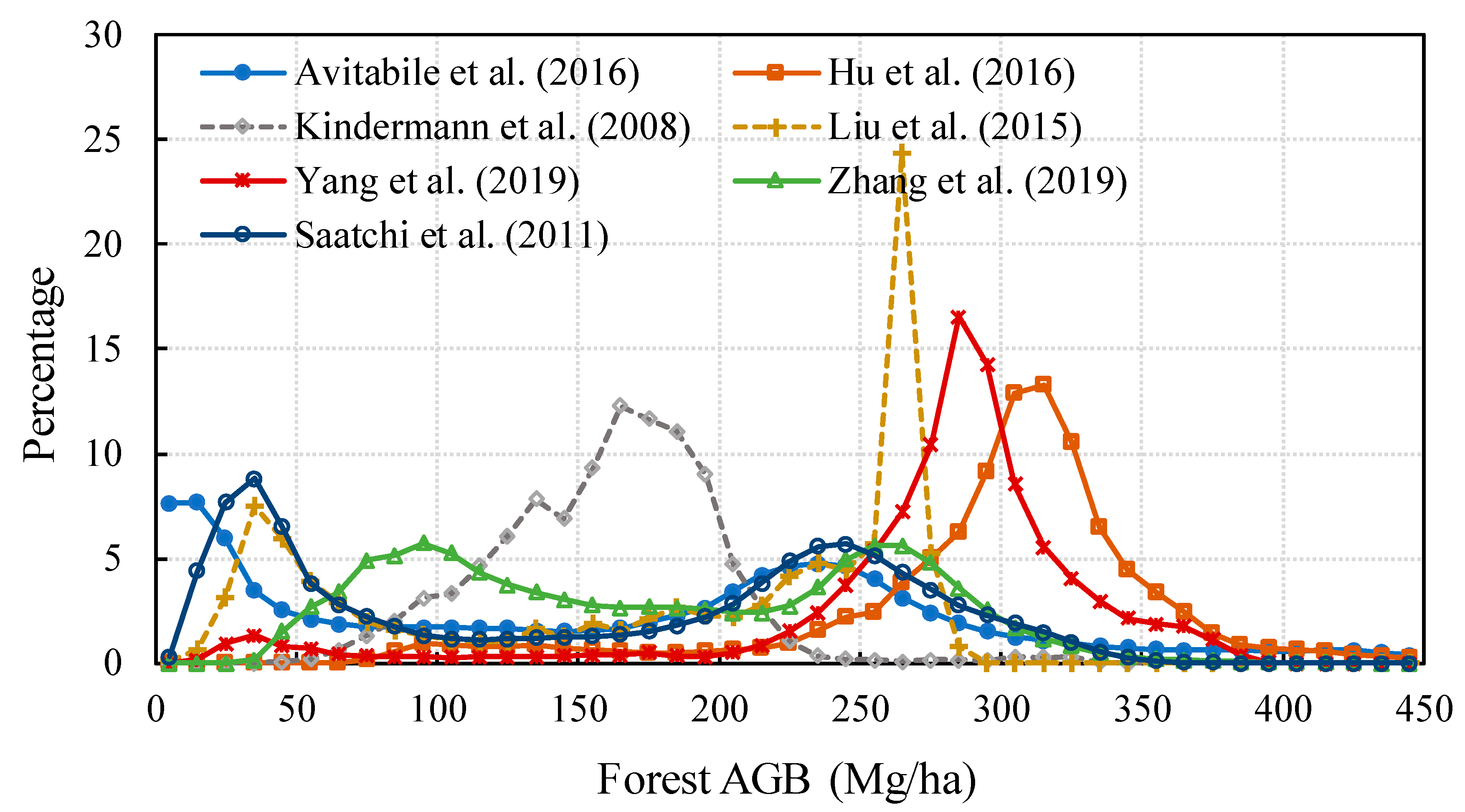
4.5. South America
5. Limitations of Current AGB Maps and Future Improvements
5.1. Compilation of Field Biomass Data
5.2. Data Sources for Forest AGB Mapping
5.3. Novel Approaches to Forest AGB Mapping
5.4. Accuracy Assessment
5.5. Forest Biomass Dynamics
6. Conclusions
Funding
Conflicts of Interest
References
- Canadell, J.G.; Raupach, M.R. Managing forests for climate change mitigation. Science 2008, 320, 1456–1457. [Google Scholar] [CrossRef] [PubMed]
- Luyssaert, S.; Schulze, E.D.; Borner, A.; Knohl, A.; Hessenmoller, D.; Law, B.E.; Ciais, P.; Grace, J. Old-growth forests as global carbon sinks. Nature 2008, 455, 213–215. [Google Scholar] [CrossRef] [PubMed]
- Kumar, L.; Mutanga, O. Remote Sensing of Above-Ground Biomass. Remote Sens. 2017, 9, 935. [Google Scholar] [CrossRef]
- Kim, D.-H.; Kim, J.-H.; Park, J.-H.; Ewane, E.B.; Lee, D.-H. Correlation between above-ground and below-ground biomass of 13-year-old Pinus densiflora S. et Z. planted in a post-fire area in Samcheok. For. Sci. Technol. 2016, 12, 115–124. [Google Scholar]
- Saatchi, S.S.; Houghton, R.A.; Dos Santos Alvalá, R.C.; Soares, J.V.; Yu, Y. Distribution of aboveground live biomass in the Amazon basin. Glob. Chang. Biol. 2007, 13, 816–837. [Google Scholar] [CrossRef]
- Ketterings, Q.M.; Coe, R.; van Noordwijk, M.; Ambagau’, Y.; Palm, C.A. Reducing uncertainty in the use of allometric biomass equations for predicting above-ground tree biomass in mixed secondary forests. For. Ecol. Manag. 2001, 146, 199–209. [Google Scholar] [CrossRef]
- Fang, J.; Chen, A.; Peng, C.; Zhao, S.; Ci, L. Changes in Forest Biomass Carbon Storage in China Between 1949 and 1998. Science 2001, 292, 2320–2322. [Google Scholar] [CrossRef]
- Fang, J.; Guo, Z.; Hu, H.; Kato, T.; Muraoka, H.; Son, Y. Forest biomass carbon sinks in East Asia, with special reference to the relative contributions of forest expansion and forest growth. Glob. Chang. Biol. 2014, 20, 2019–2030. [Google Scholar] [CrossRef]
- Lu, D.; Chen, Q.; Wang, G.; Liu, L.; Li, G.; Moran, E. A survey of remote sensing-based aboveground biomass estimation methods in forest ecosystems. Int. J. Digit. Earth 2016, 9, 63–105. [Google Scholar] [CrossRef]
- Powell, S.L.; Cohen, W.B.; Healey, S.P.; Kennedy, R.E.; Moisen, G.G.; Pierce, K.B.; Ohmann, J.L. Quantification of live aboveground forest biomass dynamics with Landsat time-series and field inventory data: A comparison of empirical modeling approaches. Remote Sens. Environ. 2010, 114, 1053–1068. [Google Scholar] [CrossRef]
- Sinha, S.; Jeganathan, C.; Sharma, L.K.; Nathawat, M.S. A review of radar remote sensing for biomass estimation. Int. J. Environ. Sci. Technol. 2015, 12, 1779–1792. [Google Scholar] [CrossRef]
- Lim, K.; Treitz, P.; Wulder, M.; St-Onge, B.; Flood, M. LiDAR remote sensing of forest structure. Prog. Phys. Geog. 2003, 27, 88–106. [Google Scholar] [CrossRef]
- Tian, X.; Yan, M.; van der Tol, C.; Li, Z.; Su, Z.; Chen, E.; Li, X.; Li, L.; Wang, X.; Pan, X.; et al. Modeling forest above-ground biomass dynamics using multi-source data and incorporated models: A case study over the qilian mountains. Agric. For. Meteorol. 2017, 246, 1–14. [Google Scholar] [CrossRef]
- Hurtt, G.C.; Fisk, J.; Thomas, R.Q.; Dubayah, R.; Moorcroft, P.R.; Shugart, H.H. Linking models and data on vegetation structure. J. Geophys. Res. Biogeosci. 2010, 115, G00E10. [Google Scholar] [CrossRef]
- Waring, R.H.; Coops, N.C.; Landsberg, J.J. Improving predictions of forest growth using the 3-PGS model with observations made by remote sensing. For. Ecol. Manag. 2010, 259, 1722–1729. [Google Scholar] [CrossRef]
- Zolkos, S.G.; Goetz, S.J.; Dubayah, R. A meta-analysis of terrestrial aboveground biomass estimation using lidar remote sensing. Remote Sens. Environ. 2013, 128, 289–298. [Google Scholar] [CrossRef]
- Goetz, S.; Baccini, A.; Laporte, N.; Johns, T.; Walker, W.; Kellndorfer, J.; Houghton, R.; Sun, M. Mapping and monitoring carbon stocks with satellite observations: A comparison of methods. Carbon Balance Manag. 2009, 4, 2. [Google Scholar] [CrossRef]
- Baccini, A.; Goetz, S.J.; Walker, W.S.; Laporte, N.T.; Sun, M.; Sulla-Menashe, D.; Hackler, J.; Beck, P.S.A.; Dubayah, R.; Friedl, M.A.; et al. Estimated carbon dioxide emissions from tropical deforestation improved by carbon-density maps. Nat. Clim. Chang. 2012, 2, 182–185. [Google Scholar] [CrossRef]
- Saatchi, S.S.; Harris, N.L.; Brown, S.; Lefsky, M.; Mitchard, E.T.A.; Salas, W.; Zutta, B.R.; Buermann, W.; Lewis, S.L.; Hagen, S.; et al. Benchmark map of forest carbon stocks in tropical regions across three continents. Proc. Natl. Acad. Sci. USA 2011, 108, 9899–9904. [Google Scholar] [CrossRef]
- Carvalhais, N.; Forkel, M.; Khomik, M.; Bellarby, J.; Jung, M.; Migliavacca, M.; Mu, M.; Saatchi, S.; Santoro, M.; Thurner, M.; et al. Global covariation of carbon turnover times with climate in terrestrial ecosystems. Nature 2014, 514, 213–217. [Google Scholar] [CrossRef]
- Langner, A.; Achard, F.; Grassi, G. Can recent pan-tropical biomass maps be used to derive alternative Tier 1 values for reporting REDD+ activities under UNFCCC? Environ. Res. Lett. 2014, 9, 124008. [Google Scholar] [CrossRef]
- Zhang, Y.; Liang, S. Surface radiative forcing of forest disturbances over northeastern China. Environ. Res. Lett. 2014, 9, 024002. [Google Scholar] [CrossRef]
- Zhang, Y.; Liang, S. Changes in forest biomass and linkage to climate and forest disturbances over Northeastern China. Glob. Chang. Biol. 2014, 20, 2596–2606. [Google Scholar] [CrossRef] [PubMed]
- Lu, D. The potential and challenge of remote sensing-based biomass estimation. Int. J. Remote Sens. 2006, 27, 1297–1328. [Google Scholar] [CrossRef]
- Koch, B. Status and future of laser scanning, synthetic aperture radar and hyperspectral remote sensing data for forest biomass assessment. ISPRS J. Photogramm. 2010, 65, 581–590. [Google Scholar] [CrossRef]
- Lucas, R.M.; Mitchell, A.L.; Armston, J. Measurement of Forest Above-Ground Biomass Using Active and Passive Remote Sensing at Large (Subnational to Global) Scales. Curr. For. Rep. 2015, 1, 162–177. [Google Scholar] [CrossRef]
- Chave, J.; Andalo, C.; Brown, S.; Cairns, M.A.; Chambers, J.Q.; Eamus, D.; Fölster, H.; Fromard, F.; Higuchi, N.; Kira, T. Tree allometry and improved estimation of carbon stocks and balance in tropical forests. Oecologia 2005, 145, 87–99. [Google Scholar] [CrossRef]
- Wu, X.; Wang, X.; Wu, Y.; Xia, X.; Fang, J. Forest biomass is strongly shaped by forest height across boreal to tropical forests in China. J. Plant Ecol. 2015, 8, 559–567. [Google Scholar] [CrossRef]
- Solberg, S.; Næsset, E.; Gobakken, T.; Bollandsås, O.-M. Forest biomass change estimated from height change in interferometric SAR height models. Carbon Balance Manag. 2014, 9, 5. [Google Scholar] [CrossRef]
- Yu, Y.; Saatchi, S.; Heath, L.S.; LaPoint, E.; Myneni, R.; Knyazikhin, Y. Regional distribution of forest height and biomass from multisensor data fusion. J. Geophys. Res. Biogeosci. 2010, 115, G00E12. [Google Scholar] [CrossRef]
- Palace, M.W.; Sullivan, F.B.; Ducey, M.J.; Treuhaft, R.N.; Herrick, C.; Shimbo, J.Z.; Mota-E-Silva, J. Estimating forest structure in a tropical forest using field measurements, a synthetic model and discrete return lidar data. Remote Sens. Environ. 2015, 161, 1–11. [Google Scholar] [CrossRef]
- Zhang, G.; Ganguly, S.; Nemani, R.R.; White, M.A.; Milesi, C.; Hashimoto, H.; Wang, W.; Saatchi, S.; Yu, Y.; Myneni, R.B. Estimation of forest aboveground biomass in California using canopy height and leaf area index estimated from satellite data. Remote Sens. Environ. 2014, 151, 44–56. [Google Scholar] [CrossRef]
- Zhang, X.; Kondragunta, S. Estimating forest biomass in the USA using generalized allometric models and MODIS land products. Geophys. Res. Lett. 2006, 33, L09402. [Google Scholar] [CrossRef]
- Berner, L.T.; Law, B.E. Plant traits, productivity, biomass and soil properties from forest sites in the Pacific Northwest, 1999–2014. Sci. Data 2016, 3, 160002. [Google Scholar] [CrossRef]
- Zhang, H.; Wang, K.; Xu, X.; Song, T.; Xu, Y.; Zeng, F. Biogeographical patterns of biomass allocation in leaves, stems, and roots in China’s forests. Sci. Rep. 2015, 5, 15997. [Google Scholar] [CrossRef]
- Keeling, H.C.; Phillips, O.L. The global relationship between forest productivity and biomass. Glob. Ecol. Biogeogr. 2007, 16, 618–631. [Google Scholar] [CrossRef]
- Ernest, S.K.M.; Enquist, B.J.; Brown, J.H.; Charnov, E.L.; Gillooly, J.F.; Savage, V.M.; White, E.P.; Smith, F.A.; Hadly, E.A.; Haskell, J.P.; et al. Thermodynamic and metabolic effects on the scaling of production and population energy use. Ecol. Lett. 2003, 6, 990–995. [Google Scholar] [CrossRef]
- Hui, D.; Wang, J.; Le, X.; Shen, W.; Ren, H. Influences of biotic and abiotic factors on the relationship between tree productivity and biomass in China. For. Ecol. Manag. 2012, 264, 72–80. [Google Scholar] [CrossRef]
- Tian, F.; Brandt, M.; Liu, Y.Y.; Verger, A.; Tagesson, T.; Diouf, A.A.; Rasmussen, K.; Mbow, C.; Wang, Y.; Fensholt, R. Remote sensing of vegetation dynamics in drylands: Evaluating vegetation optical depth (VOD) using AVHRR NDVI and in situ green biomass data over West African Sahel. Remote Sens. Environ. 2016, 177, 265–276. [Google Scholar] [CrossRef]
- Garroutte, E.L.; Hansen, A.J.; Lawrence, R.L. Using NDVI and EVI to Map Spatiotemporal Variation in the Biomass and Quality of Forage for Migratory Elk in the Greater Yellowstone Ecosystem. Remote Sens. 2016, 8, 404. [Google Scholar] [CrossRef]
- Durante, P.; Martín-Alcón, S.; Gil-Tena, A.; Algeet, N.; Tomé, J.L.; Recuero, L.; Palacios-Orueta, A.; Oyonarte, C. Improving Aboveground Forest Biomass Maps: From High-Resolution to National Scale. Remote Sens. 2019, 11, 795. [Google Scholar] [CrossRef]
- Chen, J.M. Evaluation of Vegetation Indices and a Modified Simple Ratio for Boreal Applications. Can. J. Remote Sens. 1996, 22, 229–242. [Google Scholar] [CrossRef]
- Liu, Y.Y.; van Dijk, A.I.J.M.; McCabe, M.F.; Evans, J.P.; de Jeu, R.A.M. Global vegetation biomass change (1988–2008) and attribution to environmental and human drivers. Glob. Ecol. Biogeogr. 2013, 22, 692–705. [Google Scholar] [CrossRef]
- Blackard, J.A.; Finco, M.V.; Helmer, E.H.; Holden, G.R.; Hoppus, M.L.; Jacobs, D.M.; Lister, A.J.; Moisen, G.G.; Nelson, M.D.; Riemann, R.; et al. Mapping, U.S. forest biomass using nationwide forest inventory data and moderate resolution information. Remote Sens. Environ. 2008, 112, 1658–1677. [Google Scholar] [CrossRef]
- Hansen, M.C.; Potapov, P.V.; Moore, R.; Hancher, M.; Turubanova, S.A.; Tyukavina, A.; Thau, D.; Stehman, S.V.; Goetz, S.J.; Loveland, T.R.; et al. High-Resolution Global Maps of 21st-Century Forest Cover Change. Science 2013, 342, 850–853. [Google Scholar] [CrossRef] [PubMed]
- McEwan, R.W.; Lin, Y.-C.; Sun, I.F.; Hsieh, C.-F.; Su, S.-H.; Chang, L.-W.; Song, G.-Z.M.; Wang, H.-H.; Hwong, J.-L.; Lin, K.-C.; et al. Topographic and biotic regulation of aboveground carbon storage in subtropical broad-leaved forests of Taiwan. For. Ecol. Manag. 2011, 262, 1817–1825. [Google Scholar] [CrossRef]
- Frolking, S.; Palace, M.W.; Clark, D.B.; Chambers, J.Q.; Shugart, H.H.; Hurtt, G.C. Forest disturbance and recovery: A general review in the context of spaceborne remote sensing of impacts on aboveground biomass and canopy structure. J. Geophys. Res. Biogeosci. 2009, 114, G00E02. [Google Scholar] [CrossRef]
- Asner, G.P.; Flint Hughes, R.; Varga, T.A.; Knapp, D.E.; Kennedy-Bowdoin, T. Environmental and Biotic Controls over Aboveground Biomass Throughout a Tropical Rain Forest. Ecosystems 2009, 12, 261–278. [Google Scholar] [CrossRef]
- Ruesch, A.S.; Gibbs, H.K. New IPCC Tier-1 Global Biomass Carbon Map For the Year 2000. Carbon Dioxide Information Analysis Center, 2008. Available online: http://cdiac.ornl.gov (accessed on 13 September 2017).
- IPCC. 2006 IPCC Guidelines for National Greenhouse Gas Inventories; Institute for Global Environmental Strategies: Hayama, Japan, 2006. [Google Scholar]
- Barredo, J.I.; San-Miguel-Ayanz, J.; Caudullo, G.; Busetto, L. A European Map of Living Forest Biomass and Carbon Stock; EUR–Scientific and Technical Research; Joint Research Centre of the European Commission: Ispra, Italy, 2012; p. 25730. [Google Scholar]
- FAO. Global Forest Resources Assessment 2010: Main Report; Food and Agriculture Organization of the United Nations: Rome, Italy, 2010. [Google Scholar]
- Hengeveld, G.M.; Gunia, K.; Didion, M.; Zudin, S.; Clerkx, A.P.P.M.; Schelhaas, M.J. Global 1-degree Maps of Forest Area, Carbon Stocks, and Biomass, 1950-2010; ORNL DAAC: Oak Ridge, TN, USA, 2015. [CrossRef]
- Kindermann, G.E.; McCallum, I.; Fritz, S.; Obersteiner, M. A global forest growing stock, biomass and carbon map based on FAO statistics. Silva Fenn. 2008, 42, 387–396. [Google Scholar] [CrossRef]
- Brown, S.; Gaston, G. Tropical Africa: Land Use, Biomass, and Carbon Estimates for 1980: NDP-055; Carbon Dioxide Information Center, Oak Ridge National Laboratory: Oak Rigde, TN, USA, 2001; revised for the web 2001.
- Brown, S.L.; Iverson, L.R.; Prasad, A.M.; Beaty, T.W. Geographical Distribution of Biomass Carbon in Tropical Southeast Asian Forests: A Database; Carbon Dioxide Information Center, Environmental Sciences Division, Oak Ridge National Laboratory: Oak Ridge, TN, USA, 2001.
- Gibbs, H.; Brown, S. Geographical Distribution of Woody Biomass Carbon Stocks in Tropical Africa: An Updated Database for 2000; Carbon Dioxide Information Center, Oak Ridge National Laboratory: Oak Ridge, TN, USA, 2007. Available online: http://cdiac.ornl.gov/epubs/ndp/ndp055/ndp055b.html (accessed on 19 November 2014).
- Gibbs, H.K.; Brown, S. Geographical Distribution of Biomass Carbon in Tropical Southeast Asian Forests: An Updated Database for 2000; Carbon Dioxide Information Center, Oak Ridge National Laboratory: Oak Ridge, TN, USA, 2007. Available online: http://cdiac.ornl.gov/epubs/ndp/ndp068/ndp068b.html (accessed on 19 November 2014).
- Kellndorfer, J.; Walker, W.; Kirsch, K.; Fiske, G.; Bishop, J.; LaPoint, L.; Hoppus, M.; Westfall, J. NACP Aboveground Biomass and Carbon Baseline Data, V. 2 (NBCD 2000); ORNL DAAC: Oak Ridge, TN, USA, 2013. [CrossRef]
- Hardiman, B.S.; Wang, J.A.; Hutyra, L.R.; Gately, C.K.; Getson, J.M.; Friedl, M.A. Accounting for urban biogenic fluxes in regional carbon budgets. Sci. Total Environ. 2017, 592, 366–372. [Google Scholar] [CrossRef]
- Raciti, S.M.; Hutyra, L.R.; Newell, J.D. Mapping carbon storage in urban trees with multi-source remote sensing data: Relationships between biomass, land use, and demographics in Boston neighborhoods. Sci. Total Environ. 2014, 500, 72–83. [Google Scholar] [CrossRef] [PubMed]
- Rodriguez-Veiga, P.; Quegan, S.; Carreiras, J.; Persson, H.J.; Fransson, J.E.S.; Hoscilo, A.; Ziolkowski, D.; Sterenczak, K.; Lohberger, S.; Staengel, M.; et al. Forest biomass retrieval approaches from earth observation in different biomes. Int. J. Appl. Earth Obs. 2019, 77, 53–68. [Google Scholar] [CrossRef]
- Wilson, B.T.; Woodall, C.; Griffith, D. Imputing forest carbon stock estimates from inventory plots to a nationally continuous coverage. Carbon Balance Manag. 2013, 8, 1. [Google Scholar] [CrossRef]
- Ji, L.; Wylie, B.K.; Nossov, D.R.; Peterson, B.; Waldrop, M.P.; McFarland, J.W.; Rover, J.; Hollingsworth, T.N. Estimating aboveground biomass in interior Alaska with Landsat data and field measurements. Int. J. Appl. Earth Obs. 2012, 18, 451–461. [Google Scholar] [CrossRef]
- Cartus, O.; Kellndorfer, J.; Walker, W.; Franco, C.; Bishop, J.; Santos, L.; Fuentes, J. A National, Detailed Map of Forest Aboveground Carbon Stocks in Mexico. Remote Sens. 2014, 6, 5559–5588. [Google Scholar] [CrossRef]
- Rodríguez-Veiga, P.; Saatchi, S.; Tansey, K.; Balzter, H. Magnitude, spatial distribution and uncertainty of forest biomass stocks in Mexico. Remote Sens. Environ. 2016, 183, 265–281. [Google Scholar] [CrossRef]
- Le Toan, T.; Quegan, S.; Davidson, M.W.J.; Balzter, H.; Paillou, P.; Papathanassiou, K.; Plummer, S.; Rocca, F.; Saatchi, S.; Shugart, H.; et al. The BIOMASS mission: Mapping global forest biomass to better understand the terrestrial carbon cycle. Remote Sens. Environ. 2011, 115, 2850–2860. [Google Scholar] [CrossRef]
- Beaudoin, A.; Bernier, P.Y.; Guindon, L.; Villemaire, P.; Guo, X.J.; Stinson, G.; Bergeron, T.; Magnussen, S.; Hall, R.J. Mapping attributes of Canada’s forests at moderate resolution through kNN and MODIS imagery. Can. J. For. Res. 2014, 44, 521–532. [Google Scholar] [CrossRef]
- Beaudoin, A.; Bernier, P.Y.; Villemaire, P.; Guindon, L.; Guo, X.J. Tracking forest attributes across Canada between 2001 and 2011 using a k nearest neighbors mapping approach applied to MODIS imagery. Can. J. For. Res. 2017, 48, 85–93. [Google Scholar] [CrossRef]
- Gallaun, H.; Zanchi, G.; Nabuurs, G.-J.; Hengeveld, G.; Schardt, M.; Verkerk, P.J. EU-wide maps of growing stock and above-ground biomass in forests based on remote sensing and field measurements. For. Ecol. Manag. 2010, 260, 252–261. [Google Scholar] [CrossRef]
- Houghton, R.A.; Butman, D.; Bunn, A.G.; Krankina, O.N.; Schlesinger, P.; Stone, T.A. Mapping Russian forest biomass with data from satellites and forest inventories. Environ. Res. Lett. 2007, 2, 045032. [Google Scholar] [CrossRef]
- Yin, G.; Zhang, Y.; Sun, Y.; Wang, T.; Zeng, Z.; Piao, S. MODIS Based Estimation of Forest Aboveground Biomass in China. PLoS ONE 2015, 10, e0130143. [Google Scholar] [CrossRef]
- Du, L.; Zhou, T.; Zou, Z.; Zhao, X.; Huang, K.; Wu, H. Mapping Forest Biomass Using Remote Sensing and National Forest Inventory in China. Forests 2014, 5, 1267–1283. [Google Scholar] [CrossRef]
- Saatchi, S.; Malhi, Y.; Zutta, B.; Buermann, W.; Anderson, L.O.; Araujo, A.M.; Phillips, O.L.; Peacock, J.; ter Steege, H.; Lopez Gonzalez, G.; et al. Mapping landscape scale variations of forest structure, biomass, and productivity in Amazonia. Biogeosci. Discuss. 2009, 6, 5461–5505. [Google Scholar] [CrossRef]
- Avtar, R.; Suzuki, R.; Takeuchi, W.; Sawada, H. PALSAR 50 m Mosaic Data Based National Level Biomass Estimation in Cambodia for Implementation of REDD+ Mechanism. PLoS ONE 2013, 8, e74807. [Google Scholar] [CrossRef] [PubMed]
- Anaya, J.A.; Chuvieco, E.; Palacios-Orueta, A. Aboveground biomass assessment in Colombia: A remote sensing approach. For. Ecol. Manag. 2009, 257, 1237–1246. [Google Scholar] [CrossRef]
- Zhang, Y.; Liang, S. A new high-resolution global forest above-ground biomass map in 2000s by integrating comprehensive reference datasets with multiple high-level satellite products. Int. J. Appl. Earth Obs. 2019. submitted. [Google Scholar]
- Cook, B.D.; Swatantran, A.; Duncanson, L.; Armstrong, A.; Pinto, N.; Nelson, R.F. CMS: LiDAR-derived Estimates of Aboveground Biomass at Four Forested Sites, USA; ORNL Distributed Active Archive Center: Oak Ridge, TN, USA, 2014. [CrossRef]
- Babcock, C.; Finley, A.O.; Cook, B.D.; Weiskittel, A.; Woodall, C.W. CMS: Aboveground Biomass from Penobscot Experimental Forest, Maine, 2012; ORNL Distributed Active Archive Center: Oak Ridge, TN, USA, 2016. [CrossRef]
- Babcock, C.; Finley, A.O.; Cook, B.D.; Weiskittel, A.; Woodall, C.W. Modeling forest biomass and growth: Coupling long-term inventory and LiDAR data. Remote Sens. Environ. 2016, 182, 1–12. [Google Scholar] [CrossRef]
- Dubayah, R.O.; Swatantran, A.; Huang, W.; Duncanson, L.; Johnson, K.; Tang, H.; Dunne, J.O.; Hurtt, G.C. CMS: LiDAR-derived Aboveground Biomass, Canopy Height and Cover for Maryland, 2011; ORNL Distributed Active Archive Center: Oak Ridge, TN, USA, 2016. [CrossRef]
- Dubayah, R.O.; Swatantran, A.; Huang, W.; Duncanson, L.; Tang, H.; Johnson, K.; Dunne, J.O.; Hurtt, G.C. CMS: LiDAR-derived Biomass, Canopy Height and Cover, Sonoma County, California, 2013; ORNL Distributed Active Archive Center: Oak Ridge, TN, USA, 2017. [CrossRef]
- Xu, Q.; Man, A.; Fredrickson, M.; Hou, Z.; Pitkänen, J.; Wing, B.; Ramirez, C.; Li, B.; Greenberg, J.A. Quantification of uncertainty in aboveground biomass estimates derived from small-footprint airborne LiDAR. Remote Sens. Environ. 2018, 216, 514–528. [Google Scholar] [CrossRef]
- Xu, Q.; Greenberg, J. LiDAR-Derived Aboveground Biomass and Uncertainty for California Forests, 2005–2014; ORNL Distributed Active Archive Center: Oak Ridge, TN, USA, 2018. [CrossRef]
- Neigh, C.S.; Nelson, R.F.; Ranson, K.J.; Margolis, H.; Montesano, P.M.; Sun, G.; Kharuk, V.; Naesset, E.; Wulder, M.A.; Anderson, H. LiDAR-based Biomass Estimates, Boreal Forest Biome, Eurasia, 2005–2006; ORNL DAAC: Oak Ridge, TN, USA, 2015.
- Neigh, C.S.R.; Nelson, R.F.; Ranson, K.J.; Margolis, H.A.; Montesano, P.M.; Sun, G.; Kharuk, V.; Næsset, E.; Wulder, M.A.; Andersen, H.-E. Taking stock of circumboreal forest carbon with ground measurements, airborne and spaceborne LiDAR. Remote Sens. Environ. 2013, 137, 274–287. [Google Scholar] [CrossRef]
- Ståhl, G.; Holm, S.; Gregoire, T.G.; Gobakken, T.; Næsset, E.; Nelson, R. Model-based inference for biomass estimation in a LiDAR sample survey in Hedmark County, Norway. Can. J. For. Res. 2011, 41, 96–107. [Google Scholar] [CrossRef]
- Margolis, H.; Sun, G.; Montesano, P.M.; Nelson, R.F. NACP LiDAR-based Biomass Estimates, Boreal Forest Biome, North America, 2005-2006; ORNL Distributed Active Archive Center: Oak Ridge, TN, USA, 2015.
- Baccini, A.; Laporte, N.; Goetz, S.J.; Sun, M.; Dong, H. A first map of tropical Africa’s above-ground biomass derived from satellite imagery. Environ. Res. Lett. 2008, 3, 045011. [Google Scholar] [CrossRef]
- Mitchard, E.T.A.; Saatchi, S.S.; Lewis, S.L.; Feldpausch, T.R.; Gerard, F.F.; Woodhouse, I.H.; Meir, P. Comment on A first map of tropical Africa’s above-ground biomass derived from satellite imagery. Environ. Res. Lett. 2011, 6, 49001–49006. [Google Scholar] [CrossRef]
- Baccini, A.; Walker, W.; Farina, M.; Houghton, R.A. CMS: Estimated Deforested Area Biomass, Tropical America, Africa, and Asia, 2000; ORNL Distributed Active Archive Center: Oak Ridge, TN, USA, 2016. [CrossRef]
- Asner, G.P.; Mascaro, J.; Anderson, C.; Knapp, D.E.; Martin, R.E.; Kennedy-Bowdoin, T.; van Breugel, M.; Davies, S.; Hall, J.S.; Muller-Landau, H.C.; et al. High-fidelity national carbon mapping for resource management and REDD+. Carbon Balance Manag. 2013, 8, 7. [Google Scholar] [CrossRef]
- Asner, G.P.; Knapp, D.E.; Martin, R.E.; Tupayachi, R.; Anderson, C.B.; Mascaro, J.; Sinca, F.; Chadwick, K.D.; Higgins, M.; Farfan, W.; et al. Targeted carbon conservation at national scales with high-resolution monitoring. Proc. Natl. Acad. Sci. USA 2014, 111, E5016–E5022. [Google Scholar] [CrossRef]
- Fayad, I.; Baghdadi, N.; Guitet, S.; Bailly, J.-S.; Hérault, B.; Gond, V.; El Hajj, M.; Tong Minh, D.H. Aboveground biomass mapping in French Guiana by combining remote sensing, forest inventories and environmental data. Int. J. Appl. Earth Obs. 2016, 52, 502–514. [Google Scholar] [CrossRef]
- Vieilledent, G.; Gardi, O.; Grinand, C.; Burren, C.; Andriamanjato, M.; Camara, C.; Gardner, C.J.; Glass, L.; Rasolohery, A.; Ratsimba, H.R. Bioclimatic envelope models predict a decrease in tropical forest carbon stocks with climate change in Madagascar. J. Ecol. 2016, 104, 703–715. [Google Scholar] [CrossRef]
- Hajj, M.E.; Baghdadi, N.; Fayad, I.; Vieilledent, G.; Bailly, J.-S.; Minh, D.H.T. Interest of Integrating Spaceborne LiDAR Data to Improve the Estimation of Biomass in High Biomass Forested Areas. Remote Sens. 2017, 9, 213. [Google Scholar] [CrossRef]
- Zhang, Y.; Liang, S.; Sun, G. Forest biomass mapping of Northeastern China Using GLAS and MODIS Data. IEEE J. Sel. Top. Appl. Earth Obs. Remote Sens. 2014, 7, 140–152. [Google Scholar] [CrossRef]
- Su, Y.; Guo, Q.; Xue, B.; Hu, T.; Alvarez, O.; Tao, S.; Fang, J. Spatial distribution of forest aboveground biomass in China: Estimation through combination of spaceborne lidar, optical imagery, and forest inventory data. Remote Sens. Environ. 2016, 173, 187–199. [Google Scholar] [CrossRef]
- Hu, T.; Su, Y.; Xue, B.; Liu, J.; Zhao, X.; Fang, J.; Guo, Q. Mapping Global Forest Aboveground Biomass with Spaceborne LiDAR, Optical Imagery, and Forest Inventory Data. Remote Sens. 2016, 8, 565. [Google Scholar] [CrossRef]
- Yang, L.; Liang, S.; Zhang, Y. A new method for generating a global forest aboveground biomass map from multiple high-level satellite products and ancillary information. IEEE J. Sel. Top. Appl. Earth Obs. Remote Sens. 2019. Submitted. [Google Scholar]
- Santoro, M.; Beaudoin, A.; Beer, C.; Cartus, O.; Fransson, J.E.S.; Hall, R.J.; Pathe, C.; Schmullius, C.; Schepaschenko, D.; Shvidenko, A.; et al. Forest growing stock volume of the northern hemisphere: Spatially explicit estimates for 2010 derived from Envisat ASAR. Remote Sens. Environ. 2015, 168, 316–334. [Google Scholar] [CrossRef]
- Thurner, M.; Beer, C.; Santoro, M.; Carvalhais, N.; Wutzler, T.; Schepaschenko, D.; Shvidenko, A.; Kompter, E.; Ahrens, B.; Levick, S.R.; et al. Carbon stock and density of northern boreal and temperate forests. Glob. Ecol. Biogeogr. 2014, 23, 297–310. [Google Scholar] [CrossRef]
- Avitabile, V.; Herold, M.; Heuvelink, G.B.M.; Lewis, S.L.; Phillips, O.L.; Asner, G.P.; Armston, J.; Ashton, P.S.; Banin, L.; Bayol, N.; et al. An integrated pan-tropical biomass map using multiple reference datasets. Glob. Chang. Biol. 2016, 22, 1406–1420. [Google Scholar] [CrossRef] [PubMed]
- Englund, O.; Sparovek, G.; Berndes, G.; Freitas, F.; Ometto, J.P.; Oliveira, P.V.D.C.E.; Costa Jr, C.; Lapola, D. A new high-resolution nationwide aboveground carbon map for Brazil. Geo Geogr. Environ. 2017, 4, e00045. [Google Scholar] [CrossRef]
- Liu, Y.Y.; van Dijk, A.I.J.M.; de Jeu, R.A.M.; Canadell, J.G.; McCabe, M.F.; Evans, J.P.; Wang, G. Recent reversal in loss of global terrestrial biomass. Nat. Clim. Chang. 2015, 5, 470–474. [Google Scholar] [CrossRef]
- Rödig, E.; Cuntz, M.; Heinke, J.; Rammig, A.; Huth, A. Spatial heterogeneity of biomass and forest structure of the Amazon rain forest: Linking remote sensing, forest modelling and field inventory. Glob. Ecol. Biogeogr. 2017, 26, 1292–1302. [Google Scholar] [CrossRef]
- Busetto, L.; Barredo, J.I.; Sanmiguelayanz, J. Developing a Spatially-Explicit Pan-European Dataset of Forest Biomass Increment. In Proceedings of the 22nd European Biomass Conference and Exhibition, Hamburg, Germany, 23–26 June 2014. [Google Scholar]
- Avitabile, V.; Herold, M.; Henry, M.; Schmullius, C. Mapping biomass with remote sensing: A comparison of methods for the case study of Uganda. Carbon Balance Manag. 2011, 6, 7. [Google Scholar] [CrossRef]
- Neeti, N.; Kennedy, R. Comparison of national level biomass maps for conterminous US: Understanding pattern and causes of differences. Carbon Balance Manag. 2016, 11, 19. [Google Scholar] [CrossRef] [PubMed]
- Mitchard, E.; Saatchi, S.; Baccini, A.; Asner, G.; Goetz, S.; Harris, N.; Brown, S. Uncertainty in the spatial distribution of tropical forest biomass: A comparison of pan-tropical maps. Carbon Balance Manag. 2013, 8, 10. [Google Scholar] [CrossRef] [PubMed]
- Broxton, P.D.; Zeng, X.; Sulla-Menashe, D.; Troch, P.A. A Global Land Cover Climatology Using MODIS Data. J. Appl. Meteorol. Clim. 2014, 53, 1593–1605. [Google Scholar] [CrossRef]
- Chave, J.; Réjou-Méchain, M.; Búrquez, A.; Chidumayo, E.; Colgan, M.S.; Delitti, W.B.C.; Duque, A.; Eid, T.; Fearnside, P.M.; Goodman, R.C.; et al. Improved allometric models to estimate the aboveground biomass of tropical trees. Glob. Chang. Biol. 2014, 20, 3177–3190. [Google Scholar] [CrossRef] [PubMed]
- Chen, Q.; Vaglio Laurin, G.; Valentini, R. Uncertainty of remotely sensed aboveground biomass over an African tropical forest: Propagating errors from trees to plots to pixels. Remote Sens. Environ. 2015, 160, 134–143. [Google Scholar] [CrossRef]
- Picard, N.; Bosela, F.B.; Rossi, V. Reducing the error in biomass estimates strongly depends on model selection. Ann. For. Sci. 2015, 72, 811–823. [Google Scholar] [CrossRef]
- Duncanson, L.; Huang, W.L.; Johnson, K.; Swatantran, A.; McRoberts, R.E.; Dubayah, R. Implications of allometric model selection for county-level biomass mapping. Carbon Balance Manag. 2017, 12, 18. [Google Scholar] [CrossRef]
- Anderson-Teixeira, K.J.; Davies, S.J.; Bennett, A.C.; Gonzalez-Akre, E.B.; Muller-Landau, H.C.; Joseph Wright, S.; Abu Salim, K.; Almeyda Zambrano, A.M.; Alonso, A.; Baltzer, J.L.; et al. CTFS-ForestGEO: A worldwide network monitoring forests in an era of global change. Glob. Chang. Biol. 2015, 21, 528–549. [Google Scholar] [CrossRef]
- Chave, J.; Davies, S.J.; Phillips, O.L.; Lewis, S.L.; Sist, P.; Schepaschenko, D.; Armston, J.; Baker, T.R.; Coomes, D.; Disney, M.; et al. Ground Data are Essential for Biomass Remote Sensing Missions. Surv. Geophys. 2019, 40, 863–880. [Google Scholar] [CrossRef]
- Marvin, D.C.; Asner, G.P.; Knapp, D.E.; Anderson, C.B.; Martin, R.E.; Sinca, F.; Tupayachi, R. Amazonian landscapes and the bias in field studies of forest structure and biomass. Proc. Natl. Acad. Sci. USA 2014, 111, E5224–E5232. [Google Scholar] [CrossRef]
- Rodríguez-Veiga, P.; Wheeler, J.; Louis, V.; Tansey, K.; Balzter, H. Quantifying Forest Biomass Carbon Stocks From Space. Curr. For. Rep. 2017, 3, 1–18. [Google Scholar] [CrossRef]
- Runge, J.; Bathiany, S.; Bollt, E.; Camps-Valls, G.; Coumou, D.; Deyle, E.; Glymour, C.; Kretschmer, M.; Mahecha, M.D.; Muñoz-Marí, J.; et al. Inferring causation from time series in Earth system sciences. Nat. Commun. 2019, 10, 2553. [Google Scholar] [CrossRef] [PubMed]
- Swatantran, A.; Dubayah, R.; Roberts, D.; Hofton, M.; Blair, J.B. Mapping biomass and stress in the Sierra Nevada using lidar and hyperspectral data fusion. Remote Sens. Environ. 2011, 115, 2917–2930. [Google Scholar] [CrossRef]
- Kattenborn, T.; Maack, J.; Faßnacht, F.; Enßle, F.; Ermert, J.; Koch, B. Mapping forest biomass from space—Fusion of hyperspectral EO1-hyperion data and Tandem-X and WorldView-2 canopy height models. Int. J. Appl. Earth Obs. 2015, 35, 359–367. [Google Scholar] [CrossRef]
- Reichstein, M.; Camps-Valls, G.; Stevens, B.; Jung, M.; Denzler, J.; Carvalhais, N.; Prabhat. Deep learning and process understanding for data-driven Earth system science. Nature 2019, 566, 195–204. [Google Scholar] [CrossRef]
- Williams, C.A.; Collatz, G.J.; Masek, J.; Goward, S.N. Carbon consequences of forest disturbance and recovery across the conterminous United States. Glob. Biogeochem. Cycles 2012, 26, GB1005. [Google Scholar] [CrossRef]
- Montesano, P.M.; Nelson, R.F.; Dubayah, R.O.; Sun, G.; Cook, B.D.; Ranson, K.J.R.; Næsset, E.; Kharuk, V. The uncertainty of biomass estimates from LiDAR and SAR across a boreal forest structure gradient. Remote Sens. Environ. 2014, 154, 398–407. [Google Scholar] [CrossRef]
- Harmon, M.E.; Fasth, B.; Halpern, C.B.; Lutz, J.A. Uncertainty analysis: An evaluation metric for synthesis science. Ecosphere 2015, 6, 63. [Google Scholar] [CrossRef]
- Chen, Q.; McRoberts, R.E.; Wang, C.; Radtke, P.J. Forest aboveground biomass mapping and estimation across multiple spatial scales using model-based inference. Remote Sens. Environ. 2016, 184, 350–360. [Google Scholar] [CrossRef]
- Ferretti, M.; Schaub, M. Monitoring European forests—Detecting and understanding changes. For. Ecol. Manag. 2014, 311, 1–2. [Google Scholar] [CrossRef]
- Amarnath, G.; Babar, S.; Murthy, M.S.R. Evaluating MODIS-vegetation continuous field products to assess tree cover change and forest fragmentation in India—A multi-scale satellite remote sensing approach. Egypt. J. Remote Sens. Space Sci. 2017, 20, 157–168. [Google Scholar] [CrossRef]
- Powell, S.L.; Cohen, W.B.; Kennedy, R.E.; Healey, S.P.; Huang, C. Observation of Trends in Biomass Loss as a Result of Disturbance in the Conterminous US: 1986-2004. Ecosystems 2014, 17, 142–157. [Google Scholar] [CrossRef]
- De Jong, B.H.J. Spatial distribution of biomass and links to reported disturbances in tropical lowland forests of southern Mexico. Carbon Manag. 2013, 4, 601–615. [Google Scholar] [CrossRef]
- Baccini, A.; Walker, W.; Carvalho, L.; Farina, M.; Sulla-Menashe, D.; Houghton, R.A. Tropical forests are a net carbon source based on aboveground measurements of gain and loss. Science 2017, 358, 230–234. [Google Scholar] [CrossRef]
- Lewis, S.L.; Lopez-Gonzalez, G.; Sonke, B.; Affum-Baffoe, K.; Baker, T.R.; Ojo, L.O.; Phillips, O.L.; Reitsma, J.M.; White, L.; Comiskey, J.A.; et al. Increasing carbon storage in intact African tropical forests. Nature 2009, 457, 1003–1006. [Google Scholar] [CrossRef]
- Brienen, R.J.W.; Phillips, O.L.; Feldpausch, T.R.; Gloor, E.; Baker, T.R.; Lloyd, J.; Lopez-Gonzalez, G.; Monteagudo-Mendoza, A.; Malhi, Y.; Lewis, S.L.; et al. Long-term decline of the Amazon carbon sink. Nature 2015, 519, 344–348. [Google Scholar] [CrossRef]


| Region | Base Year | Pixel Size | Forest Mask | Methodology | Accuracy/Uncertainty | Provider |
|---|---|---|---|---|---|---|
| Global | 2000 | 1 km | GLC2000 | Stratify and multiply (IPCC defaults, GLC2000, ecoregion zones) | Not reported | Ruesch and Gibbs [49] |
| Global | 1950–2010, every 5 years | 1° | A compilation of land use maps | Interpolation (FAO, MCPFE, and UNECE) | Not evaluated formally | Hengeveld et al. [53] |
| Global | 2005 | 0.5° | GLC2000 | Downscaling (FRA biomass, NPP, human activity data) | Not reported | Kindermann et al. [54] |
| Global | 1993–2012 | 0.25° | MODIS IGBP land cover products | Regression (VOD data, Saatchi et al. map) | Not reported | Liu et al. [105] |
| Global | 2004 | 1 km | MODIS Land Cover Type (MCD12Q1) | Random forest model (field data, GLAS data, optical imagery, climate data, and topographic data) | R2 = 0.56; RMSE = 87.53 Mg/ha | Hu et al. [99] |
| Global | 2005 | 1 km | MODIS land cover products | Gradient Boosting Regression Tree method (field data, MODIS, GLASS products, SRTM, climate data) | R2 = 0.90; RMSE = 35.87 Mg/ha (Independent validation data were compiled from field data and LiDAR-derived gridded data) | Yang et al. [100] |
| Global | 2000 s | 0.01 | Hansen et al. 2013 forest cover map (10% tree cover) | Random Forest algorithm (reference AGB data, GLASS data products, climate and topographic data) | R2 = 0.70; RMSE = 46.91 Mg/ha | Zhang and Liang [77] |
| Northern Hemisphere | 2010 | 0.01° | GLC2000 | BIOMASAR algorithm (ASAR, field inventory data) | R2 = 0.70~0.90 at regional scales | Thurner et al. [102] |
| Pan-European | 2000–2010 | 1 km | Land Cover UMD classification MOD12Q1 | Model Tree Ensemble method (GPP, FLUXNET observations) | R2 = 0.92 at regional level | Busetto et al. [107] |
| Europe | 2010 | 1 km | CORINE Land Cover 2006 map | IPCC Tier 1 method (FRA data, CORINE Land Cover data) | Not validated at the pixel level | Barredo et al. [51] |
| Europe | 2000 | 500 m/10 km | CORINE Land Cover 2000 map | Downscaling method (NFI data, MODIS data, meteorological data, and land cover data) | R = 0.97; Mean absolute error = 25 m3/ha (for growing stock) | Gallaun et al. [70] |
| Russia | 2000 | 500 m | GLC2000 and MOD12Q1 | Random Forest model (field data and MODIS reflectance data) | R2 = 0.61 (variance explained) | Houghton et al. [71] |
| Eurasia | 2005–2006 | 500 m | MOD12Q1 | Two and three-phase modelling (field data, GLAS data, land cover, ecoregion, and topographic data) | R2 = 0.60; RMSE = 58.47 Mg/ha | Neigh et al. [85] |
| China | 2001–2013 | 1 km | Vegetation map of China | Model tree ensembles approach (field data, MODIS reflectance data, climate data and forest type map) | R2 = 0.46; RMSE = 22.7 Mg/ha | Yin et al. [72] |
| China | 2004–2008 | 5.5 km | MODIS Land Cover Type product MCD12C1 | Downscaling approach (field inventory statistics and MODIS data) | R2 = 0.761 | Du et al. [73] |
| China | 2000 | 1 km | Chinese land use map | Random forest model (field data, GLAS data, optical imagery, climate data, and topographic data) | R2 = 0.75; RMSE = 42.39 Mg/ha | Su et al. [98] |
| Northeast China | 2005 | 500 m | MODIS VCF (10% tree cover) | Random Forests model (field biomass data, GLAS data, and MODIS data) | R2 = 0.82; RMSE = 32.69 Mg/ha; Bootstrap uncertainty = 25.80 Mg/ha | Zhang et al. [97] |
| North America | 2005–2006 | 500 m | EOSD2000 and NLCD2001 | Three-phase modelling (field data, airborne LiDAR, GLAS data, and MODIS data) | Relative error = 1.9% | Margolis et al. [88] |
| Canada | 2001 and 2011 | 250 m | EOSD land cover data | kNN (NFI data, MODIS data, climate and topographic data, and land cover information) | R2 = 0.62; Relative root mean-squared deviation = 69.2; Relative mean deviation = 1.47 | Beaudoin et al. [68] |
| United States | 2000 | 30 m | NLCD 2001 | Regression tree modelling (FIA data, Landsat, NLCD land cover, and SRTM) | R = 0.7; RMSE = 139 Mg/hm2 | Kellndorfer et al. [59] |
| United States | 2001 | 250 m | NLCD92 | Classification and regression tree modelling (FIA data, MODIS data, land cover data, and ancillary information) | R = 0.31~0.92; Relative Error = 0.51~0.92 | Blackard et al. [44] |
| Conterminous U.S. | 2000–2009 | 250 m | NLCD tree canopy cover | Phenological Gradient Nearest Neighbor (FIA data, MODIS data, and ancillary geospatial data) | Described by agreement coefficient, Kolmorogov-Smirnov statistic, and the slope of the reduced major axis regression line | Wilson et al. [63] |
| Alaska | 2009–2010 | 30 m | NLCD 2001 | regression analysis (field AGB data and Landsat data) | Mean absolute error = 21.8 Mg/ha; Mean bias error = 5.2 Mg/ha | Ji et al. [64] |
| Garcia River Tract, Anne Arundel and Howard Counties, Parker Tract, and Hubbard Brook Experimental Forest | 2011 | 20–50 m | – | Several statistical models (field data and LiDAR data) | Represented by the 95% confidence interval | Cook et al. [78] |
| Maine | 2012 | 13 m | – | Space-varying coefficients model (field inventory data, and LiDAR data) | RMSE = 17.52 Mg/ha (prediction) | Babcock et al. [79] |
| Maryland | 2011 | 30 m | – | Random Forest regression model (field data, and LiDAR data) | Represented by the 95% confidence interval | Dubayah et al. [81] |
| Sonoma County | 2013 | 30 m | CALVEG land cover product | Random Forest regression model (field data, and LiDAR data) | Represented by the lower 10th percentile and upper 90th percentiles of confidence interval | Dubayah et al. [82] |
| Mexico | 2004–2007 | 30 m | INEGI land use map | Random Forest modelling (field inventory data, Landsat data, MODIS data, PALSAR data, and SRTM data) | R2 = 0.5; RMSE = 14 t C/ha (in the case of flat terrain) | Cartus, Kellndorfer, Walker, Franco, Bishop, Santos and Fuentes [65] |
| Mexico | 2008 | 250 m | INEGI land use map | MaxEnt (field inventory data, MODIS data, PALSAR data, and SRTM data) | R2 = 0.31; RMSE = 17.3 t C/ha | Rodríguez-Veiga et al. [66] |
| Tropical Africa and southeast Asia | 1980 and 2000 | 0.045° | GLC2000 | Rule-based GIS models (climate data, soil, topographic data, and land-use information, and population data) | Not reported | Gibbs and Brown [57,58] |
| Tropical regions | early 2000s | 1 km | MODIS VCF (10% tree cover) | MaxEnt (field measurements, GLAS data, optical and microwave imagery) | Uncertainty from±6% to ±53% | Saatchi et al. [19] |
| Pan-tropical regions | Circa 2007–2008 | 500 m | MODIS IGBP land cover type | Random Forest algorithm (field data, GLAS and MODIS data) | RMSE = 25 Mg C/ha for tropical America, 14 Mg C/ha for Africa, and 24 Mg C/ha for Asia | Baccini et al. [18] |
| Pan-tropical regions | 2000 | 30 m | Hansen et al. 2013 data and national tree cover loss/deforestation data | Random Forest model (field data, Landsat, GLAS, SRTM, and climate data) | Not reported | Baccini et al. [91] |
| Pan-tropical regions | 2000–2008 | 1 km | GLC2000 | Weighted linear averaging method (biomass reference datasets, Saatchi et al. 2011 biomass map and Baccini et al. 2012 biomass map) | RMSE = 87~98 Mg/ha; Mean error: almost null in most cases | Avitabile et al. [103] |
| Africa | 2000 | 1 km | GLC2000 | Regression tree model (field data, GLAS, and MODIS data) | R2 = 0.82; RMSE = 50.5 Mg/ha | Baccini et al. [89] |
| Amazon | 2005 | 40 m and 1 km | – | Combination (canopy height map and individual-based forest gap model) | R2 = 0.41; RMSE = 73 Mg/ha | Rödig et al. [106] |
| Amazon basin | 2000–2004 | 1 km | Vegetation map of the Amazon basin derived from remote sensing data | Decision tree approach (field data, MODIS, QSCAT, SRTM, JERS-1 and climate data) | More than 80% accuracy | Saatchi et al. [5] |
| Amazon basin | 2000–2004 | 5 km | – | MaxEnt (field data, MODIS, QSCAT, SRTM, climate data, and soil data) | Not reported | Saatchi et al. [74] |
| Brazil | Not for a specific period | 50 m | Up-to-date LULC map | Combination (exiting biomass maps, and LULC map) | R = 0.59 | Englund et al. [104] |
| Cambodia | 2009–2010 | 50 m | Land use/land cover map based on ASTER 2005 data | Multiple linear regression (field plots, PALSAR, and SRTM) | R2 = 0.61; RMSE = 21 Mg/ha | Avtar et al. [75] |
| Colombia | 2001–2006 | 500 m | IGAC forest map | Regression method (field data and MODIS data) | Not reported | Anaya et al. [76] |
| Panama | 2008–2012 | 1 ha | – | Random Forest algorithm (field plot data, GLAS, MODIS, SRTM data, and climate data) | Average pixel-level uncertainty = 20.5 Mg C/ha | Asner et al. [92] |
| Peru | 2012–2013 | 1 ha | – | Random Forest algorithm (field data, airborne LiDAR, MODIS, SRTM, and climate data) | R2 = 0.82; RMSE = 27.4 Mg C/ha (modelled relationship between top-of-canopy height and aboveground carbon density) | Asner et al. [93] |
| French Guiana | 2003–2012 | 1 km | Forest landscape type map | Regression Kriging technique (field data, GLAS, MODIS, PALSAR, geological map, forest landscape data, and climate data) | R2 = 0.48; RMSE ~= 51 Mg/ha | Fayad et al. [94] |
| Madagascar | 2010 | 250 m | The cloud-free year 2000 forest map obtained from Harper’s map and Hansen tree cover map | Random Forest regression (field biomass, MODIS, topography, and climate data) | R2 = 0.70; RMSE = 40 Mg/ha | Vieillendent et al. [95] |
© 2019 by the authors. Licensee MDPI, Basel, Switzerland. This article is an open access article distributed under the terms and conditions of the Creative Commons Attribution (CC BY) license (http://creativecommons.org/licenses/by/4.0/).
Share and Cite
Zhang, Y.; Liang, S.; Yang, L. A Review of Regional and Global Gridded Forest Biomass Datasets. Remote Sens. 2019, 11, 2744. https://doi.org/10.3390/rs11232744
Zhang Y, Liang S, Yang L. A Review of Regional and Global Gridded Forest Biomass Datasets. Remote Sensing. 2019; 11(23):2744. https://doi.org/10.3390/rs11232744
Chicago/Turabian StyleZhang, Yuzhen, Shunlin Liang, and Lu Yang. 2019. "A Review of Regional and Global Gridded Forest Biomass Datasets" Remote Sensing 11, no. 23: 2744. https://doi.org/10.3390/rs11232744
APA StyleZhang, Y., Liang, S., & Yang, L. (2019). A Review of Regional and Global Gridded Forest Biomass Datasets. Remote Sensing, 11(23), 2744. https://doi.org/10.3390/rs11232744