Technical Note

Spatio-Temporal Patterns of Smallholder Irrigated Agriculture in the Horn of Africa Using GEOBIA and Sentinel-2 Imagery

Department of Physical Geography, Utrecht University, P.O. box 80115, 3508 TC Utrecht, The Netherlands
*
Author to whom correspondence should be addressed.
Remote Sens. 2019, 11(2), 143; https://doi.org/10.3390/rs11020143
Submission received: 31 October 2018 / Revised: 7 December 2018 / Accepted: 29 December 2018 / Published: 13 January 2019
(This article belongs to the Section Remote Sensing in Agriculture and Vegetation)

Abstract

:
Irrigated agriculture practiced by smallholders is essential for food security in East Africa. Insight in the spatio-temporal distribution of irrigated agriculture is required to optimize irrigation water use. Irrigation-mapping efforts in the complex smallholder-dominated agricultural landscape in the Horn of Africa so far are generally too coarse and often the extent of smallholder irrigated agriculture is underestimated. The arrival of Sentinel-2 (10-m resolution) considerably enhanced the prospect of analyzing agriculture at field level. The objective of this study is to demonstrate the feasibility to map spatio-temporal patterns of smallholder irrigated agriculture in the Horn of Africa using a novel method based on object-based image analysis and Sentinel-2 imagery. The method includes segmentation at field level and smart process-based rules on neighbouring objects and NDVI time series to distinguish irrigated agriculture from rainfed agriculture. The assumption is that irrigation is applied at field level, while a rainfall event is not restricted to field borders and that this information on the local context of irrigated agriculture can be exploited in an object-based approach. Monthly land-use maps on irrigated agriculture were produced for September 2016 to August 2017 at 10-m resolution field level (objects). Three different spatial-heterogeneity thresholds were used to describe the vegetation development of neighbouring objects and to assign crop growth to either rainfall or irrigation. This method is unique as it can discriminate irrigation- and rainfall-induced crop growth, even in the rainy season. The estimates of irrigated agriculture in the Horn of Africa range from 27.96 Mha to 37.13 Mha. This is 2.8 to 3.7 times higher than the current highest estimate, the Global Irrigated Area Map at 1000 m resolution, and 1.2 to 1.7 times higher than the Irrigated Area Map Asia (2000–2010) and Africa (2010) when including water-managed non-irrigated croplands. For the dry season (October–March), the estimates of irrigated agriculture range from 17.67 Mha to 23.72 Mha. The irrigation frequency, the number of time steps (months) with irrigation events in the studied year, varies strongly. Irrigated area with an irrigation frequency of 1 to 2 events has a mapped surface area of 22.57 Mha to 23.13 Mha. Irrigated area with an irrigation frequency of 3 or more events has a mapped surface area of 4.83 Mha to 14.56 Mha. The produced maps will provide valuable information for the development of irrigated agriculture and optimization of irrigation water use in the Horn of Africa. In addition, the portability of this method to other (semi-)arid regions seems feasible as the local context of irrigated agriculture, used in this study for irrigation classification, describes universal characteristics regarding irrigated agriculture. This is especially valuable in the context of food security and water availability for other large data-poor regions in low- and middle-income countries.

Graphical Abstract

1. Introduction

The Horn of Africa is prone to extreme drought events and is known as one of the most food insecure regions of the world [1,2]. The severity and frequency of these droughts is increasing [3]. Rainfall and temperature variations directly influence food production, since it is dominantly locally derived at the domestic level [4]. Climate change is anticipated to increase the frequency and duration of crop water stress and food insecurity [5]. Predictions for the Horn of Africa show a decrease of 30% in food availability per capita by 2030 following projections of agricultural productivity, climate change and population density [4].
Agriculture in the Horn of Africa is dominated by traditional smallholder farming [6], which is mainly rainfall dependent [7]. Characteristic are the highly complex landscapes with small agricultural plots (∼<1 ha) [6,8], where crops are cultivated mainly for domestic purposes [4]. Often some form of intercropping is practised [8] and cropping schedules follow the timing of the rainy seasons [9]. Rainfall is frequently insufficient for the crops and full or partial irrigation is required [10]. Smallholder irrigation is managed individually or by the community [11]. Surface-water irrigation is more common compared to groundwater irrigation [11] and generally river diversions are placed to irrigate fields by furrow or flood irrigation [12].
Irrigated agriculture for smallholder farmers in low- and middle-income countries is key to achieve domestic food security [13]. Current international development policy aims to improve food security at the domestic level, with smallholder irrigation development playing a pivotal role [14,15,16,17]. Identification of existing smallholder irrigation as well as potential areas for new irrigation development often forms the basis in policy frameworks [18]. Available regional and global datasets on irrigated agriculture covering the Horn of Africa, such as the Irrigated Area Map Asia (2000–2010) and Africa (2010) (250 m resolution, [19]), the Global Map of Irrigation Areas (10 km resolution, [20]) or the Global Irrigated Area Map (1 km resolution, [21]), are too coarse to adequately identify smallholder irrigation. Generally, the area with smallholder irrigation practices is underestimated [18].
Remote sensing is widely used to map cropland and, to a lesser extent, irrigated croplands [22]. Commonly, irrigated agriculture is identified using pixel-based approaches, preferably with multi-temporal information on greenness of which the Normalized Difference Vegetation Index (NDVI) is most often used [22,23]. Irrigated agriculture is a highly dynamic land-use type due to different irrigation techniques and the spatio-temporal scheduling of irrigation, which makes it difficult to map [22]. Generally, irrigation mapping is performed at the local scale requiring local knowledge of irrigation practices and is highly dependent on ground data [22]. In data-poor complex landscapes, with small cultivated plots, inter- and mixed cropping and shifts in planting schedules, it is difficult to retrieve this information and identify unique spectral signatures of irrigated agriculture [23]. Accordingly, smallholder-irrigation mapping in such landscapes on a large scale remains a challenge as with higher spatial resolution, large training datasets and hardware capabilities are required [22]. Higher spatial resolution improves the identification of irrigated agriculture, which is especially valuable in small and fragmented agricultural areas [24]. High-resolution imagery is provided through Sentinel-2, which currently provides the highest spatial resolution (10 m) among open-source sensors, with a five-day revisit time. The spatial resolution is a considerable improvement for the agricultural landscapes in the Horn of Africa, i.e., the average field size of 1 ha consists of 100 Sentinel-2 pixels as opposed to 11 Landsat-8 pixels. However, higher spatial resolution also increases the within-class spectral variability and enhances spectral confusion [25]. Geographic Object-Based Image Analysis (GEOBIA) interprets contiguous groups of pixels (objects), which are merged on the basis of spectral similarities. This approach is less sensitive to spectral confusion and is superior to pixel-based approaches as it uses the full structural parameters of an image, i.e., it incorporates information on colour, tone, texture, pattern, shape, shadow, context, and size [25]. Examples of existing GEOBIA applications on agriculture using Sentinel-2 imagery involve the identification of cropland area [26], the classification of crop type [27], or the assessment of crop production [28]. In complex landscapes a GEOBIA approach is most beneficial to identify smallholder irrigated agriculture [22,29].
The aim of this study is to demonstrate a novel approach on mapping irrigated agriculture. It is a feasibility study to map spatio-temporal patterns of irrigated agriculture in the Horn of Africa using GEOBIA and time series of Sentinel-2 imagery. Validation of cropland mapping is possible by visual interpretation. However, a rigorous validation on the spatio-temporal patterns of irrigated agriculture is not possible as ground truth on the temporal dynamics of (smallholder) irrigation is unavailable and difficult to acquire. The classification of irrigated agriculture fully relies on a knowledge-based GEOBIA processing chain. The GEOBIA workflow translates knowledge of the local context of irrigated agriculture to a process-based ruleset and gives an indication of the extent of smallholder irrigation over large areas purely based on remote sensing. The applicability and feasibility of this method is evaluated in the discussion. The research questions of this study area: (1) what is the extent of irrigated agriculture in the Horn of Africa following this method, (2) what are the temporal dynamics of irrigated agriculture in the Horn of Africa, (3) what is the frequency of irrigation events in the Horn of Africa, (4) what is the value and applicability of the developed methodology.

2. Data and Methods

This study mapped irrigated agriculture in the Horn of Africa (Djibouti, Eritrea, Ethiopia, Somalia and in this study it also includes Kenya) on a monthly base. Vegetation-phenology changes per month were considered over a period of one year starting in September 2016 and ending in August 2017 using 10-m Sentinel-2 imagery (Figure 1).
This study assumes that irrigated agriculture can be distinguished from rainfed agriculture. In (semi-)arid environments, plant growth is limited by water availability. When water is applied, either through rainfall or irrigation, vegetation growth is activated. Especially in (semi-)arid environments NDVI values strongly reflect water availability [30]. Whether an increased NDVI value for a cropland results from rainfall or irrigation is determined using differences in the spatial scale of both water sources. While the application of irrigation is generally at the field level, rainfall-induced vegetation changes are not restricted to field borders and will affect larger, contiguous areas. Hence, this study determines whether observed crop growth in a cropland field stems from irrigation or rainfall by studying vegetation development in the nearby cropland objects, i.e., the local context. If these neighbours all show vegetation growth, i.e., a spatially homogeneous response, it is assumed to be the result of rainfall. If some of the neighbours show vegetation growth and others vegetation decline, vegetation growth is assumed to be a result of irrigation.
The definition of cropland in this study encompasses all crops in all phenology stages (including harvested, thus bare soil), which are cultivated at field level, i.e., field boundaries are distinctly present. Irrigated agriculture is defined as fields artificially receiving water to compensate for precipitation shortages [23]. The time span studied here was characterised by a severe drought as rainfall was below average in this period [31].
For processing purposes the Horn of Africa was divided into 302 sectors of 100 × 100 km2 each.

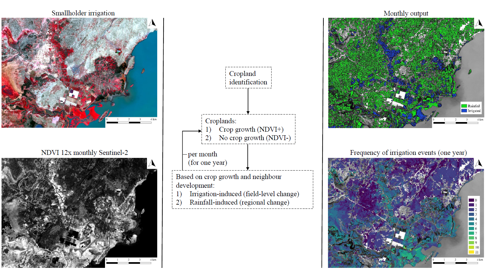
2.1. Data Collection and Preprocessing through the Google Earth Engine

Two type of products were derived from Sentinel-2 Top-Of-Atmosphere reflectance in the Google Earth Engine [32]. Firstly, a mosaic of images was created. All available images between October 2016 and March 2017 (9065 images), which captures most of the dry season for the Horn of Africa [33], were sorted by the image-associated ‘cloudy pixel percentage’. Then images with the lowest cloud percentage were selected resulting in a mosaic of best-cloud-free images (10 m: blue, green, red, NIR) for this period for the Horn of Africa. Secondly, monthly (September 2016 to August 2017) NDVI composites were computed by selecting the NDVI associated with the least-cloudy pixel from the Sentinel-2 collection in each month. This cloud-score calculation is an adaptation to the Landsat ‘Simple Cloud Score’ algorithm available in the Google Earth Engine library. The remaining clouds, i.e., where no cloud-free pixel was available during that month, were identified by visually selecting ‘cloud’ clusters following a clustering procedure (k-means). Based on this, monthly cloud masks were generated. The output from the Google Earth Engine then comprised: (1) one mosaic of best-cloud-free images between October and March (hereafter referred to as dry-season mosaic), which will be used for the segmentation to create the spatial units of interests (field level), and, (2) 12 monthly NDVI composites containing best-cloud-free pixels or masked pixels (hereafter referred to as NDVI composites), which are used to describe vegetation phenology for these spatial units.

2.2. Workflow of Mapping Irrigated Agriculture

Mapping monthly irrigated agriculture involved a segmentation step and two classification steps. Segmentation was performed on the dry-season mosaic to obtain the delineation of fields. Next, cropland objects were identified by a Random-Forest algorithm. Lastly, irrigated cropland was classified on a monthly basis using process-based rules on NDVI time series and surrounding fields.

2.2.1. Segmentation

An essential step in a GEOBIA approach is the segmentation of the image to represent the desired landscape elements, which are in this case the agricultural fields. The segmentation was conducted in eCognition® Developer [34]. Here, a multi-resolution segmentation [35] followed by a spectral difference merge was performed on the dry-season mosaic. The multi-resolution segmentation groups pixels on the basis of a heterogeneity threshold (scale parameter). The spectral-difference merge then merges objects based on a maximum spectral-difference threshold. For the multi-resolution segmentation, a heterogeneity threshold of 40, a shape parameter of 0.6, and a compactness parameter of 0.5 was used. This was followed by a spectral-difference merge where the maximum spectral difference was set at 50.

2.2.2. Training and Validation Data

A training and validation dataset were generated for the cropland classification. In the Horn of Africa, modern large-scale agriculture with well-developed irrigation infrastructure is present next to smallholder agriculture. As the appearance of both types differ strongly, both are explicitly included in the training and validation data to encompass all (irrigated) agriculture. Per sector, three areas were selected for object interpretation: (1) dominantly traditional smallholder croplands (0.5 × 0.5 km2), (2) dominantly modern large-scale croplands (1.0 × 1.0 km2), and (3) other land use and land cover (LULC) (1.0 × 1.0 km2). A total of 47,045 objects in these areas were visually labeled using the imagery in this study, World Imagery [36] and Google maps [37]. An object was discarded if it did not contain a dominant LULC (∼<75% coverage: 2049 objects) or if it could not be identified using the available data sources (669 objects). The selection of other LULC areas was purposely varied across sectors to represent all kinds of non-agricultural LULC. For some sectors not all three categories were included, because; (1) they could not clearly be identified with the available resources, or (2) they had cloud cover in the dry-season mosaic, or (3) they were absent (or unfound). Sectors with less than 20% area in the spatial extent of the Horn of Africa were not included in this dataset. Ultimately, 9632 objects were labeled as cropland and 34,695 objects as other LULC.
Objects with incomplete NDVI time series, i.e., with 100% cloud cover in one or more of the 12 monthly NDVI composites, were excluded from training data and added to the validation data (Table 1). Objects with complete NDVI time series were split 80%–20% into training and validation respectively.

2.2.3. Cropland Classification

The classification of cropland was performed by means of the Random-Forest algorithm. This statistical classifier builds multiple decision trees based on training data, i.e., a labeled class and associated variables [38]. LULC is then determined using a majority vote in the resulting Random Forest (Liaw and Wiener, 2002). It additionally computes variable importance, which is expressed by the Mean Decrease in Accuracy [38]. The Random Forest in this study was computed using the ‘randomForest’ package available in the R software environment [39,40] and was composed of 10,000 trees (other settings were set at default). Object variables were used as input for the classification; 16 spectral variables (4 bands of the dry-season mosaic; blue, green, red, NIR) and 12 times monthly NDVI), 4 texture variables (standard deviation), and 9 shape variables (Supplementary Materials S1). If the monthly NDVI was missing due to the presence of clouds, a value was computed by linear interpolation between months. The output is a map showing the spatial distribution of cropland and other LULC for the Horn of Africa.
Validation was performed by applying the Random Forest on the two validation sets (unused objects) and evaluating the outcome. The performance of the classification was expressed using overall accuracy, producer’s accuracy, user’s accuracy, and the kappa coefficient, which range from 0% (no match) to 100% (complete match). These are standard accuracy parameters for LULC classifications [41].

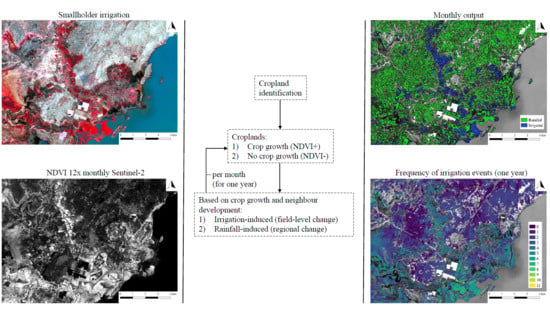
2.2.4. Irrigation Classification

Information on the local heterogeneity of NDVI development of neighbours was used to discriminate between irrigation- and rainfall-induced crop growth. Field-level changes are observed as a result of irrigation, while rainfall results in vegetation changes at a spatial extent larger than the field. Thus, when a cropland shows crop growth (increase in NDVI) and all neighbouring objects show similar NDVI development, it is assumed to be a rainfall-induced crop growth (spatially homogeneous development). However, if the neighbouring objects show different NDVI developments (spatially heterogeneous), then the observed crop growth in that cropland occurred at field level and is regarded as irrigation-induced.
Crop growth was assessed per cropland object on a monthly basis (NDVI differences between two months were assessed, e.g., between September and October) and were labeled as; crop growth or no crop growth. For each cropland showing crop growth, the percentage of all neighbouring objects in a radius of 5 km (cropland and other LULC) also showing vegetation growth was determined. A radius of 5 km was set to assure sufficient neighbours were included in each month. Non-vegetation objects were excluded (roads, water bodies, villages). Three different maps were created based on this percentage; at least 15%, 25%, and 35% percent (spatial-heterogeneity thresholds) of neighbouring objects should show no vegetation growth within the 5-km radius, to characterize the cropland growth of the cropland under consideration as an irrigated cropland, else it was classified as a rainfed cropland. For example, for the 15% threshold; at least 15% of the objects in a radius of 5 km should be labeled as no vegetation growth to characterize the crop growth of the cropland under consideration as irrigation-induced. Higher spatial-heterogeneity threshold values result in a smaller area of irrigated agriculture. Cropland objects showing no crop growth were categorized as rainfed cropland for the specific months. For a more detailed description of this process-based irrigation classification see Supplementary Materials S2. For croplands where monthly NDVI was absent due to the presence of clouds, irrigation status could not be determined, and they were excluded from the analysis for those specific months (labeled as no data). The output of this method then comprises three times eleven monthly land-use maps showing the spatial distribution of rainfed and irrigated croplands.
The different applied spatial-heterogeneity thresholds describe different levels of heterogeneity required to flag croplands as irrigated and are assumed to give an indication of the range of smallholder-irrigation extent using these process-based rules. Accordingly, the resulting maps give a characterisation of the spatial-temporal distribution of smallholder irrigated agriculture in the Horn of Africa. Validation of these maps was not possible due to the absence of ground truth. There are a few known smallholder irrigation schemes from visual interpretation of the imagery or from literature, although information on the temporal dynamics or frequency of irrigation events is absent. Also, there is little to no data on agricultural areas, which are solely rainfed. Consequently, determination of an optimal threshold is not possible at this point in time.

3. Results

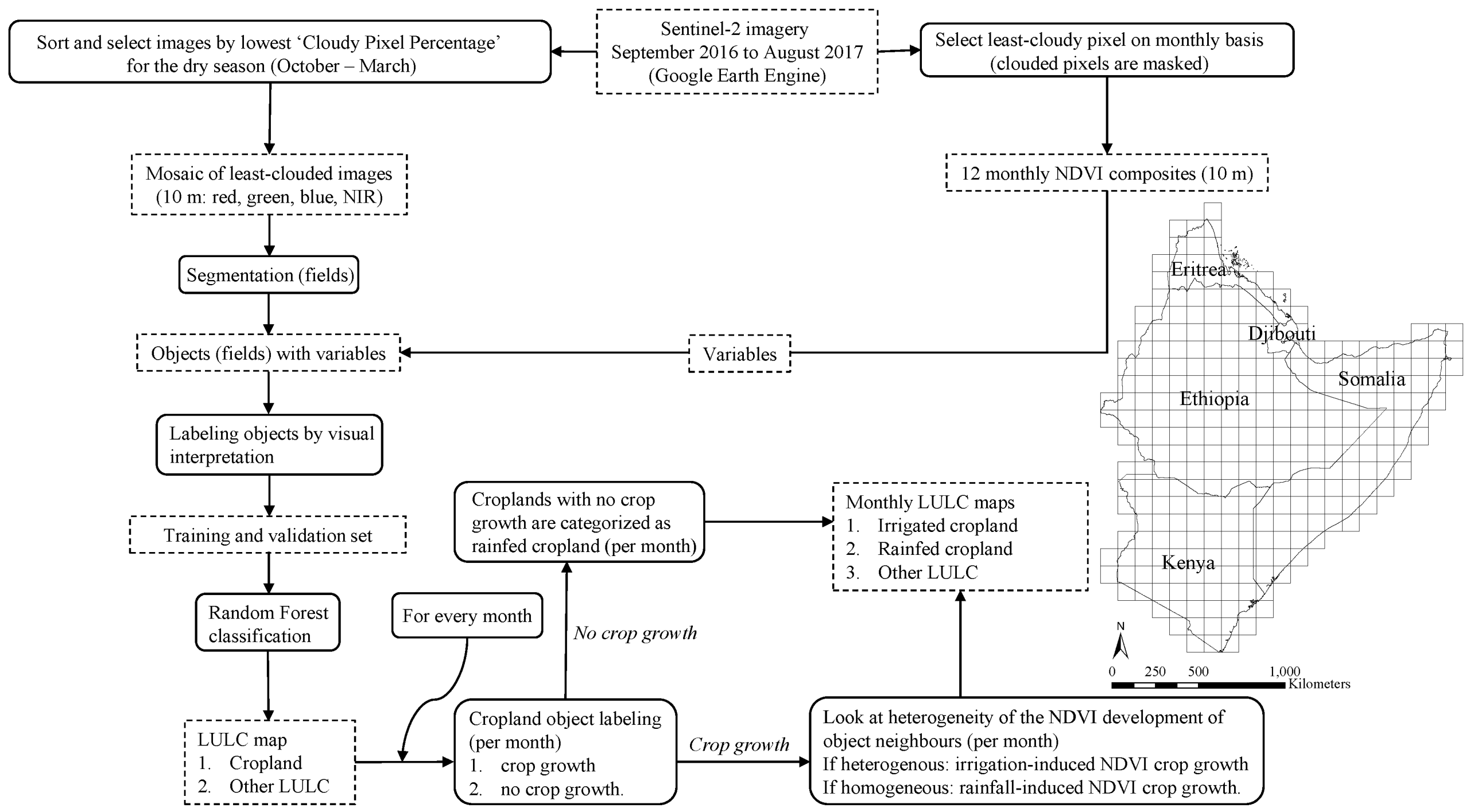
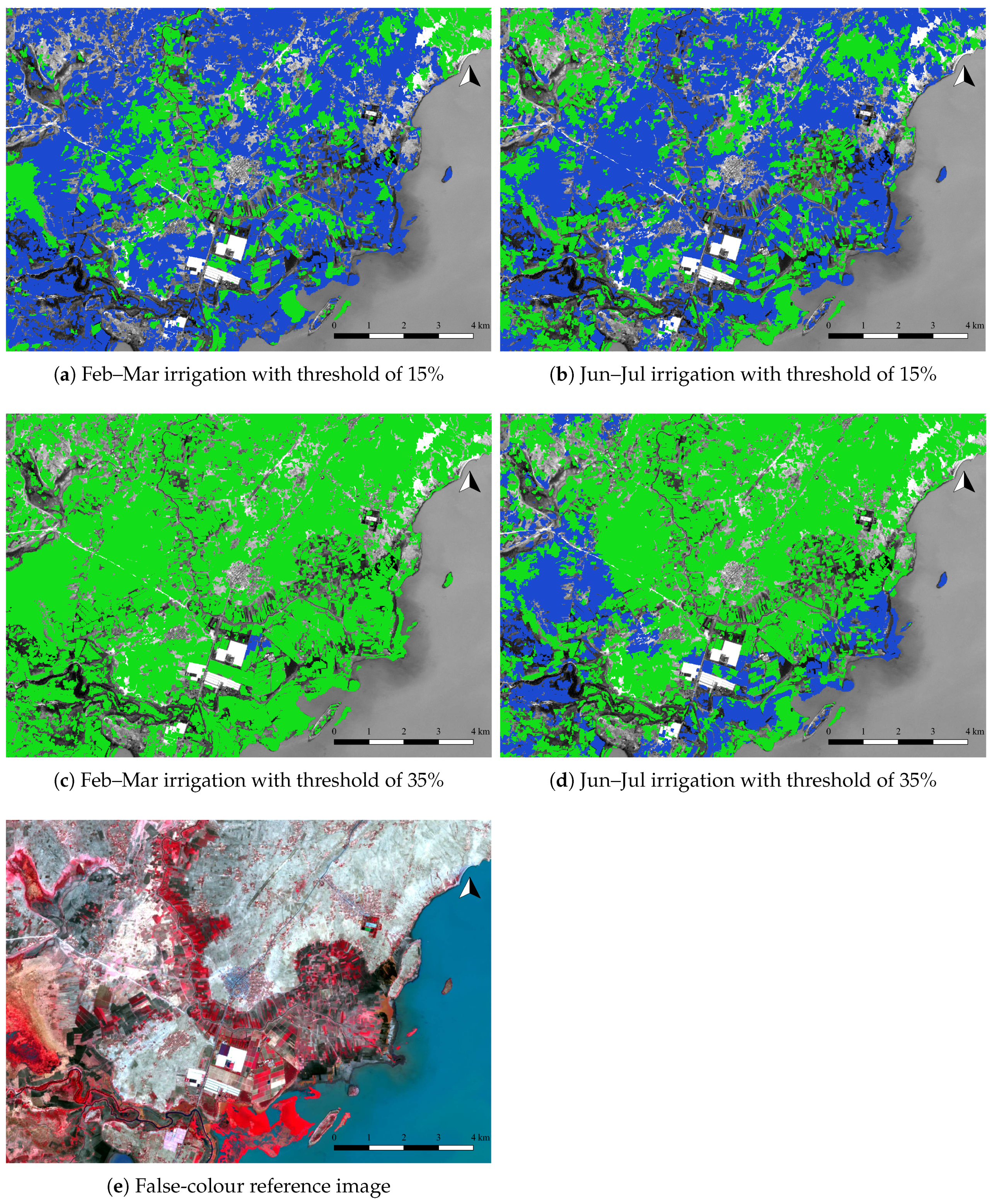
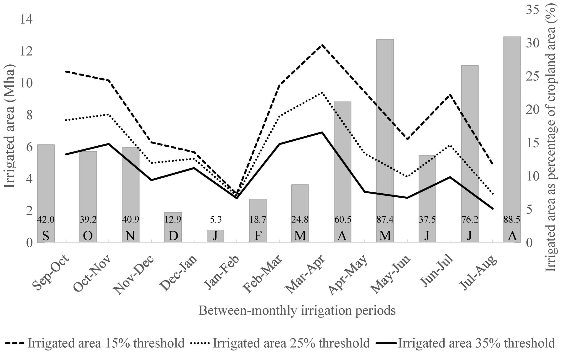
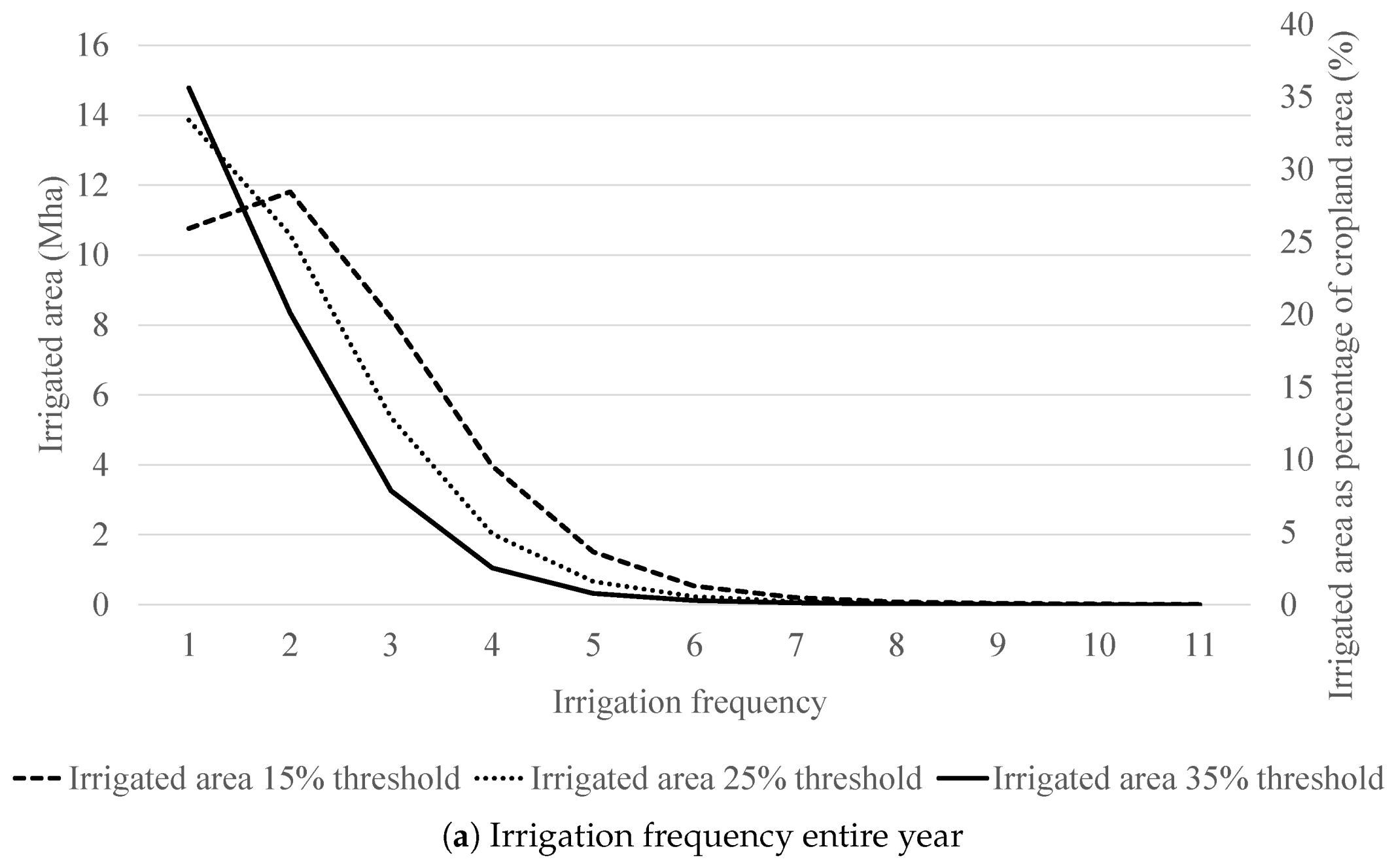
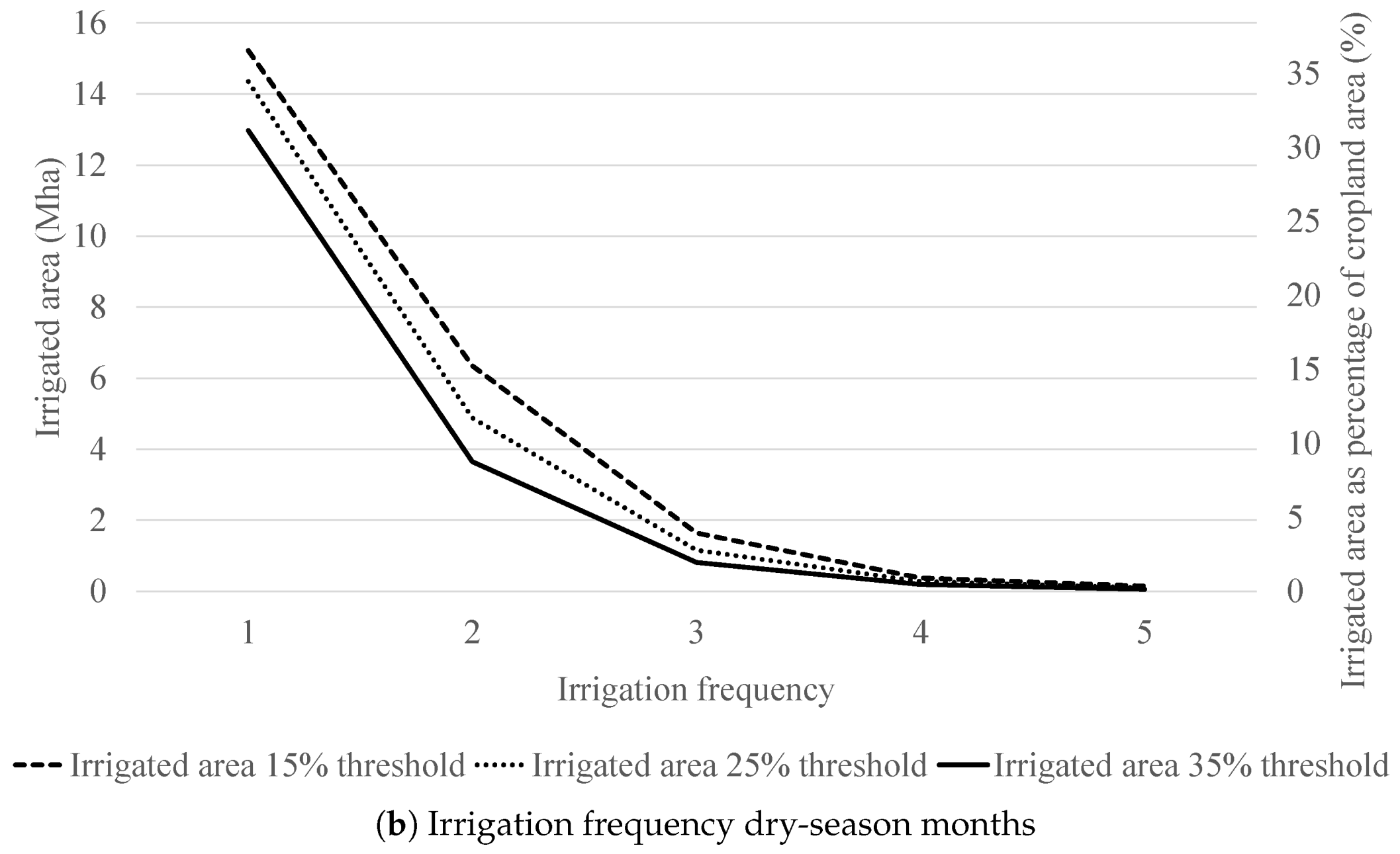
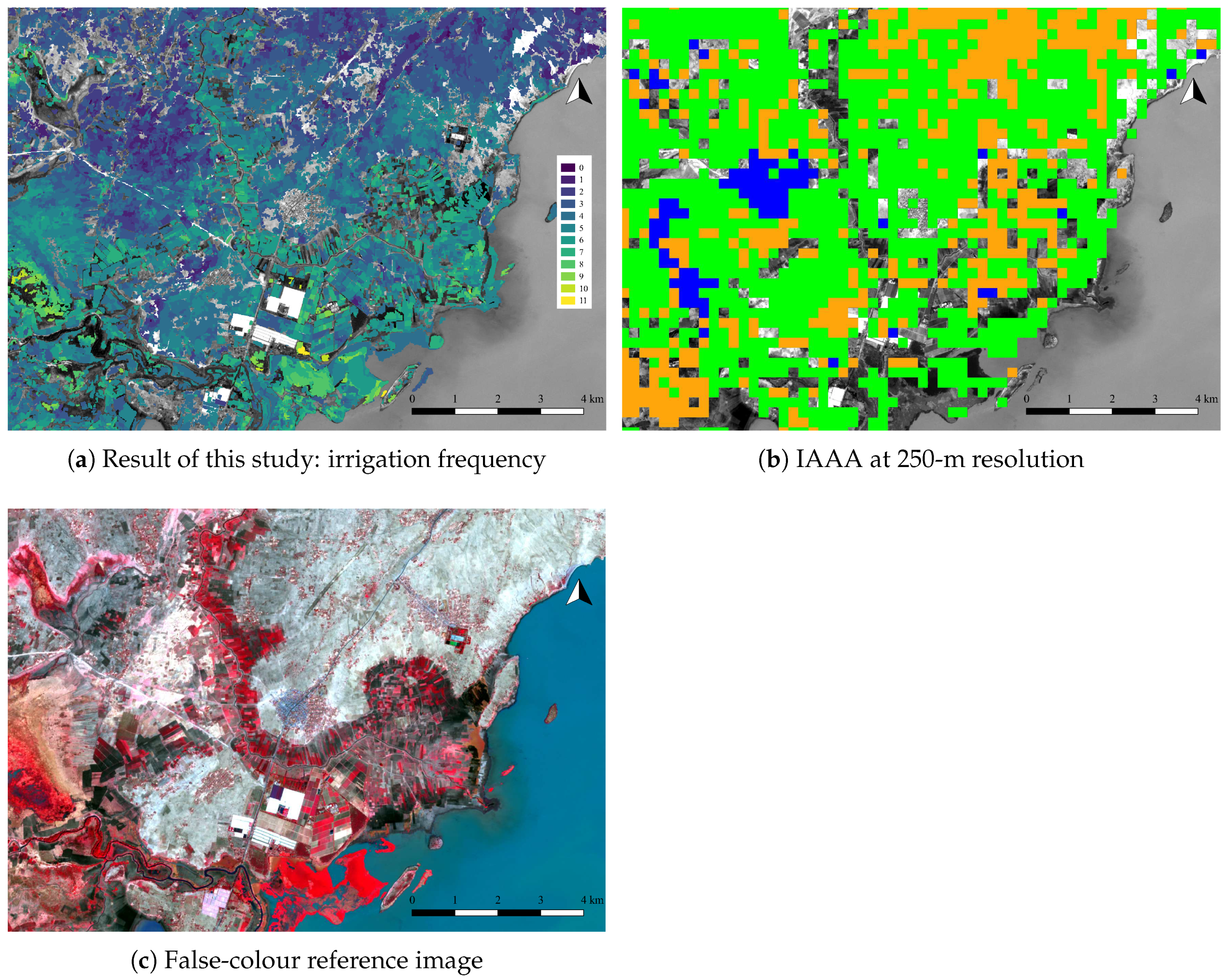
3.1. Irrigation Classification

Irrigated cropland was mapped for eleven (monthly) time steps and three spatial-heterogeneity thresholds for one year (September 2016 to August 2017) using process-based rules on NDVI and neighbourhood. Spatial-heterogeneity thresholds were applied to distinguish between irrigated and rainfed agriculture. The different threshold values provide an indication of the spatio-temporal range of irrigated agriculture in the Horn. The irrigation frequency (number of time steps with irrigation events) varies strongly, even locally (Figure 2). With higher spatial-heterogeneity threshold values, fewer objects are classified as irrigated agriculture (Figure 3).
The temporal dynamics of irrigated area in the Horn of Africa show similar patterns for the three maps (Figure 4). Irrigation occurs predominantly in April–May. Here, ∼30%, ∼23%, and ∼17% of cropland is irrigated for respectively the 15%, 25%, and 35% thresholds. The maximum irrigated area occurring in one month in the studied year ranges from 6.91 Mha (35% threshold) to 12.39 Mha (15% threshold). All maps show the smallest irrigated area in January–February (dry-season months). With decreasing rainfall at the start of the studied period, the occurrence of irrigation also decreases, although there is a small increase in irrigation in October–November and December–January periods for the 25% and 35% threshold maps. The steepest increase of irrigated area for all thresholds occurs when rainfall increases again in February and March. The high rainfall of May corresponds with a decrease in irrigated area.
The irrigation frequency that the croplands in the Horn of Africa experience differ per threshold (Figure 5). The 15% threshold shows a different pattern compared to the 25% and 35% thresholds. The largest part of the irrigated area experiences two irrigation events for the 15% threshold, while for the 25% and 35% thresholds, the largest part of the irrigated area experiences only a single irrigation event. Total irrigated-cropland area in the studied year in the Horn of Africa is 37.13 Mha, 32.87 Mha, and 27.96 Mha for respectively the 15%, 25%, and 35% thresholds. Total irrigated-cropland area in the dry season (October–November to February–March) in the Horn of Africa is 23.72 Mha, 20.75 Mha, and 17.67 Mha for respectively the 15%, 25%, and 35% thresholds.

3.2. Quality of the Maps

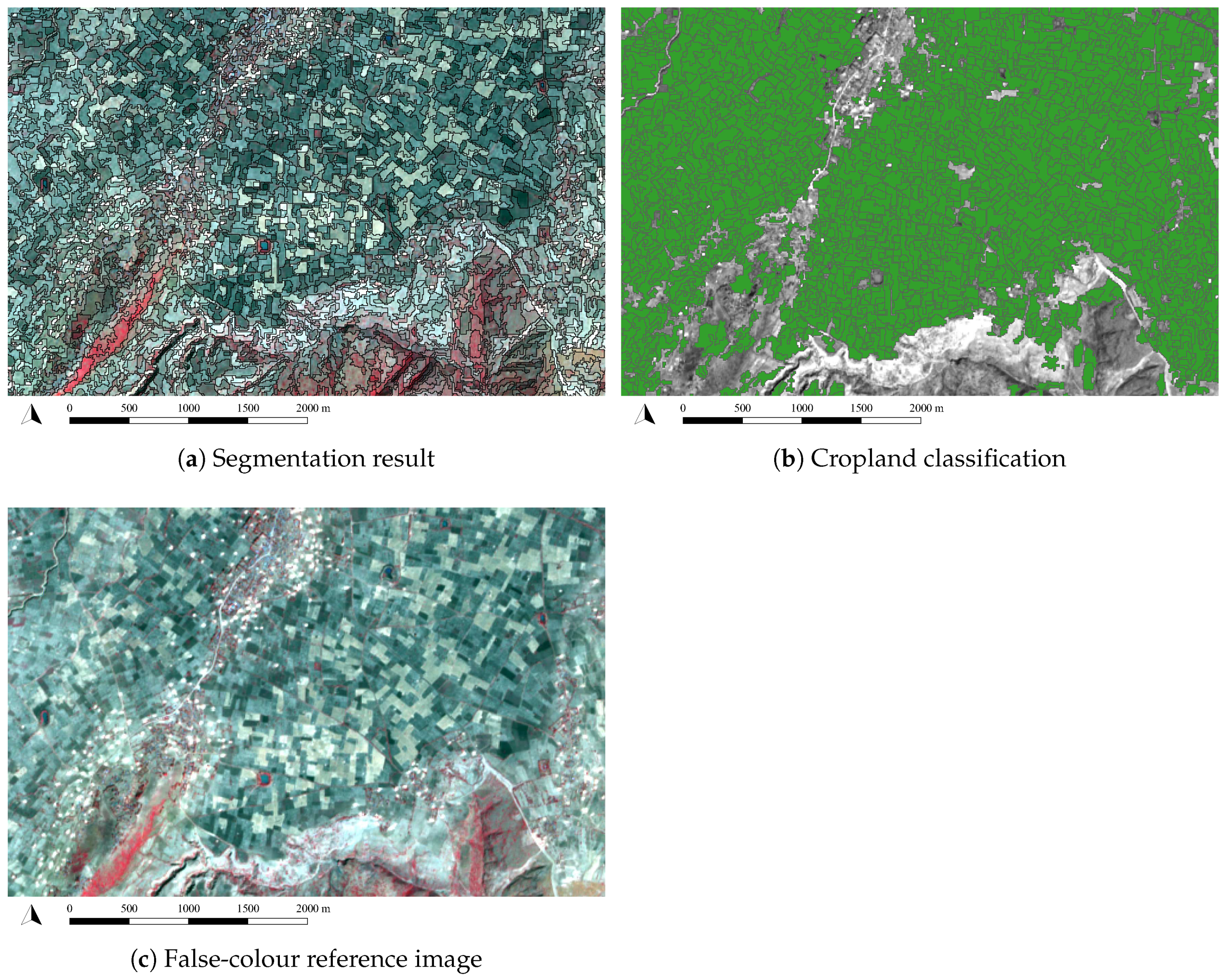
3.2.1. Delineation of Croplands

The segmentation parameters in this study were chosen such that agricultural fields were optimally delineated (Figure 6). This was quite challenging for such a large area, because delineation optimization efforts resulted in improvements in some areas, but poor results in others. Therefore, a simple segmentation ruleset was adopted (Section 2.2.1), which from visual interpretation seemed to work best throughout the Horn of Africa. The performance of the segmentation for the Horn of Africa was not quantified. Generally, individual fields were delineated best if the spectral difference to neighbouring fields was high. The segmentation was performed on the dry-season mosaic, when contrast between rainfed agricultural fields is relatively low, while irrigation will enhance contrast between fields, whether irrigated or rainfed. Consequently, multiple rainfed fields were clumped into one object more often than irrigated fields. Very small fields were generally included in a larger object, because the spatial resolution (10 m) was insufficient.

3.2.2. Validation of Cropland Classification

Cropland classification was performed at object level (Figure 6). The classification relied primarily on a combination of monthly NDVI variables, spectral variables and texture variables (Supplementary Materials S3). Shape variables were not important for the classification. Accuracy statistics for the cropland classification are high with an overall accuracy and kappa coefficient of 96% and 0.73 respectively with high user’s and producer’s accuracies for both classes (Table 2A). Accuracy statistics were calculated separately for a validation set with complete NDVI information for the 12 months (Table 2B) and for a validation set with incomplete NDVI time series, which uses interpolated NDVI values (Table 2C). Generally, more than 9 months of NDVI information were available (Supplementary Materials S4). The validation set on incomplete NDVI time series has a much lower availability of monthly NDVI compared to the entire Horn of Africa, e.g., ∼90% surface area of the Horn of Africa has eleven or twelve months of NDVI values compared to 74% of the surface area in this validation set. These performance statistics can therefore be considered as minimum performance. The validation set with interpolated NDVI values shows a much lower performance and a distinct drop in user’s and producer’s accuracy for cropland is observed. However, it should be noted that an NDVI value is obtained for an object as long as at least one not-clouded pixel is available. Only if all pixels composing an object are masked in a particular month, the object receives the no-data label for that month and an interpolated value is used.

4. Discussion

4.1. Comparison of Irrigation Maps with Other Products

The new methodology presented here results in monthly maps of irrigated agriculture at 10-m resolution for the Horn of Africa from September 2016 to August 2017. The total mapped cropland area is 41.67 Mha, which equals ∼17% of the surface area. Table 3 shows an overview of different land-use products covering the Horn of Africa. The cropland mapping result of this study is in line with the most recent cropland mapping study at 30-m resolution (GFSAD30AFCE). There, ∼15% of the Horn of Africa was mapped as cropland.
Classification of irrigated agriculture using the process-based rules with different spatial-heterogeneity thresholds resulted in a range (between the 35% and 15% thresholds) of 27.96–37.13 Mha irrigated agriculture (Table 3). This study mapped the minimum number of irrigation events as crop growth (subsequently irrigation mapping) can remain undetected as a result of how the monthly NDVI composites are created (best cloud-free pixel) or could not be calculated for a particular month as a result of cloud cover. The confusion matrix of the cropland classification shows an underestimation (lower user’s accuracy) of cropland area and thus subsequently irrigated cropland. Existing estimates for irrigated agriculture in the Horn of Africa are; 8.17 Mha (IAAA), 0.0004 Mha (Globcover2009), 9.93 MHa (GFSAD1000: GIAM), 0.95 Mha according to (GMIA), and 1.23 (AQUASTAT) (Table 3). If water-managed croplands are included, the estimates from IAAA and AQUASTAT are 22.39 Mha and 2.33 Mha respectively. A monthly specification of irrigated agriculture, like produced in this study, is absent for all compared products.
The estimates of irrigated agriculture in this study are approximately 2.8 to 3.7 times larger than the current highest estimate, the GIAM (1000-m spatial resolution), and 1.2 to 1.7 times larger than the IAAA (250-m spatial resolution), when including water-managed non-irrigated croplands. If only the dry-season months (October–November to February–March) were considered, the estimates of irrigated agriculture range from 17.7 Mha (35% threshold) to 23.72 Mha (15% threshold). The irrigation frequency, the number of time steps with an irrigation event, varies. The irrigated area that experienced three or more irrigation events between September 2016 and August 2017 was 4.83 Mha (dry season: 1.06 Mha) for the 35% threshold and 14.56 Mha (dry season: 2.15 Mha) for the 15% threshold. Most of the irrigated area experienced only one to two irrigation events (Table 3). The spatial patterns differ from other available maps, e.g., Figure 7 depicts the IAAA at 250-m spatial resolution, which is the current highest-resolution map on irrigated agriculture. Here, the differences in spatial resolution (10 m versus 250 m) as well as the differences in the location of irrigated agriculture are striking. The differences in spatial patterns are not surprising considering that cropland fields are generally below a hectare in size [8], thus well below the detection limit of 250-m pixels. A study on resolution-dependent irrigation mapping in India found that with higher spatial resolution a higher estimate of irrigated area was achieved [24]. Therefore, the higher spatial resolution of the maps in this study compared to other sources was expected to lead to higher estimates of irrigated agriculture and yield more realistic results.
Irrigation studies mainly focus on areas with established irrigation infrastructure [49]. Areas using other irrigation sources, such as river and stream diversions (Figure 8) or farm dams, are often not accounted for [49], while these are characteristic for low- and middle-income countries. The IAAA and AQUASTAT datasets already specify irrigated agriculture, and, water-managed agriculture. The process-based approach in this study is not restricted to a certain type of irrigation; it encompasses all types of water application at field level that are not a result of rainfall. It is unique in that it adds a temporal specification and is able to separate crop growth in a rainfall and irrigation component (even in the rainy season). All crop growth is considered, which includes small and large vegetation changes. These aspects likely add to the higher estimates of irrigated area in this study. The high temporal resolution (monthly) of this study highlights the dynamics of irrigation in space and time throughout the seasons and gives a more complete and extended view on the extent of irrigated agriculture in the Horn of Africa.

4.2. Quality of the Irrigation Maps

Accuracy statistics for the cropland classification are high, overall accuracy and kappa coefficient are 96% and 0.73 respectively, but decrease when the availability of monthly NDVI (Supplementary Materials S4) is reduced due to cloud coverage. As a result, some regions have better cropland classification than others. A single ruleset was adopted for the segmentation, which does not account for geographic variability. It would be easier to define and optimize segmentation parameters for smaller areas, e.g., country-wise, but this would require multiple individual analysis runs. Here, ground truth was collected throughout the Horn of Africa to compute the confusion matrices, which show a good performance of the cropland classification, i.e., geographic variability did not have a negative effect on the classification. The temporal pattern of irrigated area generally follows the temporal pattern of rainfall and is highly dynamic through time. The dry season is characterized by low irrigated area, which is not really surprising since most irrigation practices in the Horn of Africa use surface water. An example is spate irrigation, which is dependent on seasonal floods to fill water-storage channels [50]. The availability of surface water is extremely low at the end of the dry season, which explains the small area of irrigated area in January–February. Also, the studied year was an extremely dry year. The extent of irrigated area is largest during the wetter months. Common perception is that irrigation is only needed during the dry season, but the amount of rainfall in the rainy season often does not meet the crop requirements, and irrigation is also applied throughout the rainy season [10,51]. Rainwater harvesting practices increase the resilience towards drought spells during the crop growing seasons (rainy seasons) by applying full or supplemental irrigation. The temporal dynamics of irrigated agriculture in this study correspond with the surface-water dominated irrigation practices in the Horn of Africa as it confirms that irrigation intensifies with increased surface-water availability at the start of the rainy season.
Cost and logistical challenges hamper the collection of reliable field validation data in remote data-poor regions [52]. Adding to that challenge is that irrigated agriculture is highly dynamic in time, administration of irrigation schemes on timing and magnitude is absent, and unofficial irrigation, by farm dams or river and stream diversions (Figure 8a), i.e., without established irrigation infrastructure, is unknown and unregulated. Ground truth data on purely rainfed agricultural areas is not available and it cannot be established from visual interpretation of imagery which fields exclusively receive rainfall. To validate the GIAM, 11.000+ locations were labeled as either rainfed or irrigated cropland from Google Earth imagery based on visual indicators such as shape (e.g., central pivot circles), size (e.g., reservoir size), pattern (e.g., contiguous cropland) and texture (e.g., the rougher texture of a natural forest as compared to the smooth texture of a cropland on a farm). However, this is an improbable approach for the complex smallholder-dominated agricultural landscape in Africa as it is impossible to determine if areas are purely rainfed from Google Earth imagery, e.g., spate irrigation systems are impossible to detect based on these visual indicators (Figure 8b). Consequently, no data on either rainfed or irrigated agriculture, nor the number of irrigation events were available to validate the findings from our study. Visual comparison with some known existing schemes (Supplementary Materials S5) shows that all thresholds are able to grasp irrigated agriculture there, though the number of irrigation events differ for each threshold. A too low threshold might describe too little heterogeneity of the NDVI development of neighbours to classify crop growth to be a result of irrigation. On the other hand, a too high threshold would give errors for larger contiguous irrigation schemes. Ideally, extensive ground truth is attained on rainfed agricultural areas, which are not water-managed in any manner, to be able to calibrate an appropriate threshold. In this manner, calibration of the number of irrigation events can be performed, as these purely rainfed areas can be set to zero irrigation events.

4.3. Applicability of the Method and Irrigation Maps

The development of sustainable irrigation infrastructure is fundamental to achieve domestic food security in the drought-prone Horn of Africa [13]. Smallholder irrigation development is adopted as the main strategy by international development policy to improve food security at the domestic level [14,15,16,17]. Pivotal to this objective is the understanding of current spatio-temporal distributions of smallholder irrigated agriculture. However, existing LULC maps with a resolution of 250 m or coarser cannot dissect smallholder-dominated complex agricultural landscapes [18,22,23]. This study improved the spatial resolution of irrigated-agriculture mapping by a factor 625 and added a monthly temporal component to highlight the dynamics of irrigated agriculture. The GEOBIA workflow developed in this study applied a knowledge-based processing chain and shows the feasibility to give an indication of spatio-temporal patterns of (smallholder) irrigation over large areas purely based on remote sensing. The input data consist solely of satellite images, which are available for any region in the world. Universal characteristics regarding the local context of irrigated agriculture are used for the classification. Therefore, it seems feasible to apply the method in other (semi-)arid regions, which is especially valuable in the context of food security and water availability for large data-poor regions in low- and middle-income countries. It will most likely yield better results if a smaller extent is chosen, as the segmentation can then be optimized to local fields and ground truth data for calibration and validation of thresholds is more representative. Large-scale mapping at high-resolution with small landscape elements will remain a challenge, but calibration and validation would benefit from appropriate field data. Field programs such as the Degree Confluence Project, which aims to visit and describe each latitude and longitude integer degree intersections in the world [54] or the Global Food Security Support Analysis Data (GFSAD) project Validation Dataset [55], which combines high-resolution satellite interpretation and field data of LULC, are extremely valuable. Expanding such field databases with detailed information on crop types and water sources, would be beneficial for all mapping and validation efforts regarding remote-sensing products on food security and water availability in data-poor regions.

5. Conclusions

A novel method was presented to map the spatio-temporal patterns of irrigated agriculture at field level in the Horn of Africa. Process-based rules on NDVI time series and neighbouring objects were applied on Sentinel-2 imagery. The results show that it is feasible to map the location, moment and frequency of irrigation events purely from remote-sensing based observations. The feasibility to apply this method in other (semi-)arid regions is high, because the workflow is based on universal characteristics about the local context of irrigated agriculture and is not affected by geographic variability. The workflow provides a minimum estimate of irrigation events as either crop growth and irrigation can remain undetected due to the presence of cloud cover, or as an artefact of NDVI-composite creation (best cloud-free pixel per month). Currently, it is impossible to determine which spatial-heterogeneity threshold is most appropriate as reference data are not available. Consequently, this study shows an estimated range of irrigated area for the Horn of Africa. To calibrate an appropriate heterogeneity threshold, which separates irrigated from rainfed agriculture, ground truth on purely rainfed agriculture (no water management in any form) is required. The temporal pattern of irrigated agriculture follows the seasons; increased rainfall results in a higher availability of surface water, the main water source for irrigation for smallholder agriculture. The estimated irrigated area in this study (27.96 Mha to 37.13 Mha) is much higher than values reported in literature, which are based on much coarser spatial-resolution data and have no temporal specification of irrigation events. Therefore, they are expected to provide lower estimates of irrigated area. If only the dry season is considered, estimates in this study range from 17.67 Mha to 23.72 Mha of irrigated agriculture in the Horn. The distinction between low irrigation (1–2 events) and high irrigation (3+ events) frequency leads to irrigated-area estimates of 22.57 Mha to 23.13 Mha (35% to 15%) and 4.83 Mha to 14.56 Mha (35% to 15%), respectively. Generally, studies in literature focus on mapping areas with established irrigation infrastructure, which is highlighted in the dry season. This study provides a method to assign crop development to either irrigation or rainfall, even in the rainy season, and therefore captures all types of water-managed agricultural areas. The irrigation maps produced here are currently the highest-resolution (both spatially and temporally) available for the Horn of Africa and might serve as a framework for irrigation-development policy, irrigation optimization, assessment of irrigation efficiency, and catchment studies on the effect of smallholder irrigation on the water cycle.

Supplementary Materials

The following are available online at https://www.mdpi.com/2072-4292/11/2/143/s1, S1: Overview of object variables Random-Forest classification, S2: Process-based rules for irrigation classification, S3: Variable importance of the Random Forest, S4: Overview of availability monthly NDVI information, S5: Illustrations classification irrigation schemes. An illustration of the output for a subset area in the Central Rift Valley, Ethiopia, can be found on: https://public.yoda.uu.nl/geo/UU01/F2P7EQ.html (DOI:10.24416/UU01-F2P7EQ).

Author Contributions

Conceptualization, M.F.A.V.; Data curation, M.F.A.V.; Formal analysis, M.F.A.V. and H.D.; Methodology, M.F.A.V.; Writing—original draft, M.F.A.V.; Writing—review & editing, M.F.A.V., E.A.A., S.M.d.J. and G.S.

Funding

This research was funded by Climate-KIC (Task ID: ARED0004_2013-1.1-008_P001-06).

Conflicts of Interest

The authors declare no conflict of interest.

References

  1. Pricope, N.G.; Husak, G.; Lopez-carr, D.; Funk, C.; Michaelsen, J. The climate-population nexus in the East African Horn: Emerging degradation trends in rangeland and pastoral livelihood zones. Glob. Environ. Chang. 2013, 23, 1525–1541. [Google Scholar] [CrossRef]
  2. Sidahmed, A. Recent trends in drylands and future scope for advancement. In Climate Variability Impacts on Land Use and Livelihoods in Drylands; Gaur, M., Squires, V., Eds.; Springer International Publishing AG: Cham, Switzerland, 2018; p. 32. [Google Scholar]
  3. FAO. Horn of Africa Cross-Border Drought Action Plan 2017; Food and Agriculture Organization of the United Nations: Rome, Italy, 2017. [Google Scholar]
  4. Funk, C.C.; Brown, M.E. Declining global per capita agricultural production and warming oceans threaten food security. Food Secur. 2009, 1, 271–289. [Google Scholar] [CrossRef] [Green Version]
  5. Thornton, P.K.; Jones, P.G.; Alagarswamy, G.; Andresen, J. Spatial variation of crop yield response to climate change in East Africa. Glob. Environ. Chang. 2009, 19, 54–65. [Google Scholar] [CrossRef]
  6. Salami, A.; Kamara, A.B.; Brixiova, Z. Smallholder Agriculture in East Africa: Trends, Constraints and Opportunities; Technical Report; African Development Bank: Tunis, Tunisia, 2010. [Google Scholar]
  7. Rockström, J. Water resources management in smallholder farms in Eastern and Southern Africa: An overview. Phys. Chem. Earth Part B Hydrol. Oceans Atmos. 2000, 25, 275–283. [Google Scholar] [CrossRef]
  8. Abate, T.; Van Huis, A.; Ampofo, J.K.O. Pest management strategies in traditional agriculture: An African perspective. Annu. Rev. Entomol. 2000, 45, 631–659. [Google Scholar] [CrossRef] [PubMed]
  9. Hansen, J.W.; Mason, S.J.; Sun, L.; Tall, A. Review of seasonal climate forecasting for agriculture in sub-saharan Africa. Exp. Agric. 2011, 47, 205–240. [Google Scholar] [CrossRef]
  10. Oya, T.; Inada, K.; Tsutsui, Y.; Lemma, G.; Kebebew, B.; Suzuki, S.; Takahashi, S. Trial on supplemental irrigation technology during rainy season in semi-arid area of Ethiopia. J. Arid Land Stud. 2012, 22, 211–214. [Google Scholar]
  11. Lebdi, F. Irrigation for Agricultural Transformation; Technical Report; African Center for Economic Transformation (ACET) and Japan International Cooperation Agency Research Institute (JICA-RI): Accra, Ghana, 2016. [Google Scholar]
  12. USGS. Irrigation Water Use: Surface Irrigation. 2016. Available online: https://water.usgs.gov/edu/irfurrow.html (accessed on 12 September 2017).
  13. FAO. Economic Valuation of Water Resources in Agriculture: From the Sectoral to a Functional Perspective of Natural Resource Management; Water Reports No. 27; Food and Agriculture Organization of the United Nations: Rome, Italy, 2004. [Google Scholar]
  14. IAC. Realizing the Promise and Potential of African Agriculture: Implementation of Recommendations and Action Agenda; InterAcademy Council: Amserdam, The Netherlands, 2004. [Google Scholar]
  15. World Bank. World Development Report 2008: Agriculture for Development; World Bank: Washington, DC, USA, 2008. [Google Scholar]
  16. Tschirley, D. What Is the Scope for Horticulture to Drive Smallholder Poverty Reduction in Africa? Policy Synthesis; Technical Report; USAID, University of Michigan: Ann Arbor, MI, USA, 2011. [Google Scholar]
  17. Burney, J.A.; Naylor, R.L. Smallholder Irrigation as a Poverty Alleviation Tool in Sub-Saharan Africa. World Dev. 2012, 40, 110–123. [Google Scholar] [CrossRef]
  18. Beekman, W.; Veldwisch, G.J.; Bolding, A. Identifying the potential for irrigation development in Mozambique: Capitalizing on the drivers behind farmer-led irrigation expansion. Phys. Chem. Earth Parts A/B/C 2014, 76–78, 54–63. [Google Scholar] [CrossRef]
  19. Siddiqui, S.; Cai, X.; Chandrasekharan, K. Irrigated Area Map Asia and Africa (International Water Management Institute). 2018. Available online: http://waterdata.iwmi.org/applications/irri{_}area/ (accessed on 8 May 2018).
  20. Siebert, S.; Henrich, V.; Frenken, K.; Burke, J. Update of the Digital Global Map of Irrigation Areas to Version 5; Technical Report; Institute of Crop Science and Resource Conservation Rheinische Friedrich- Wilhelms-Universität: Bonn, Germany, 2013. [Google Scholar]
  21. Thenkabail, P.S.; Biradar, C.M.; Noojipady, P.; Dheeravath, V.; Li, Y.; Velpuri, M.; Gumma, M.; Gangalakunta, O.R.P.; Turral, H.; Cai, X.; et al. Global irrigated area map (GIAM), derived from remote sensing, for the end of the last millennium. Int. J. Remote Sens. 2009, 30, 3679–3733. [Google Scholar] [CrossRef]
  22. Bégué, A.; Arvor, D.; Bellon, B.; Betbeder, J.; De Abelleyra, D.; Ferraz, R.P.D.; Lebourgeois, V.; Lelong, C.; Simões, M.; Verón, S.R. Remote sensing and cropping practices: A review. Remote Sens. 2018, 10, 99. [Google Scholar] [CrossRef]
  23. Ozdogan, M.; Yang, Y.; Allez, G.; Cervantes, C. Remote sensing of irrigated agriculture: Opportunities and challenges. Remote Sens. 2010, 2, 2274–2304. [Google Scholar] [CrossRef]
  24. Velpuri, N.M.; Thenkabail, P.S.; Gumma, M.K.; Biradar, C.; Dheeravath, V.; Noojipady, P.; Yuanjie, L. Influence of resolution in irrigated area mapping and area estimation. Photogramm. Eng. Remote Sens. 2009, 75, 1383–1395. [Google Scholar] [CrossRef]
  25. Blaschke, T.; Hay, G.J.; Kelly, M.; Lang, S.; Hofmann, P.; Addink, E.; Queiroz Feitosa, R.; Van der Meer, F.; Van der Werff, H.; Van Coillie, F.; et al. Geographic Object-Based Image Analysis—Towards a new paradigm. ISPRS J. Photogramm. Remote Sens. 2014, 87, 180–191. [Google Scholar] [CrossRef] [PubMed]
  26. Xiong, J.; Thenkabail, P.S.; Tilton, J.C.; Gumma, M.K.; Teluguntla, P.; Oliphant, A.; Congalton, R.G.; Yadav, K.; Gorelick, N. Nominal 30-m cropland extent map of continental Africa by integrating pixel-based and object-based algorithms using Sentinel-2 and Landsat-8 data on Google Earth Engine. Remote Sens. 2017, 9, 1065. [Google Scholar] [CrossRef]
  27. Lebourgeois, V.; Dupuy, S.; Vintrou, É.; Ameline, M.; Butler, S.; Bégué, A. A combined random forest and OBIA classification scheme for mapping smallholder agriculture at different nomenclature levels using multisource data (simulated Sentinel-2 time series, VHRS and DEM). Remote Sens. 2017, 9, 259. [Google Scholar] [CrossRef]
  28. Lambert, M.J.; Sibiry Traore, P.C.; Blaes, X.; Baret, P.; Defourny, P. Remote Sensing of Environment Estimating smallholder crops production at village level from Sentinel-2 time series in Mali’s cotton belt. Remote Sens. Environ. 2018, 216, 647–657. [Google Scholar] [CrossRef]
  29. Vogels, M.; Addink, E.; Sterk, G.; Jong, S. Mapping irrigated agriculture in complex landscapes using SPOT6 imagery and object-based image analysis—A case study in the Central Rift Valley, Ethiopia. Int. J. Appl. Earth Obs. Geoinf. 2019, 19, 118–229. [Google Scholar] [CrossRef]
  30. Al-Bakri, J.T.; Suleiman, A.S. NDVI response to rainfall in different ecological zones in Jordan. Int. J. Remote Sens. 2004, 25, 3897–3912. [Google Scholar] [CrossRef]
  31. FEWSNET. Illustrating the Extent and Severity of the 2016/17 Horn of Africa Drought; Technical Report; Famine Early Warning Systems Network. 2017. Available online: https://fews.net/sites/default/files/documents/reports/FEWS_NET_Horn_of_Africa_June%202017_Drought_Map_Book.pdf (accessed on 29 December 2018).
  32. Google Earth Engine Team. Google Earth Engine: A Planetary-Scale Geo-Spatial Analysis Platform. 2017. [Google Scholar]
  33. Nicholson, S.E. Climate and climatic variability of rainfall over eastern Africa. Rev. Geophys. 2017, 55, 590–635. [Google Scholar] [CrossRef]
  34. Trimble. eCognition Developer 9.3 Reference Book; Trimble Germany Documentation: Munchen, Germany, 2017. [Google Scholar]
  35. Baatz, M.; Schäpe, A. Multiresolution Segmentation: An Optimization Approach for High Quality Multi-Scale Image Segmentation; Angew. Geogr. Info. Verarbeitung; Wichmann-Verlag: Heidelberg, Germany, 2000; pp. 12–23. [Google Scholar]
  36. ESRI. ArcGIS Online Standard Service: World Imagery Collection, Map Server. Maps Throughout This Book Were Created Using ArcGIS® Software by ESRI. ArcGIS® and ArcMapTM Are the Intellectual Property of ESRI and Are Used Herein under License, Copyright ©ESRI. 2018. Available online: https://www.arcgis.com/index.html (accessed on 7 February 2018).
  37. Google Maps. 2017. Available online: https://www.google.nl/maps/place/Metehara (accessed on 7 June 2018).
  38. Breiman, L. Random forests. Mach. Learn. 2001, 45, 5–32. [Google Scholar] [CrossRef]
  39. Liaw, A.; Wiener, M. Classification and Regression by randomForest. R News 2002, 2, 18–22. [Google Scholar] [CrossRef]
  40. R Development Core Team. R: A Language and Environment for Statistical Computing; R Foundation for Statistical Computing: Vienna, Austria, 2017. [Google Scholar]
  41. Lillesand, T.; Kiefer, R.; Chipman, J. Remote Sensing and Image Interpretation, 6th ed.; John Wiley & Sons: New York, NY, USA, 2015; p. 483. [Google Scholar]
  42. Funk, C.; Peterson, P.; Landsfeld, M.; Pedreros, D.; Verdin, J.; Shukla, S.; Husak, G.; Rowland, J.; Harrison, L.; Hoell, A.; Michaelsen, J. The climate hazards infrared precipitation with stations—A new environmental record for monitoring extremes. Sci. Data 2015, 2. [Google Scholar] [CrossRef] [PubMed]
  43. Chen, J.; Chen, J.; Liao, A.; Cao, X.; Chen, L.; Chen, X.; He, C.; Han, G.; Peng, S.; Lu, M.; et al. Global land cover mapping at 30 m resolution: A POK-based operational approach. ISPRS J. Photogramm. Remote Sens. 2015, 103, 7–27. [Google Scholar] [CrossRef]
  44. Xiong, J.; Thenkabail, P.S.; Gumma, M.K.; Teluguntla, P.; Poehnelt, J.; Congalton, R.G.; Yadav, K.; Thau, D. Automated cropland mapping of continental Africa using Google Earth Engine cloud computing. ISPRS J. Photogramm. Remote Sens. 2017, 126, 225–244. [Google Scholar] [CrossRef]
  45. Arino, O.; Gross, D.; Ranera, F.; Leroy, M.; Bicheron, P.; Brockman, C.; Defourny, P.; Vancutsem, C.; Achard, F. GlobCover: ESA service for global land cover from MERIS. In Proceedings of the IEEE International Geoscience and Remote Sensing Symposium, Barcelona, Spain, 23–27 July 2007; pp. 2412–2415. [Google Scholar]
  46. Salmon, J.M.; Friedl, M.A.; Frolking, S.; Wisser, D.; Douglas, E.M. Global rain-fed, irrigated, and paddy croplands: A new high resolution map derived from remote sensing, crop inventories and climate data. Int. J. Appl. Earth Obs. Geoinf. 2015, 38, 321–334. [Google Scholar] [CrossRef]
  47. Teluguntla, P.; Thenkabail, P.S.; Xiong, J.; Gumma, M.K.; Giri, C.; Milesi, C.; Ozdogan, M.; Congalton, R.G.; Tilton, J.; Sankey, T.T.; et al. Global Food Security Support Analysis Data at nominal 1 km (GFSAD1km) derived from remote sensing in support of food security in the twenty-first century: current achievements and future possibilities. In Remote Sensing Handbook (Volume II): Land Resources Monitoring, Modeling, and Mapping with Remote Sensing; Thenkabail, P., Ed.; CRC Press: Boca Raton, FL, USA, 2015; pp. 131–160. [Google Scholar]
  48. FAO. AQUASTAT Main Database, Food and Agriculture Organization of the United Nations. 2016. Available online: http://www.fao.org/nr/water/aquastat/main/index.stm (accessed on 10 October 2018).
  49. Abuzar, M.; McAllister, A.; Whitfield, D. Mapping irrigated farmlands using vegetation and thermal thresholds derived from Landsat and ASTER data in an irrigation district of Australia. Photogramm. Eng. Remote Sens. 2015, 81, 229–238. [Google Scholar] [CrossRef]
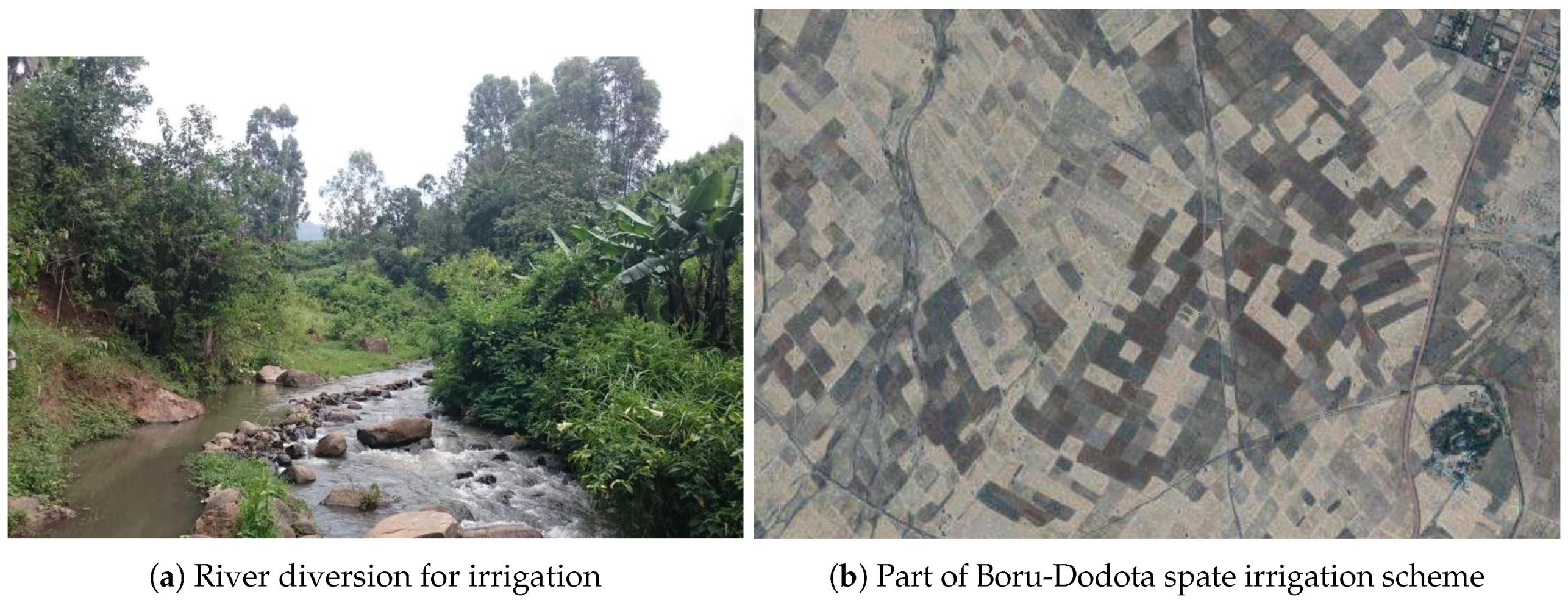
  50. Steenbergen, F.V.; Mehari, A.; Alemehayu, T.; Alamirew, T.; Geleta, Y. Status and potential of spate irrigation in Ethiopia. Water Resour. Manag. 2011, 25, 1899–1913. [Google Scholar] [CrossRef]
  51. Dejen, Z.A. Hydraulic and Operational Performance of Irrigation System in View of Interventions for Water Saving and Sustainability. Ph.D. Thesis, UNESCO-IHE Institute for Water Education, Delft, The Netherlands, 2014. [Google Scholar]
  52. Loveland, T.R.; Reed, B.C.; Brown, J.F.; Ohlen, D.O.; Zhu, Z.; Yang, L.; Merchant, J.W. Development of a global land cover characteristics database and IGBP DISCover from 1 km AVHRR data. Int. J. Remote Sens. 2000, 21, 1303–1330. [Google Scholar] [CrossRef] [Green Version]
  53. Demissie, A.; Abraham, C.; Haile, M.; Schultz, B. Optimum irrigation and pond operation to move away from exclusively rainfed agriculture: the Boru Dodota spate irrigation scheme, Ethiopia. Irrig. Sci. 2013, 31, 1091–1102. [Google Scholar] [CrossRef]
  54. DCP. Degree Confluence Project: Organized Sampling of the Entire World at Every 1u Latitude and 1u Longitude Intersection. 2018. Available online: http://confluence.org/ (accessed on 15 October 2018).
  55. GFSAD. Global Food Security Support Analysis Data (GFSAD) Project Validation Dataset. 2018. Available online: https://croplands.org/app/data/search (accessed on 1 August 2018).
Figure 1. Workflow of the GEOBIA approach of mapping irrigated agriculture in the Horn of Africa.
Remotesensing 11 00143 g001
Figure 2. Illustration of irrigation classification result (a) for a smallholder irrigation scheme near Koka Lake (Awash basin, Rift Valley, Ethiopia) in which the monthly maps are summed to give the frequency of irrigation events at field level for one year (min: 0, max: 11, spatial-heterogeneity threshold: 15%). A false-colour image (b) derived from the dry-season mosaic (RGB: NIR, red, green) is shown as a reference image of the area and serves as black-and-white background in (a). Center coordinates: 8 26.200 N 39 2.257 E.
Remotesensing 11 00143 g002
Figure 3. Illustration of irrigation classification results (blue: irrigated croplands, green: rainfed croplands) for a smallholder irrigation scheme near Koka Lake (Awash basin, Rift Valley, Ethiopia) highlighting differences between months and spatial-heterogeneity thresholds (ad). A false-colour image (e) derived from the dry-season mosaic (RGB: NIR, red, green) is shown as a reference image of the area and serves as black-and-white background in (ad). Center coordinates: 8 26.200 N 39 2.257 E.
Remotesensing 11 00143 g003
Figure 4. Temporal pattern of irrigated area in the Horn of Africa. Total monthly average rainfall in mm (CHIRPS, [42]) in the Horn is added with the first letter of the month used for annotation.
Remotesensing 11 00143 g004
Figure 5. Frequency of irrigation events (min: 1, max: 11) for the entire studied year (a) and dry-season months (min: 1, max: 5) running from October–November to February–March (b).
Remotesensing 11 00143 g005aRemotesensing 11 00143 g005b
Figure 6. An illustration of the segmentation result (a), which was carried out on the dry-season mosaic, and the cropland (shown in green) classification (b). A false-colour image (c) derived from the dry-season mosaic (RGB: NIR, red, green) is shown as a reference image of the area and serves as black-and-white background in (a). Center coordinates: 8 51.976 N 39 25.489 E.
Remotesensing 11 00143 g006
Figure 7. Comparison of irrigation classification result for a smallholder irrigation scheme near Koka Lake (Awash basin, Rift Valley, Ethiopia) between this study (a), in which the monthly maps are summed to give the frequency of irrigation events at field level for one year (min: 0, max: 11, spatial-heterogeneity threshold: 15%), and the IAAA at 250-m spatial resolution, in which all the different irrigated classes (blue), water-managed non-irrigated (orange) and rainfed classes (green) are generalised (b). A false-colour image (c) derived from the dry-season mosaic (RGB: NIR, red, green) is shown as a reference image of the area and serves as black-and-white background in (ab).
Remotesensing 11 00143 g007
Figure 8. A typical river diversion for irrigation purposes (photo taken by Marjolein Vogels) near Awassa, Rift Valley, Ethiopia (a). Google Earth Imagery (b) of a part of the Boru-Dodota spate irrigation scheme (described in [53]) depicting one of the main canals on the far right running from North to South (center coordinates: 8 12.661 N 39 21.935 E). Spate irrigation systems are only active during the rainy seasons and no cultivation occurs during the dry season. This example highlights the challenge to generate ground truth of irrigated and rainfed agriculture from visual interpretation of such imagery.
Remotesensing 11 00143 g008
Table 1. Overview of training and validation data.
Nr. of ObjectsCroplandOther LULC
Training on objects with complete NDVI time series527517,473
Validation on objects with complete NDVI time series13194368
Validation on objects with incomplete NDVI time series303812,854
Table 2. Confusion matrices (in hectares) and accuracy for the cropland classification. (A) confusion matrix on all validation data (complete and incomplete NDVI time series). (B) confusion matrix on validation data with complete NDVI time series. (C) confusion matrix on validation data with incomplete NDVI time series and uses in one or more months interpolated NDVI. Abbreviations: acc. is accuracy, coef. is coefficient.
(A) All Validation DataObserved
PredictedCroplandOther LULCUser’s acc. (%)
Cropland4927.741426.6178
Other LULC1885.284,945.2498
Producer’s acc. (%)7298
Overall acc. (%)96
Kappa coef.0.73
PredictedCroplandOther LULCUser’s acc. (%)
Cropland2650.16216.1992
Other LULC502.9266,120.0499
Producer’s acc. (%)84100
Overall acc. (%)99
Kappa coef.0.88
(C) Validation Data Incomplete NDVI Time SeriesObserved
PredictedCroplandOther LULCUser’s acc. (%)
Cropland2277.581210.4265
Other LULC1382.2818,825.293
Producer’s acc. (%)6294
Overall acc. (%)89
Kappa coef.0.57
Table 3. Comparison of cropland and irrigated-cropland estimates for the Horn of Africa from this study (for the different spatial-heterogeneity thresholds: 15%, 25%, 35%) with other available products. The results of the classification of monthly irrigated agriculture were aggregated into different categories to facilitate comparison with available products without a temporal specification. Firstly, the total area of cropland where at least one irrigation event was observed is given (irrigated cropland all). This category is split into two parts (low and high frequency of irrigation events) to indicate the area that experienced only one or two irrigation events and the area that experienced three or more irrigation events. These three categories are specified for the entire year and the dry season (October–November to February–March). Some products do not exist, which are denoted with ‘-’. Some products were unavailable (not open source), which are denoted with ‘not available’. Abbreviations: GFSAD30AFCE is global food security support analysis data [26], GLC30 is Global land cover mapping at 30 m resolution [43], GFSAD250 is global food security support-analysis data [44], IAAA is Irrigated Area Map Asia (2000–2010) and Africa (2010) [19], Globcover is Globcover 2009 [45], GRIPC is Global rain-fed, irrigated, and paddy croplands [46], GFSAD1000 (GIAM) is Global Irrigated Area Map [21,47], GMIA is Global Map of Irrigation Area’s [20], AQUASTAT is FAO’s global water information system [48].
(Irrigated) Cropland
Products
Spatial
Resolution
(m)
Cropland
(Mha)
Cropland as
Percentage of
Horn of
Africa (%)
Irrigated Cropland (Mha)Irrigated Cropland
(All) as Percentage
of Cropland Area
in the Horn
of Africa (%)
all1–23+
This study entire year 15%1041.6716.7737.1322.5714.5689.1
This study entire year 25%1041.6716.7732.8724.448.4378.88
This study entire year 35%1041.6716.7727.9623.134.8367.1
This study dry season 15%1041.6716.7723.7221.572.1556.92
This study dry season 25%1041.6716.7720.7519.221.5349.8
This study dry season 35%1041.6716.7717.6716.621.0642.41
GFSAD30AFCE3037.7115.17----
GLC303032.212.96----
GFSAD25025031.3912.63not available--not available
IAAA25050.9420.58.17 (22.39)--16.04 (53.74)
Globcover 200930037.9715.270.0004--0.01
GRIPC50022.088.891.15--5.21
GFSAD1000 (GIAM)100038.2615.49.93--25.95
GMIA10,000--0.95---
AQUASTATvariable24.419.821.23 (2.33)--2.95 (9.55)
Notes: (1) GRIPC; paddy and irrigated croplands are aggregated to represent irrigated cropland, (2) Globcover; class 11 (irrigated cropland), class 14 (rainfed cropland), class 20 (50–70% cropland mosaic, area multiplied by 0.625), class 30 (20–50% cropland mosaic, area multiplied by 0.375) are aggregated to represent cropland, (3) AQUASTAT; irrigated cropland is here expressed by area equipped for irrigation, and, the total of area equipped for irrigation and areas with other forms of agricultural water management, such as non-equipped flood recession cropping area and non-equipped cultivated wetlands and inland valley bottoms (parentheses), (4) IAAA; irrigated cropland is here expressed by the category of irrigated crops, and, the total of irrigated crops and water-managed non-irrigated crops, e.g., various cultivation practices which make use of the available soil moisture such as flood plains, valley bottoms, short-term crops using the remaining moisture after an initial rainfed crop, etc. (parentheses).

