Understanding Lateral Marsh Edge Erosion with Terrestrial Laser Scanning (TLS)

Abstract
1. Introduction
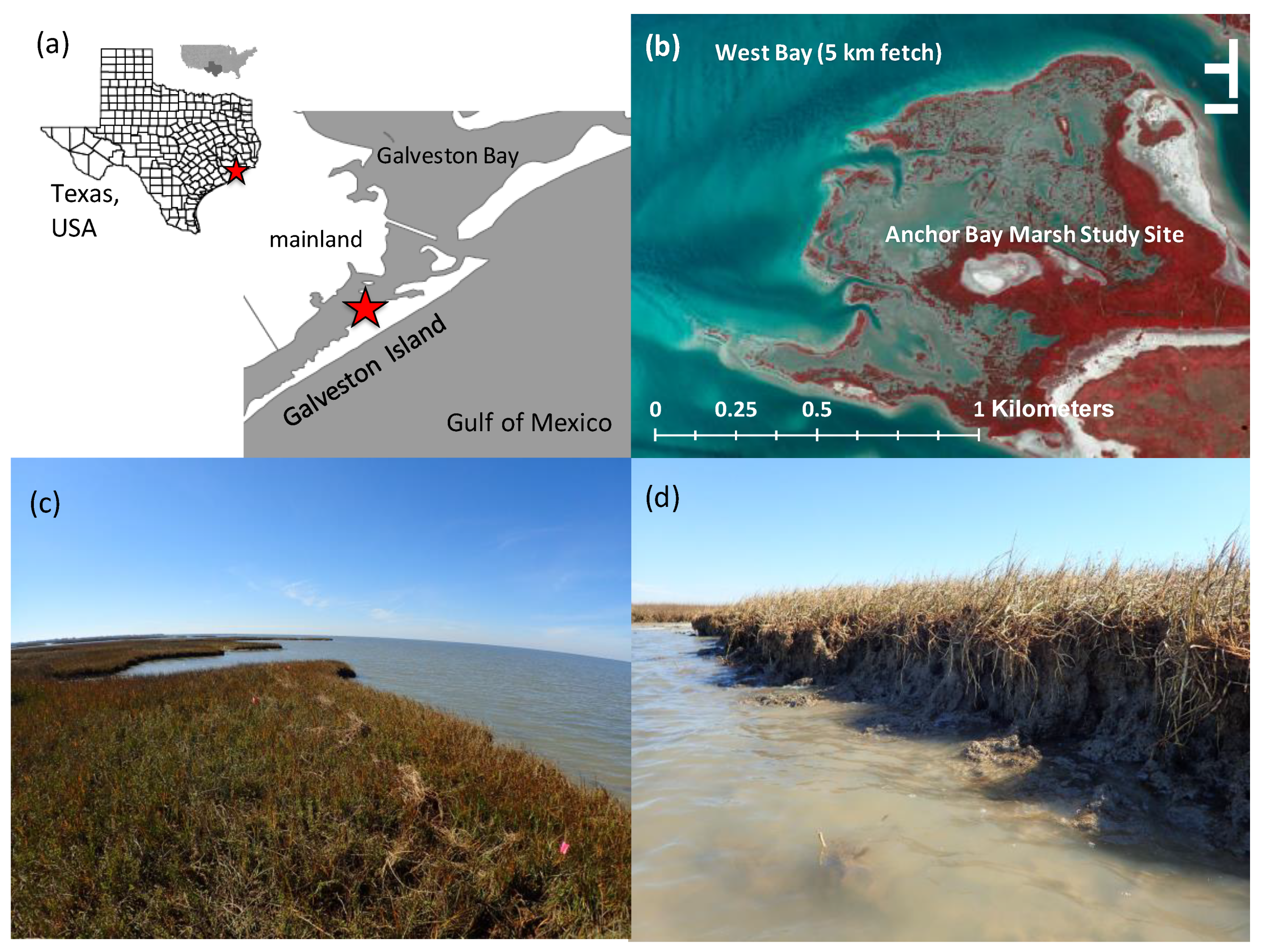
2. Methods
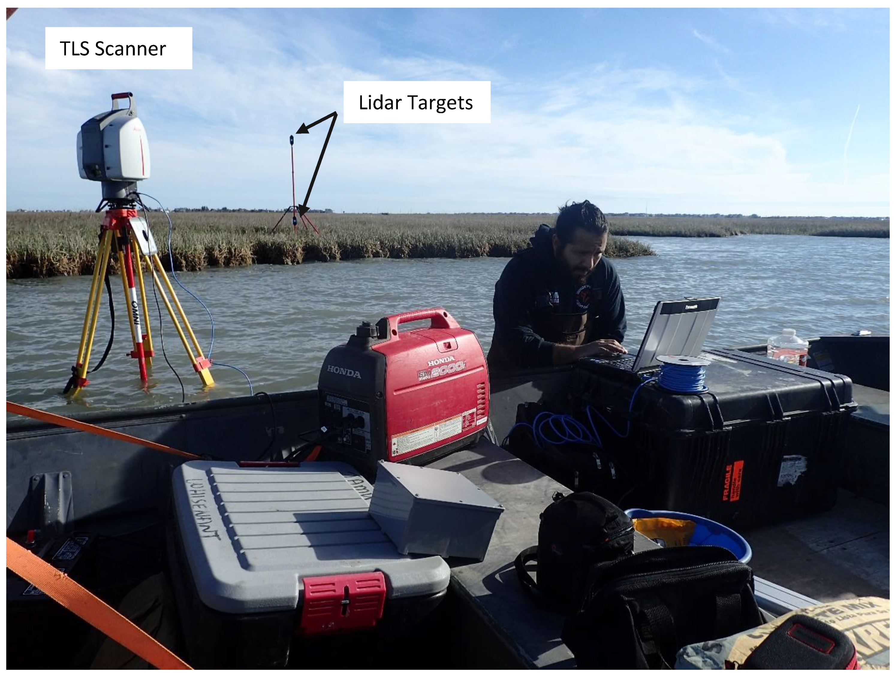
2.1. Terrestrial Laser Scanning of Erosion
2.2. Voxel Analysis: Correlating Roots with Erosion
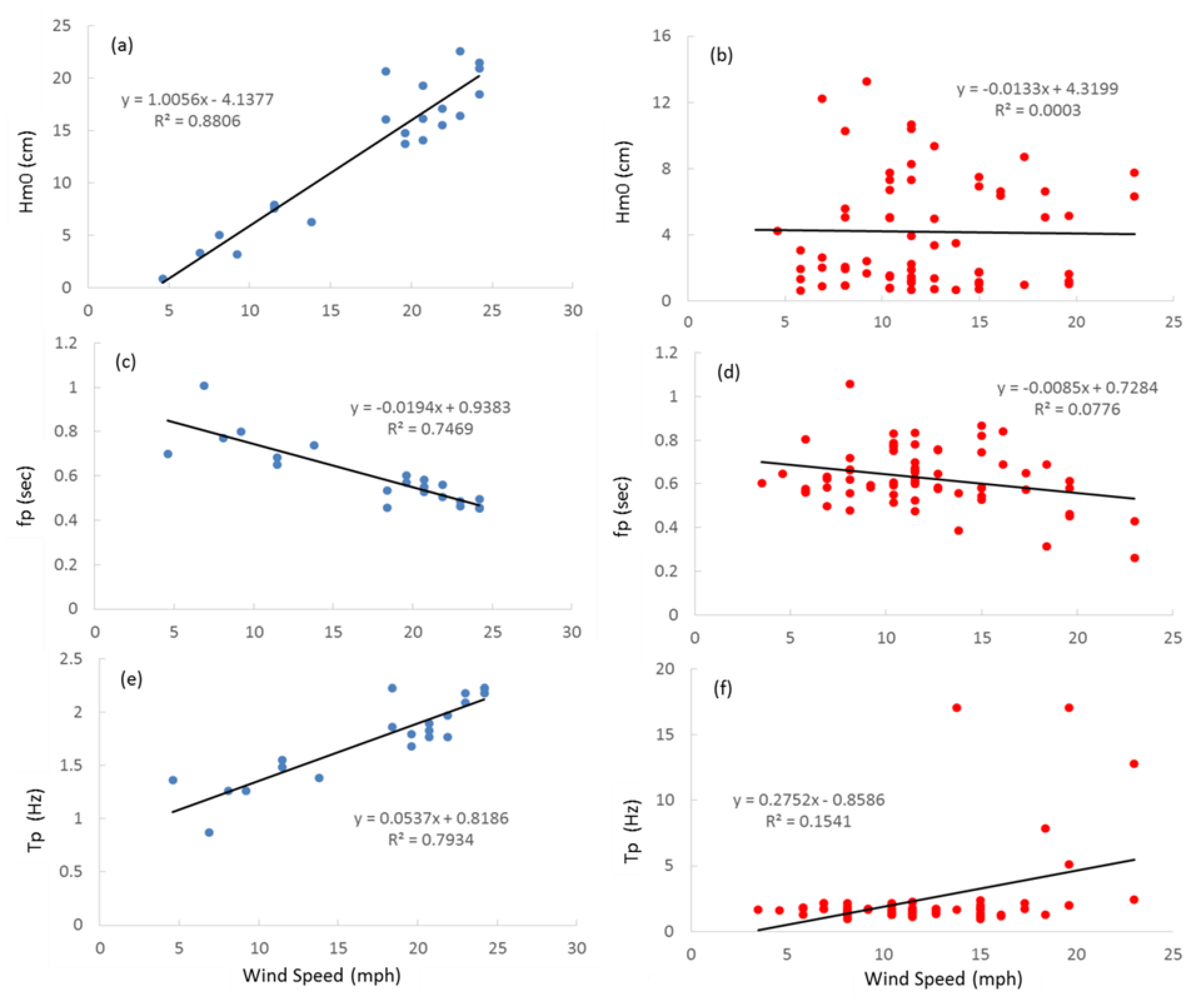
2.3. Correlating Incident Waves with Erosion
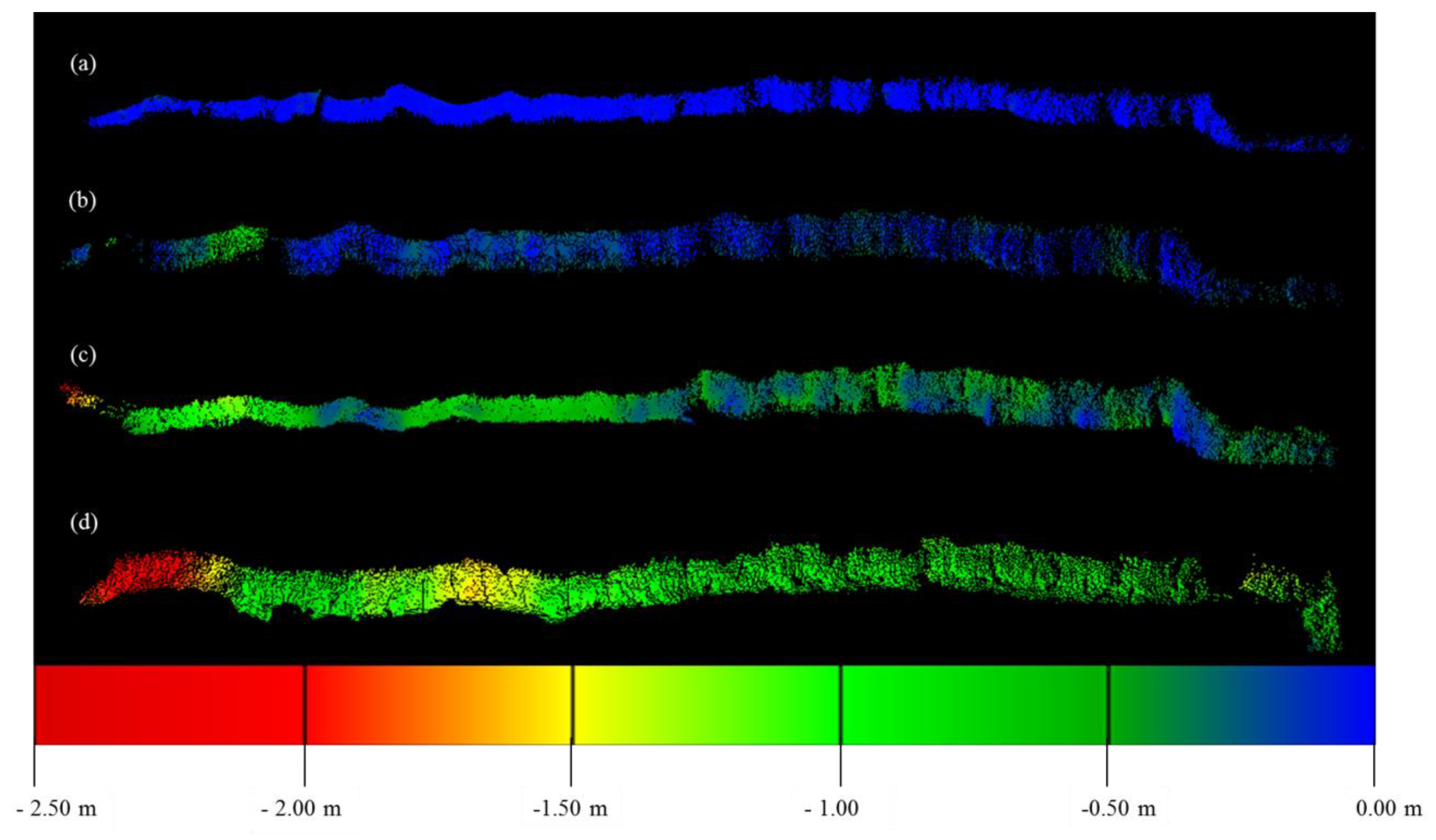
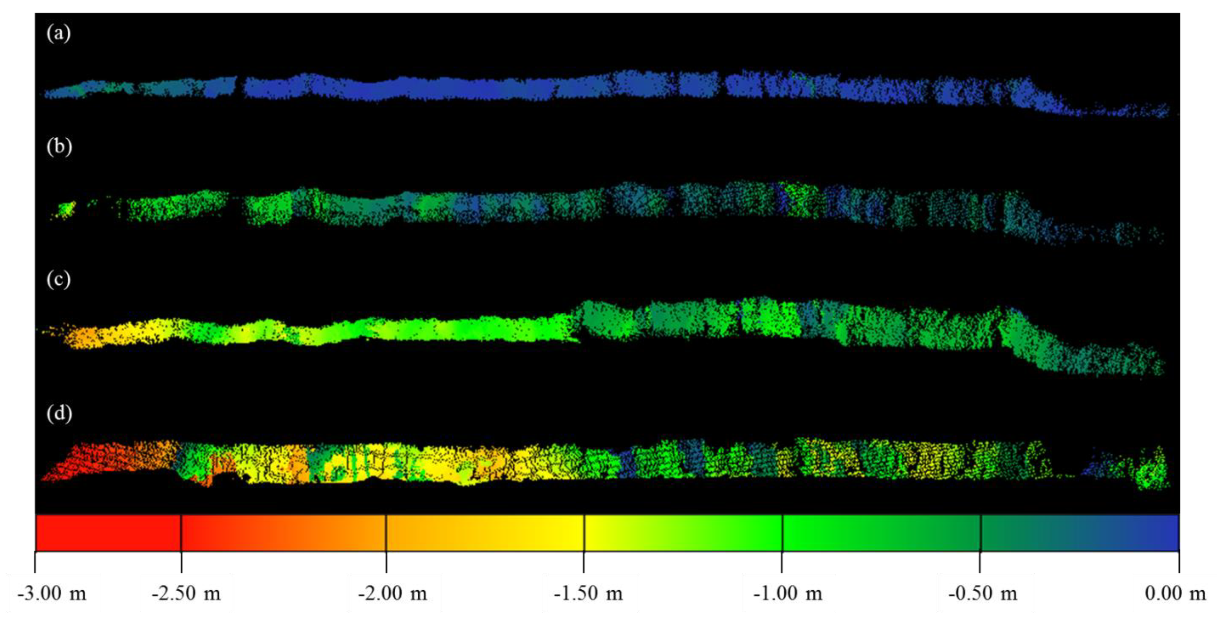
3. Results
4. Discussion
Lessons Learned
5. Conclusions
- Conducting measurements at the lowest possible tide;
- Conducting measurements at mid-day or indoors if the scanner photography will be used for imagery classification of roots;
- Developing custom packages to group point data within voxels for further analysis;
- Scanning at 1 mm point density or finer to better detect fine roots;
- Filtering out roots from point clouds to avoid miscalculating erosion/accretion;
- Utilizing a custom tripod mount, and USGS benchmark methods, for safely mounting the TLS in the aqueous and soft-sediment of the salt marsh environment.
Author Contributions
Funding
Acknowledgments
Conflicts of Interest
References
- Li, X.; Nicoletta, L.; Andrew, J.P. Wave-Driven Sediment Resuspension and Salt Marsh Frontal Erosion Alter the Export of Sediments from Macro-Tidal Estuaries. AMST 2019, 325, 17–28. [Google Scholar] [CrossRef]
- Fagherazzi, S.; Wiberg, P.L. Importance of wind conditions, fetch, and water levels on wave-generated shear stresses in shallow intertidal basins. J. Geophys. Res. Earth Surf. 2009, 114, F03022. [Google Scholar] [CrossRef]
- Leonardi, N.; Ganju, N.K.; Fagherazzi, S. A linear relationship between wave power and erosion determines salt-marsh resilience to violent storms and hurricanes. Proc. Natl. Acad. Sci. USA 2016, 113, 64–68. [Google Scholar] [CrossRef] [PubMed]
- Marani, M.; D’Alpaos, A.D.; Lanzoni, S.; Santalucia, M. Understanding and predicting wave erosion of marsh edges. Geophys. Res. Lett. 2011, 38. [Google Scholar] [CrossRef]
- Schwimmer, R. Rates and processes of marsh shoreline erosion in Rehoboth Bay, Delaware, U.S.A. J. Coast. Res. 2001, 17, 672–683. [Google Scholar]
- Coops, H.; Geilen, N.; Verhij, H.J.; Boeters, R.; van der Velde, G. Interactions between waves, bank erosion and emergent vegetation: An experimental study in a wave tank. Aquat. Bot. 1996, 53, 187–198. [Google Scholar] [CrossRef]
- Feagin, R.A.; Lozada-Bernard, S.M.; Ravens, T.; Möller, I.; Yeager, K.M.; Baird, A.H. Does vegetation prevent wave erosion of salt marsh edges? Proc. Natl. Acad. Sci. USA 2009, 106, 10109–10113. [Google Scholar] [CrossRef] [PubMed]
- Lo, V.; Bouma, T.; Van Belzen, J.; Van Colen, C.; Airoldi, L. Interactive effects of vegetation and sediment properties on erosion of salt marshes in the Northern Adriatic Sea. Mar. Environ. Res. 2017, 131, 32–42. [Google Scholar] [CrossRef] [PubMed]
- Temmerman, S.; Bouma, T.J.; van de Koppel, J.; van der Wal, D.; de Vries, M.B.; Herman, P.M.J. Vegetation causes channel erosion in a tidal landscape. J. Geol. 2007, 35, 631–634. [Google Scholar] [CrossRef]
- Gabet, E.J. Lateral migration and bank erosion in a saltmarsh tidal channel in San Francisco Bay, California. Estuaries 1998, 21, 745–753. [Google Scholar] [CrossRef]
- Collins, B.D.; Sitar, N. Processes of coastal bluff erosion in weakly lithified soils, Pacifica, California, USA. J. Geol. 2008, 97, 483–501. [Google Scholar]
- Farris, A.S.; Defne, Z.; Ganju, N.K. Identifying Slat Marsh Shorelines from Remotely Sensed Elevation Data and Imagery. Remote Sens. 2019, 11, 1795. [Google Scholar] [CrossRef]
- Turner, R.E.; McClenachan, G.; Tweel, A.W. Island in the oil: Quantifying salt marsh shoreline erosion after the deepwater horizon oiling. Mar. Pollut. Bull. 2016, 1, 316–323. [Google Scholar] [CrossRef] [PubMed]
- Young, A.P.; Olson, M.; Driscoll, N.; Flick, R.E.; Gutierrez, R.; Guza, R.T.; Johnstone, E.; Kuester, F. Comparison of Airborne and Terrestrial Lidar and Estimates of Seacliff Erosion in Southern California. Photogramm. Remote Sens. 2010, 76, 421–427. [Google Scholar] [CrossRef]
- Guarnieri, A.; Vettore, A.; Pirotti, F.; Menenti, M.; Marani, M. Retrieval of small-relief marsh morphology from terrestrial laser scanner, optimal spatial filtering, and laser return intensity. J. Geol. 2009, 113, 12–20. [Google Scholar] [CrossRef]
- Hoffmeister, D.; Tilly, N.; Curdt, C.; Aasen, H.; Ntageretzis, K.; Hadler, H.; Willershauser, T.; Vott, A.; Bareth, G. Terrestrial laser scanning for coastal geomorphologic research in Western Greece. ISPRS J. Photogramm. Remote Sens. 2012, 39, 511–516. [Google Scholar] [CrossRef]
- Silva dos Santos, A.L.; Amaro, V.E.; Santos, M.S.T. Terrestrial laser scanner applied to monitoring beach morphological changes in a high energy coastal zone in Northeast Brazil. In Proceedings of the 7th International Terrestrial Laser Scanner User Meeting, Rome, Italy, 12–13 June 2014. [Google Scholar]
- Feagin, R.A.; Williams, A.M.; Popescu, S.; Stukey, J.; Washington-Allen, R.A. The use of terrestrial laser scanning (TLS) in dune ecosystems: The lessons learned. J. Coast. Res. 2014, 30, 111–119. [Google Scholar] [CrossRef]
- Schubert, J.E.; Gallien, T.W.; Majd, M.S.; Sanders, B.F. Terrestrial laser scanning of anthropogenic beach berm erosion and overtopping. J. Coast. Res. 2015, 31, 47–60. [Google Scholar] [CrossRef]
- Nguyen, C.; Starek, M.; Tissot, P.; Gibeaut, J. Multi-scale voxel segmentation for terrestrial lidar data within marshes. In Proceedings of the American Geophysical Union Fall Meeting, San Francisco, CA, USA, 12–16 December 2016. [Google Scholar]
- Nguyen, C.; Starek, M.; Tissot, P.; Gibeaut, J. Unsupervised Clustering Method of Complex Reduction of Terrestrial Lidar Data in Marshes. Remote Sens. 2018, 10, 133. [Google Scholar] [CrossRef]
- Cahoon, D.R.; Hensel, P.; Rybczyk, J.; McKee, K.L.; Proffitt, C.E.; Perez, B.C. Mass tree mortality leads to mangrove peat collapse at Bay Islands, Honduras after Hurricane Mitch. J. Ecol. 2003, 91, 1093–1105. [Google Scholar] [CrossRef]
- Cloud Compare. Available online: http://www.cloudcompare.org/ (accessed on 19 September 2015).
- Lague, D.; Brodu, N.; Leroux, J. Accurate 3D comparison of complex topography with terrestrial laser scanner: Application to the Rangitikei canyon (N-Z). ISPRS J. Photogramm. Remote Sens. 2013, 82, 10–26. [Google Scholar] [CrossRef]
- Barnhart, T.; Crosby, B. Comparing two methods of surface change detection on an evolving thermokarst using high-temporal-frequency terrestrial laser scanning, Selawik River, Alaska. Remote Sens. 2013, 5, 2813–2837. [Google Scholar] [CrossRef]
- R Core Team, R: A Language and Environment for Statistical Computing, Vienna, Austria. Available online: https://www.R-project.org/ (accessed on 19 September-2015).
- Mori, N.; Suzuki, T.; Kakuno, S. Noise of acoustic Doppler velocimeter data in bubbly flows. J. Eng. Mech. 2007, 133, 122–125. [Google Scholar] [CrossRef]
- Karimpour, A. OCEANLYZ, Ocean Wave Analyzing Toolbox, user manual. Available online: http://www.arashkarimpour.com/oceanlyz.html (accessed on 19 September 2015).
- Lecinge, B.; Delagrange, S.; Messier, C. CloudCompare, version 2.6.1 14; VoxR: Metrics Extraction of Trees: Hannover Germany, 2018. [Google Scholar]


| Was a Commission Error Made and What Percent of the Time did It Happen? | ||||
|---|---|---|---|---|
| 55–80 Red Values Band 1 | 55–80 Green Values Band 2 | 55–80 Blue Values Band 3 | 55–80 RGB Values All Bands | |
| % Yes | % Yes | % Yes | % Yes | |
| Roots | 37.25% | 38.10% | 16.68% | 14.50% |
| Soil | 5.94% | 5.94% | 2.49% | 2.49% |
| Flare Soil | 14.78% | 27.83% | 49.57% | 0.00% |
| Flare Roots | 0.00% | 0.00% | 0.23% | 0.00% |
| M3C2 Distance (m) | C2C Absolute Distance (m) | C2C Absolute Distance X (m) | C2C Absolute Distance Y (m) | C2C Absolute Distance Z (m) | |
|---|---|---|---|---|---|
| Interval 1 | −0.081 | −0.025 | 0.004 | 0.004 | −0.002 |
| Interval 2 | −0.432 | −0.184 | −0.082 | −0.108 | −0.032 |
| Interval 3 | −0.903 | −0.488 | −0.251 | −0.323 | −0.064 |
| Interval 4 | −1.301 | −1.095 | −0.582 | −0.790 | −0.160 |
© 2019 by the authors. Licensee MDPI, Basel, Switzerland. This article is an open access article distributed under the terms and conditions of the Creative Commons Attribution (CC BY) license (http://creativecommons.org/licenses/by/4.0/).
Share and Cite
Huff, T.P.; Feagin, R.A.; Delgado, A., Jr. Understanding Lateral Marsh Edge Erosion with Terrestrial Laser Scanning (TLS). Remote Sens. 2019, 11, 2208. https://doi.org/10.3390/rs11192208
Huff TP, Feagin RA, Delgado A Jr. Understanding Lateral Marsh Edge Erosion with Terrestrial Laser Scanning (TLS). Remote Sensing. 2019; 11(19):2208. https://doi.org/10.3390/rs11192208
Chicago/Turabian StyleHuff, Thomas P., Rusty A. Feagin, and Arturo Delgado, Jr. 2019. "Understanding Lateral Marsh Edge Erosion with Terrestrial Laser Scanning (TLS)" Remote Sensing 11, no. 19: 2208. https://doi.org/10.3390/rs11192208
APA StyleHuff, T. P., Feagin, R. A., & Delgado, A., Jr. (2019). Understanding Lateral Marsh Edge Erosion with Terrestrial Laser Scanning (TLS). Remote Sensing, 11(19), 2208. https://doi.org/10.3390/rs11192208