Twenty Years of ASTER Contributions to Lithologic Mapping and Mineral Exploration


Abstract
:
1. Introduction
2. Early Geologic Applications of Spaceborne Instruments
3. ASTER History
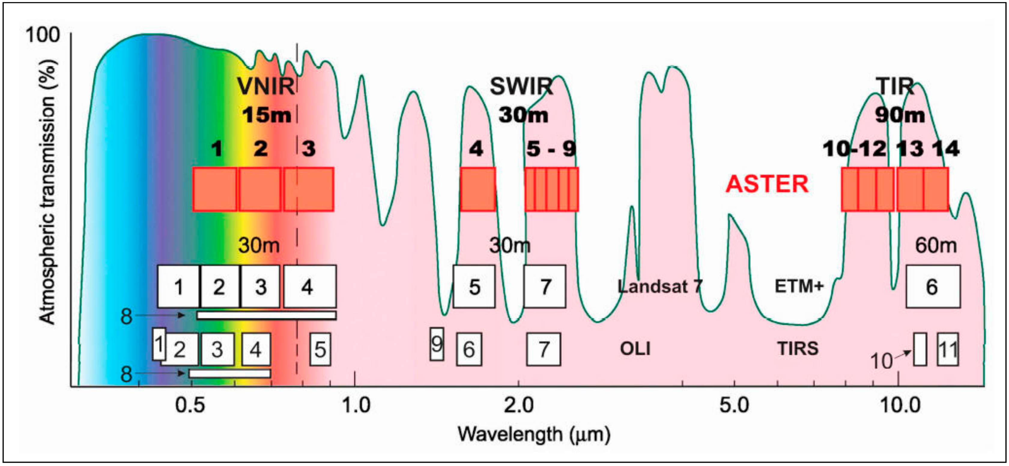
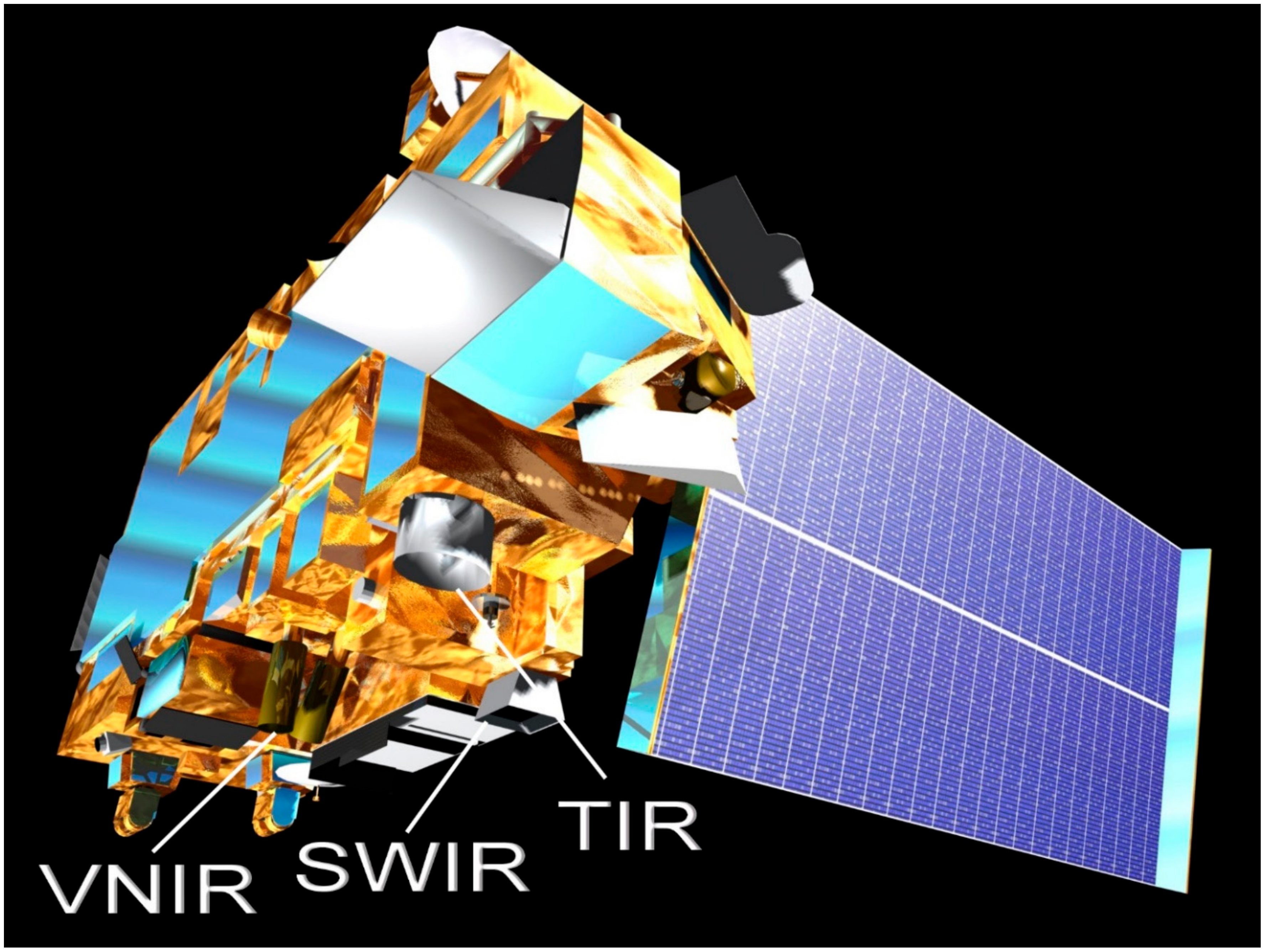
4. ASTER Instrument
- increased number of SWIR bands to six to improve mapping of surface composition;
- increased number of TIR bands to five to derive accurate surface temperature and emissivity measurements [22];
- improved radiometric accuracy and resolution [23].
- increased base-to-height (b/h) ratio of the stereo data, from 0.3 to 0.6, to improve surface elevation determination
5. Lithologic Mapping with ASTER Data
5.1. Mapping Using Only ASTER Data
5.2. Lithologic Mapping with ASTER and Other Remote Sensing Data
6. Mineral Exploration with ASTER Data
6.1. Technique Development for Alteration Mapping
6.2. General Alteration Mapping
6.3. Alteration Mapping with ASTER Data and Other Data Sources
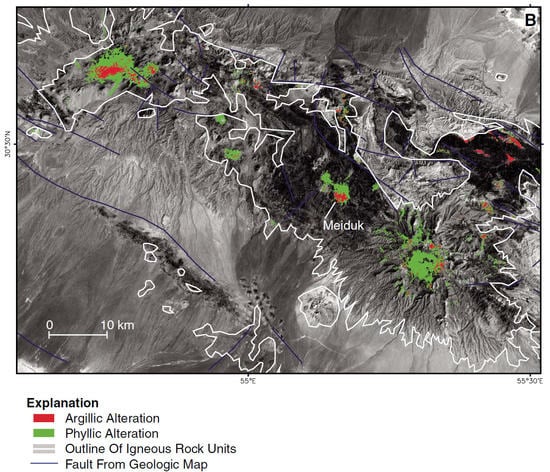
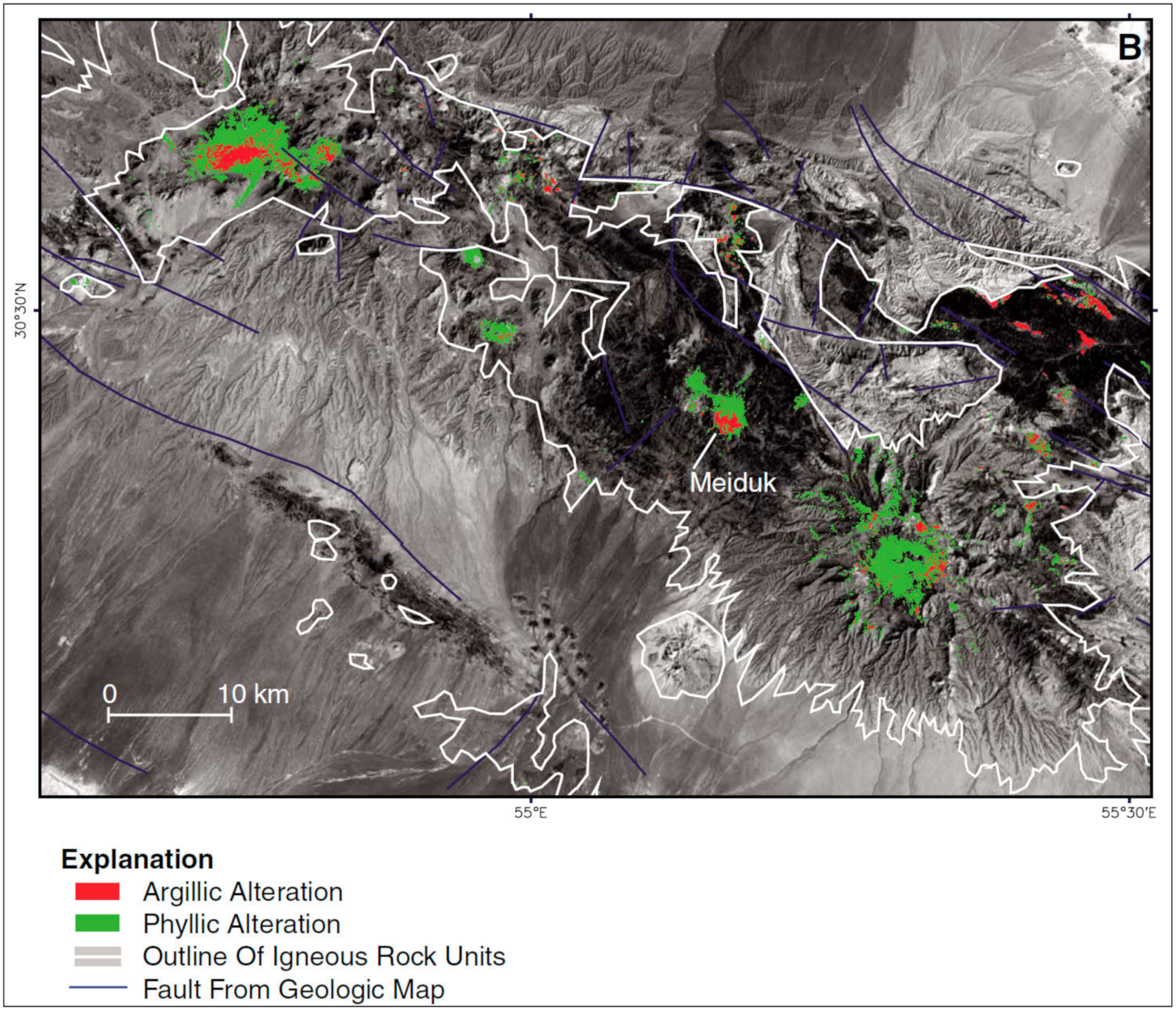
6.4. ASTER Data Applied to Porphyry Copper Exploration
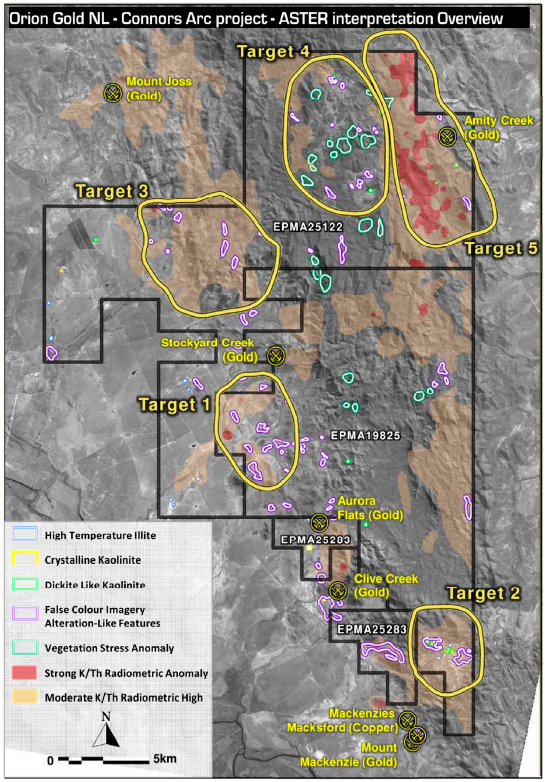
6.5. ASTER Data Applied to Gold Exploration
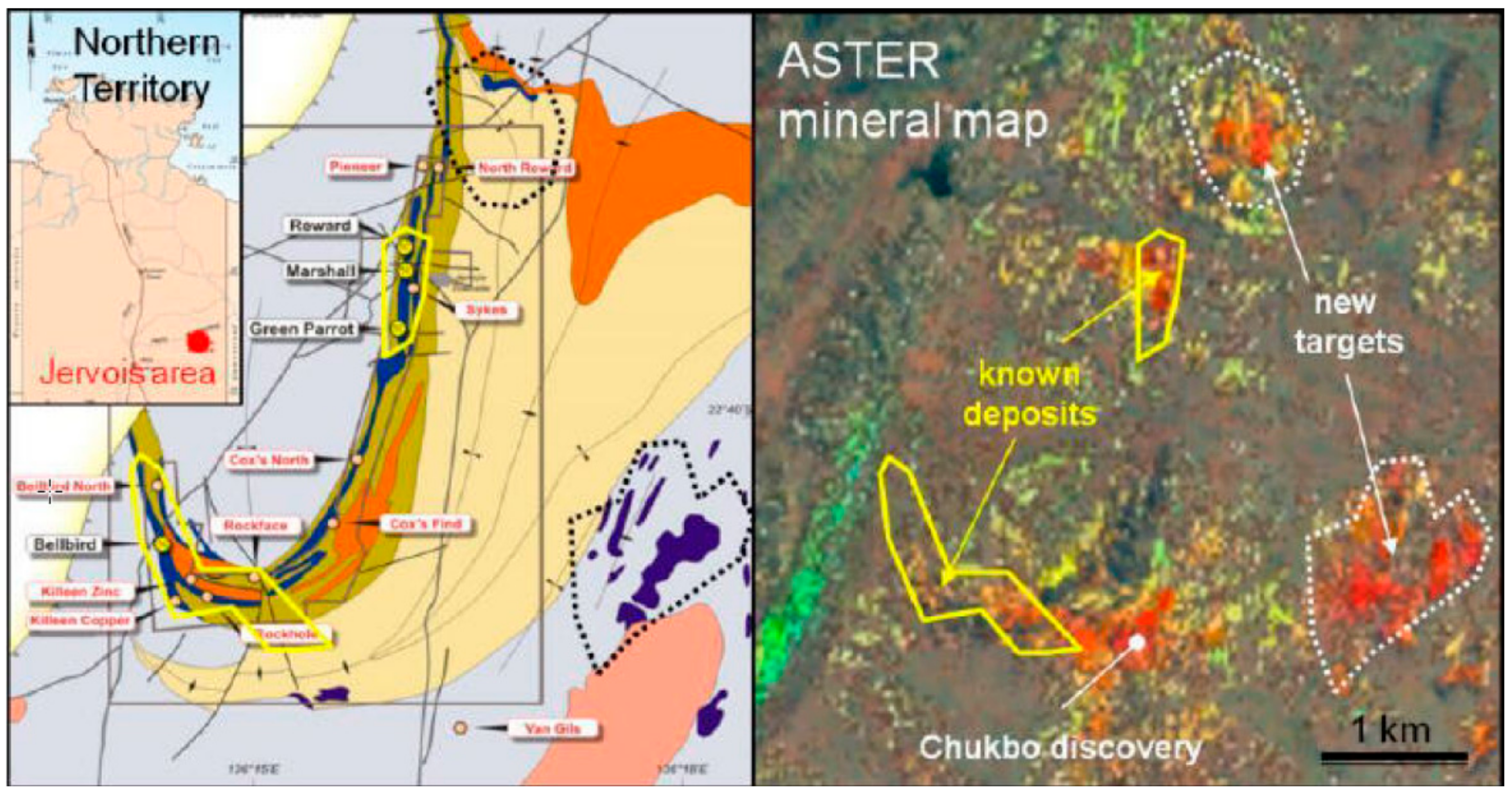
6.6. ASTER Data Applied to Exploration for Other Minerals
7. Discussion and Conclusions
Author Contributions
Funding
Acknowledgments
Conflicts of Interest
Acronyms
| AIST | National Institute of Advanced Industrial Science and Technology |
| ALI | Advanced Land Imager |
| ASTER | Advanced Spaceborne Thermal Emission and Reflection Radiometer |
| CSIRO | Commonwealth Scientific and Industrial Research Organisation |
| EO-1 | Earth Observer |
| EOS | Earth Observing System |
| ERTS | Earth Resources Technology Satellite |
| GDEM | Global digital elevation model |
| HRV | High resolution visible |
| IRS | Indian Remote Sensing |
| ITIR | Intermediate Thermal Infrared Radiometer |
| JERS | Japan Earth Resources Satellite |
| LPDAAC | Land Processes Distributed Active Archive Center |
| METI | Ministry of Economy, Trade and Industry |
| MITI | Ministry of International Trade and Industry |
| MSS | Multispectral scanner |
| NASA | National Aeronautics and Space Administration |
| NASDA | National Space Development Agency |
| OLI | Operational Land Imager |
| OPS | Optical sensor |
| PALSAR | Phased Array type L-band Synthetic Aperture Radar |
| SAC-C | Scientific Application Satellite-C |
| SPOT | Satellite pour l’Observation de la Terre |
| STA | Science and Technology Agency |
| SWIR | Short wave infrared |
| TIGER | Thermal Infrared Ground Emission Radiometer |
| TIR | Thermal infrared |
| TM | Thematic Mapper |
| VNIR | Visible and near infrared |
Appendix A. ASTER Operations
Appendix A.1. Data Acquisition

Appendix A.2. Data Products
Appendix A.3. Data Archiving and Distribution
Appendix B. Spectral Indices
Appendix B.1. TIR Spectral Indices
- CI = Carbonate index = B13/B14, where B13 is the value of radiance-at-sensor of ASTER TIR band 13; CI is high for calcite and dolomite
- QI = Quartz Index = (B11 × B11)/(B10 + B12)
- MI = Mafic Index = (B12 × B143)/B134
Appendix B.2. Logical Operators
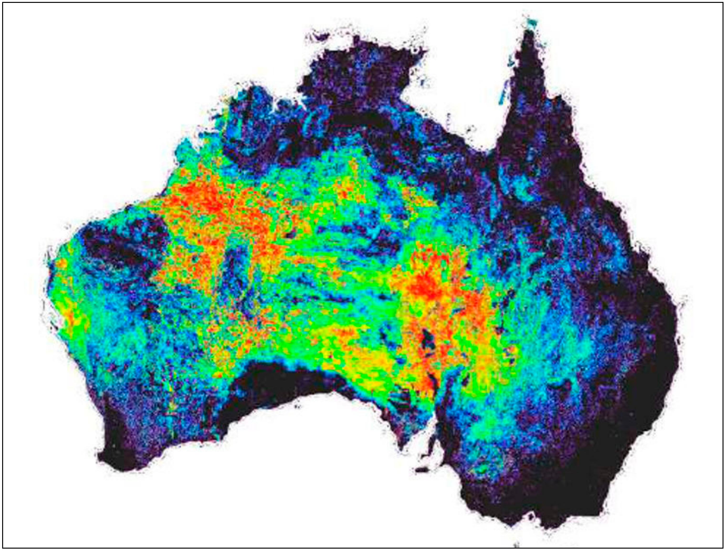
Appendix B.3. Australian Geoscience Maps
- Algorithm = (B6+B9)/(B7+B8)
- Masks = green vegetation <1.4 and cloud, water, shadow and sun glint
- Stretch = linear 1.05–1.2
References
- Abrams, M.; Tsu, H.; Hulley, G.; Iwao, K.; Pieri, D.; Cudahy, T.; Kargel, J. The Advanced Spaceborne Thermal Emission and Reflection Radiometer (ASTER) after Fifteen Years: Review of Global Data Product. Int. J. Appl. Earth Obs. Geoinform. 2015, 38, 292–301. [Google Scholar] [CrossRef]
- Goetz, A.; Billingsley, F.; Elston, D.; Lucchitta, I.; Shoemaker, E.; Abrams, M.; Gillespie, A.; Squires, R. Applications of ERTS Images and Image Processing to Regional Problems and Geologic Mapping in Northern Arizona; NASA/JPL Technical Reports 32-1597; NASA: Pasadena, CA, USA, 1975.
- Baker, R. Landsat Data: A new perspective for geology. Photogramm. Eng. Remote Sens. 1975, 41, 1233–1239. [Google Scholar]
- Sabins, F. Remote Sensing: Principles and Interpretation; W. H. Freeman: San Francisco, CA, USA, 1975; p. 426. [Google Scholar]
- Siegal, B.; Gillespie, A. (Eds.) Remote Sensing in Geology; Wiley: New York, NY, USA, 1980; p. 702. [Google Scholar]
- Landsat Science. Available online: https://landsat.gsfc.nasa.gov/the-thematic-mapper/ (accessed on 29 January 2019).
- Abrams, M.; Ashley, R.; Rowan, L.; Goetz, A.; Kahle, A. Mapping hydrothermal alteration in the Cuprite mining district, Nev., using aircraft scanner imagery for the 0.46–2.36 micron spectral region. Geology 1977, 5, 713–718. [Google Scholar] [CrossRef]
- Abrams, M. The Joint NASA Geosat Test Case Project: Final Report; American Association of Petroleum Geologists: Tulsa, OK, USA, 1985; 3 volumes. [Google Scholar]
- Abdelhamid, G.; Rabba, I. An investigation of mineralized zones revealed during geologic mapping, Jabal-Hamra-Faddan Wadi area, Jordan, using Landsat-TM data. Int. J. Remote Sens. 1994, 15, 1495–1506. [Google Scholar] [CrossRef]
- Rothery, D.; Abrams, M. Improved discrimination of rock units using Landsat Thematic Mapper imagery of the Oman Ophiolite. J. Geol. Soc. Lond. 1987, 144, 587–597. [Google Scholar] [CrossRef]
- Van Der Meer, F.; Vazquez-Torres, M.; Van Dijk, P. Spectral characterization of ophiolite lithologies in the Troodos Ophiolite complex of Cyprus and its potential in prospecting for massive sulfide deposits. Int. J. Remote Sens. 1997, 18, 1245–1257. [Google Scholar] [CrossRef]
- Elrakaiby, M. The use of enhanced Landsat-TM image in the characterization of uraniferous granitic rocks I the central eastern desert of Egypt. Int. J. Remote Sens. 1995, 16, 1063–1074. [Google Scholar] [CrossRef]
- Qari, M. Application of Landsat TM data to geological studies, Al-Khabt area, southern Arabian shield. Photogramm. Eng. Remote Sens. 1991, 57, 421–429. [Google Scholar]
- Sabins, F. Remote sensing for mineral exploration. Ore Geol. Rev. 1999, 14, 157–183. [Google Scholar] [CrossRef]
- Almeida, T.; Filho, C.; Juliani, C.; Branco, F. Application of Remote Sensing to Geobotany to Detect Hydrothermal Alteration Facies in Epithermal High-Sulfidation Gold Deposits in the Amazon Region. Rev. Econ. Geol. 2006, 16, 135–142. [Google Scholar]
- eoPortal Directory. Available online: https://earth.esa.int/web/eoportal/satellite-missions/j/jers-1 (accessed on 30 January 2019).
- DeSouza, C.; Drury, S. Evaluation of JERS-1 (FUYO-1) OPS and Landsat TM images for mapping of gneissic rocks in arid areas. Int. J. Remote Sens. 1998, 19, 3569–3594. [Google Scholar] [CrossRef]
- Salomonson, V.; Abrams, M.; Kahle, A.; Barnes, W.; Xiong, X.; Yamaguchi, Y. Evolution of NASA’s earth Observing System and development of the Moderate Resolution Imaging Spectrometer and the Advanced Spaceborne Thermal Emission and Reflection radiometer instruments. In Land Remote Sensing and Global Environmental Change; Ramachandran, R., Justice, C., Abrams, M., Eds.; Springer: New York, NY, USA, 2011; Chapter 1; pp. 3–34. [Google Scholar]
- Yamaguchi, Y.; Tsu, H.; Fujisada, H. Scientific basis of ASTER instrument design. Proc. SPIE 1998, 1939, 150–160. [Google Scholar]
- Plafcan, D. Technoscientific Diplomacy: The practice of international policies in the ASTER collaboration. In Land Remote Sensing and Global Environmental Change; Ramachandran, R., Justice, C., Abrams, M., Eds.; Springer: New York, NY, USA, 2011; Chapter 4; pp. 483–508. [Google Scholar]
- Yamaguchi, Y.; Sato, I.; Tsu, H. ITIR design concept and science mission. In The Use of EOS for Studies of Atmospheric Physics; Gille, J.C., Visconti, G., Eds.; Elsevier: New York, NY, USA, 1992; pp. 229–310. [Google Scholar]
- Yamaguchi, Y.; Kahle, A.; Tsu, H.; Kawakami, T.; Pniel, M. Overview of Advanced Spaceborne Thermal Emission and Reflection Radiometer (ASTER). IEEE Trans. Geosci. Remote Sens. 1998, 36, 1062–1071. [Google Scholar] [CrossRef] [Green Version]
- Fujisada, H. Terra ASTER Instrument Design and Geometry. In Land Remote Sensing and Global Environmental Change; Ramachandran, R., Justice, C., Abrams, M., Eds.; Springer: New York, NY, USA, 2011; Chapter 4; pp. 59–82. [Google Scholar]
- Fujisada, H.; Bailey, G.; Kelly, G.; Hara, S.; Abrams, M. ASTER DEM Performance. IEEE Trans. Geosci. Remote Sens. 2005, 43, 2702–2714. [Google Scholar] [CrossRef]
- Balick, L.; Gillespie, A.; French, A.; Danilina, I.; Allard, J.P.; Mushkin, A. Longwave thermal infrared spectral variability in individual rocks. IEEE Geosci. Remote Sens. Lett. 2009, 6, 52–56. [Google Scholar] [CrossRef]
- Rowan, L.; Mars, J. Lithologic mapping in the Mountain Pass, California area using ASTER data. Remote Sens. Environ. 2003, 84, 350–366. [Google Scholar] [CrossRef]
- Watts, D.; Harris, N. Mapping granite and gneiss in domes along the North Himalayan antiform with ASTER SWIR band ratios. Geol. Soc. Am. Bull. 2005, 117, 879–886. [Google Scholar] [CrossRef]
- Yamaguchi, Y.; Naito, C. Spectral indices for lithologic discrimination and mapping by using the ASTER SWIR bands. Int. J. Remote Sens. 2003, 24, 4311–4323. [Google Scholar] [CrossRef]
- Byrnes, J.; Ramsey, M.; Crown, D. Surface unit characterization of the Mauna Ulu flow field, Kilauea Volcano, Hawaii, using integrated field and remote sensing analyses. J. Volcanol. Geotherm. Res. 2004, 135, 169–193. [Google Scholar] [CrossRef]
- Gomez, C.; Delacourt, C.; Allemand, P.; Ledru, P.; Wackerle, R. Using ASTER remote sensing data set for geological mapping, in Namibia. Phys. Chem. Earth 2005, 30, 97–108. [Google Scholar] [CrossRef]
- Kargel, J.; Abrams, M.; Bishop, M.; Bush, A.; Hamilton, G.; Jiskoot, H.; Kaag, A.; Kieffer, H.; Lee, E.; Paul, F.; et al. Multispectral imaging contributions to global land ice measurements from space. Remote Sens. Environ. 2005, 99, 187–219. [Google Scholar] [CrossRef]
- Ninomiya, Y.; Fu, B.; Cudahy, T. Detecting lithology with Advanced Spaceborne Thermal Emission and Reflection radiometer (ASTER) multispectral thermal infrared “radiance-at-sensor” data. Remote Sens. Environ. 2005, 99, 127–139. [Google Scholar] [CrossRef]
- Hook, S.; Dmochowski, J.; Howard, K.; Rowan, L.; Karlstrom, K.; Stock, J. Mapping variations in weight percent silica measured from multispectral thermal infrared imagery; examples from the Hiller Mountains, Nevada, USA and Tres Virgenes-La Reforma, Baja California Sur, Mexico. Remote Sens. Environ. 2005, 95, 273–289. [Google Scholar] [CrossRef]
- Rowan, L.; Mars, J.; Simpson, C. Lithologic mapping of the Mordor, NT, Australia ultramafic complex by using Advanced Spaceborne Thermal Emission and Reflection Radiometer (ASTER). Remote Sens. Environ. 2005, 99, 105–126. [Google Scholar] [CrossRef]
- Hewson, R.; Cudahy, T.; Mizuhiko, S.; Ueda, K.; Mauger, A. Seamless geological map generation using ASTER in the Broken Hill-Curnamona province of Australia. Remote Sens. Environ. 2005, 99, 159–172. [Google Scholar] [CrossRef]
- Qiu, F.; Abdelsalam, M.; Thakkar, P. Spectral analysis of ASTER data covering part of the Neoproterozoic Allaqi-Heiani suture, Southern Egypt. J. Afr. Earth Sci. 2006, 44, 169–180. [Google Scholar] [CrossRef]
- Rajendran, S.; Hersi, O.; Al-Harthy, A.; Al-Wardi, M.; El-Ghali, M.; Al-Abri, A. Capability of Advanced Spaceborne Thermal Emission and Reflection radiometer (ASTER) on discrimination of carbonates and associated rocks and mineral identification of eastern mountain region (Saih Hatat window) of Sultanate of Oman. Carbonates Evaporates 2011, 26, 352–364. [Google Scholar]
- Rajendran, S.; Nasir, S. ASTER spectral sensitivity of carbonate rocks—Study in Sultanate of Oman. Adv. Space Res. 2014, 53, 656–673. [Google Scholar] [CrossRef]
- Guba, A.; Kumar, K.; Rao, E.; Parveen, R. An image processing approach for converting ASTER derived spectral maps for mapping Kolhan limestone, Jharkhand, Indian. Curr. Sci. 2014, 106, 40–49. [Google Scholar]
- Graettinger, A.; Ellis, M.; Skilling, I.; Reata, K.; Ramsey, M.; Lee, R.; Hughes, C.; McGarvie, D. Remote sensing and geologic mapping of glaciovolcanic deposits in the region surrounding Askja (Dyngjufjoll) volcano, Iceland. Int. J. Remote Sens. 2013, 34, 7178–7198. [Google Scholar] [CrossRef]
- Tayebi, M.; Tangestani, M.; Roosta, H. Mapping salt diapirs and salt diapir-affected areas using MLP neural network model and ASTER data. Int. J. Dig. Earth 2013, 6, 143–157. [Google Scholar] [CrossRef]
- Yajima, T.; Yamaguchi, Y. Geological mapping of the Francistown area in northeastern Botswana by surface temperature and spectral emissivity information derived from ASTER thermal infrared data. Ore Geol. Rev. 2013, 53, 134–144. [Google Scholar] [CrossRef]
- Ninomiya, Y.; Fu, B. Regional Lithological Mapping Using ASTER-TIR Data: Case Study for the Tibetan Plateau and the Surrounding Area. Geosciences 2016, 6, 39. [Google Scholar] [CrossRef]
- Ozyavas, A. Assessment of image processing techniques and ASTER SWIR data for the delineation of evaporates and carbonate outcrops along the Salt Lake Fault, Turkey. Int. J. Remote Sens. 2016, 37, 770–781. [Google Scholar] [CrossRef]
- Askari, G.; Pour, A.; Pradhan, B.; Sarfi, M.; Nazemnejad, F. Band Ratios Matrix Transformation (BRMT): A Sedimentary Lithology Mapping Approach Using ASTER Satellite Sensor. Sensors 2018, 18, 3213. [Google Scholar] [CrossRef] [PubMed]
- Hubbard, B.; Hooper, D.; Solano, F.; Mars, J. Determining mineralogical variations of aeolian deposits using thermal infrared emissivity and linear deconvolution methods. Aeolian Res. 2018, 30, 54–96. [Google Scholar] [CrossRef]
- Rajendran, S.; Nasir, S.; El-Ghali, M.; Alzebdeh, K. Spectral Signature Characterization and Remote Mapping of Oman Exotic Limestones for Industrial Rock Resource Assessment. Geosciences 2018, 8, 145. [Google Scholar] [CrossRef]
- Massironi, M.; Bertoldi, L.; Calafa, P.; Visona, D. Interpretation and processing of ASTER data for geological mapping and granitoids detection in the Saghro massif (eastern Anti-Atlas, Morocco). Geosphere 2008, 4, 736–759. [Google Scholar] [CrossRef]
- Bertoldi, L.; Massironi, M.; Visona, D.; Caros, R.; Montomoli, C.; Gubert, F.; Naletto, G.; Pelizzo, M. Mapping the Buraburi granite in the Himalaya of Western Nepal: Remote sensing analysis in a collisional belt with vegetation cover and extreme variation of topography. Rem Sens. Environ. 2011, 115, 1129–1144. [Google Scholar] [CrossRef]
- Omran, A.; Hahn, M.; Hochschild, V.; El-Reyes, A. Lithological Mapping of Dahab Basin, South Sinai, Egypt, using ASTER Data. Photogramm. Fernerkund. Geoinform. 2012, 6, 711–726. [Google Scholar] [CrossRef]
- Zheng, S.; Fu, B. Lithological mapping of granitiods in the western Junggar from ASTER SWIR-TIR multispectral data: Case study in Karamay pluton, Xinjiang. Acta Petrol. Sin. 2013, 29, 2936–2948. [Google Scholar]
- El Janati, M.; Soulaimani, A.; Admou, H.; Youbi, M.; Hafid, A.; Hefferan, K. Application of ASTER remote sensing data to geological mapping of basement domains in arid regions: A case study from the Central Anti-Atlas, Iguerda inlier, Morocco. Arab. J. Geosci. 2014, 7, 2407–2422. [Google Scholar] [CrossRef]
- Guha, A.; Kumar, K. New ASTER derived thermal indices to delineate mineralogy of different granitoids of an Archaean Craton and analysis of their potentials with reference to Ninomiya’s indices for delineating quartz and mafic minerals of granitoids—An analysis in Dharwar Craton, Indian. Ore Geol. Rev. 2016, 74, 76–87. [Google Scholar]
- Asran, A.; Emam, A.; E-Fakharani, A. Geology, structure, geochemistry and ASTER-based mapping of Neoproterozoic Gebel El-Delihimmi granites, Central Eastern Desert of Egypt. Lithos 2017, 282, 358–372. [Google Scholar] [CrossRef]
- Li, P.; Long, X.; Liu, L. Ophiolite mapping using ASTER data: A case study of Derni ophiolite complex. Acta Petrol. Sin. 2007, 23, 1175–1180. [Google Scholar]
- Huang, Z.; Zhang, X. Lithological mapping of ophiolite composition in Zedan-Luobusha, Yarlung Zangbo suture zone using Advanced Spaceborne Thermal Emission and Reflection Radiometer (ASTER) data. Acta Petrol. Sin. 2010, 26, 3589–3596. [Google Scholar]
- Tangestani, M.; Jaffari, L.; Vincent, R.; Sridhar, B. Spectral characterization and ASTER-based lithological mapping of an ophiolite complex: A case study from Neyriz ophiolite, SW Iran. Remote Sens. Environ. 2011, 115, 2243–2254. [Google Scholar] [CrossRef]
- Ozkan, M.; Celik, O.; Ozyavas, A. Lithological discrimination of accretionary complex (Sivas, northern Turkey) using novel hybrid color composites and field data. J. Afr. Earth Sci. 2018, 138, 75–85. [Google Scholar] [CrossRef]
- Deller, M.; Andrews, S. Facies discrimination in laterites using Landsat Thematic Mapper, ASTER and ALI data—Examples from Eritrea and Arabia. Int. J. Remote Sens. 2006, 27, 2389–2409. [Google Scholar] [CrossRef]
- Qari, M.; Madani, A.; Matsah, M.; Hamimi, Z. Utilization of ASTER and Landsat data in geologic mapping of basement rocks of Arafat Area, Saudi Arabia. Arab. J. Sci. Eng. 2008, 33, 99–116. [Google Scholar]
- Pournamdari, M.; Hashim, M.; Pour, A. Spectral transformation of ASTER and Landsat TM bands for lithological mapping of Soghan ophiolite complex, South Iran. Adv. Space Res. 2015, 54, 694–709. [Google Scholar] [CrossRef]
- Eslami, A.; Ghaderi, M.; Rajendran, S. Integration of ASTER and Landsat TM remote sensing data for chromite prospecting and lithological mapping in Neyriz ophiolite zone, south Iran. Resour. Geol. 2015, 65, 375–388. [Google Scholar] [CrossRef]
- Adiri, Z.; El Harti, A.; Jellouli, A.; Maacha, L.; Bachaoui, E. Lithological mapping using Landsat 8 OLI and Terra ASTER multispectral data in the Bas Draa inlier, Moroccan Anti Atlas. J. Appl. Remote Sens. 2016, 10. [Google Scholar] [CrossRef]
- Lamri, T.; Djemai, S.; Hamoudi, M.; Zoheir, B.; Benaouda, A.; Ouzegane, K.; Amara, M. Satellite imagery and airborne geophysics for geologic mapping of the Edembo area, Eastern Hoggar (Algerian Sahara). J. Afr. Earth Sci. 2016, 115, 143–158. [Google Scholar] [CrossRef]
- Metelka, V.; Baratoux, L.; Jessell, M.; Barth, A.; Jezek, J.; Naba, S. Automated regolith landform mapping using airborne geophysics and remote sensing data, Burkina Faso, West Africa. Remote Sens. Environ. 2018, 204, 964–978. [Google Scholar] [CrossRef]
- Yang, M.; Kang, L.; Chen, H.; Zhou, M.; Zhang, J. Lithological mapping of East Tianshan area using integrated data fused by Chinese GF-1 PAN and ASTER multi-spectral data. Open Geosci. 2018, 10, 532–543. [Google Scholar] [CrossRef]
- Ge, W.; Cheng, Q.; Jing, L.; Armenakis, C.; Ding, H. Lithological discrimination using ASTER and Sentinel-2A in the Shibanjing ophiolite complex of Beishan orogenic in Inner Mongolia, China. Adv. Space Res. 2018, 62, 1702–1716. [Google Scholar] [CrossRef]
- Hassan, S.; El Kazzaz, Y.; Taha, M. Late Neoproterozoic basement rocks of Meatiq area, Central Eastern Desert, Egypt: Petrography and remote sensing characterizations. J. Afr. Earth Sci. 2017, 131, 14–31. [Google Scholar] [CrossRef]
- Ali-Bik, M.; Hassan, S.; Abou El Maaty, M.; Moustafa, A.; El Rahim, A.; Said, H. The late Neoproterozoic Pan-African low-grade metamorphic ophiolitic and island-arc assemblages at Gebel Zabara area, Central Eastern Desert, Egypt: Petrogenesis and remote sensing—Based geologic mapping. J. Afr. Earth Sci. 2018, 144. [Google Scholar] [CrossRef]
- Hadigheh, S.; Ranjbar, H. Lithological Mapping in the Eastern Part of the Central Iranian Volcanic Belt Using Combined ASTER and IRS data. J. Indian Soc. Remote Sens. 2013, 41, 921–931. [Google Scholar] [CrossRef]
- Lohrer, R.; Bertrams, M.; Eckmeier, E.; Protze, J. Mapping the distribution of weathered Pleistocene wadi deposits in Southern Jordan using ASTER, SPOT-5 data and laboratory spectroscopic analysis. Catena 2013, 107, 57–70. [Google Scholar] [CrossRef]
- Boyce, J.; Keays, R.; Nicholls, I.; Hayman, P. Eruption centres of the Hamilton area of the Newer Volcanics Province, Victoria, Australia: Pinpointing volcanoes from a multifaceted approach to landform mapping. Austral. J. Earth Sci. 2014, 61, 735–754. [Google Scholar] [CrossRef]
- Soltaninejad, A.; Ranjbar, H.; Honarmand, M.; Dargahi, S. Evaporite mineral mapping and determining their source rocks using remote sensing data in Sirjan playa, Kerman, Iran. Carbonates Evaporites 2018, 33, 255–274. [Google Scholar] [CrossRef]
- Chen, Q.; Zhao, Z.; Jiang, Q.; Tan, S.; Tian, Y. Identification of metamorphic rocks in Wuliangshan Mountains (Southwest China) using ASTER data. Arab. J. Geosci. 2018, 11. [Google Scholar] [CrossRef]
- Wang, R.; Lin, J.; Zhao, B.; Xiao, Z. Integrated Approach for Lithological Classification Using ASTER Imagery in a Shallowly Covered Region-The Eastern Yanshan Mountain of China. IEEE J. Sel. Top. Appl. Earth Obs. Remote Sens. 2018, 11, 4791–4807. [Google Scholar] [CrossRef]
- Kurata, K.; Yamaguchi, Y. Integration and Visualization of Mineralogical and Topographical Information Derived from ASTER and DEM Data. Remote Sens. 2019, 11, 162. [Google Scholar] [CrossRef]
- Crosta, A.; De Souza, C.; Azevedo, F. Targeting key alteration minerals in epithermal deposits in Patagonia, Argentina, using ASTER imagery and principal component analysis. Int. J. Remote Sens. 2003, 24, 4233–4240. [Google Scholar] [CrossRef]
- Galvao, L.; Almeida, R.; Vitorello, I. Spectral discrimination of hydrothermally altered materials using ASTER short-wave infrared bands: Evaluation in a tropical savannah environment. Int. J. Appl. Earth Obs. Geoinform. 2005, 7, 107–114. [Google Scholar] [CrossRef]
- Moore, F.; Rastmanesh, F.; Asadi, H.; Modabberi, S. Mapping mineralogical alteration using principal-component analysis and matched filter processing in the Takab area, north-west Iran, from ASTER data. Int. J. Remote Sens. 2008, 29, 2851–2867. [Google Scholar] [CrossRef]
- Rockwell, B.; Hofstra, A. Identification of quartz and carbonate minerals across northern Nevada using ASTER thermal infrared emissivity data—Implications for geologic mapping and mineral resource investigations in well-studied and frontier areas. Geosphere 2008, 4, 218–246. [Google Scholar] [CrossRef]
- Hosseinjani, M.; Tangestani, M. Mapping alteration minerals using sub-pixel unmixing of ASTER data in the Sarduiyeh area, SE Kerman, Iran. Int. J. Dig. Earth 2011, 4, 487–504. [Google Scholar] [CrossRef]
- Honarmand, M.; Ranjbar, H.; Shahabpour, J. Application of Principal Component Analysis and Spectral Angle Mapper in the Mapping of Hydrothermal Alteration in the Jebal-Barez Area, Southeastern Iran. Res. Geol. 2012, 62, 119–139. [Google Scholar] [CrossRef]
- Kruse, F.; Boardman, A.; Lefkoff, A.; Heidebrecht, K.; Shapiro, A.; Goetz, A. The spectral image processing system (SIPS)—Interactive visualization and analysis of imaging spectrometer data. Remote Sens. Environ. 1993, 44, 145–163. [Google Scholar] [CrossRef]
- Abdi, M.; Karimpour, M. Application of Spectral Angle Mapper Classification to Discriminate Hydrothermal Alteration in Southwest Birjand, Iran, Using Advanced Spaceborne Thermal Emission and Reflection Radiometer Image Processing. Acta Geol. Sin. 2012, 86, 1289–1296. [Google Scholar] [CrossRef]
- Abbaszadeh, M.; Hezarkhani, A. Enhancement of hydrothermal alteration zones using the spectral feature fitting method in Rabor area, Kerman. Iran. Arab. J. Geosci. 2013, 6, 1957–1964. [Google Scholar] [CrossRef]
- Zadeh, M.; Tangestani, M.; Roldan, F.; Yusta, I. Mineral Exploration and Alteration Zone Mapping Using Mixture Tuned Matched Filtering Approach on ASTER Data at the Central Part of Dehaj-Sarduiyeh Copper Belt, SE Iran. IEEE J. Sel. Top. Appl. Earth Obs. Remote Sens. 2014, 7, 284–289. [Google Scholar] [CrossRef]
- Available online: https://ww2w.harrisgeospatial.com.docs/MTMF.html (accessed on 20 March 2019).
- Tayebi, M.; Tangestani, M.; Vincent, R. Alteration mineral mapping with ASTER data by integration of coded spectral ratio imaging and SOM neural network model. Turk. J. Earth Sci. 2014, 23, 627–644. [Google Scholar] [CrossRef]
- Modabberi, S.; Ahmadi, A.; Tangestani, M. Sub-pixel mapping of alunite and jarosite using ASTER data; a case study from north of Semnan, north central Iran. Ore Geol. Rev. 2017, 80, 429–436. [Google Scholar] [CrossRef]
- Rowan, L.; Hook, S.; Abrams, M.; Mars, J. Mapping hydrothermally altered rocks at Cuprite, Nevada, using the advanced Spaceborne Thermal Emission and Reflection Radiometer (ASTER), a new satellite-imaging system. Econ. Geol. 2003, 98, 1019–1027. [Google Scholar] [CrossRef]
- Bhadra, B.; Pathak, S.; Karunakar, G.; Sharma, J. ASTER Data Analysis for Mineral Potential Mapping Around Sawar-Malpura Area, Central Rajasthan. J. Indian Soc. Remote Sens. 2013, 41, 391–404. [Google Scholar] [CrossRef]
- Liu, L.; Zhou, J.; Yin, F.; Feng, M.; Zhang, B. The Reconnaissance of Mineral Resources through ASTER Data-Based Image Processing, Interpreting and Ground Inspection in the Jiafushaersu Area, West Junggar, China. J. Earth Sci. 2014, 25, 397–406. [Google Scholar] [CrossRef]
- Popov, K.; Bakardjiev, D. Identification of hydrothermal alteration areas in the Panagyurishte ore region by satellite ASTER spectral data. Comptes Rendus de L’Academie Bulgare des Sciences 2014, 67, 1547–1554. [Google Scholar]
- Son, Y.; Kang, M.; Yoon, W. Lithological and mineralogical survey of the Oyu Tolgoi region, Southeastern Gobi, Mongolia using ASTER reflectance and emissivity data. Int. J. Appl. Earth Obs. Geoinform. 2014, 26, 205–216. [Google Scholar] [CrossRef]
- Canbaz, O.; Gursoy, O.; Gokce, A. Detecting Clay Minerals in Hydrothermal Alteration Areas with Integration of ASTER Image and Spectral Data in Kosedag-Zara (Sivas), Turkey. J. Geol. Soc. India 2018, 91, 483–488. [Google Scholar] [CrossRef]
- Mahanta, P.; Maiti, S. Regional scale demarcation of alteration zone using ASTER imageries in South Purulia Shear Zone, East India: Implication for mineral exploration in vegetated regions. Ore Geol. Rev. 2018, 102, 846–861. [Google Scholar] [CrossRef]
- Abdelkareem, M.; El-Baz, F. Characterizing hydrothermal alteration zones in Hamama area in the central Eastern Desert of Egypt by remotely sensed data. Geocarto Int. 2018, 33, 1307–1325. [Google Scholar] [CrossRef]
- Pour, A.; Hashim, M.; Park, Y.; Hong, J. Mapping alteration mineral zones and lithological units in Antarctic regions using spectral bands of ASTER remote sensing data. Geocarto Int. 2018, 33, 1281–1306. [Google Scholar] [CrossRef]
- Cudahy, T. Satellite ASTER Geoscience Product Notes for Australia. In Australian ASTER Geoscience Product Notes, Version 1; CSIR0 ePublish No. EP-30-07-12-44; CSIRO: Canberra, Australia, 7 August 2012. [Google Scholar]
- Testa, F.; Villanueva, C.; Cooke, D.; Zhang, L. Lithological and hydrothermal alteration mapping of epithermal, porphyry and tourmaline breccia districts in the Argentine Andes using ASTER imagery. Remote Sens. 2018, 10, 203. [Google Scholar] [CrossRef]
- Hubbard, B.; Crowley, J.; Zimbelman, D. Comparative alteration mineral mapping using visible to shortwave infrared (0.4-2.4 mu m) Hyperion, ALI, and ASTER imagery. IEEE Trans. Geosci. Remote Sens. 2003, 41, 1401–1410. [Google Scholar] [CrossRef]
- Bedini, E. Mineral mapping in the Kap Simpson complex, central East Greenland, using HyMap and ASTER remote sensing data. Adv. Space Res. 2011, 47, 60–73. [Google Scholar] [CrossRef]
- Honarmand, M.; Ranjbar, H.; Shahabpour, J. Combined use of ASTER and ALI data for hydrothermal alteration mapping in the northwestern part of the Kerman magmatic arc, Iran. Int. J. Remote Sens. 2013, 34, 2023–2046. [Google Scholar] [CrossRef]
- Pour, A.; Hashim, M. ASTER, ALI and Hyperion sensors data for lithological mapping and ore minerals exploration. Springerplus 2014, 3. [Google Scholar] [CrossRef]
- Ramos, Y.; Goita, K.; Peloquin, S. Mapping advanced argillic alteration zones with ASTER and Hyperion data in the Andes Mountains of Peru. J. Appl. Remote Sens. 2016, 10. [Google Scholar] [CrossRef]
- Gemail, K.; Abd-El Rahman, N.; Ghiath, B. Integration of ASTER and airborne geophysical data for mineral exploration and environmental mapping: A case study, Gabal Dara, North Eastern Desert, Egypt. Environ. Earth Sci. 2016, 75. [Google Scholar] [CrossRef]
- Lampinen, H.; Laukamp, C.; Occhipinti, S.; Metelka, V. Delineating Alteration Footprints from Field and ASTER SWIR Spectra, Geochemistry, and Gamma-Ray Spectrometry above Regolith-Covered Base Metal Deposits-An Example from Abra, Western Australia. Econ. Geol. 2017, 8, 1977–2003. [Google Scholar] [CrossRef]
- Liu, L.; Feng, J.; Han, L.; Zhou, J.; Xu, X.; Liu, R. Mineral mapping using spaceborne Tiangong-1 hyperspectral imagery and ASTER data: A case study of alteration detection in support of regional geological survey at Jintanzi-Malianquan area, Beishan, Gansu Province, China. Geol. J. 2018, 53, 372–383. [Google Scholar] [CrossRef]
- Hu, B.; Xu, Y.; Wan, B.; Wu, X.; Yi, G. Hydrothermally altered mineral mapping using synthetic application of Sentinel-2A MSI, ASTER and Hyperion data in the Duolong area, Tibetan Plateau, China. Ore Geol. Rev. 2018, 101, 384–397. [Google Scholar]
- Volesky, J.; Stern, R.; Johnson, P. Geological control of massive sulfide mineralization in the Neoproterozoic Wadi Bidah shear zone, southwestern Saudi Arabia, inferences from orbital remote sensing and field studies. Precambrian Res. 2003, 123, 235–247. [Google Scholar] [CrossRef]
- Karimpour, M.; Mazhari, N.; Shafaroudi, A. Discrimination of Different Erosion Levels of Porphyry Cu Deposits using ASTER Image Processing in Eastern Iran: A Case Study in the Maherabad, Shadan, and Chah Shaljami Areas. Acta Geol. Sin. 2014, 88, 1195–1213. [Google Scholar] [CrossRef]
- Mohebi, A.; Mirnejad, H.; Lentz, D. Controls on porphyry Cu mineralization around Hanza Mountain, southeast of Iran: An analysis of structural evolution from remote sensing, geophysical, geochemical and geological data. Ore Geol. Rev. 2015, 69, 187–198. [Google Scholar] [CrossRef]
- Sojdehee, M.; Rasa, I.; Nezafati, M.; Abedini, M. Application of spectral analysis to discriminate hydrothermal alteration zones at Daralu copper deposit, SE Iran. Arab. J. Geosci. 2016, 9. [Google Scholar] [CrossRef]
- Farahbakhsh, E.; Shirmard, H.; Bahroudi, A. Fusing ASTER and QuickBird-2 Satellite Data for Detailed Investigation of Porphyry Copper Deposits Using PCA; Case Study of Naysian Deposit, Iran. J. Indian Soc. Remote Sens. 2016, 44, 525–537. [Google Scholar] [CrossRef]
- Yousefi, S.J.; Ranjbar, H.; Alirezaei, S.; Dargahi, S. Discrimination of Sericite Phyllic and Quartz-Rich Phyllic Alterations by Using a Combination of ASTER TIR and SWIR Data to Explore Porphyry Cu Deposits Hosted by Granitoids, Kerman Copper Belt, Iran. J. Indian Soc. Remote Sens. 2018, 46, 717–727. [Google Scholar] [CrossRef]
- Yousefi, S.; Ranjbar, H.; Alirezaei, S.; Dargahi, S. Comparison of hydrothermal alteration patterns associated with porphyry Cu deposits hosted by granitoids and intermediate-mafic volcanic rocks, Kerman Magmatic Arc, Iran: Application of geological, mineralogical and remote sensing data. J. Afr. Earth Sci. 2018, 142, 112–123. [Google Scholar] [CrossRef]
- Safari, M.; Maghsoudi, A.; Pour, A. Application of Landsat-8 and ASTER satellite remote sensing data for porphyry copper exploration: A case study from Shahr-e-Babak, Kerman, south of Iran. Geocarto Int. 2018, 33, 1186–1201. [Google Scholar] [CrossRef]
- Pour, A.; Hashim, M. Identifying areas of high economic-potential copper mineralization using ASTER data in the Urumieh-Dokhtar Volcanic Belt, Iran. Adv. Space Res. 2012, 49, 753–769. [Google Scholar] [CrossRef]
- Pour, A.; Hashim, M. Identification of hydrothermal alteration minerals for exploring of porphyry copper deposit using ASTER data, SE Iran. J. Asian Earth Sci. 2011, 42, 1309–1323. [Google Scholar] [CrossRef]
- Honarpazhouh, J.; Hassanipak, A.; Shabani, K. Integration of stream sediment geochemical and ASTER data for porphyry copper deposit exploration in Khatun Abad, NW Iran. Arch. Min. Sci. 2013, 58, 37–54. [Google Scholar]
- Pazand, K.; Sarvestani, J.; Ravasan, M. Hydrothermal Alteration Mapping Using ASTER Data for Reconnaissance Porphyry Copper Mineralization in the Ahar Area, NW Iran. J. Indian Soc. Remote Sens. 2013, 41, 379–389. [Google Scholar] [CrossRef]
- Alimohammadi, M.; Alirezaei, S.; Kontak, D. Application of ASTER data for exploration of porphyry copper deposits: A case study of Daraloo-Sarmeshk area, southern part of the Kerman copper belt, Iran. Ore Geol. Rev. 2015, 70, 290–304. [Google Scholar] [CrossRef]
- Yazdi, Z.; Rad, A.; Ajayebi, K. Analysis and modeling of geospatial datasets for porphyry copper prospectivity mapping in Chahargonbad area, Central Iran. Arab. J. Geosci. 2015, 8, 8237–8248. [Google Scholar] [CrossRef]
- Saadat, S. Comparison of various knowledge-driven and logistic-based mineral prospectivity methods to generate Cu and Au exploration targets Case study: Feyz-Abad area (North of Lut block, NE Iran). J. Min. Environ. 2017, 8, 611–619. [Google Scholar]
- Zadeh, M.; Honarmand, M. A remote sensing-based discrimination of high- and low-potential mineralization for porphyry copper deposits; a case study from Dehaj-Sarduiyeh copper belt, SE Iran. Eur. J. Remote Sens. 2017, 50, 332–342. [Google Scholar] [CrossRef]
- Mars, J.; Rowan, L. Regional mapping of phyllic- and argillic-altered rocks in the Zagros magmatic arc, Iran, using Advanced Spaceborne Thermal Emission and Reflection Radiometer (ASTER) data and logical operator algorithms. Geosphere 2006, 2, 161–186. [Google Scholar] [CrossRef]
- Carrino, T.; Crosta, A.; Toledo, C.; Silva, A.; Silva, J. Geology and Hydrothermal Alteration of the Chapi Chiara Prospect and Nearby Targets, Southern Peru, Using ASTER Data and Reflectance Spectroscopy. Econ. Geol. 2015, 110, 73–90. [Google Scholar] [CrossRef]
- Ibrahim, W.; Watanabe, K.; Yonezu, K. Structural and litho-tectonic controls on Neoproterozoic base metal sulfide and gold mineralization in North Hamisana shear zone, South Eastern Desert, Egypt: The integrated field, structural, Landsat 7 ETM + and ASTER data approach. Ore Geol. Rev. 2016, 79, 62–77. [Google Scholar] [CrossRef]
- Zhang, T.; Yi, G.; Li, H. Integrating Data of ASTER and Landsat-8 OLI (AO) for Hydrothermal Alteration Mineral Mapping in Duolong Porphyry Cu-Au Deposit, Tibetan Plateau, China. Remote Sens. 2016, 8, 890. [Google Scholar] [CrossRef]
- Rajendran, S.; Nasir, S. Characterization of ASTER spectral bands for mapping of alteration zones of volcanogenic massive sulphide deposits. Ore Geol. Rev. 2017, 88, 317–335. [Google Scholar] [CrossRef]
- Zhang, N.; Zhou, K. Identification of hydrothermal alteration zones of the Baogutu porphyry copper deposits in northwest China using ASTER data. J. Appl. Remote Sci. 2017, 11. [Google Scholar] [CrossRef]
- Dai, J.; Qu, X.; Song, Y. Porphyry Copper Deposit Prognosis in the Middle Region of the Bangonghu-Nujiang Metallogenic Belt, Tibet, Using ASTER Remote Sensing Data. Resour. Geol. 2018, 68, 65–82. [Google Scholar] [CrossRef]
- Amer, R.; El Mezayen, A.; Hasanein, M. ASTER spectral analysis for alteration minerals associated with gold mineralization. Ore Geol. Rev. 2016, 75, 239–251. [Google Scholar]
- Salem, S.; Soliman, N.; Ramadan, T.; Greiling, R. Exploration of new gold occurrences in the alteration zones at the Barramiya District, Central Eastern Desert of Egypt using ASTER data and geological studies. Arab. J. Geosci. 2014, 7, 1717–1731. [Google Scholar] [CrossRef]
- Salem, S.; Soliman, N. Exploration of gold at the east end of Wadi Allaqi, South Eastern Desert, Egypt, using remote sensing techniques. Arab. J. Geosci. 2015, 8, 9271–9282. [Google Scholar] [CrossRef]
- Hasan, E.; Fagin, T.; El Alfy, Z. Spectral Angle Mapper and aeromagnetic data integration for gold-associated alteration zone mapping: A case study for the Central Eastern Desert Egypt. Int. J. Remote Sens. 2016, 37, 1762–1776. [Google Scholar] [CrossRef]
- Salem, S.; El Sharkawi, M.; El-Alfy, Z.; Soliman, N.; Ahmed, S. Exploration of gold occurrences in alteration zones at Dungash district, Southeastern Desert of Egypt using ASTER data and geochemical analyses. J. Afr. Earth Sci. 2016, 117, 389–400. [Google Scholar] [CrossRef]
- Abdelnasser, A.; Kumral, M.; Zoheir, B.; Karaman, M. REE geochemical characteristics and satellite-based mapping of hydrothermal alteration in Atud gold deposit, Egypt. J. Afr. Earth Sci. 2018, 145, 317–330. [Google Scholar] [CrossRef]
- Salem, S.; El Sharkawi, M.; El Alfy, Z.; Ahmed, S. The use of ASTER data and geochemical analyses for the exploration of gold at Samut area, South Eastern Desert of Egypt. Arab. J. Geosci. 2018, 11, 11–18. [Google Scholar] [CrossRef]
- Hot Copper. Available online: https://hotcopper.com.au/threads/ann-aster-interpretation-identifies-new-target-a.2066859/ (accessed on 3 January 2019).
- Western Australia Satellite Technology and Applications Consortium (WASTAC). 2014 Annual Report; 2014; 56p. Available online: https://www.wastac.wa.gov.au (accessed on 23 August 2018).
- Zhang, X.; Pamer, M.; Duke, N. Lithologic and mineral information extraction for gold exploration using ASTER data in the south Chocolate Mountains (California). ISPRS J. Photogramm. Remote Sens. 2007, 62, 271–282. [Google Scholar] [CrossRef]
- De Palomera, P.; van Ruitenbeek, F.; Carranza, E. Prospectivity for epithermal gold-silver deposits in the Deseado Massif, Argentina. Ore Geol. Rev. 2015, 71, 484–501. [Google Scholar] [CrossRef]
- Wells, M.; Laukamp, C.; Hancock, E. Reflectance spectroscopic characterisation of mineral alteration footprints associated with sediment-hosted gold mineralisation at Mt Olympus (Ashburton Basin, Western Australia). Aust. J. Earth Sci. 2016, 63, 987–1002. [Google Scholar]
- Yao, K.; Pradhan, B.; Idrees, M. Identification of Rocks and Their Quartz Content in Gua Musang Goldfield Using Advanced Spaceborne Thermal Emission and Reflection Radiometer Imagery. J. Sens. 2017. [Google Scholar] [CrossRef]
- Yousefi, T.; Aliyari, F.; Abedini, A.; Calagari, A. Integrating geologic and Landsat-8 and ASTER remote sensing data for gold exploration: A case study from Zarshuran Carlin-type gold deposit, NW Iran. Arab. J. Geosci. 2018, 11, 482–499. [Google Scholar] [CrossRef]
- Rani, K.; Guha, A.; Mondal, S.; Pal, S.; Kumar, K. ASTER multispectral bands, ground magnetic data, ground spectroscopy and space-based EIGEN6C4 gravity data model for identifying potential zones for gold sulphide mineralization in Bhukia, Rajasthan, Indian. J. Appl. Geophys. 2019, 160, 28–46. [Google Scholar] [CrossRef]
- Rajendran, S.; Thirunavukkarasu, A.; Balamurugan, G.; Shankar, K. Discrimination of iron ore deposits of granulite terrain of Southern Peninsular India using ASTER data. J. Asian Earth Sci. 2011, 41, 99–106. [Google Scholar] [CrossRef]
- Huang, S.; Chen, S.; Zhang, Y. Comparison of altered mineral information extracted from ETM plus, ASTER and Hyperion data in aguas Claras iron ore, Brazil. IET Image Proc. 2019, 13, 355–364. [Google Scholar] [CrossRef]
- Duuring, P.; Hagemann, S.; Novikova, Y.; Cudahy, T.; Laukamp, C. Targeting Iron Ore in Banded Iron Formations Using ASTER Data: Weld Range Greenstone Belt, Yilgarn Craton, Western Australia. Econ. Geol. 2012, 107, 585–597. [Google Scholar] [CrossRef]
- Mansouri, E.; Feizi, F.; Rad, A.; Arian, M. Remote-sensing data processing with the multivariate regression analysis method for iron mineral resource potential mapping: A case study in the Sarvian area, Central Iran. Solid Earth 2018, 9, 373–384. [Google Scholar] [CrossRef]
- Mazhari, N.; Shafaroudi, A.; Ghaderi, M. Detecting and mapping different types of iron mineralization in Sangan mining region, NE Iran, using satellite image and airborne geophysical data. Geosci. J. 2017, 21, 137–148. [Google Scholar] [CrossRef]
- Moghtaderi, A.; Moore, F.; Ranjbar, H. Application of ASTER and Landsat 8 imagery data and mathematical evaluation method in detecting iron minerals contamination in the Chadormalu iron mine area, central Iran. J. Appl. Remote Sci. 2017, 11, 016027. [Google Scholar] [CrossRef]
- Cardoso-Fernandes, J.; Teodoro, A.; Lima, A. Remote sensing data in lithium (Li) exploration: A new approach for the detection of Li-bearing pegmatites. Int. J. Appl. Earth Obs. Geoinform. 2019, 76, 10–25. [Google Scholar] [CrossRef]
- Shawky, M.; El-Arafy, R.; El Zalaky, M. Validating (MNF) transform to determine the least inherent dimensionality of ASTER image data of some uranium localities at Central Eastern Desert. Egypt. J. Afr. Earth Sci. 2019, 149, 441–450. [Google Scholar] [CrossRef]
- Hewson, R.; Cudahy, T.; Drake-Brockman, J.; Meyers, J.; Hashemi, A. Mapping geology associated with manganese mineralisation using spectral sensing techniques at Woodie Woodie, East Pilbara. Explor. Geophys. 2006, 37, 389–400. [Google Scholar] [CrossRef]
- Othman, A.; Gloaguen, R. Improving Lithological Mapping by SVM Classification of Spectral and Morphological Features: The Discovery of a New Chromite Body in the Mawat Ophiolite Complex (Kurdistan, NE Iraq). Remote Sens. 2014, 6, 6867–6896. [Google Scholar] [CrossRef] [Green Version]
- Fu, B.; Zheng, G.; Ninomiya, Y.; Wang, C.; Sun, G. Mapping hydrocarbon-induced mineralogical alteration in the northern Tian Shan using ASTER multispectral data. Terra Nova 2007, 19, 225–231. [Google Scholar] [CrossRef]
- Shi, B.; Fu, B.; Ninomiya, Y.; Wang, C. Multispectral remote sensing mapping for hydrocarbon seepage-induced lithologic anomalies in the Kuqa foreland basin, south Tian Shan. J. Asian Earth Sci. 2012, 46, 70–77. [Google Scholar] [CrossRef]
- Soydan, H.; Koz, A.; Duzgun, H. Identification of hydrocarbon microseepage induced alterations with spectral target detection and unmixing algorithms. Int. J. Appl. Earth Obs. Geoinform. 2019, 74, 209–221. [Google Scholar] [CrossRef]
- Pena, S.; Abdelsalam, M. Orbital remote sensing for geological mapping in southern Tunisia: Implication for oil and gas exploration. J. Afr. Earth Sci. 2006, 44, 203–219. [Google Scholar] [CrossRef]
- Petrovic, A.; Khan, S.; Chafetz, H. Remote detection and geochemical studies for finding hydrocarbon-induced alterations in Lisbon Valley, Utah. Mar. Petrol. Geol. 2008, 25, 696–705. [Google Scholar] [CrossRef]
- Mars, J. Mineral and lithologic mapping capability of WorldView 3 data at Mountain Pass, California, using true- and false-color composite images, band rations, and logical operator algorithms. Econ. Geol. 2018, 113, 1587–1601. [Google Scholar] [CrossRef]
- Abrams, M. ASTER: Data products for the high spatial resolution imager on NASA’s EOS-AM1 platform. Int. J. Remote Sens. 2000, 21, 847–861. [Google Scholar] [CrossRef]
- Data Processing Levels. Available online: https://science.nasa.gov/earth-science/earth-science-data/data-processing-levels-for-eosdis-data-products (accessed on 15 August 2018).
- ASTER Data Products. Available online: https://lpdaac.usgs.gov/dataset_discovery/aster/aster_products_table (accessed on 9 August 2018).


© 2019 by the authors. Licensee MDPI, Basel, Switzerland. This article is an open access article distributed under the terms and conditions of the Creative Commons Attribution (CC BY) license (http://creativecommons.org/licenses/by/4.0/).
Share and Cite
Abrams, M.; Yamaguchi, Y. Twenty Years of ASTER Contributions to Lithologic Mapping and Mineral Exploration. Remote Sens. 2019, 11, 1394. https://doi.org/10.3390/rs11111394
Abrams M, Yamaguchi Y. Twenty Years of ASTER Contributions to Lithologic Mapping and Mineral Exploration. Remote Sensing. 2019; 11(11):1394. https://doi.org/10.3390/rs11111394
Chicago/Turabian StyleAbrams, Michael, and Yasushi Yamaguchi. 2019. "Twenty Years of ASTER Contributions to Lithologic Mapping and Mineral Exploration" Remote Sensing 11, no. 11: 1394. https://doi.org/10.3390/rs11111394