Supervised Classification of Built-Up Areas in Sub-Saharan African Cities Using Landsat Imagery and OpenStreetMap


Abstract
1. Introduction
2. Materials and Methods
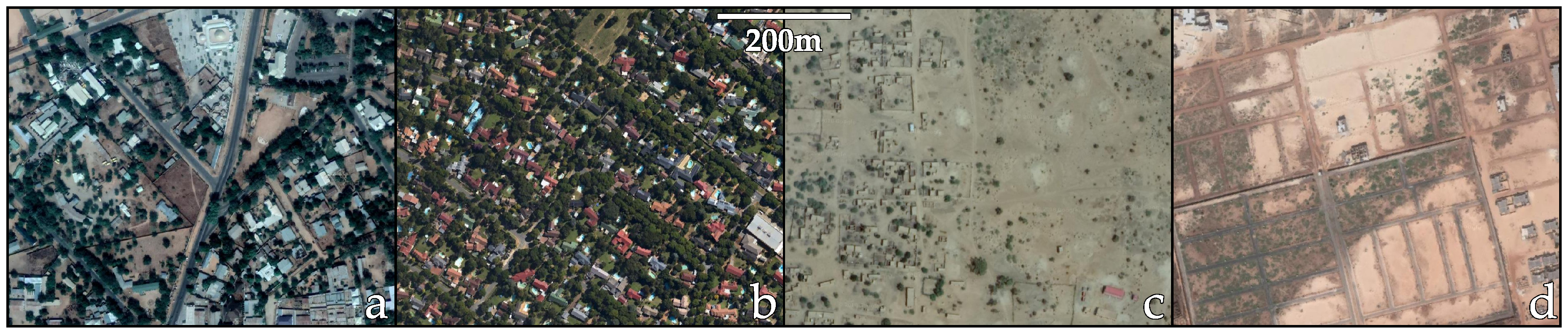
2.1. Case Studies
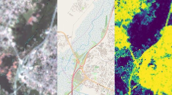
2.2. Satellite Imagery
2.3. Reference Dataset
2.4. OpenStreetMap
2.5. Training Samples
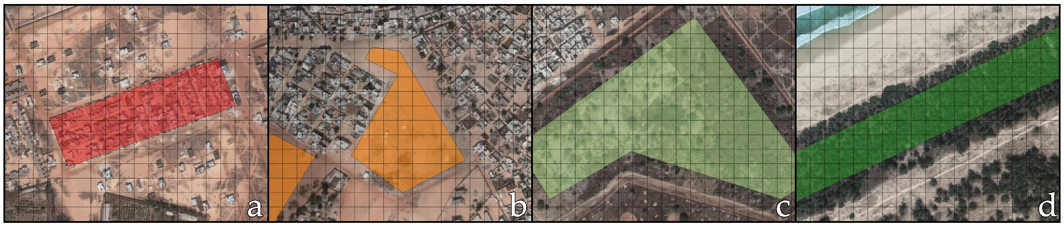
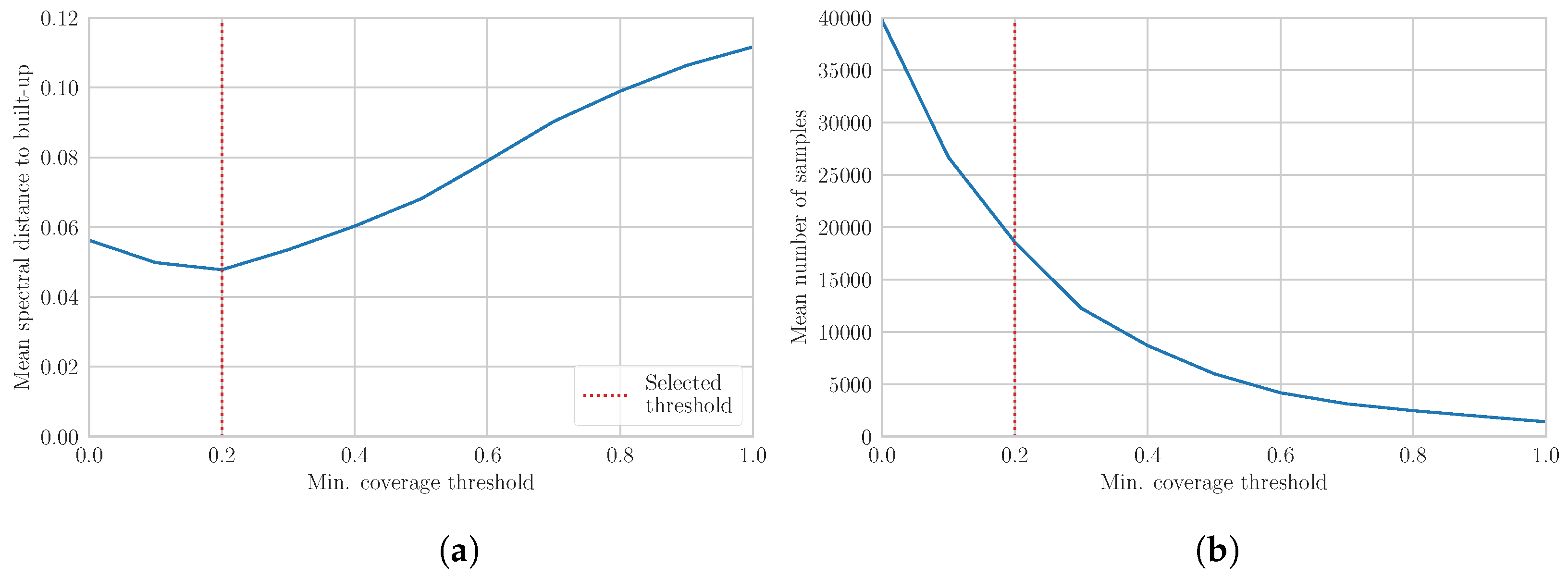
2.5.1. Built-Up Training Samples
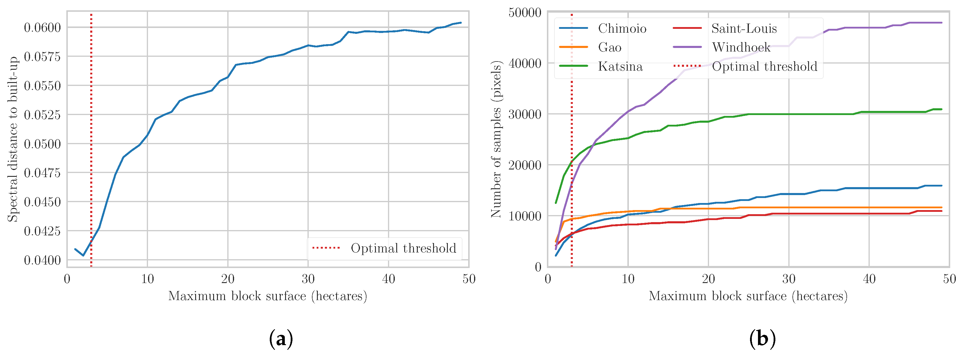
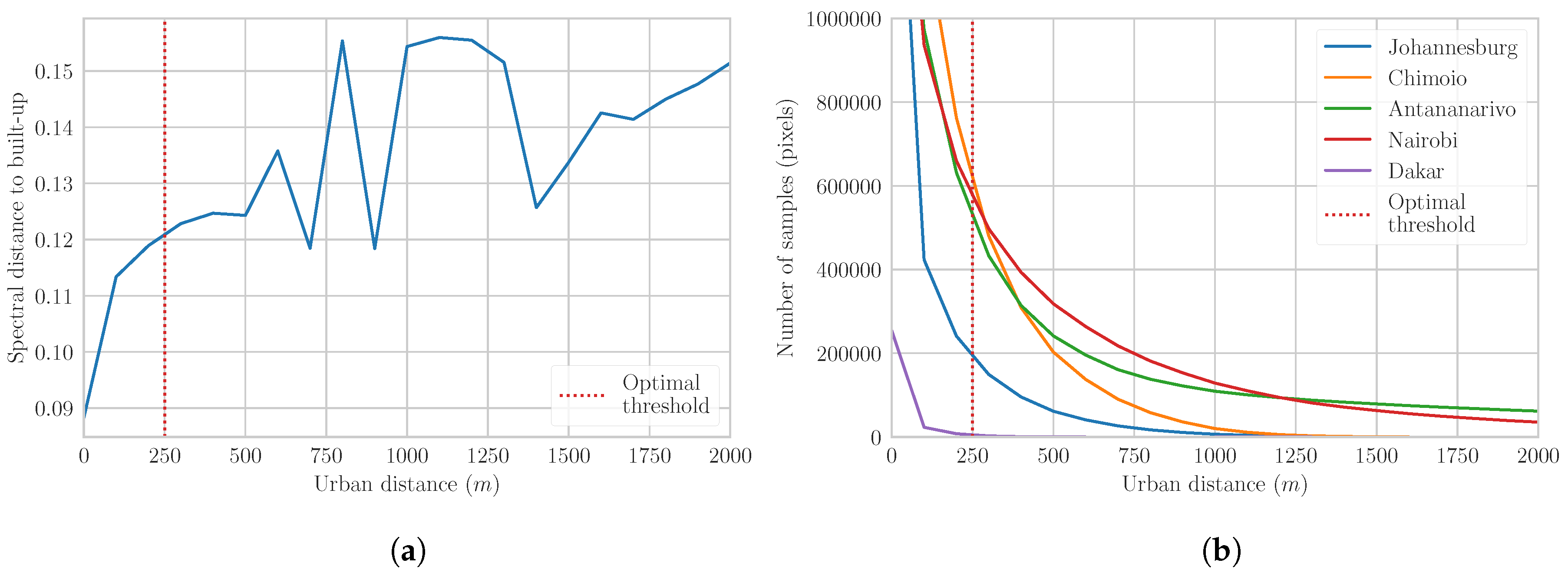
2.5.2. Non-Built-Up Training Samples
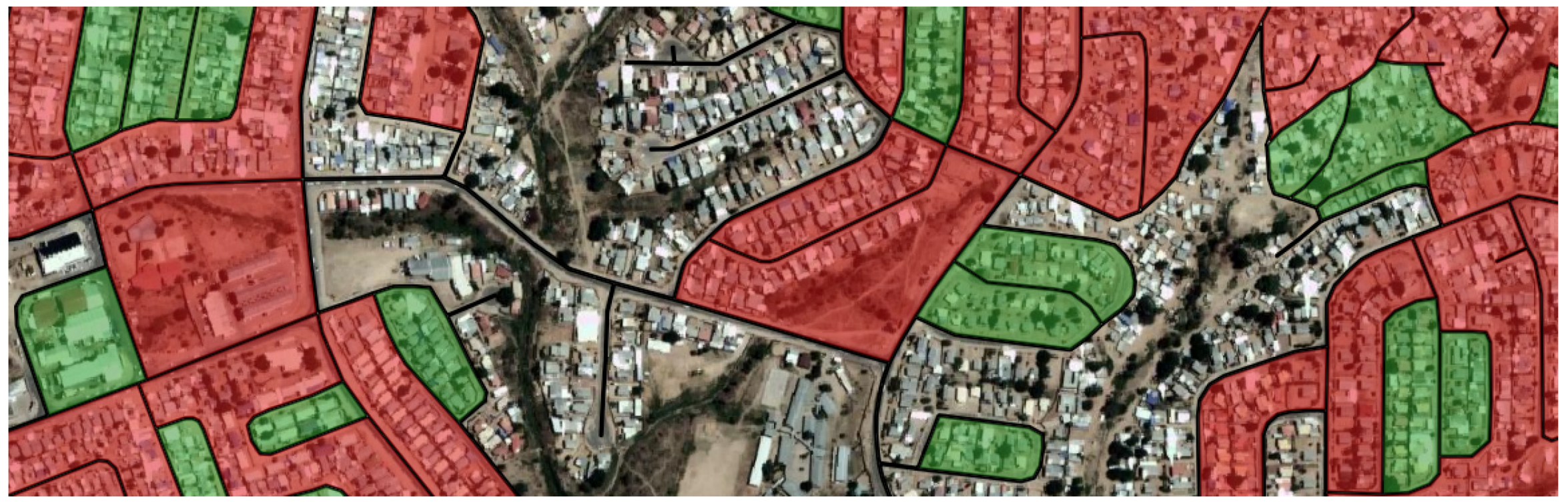
2.5.3. Quality Assessment of Training Samples
2.6. Classification
2.7. Validation
3. Results and Discussion
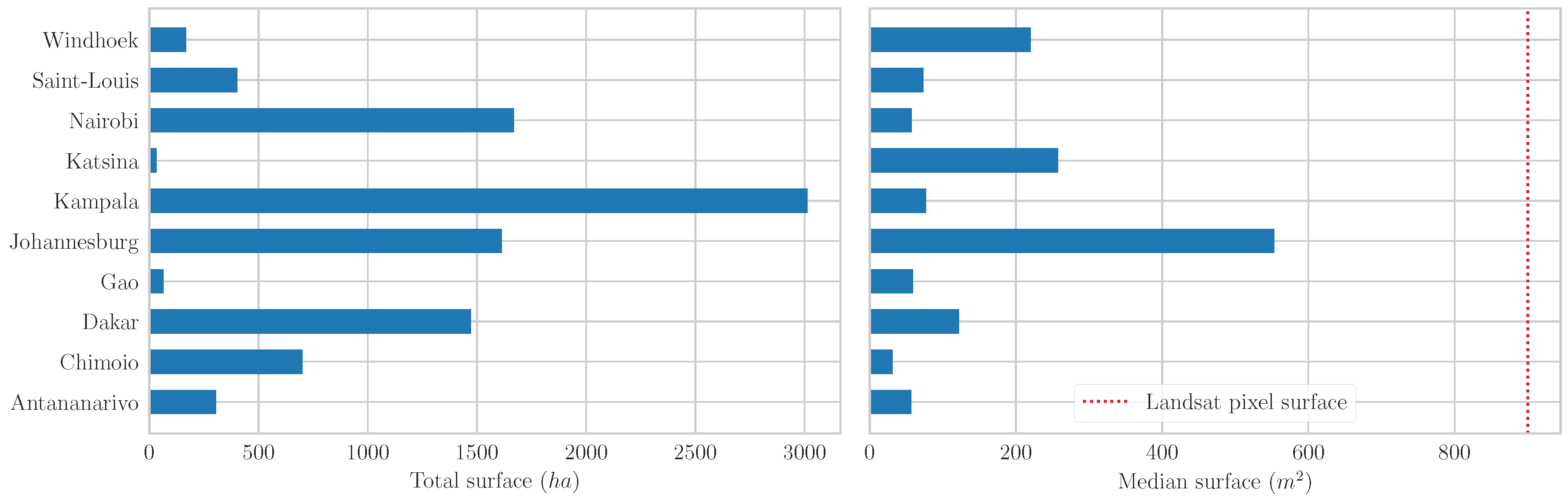
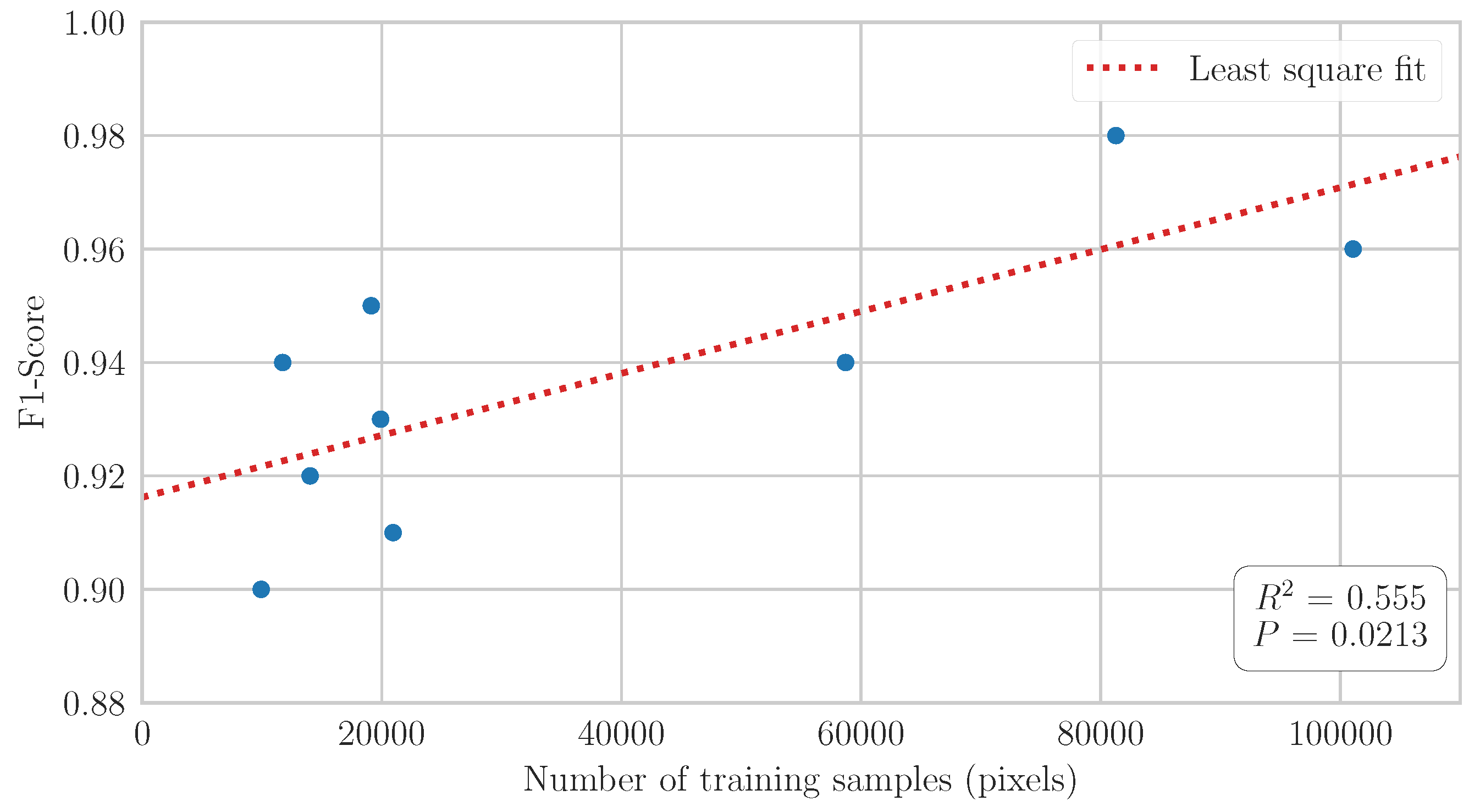
3.1. Built-Up Training Samples
3.2. Non-Built-Up Training Samples
3.3. GHSL and HBASE Assessment
3.4. Classification Results
4. Conclusions
Author Contributions
Funding
Conflicts of Interest
References
- UN-Habitat. The State of African Cities, 2014: Re-Imagining Sustainable Urban Transitions; UN-Habitat: Nairobi, Kenya, 2014. [Google Scholar]
- Grimm, N.B.; Faeth, S.H.; Golubiewski, N.E.; Redman, C.L.; Wu, J.; Bai, X.; Briggs, J.M. Global Change and the Ecology of Cities. Science 2008, 319, 756–760. [Google Scholar] [CrossRef] [PubMed]
- Dye, C. Health and Urban Living. Science 2008, 319, 766–769. [Google Scholar] [CrossRef] [PubMed]
- Wentz, E.; Anderson, S.; Fragkias, M.; Netzband, M.; Mesev, V.; Myint, S.; Quattrochi, D.; Rahman, A.; Seto, K. Supporting Global Environmental Change Research: A Review of Trends and Knowledge Gaps in Urban Remote Sensing. Remote Sens. 2014, 6, 3879–3905. [Google Scholar] [CrossRef]
- Arino, O.; Leroy, M.; Ranera, F.; Gross, D.; Bicheron, P.; Nino, F.; Brockman, C.; Defourny, P.; Vancutsem, C.; Achard, F. Globcover-a Global Land Cover Service with MERIS. In Proceedings of the ENVISAT Symposium, Montreux, Switzerland, 23–27 April 2007; pp. 23–27. [Google Scholar]
- Schneider, A.; Friedl, M.A.; Potere, D. A New Map of Global Urban Extent from MODIS Satellite Data. Environ. Res. Lett. 2009, 4. [Google Scholar] [CrossRef]
- Wulder, M.A.; White, J.C.; Goward, S.N.; Masek, J.G.; Irons, J.R.; Herold, M.; Cohen, W.B.; Loveland, T.R.; Woodcock, C.E. Landsat Continuity: Issues and Opportunities for Land Cover Monitoring. Remote Sens. Environ. 2008, 112, 955–969. [Google Scholar] [CrossRef]
- Pesaresi, M.; Ehrlich, D.; Ferri, S.; Florczyk, A.J.; Freire, S.; Halkia, M.; Julea, A.; Kemper, T.; Soille, P.; Syrris, V. Operating Procedure for the Production of the Global Human Settlement Layer from Landsat Data of the Epochs 1975, 1990, 2000, and 2014; Technical Report; Joint Research Centre, European Commission: Brussels, Belgium; Luxembourg, 2016. [Google Scholar]
- Chen, J.; Chen, J.; Liao, A.; Cao, X.; Chen, L.; Chen, X.; He, C.; Han, G.; Peng, S.; Lu, M.; Zhang, W.; Tong, X.; Mills, J. Global Land Cover Mapping at 30m Resolution: A POK-Based Operational Approach. ISPRS J. Photogramm. Remote Sens. 2015, 103, 7–27. [Google Scholar] [CrossRef]
- Wang, P.; Huang, C.; Brown de Colstoun, E.C.; Tilton, J.C.; Tan, B. Human Built-up And Settlement Extent (HBASE) Dataset From Landsat. 2017. Available online: https://doi.org/10.7927/H4DN434S (accessed on 1 June 2018).
- Herold, M.; Roberts, D.A.; Gardner, M.E.; Dennison, P.E. Spectrometry for Urban Area Remote Sensing—Development and Analysis of a Spectral Library from 350 to 2400 Nm. Remote Sens. Environ. 2004, 91, 304–319. [Google Scholar] [CrossRef]
- Small, C. A Global Analysis of Urban Reflectance. Int. J. Remote Sens. 2005, 26, 661–681. [Google Scholar] [CrossRef]
- Gamba, P.; Herold, M. Global Mapping of Human Settlement: Experiences, Datasets, and Prospects; Taylor & Francis Series in Remote Sensing Applications; CRC Press: Boca Raton, FL, USA, 2009. [Google Scholar]
- Li, M. A Review of Remote Sensing Image Classification Techniques: The Role of Spatio-Contextual Information. Eur. J. Remote Sens. 2014, 389–411. [Google Scholar] [CrossRef]
- Belgiu, M.; Drăguţ, L. Random Forest in Remote Sensing: A Review of Applications and Future Directions. ISPRS J. Photogramm. Remote Sens. 2016, 114, 24–31. [Google Scholar] [CrossRef]
- Potere, D.; Schneider, A.; Angel, S.; Civco, D. Mapping Urban Areas on a Global Scale: Which of the Eight Maps Now Available Is More Accurate? Int. J. Remote Sens. 2009, 30, 6531–6558. [Google Scholar] [CrossRef]
- Trianni, G.; Lisini, G.; Angiuli, E.; Moreno, E.A.; Dondi, P.; Gaggia, A.; Gamba, P. Scaling up to National/Regional Urban Extent Mapping Using Landsat Data. IEEE J. Sel. Top. Appl. Earth Observ. Remote Sens. 2015, 8, 3710–3719. [Google Scholar] [CrossRef]
- Goodchild, M.F. Citizens as Sensors: The World of Volunteered Geography. GeoJournal 2007, 69, 211–221. [Google Scholar] [CrossRef]
- Haklay, M.; Weber, P. OpenStreetMap: User-Generated Street Maps. IEEE Pervas. Comput. 2008, 7, 12–18. [Google Scholar] [CrossRef]
- Mooney, P.; Minghini, M. A Review of OpenStreetMap Data. In Mapping and the Citizen Sensor; Ubiquity Press: London, UK, 2017; pp. 37–59. [Google Scholar]
- Estima, J.; Painho, M. Exploratory Analysis of OpenStreetMap for Land Use Classification. In Proceedings of the Second ACM SIGSPATIAL International Workshop on Crowdsourced and Volunteered Geographic Information, Orlando, FL, USA, 5 November 2013; ACM Press: New York, NY, USA, 2013; pp. 39–46. [Google Scholar] [CrossRef]
- Estima, J.; Painho, M. Investigating the Potential of OpenStreetMap for Land Use/Land Cover Production: A Case Study for Continental Portugal. In OpenStreetMap in GIScience; Jokar Arsanjani, J., Zipf, A., Mooney, P., Helbich, M., Eds.; Springer International Publishing: Cham, Switzerland, 2015; pp. 273–293. [Google Scholar]
- Jokar Arsanjani, J.; Helbich, M.; Bakillah, M.; Hagenauer, J.; Zipf, A. Toward Mapping Land-Use Patterns from Volunteered Geographic Information. Int. J. Geogr. Inf. Sci. 2013, 27, 2264–2278. [Google Scholar] [CrossRef]
- Fonte, C.; Minghini, M.; Patriarca, J.; Antoniou, V.; See, L.; Skopeliti, A. Generating Up-to-Date and Detailed Land Use and Land Cover Maps Using OpenStreetMap and GlobeLand30. ISPRS Int. J. Geo-Inf. 2017, 6, 125. [Google Scholar] [CrossRef]
- Schultz, M.; Voss, J.; Auer, M.; Carter, S.; Zipf, A. Open Land Cover from OpenStreetMap and Remote Sensing. Int. J. Appl. Earth Observ. Geoinf. 2017, 63, 206–213. [Google Scholar] [CrossRef]
- Yang, D.; Fu, C.S.; Smith, A.C.; Yu, Q. Open Land-Use Map: A Regional Land-Use Mapping Strategy for Incorporating OpenStreetMap with Earth Observations. Geo-Spat. Inf. Sci. 2017, 20, 269–281. [Google Scholar] [CrossRef]
- Coleman, D.J.; Georgiadou, Y.; Labonte, J. Volunteered Geographic Information: The Nature and Motivation of Produsers. Int. J. Spat. Data Infrastruct. Res. 2009, 4, 27. [Google Scholar]
- Juhász, L.; Hochmair, H. OSM Data Import as an Outreach Tool to Trigger Community Growth? A Case Study in Miami. ISPRS Int. J. Geo-Inf. 2018, 7, 113. [Google Scholar] [CrossRef]
- Zhang, C.; Chen, Y.; Lu, D. Mapping the Land-Cover Distribution in Arid and Semiarid Urban Landscapes with Landsat Thematic Mapper Imagery. Int. J. Remote Sens. 2015, 36, 4483–4500. [Google Scholar] [CrossRef]
- Li, H.; Wang, C.; Zhong, C.; Su, A.; Xiong, C.; Wang, J.; Liu, J. Mapping Urban Bare Land Automatically from Landsat Imagery with a Simple Index. Remote Sens. 2017, 9, 249. [Google Scholar] [CrossRef]
- Kottek, M.; Grieser, J.; Beck, C.; Rudolf, B.; Rubel, F. World Map of the Köppen-Geiger Climate Classification Updated. Meteorol. Z. 2006, 15, 259–263. [Google Scholar] [CrossRef]
- Linard, C.; Gilbert, M.; Snow, R.W.; Noor, A.M.; Tatem, A.J. Population Distribution, Settlement Patterns and Accessibility across Africa in 2010. PLoS ONE 2012, 7, e31743. [Google Scholar] [CrossRef] [PubMed]
- Vermote, E.; Justice, C.; Claverie, M.; Franch, B. Preliminary Analysis of the Performance of the Landsat 8/OLI Land Surface Reflectance Product. Remote Sens. Environ. 2016, 185, 46–56. [Google Scholar] [CrossRef]
- Zhu, Z.; Woodcock, C.E. Object-Based Cloud and Cloud Shadow Detection in Landsat Imagery. Remote Sens. Environ. 2012, 118, 83–94. [Google Scholar] [CrossRef]
- Zhu, Z.; Wang, S.; Woodcock, C.E. Improvement and Expansion of the Fmask Algorithm: Cloud, Cloud Shadow, and Snow Detection for Landsats 4–7, 8, and Sentinel 2 Images. Remote Sens. Environ. 2015, 159, 269–277. [Google Scholar] [CrossRef]
- Rodriguez-Galiano, V.; Ghimire, B.; Rogan, J.; Chica-Olmo, M.; Rigol-Sanchez, J. An Assessment of the Effectiveness of a Random Forest Classifier for Land-Cover Classification. ISPRS J. Photogramm. Remote Sens. 2012, 67, 93–104. [Google Scholar] [CrossRef]
- Mellor, A.; Boukir, S.; Haywood, A.; Jones, S. Exploring Issues of Training Data Imbalance and Mislabelling on Random Forest Performance for Large Area Land Cover Classification Using the Ensemble Margin. ISPRS J. Photogramm. Remote Sens. 2015, 105, 155–168. [Google Scholar] [CrossRef]
- Oliphant, T.E. Guide to NumPy; Continuum Press: Austin, TX, USA, 2015. [Google Scholar]
- Jones, E.; Oliphant, E.; Peterson, P. SciPy: Open Source Scientific Tools for Python. 2001. Available online: scipy.org (accessed on 1 June 2018).
- Gillies, S.; Perry, M.; Wurster, K.; Ward, B.; Solvsteen, J.; Talbert, C.; McBride, J.; Seglem, E.; Sarago, V.; Fitzsimmons, S.; et al. Rasterio: Geospatial Raster I/O for Python Programmers. 2013. Available online: github.com/mapbox/rasterio (accessed on 1 June 2018).
- Gillies, S.; Tonnhofer, O.; Arnott, J.; Toews, M.; Wasserman, J.; Bierbaum, A.; Adair, A.; Shonberger, J.; Elson, P.; Butler, H.; et al. Shapely: Manipulation and analysis of geometric objects. 2007. Available online: github.com/Toblerity/Shapely (accessed on 1 June 2018).
- Pedregosa, F.; Varoquaux, G.; Gramfort, A.; Michel, V.; Thirion, B.; Grisel, O.; Blondel, M.; Prettenhofer, P.; Weiss, R.; Dubourg, V. Scikit-Learn: Machine Learning in Python. J. Mach. Learn. Res. 2011, 12, 2825–2830. [Google Scholar]
- Angiuli, E.; Trianni, G. Urban Mapping in Landsat Images Based on Normalized Difference Spectral Vector. IEEE Geosci. Remote Sens. Lett. 2014, 11, 661–665. [Google Scholar] [CrossRef]
- Lemaître, G.; Nogueira, F.; Aridas, C.K. Imbalanced-Learn: A Python Toolbox to Tackle the Curse of Imbalanced Datasets in Machine Learning. J. Mach. Learn. Res. 2017, 18, 1–5. [Google Scholar]


| City | Country | Climate | Population |
|---|---|---|---|
| Antananarivo | Madagascar | Subtropical highland | 2,452,000 |
| Chimoio | Mozambique | Humid subtropical | 462,000 |
| Dakar | Senegal | Hot semi-arid | 3,348,000 |
| Gao | Mali | Hot desert | 163,000 |
| Johannesburg | South Africa | Subtropical highland | 4,728,000 |
| Kampala | Uganda | Tropical rainforest | 3,511,000 |
| Katsina | Nigeria | Hot semi-arid | 1,032,000 |
| Nairobi | Kenya | Temperate oceanic | 5,080,000 |
| Saint-Louis | Senegal | Hot desert | 305,000 |
| Windhoek | Namibia | Hot semi-arid | 384,000 |
| City | Landsat Product Identifier | Acquisition Date |
|---|---|---|
| Antananarivo | LC08_L1TP_159073_20150919_20170404_01_T1 | 2015–09–19 |
| Chimoio | LC08_L1TP_168073_20150529_20170408_01_T1 | 2015–05–29 |
| Dakar | LC08_L1TP_206050_20151217_20170331_01_T1 | 2015–12–07 |
| Gao | LC08_L1TP_194049_20160114_20170405_01_T1 | 2016–01–14 |
| Johannesburg | LC08_L1TP_170078_20150831_20170404_01_T1 | 2015–08–31 |
| Kampala | LC08_L1TP_171060_20160129_20170330_01_T1 | 2016–01–29 |
| Katsina | LC08_L1TP_189051_20160111_20170405_01_T1 | 2016–01–11 |
| Nairobi | LC08_L1TP_168061_20160124_20170330_01_T1 | 2016–01–24 |
| Saint-Louis | LC08_L1TP_205049_20161009_20170320_01_T1 | 2016–10–09 |
| Windhoek | LC08_L1TP_178076_20160114_20170405_01_T1 | 2016–01–14 |
| Built-Up | Non-Built-Up | |
|---|---|---|
| Reference built-up polygons | Reference non-built polygons | |
| Building footprints | Non-built features | |
| Building footprints & urban blocks | Non-built features & urban distance |
| GHSL | HBASE | |||||
|---|---|---|---|---|---|---|
| F1-Score | Precision | Recall | F1-Score | Precision | Recall | |
| Antananarivo | 0.83 | 0.82 | 0.83 | 0.79 | 0.67 | 0.96 |
| Chimoio | 0.47 | 0.98 | 0.31 | 0.82 | 0.94 | 0.73 |
| Dakar | 0.85 | 0.74 | 0.99 | 0.81 | 0.69 | 0.98 |
| Gao | 0.35 | 0.98 | 0.21 | 0.72 | 0.94 | 0.59 |
| Johannesburg | 0.92 | 0.86 | 0.99 | 0.90 | 0.82 | 0.99 |
| Kampala | 0.96 | 0.95 | 0.96 | 0.95 | 0.93 | 0.97 |
| Katsina | 0.90 | 0.92 | 0.88 | 0.64 | 0.76 | 0.56 |
| Nairobi | 0.84 | 0.96 | 0.75 | 0.88 | 0.81 | 0.97 |
| Saint Louis | 0.76 | 0.95 | 0.63 | 0.81 | 0.97 | 0.70 |
| Windhoek | 0.81 | 0.92 | 0.73 | 0.78 | 0.65 | 0.99 |
| Mean | 0.77 | 0.91 | 0.73 | 0.81 | 0.82 | 0.85 |
| Standard dev. | 0.20 | 0.08 | 0.28 | 0.09 | 0.12 | 0.18 |
| F1-Score | Precision | Recall | F1-Score | Precision | Recall | F1-Score | Precision | Recall | |
|---|---|---|---|---|---|---|---|---|---|
| Antananarivo | 0.78 | 0.99 | 0.65 | 0.93 | 0.91 | 0.96 | 0.92 | 0.97 | 0.87 |
| Chimoio | 0.77 | 0.63 | 0.97 | 0.92 | 0.90 | 0.95 | 0.85 | 0.93 | 0.79 |
| Dakar | 0.95 | 0.98 | 0.92 | 0.96 | 0.94 | 0.98 | 0.94 | 0.98 | 0.90 |
| Gao | 0.81 | 0.96 | 0.69 | 0.90 | 0.94 | 0.86 | 0.84 | 0.84 | 0.86 |
| Johannesburg | 0.60 | 0.98 | 0.43 | 0.92 | 0.99 | 0.86 | 0.96 | 0.98 | 0.94 |
| Kampala | 0.98 | 1.00 | 0.97 | 0.98 | 0.99 | 0.96 | 0.98 | 0.99 | 0.96 |
| Katsina | 0.20 | 0.84 | 0.11 | 0.91 | 0.95 | 0.87 | 0.94 | 0.99 | 0.90 |
| Nairobi | 0.91 | 0.94 | 0.89 | 0.94 | 0.97 | 0.92 | 0.93 | 0.97 | 0.89 |
| Saint-Louis | 0.95 | 0.98 | 0.93 | 0.94 | 0.92 | 0.96 | 0.92 | 0.98 | 0.88 |
| Windhoek | 0.68 | 0.98 | 0.52 | 0.95 | 0.93 | 0.98 | 0.93 | 0.96 | 0.90 |
| Mean | 0.76 | 0.93 | 0.71 | 0.94 | 0.95 | 0.93 | 0.92 | 0.96 | 0.89 |
| Standard dev. | 0.23 | 0.11 | 0.29 | 0.02 | 0.03 | 0.05 | 0.04 | 0.05 | 0.05 |
© 2018 by the authors. Licensee MDPI, Basel, Switzerland. This article is an open access article distributed under the terms and conditions of the Creative Commons Attribution (CC BY) license (http://creativecommons.org/licenses/by/4.0/).
Share and Cite
Forget, Y.; Linard, C.; Gilbert, M. Supervised Classification of Built-Up Areas in Sub-Saharan African Cities Using Landsat Imagery and OpenStreetMap. Remote Sens. 2018, 10, 1145. https://doi.org/10.3390/rs10071145
Forget Y, Linard C, Gilbert M. Supervised Classification of Built-Up Areas in Sub-Saharan African Cities Using Landsat Imagery and OpenStreetMap. Remote Sensing. 2018; 10(7):1145. https://doi.org/10.3390/rs10071145
Chicago/Turabian StyleForget, Yann, Catherine Linard, and Marius Gilbert. 2018. "Supervised Classification of Built-Up Areas in Sub-Saharan African Cities Using Landsat Imagery and OpenStreetMap" Remote Sensing 10, no. 7: 1145. https://doi.org/10.3390/rs10071145
APA StyleForget, Y., Linard, C., & Gilbert, M. (2018). Supervised Classification of Built-Up Areas in Sub-Saharan African Cities Using Landsat Imagery and OpenStreetMap. Remote Sensing, 10(7), 1145. https://doi.org/10.3390/rs10071145