A Simple Method for the Parameterization of Surface Roughness from Microwave Remote Sensing


Abstract
1. Introduction
2. Material and Methodology
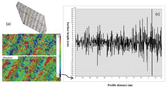
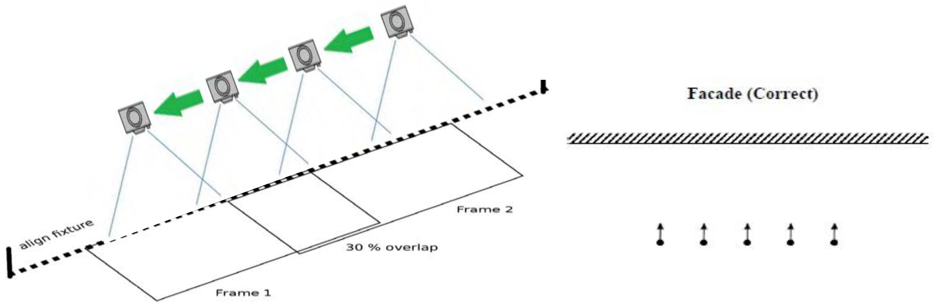
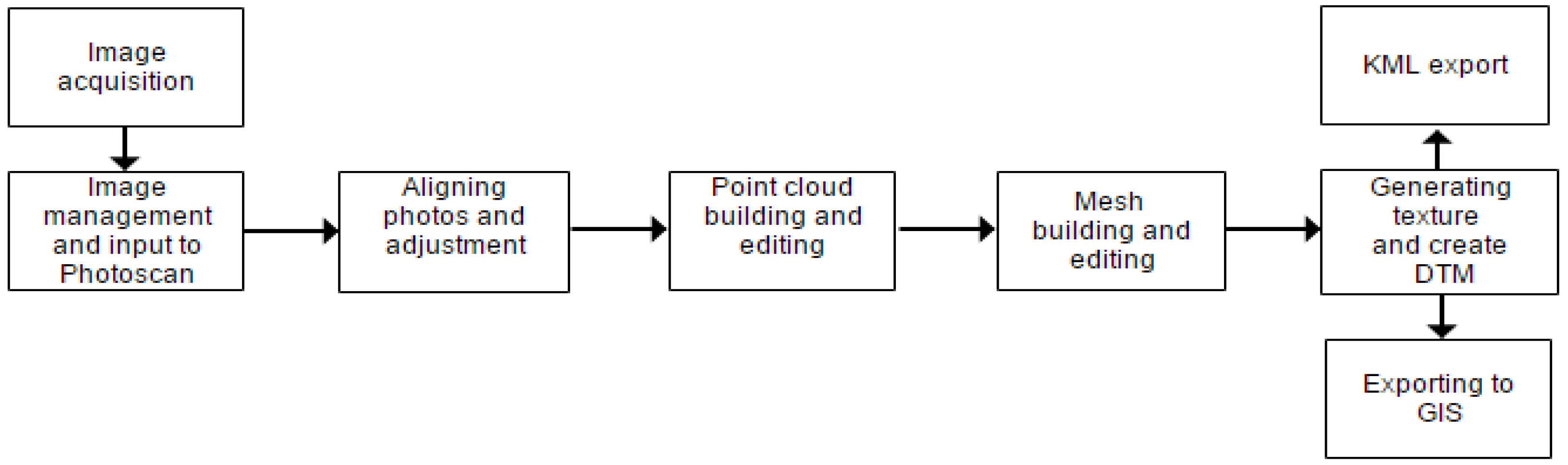
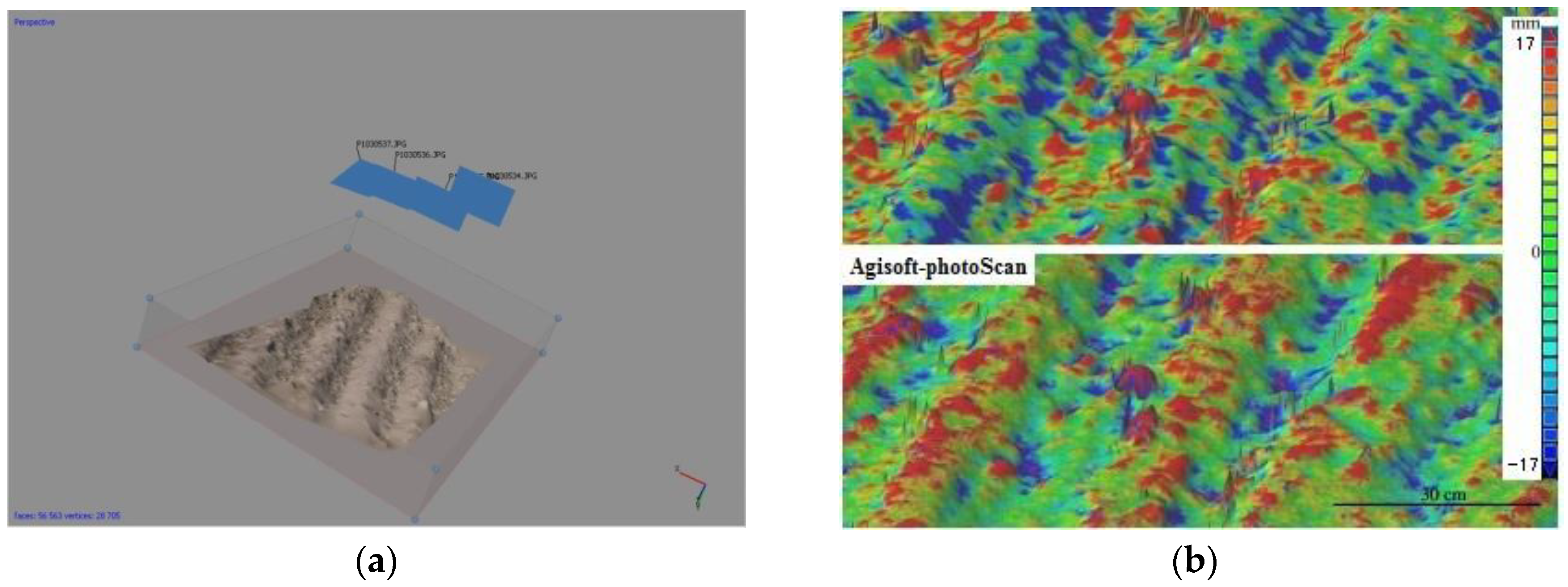
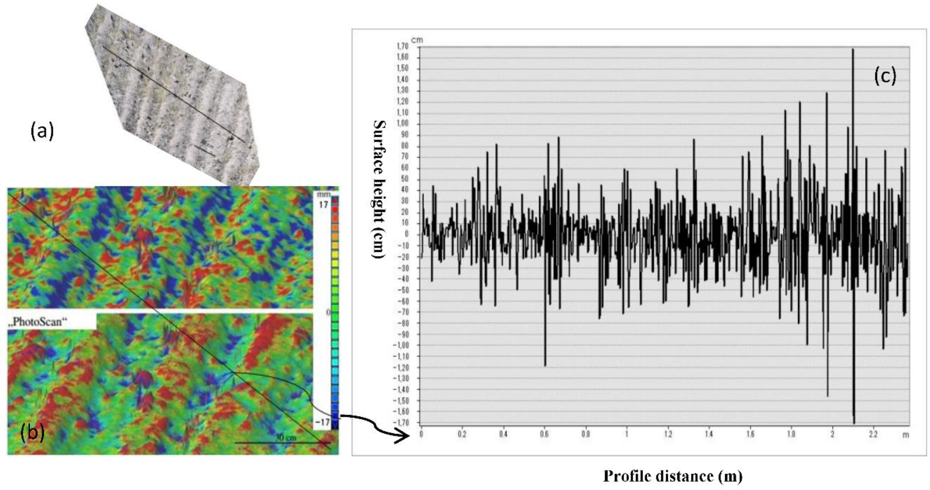
2.1. Image Acquisition and Processing
2.2. Soil Surface Roughness Parameterization
3. Result and Discussion
4. Conclusions
Author Contributions
Funding
Conflicts of Interest
References
- Schuler, D.L.; Lee, J.-S.; Kasilingam, D.; Nesti, G. Surface roughness and slope measurements using polarimetric SAR data. IEEE Trans. Geosci. Remote Sens. 2002, 40, 687–698. [Google Scholar] [CrossRef]
- Gharechelou, S.; Tateishi, R.; Sharma, R.C.; Johnson, B.A. Soil Moisture Mapping in an Arid Area Using a Land Unit Area (LUA) Sampling Approach and Geostatistical Interpolation Techniques. ISPRS Int. J. Geo-Inf. 2016, 5, 35. [Google Scholar] [CrossRef]
- Marzahn, P.; Rieke-Zapp, D.; Ludwig, R. Assessment of soil surface roughness statistics for microwave remote sensing applications using a simple photogrammetric acquisition system. ISPRS J. Photogramm. Remote Sens. 2012, 72, 80–89. [Google Scholar] [CrossRef]
- Snapir, B.; Hobbs, S.; Waine, T. Roughness measurements over an agricultural soil surface with structure from motion. J. Photogramm. Remote Sens. 2014, 96, 210–223. [Google Scholar] [CrossRef]
- Marzahn, P.; Ludwig, R. On the Derivation of Soil Surface Roughness from MultiParametric PolSAR Data and its Potential for Hydrological Modeling. Hydrol. Earth Syst. Sci. 2009, 13, 381–394. [Google Scholar] [CrossRef]
- Marzahn, P.; Seidel, M.; Ludwig, R. Decomposing Dual-Scale Soil Surface Roughness for Microwave Remote Sensing Applications. Remote Sens. 2012, 4, 2016–2032. [Google Scholar] [CrossRef]
- Gharechelou, S.; Tateishi, R.; Sumantyo, J. Interrelationship Analysis of L-Band Backscattering Intensity and Soil Dielectric Constant for Soil Moisture Retrieval Using PALSAR Data. Adv. Remote Sens. 2015, 4, 15–24. [Google Scholar] [CrossRef]
- Oh, Y.; Kay, Y.C. Condition for precise measurement of soil surface roughness. IEEE Trans. Geosci. Remote Sens. 1998, 36, 691–695. [Google Scholar]
- Gharechelou, S.; Tateishi, R.; Sumantyo, J. Comparison of Simulated Backscattering Signal and ALOS PALSAR Backscattering over Arid Environment Using Experimental Measurement. Adv. Remote Sens. 2015, 4, 224–233. [Google Scholar] [CrossRef]
- Verhoest, N.E.C.; Lievens, H.; Wagner, W.; Mozos, J.Ã.; Moran, M.S.; Mattia, F. On the soil roughness parameterization problem in soil moisture retrieval of bare surfaces from synthetic aperture radar. Sensors 2008, 8, 4213–4248. [Google Scholar] [CrossRef] [PubMed]
- Hajnsek, I.; Pottier, E.; Cloude, S.R. Inversion of surface parameters from polarimetric SAR. IEEE Trans. Geosci. Remote Sens. 2003, 41, 727–744. [Google Scholar] [CrossRef]
- Loew, A.; Hajnsek, I.; Schoen, H.; Jagdhuber, T.; Hoekman, D. Exploiting Longer Wavelength SAR Data for the Improvement of Surface Modelling; Tech. Rep. ESA Contract No. 19569/06/NL/HE; ESA: Paris, France, 2008. [Google Scholar]
- Alvarez-Mozos, J.; Verhoest, N.; Larranaga, A.; Casalf, J.; Gonzlez-Audfcana, M. Influence of surface roughness spatial variability and temporal dynamics on the retrieval of soil moisture from SAR observations. Sensors 2009, 9, 463–489. [Google Scholar] [CrossRef] [PubMed]
- Davidson, M.W.J.; Toan, T.L.; Mattia, F.; Satalino, C.; Manninen, T.; Borgeaud, M. On the characterization of agricultural soil roughness for radar remote sensing studies. IEEE Trans. Geosci. Remote Sens. 2000, 38, 630–640. [Google Scholar] [CrossRef]
- Blaes, X.; Defourny, P. Characterizing bidimensional roughness of agricultural soil surfaces for SAR modeling. IEEE Trans. Geosci. Remote Sens. 2008, 46, 4050–4061. [Google Scholar] [CrossRef]
- Milenković, M.; Pfeifer, N.; Glira, P. Applying Terrestrial Laser Scanning for Soil Surface Roughness Assessment. Remote Sens. 2015, 7, 2007–2045. [Google Scholar] [CrossRef]
- Lievens, H.; Vernieuwe, H.; Alvarez-Mozos, J.; De Baets, B.; Verhoest, N. Error in radar-derived soil moisture due to roughness parameterization: an analysis based on synthetical surface profiles. Sensors 2009, 9, 1067–1093. [Google Scholar] [CrossRef] [PubMed]
- Kaźmierowski, C.; Jasiewicz, J.; Zwoliński, Z.; Mitasova, H.; Hengl, T. Soil surface roughness quantification using DEM obtained from UAV photogrammetry. In Geomorphometry for Geosciences, Adam Mickiewicz University in Poznań–Institute of Geoecology and Geoinformation; International Society for Geomorphometry: Tokyo, Japan, 2015. [Google Scholar]
- Rau, J.-Y.; Cheng, C.-K. A cost-effective strategy for multi-scale photo-realistic building modeling and web-based 3-D GIS applications in real estate. Comput. Environ. Urban Syst. 2013, 38, 35–44. [Google Scholar] [CrossRef]
- Jeong, H.H.; Park, J.W.; Kim, J.S.; Choi, C.U. Assessing the Accuracy of Ortho-image using Photogrammetric Unmanned Aerial System. ISPRS Int. Arch. Photogramm. Remote Sens. Spat. Inf. Sci. 2016, XLI-B1, 867–872. [Google Scholar] [CrossRef]
- Kim, J.; Lee, S.; Ahn, H.; Seo, D.; Park, S.; Choi, C. Feasibility of employing a smartphone as the payload in a photogrammetric UAV system. ISPRS J. Photogramm. Remote Sens. 2013, 79, 1–18. [Google Scholar] [CrossRef]
- Baghdadi, N.; El Hajj, M.; Choker, M.; Zribi, M.; Bazzi, H.; Vaudour, E.; Gilliot, J.-M.; Ebengo, D.M. Potential of Sentinel-1 Images for Estimating the Soil Roughness over Bare Agricultural Soils. Water 2018, 10, 131. [Google Scholar] [CrossRef]
- Rieke-Zapp, D.; Tecklenburg, W.; Peipe, J.; Hastedt, H.; Haig, C. Evaluation of the geometric stability and the accuracy potential of digital cameras comparing mechanical stabilisation versus parameterisation. ISPRS J. Photogramm. Remote Sens. 2009, 64, 248–258. [Google Scholar] [CrossRef]
- Rieke-Zapp, D.H. A digital medium-format camera for metric applications—Alpa 12 metric. Photogramm. Rec. 2010, 25, 283–298. [Google Scholar] [CrossRef]
- Barber, M.E.; Grings, F.M.; Álvarez-Mozos, J.; Piscitelli, M.; Perna, P.A.; Karszenbaum, H. Effects of Spatial Sampling Interval on Roughness Parameters and Microwave Backscatter over Agricultural Soil Surfaces. Remote Sens. 2016, 8, 458. [Google Scholar] [CrossRef]
- Orthophoto & DEM Generation (with GCPs). Available online: http://www.agisoft.com/support/tutorials/beginner-level/ (accessed on 28 October 2018).


| Parameter | Values |
|---|---|
| Camera | Canon EOS 550D |
| Lens | Sigma 10–20 mm f/3.5 (set at 10 mm) |
| Sensor size (mm) | 22.3 × 14.9 |
| Image size (Mo) | 6 (raw), 0.6 (compressed) |
| Resolution (pixels) | 1728 × 1152 |
| Focal length (mm) | 16 |
| x (mm) | y (mm) | z (mm) | |
|---|---|---|---|
| Point 1 | 0.247 | 0.101 | −0.504 |
| Point 2 | −0.565 | 0.292 | −0.392 |
| Point 3 | −0.536 | 0.341 | −0.704 |
| Point 4 | 0.589 | 0.442 | −0.516 |
| Mean error | 0.070 | 0.240 | −0.710 |
| Mean RMSE | 0.493 | 0.441 | 0.878 |
| Parameter | Stereo-Photogrammetric Setup (DEM) |
|---|---|
| Image acquisition height | 1 m Sigma 10–20 mm f/3.5, set at 10 mm |
| Number of images | 50 |
| Image overlap | 60–85% |
| Average point cloud density | 10 points/cm2 |
| DEM size | 2 × 3 m |
| DEM grid resolution | 1 mm |
| Roughness Type | RMS Height | Ground Real Photo |
|---|---|---|
| Slightly rough (disk tillage) | <2.5 cm |  |
| Moderately rough (plowed field) | 2.5–4 cm |  |
| Rough (furrow field) | >4 cm |  |
© 2018 by the authors. Licensee MDPI, Basel, Switzerland. This article is an open access article distributed under the terms and conditions of the Creative Commons Attribution (CC BY) license (http://creativecommons.org/licenses/by/4.0/).
Share and Cite
Gharechelou, S.; Tateishi, R.; A. Johnson, B. A Simple Method for the Parameterization of Surface Roughness from Microwave Remote Sensing. Remote Sens. 2018, 10, 1711. https://doi.org/10.3390/rs10111711
Gharechelou S, Tateishi R, A. Johnson B. A Simple Method for the Parameterization of Surface Roughness from Microwave Remote Sensing. Remote Sensing. 2018; 10(11):1711. https://doi.org/10.3390/rs10111711
Chicago/Turabian StyleGharechelou, Saeid, Ryutaro Tateishi, and Brian A. Johnson. 2018. "A Simple Method for the Parameterization of Surface Roughness from Microwave Remote Sensing" Remote Sensing 10, no. 11: 1711. https://doi.org/10.3390/rs10111711
APA StyleGharechelou, S., Tateishi, R., & A. Johnson, B. (2018). A Simple Method for the Parameterization of Surface Roughness from Microwave Remote Sensing. Remote Sensing, 10(11), 1711. https://doi.org/10.3390/rs10111711