The Role of Earth Observation, with a Focus on SAR Interferometry, for Sinkhole Hazard Assessment


Abstract

1. Introduction to Sinkhole Hazards
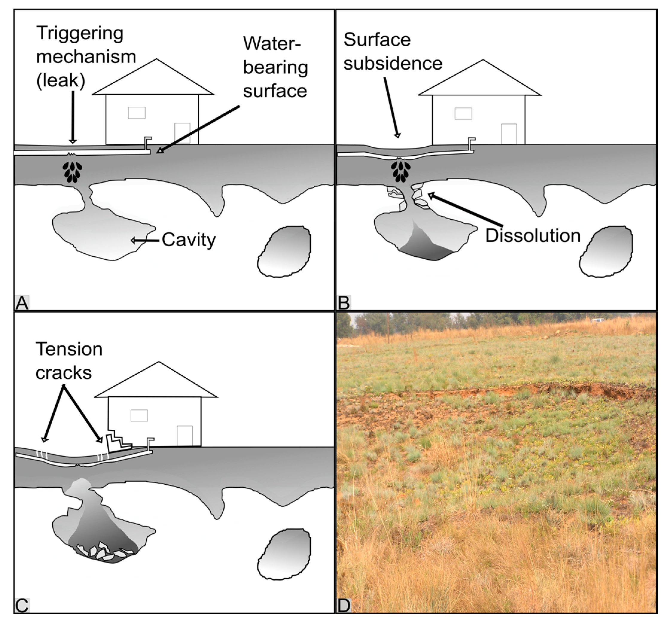
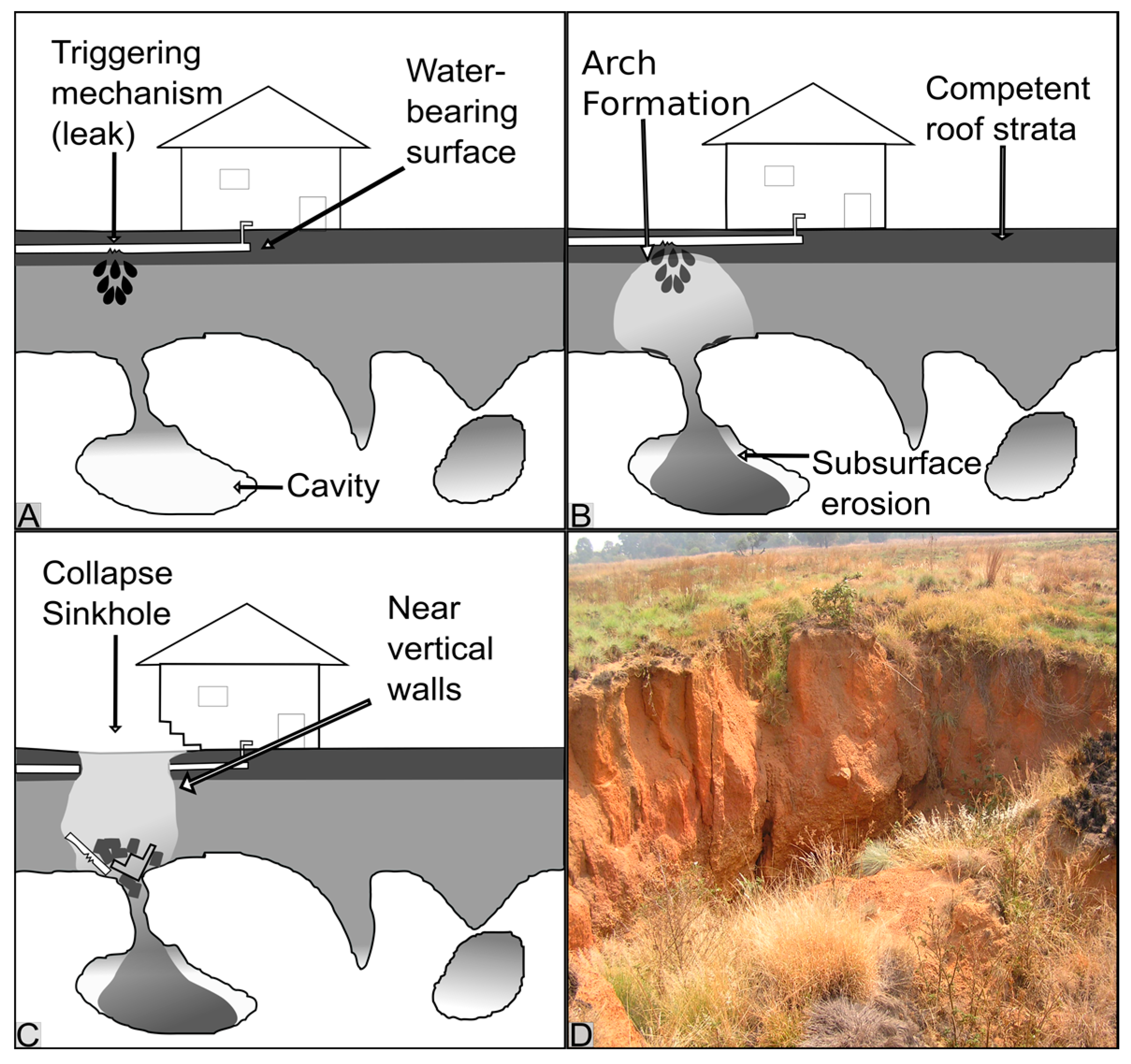
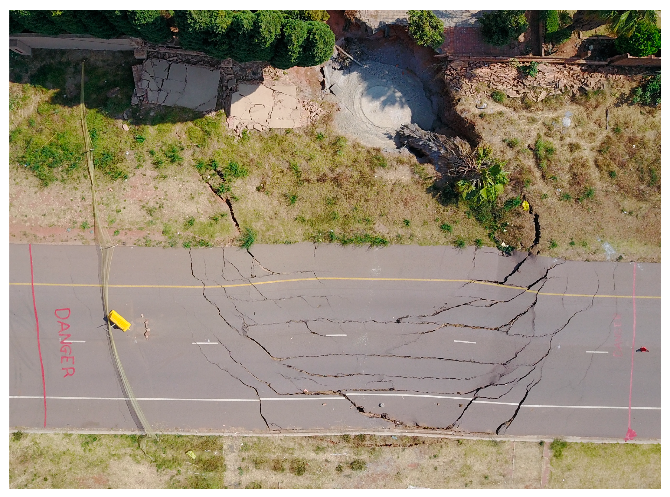
2. Mechanisms of Sinkhole Formation
3. Statistical Modelling and Probabilistic Sinkhole Hazard Assessment
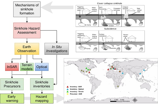
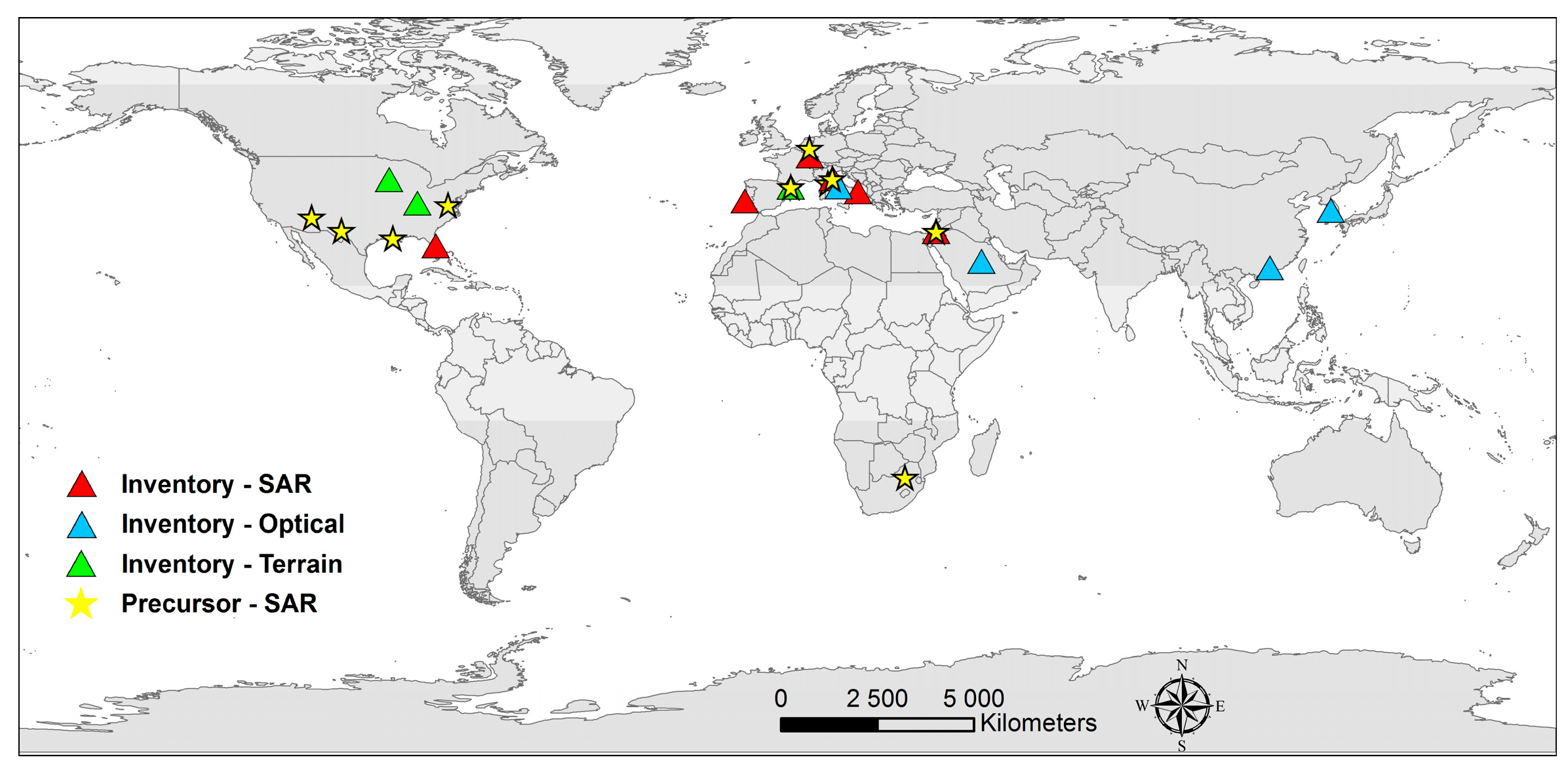
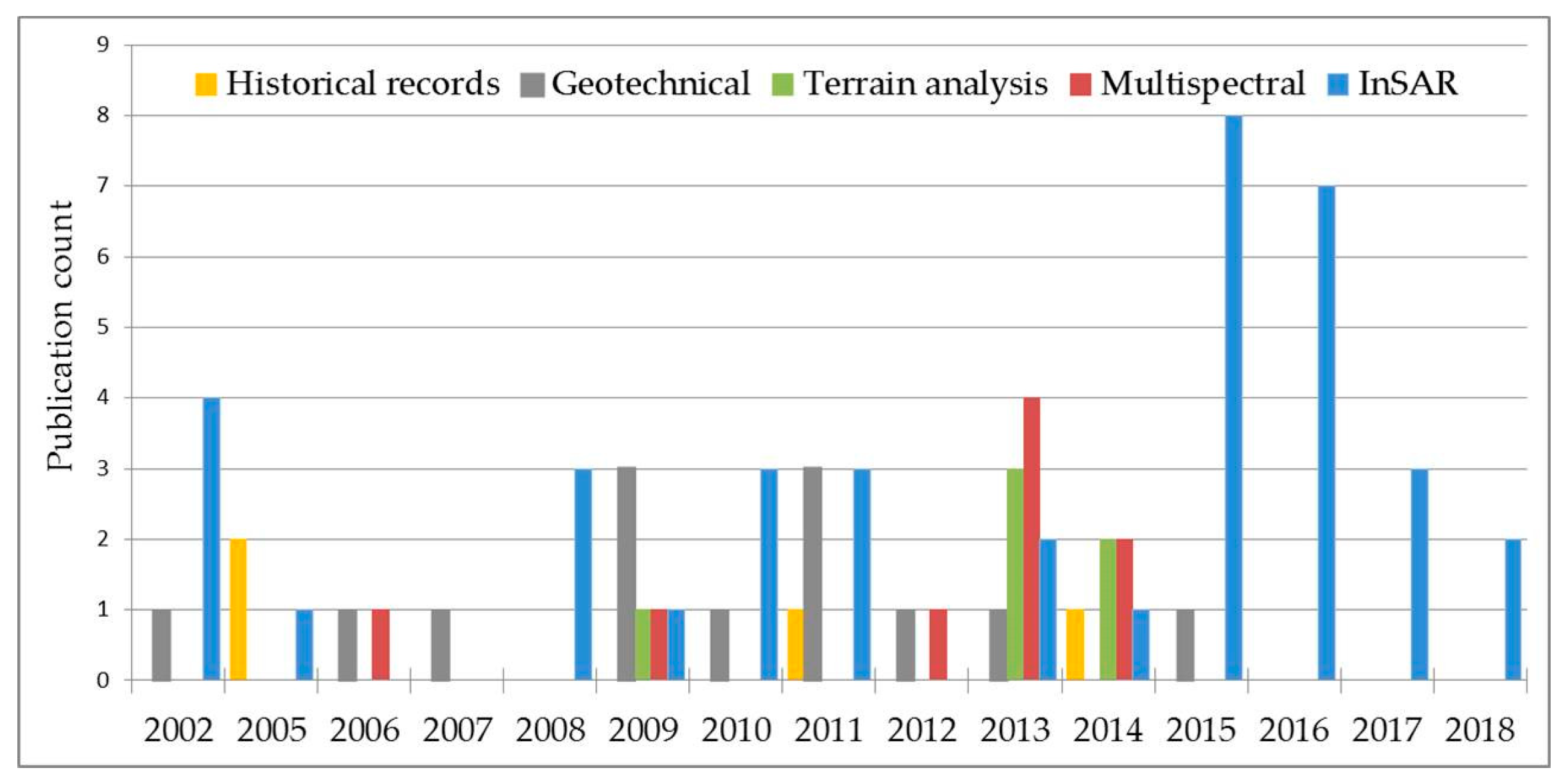
4. The role of Earth Observation in Sinkhole Hazard Assessment
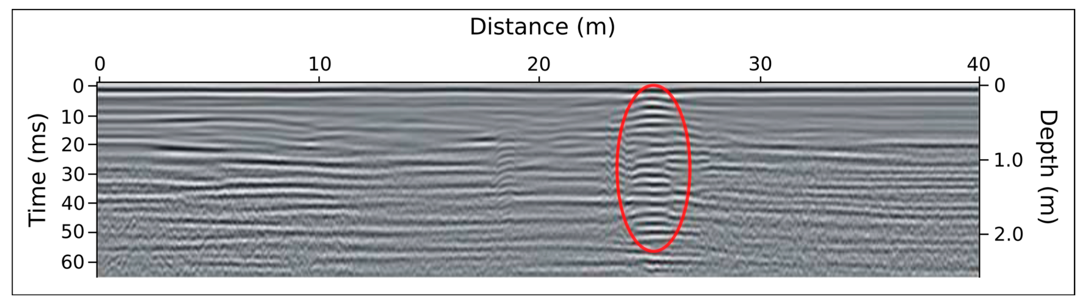
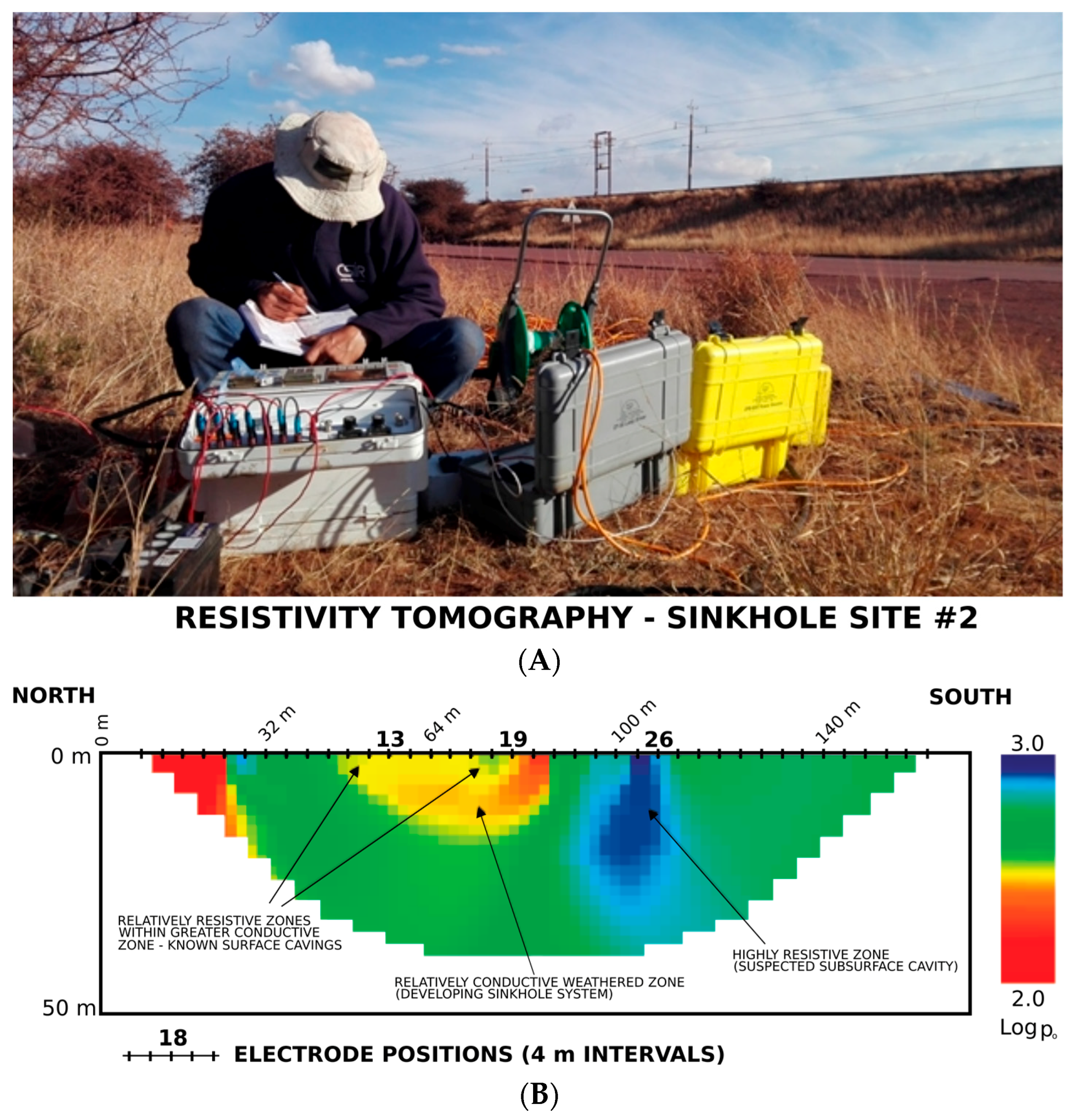
4.1. Compilation of Sinkhole Inventories
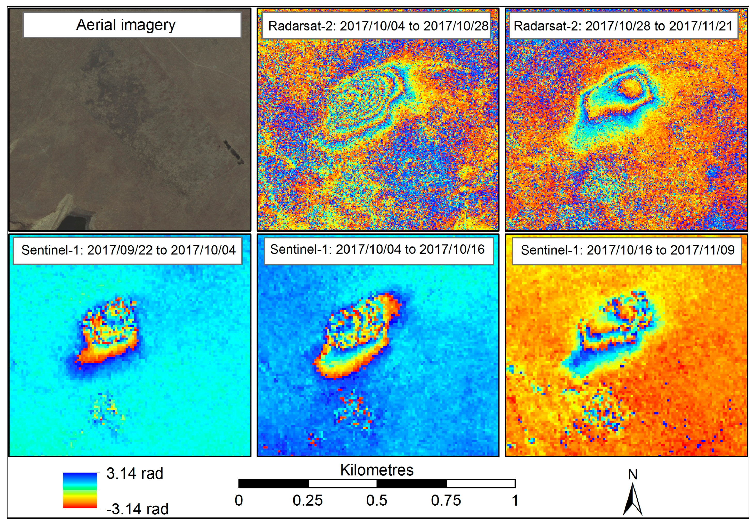
4.2. Detecting Precursors to Sinkhole Development
5. Discussion and Perspectives—Towards Operational Sinkhole Early Warning
6. Concluding Remarks
Author Contributions
Funding
Acknowledgments
Conflicts of Interest
References
- Buttrick, D.B.; Trollip, N.Y.G.; Watermeyer, R.B.; Pieterse, N.D.; Gerber, A.A. A performance based approach to dolomite risk management. Environ. Earth Sci. 2011, 64, 1127–1138. [Google Scholar] [CrossRef]
- Calo, F.; Fornaro, G.; Parise, M.; Zeni, G. The SBAS-DINSAR approach for the spatial and temporal analysis of sinkhole phenomena. Proc. Fringe 2011. [Google Scholar] [CrossRef]
- De Waele, J.; Gutiérrez, F.; Parise, M.; Plan, L. Geomorphology and natural hazards in karst areas: A review. Geomorphology 2011, 134, 1–8. [Google Scholar] [CrossRef]
- Paine, J.G.; Buckley, S.M.; Collins, E.W.; Wilson, C.R. Assessing collapse risk in evaporite sinkhole-prone areas using microgravimetry and Radar Interferometry. J. Environ. Eng. Geophys. 2012, 17, 75–87. [Google Scholar] [CrossRef]
- Jones, C.E.; Blom, R.G. Bayou Corne, Louisiana, sinkhole: Precursory deformation measured by radar interferometry. Geology 2014, 42, 111–114. [Google Scholar] [CrossRef]
- Nof, R.N.; Baer, G.; Ziv, A.; Raz, E.; Atzori, S.; Salvi, S. Sinkhole precursors along the Dead Sea, Israel, revealed by SAR interferometry. Geology 2013, 41, 1019–1022. [Google Scholar] [CrossRef]
- Parise, M.; Closson, D.; Gutiérrez, F.; Stevanović, Z. Anticipating and managing engineering problems in the complex karst environment. Environ. Earth Sci. 2015, 74, 7823–7835. [Google Scholar] [CrossRef]
- Oosthuizen, A.C.; Richardson, S. Sinkholes and subsidence in South Africa. Counc. Geosci. Rep. 2011, 27, 1–31. [Google Scholar]
- Zhou, W.; Beck, B.F. Management and mitigation of sinkholes on karst lands: An overview of practical applications. Environ. Geol. 2008, 55, 837–851. [Google Scholar] [CrossRef]
- Joyce, K.E.; Wright, K.C.; Samsonov, S.V.; Ambriosa, V.G. Remote sensing and the disaster management cycle. In Advances in Geoscience and Remote Sensing; Jedlovec, G., Ed.; InTech: London, UK, 2009; pp. 317–346. ISBN 978-953-307-005-6. [Google Scholar]
- Gutiérrez, F.; Parise, M.; De Waele, J.; Jourde, H. A review on natural and human-induced geohazards and impacts in karst. Earth-Sci. Rev. 2014, 138, 61–88. [Google Scholar] [CrossRef]
- Gutiérrez, F.; Cooper, A.H.; Johnson, K.S. Identification, prediction, and mitigation of sinkhole hazards in evaporite karst areas. Environ. Geol. 2008, 53, 1007–1022. [Google Scholar] [CrossRef]
- Richardson, S. Sinkhole and Subsidence Record in the Chuniespoort Group Dolomite, Gauteng, South Africa. University of Pretoria: Pretoria, South Africa, 2013. [Google Scholar]
- Van Den Eeckhaut, M.; Poesen, J.; Dusar, M.; Martens, V.; Duchateau, P. Sinkhole formation above underground limestone quarries: A case study in South Limburg (Belgium). Geomorphology 2007, 91, 19–37. [Google Scholar] [CrossRef]
- Galve, J.P.; Gutiérrez, F.; Remondo, J.; Bonachea, J.; Lucha, P.; Cendrero, A. Evaluating and comparing methods of sinkhole susceptibility mapping in the Ebro Valley evaporite karst (NE Spain). Geomorphology 2009, 111, 160–172. [Google Scholar] [CrossRef]
- Tomás, R.; Romero, R.; Mulas, J.; Marturià, J.J.; Mallorquí, J.J.; Lopez-Sanchez, J.M.; Herrera, G.; Gutiérrez, F.; González, P.J.; Fernández, J.; et al. Radar interferometry techniques for the study of ground subsidence phenomena: A review of practical issues through cases in Spain. Environ. Earth Sci. 2014, 71, 163–181. [Google Scholar] [CrossRef]
- Youssef, A.M.; Al-Harbi, H.M.; Gutiérrez, F.; Zabramwi, Y.A.; Bulkhi, A.B.; Zahrani, S.A.; Bahamil, A.M.; Zahrani, A.J.; Otaibi, Z.A.; El-Haddad, B.A. Natural and human-induced sinkhole hazards in Saudi Arabia: Distribution, investigation, causes and impacts. Hydrogeol. J. 2015, 24, 625–644. [Google Scholar] [CrossRef]
- Gutiérrez, F.; Guerrero, J.; Lucha, P. Quantitative sinkhole hazard assessment. A case study from the Ebro Valley evaporite alluvial karst (NE Spain). Nat. Hazards 2008, 45, 211–233. [Google Scholar] [CrossRef]
- Theron, A.; Engelbrecht, J.; Kemp, J.; Kleynhans, W.; Turnbull, T. Detection of sinkhole precursors through SAR interferometry: First results from South Africa. In Proceedings of the IEEE International Geoscience and Remote Sensing Symposium, Beijing, China, 10–15 July 2016; pp. 5398–5401. [Google Scholar]
- Theron, A.; Engelbrecht, J.; Kemp, J.; Kleynhans, W.; Turnbull, T. Detection of Sinkhole Precursors through SAR Interferometry: Radar and Geological Considerations. IEEE Geosci. Remote Sens. Lett. 2017, 14, 871–875. [Google Scholar] [CrossRef]
- Vaccari, A.; Stuecheli, M.; Bruckno, B.; Hoppe, E.; Acton, S.T. Detection of geophysical features in InSAR point cloud data sets using spatiotemporal models. Int. J. Remote Sens. 2013, 34, 8215–8234. [Google Scholar] [CrossRef]
- Gutiérrez, F.; Galve, J.P.; Lucha, P.; Castañeda, C.; Bonachea, J.; Guerrero, J. Integrating geomorphological mapping, trenching, InSAR and GPR for the identification and characterization of sinkholes: A review and application in the mantled evaporite karst of the Ebro Valley (NE Spain). Geomorphology 2011, 134, 144–156. [Google Scholar] [CrossRef]
- Yilmaz, I.; Marschalko, M.; Bednarik, M. Gypsum collapse hazards and importance of hazard mapping. Carbonates Evaporites 2011, 26, 193–209. [Google Scholar] [CrossRef]
- Parise, M.; Lollino, P. A preliminary analysis of failure mechanisms in karst and man-made underground caves in Southern Italy. Geomorphology 2011, 134, 132–143. [Google Scholar] [CrossRef]
- Batayneh, A.T.; Abueladas, A.A.; Moumani, K.A. Use of ground-penetrating radar for assessment of potential sinkhole conditions: An example from Ghor al Haditha area, Jordan. Environ. Geol. 2002, 41, 977–983. [Google Scholar] [CrossRef]
- Intrieri, E.; Gigli, G.; Nocentini, M.; Lombardi, L.; Mugnai, F.; Fidolini, F.; Casagli, N. Sinkhole monitoring and early warning: An experimental and successful GB-InSAR application. Geomorphology 2015, 241, 304–314. [Google Scholar] [CrossRef]
- Closson, D.; Karaki, N.A.; Klinger, Y.; Hussein, M.J. Subsidence and sinkhole hazard assessment in the Southern Dead Sea area, Jordan. Pure Appl. Geophys. 2005, 162, 221–248. [Google Scholar] [CrossRef]
- Raspini, F.; Bianchini, S.; Ciampalini, A.; Del Soldato, M.; Solari, L.; Novali, F.; Del Conte, S.; Rucci, A.; Ferretti, A.; Casagli, N. Continuous, semi-automatic monitoring of ground deformation using Sentinel-1 satellites. Sci. Rep. 2018. [Google Scholar] [CrossRef] [PubMed]
- Trollip, N.Y.G. The Geology of an Area South of Pretoria with Specific Reference to Dolomite Stability. Master’s Thesis, University of Pretoria, Pretoria, South Africa, 2006. [Google Scholar]
- Frumkin, A.; Ezersky, M.; Al-Zoubi, A.; Akkawi, E.; Abueladas, A.R. The Dead Sea sinkhole hazard: Geophysical assessment of salt dissolution and collapse. Geomorphology 2011, 134, 102–117. [Google Scholar] [CrossRef]
- Kaufmann, O.; Quinif, Y. Geohazard map of cover-collapse sinkholes in the “Tournaisis” area, southern Belgium. Eng. Geol. 2002, 65, 117–124. [Google Scholar] [CrossRef]
- Momubaghan, G.A. Geotechnical Investigations for the Gautrain Mass Transit Rapid Link over Dolomite Bedrock in the Centurion Area. Master’s Thesis, University of Pretoria, Pretoria, South Africa, 2012. [Google Scholar]
- Larry, D.; Seale, J. Creation, Analysis, and Evaluation of Remote Sensing Sinkhole Databases for Florida. Master’s Thesis, University of South Florida, Tampa, FL, USA, 2005. [Google Scholar]
- Chang, L.; Hanssen, R.F. Detection of cavity migration and sinkhole risk using radar interferometric time series. Remote Sens. Environ. 2014, 147, 56–64. [Google Scholar] [CrossRef]
- Szwedzicki, T. Geotechnical precursors to large-scale ground collapse in mines. Int. J. Rock Mech. Min. Sci. 2001, 38, 957–965. [Google Scholar] [CrossRef]
- Yechieli, Y.; Abelson, M.; Baer, G. Sinkhole formation and subsidence along the Dead Sea coast, Israel. Hydrogeol. J. 2015, 601–612. [Google Scholar] [CrossRef]
- Galve, J.P.; Gutiérrez, F.; Lucha, P.; Guerrero, J.; Bonachea, J.; Remondo, J.; Cendrero, A. Probabilistic sinkhole modelling for hazard assessment. Earth Surf. Process. Landf. 2009, 34, 437–452. [Google Scholar] [CrossRef]
- Gao, Y.; Alexander, E.C. Sinkhole hazard assessment in Minnesota using a decision tree model. Environ. Geol. 2008, 54, 945–956. [Google Scholar] [CrossRef]
- Galve, J.P.; Remondo, J.; Gutiérrez, F. Improving sinkhole hazard models incorporating magnitude-frequency relationships and nearest neighbor analysis. Geomorphology 2011, 134, 157–170. [Google Scholar] [CrossRef]
- Engelbrecht, J. Parameters Affecting Interferometric Coherence and Implications for Long-term Operational Monitoring of Mining-induced Surface Deformation; University of Cape Town: Cape Town, South Africa, 2013; pp. 1–171. [Google Scholar]
- Engelbrecht, J.; Inggs, M.R.; Makusha, G. Detection and monitoring of surface subsidence associated with mining activities in the Witbank Coalfields, South Africa, using differential radar interferometry. S. Afr. J. Geol. 2011, 114, 77–94. [Google Scholar] [CrossRef]
- Engelbrecht, J.; Musekiwa, C.; Kemp, J.; Inggs, M.R. Parameters affecting interferometric coherence-the case of a dynamic agricultural region. IEEE Trans. Geosci. Remote Sens. 2014, 52, 1572–1582. [Google Scholar] [CrossRef]
- Engelbrecht, J.; Inggs, M. Recommendations for long-term operational dinsar monitoring of mining-induced deformation in a dynamic agricultural region. In Proceedings of the IEEE International Geoscience and Remote Sensing Symposium, Melbourne, Australia, 21–26 July 2013; pp. 2912–2915. [Google Scholar]
- Gillespie, T.W.; Chu, J.; Thomas, D. Assessment and prediction of natural hazards from satellite imagery. Prog. Phys. Geogr. 2007, 31, 459–470. [Google Scholar] [CrossRef] [PubMed]
- Calvo, A.B.; Gutiérrez, F. 4D Monitoring of Active Sinkholes with a Terrestrial Laser Scanner (TLS): A Case Study in the Evaporite Karst of the Ebro Valley, NE Spain. Remote Sens. 2018. [Google Scholar] [CrossRef]
- Joyce, K.E.; Belliss, S.E.; Sergey, V.; McNeill, S.J.; Glassey, P.J.; Samsonov, S.V.; McNeill, S.J.; Glassey, P.J. A review of the status of satellite remote sensing and image processing techniques for mapping natural hazards and disasters. Prog. Phys. Geogr. 2009, 33, 183–207. [Google Scholar] [CrossRef]
- SafeLand D4.4. Guidelines for the Selection of Appropriate Remote Sensing Technologies for Monitoring Different Types of Landslides. Available online: https://www.ngi.no/download/file/6014 (accessed on 2 August 2018).
- Salvati, R.; Sasowsky, I.D. Development of collapse sinkholes in areas of groundwater discharge. J. Hydrol. 2002, 264, 1–11. [Google Scholar] [CrossRef]
- Alfarrah, N.; Berhane, G.; Hweesh, A.; Walraevens, K. Sinkholes Due to Groundwater Withdrawal in Tazerbo Wellfield, SE Libya. Groundwater 2017. [Google Scholar] [CrossRef] [PubMed]
- Hadjimitsis, D.G.; Agapiou, A.; Themistocleous, K.; Alexakis, D.D.; Toulios, G.; Perdikou, S.; Sarris, A.; Toulios, L.; Clayton, C. Detection of Water Pipes and Leakages in Rural Water Supply Networks Using Remote Sensing Techniques. In Remote Sensing of Environment: Integrated Approaches; InTech: London, UK, 2011. [Google Scholar]
- Agapiou, A.; Alexakis, D.D.; Themistocleous, K.; Hadjimitsis, G. Water leakage detection using remote sensing, field spectroscopy and GIS in semiarid areas of Cyprus. Urban Water J. 2016, 13, 221–231. [Google Scholar] [CrossRef]
- Zanganeh, R.; Mojaradi, B.; Jabbari, E. Leak Detection from the Buried Water Transmission Pipeline Using Landsat 8 Satellite Images (Case Study of the Kosar Water Transmission Pipeline). In Proceedings of the International Conference on Civil Engineering, Tehran, Iran, 8–10 May 2016. [Google Scholar]
- Castellazzi, P.; Longuevergne, L.; Martel, R.; Rivera, A.; Brouard, C.; Chaussard, E. Remote Sensing of Environment Quantitative mapping of groundwater depletion at the water management scale using a combined GRACE/InSAR approach. Remote Sens. Environ. 2018, 205, 408–418. [Google Scholar] [CrossRef]
- Chaussard, E.; Milillo, P.; Burgmann, R.; Perissin, D.; Fielding, E.J.; Baker, B. Remote sensing of ground deformation for monitoring groundwater management practices: Application to the Santa Clara Valley during the 2012–2015 California drought. J. Geophys. Res. B Solid Earth 2017. [Google Scholar] [CrossRef]
- Amos, C.B.; Audet, P.; Hammond, W.C.; Bürgmann, R.; Johanson, I.A.; Blewitt, G. Uplift and seismicity driven by groundwater depletion in central California. Nature 2014, 509, 483–486. [Google Scholar] [CrossRef] [PubMed]
- Carbonel, D.; Rodríguez, V.; Gutiérrez, F.; Mccalpin, J.P.; Linares, R.; Roqué, C.; Zarroca, M.; Guerrero, J.; Sasowsky, I. Evaluation of trenching, ground penetrating radar (GPR) and electrical resistivity tomography (ERT) for sinkhole characterization. Earth Surf. Process. Landf. 2014, 39, 214–227. [Google Scholar] [CrossRef]
- Billi, A.; De Filippis, L.; Poncia, P.P.; Sella, P.; Faccenna, C. Hidden sinkholes and karst cavities in the travertine plateau of a highly-populated geothermal seismic territory (Tivoli, central Italy). Geomorphology 2016, 255, 63–80. [Google Scholar] [CrossRef]
- Van Schoor, M. Detection of sinkholes using 2D electrical resistivity imaging. J. Appl. Geophys. 2002, 50, 393–399. [Google Scholar] [CrossRef]
- Van Schoor, M. Detecting and monitoring of geological hazards with geophysics. PositionIT 2013, 8, 16–19. [Google Scholar]
- Joyce, K.E.; Samsonov, S.V.; Levick, S.R.; Engelbrecht, J.; Belliss, S. Mapping and monitoring geological hazards using optical, LiDAR, and synthetic aperture RADAR image data. Nat. Hazards 2014, 73, 137–163. [Google Scholar] [CrossRef]
- Tralli, D.M.; Blom, R.G.; Zlotnicki, V.; Donnellan, A.; Evans, D.L. Satellite remote sensing of earthquake, volcano, flood, landslide and coastal inundation hazards. ISPRS J. Photogramm. Remote Sens. 2005, 59, 185–198. [Google Scholar] [CrossRef]
- Filin, S.; Baruch, A.; Morik, S.; Avni, Y.; Marco, S. Use of airborne laser scanning to characterise land degradation processes—The Dead Sea as a case study. Surv. Rev. 2012, 44, 84–90. [Google Scholar] [CrossRef]
- Suh, J.; Choi, Y. Mapping hazardous mining-induced sinkhole subsidence using unmanned aerial vehicle (drone) photogrammetry. Environ. Earth Sci. 2017, 76. [Google Scholar] [CrossRef]
- Filin, S.; Avni, Y.; Baruch, A.; Morik, S.; Arav, R.; Marco, S. Characterization of land degradation along the receding Dead Sea coastal zone using airborne laser scanning. Geomorphology 2014, 206, 403–420. [Google Scholar] [CrossRef]
- Wu, Q.; Deng, C.; Chen, Z. Automated delineation of karst sinkholes from LiDAR-derived digital elevation models. Geomorphology 2016, 266, 1–10. [Google Scholar] [CrossRef]
- Gutiérrez, F.; Galve, J.P.; Guerrero, J.; Lucha, P.; Cendrero, A.; Remondo, J.; Bonachea, J.; Gutiérrez, M.; Sánchez, J.A. The origin, typology, spatial distribution and detrimental effects of the sinkholes developed in the alluvial evaporite karst of the Ebro River valley downstream of Zaragoza city (NE Spain) F. Earth Surf. Process. Landf. 2009, 34, 155–161. [Google Scholar] [CrossRef]
- Rucker, M.L.; Hulburt, S.; Edwards, M.D. Reconnaissance evaluation of a potential future sinkhole using integrated simple surface geophysics and surface monitoring points. In Proceedings of the Sinkhole Conference, Carlsbad, NM, USA, 5–10 May 2013; pp. 221–230. [Google Scholar]
- Lee, E.J.; Shin, S.Y.; Ko, B.C.; Chang, C. Early sinkhole detection using a drone-based thermal camera and image processing. Infrared Phys. Technol. 2016, 78, 223–232. [Google Scholar] [CrossRef]
- Zhu, J.; Taylor, T.P.; Currens, J.C.; Studies, K. Improved Karst Sinkhole Mapping in Kentucky Using Lidar Techniques: A Pilot Study in Floyds Fork Watershed. J. Cave Karst Stud. 2014, 207–216. [Google Scholar] [CrossRef]
- San, B.T.; Suzen, M.L. Digital elevation model (DEM) generation and accuracy assessment from ASTER stereo data. Int. J. Remote Sens. 2011, 1161. [Google Scholar] [CrossRef]
- Clapuyt, F.; Vanacker, V.; Van Oost, K. Reproducibility of UAV-based earth topography reconstructions based on Structure-from-Motion algorithms. Geomorphology 2016, 260, 4–15. [Google Scholar] [CrossRef]
- Crippen, R.; Buckley, S.; Agram, P.; Belz, E.; Gurrola, E.; Hensley, S.; Kobrick, M.; Lavalle, M.; Martin, J.; Neumann, M.; et al. Nasadem global elevation model: Methods and progress. Int. Arch. Photogramm. Remote Sens. Spat. Inf. Sci. 2016, 41, 125–128. [Google Scholar] [CrossRef]
- Krieger, G.; Zink, M.; Bachmann, M.; Bräutigam, B.; Schulze, D.; Martone, M.; Rizzoli, P.; Steinbrecher, U.; Walter Antony, J.; De Zan, F.; et al. TanDEM-X: A radar interferometer with two formation-flying satellites. Acta Astronaut. 2013, 89, 83–98. [Google Scholar] [CrossRef]
- Athmania, D.; Achour, H. External Validation of the ASTER GDEM2, GMTED2010 and CGIAR-CSI- SRTM v4.1 Free Access Digital Elevation Models (DEMs) in Tunisia and Algeria. Remote Sens. 2014, 6, 4600–4620. [Google Scholar] [CrossRef]
- Riegler, G.; Hennig, S.D.; Weber, M. Worlddem—A Novel Global Foundation Layer. In Proceedings of the ISPRS Conference, Munich, Germany, 25–27 March 2015; pp. 25–27. [Google Scholar]
- Kim, J.W.; Lu, Z.; Degrandpre, K. Ongoing deformation of sinkholes in wink, texas, observed by time-series sentinel-1A SAR interferometry (preliminary results). Remote Sens. 2016, 8, 313. [Google Scholar] [CrossRef]
- Dou, J.; Li, X.; Yunus, A.P.; Paudel, U.; Chang, K.T.; Zhu, Z.; Pourghasemi, H.R. Automatic detection of sinkhole collapses at finer resolutions using a multi-component remote sensing approach. Nat. Hazards 2015, 78, 1021–1044. [Google Scholar] [CrossRef]
- Schwegman, C.; Kleynhans, W.; Englebrecht, W.; Mdakane, L.; Meyer, R.G. Subsidence feature discrimination using deep convolutional neural network in synthetic aperture radar imagery. In Proceedings of the 2017 IEEE International Geoscience and Remote Sensing Symposium, Fort Worth, TX, USA, 23–28 July 2017. [Google Scholar]
- Parchkoohi, M.H.; Farajkhah, N.K.; Delshad, M.S. Automatic detection of karstic sinkholes in seismic 3D images using circular Hough transform. J. Geophys. Eng. 2015, 12, 764–769. [Google Scholar] [CrossRef]
- Stuecheli, M.; Vaccari, A.; Acton, S.T. Graph cut segmentation of sparsely sampled images with application to InSAR-measured changes in elevation. In Proceedings of the 2012 IEEE Southwest Symposium on Image Analysis and Interpretation, Santa Fe, NM, USA, 22–24 April 2012; pp. 149–152. [Google Scholar]
- Colesanti, C.; Le Mouelic, S.; Bennani, M.; Raucoules, D.; Carnec, C.; Ferretti, A. Detection of mining related ground instabilities using the permanent scatterers technique—A case study in the east of France. Int. J. Remote Sens. 2005, 26, 201–207. [Google Scholar] [CrossRef]
- Klein, E.; Contrucci, I.; Daupley, X.; Hernandez, O.; Nadim, C.; Cauvin, L.; Pirson, M.; Klein, E.; Contrucci, I.; Daupley, X.; et al. Evolution monitoring of a solution-mining cavern in salt: Identifying and analysing early-warning signals prior to collapse. In Proceedings of the Solution Mining Research Institute’s Technical Conference, Austin, TX, USA, 5–9 October 2008; pp. 2–12. [Google Scholar]
- Engelbrecht, J.; Inggs, M.R. Differential Interferometry techniques on L-Band data employed for the monitoring of surface subsidence due to mining. S. Afr. J. Geomat. 2013, 2, 82–93. [Google Scholar]
- Engelbrecht, J.; Inggs, M.R. Detection and monitoring of surface subsidence associated with miniing activities in the Witbank coalfields, South Africa, using differential radar interferometry. In Proceedings of the IEEE International Geoscience and Remote Sensing Symposium, Vancouver, BC, Canada, 24–29 July 2011; pp. 1596–1599. [Google Scholar]
- Baer, G.; Schattner, U.; Wachs, D.; Sandwell, D.; Wdowinski, S.; Frydman, S. The lowest place on Earth is subsiding—An InSAR (interferometric synthetic aperture radar) perspective. Geol. Soc. Am. Bull. 2002, 114, 12–23. [Google Scholar] [CrossRef]
- Tomás, R.; Márquez, Y.; Lopez-Sanchez, J.M.; Delgado, J.; Blanco, P.; Mallorquí, J.J.; Martínez, M.; Herrera, G.; Mulas, J. Mapping ground subsidence induced by aquifer overexploitation using advanced Differential SAR Interferometry: Vega Media of the Segura River (SE Spain) case study. Remote Sens. Environ. 2005, 98, 269–283. [Google Scholar] [CrossRef]
- Heleno, S.I.N.; Oliveira, L.G.S.; Henriques, M.J.; Falcão, A.P.; Lima, J.N.P.; Cooksley, G.; Ferretti, A.; Fonseca, A.M.; Lobo-Ferreira, J.P.; Fonseca, J.F.B.D. Persistent Scatterers Interferometry detects and measures ground subsidence in Lisbon. Remote Sens. Environ. 2011, 115, 2152–2167. [Google Scholar] [CrossRef]
- Rosi, A.; Agostini, A.; Tofani, V.; Casagli, N. A Procedure to map subsidence at the regional scale using the persistent scatterer interferometry (PSI) technique. Remote Sens. 2014, 6, 10510–10522. [Google Scholar] [CrossRef]
- Rosi, A.; Tofani, V.; Agostini, A.; Tanteri, L.; Tacconi Stefanelli, C.; Catani, F.; Casagli, N. Subsidence mapping at regional scale using persistent scatters interferometry (PSI): The case of Tuscany region (Italy). Int. J. Appl. Earth Obs. Geoinf. 2016, 52, 328–337. [Google Scholar] [CrossRef]
- Peltier, A.; Bianchi, M.; Kaminski, E.; Komorowski, J.C.; Rucci, A.; Staudacher, T. PSInSAR as a new tool to monitor pre-eruptive volcano ground deformation: Validation using GPS measurements on Piton de La Fournaise. Geophys. Res. Lett. 2010, 37, 1–5. [Google Scholar] [CrossRef]
- Colesanti, C.; Wasowski, J. Investigating landslides with space-borne Synthetic Aperture Radar (SAR) interferometry. Eng. Geol. 2006, 88, 173–199. [Google Scholar] [CrossRef]
- Terwel, K.; Hanssen, R.F. Predicting structural disasters with Radar interferometry. In Proceedings of the IABSE Conference, Geneva, Switzerland, 23–25 September 2015; pp. 824–831. [Google Scholar]
- Zhou, X.; Chang, N.; Li, S. Applications of SAR Interferometry in Earth and Environmental Science Research. Sensors 2009, 9, 1876–1912. [Google Scholar] [CrossRef] [PubMed]
- Ferretti, A.; Colombo, D.; Fumagalli, A.; Novali, F.; Rucci, A. InSAR data for monitoring land subsidence: Time to think big. Proc. Int. Assoc. Hydrol. Sci. 2015, 92, 1–4. [Google Scholar] [CrossRef]
- Sansosti, E.; Berardino, P.; Bonano, M.; Calò, F.; Castaldo, R.; Casu, F.; Manunta, M.; Manzo, M.; Pepe, A.; Pepe, S.; et al. How second generation SAR systems are impacting the analysis of ground deformation. Int. J. Appl. Earth Obs. Geoinf. 2014, 28, 1–11. [Google Scholar] [CrossRef]
- Herrera, G.; Tomás, R.; Monells, D.; Centolanza, G.; Mallorquí, J.J.; Vicente, F.; Navarro, V.D.; Lopez-Sanchez, J.M.; Sanabria, M.; Cano, M.; et al. Analysis of subsidence using TerraSAR-X data: Murcia case study. Eng. Geol. 2010, 116, 284–295. [Google Scholar] [CrossRef]
- Castañeda, C.; Gutiérrez, F.; Manunta, M.; Galve, J.P. DInSAR measurements of ground deformation by sinkholes, mining subsidence, and landslides, Ebro River, Spain. Earth Surf. Process. Landf. 2009, 34, 1562–1574. [Google Scholar] [CrossRef]
- Przylucka, M.; Herrera, G.; Graniczny, M.; Colombo, D.; Bejar-Pizarro, M. Combination of conventional and advanced DInSAR to monitor very fast mining subsidence with TerraSAR-X data: Bytom City (Poland). Remote Sens. 2015, 7, 5300–5328. [Google Scholar] [CrossRef]
- Engelbrecht, J.; Inggs, M.R. Coherence Optimization and Its Limitations for Deformation Monitoring in Dynamic Agricultural Environments. IEEE J. Sel. Top. Appl. Earth Obs. Remote Sens. 2016, 9, 5647–5654. [Google Scholar] [CrossRef]
- Herrera, G.; Tomás, R.; Lopez-Sanchez, J.M.; Delgado, J.; Mallorqui, J.J.; Duque, S.; Mulas, J. Advanced DInSAR analysis on mining areas: La Union case study (Murcia, SE Spain). Eng. Geol. 2007, 90, 148–159. [Google Scholar] [CrossRef]
- Xie, M.; Huang, J.; Wang, L.; Huang, J.; Wang, Z. Early landslide detection based on D-InSAR technique at the Wudongde hydropower reservoir. Environ. Earth Sci. 2016, 75. [Google Scholar] [CrossRef]
- Barra, A.; Monserrat, O.; Mazzanti, P.; Esposito, C.; Crosetto, M.; Scarascia Mugnozza, G. First insights on the potential of Sentinel-1 for landslides detection. Geomat. Nat. Hazards Risk 2016, 5705, 1–10. [Google Scholar] [CrossRef]
- Rosi, A.; Tofani, V.; Tanteri, L.; Tacconi Stefanelli, C.; Agostini, A.; Catani, F.; Casagli, N. The new landslide inventory of Tuscany (Italy) updated with PS-InSAR: Geomorphological features and landslide distribution. Landslides 2018, 15, 5–19. [Google Scholar] [CrossRef]
- Tomás, R.; Herrera, G.; Delgado, J.; Lopez-Sanchez, J.M.; Mallorquí, J.J.; Mulas, J. A ground subsidence study based on DInSAR data: Calibration of soil parameters and subsidence prediction in Murcia City (Spain). Eng. Geol. 2010, 111, 19–30. [Google Scholar] [CrossRef]
- Bruckno, B.; Vaccari, A.; Hoppe, E.; Niemann, W.; Campbell, E. Validation of Interferometric Synthetic Aperture Radar as a tool for identification of geohazards and at-risk transportation infrastructure. In Proceedings of the 63nd Highway Geology Symposium, Redding, CA, USA, 7–10 May 2013; pp. 1–19. [Google Scholar]
- Parise, M.; Pisano, L.; Vennari, C. Sinkhole occurrence in consequence of heavy rainstorms. Geophys. Res. Abstr. 2015, 18, 2013–2014. [Google Scholar] [CrossRef]
- Ozden, A.; Faghri, A.; Li, M.; Tabrizi, K. Evaluation of Synthetic Aperture Radar Satellite Remote Sensing for Pavement and Infrastructure Monitoring. Procedia Eng. 2016, 145, 752–759. [Google Scholar] [CrossRef]
- Massonnet, D.; Feigl, K.L. Radar interferometry and its application to changes in the Earth’s surface. Rev. Geophys. 1998, 36. [Google Scholar] [CrossRef]
- Closson, D.; Karaki, N.A.; Milisavljevic, N.; Hallot, F.; Acheroy, M. Salt-dissolution-induced subsidence in the Dead Sea area detected by applying interferometric techniques to ALOS Palsar Synthetic Aperture Radar images. Geodin. Acta 2010, 23, 65–78. [Google Scholar] [CrossRef]
- Conway, B.; Cook, J. Monitoring evaporite karst activity and land subsidence in the Holbrook Basin, Arizona using interferometric synthetic aperture radar (InSAR). In Proceedings of the Sinkhole Conference, Carlsbad, New Mexico, 5–10 May 2013; pp. 187–194. [Google Scholar]
- Jones, C.E.; Blom, R.G. Pre-event and post-formation ground movement associated with the Bayou Corne sinkhole. In Proceedings of the Sinkhole Conference, Rochester, Minnesota, 5–9 October 2015; pp. 415–422. [Google Scholar]
- Bruckno, B.; Vaccari, A.; Hoppe, E.; Acton, S.; Campbell, E.; Bruckno, B.S.; Vaccari, A.; Hoppe, E.; Acton, S.T.; Campbell, E. Integration and delivery of interferometric Synthetic Aperture Radar [InSAR] data into stormwater planning within karst terranes. In Proceedings of the Sinkhole Conference, Rochester, Minnesota, 5–9 October 2015; pp. 371–380. [Google Scholar]
- Galve, J.P.; Castañeda, C.; Gutiérrez, F. Railway deformation detected by DInSAR over active sinkholes in the Ebro Valley evaporite karst, Spain. Nat. Hazards Earth Syst. Sci. 2015, 15, 2439–2448. [Google Scholar] [CrossRef]
- Atzori, S.; Baer, G.; Antonioli, A.; Salvi, S. InSAR-based modeling and analysis of sinkholes along the Dead Sea coastline. Geophys. Res. Lett. 2015, 42, 8383–8390. [Google Scholar] [CrossRef]
- Prati, C.; Ferretti, A.; Perissin, D. Recent advances on surface ground deformation measurement by means of repeated space-borne SAR observations. J. Geodyn. 2010, 49, 161–170. [Google Scholar] [CrossRef]
- Ferretti, A.; Prati, C.; Rocca, F. Permanent scatterers in SAR interferometry. IEEE Trans. Geosci. Remote Sens. 2001, 39, 8–20. [Google Scholar] [CrossRef]
- Hooper, A.; Zebker, H.; Segall, P.; Kampes, B. A new method for measuring deformation on volcanoes and other natural terrains using InSAR persistent scatterers. Geophys. Res. Lett. 2004, 31, 1–5. [Google Scholar] [CrossRef]
- Ferretti, A.; Fumagalli, A.; Novali, F.; Prati, C.; Rocca, F.; Rucci, A. A new algorithm for processing interferometric data-stacks: SqueeSAR. IEEE Trans. Geosci. Remote Sens. 2011, 49, 3460–3470. [Google Scholar] [CrossRef]
- Raucoules, D.; Bourgine, B.; de Michele, M.; Le Cozannet, G.; Closset, L.; Bremmer, C.; Veldkamp, H.; Tragheim, D.; Bateson, L.; Crosetto, M.; et al. Validation and intercomparison of Persistent Scatterers Interferometry: PSIC4 project results. J. Appl. Geophys. 2009, 68, 335–347. [Google Scholar] [CrossRef]
- Hoppe, E.; Bruckno, B.; Campbell, E.; Acton, S.; Vaccari, A.; Stuecheli, M.; Bohane, A.; Falorni, G.; Morgan, J. Transportation Infrastructure Monitoring Using Satellite Remote Sensing. Mater. Infrastruct. 2016, 1, 185–198. [Google Scholar] [CrossRef]
- Zhang, L.; Lu, Z.; Ding, X.; Jung, H.S.; Feng, G.; Lee, C.W. Mapping ground surface deformation using temporarily coherent point SAR interferometry: Application to Los Angeles Basin. Remote Sens. Environ. 2012, 117, 429–439. [Google Scholar] [CrossRef]
- Zhang, L.; Ding, X.; Lu, Z. Ground settlement monitoring based on temporarily coherent points between two SAR acquisitions. ISPRS J. Photogramm. Remote Sens. 2011, 66, 146–152. [Google Scholar] [CrossRef]
- Guzzetti, F.; Mondini, A.C.; Cardinali, M.; Fiorucci, F.; Santangelo, M.; Chang, K.T. Landslide inventory maps: New tools for an old problem. Earth-Sci. Rev. 2012, 112, 42–66. [Google Scholar] [CrossRef]
- Jia, H.L.; Yu, B.; Zhang, R.; Sang, M.Z. Land Subsidence Detection by PSInSARTM Based on TerraSAR-X Images. Adv. Mater. Res. 2011, 301–303, 641–645. [Google Scholar] [CrossRef]
- Boncori, J.P.M.; Devoti, R.; Visini, F.; Carafa, M.M.C.; Pezzo, G.; Fornaro, G.; Berardino, P.; Atzori, S.; D’Amico, V.; Kastelic, V.; et al. Mid-term review results of the ESA stse pathfinder charming project (constraining seismic hazard models with InSAR and GPS). In Proceedings of the Workshop, Frascati, Italy, 23–27 March 2015. [Google Scholar]
- Bekaert, D.P.S.; Walters, R.J.; Wright, T.J.; Hooper, A.J.; Parker, D.J. Statistical comparison of InSAR tropospheric correction techniques. Remote Sens. Environ. 2015, 170, 40–47. [Google Scholar] [CrossRef]


| Project | Geological Details | SAR System Parameters | Processing Parameters | Precursor Parameters | Sinkhole Parameters |
|---|---|---|---|---|---|
| Elba Island, Italy, 2013–2014, [26] | Event: 3 sinkholes/subsidences—1 filled before collapse. Geology: Dolomitic limestone. Trigger: Groundwater abstraction. | SAR: Ground-based Band: Ku Resolution: 1 m Repeat: Daily Incidence: ~10° | Technique: Repeat-pass interferometry Projection: Vertical | Diameter: 10 m Magnitude: 0.028 m Behaviour: non-linear, rapid increase Lead time: days | Diameter: 1.5–2.5 m Depth: 2 m |
| Dead Sea, Israel, [6] | Event: 3 Sinkholes Geology: Evaporite Trigger: Decreasing water levels | SAR: COSMO-SkyMed Band: X Resolution: 3 m Repeat: 16 days Scenes: 20 Incidence angle: 41° | Technique: Repeat-pass interferometry Pair selection: Sequential Surface model: LiDAR 0.5 m Projection: Vertical | Rate: 0.001–0.005 m/day Behaviour: Non-linear increase Lead time: 16–90 days | Diameter: 13 m Depth: 7 m |
| Dead Sea, Israel, 2007–2008, [109] | Event: Subsidence basins associated with hundreds of sinkholes Geology: Evaporite Trigger: Seismic events and/or salt dissolution | SAR: ALOS PALSAR Band: L Polarisation: HH Scenes: 6 | Technique: Repeat-pass interferometry Pair selection: Overlapping Surface model: None Projection: Vertical | Diameter: 100–2000 m Magnitude: 0.03–0.08 m Rate: 0.064–0.476 m/year Behaviour: increasing | Diameter: < 100 m Depth: < 20 m |
| Dead Sea, Israel, 1992–1999 [85] | Event: Sinkholes and subsidence Geology: Evaporite Trigger: Water level decrease or dissolution of salt layers | SAR: ERS-1 and ERS-2 Band: C Incidence angle: 23° Scenes: 16 | Technique: Repeat-pass interferometry Pair selection: Overlapping Surface model: Low resolution Projection: 2D Ascending and descending tracks | Diameter: 100–1000 m Rate: 0.005–0.06 m/year Behaviour: Linear gradual | Diameter: < 100 m Depth: < 20 m |
| Arizona, USA, 1992–1997, 2006–2011, [110] | Event: 3 Subsidence associated with sinkholes Geology: Evaporite Trigger: Salt dissolution | SAR: ERS-1, ERS-2 and ALOS PALSAR Band: C + L Scenes: 6 ERS, 28 ALOS | Technique: Repeat-pass interferometry Surface model: SRTM 30m | Diameter: ~ 1000 m Magnitude: 0.017–0.026 m | Diameter: 40–3000 m Depth: 10–30 m |
| Texas, USA, 2006–2008, [4] | Event: Subsidence surround 2 large existing Sinkholes Geology: Evaporite Trigger: salt dissolution and water abstraction | SAR: ALOS PALSAR Band: L Scenes: 3 | Technique: Repeat-pass interferometry | Diameter: 300–850 m Magnitude: 0.10–0.15 m Rate: 0.30 m/year | Diameter: 100 m Depth: 34 m |
| Texas, USA, 2015 [76] | Event: Subsidence surround 2 large existing Sinkholes Geology: Evaporite Trigger: salt dissolution and water abstraction | SAR: Sentinel-1A Band: C Scenes: 11 Resolution: 5 × 20 m Incidence Angle: 33.8° | Technique: Multi- dimensional SBAS Projection: 2D from ascending and descending tracks | Diameter: 500 m Magnitude: 0.01–0.04 m Rate: 0.03–0.014 m/year | Diameter: 100 m Depth: 34 m |
| Gauteng, South Africa, 2015 [19,20] | Event: Sinkhole Geology: Dolomite Triggers: Leaking servitudes and ineffective stormwater management | SAR: TerraSAR-X Band: X Scenes:4 Resolution: 3 m | Technique: Repeat-pass interferometry Projection: LOS Pair selection: Sequential Surface model: SUDEM 5 m | Diameter: 90 m Magnitude: 0.067 m Behaviour: Non linear | Diameter: 2–15 m Depth ~7 m |
| Louisiana, USA, 2012, [5,111] | Event: Sinkhole Geology: Evaporite Trigger: Collapse of a brine well. | SAR: UAVSAR Band: L Scenes: 2 Resolution: 7 m Incidence Angle: 61° | Technique: Repeat-pass interferometry Projection: 2D Ascending + descending passes | Diameter: 400 m Magnitude: 0.260 m Lead time: 1 mo | Diameter: 110 m |
| Heerlen, Netherlands, 1992–2011, [34] | Event: Structural damage Geology: Old coal mining cavities Dolomite Trigger: Cavity migration | SAR: ERS1/2, Envisat, Radarsat-2 Band: C Scenes: 160 | Technique: PSI Surface model: LiDAR Projection: Vertical | Diameter: 20–40 m Magnitude: 0.08 m Rate: 0.003–0.015 m/year Behaviour: Non-linear, periodically increasing Lead time: 18 years | Diameter: 8 m |
| Texas, USA, 1992–1998, 2011–2012, [21] | Event: Subsidence surround 2 large existing Sinkholes Geology: Evaporite Trigger: salt dissolution and water abstraction | SAR: ERS 1/2, COSMO-SkyMed Band: C + X Scenes: 54 | Technique: PSI + SqueeSAR Automated extraction | Diameter: 9–30 m Magnitude: 0.030–0.040 m Rate: 0.001 m/year | Diameter: 100 m Depth: 34 m |
| Ebro Valley, Spain, 1995–2000, [97] | Events: Sinkholes and subsidence Geology: Evaporite Trigger: water ingress and abstraction | SAR: ERS-1/2 Band: C Resolution:90 m Scenes: 27 | Technique: SBAS Surface model: SRTM 90 m | Diameter: Magnitude: 0.024m Rate: 0.017 m/year | Diameter: 1–100 m Depth: 2 m |
| Virginia, USA, 2011- 2016, [105,112] | Event: deformation related to subsidence and sinkholes Geology: dolomite and limestone | SAR: Cosmo-Skymed Band: X Scenes 57 | Technique: PSI, SqueeSAR | Rate: 0.0003–0.002 m/year | N/R |
| Ebro Valley, Spain, 2003–2007, [113] | Event: subsidence Trigger: Dissolution | SAR: ALOS PALSAR and Envisat Band: C + L Scenes: 42 Resolution: 25 m | Technique: SPN | Rate: 0.006–0.009 m/year | N/R |
| Earth Observation Technology | Sinkhole Hazard Phase | Advantages | Limitations | Recommendations |
|---|---|---|---|---|
| Sinkhole inventories | ||||
| Ground geophysics—i.e., Seismics, ERT, GPR | Underground cavity detection and delineation | Detect underground cavities in addition to describing the shape, size and overall geometry of subsurface cavities; In-depth characterisation of structures and dating of sediments | Limited spatial extent, labour intensive, expensive. Anomalous features are frequently present; Limited by observation depth of selected technique; Relies on contrasting properties of cavities, cavity fill materials and surrounding strata | Complement investigations by drilling, trenching to confirm nature of anomalies |
| Satellite and airborne remote sensing (optical and multispectral) | Sinkhole inventory population–identifying of historical sinkhole events, extracting geomorphological parameters and estimating timeframe of occurrence | Image analysis and elevation model generation can be useful for delineating sinkholes; Historical archives frequently available that allow for the dating of past sinkholes | Sinkhole geomorphological expression frequently masked by dynamic surfaces like erosion, sedimentation and anthropogenic changes; Absolute vertical accuracy is frequently too low in relation to sinkhole dimensions | High resolution is required depending on typical sinkhole dimensions in the area under investigation |
| Infrared | Sinkhole inventory compilation– | Rely on temperature differential between sinkholes and surrounding landscape to identify sinkhole features; suitable for machine learning classifiers | High resolution data availability | Extensive validation and verification remains to be performed |
| LiDAR | Sinkhole inventory compilation through elevation model generation and subsequent geomorphological analysis | High resolution, high accuracy digital surface models are provided; Useful for early detection of tension cracks and collapse features | Cost of data acquisitions; Time required for processing and analysis; Limited in spatial coverage; Archive data frequently unavailable; Sinkhole features masked by presence of vegetation or urban structures | Manual inspection and feature extraction is intensive, error-prone and difficult to reproduce. Automated feature extraction algorithms to be investigated |
| UAV data collections | Sinkhole inventory compilation through elevation model generation and subsequent geomorphological analysis | Low cost alternative to LiDAR collections | Limited spatial coverage, limited to site-specific investigations; Archive data frequently unavailable–historical sinkholes masked by terrain transformation | Manual inspection and feature extraction is intensive, error-prone and difficult to reproduce. Automated feature extraction algorithms to be investigated |
| Sinkhole precursor detection | ||||
| In situ surveying and geodetic observations i.e., inclinometers, extensometers, dGPS, laser transmitters | Mapping small-scale movements of the surface | High precision measurements | Measurements are point-based and limited in spatial extent; Surveying is labour intensive, time consuming and costly | Identify high risk areas by use of remote sensing techniques to direct field measurement campaigns |
| High resolution optical and SfM | Precursor detection through digital elevation model differencing over time | Cost effective monitoring at high revisit frequencies, derivation of surface models to map sinkhole dimensions and detection of larger scale movement | Surface model differencing prone to error propagation, vertical accuracy not sufficient for monitoring small-scale precursors | Monitoring areas of rapid deformation only |
| LiDAR | Precursor detection through digital elevation model differencing over time | High resolution surface models can be generated, derivation of surface models to map sinkhole dimensions and detection of larger scale movement | Surface model differencing prone to error propagation, high accuracy requires instrument close to ground, limiting aerial coverage; vertical accuracy not sufficient for monitoring small-scale precursors | Monitoring areas of rapid deformation only |
| SAR Interferometry | Precursor detection | Sensitive to very small-scale surface movements; early detection of precursors prior to collapse; High revisit frequency, in cases, implying operational monitoring of high risk areas; Ability to analyse impacts of specific events on deformation rates; Early warning potential; low cost per measurement area | Signal decorrelation in rural and vegetated areas; Atmospheric artefacts; Lack of coherent targets in stacking approaches; Very fast or slow movements cause decorrelation; Water accumulation in depressions cause decorrelation; Long revisit time; Potential blind-spots caused by Surface features in the sensor line-of-sight | High spatial and temporal resolution is desirable |
© 2018 by the authors. Licensee MDPI, Basel, Switzerland. This article is an open access article distributed under the terms and conditions of the Creative Commons Attribution (CC BY) license (http://creativecommons.org/licenses/by/4.0/).
Share and Cite
Theron, A.; Engelbrecht, J. The Role of Earth Observation, with a Focus on SAR Interferometry, for Sinkhole Hazard Assessment. Remote Sens. 2018, 10, 1506. https://doi.org/10.3390/rs10101506
Theron A, Engelbrecht J. The Role of Earth Observation, with a Focus on SAR Interferometry, for Sinkhole Hazard Assessment. Remote Sensing. 2018; 10(10):1506. https://doi.org/10.3390/rs10101506
Chicago/Turabian StyleTheron, Andre, and Jeanine Engelbrecht. 2018. "The Role of Earth Observation, with a Focus on SAR Interferometry, for Sinkhole Hazard Assessment" Remote Sensing 10, no. 10: 1506. https://doi.org/10.3390/rs10101506
APA StyleTheron, A., & Engelbrecht, J. (2018). The Role of Earth Observation, with a Focus on SAR Interferometry, for Sinkhole Hazard Assessment. Remote Sensing, 10(10), 1506. https://doi.org/10.3390/rs10101506