LakeTime: Automated Seasonal Scene Selection for Global Lake Mapping Using Landsat ETM+ and OLI


Abstract
1. Introduction
2. Materials and Methods
2.1. Data
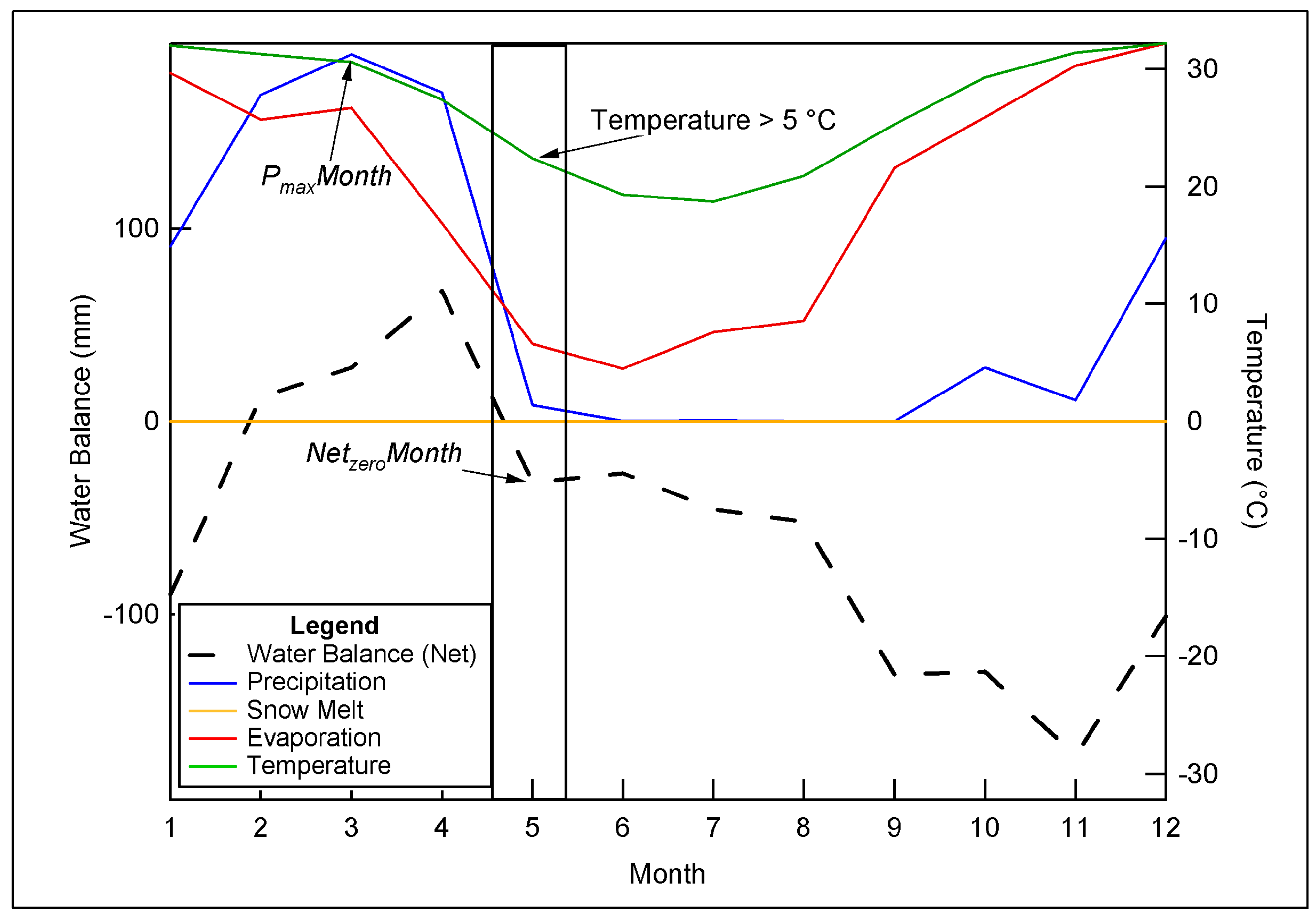
2.2. Methods (Algorithm Description)
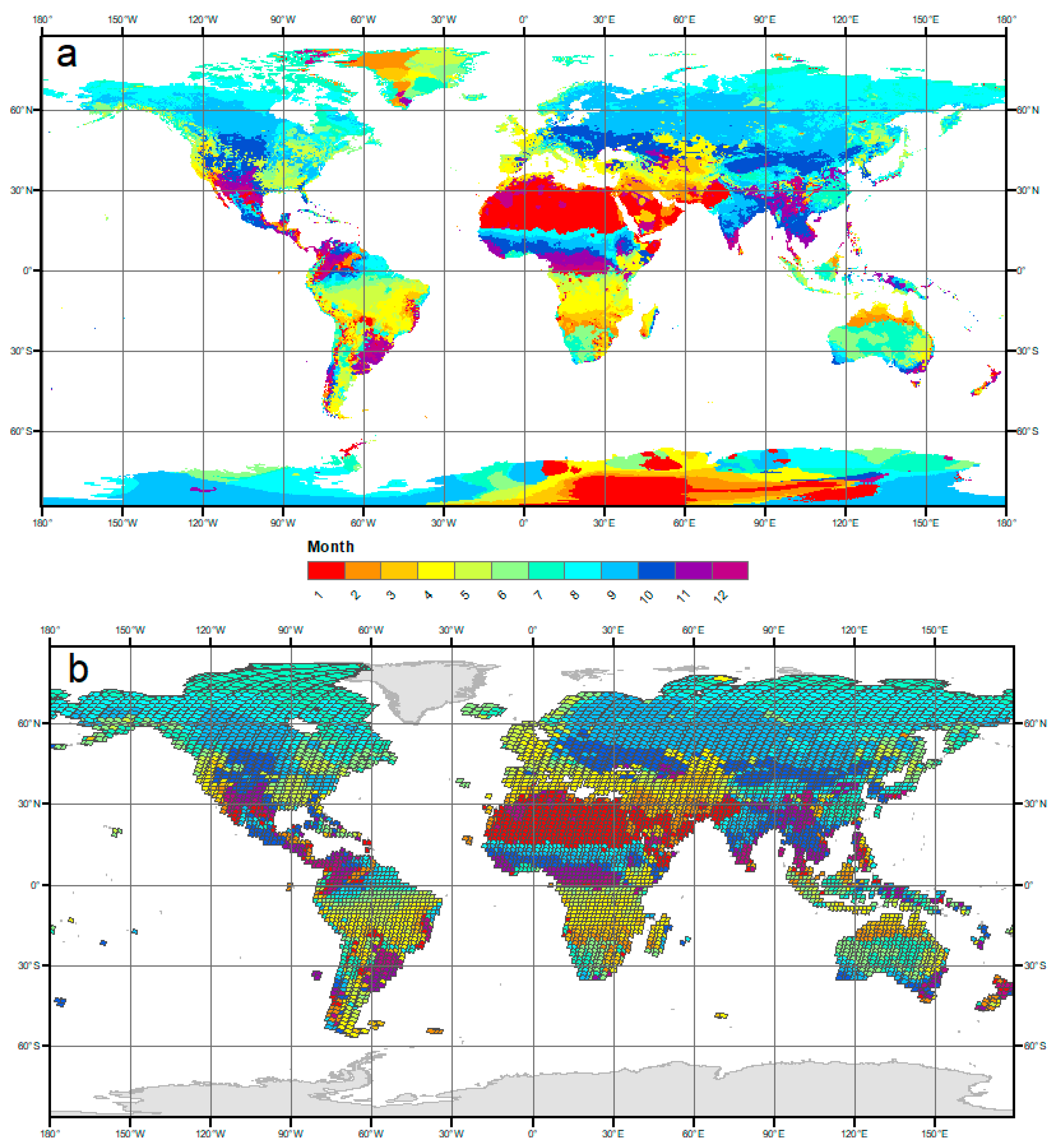
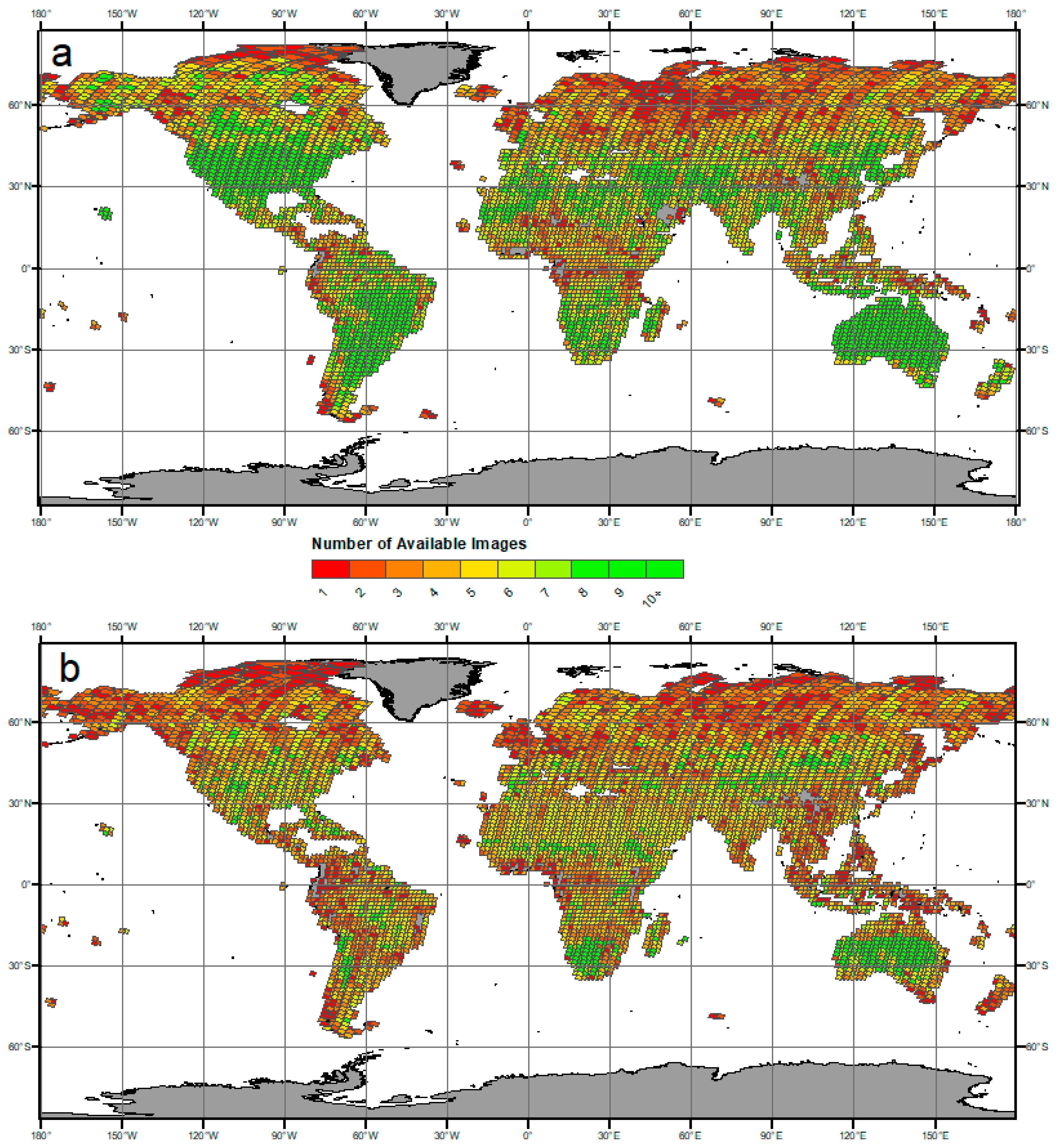
3. Results
4. Discussion
5. Conclusions
Acknowledgments
Author Contributions
Conflicts of Interest
References
- Carpenter, S.R.; Fisher, S.G.; Grimm, N.B.; Kitchell, J.F. Global Change and Fresh-Water Ecosystems. Annu. Rev. Ecol. Syst. 1992, 23, 119–139. [Google Scholar] [CrossRef]
- Vorosmarty, C.J. Global Water Resources: Vulnerability from Climate Change and Population Growth. Science 2000, 289, 284–288. [Google Scholar] [CrossRef] [PubMed]
- Downing, J.A.; Prairie, Y.T.; Cole, J.J.; Duarte, C.M.; Tranvik, L.J.; Striegl, R.G.; McDowell, W.H.; Kortelainen, P.; Caraco, N.F.; Melack, J.M.; et al. The global abundance and size distribution of lakes, ponds, and impoundments. Limnol. Oceanogr. 2006, 51, 2388–2397. [Google Scholar] [CrossRef]
- Eagleson, P.S. The emergence of global-scale hydrology. Water Resour. Res. 1986, 22, 6S–14S. [Google Scholar] [CrossRef]
- Alsdorf, D.E.; Rodriguez, E.P.; Lettenmaier, D.P. Measuring surface water from space. Rev. Geophys. 2007, 45, 24. [Google Scholar] [CrossRef]
- United States Geological Survey (USGS). Landsat Updates. Available online: http://landsat.usgs.gov/about_Landsat_Updates.php (accessed on 1 May 2016).
- Lehner, B.; Döll, P. Development and validation of a global database of lakes, reservoirs and wetlands. J. Hydrol. 2004, 296, 1–22. [Google Scholar] [CrossRef]
- Frey, K.E.; Smith, L.C. How well do we know northern land cover? Comparison of four global vegetation and wetland products with a new ground-truth database for West Siberia. Glob. Biogeochem. Cycles 2007, 21. [Google Scholar] [CrossRef]
- Verpoorter, C.; Kutser, T.; Seekell, D.A.; Tranvik, L.J. A global inventory of lakes based on high-resolution satellite imagery. Geophys. Res. Lett. 2014, 41, 6396–6402. [Google Scholar] [CrossRef]
- Verpoorter, C.; Kutser, T.; Tranvik, L.J. Automated mapping of water bodies using Landsat multispectral data. Limnol. Oceanogr. Methods 2012, 10, 1037–1050. [Google Scholar] [CrossRef]
- Yamazaki, D.; Trigg, M.A.; Ikeshima, D. Development of a global ~90 m water body map using multi-temporal Landsat images. Remote Sens. Environ. 2015, 171, 337–351. [Google Scholar] [CrossRef]
- Gutman, G.; Huang, C.; Chander, G.; Noojipady, P.; Masek, J.G. Assessment of the NASA-USGS Global Land Survey (GLS) datasets. Remote Sens. Environ. 2013, 134, 249–265. [Google Scholar] [CrossRef]
- Pekel, J.-F.; Cottam, A.; Gorelick, N.; Belward, A.S. High-resolution mapping of global surface water and its long-term changes. Nature 2016, 540, 418–422. [Google Scholar] [CrossRef] [PubMed]
- Tatem, A.J.; Nayar, A.; Hay, S.I. Scene selection and the use of NASA’s global orthorectified Landsat dataset for land cover and land use change monitoring. Int. J. Remote Sens. 2006, 27, 3073–3078. [Google Scholar] [CrossRef] [PubMed]
- Khatib, L.; Morris, R.A.; Gasch, J. Local Search for Optimal Global Map Generation Using Mid-Decadal Landsat Images. AI Mag. 2009, 30, 84. [Google Scholar] [CrossRef]
- Khorram, S. Accuracy Assessment of Remote Sensing-Derived Change Detection; Monograph Series; American Society for Photogrammetry and Remote Sensing: Bethesda, MD, USA, 1999. [Google Scholar]
- Justice, C.O.; Townshend, J.R.G.; Holben, B.N.; Tucker, C.J. Analysis of the Phenology of Global Vegetation using Meteorological Satellite Data. Int. J. Remote Sens. 1985, 6, 1271–1318. [Google Scholar] [CrossRef]
- Linderman, M.; Rowhani, P.; Benz, D.; Serneels, S.; Lambin, E.F. Land-cover change and vegetation dynamics across Africa. J. Geophys. Res. 2005, 110. [Google Scholar] [CrossRef]
- Tucker, C.J.; Grant, D.M.; Dykstra, J.D. NASA’s Global Orthorectified Landsat Data Set. Photogramm. Eng. Remote Sens. 2004, 70, 313–322. [Google Scholar] [CrossRef]
- Masek, J.G.; Vermote, E.F.; Saleous, N.E.; Wolfe, R.; Hall, F.G.; Huemmrich, K.F.; Gao, F.; Kutler, J.; Lim, T.-K. A Landsat Surface Reflectance Dataset for North America, 1990–2000. IEEE Geosci. Remote Sens. Lett. 2006, 3, 68–72. [Google Scholar] [CrossRef]
- Robin, J.; Dubayah, R.; Sparrow, E.; Levine, E. Monitoring start of season in Alaska with GLOBE, AVHRR, and MODIS data. J. Geophys. Res. Biogeosci. 2008, 113, 1–10. [Google Scholar] [CrossRef]
- Willmott, C.J.; Feddema, J. A more rational climatic moisture index. Prof. Geogr. 1992, 44, 84–88. [Google Scholar] [CrossRef]
- Lyons, E.A.; Sheng, Y.; Smith, L.C.; Li, J.; Hinkel, K.M.; Lenters, J.D.; Wang, J. Quantifying sources of error in multitemporal multisensor lake mapping. Int. J. Remote Sens. 2013, 34, 7887–7905. [Google Scholar] [CrossRef]
- Justice, C.O.; Markham, B.L.; Townshend, J.R.G.; Kennard, R.L. Spatial degradation of satellite data. Int. J. Remote Sens. 1989, 10, 1539–1561. [Google Scholar] [CrossRef]
- Roy, D.P.; Wulder, M.A.; Loveland, T.R.; Woodcock, C.E.; Allen, R.G.; Anderson, M.C.; Helder, D.L.; Irons, J.R.; Johnson, D.M.; Kennedy, R. Landsat-8: Science and product vision for terrestrial global change research. Remote Sens. Environ. 2014, 145, 154–172. [Google Scholar] [CrossRef]
- Goward, S.N.; Arvidson, T.; Williams, D.; Faundeen, J.; Irons, J.R.; Franks, S. Historical record of Landsat global coverage: Mission operations, NSLRSDA, and international cooperator stations. Photogramm. Eng. Remote Sens. 2006, 72, 1155–1169. [Google Scholar] [CrossRef]
- Williams, D.L.; Goward, S.N.; Arvidson, T. Landsat: Yesterday, today, and tomorrow. Photogramm. Eng. Remote Sens. 2006, 72, 1171–1178. [Google Scholar] [CrossRef]
- Arvidson, T.; Gasch, J.; Goward, S.N. Landsat 7’s long-term acquisition plan—An innovative approach to building a global imagery archive. Remote Sens. Environ. 2001, 78, 13–26. [Google Scholar] [CrossRef]
- Sheng, Y.; Song, C.; Wang, J.; Lyons, E.A.; Knox, B.R.; Cox, J.S.; Gao, F. Representative lake water extent mapping at continental scales using multi-temporal Landsat-8 imagery. Remote Sens. Environ. 2016. [Google Scholar] [CrossRef]
- Willmott, C.J.; Matsuura, K. Terrestrial Air Temperature and Precipitation: Monthly and Annual Climatologies (Version 3.02). 2001. Available online: http://climate.geog.udel.edu/~climate/html_pages/README.ghcn_clim2.html. (Accessed on 3 November 2014).
- Willmott, C.J.; Matsuura, K. Terrestrial Water Balance Data Archive: Regridded Monthly Climatologies (Version 1.02). 2001. Available online: http://climate.geog.udel.edu/~climate/html_pages/README.wb2.html. (Accessed on 3 November 2014).
- Willmott, C.J.; Rowe, C.M.; Mintz, Y. Climatology of the Terrestrial Seasonal Water Cycle. J. Climatol. 1985, 5, 589–606. [Google Scholar] [CrossRef]
- United States Geological Survey (USGS). The Website of the Land Processes Distributed Active Archive Center (LP DAAC). Available online: https://landsat.usgs.gov/landsat-bulk-metadata-service (accessed on 20 March, 2015).
- Irons, J.R.; Dwyer, J.L.; Barsi, J.A. The next Landsat satellite: The Landsat data continuity mission. Remote Sens. Environ. 2012, 122, 11–21. [Google Scholar] [CrossRef]
- Pavelsky, T.M.; Smith, L.C. RivWidth: A software tool for the calculation of river widths from remotely sensed imagery. Geosci. Remote Sens. Lett. IEEE 2008, 5, 70–73. [Google Scholar] [CrossRef]
- Gleason, C.J.; Smith, L.C. Toward global mapping of river discharge using satellite images and at-many-stations hydraulic geometry. Proc. Natl. Acad. Sci. USA 2014, 111, 4788–4791. [Google Scholar] [CrossRef] [PubMed]
- Hansen, M.C.; Potapov, P.V.; Moore, R.; Hancher, M.; Turubanova, S.; Tyukavina, A.; Thau, D.; Stehman, S.V.; Goetz, S.J.; Loveland, T.R.; et al. High-resolution global maps of 21st-century forest cover change. Science 2013, 342, 850–853. [Google Scholar] [CrossRef] [PubMed]
- Kottek, M.; Grieser, J.; Beck, C.; Rudolf, B.; Rubel, F. World map of the Köppen-Geiger climate classification updated. Meteorol. Z. 2006, 15, 259–263. [Google Scholar] [CrossRef]
- Hand, E. Startup liftoff. Science 2015, 348, 172–177. [Google Scholar] [CrossRef] [PubMed]
- ESA Copernicus Space Component Data Access. Available online: https://spacedata.copernicus.eu/ (accessed on 1 January 2017).


| OLI | ||||
| Region | Tiles with ≥1 Image | Total Tiles | % of Tiles w/ ≥1 Image | % of Area Covered |
| Global | 7939 | 9244 | 86% | 98% |
| USA | 659 | 726 | 91% | 100% |
| North America | 1801 | 2108 | 85% | 99% |
| South America | 745 | 820 | 91% | 94% |
| Africa | 1265 | 1327 | 95% | 98% |
| Middle East | 193 | 197 | 98% | 100% |
| Europe | 562 | 622 | 90% | 99% |
| Asia | 1790 | 3323 | 84% | 98% |
| Australia/Oceania | 714 | 874 | 82% | 97% |
| ETM+ | ||||
| Region | Tiles with ≥1 Image | Total Tiles | % of Tiles w/ ≥1 Image | % of Area Covered |
| Global | 7939 | 9244 | 86% | 98% |
| USA | 678 | 726 | 93% | 100% |
| North America | 1892 | 2108 | 90% | 100% |
| South America | 721 | 820 | 90% | 98% |
| Africa | 1264 | 1327 | 88% | 99% |
| Middle East | 166 | 197 | 95% | 84% |
| Europe | 577 | 622 | 93% | 100% |
| Asia | 2822 | 3323 | 85% | 99% |
| Australia/Oceania | 741 | 874 | 85% | 98% |
© 2017 by the authors. Licensee MDPI, Basel, Switzerland. This article is an open access article distributed under the terms and conditions of the Creative Commons Attribution (CC BY) license (http://creativecommons.org/licenses/by/4.0/).
Share and Cite
Lyons, E.A.; Sheng, Y. LakeTime: Automated Seasonal Scene Selection for Global Lake Mapping Using Landsat ETM+ and OLI. Remote Sens. 2018, 10, 54. https://doi.org/10.3390/rs10010054
Lyons EA, Sheng Y. LakeTime: Automated Seasonal Scene Selection for Global Lake Mapping Using Landsat ETM+ and OLI. Remote Sensing. 2018; 10(1):54. https://doi.org/10.3390/rs10010054
Chicago/Turabian StyleLyons, Evan A., and Yongwei Sheng. 2018. "LakeTime: Automated Seasonal Scene Selection for Global Lake Mapping Using Landsat ETM+ and OLI" Remote Sensing 10, no. 1: 54. https://doi.org/10.3390/rs10010054
APA StyleLyons, E. A., & Sheng, Y. (2018). LakeTime: Automated Seasonal Scene Selection for Global Lake Mapping Using Landsat ETM+ and OLI. Remote Sensing, 10(1), 54. https://doi.org/10.3390/rs10010054