Article

Tree Death Not Resulting in Gap Creation: An Investigation of Canopy Dynamics of Northern Temperate Deciduous Forests

by
Jean-Francois Senécal
1,2,*,
Frédérik Doyon
2 and
Christian Messier
1,2
1
Centre D’étude de la Forêt, Département des Sciences Biologiques, Université du Québec à Montréal, Montréal, QC H3C 3P8, Canada
2
Institut des Sciences de la Forêt Tempérée (ISFORT), Département des Sciences Naturelles, Université du Québec en Outaouais, Ripon, QC J0V 1V0, Canada
*
Author to whom correspondence should be addressed.
Remote Sens. 2018, 10(1), 121; https://doi.org/10.3390/rs10010121
Submission received: 15 November 2017 / Revised: 9 January 2018 / Accepted: 15 January 2018 / Published: 17 January 2018
(This article belongs to the Special Issue Lidar for Forest Science and Management)

Abstract

:
Several decades of research have shown that canopy gaps drive tree renewal processes in the temperate deciduous forest biome. In the literature, canopy gaps are usually defined as canopy openings that are created by partial or total tree death of one or more canopy trees. In this study, we investigate linkages between tree damage mechanisms and the formation or not of new canopy gaps in northern temperate deciduous forests. We studied height loss processes in unmanaged and managed forests recovering from partial cutting with multi-temporal airborne Lidar data. The Lidar dataset was used to detect areas where canopy height reduction occurred, which were then field-studied to identify the tree damage mechanisms implicated. We also sampled the density of leaf material along transects to characterize canopy structure. We used the dataset of the canopy height reduction areas in a multi-model inference analysis to determine whether canopy structures or tree damage mechanisms most influenced the creation of new canopy gaps within canopy height reduction areas. According to our model, new canopy gaps are created mainly when canopy damage enlarges existing gaps or when height is reduced over areas without an already established dense sub-canopy tree layer.

Graphical Abstract

1. Introduction

In the temperate deciduous forest biome, the gap regime is characterized by the creation of relatively small gaps [1]. These openings, called canopy gaps, provide micro-environmental conditions, particularly light [2], necessary for the establishment and growth of trees. They are created by the death or injury of one to several trees [3], in comparison to canopy openings maintained by edaphic factors [4]. It is widely accepted that tree death in a forest is associated with the creation of a canopy gap. This assumption is implicitly prevalent in the literature because there is rarely acknowledgement that tree death does not always create a gap in the canopy (e.g., [5,6,7]). Canopy height loss without canopy gap creation is a phenomenon that has been reported in the literature as a potential concern when estimating gap dynamics properties [8,9] but has not received much attention. However, Senecal et al. [10] have shown, using multi-temporal Lidar (Light Detection and Ranging) data, that height reduction in the canopy left residual heights above what is usually considered a gap by most definitions—a process that [10] called canopy height erosion. Canopy height erosion was more frequent and covered more area than the creation of new canopy gaps in managed and unmanaged forests. They hypothesized that their result was possible only if sub-canopy trees were preserved following canopy tree damages. Such phenomenon would be difficult to observe from the ground, which might explain the absence of studies considering this issue. Yet, even recent studies investigating gap dynamics using multi-temporal Lidar data have not taken canopy height erosion into account (e.g., [11,12,13,14]). Because of that, there is very little knowledge even on what causes canopy height erosion.
Mechanisms of tree death can be of varying incidence and frequency depending on the sources and intensity of the disturbances [15]. Large-scale exogenous disturbances, such as windstorms, droughts, or ice storms can suddenly impact large swaths of forest [16,17,18,19,20,21,22]. Such events, though usually rare, can uproot trees, break boles, and branches, create larger gaps [23], change light distribution [24], and generally have a greater effect on forest structure than endogenous disturbances [25]. On the other hand, endogenous disturbances will affect one or more trees and are generally much less sudden, producing gradual changes in micro-environments. Gradual tree death has been shown to be frequent in some northern hardwood forests [26]. It is understood that sudden and gradual tree death may have very different ecological repercussions on forest communities [27].
Understanding the relation between canopy structure and gap dynamics is important because it is the background against which gaps are evaluated. After all, canopy gaps are only one of many types of canopy structural components [28]. Canopy structure is the organization in space or time of the aboveground components of vegetation [29]. Despite its importance, canopy structure is rarely described in detail in gap studies, or it is described using definitions and attributes that are themselves imprecise. The canopy can be partitioned in several layers with or without vegetation, which, when combined, define many types of canopy structure, amongst which we find sub-canopy gaps and the traditional canopy gap [30]. Clearly, the usage of a simplistic dichotomous canopy gap definition does not account for certain phenomena that happen in the canopy [31], and may mask the importance of other processes [8,10].
Two possible general explanations for the creation of canopy gaps seem to be evident. The first is a process-based explanation where tree damage mechanisms responsible for canopy height reduction destroy the sub-canopy vegetation, while other mechanisms protect or even stimulate its growth. The second is a structure-based explanation and is inspired by the work of [29], where the absence of gaps is independent of the tree damage mechanism, but rather related to the three-dimensional (3D) structure of the canopy and the sub-canopy. Specific types of canopy/sub-canopy structures would lead to different outcomes in the event of tree damage that would generate a canopy height reduction. Following canopy height reduction, a gap will be created when there are no sub-canopy trees. Otherwise, we have canopy height erosion.
The objectives of this study were to determine (1) the tree damage mechanisms responsible for canopy height reduction, (2) whether gap creation is linked to specific tree damage mechanisms responsible for canopy height reduction or to the pre-existing canopy/sub-canopy structure, and (3) the conditions conducive to canopy height erosion or new canopy gaps, following canopy height reduction.

2. Materials and Methods

2.1. Study Area

The study area was located in the temperate deciduous forest biome in southern Quebec, Canada. The unmanaged and managed forest stands were situated in the Forêt-la-Blanche preserve (45°44′N, 75°16′W) and the Papineau-Labelle fauna preserve (45°59′N, 75°20′W), respectively. One additional unmanaged forest stand was also located in the Papineau-Labelle fauna preserve. There were no indications of disturbances that were caused by humans in the unmanaged forest stands. The managed forest stands were subjected to partial cutting in 1993, 2000, or 2004. Partial cuts in managed stands as they are performed in Quebec involve the removal of about a third of the basal area [32]. No forms of management were performed and no major natural disturbances occurred in any of the stands between 2007 and 2013. The prevalent tree species that were found in the stands are sugar maple (Acer saccharum Marsh.), American beech (Fagus grandifolia Ehrh.), red maple (Acer rubrum L.), basswood (Tilia americana L.), eastern hemlock (Tsuga canadensis (L.) Carrière), and white ash (Fraxinus americana). Ironwood (Ostrya virginiana (Mill.) K. Koch) and striped maple (Acer pensylvanicum L.) are commonly found in gaps. All sites were chosen to be as similar as possible in terms of species composition, stand structure and abiotic attributes. Tree density was not measured in the sites, nor was the extent of logging in 1993, 2000, or 2004 for the managed sites. Mean heights in 2007 of the unmanaged and managed sites cut in 1993, 2000 and 2004 were respectively 16.3 m, 15.2 m, 14.3 m, and 14.0 m. Average annual temperature varies between 2.5 °C and 5.0 °C [33]. Many trees in the study area were damaged during the North American ice storm of 1998. Trees received between 40 and 100 mm of ice due to freezing rain, causing light to severe damage to the trees in this study area [34]. Beech bark disease [35] has been present for several years, resulting in the mortality of large beeches in the study area. Both these disturbances have led to the establishment of a dense layer of regeneration, many of them beeches, which have since grown to sapling or pole size.

2.2. Lidar Data Processing

Two Lidar datasets were acquired for this study (Table 1). Preprocessing of the dataset was done using the Terrascan software package (Terrasolid, Leppävaara, Finland). This treatment involved bird hits removal, data cleaning, and the classification of the Lidar points to separate ground points.
Height models were generated following accepted procedures for multi-temporal Lidar data [36]. The Lidar data from the two acquisitions were co-registered to find potential systematic planimetric errors. After none were found, the ground hits were combined and were used to create a 50 cm resolution digital terrain model. The lowest ground point value was assigned to each pixel of the height model. Pixels without ground hits were filled by inverse distance weighted interpolation. The interpolation was done with the merged ground hits and an inverse distance power of 2. The digital surface models were completed using the same process, but separately for the 2007 and 2013 data, and with the highest non-ground hit points in each pixel. The canopy height models (CHM) were then produced by subtracting the digital terrain model from the 2007 and 2013 digital surface models. The 2007 CHM was subtracted from the 2013 CHM to produce the height change model. Positive values of the height change model mean growth and negative values mean canopy height reduction during the study period. Generation of height models was done in SAGA-GIS 2.2.3 [37].
We detected height reduction areas (HRA) as groups of pixels where a reduction of a minimum of 1 m in height between 2007 and 2013 was observed. To form a HRA, the cluster had to be at least 5 m2 in size (Figure 1). This definition is similar to methods to detect canopy gaps, although it is not contingent on a specific height threshold. Its purpose is strictly to detect areas of canopy height loss. Within HRA, new gap pixels were detected as 2013 CHM pixels in the HRA of height 3 m or less, and for 2007 heights higher than 3 m, whereas canopy height erosion pixels were detected as 2013 CHM pixels of height more than 3 m high after height loss. This detection threshold was chosen when considering that a higher threshold would result in small sub-canopy trees or shrubs being considered as gaps [11]. Furthermore, a lower threshold might have allowed for some seedlings to grow vertically over the height threshold during the study period if canopy opening occurred soon after the 2007 Lidar acquisition. With that 3 m gap detection threshold, 94% of the HRA surface was occupied by canopy height erosion and 6% by new canopy gaps [10].

2.3. Field Sampling

Prior to fieldwork, sampling plots were delimited in the managed and unmanaged forest stands (9 in total, 100 m × 100 m each) in a geographic information system. The plots were located on homogeneous topography as much as possible. Fieldwork was conducted during the summer of 2014. We visited as many HRA as we could find within the plots and took extensive notes and photographs. A total of 178 HRA were visited in which we tried to identify visually the mechanisms that could have been responsible for height reductions large enough to be detected with the LiDAR data. We identified five tree damage mechanisms during fieldwork, which are branch breakage, tree bole breakage, tree uprooting, tree dying while standing, and tree bending. We did not go further than the damage mechanism, such as trying to identify tree disease or abiotic conditions. Each HRA could have more than one kind of damage mechanism and could have multiple trees with the same damage mechanism. We did not measure HRA or gap size in the field.
Twenty-two HRA (12%) were not considered because we were not able to find a probable height reduction mechanism during fieldwork. We also performed quality control of the dataset. This step was necessary because it was difficult to delineate the HRA boundaries in the field from below the canopy, even though we had the maps within a GPS. Using our notes, we identified HRA with incomplete data. The missing data was usually due to our being unable to find height reduction mechanisms in some portions of HRA. This happened for some large HRA, and in HRA with heights of residual trees over 10 m high. This led to the removal of another 32 HRA, so that the final dataset contained 124 HRA.
We also sampled the ground layer and understory structure along 100 m transects in one unmanaged site and one managed site cut in 1993. This step was initially done to verify if the 2007 and 2013 Lidar point cloud datasets could be reliably used to describe the sub-canopy structure, especially when there was vegetative material in the overstory. The two transects were part of an initiative to describe canopy stratification change over a range of time following partial cuttings. We established 100 m long transects by randomly choosing a starting location in each site. A Thales ProMark3 precision GPS (Magellan, San Dimas, CA, USA) with an external antenna was set up at this location. We then positioned rods every 10 m, using a Vertex III and T3 transponder (Haglöf Sweden AB, Långsele, Sweden) to measure distance, and used previous rods or the first GPS station for alignment to ensure we continued in a straight line. A second GPS of the same model was set at the end of the transect. The sampling units were delimited as 5 m × 5 m squares along the two transects. Within these squares, we visually estimated the percentage of leaf cover in 1-meter height increments. The estimation was performed entirely by the same two workers using a reference sheet with example patterns of leaf coverage with percentages associated. We used an SK-202 height measuring rod (SK-Senshin, Osaka, Japan) to partition vertical space accurately. As the rod had a maximum height measure of 8 m, we could only reliably measure percent leaf cover up to 10 m. Each GPS recorded location data for over 1 h. GPS data were post-processed using GNSS solutions (Magellan). Post-processing assessment of precision showed that the distance between the two GPS locations were distant by 100.80 m for the unmanaged forest and 101.72 m for the managed forest. Lidar point density was 3.8 points/m2 and 6.8 points/m2 for the unmanaged forest transect in 2007 and 2013, and 6.4 points/m2 and 8.0 points/m2 for the managed forest in 2007 and 2013, respectively. The higher 2007 point density of the managed forest site as compared to the unmanaged forest is because the former was located on overlapping flight lines coverage, thus increasing the local point density.
We evaluated the correspondence between leaf cover density field data and Lidar point density using Kendall’s Tau-b rank correlation coefficient. We identified distinct canopy layers in the transect data visually using the Lidar data and the field data to determine presence or absence of trees in each 5 × 5 × 1 m sampling units. We used the classification of [29] for the visual interpretation of vertical stratification. The ground layer was set as heights below 3 m, understory was set as heights between 3 m and below 10 m, mid-canopy was set as heights between 10 m and below 17 m, and upper canopy was set as heights 17 m and above. We then determined whether the canopy top was a single layer structure in the overstory or not. We performed a visual estimation of the number of canopy layers that were occupied by trees using the field data and Lidar data. The complete data used for this is provided in the Annex (Figure A1, Figure A2, Figure A3 and Figure A4). We further distinguished the cases in which there were trees in only one canopy layer, especially if it was the overstory, as those trees are more likely to die than trees in lower parts of the canopy.

2.4. Statistical Analysis
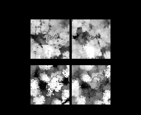
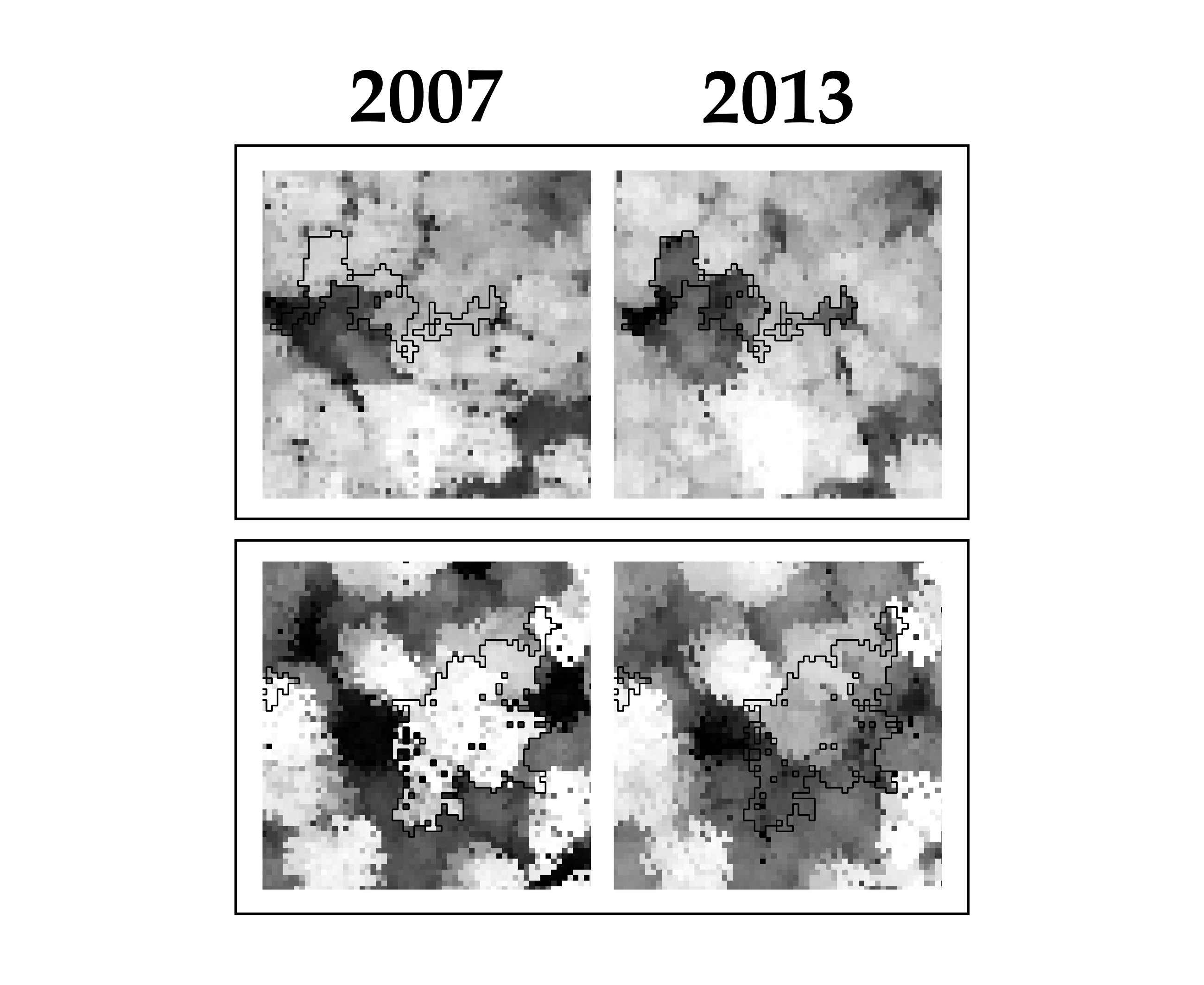
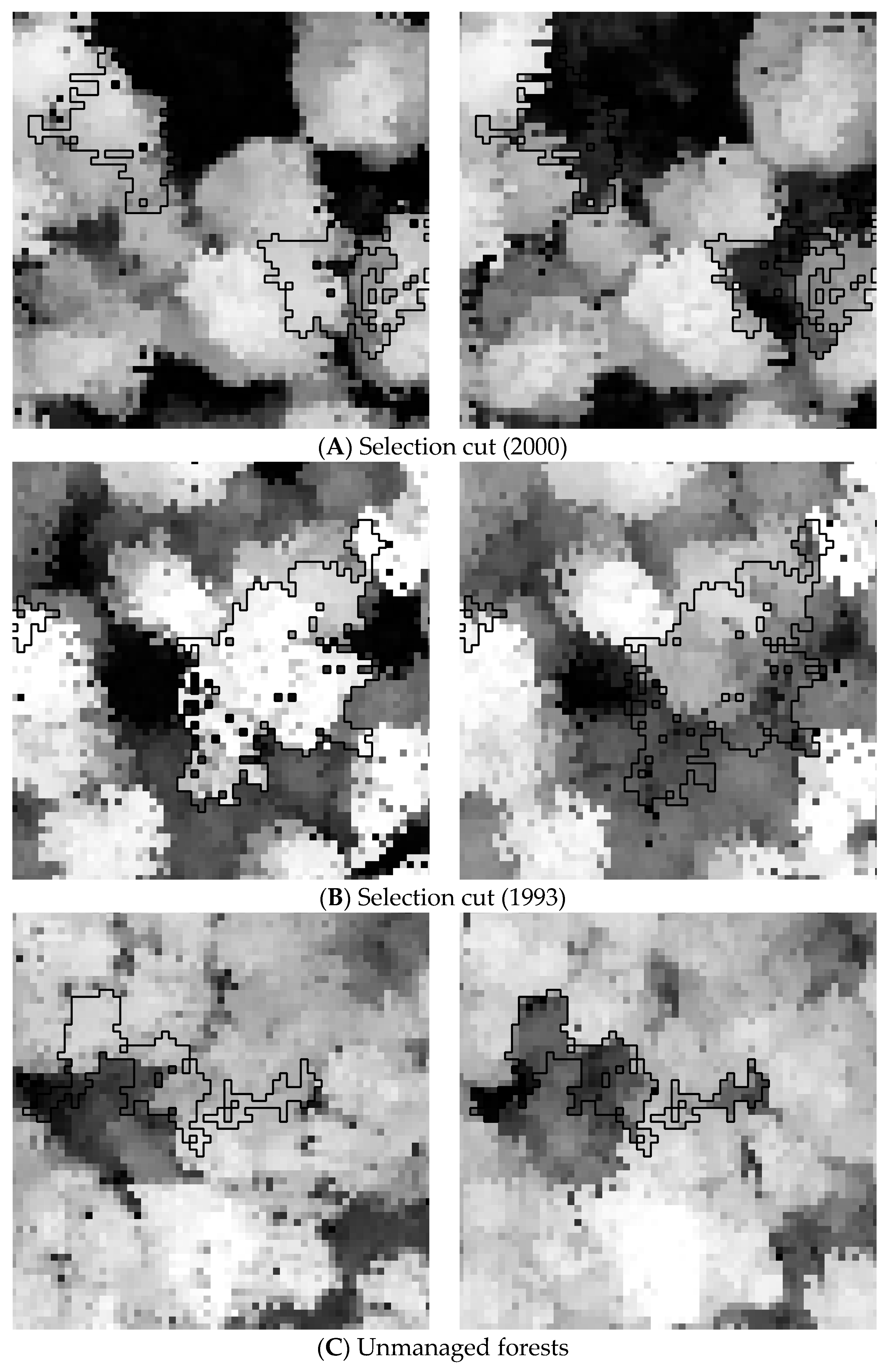
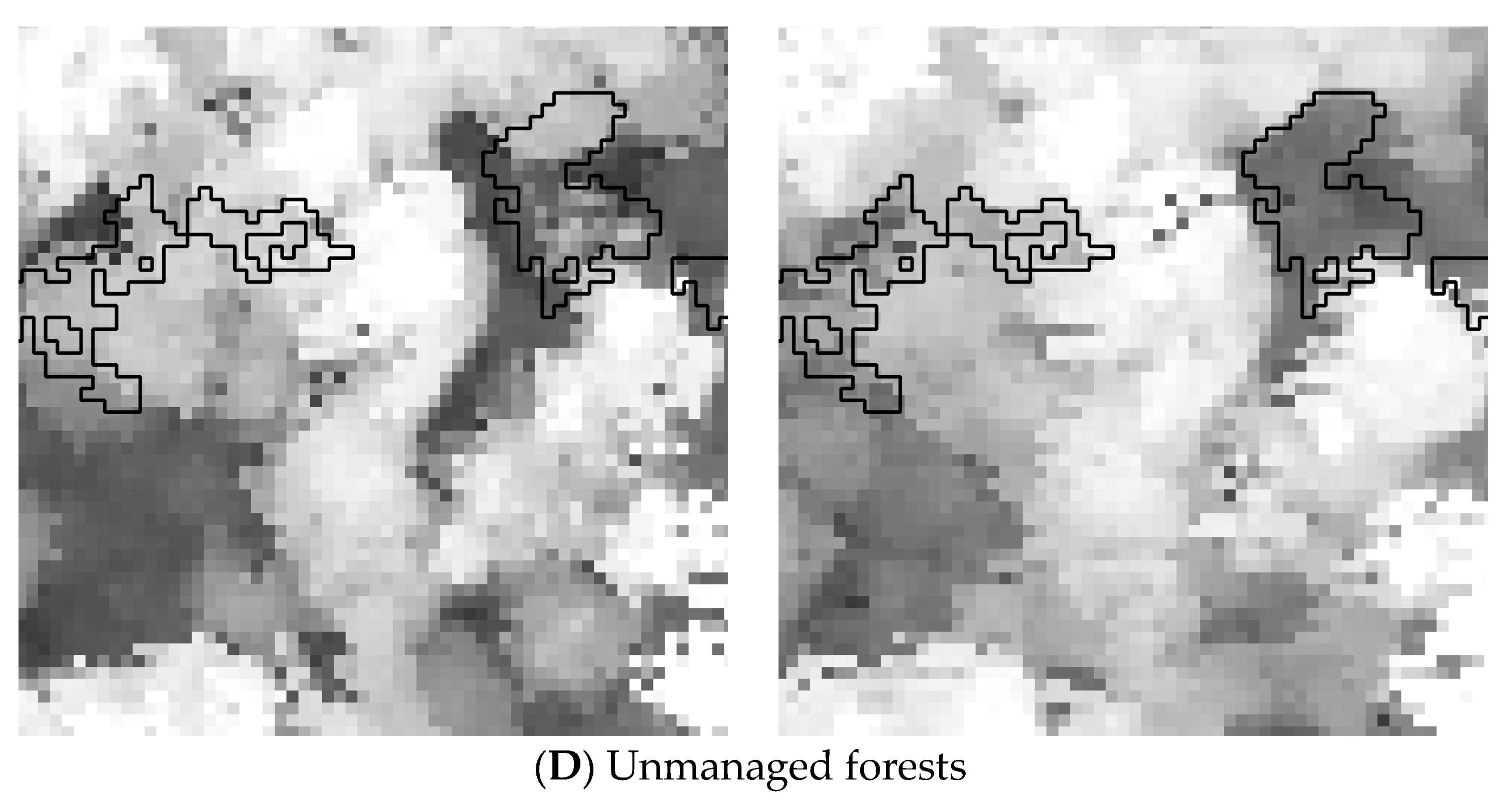
The analysis was conducted using a multi-model inference framework [38]. We built two models to represent how the competing hypotheses could best explain the creation of new canopy gaps within the HRA that were sampled during fieldwork. HRA is the sampling unit for the statistical analyses. We tested two possible models to explain canopy gaps. The first model was assessed using the presence or absence of new canopy gaps, which were detected with the 3-m height threshold and variables indicating whether tree damage mechanisms were found in the HRA (Table 2). This model is called the MECHANISMS model. The uprooted mechanism could not be put in the model because it was too infrequent in the plots. HRA with uprooting were therefore removed from the statistical analysis. The second model was assessed using the area of HRA and the adjacency of HRA to older gaps (i.e., openings with a height equal to or lower than 3 m in 2007). This model is called the STRUCTURE model. Older gaps either remained opened or became closed between 2007 and 2013. We expected that these two variables would be related to sub-canopy structure because larger HRA would have a higher probability of revealing the absence of sub-canopy trees. The older gap adjacency variable was added because we noticed that areas without understory trees were spatially clustered, meaning that the absence of sub-canopy vegetation could extend farther than gap edges under the canopy. The models were constructed using mixed-effects logistic regression models with a logit link. The sites were input as random effects to account for pseudo-replication. The models were then ranked with AICc in R 3.4.0 with the AICcmodavg and lme4 packages. The receiver operating characteristic curve (ROC) and the Nagelkerke’s pseudo-R2 were used to assess the performance of the model [39]. We performed a post-hoc analysis using two-sided Fisher’s exact test on 2 × 2 contingency tables of the frequencies of tree damage mechanisms and gap presence or absence. This was done to find evidence of specific tree damage mechanisms influencing the HRA.

3. Results

3.1. Comparing the Structures and Mechanisms Models

The model with the most support for predicting presence or absence of gaps within HRA was the STRUCTURE model (Table 3). This model received all of the AICc weight, indicating that the MECHANISMS model is very unlikely to explain new gap creation. The site random effect parameter in the STRUCTURE model had a variance of 0; further tests indicated that the random effects parameters were not different between sites—meaning that the mixed-effects model was essentially a regular generalized linear model. As a result, we analyzed the STRUCTURE model as a regular generalized linear model in the next analyses. The area under the ROC curve was 0.88, which indicates that the model has good discriminatory power [39]. The model also had a Nagelkerke’s pseudo R2 index value of 0.49.
The STRUCTURE model equation is:
GAP = −3.58 + AreaHRA × 0.026 + AdjacencyGap × 2.48,
which indicates that larger HRA have a higher chance of having gaps and also that HRA that are adjacent to older gaps also have an increased chance of containing a new gap.

3.2. Tree Damage Mechanisms

There was no major disturbance in the study area between 2007 and 2013. Consequently, indications of sudden or major tree deaths were rarely observed during fieldwork campaigns. Only around 23% of validated HRA had gaps in them at the 3 m height threshold. Among the tree damage mechanisms that were recorded in HRA, the most frequent were, in order of importance, standing dead tree (44%), broken bole and broken branch (both 35%), tree bent (22%), and uprooted tree (3%). Table 4 shows the association between the frequencies of tree damage mechanisms and the presence or absence of canopy gap creation within HRA.

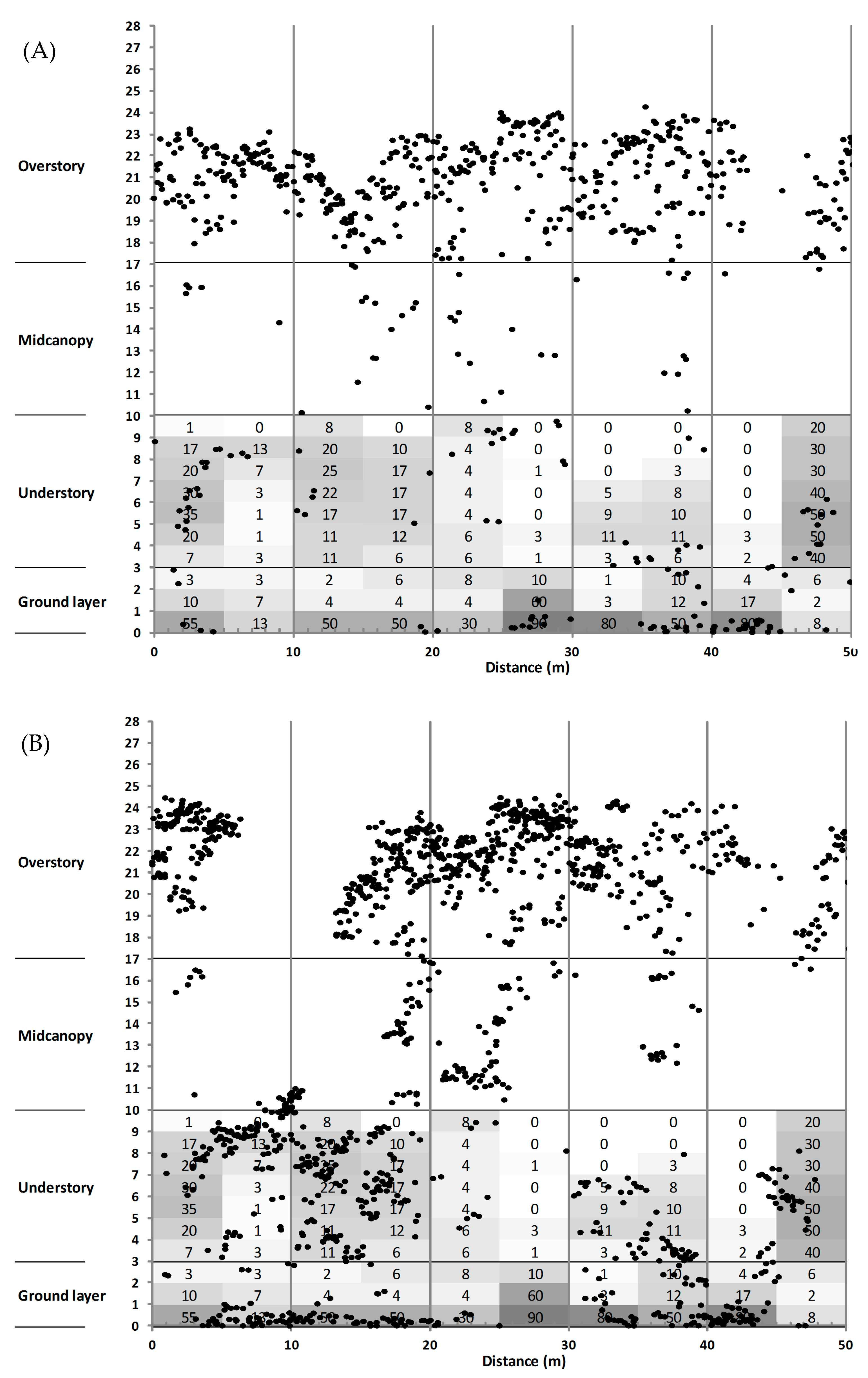
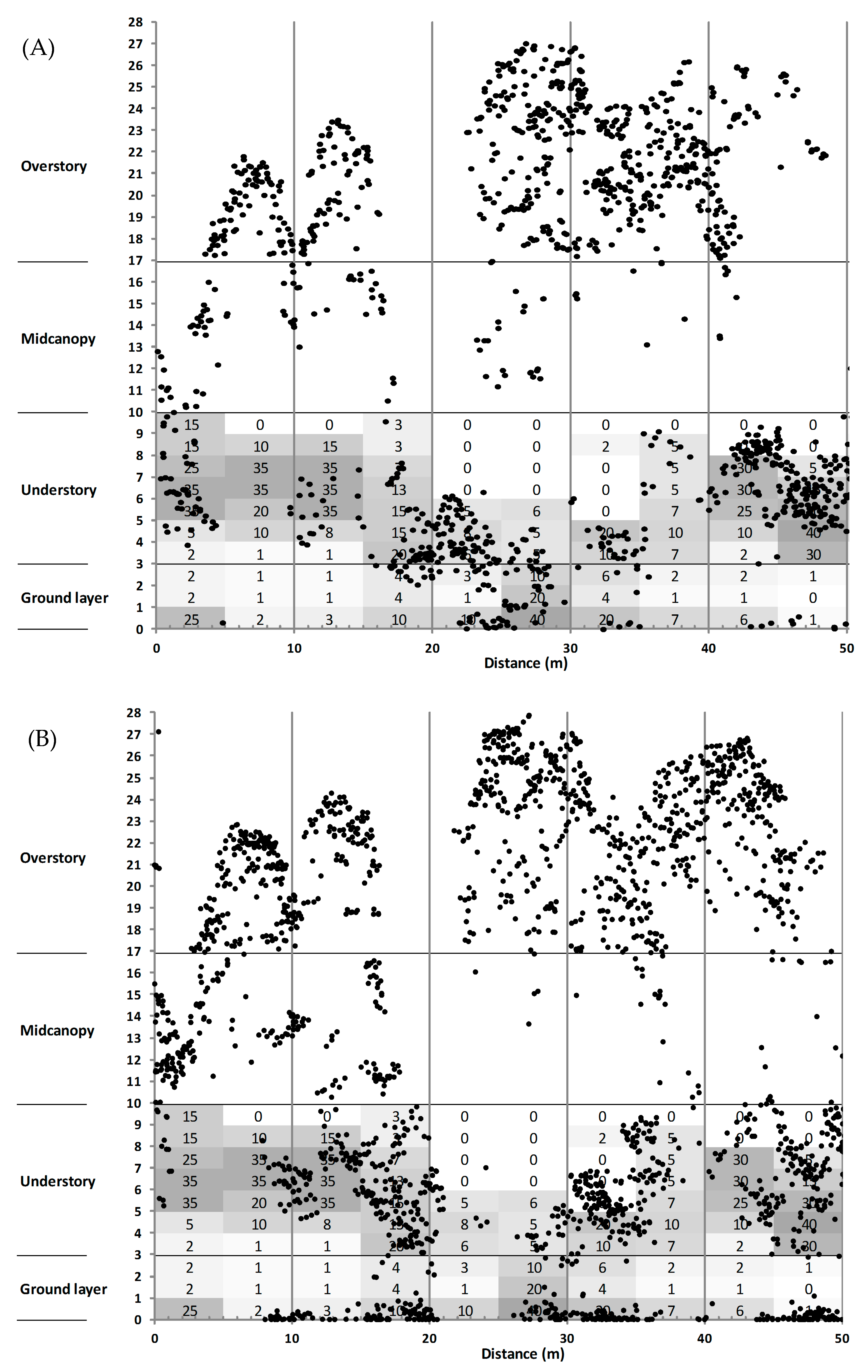
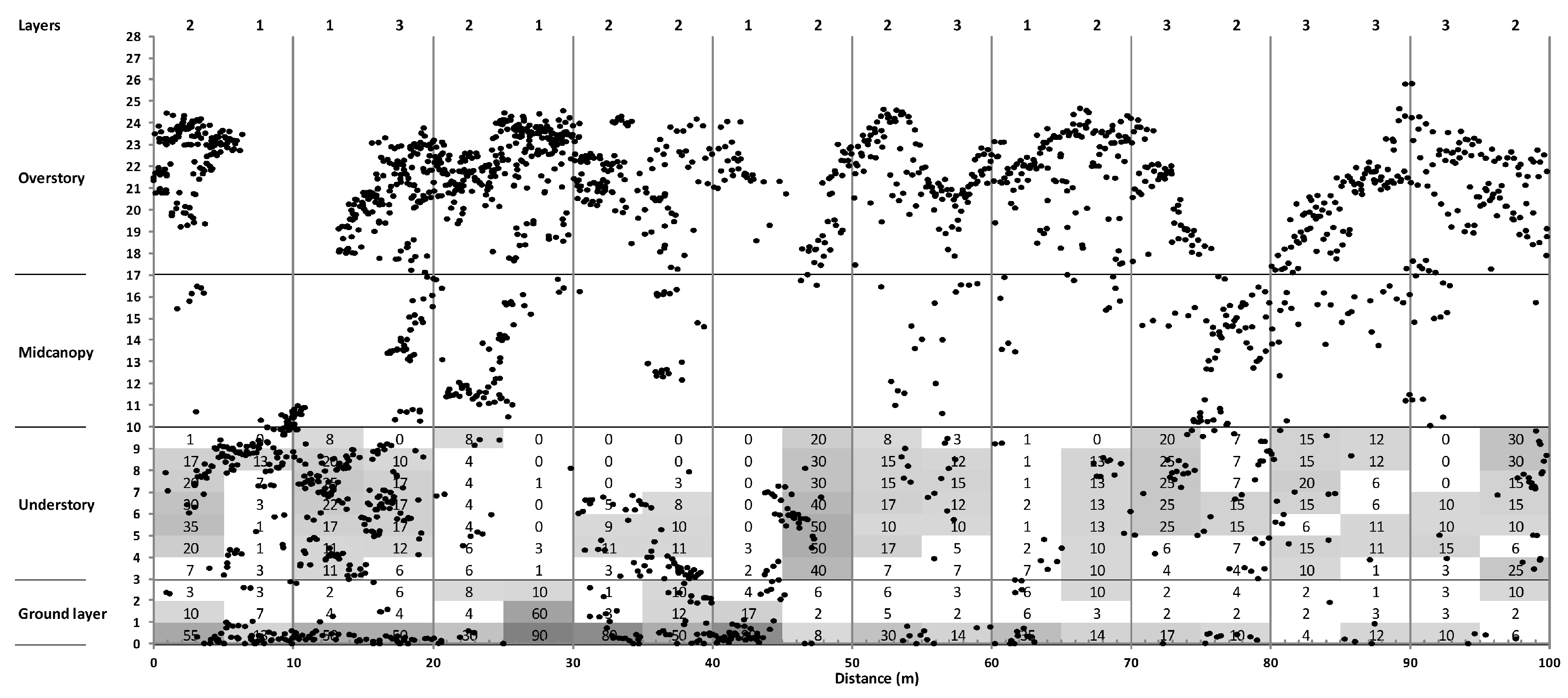
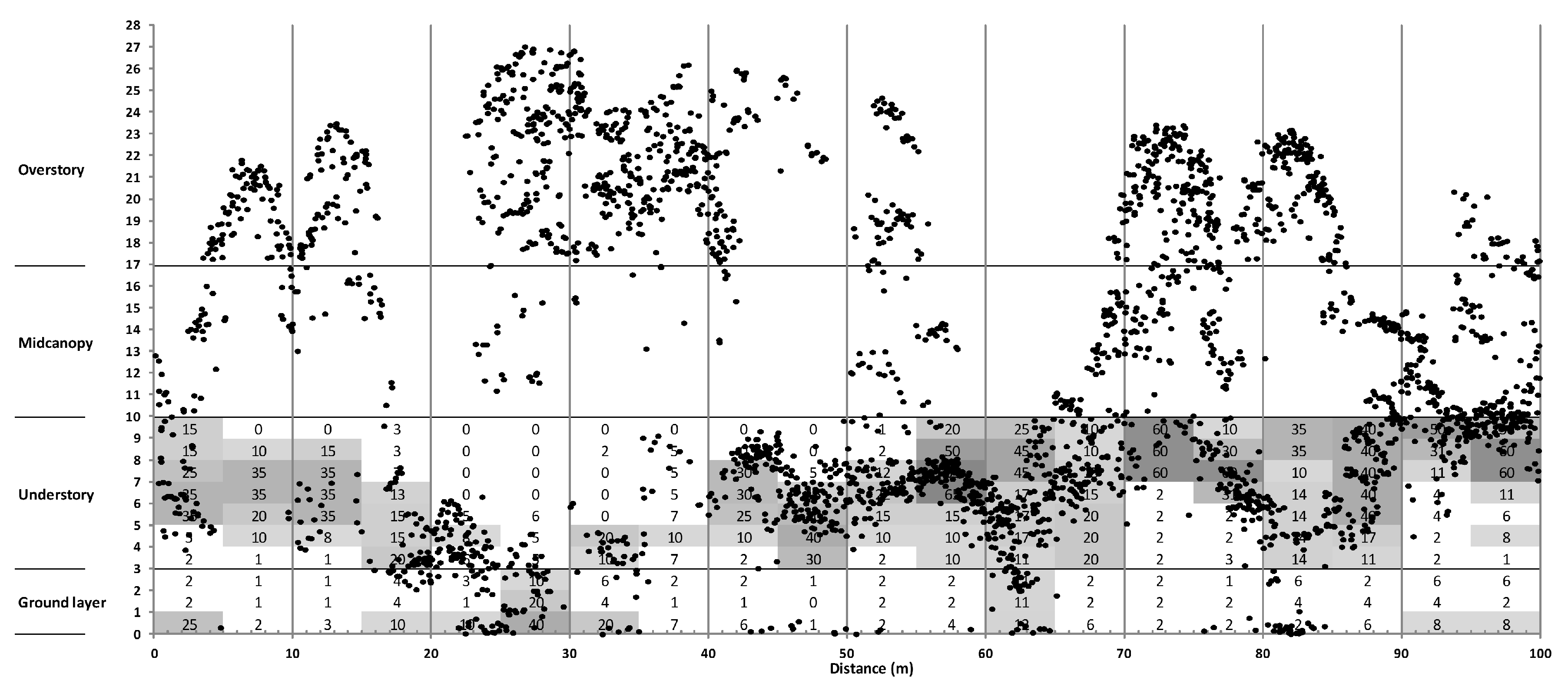
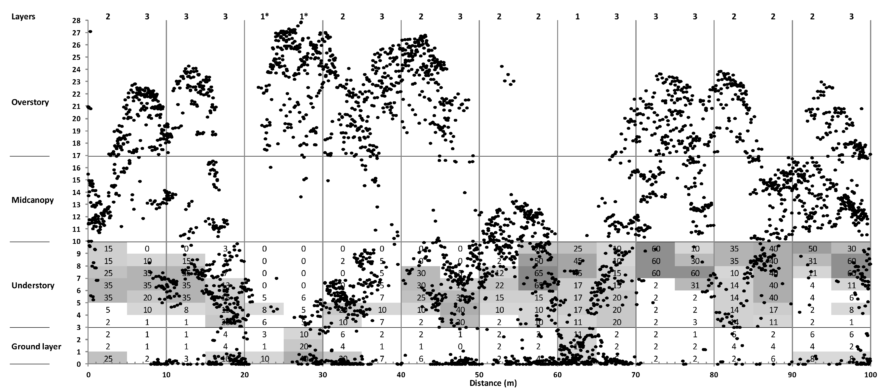
3.3. Canopy Structure

The analysis of rank correlation between Lidar point density and leaf cover field data showed significant positive correlations for the available data in the first 10 m from the forest floor in the unmanaged forest in 2007 (tau = 0.25, p < 0.001) and 2013 (tau = 0.20, p < 0.001), and in the managed forest transect in 2007 (tau = 0.36, p < 0.001) and 2013 (tau = 0.21, p < 0.001). Correlations were higher with the 2007 Lidar data than the 2013 data.
Visual examination of the leaf cover data showed that the 2013 Lidar dataset could be used to detect sub-canopy structure. However, the 2007 Lidar dataset had occlusion issues that might be due to poor canopy penetration by Lidar. This phenomenon is more apparent in the unmanaged forest (Figure 2) than in the managed forest (Figure 3). We could not use the 2007 dataset to detect understory and ground layer structure when the Lidar point density was lower than 6 points/m2. Thus, we only described canopy stratification using the field data and the 2013 Lidar dataset.
Inspection of the point cloud profiles showed that canopy structure was characterized by a heterogeneous and complex leaf distribution that varied over short distances (Figure 2 and Figure 3). Managing the forest by partial cutting promoted complex multi-storied leaf vertical distributions, while a single-layered structure was almost twice as frequent in unmanaged forests (Table 5). A significant proportion (60–66%) of the single-layered structures were from trees in the overstory. By itself, co-occurrence of single-layered structure and HRA can explain new canopy gap frequencies. Indeed, if one multiplies the frequency of HRAs (found in Table 1 of [10] by the frequency of single layer canopy structure in the overstory (from Table 5), we obtain a gap creation rate of 3.6% for the unmanaged and 1.7% for the managed sites. This assumes that the mortality in the overstory is the same as in the mid-canopy and understory, which is unrealistic. The same calculation using single layer canopy structure with the top of trees in the overstory gives a gap creation rate of 2.2% for the unmanaged forest and 1.1% for the 1993 site.

4. Discussion

4.1. Tree Damage Mechanisms

Most tree damage did not result in new gap creation. This was a surprise as our previous fieldwork for characterizing gaps using mono-temporal Lidar data had presented convincing evidence that some tree damage mechanisms often resulted in the destruction of sub-canopy vegetation [40]. Instead, most of the tree damage that occurred during this study period had no noticeable effect on sub-canopy trees.
In our dataset, standing dead trees was the most prevalent tree damage mechanism. Gradual canopy opening is likely to promote the establishment and growth of sub-canopy vegetation [26,41]. Following model selection, we did a post-hoc visual analysis of the tree damage mechanisms with the spatial data of canopy gaps and erosion in order to make better sense of the rejection of the MECHANISMS model. We observed that beech often died standing in clumps due to the effects of beech bark disease and their clumped spatial organization—due in part to their root sprouting ability [42]. These dead beech clumps generated large HRA that created small gaps. Consequently, it appears that gradual tree death, even if it happens in a clumped pattern, may not lead to a complete occupation of the ground layer. This situation is surprising as gradual tree death might be expected to increase the light availability in the understory before complete tree death, thus favouring sub-canopy tree establishment and growth.
The high frequency of the tree bending damage mechanism was a surprise because this is not usually reported in gap studies. However, in this current study it occurred in 22% of HRA sampled, so it is not a rare event. We suspect that tools that have been traditionally used to study forest canopy dynamics did not allow for the estimation of the importance of canopy height erosion processes and the associated tree damage mechanisms, like tree bending. Tree bending is usually caused by strong winds [43] or ice accumulation [44]. Observation in the field indicated that this type of damage mainly affected understory trees without taller trees growing directly overhead. Yet, this damage mechanism was not associated with gap creation, probably because bent trees remained alive and thus retained a horizontal tree crown that was located several meters above ground. In fact, we observed that quite rapidly after the tree-bending event, branch angles changed in order to provide the bent trees with a new dominant apex.
The few uprooted trees we observed during fieldwork often damaged sub-canopy trees. Three of the four HRA with an uprooted tree had a new canopy gap associated with it. However, uprooting was quite rare in the sampling plots; there were not enough samples to draw a clear conclusion about that mechanism. This rarity was surprising since uprooting is usually presented as a frequent and major tree damage mechanism [3,45,46].
We were also surprised to see so few gap creations in HRA with broken trees, since we expected this mechanism to cause destruction of sub-canopy vegetation, if present. While the probability of having a new gap after a broken tree event is significantly higher than the overall new gap probability (40% vs. 23%), there is still 60% of HRA with broken boles that did not result in a new canopy gap. During fieldwork, we saw several examples of very large trees that had broken without creating canopy gaps. The crown of a broken tree often fell outside of the HRA or did not damage the shorter sub-canopy trees.

4.2. Sub-Canopy Structure as the Main Driver of New Gap Creation

The model selection procedure showed that the canopy structure model, STRUCTURES, was better at explaining the presence or absence of canopy gaps than the tree damage mechanism model, MECHANISMS. The model’s parameters can be interpreted to mean that either (1) HRA not adjacent to a pre-existing gap with an area greater than 137.7 m2, or (2) HRA adjacent to a pre-existing gap with an area greater than 42.3 m2, were more likely to contain a new canopy gap. Obviously, this result is related to the specific structure of the forests studied here. A higher frequency of single layer canopy structures would probably have led to a higher frequency of new canopy gaps, even if the frequency of HRA was kept the same. This would have given a model with different parameters—requiring smaller HRA to find canopy gaps. What this means is that canopy gap formation is likely to be very much influenced by the canopy structure, which is itself influenced by species composition and previous disturbances.
The choice of height thresholds for detection of HRA and new canopy gaps also influences the model parameters. We made these choices based on our research objectives and our best judgment. We are confident that our core results would be reproducible in a similar context. However, extrapolating our findings to another site would need to be well justified. Furthermore, the occlusion of Lidar beam by canopy trees was problematic for the detection of sub-canopy trees, especially for the 2007 Lidar data. Others have reported such problems before due to occlusion or Lidar scan angles [47,48]. We did not correct for these issues as we were investigating whether we could visualize canopy layering using our dataset. Such corrections would have benefited from reliable field data on leaf coverage over 10 m, which we did not have and are very difficult to measure. Not taking canopy occlusion into account probably explains why correlation between field measurements and Lidar density was low, yet significant. Future work will address this issue specifically.
We expect that canopy structure will remain the most important determinant in gap presence or absence, but this effect might not be detected if trees in the understory and ground layer are infrequent. Parker et al. [29] reported the presence of trees in the understory in 40% of his temperate deciduous sites. In our study area, the percent cover of trees in the understory is much higher. It is also clear that this high frequency of trees in the understory and ground layer led to our finding that structure better explains the presence or absence of canopy gaps.

4.3. Sylvicultural Implications

Silvicultural systems that aim to develop old-growth attributes by creating canopy gaps [49] might be missing some important canopy mechanisms in some forests, as reported in this study. As shown here, canopy height erosion after tree damage was unexpectedly common, and it might be an important element in maintaining the dynamics and biodiversity of some temperate deciduous forests. It is unlikely that traditional silvicultural practices, particularly those using large machines, can reproduce the intricacies of canopy height loss without gap formation, as shown in this study. Alternative sylvicultural methods might be better suited to forest stands presenting old-growth attributes (e.g., [50]). Of course, our results would have been different if there had been a major disturbance occurring a few years prior to or during our study. Return intervals for major disturbances vary widely by location [51]. Such events might have led to more significant tree damage and more destruction of the abundant sub-canopy vegetation, which would have given rise to different tree death patterns [52]. However, these events are relatively rare, despite having long-lasting effects on forest dynamics [53]. Current silvicultural practices are probably better at emulating larger disturbance events than those investigated in this study. Forest ecosystems are more complex than people currently expect and can vary considerably over space and time [54,55].

5. Conclusions

Our results clearly show that the premise that tree death necessarily creates canopy gaps is false. Tree death processes are more multifaceted than people usually expect [56]. Our results show that we still do not fully understand gap creation processes. Researchers have ignored canopy height erosion for decades, despite knowing that trees in natural temperate deciduous forests need more than one canopy opening over them to reach a dominant position [57,58,59]. Multi-temporal Lidar data can help overcome this issue when height changes inside and outside canopy gaps are examined. This provides a clear advantage when compared to field observations. Furthermore, canopy gap frequency is not a good indication of tree death frequency in forests with a complex structure. We had trouble finding tree damage mechanisms in some HRA, despite having good evidence and localization of canopy height loss. We cannot expect people to be able to find tree damage mechanisms by looking up while walking in the woods. There are probably similar issues with canopy height erosion in other biomes as well, especially in tropical forests where the canopy is even higher than in temperate forests. Future studies are needed to develop better canopy gap models in order to understand forest dynamics.
The tree damage mechanisms described in this study were not restricted to those usually investigated in gap studies because all the height reductions were surveyed, not just canopy gaps. This shows that investigating only canopy gaps gives an incomplete account of canopy dynamics. This calls for a re-examination of the usefulness of the canopy gap concept, at least regarding gap creation. Future studies will need to better describe canopy structure if researchers persist in using canopy gaps to describe forest dynamics. Multi-temporal Lidar data has been shown to be particularly suited for this task.
Information on canopy structure in gap studies (e.g., height distribution, canopy stratification) is often missing or too vague (e.g., mean canopy height) to be of any use to forest managers. In this study, multi-temporal canopy structure information enabled us to better explain the frequency of new canopy gaps, irrespective of tree damage mechanisms, and the usage of this kind of information is likely to become more widespread as its usefulness is recognized.

Acknowledgments

Funding for this study was provided by the Fonds de recherche du Québec—Nature et Technologies, the programme de financement de la recherche et développement en aménagement forestier du ministère de la forêt, de la faune et des parcs, the Natural sciences and engineering council of Canada CREATE program, the Mitacs Acceleration Industrial Cluster program and a grant from the Canada foundation for innovation.

Author Contributions

This paper is the result of the collaboration of all three authors. Jean-Francois Senecal led the analysis and the writing.

Conflicts of Interest

The authors declare no conflict of interest. The founding sponsors had no role in the design of the study; in the collection, analyses, or interpretation of data; in the writing of the manuscript, and in the decision to publish the results.

Appendix A

Figure A1. Field-measured leaf coverage by height of an unmanaged site in 2007. The numbers represent the estimated cover percentage of leaf material at a given height within the 5 × 5 m plots in 2014. The shading represents breaks assigned automatically.
Remotesensing 10 00121 g0a1
Figure A2. Field-measured leaf coverage by height of an unmanaged site in 2013. The numbers represent the estimated cover percentage of leaf material at a given height within the 5 × 5 m plots in 2014. The shading represents breaks assigned automatically.
Remotesensing 10 00121 g0a2
Figure A3. Field-measured leaf coverage by height of a site cut in 1993 in 2007. The numbers represent the estimated cover percentage of leaf material at a given height within the 5 × 5 m plots in 2014. The shading represents breaks assigned automatically.
Remotesensing 10 00121 g0a3
Figure A4. Field-measured leaf coverage by height of a site cut in 1993 in 2013. The numbers represent the estimated cover percentage of leaf material at a given height within the 5 × 5 m plots in 2014. The shading represents breaks assigned automatically.
Remotesensing 10 00121 g0a4

References

  1. Yamamoto, S.I. Forest gap dynamics and tree regeneration. J. For. Res. 2000, 5, 223–229. [Google Scholar] [CrossRef]
  2. Beaudet, M.; Messier, C.; Leduc, A. Understorey light profiles in temperate deciduous forests: Recovery process following selection cutting. J. Ecol. 2004, 92, 328–338. [Google Scholar] [CrossRef]
  3. Runkle, J.R. Patterns of disturbance in some old-growth mesic forests of eastern north america. Ecology 1982, 63, 1533–1546. [Google Scholar] [CrossRef]
  4. Lertzman, K.P.; Sutherland, G.D.; Inselberg, A.; Saunders, S.C. Canopy gaps and the landscape mosaic in a coastal temperate rain forest. Ecology 1996, 77, 1254–1270. [Google Scholar] [CrossRef]
  5. McCarthy, J. Gap dynamics of forest trees: A review with particular attention to boreal forests. Environ. Rev. 2001, 9, 1–59. [Google Scholar] [CrossRef]
  6. Muscolo, A.; Bagnato, S.; Sidari, M.; Mercurio, R. A review of the roles of forest canopy gaps. J. For. Res. 2014, 25, 725–736. [Google Scholar] [CrossRef]
  7. Schliemann, S.A.; Bockheim, J.G. Methods for studying treefall gaps: A review. For. Ecol. Manag. 2011, 261, 1143–1151. [Google Scholar] [CrossRef]
  8. Barden, L.S. Repeatability in forest gap research: Studies in the great smoky mountains. Ecology 1989, 70, 558–559. [Google Scholar] [CrossRef]
  9. Brokaw, N.V.L. The definition of treefall gap and its effect on measures of forest dynamics. Biotropica 1982, 14, 158–160. [Google Scholar] [CrossRef]
  10. Senecal, J.-F.; Doyon, F.; Messier, C. Management implications of varying gap detection height thresholds and other canopy dynamics processes in temperate deciduous forests. For. Ecol. Manag. 2018, 410, 84–94. [Google Scholar] [CrossRef]
  11. Bonnet, S.; Gaulton, R.; Lehaire, F.; Lejeune, P. Canopy gap mapping from airborne laser scanning: An assessment of the positional and geometrical accuracy. Remote Sens. 2015, 7, 11267–11294. [Google Scholar] [CrossRef]
  12. Hirata, Y.; Tanaka, H.; Furuya, N. Canopy and gap dynamics analysed using multi-temporal airborne laser scanner data in a temperate deciduous forest. In Proceedings of the International Conference on Lidar Applications in Forest Assessment and Inventory, Heriot-Watt University, Edinburgh, UK, 17–19 September 2008; pp. 144–150. [Google Scholar]
  13. St-Onge, B.; Vepakomma, U.; Sénécal, J.-F.; Kneeshaw, D.; Doyon, F. Canopy gap detection and analysis with airborne laser scanning. In Forestry Applications of Airborne Laser Scanning; Maltamo, M., Næsset, E., Vauhkonen, J., Eds.; Springer: Dordrecht, The Netherlands, 2014; Volume 27, pp. 419–437. [Google Scholar]
  14. Vepakomma, U.; Kneeshaw, D.; Fortin, M.J. Spatial contiguity and continuity of canopy gaps in mixed wood boreal forests: Persistence, expansion, shrinkage and displacement. J. Ecol. 2012, 100, 1257–1268. [Google Scholar] [CrossRef]
  15. Seymour, R.S.; White, A.S.; Maynadier, P.G. Natural disturbance regimes in northeastern north america: Evaluating silvicultural systems using natural scales and frequencies. For. Ecol. Manag. 2002, 155, 357–367. [Google Scholar] [CrossRef]
  16. Boose, E.R.; Foster, D.R.; Fluet, M. Hurricane impacts to tropical and temperate forest landscapes. Ecol. Monogr. 1994, 64, 369–400. [Google Scholar] [CrossRef]
  17. Jones, E. The structure and reproduction oe the virgin forest of the north temperate zone. New Phytol. 1945, 44, 130–148. [Google Scholar] [CrossRef]
  18. Bréda, N.; Huc, R.; Granier, A.; Dreyer, E. Temperate forest trees and stands under severe drought: A review of ecophysiological responses, adaptation processes and long-term consequences. Ann. For. Sci. 2006, 63, 625–644. [Google Scholar] [CrossRef]
  19. Hooper, M.; Arii, K.; Lechowicz, M. Impact of a major ice storm on an old-growth hardwood forest. Botany 2001, 79, 70–75. [Google Scholar] [CrossRef]
  20. Lafon, C.W. Ice-storm disturbance and long-term forest dynamics in the adirondack mountains. J. Veg. Sci. 2004, 15, 267–276. [Google Scholar] [CrossRef]
  21. Pisaric, M.; King, D.; MacIntosh, A.; Bemrose, R. Impact of the 1998 ice storm on the health and growth of sugar maple (Acer saccharum marsh.) dominated forests in gatineau park, quebec 1. J. Torrey Bot. Soc. 2008, 135, 530–539. [Google Scholar] [CrossRef]
  22. Tremblay, M.; Messier, C.; Marceau, D. Analysis of deciduous tree species dynamics after a severe ice storm using sortie model simulations. Ecol. Model. 2005, 187, 297–313. [Google Scholar] [CrossRef]
  23. White, J. The plant as a metapopulation. Annu. Rev. Ecol. Syst. 1979, 10, 109–145. [Google Scholar] [CrossRef]
  24. Beaudet, M.; Brisson, J.; Gravel, D.; Messier, C. Effect of a major canopy disturbance on the coexistence of Acer saccharum and fagus grandifolia in the understorey of an old-growth forest. J. Ecol. 2007, 95, 458–467. [Google Scholar] [CrossRef] [Green Version]
  25. Lorimer, C.G.; Frelich, L.E. A methodology for estimating canopy disturbance frequency and intensity in dense temperate forests. Can. J. For. Res. 1989, 19, 651–663. [Google Scholar] [CrossRef]
  26. Krasny, M.E.; DiGregorio, L.M. Gap dynamics in allegheny northern hardwood forests in the presence of beech bark disease and gypsy moth disturbances. For. Ecol. Manag. 2001, 144, 265–274. [Google Scholar] [CrossRef]
  27. Pickett, S.T.A.; White, P.S. The Ecology of Natural Disturbance and Patch Dynamics; Academic Press: San Diego, CA, USA, 1985; p. 475. [Google Scholar]
  28. Nadkarni, N.M.; McIntosh, A.C.S.; Cushing, J.B. A framework to categorize forest structure concepts. For. Ecol. Manag. 2008, 256, 872–882. [Google Scholar] [CrossRef]
  29. Parker, G.G. Structure and microclimate of forest canopies. In Forest Canopies, 1st ed.; Lowman, M., Nadkarni, N.M., Eds.; Academic Press: San Diego, CA, USA, 1995; pp. 73–106. [Google Scholar]
  30. Connell, J.; Lowman, M.; Noble, I. Subcanopy gaps in temperate and tropical forests. Aust. J. Ecol. Oxf. 1997, 22, 163–168. [Google Scholar] [CrossRef]
  31. Lieberman, M.; Lieberman, D.; Peralta, R. Forests are not just swiss cheese: Canopy stereogeometry of non-gaps in tropical forests. Ecology 1989, 70, 550–552. [Google Scholar] [CrossRef]
  32. Majcen, Z. Historique des coupes de jardinage dans les forêts inéquiennes au Québec. Rev. For. Fr. 1994, 46, 9. [Google Scholar] [CrossRef]
  33. Robitaille, A.; Saucier, J.-P. Paysages Régionaux du Québec Méridional; Publications du Québec: Quebec City, QC, Canada, 1998; p. 213. [Google Scholar]
  34. Chabot, M. Dommages Causés à la Forêt par le Verglas de Janvier 1998: Résultats Préliminaires d'une Reconnaissance Aérienne Réalisée Entre le 19 Janvier et le 4 Février 1998; Direction de la Conservation des Forêts: Quebec City, QC, Canada, 1998; p. 16. [Google Scholar]
  35. Houston, D.R. Major new tree disease epidemics: Beech bark disease. Annu. Rev. Phytopathol. 1994, 32, 75–87. [Google Scholar] [CrossRef]
  36. Vepakomma, U.; St-Onge, B.; Kneeshaw, D. Spatially explicit characterization of boreal forest gap dynamics using multi-temporal lidar data. Remote Sens. Environ. 2008, 112, 2326–2340. [Google Scholar] [CrossRef]
  37. Conrad, O.; Bechtel, B.; Bock, M.; Dietrich, H.; Fischer, E.; Gerlitz, L.; Wehberg, J.; Wichmann, V.; Böhner, J. System for automated geoscientific analyses (saga). Geosci. Model Dev. 2015, 8, 1991–2007. [Google Scholar] [CrossRef]
  38. Anderson, D.R. Model Based Inference in the Life Sciences: A Primer on Evidence; Springer: New York, NY, USA, 2008. [Google Scholar]
  39. Hosmer, D.W.; Lemeshow, S. Applied Logistic Regression; Wiley-Interscience: Hoboken, NJ, USA, 2000; Volume 354, p. 392. [Google Scholar]
  40. Senecal, J.-F. Dynamique Spatio-Temporelle des Trouées en Forêt Feuillue Tempérée par Télédétection Lidar; Université du Québec à Montréal: Montréal, QC, Canada, 2011. [Google Scholar]
  41. DiGregorio, L.M.; Krasny, M.E.; Fahey, T.J. Radial growth trends of sugar maple (Acer saccharum) in an allegheny northern hardwood forest affected by beech bark disease. J. Torrey Bot. Soc. 1999, 126, 245–254. [Google Scholar] [CrossRef]
  42. Armesto, J.; Mitchell, J.; Villagran, C. A comparison of spatial patterns of trees in some tropical and temperate forests. Biotropica 1986, 18, 1–11. [Google Scholar] [CrossRef]
  43. Everham, E.M.; Brokaw, N.V. Forest damage and recovery from catastrophic wind. Bot. Rev. 1996, 62, 113–185. [Google Scholar] [CrossRef]
  44. Proulx, O.; Greene, D. The relationship between ice thickness and northern hardwood tree damage during ice storms. Can. J. For. Res. 2001, 31, 1758–1767. [Google Scholar] [CrossRef]
  45. Schaetzl, R.J.; Burns, S.F.; Johnson, D.L.; Small, T.W. Tree uprooting: Review of impacts on forest ecology. Vegetatio 1988, 79, 165–176. [Google Scholar] [CrossRef]
  46. Barden, L.S. Forest development in canopy gaps of a diverse hardwood forest of the southern appalachian mountains. Oikos 1981, 37, 205–209. [Google Scholar] [CrossRef]
  47. Bater, C.W.; Wulder, M.A.; Coops, N.C.; Nelson, R.F.; Hilker, T.; Nasset, E. Stability of sample-based scanning-lidar-derived vegetation metrics for forest monitoring. IEEE Trans. Geosci. Remote Sens. 2011, 49, 2385–2392. [Google Scholar] [CrossRef]
  48. Liu, J.; Skidmore, A.K.; Jones, S.; Wang, T.; Heurich, M.; Zhu, X.; Shi, Y. Large off-nadir scan angle of airborne lidar can severely affect the estimates of forest structure metrics. ISPRS J. Photogramm. Remote Sens. 2018, 136, 13–25. [Google Scholar] [CrossRef]
  49. Bauhus, J.; Puettmann, K.; Messier, C. Silviculture for old-growth attributes. For. Ecol. Manag. 2009, 258, 525–537. [Google Scholar] [CrossRef] [Green Version]
  50. Nolet, P.; Doyon, F.; Messier, C. A new silvicultural approach to the management of uneven-aged northern hardwoods: Frequent low-intensity harvesting. Forestry 2013, 87, 39–48. [Google Scholar] [CrossRef]
  51. Runkle, J.R. Disturbance regimes in temperate forests. In The Ecology of Natural Disturbance and Patch Dynamics; Pickett, S.T.A., White, P.S., Eds.; Academic Press, Inc.: San Diego, CA, USA, 1985. [Google Scholar]
  52. Woods, K.D. Intermediate disturbance in a late-successional hemlock-northern hardwood forest. J. Ecol. 2004, 92, 464–476. [Google Scholar] [CrossRef]
  53. Pickett, S.T.A.; Kolasa, J.; Armesto, J.J.; Collins, S.L. The ecological concept of disturbance and its expression at various hierarchical levels. Oikos 1989, 54, 129–136. [Google Scholar] [CrossRef]
  54. Puettmann, K.J.; Coates, K.D.; Messier, C.C. A Critique of Silviculture: Managing for Complexity; Island Press: Washington, DC, USA, 2012. [Google Scholar]
  55. Woods, K.D.; Hicks, D.J.; Schultz, J. Losses in understory diversity over three decades in an old-growth cool-temperate forest in Michigan, USA. Can. J. For. Res. 2012, 42, 532–549. [Google Scholar] [CrossRef]
  56. Franklin, J.F.; Shugart, H.H.; Harmon, M.E. Tree death as an ecological process. BioScience 1987, 37, 550–556. [Google Scholar] [CrossRef]
  57. Canham, C.D. Suppression and release during canopy recruitment in Acer saccharum. Bull. Torrey Bot. Club 1985, 112, 134–145. [Google Scholar] [CrossRef]
  58. Canham, C.D. Suppression and release during canopy recruitment in fagus grandifolia. Bull. Torrey Bot. Club 1990, 117, 1–7. [Google Scholar] [CrossRef]
  59. Poulson, T.; Platt, W. Replacement patterns of beech and sugar maple in warren woods, Michigan. Ecology 1996, 77, 1234–1253. [Google Scholar] [CrossRef]
Figure 1. Examples of canopy height models of 2007 (Left) and 2013 (Right) of a portion of sites that were sampled during fieldwork of category (A) selection cut (2004), (B) selection cut (2000), (C) selection cut (1993), and (D) unmanaged forests. The pixels have a 50 cm resolution and the represented area is 30 × 30 m. Dark pixels are low height areas and light pixels are higher heights. The tone-height relation is the same in all images. Black polygons outlines are height reduction areas detected with multi-temporal Lidar data.
Remotesensing 10 00121 g001aRemotesensing 10 00121 g001b
Figure 2. Example of field-measured leaf coverage by height of an unmanaged forest in (A) 2007 and (B) 2013. The numbers represent the field estimated cover percentage of leaf material at a given height within the 5 × 5 m plots in 2014. The shading represents breaks assigned automatically. The superimposed points represent Lidar points for the same space.
Remotesensing 10 00121 g002
Figure 3. Example of field-measured leaf coverage by height of a site cut in 1993 in (A) 2007 and (B) 2013. The numbers represent the field estimated cover percentage of leaf material at a given height within the 5 × 5 m plots in 2014. The shading represents breaks assigned automatically. The superimposed points represent Lidar points for the same space.
Remotesensing 10 00121 g003
Table 1. Light Detection and Ranging (Lidar) acquisition parameters.
Acquisition TimeSeptember 2007August 2013
Sensor modelOptech ALTM 3100Optech ALTM Gemini
Average point density>3.0 pts/m2>4 pts/m2
Max. half-scan angle20°18°
Scan rate41 Hz55 Hz
Altitude1300 m650 m
Line spacing750 m261 m
Target overlap50%50%
Table 2. Model formulas for the MECHANISMS and STRUCTURE models. Every variable has binary parameters of presence or absence except for Area, which is continuous. GAP indicates new canopy gap pixels within the height reduction areas, Standing indicates standing dead trees, Bent indicates bent trees, Broken indicates broken bole, Branch indicates large broken branch and Adjacency indicates that there was an older gap at the edge of the height reduction area.
ModelFormula
MECHANISMSGAP~Standing + Bent + Broken + Branch
STRUCTUREGAP~AreaHRA + AdjacencyGap
Table 3. Model selection results for the Mechanisms and Structures models.
ModelKAICcDelta AICcAICc WeightLog L.
STRUCTURE489.8901−40.95
MECHANISMS6120.4430.550−54.22
Table 4. Contingency tables of presence or absence of gaps, adjacency to older gaps and tree damage mechanisms within all height reduction areas (HRA) sampled in the field. HRA can have more than one tree damage mechanism. Absence and presence denote whether we found or not the given tree damage mechanism within HRA during fieldwork. Gap/no gap indicate whether there were gap pixels or not detected in the HRA with the Lidar data and a gap detection height threshold set at 3 m.
Broken bole Tree bent
AbsencePresence  AbsencePresence
No gap55.5%21.1% No gap58.6%18.0%
Gap9.4%14.1% Gap19.5%3.9%
Dead standing Broken branch
AbsencePresence  AbsencePresence
No gap43.0%33.6% No gap50.0%26.6%
Gap13.3%10.2% Gap14.8%8.6%
Uprooted Adjacency to older gap
AbsencePresence  AbsencePresence
No gap75.8%0.8% No gap66.4%10.2%
Gap21.1%2.3% Gap7.0%16.4%
Table 5. Percent of sites with 1, 2, or 3 canopy layers occupied by leafy material as determined visually with the 2013 Lidar data and leaf cover field data. This does not include the ground layer. The numbers in brackets are the total percentage of single-layered canopy structures that are only in the overstory.
Site1 Layer2 Layers3 Layers
Unmanaged forest25 (15)4530
Forest cut in 199315 (10)4045
Temperate forest 39°N 1234728
1 Data taken from Parker (1995).

