
Historical Loss and Current Rehabilitation of Shoreline Habitat along an Urban-Industrial River—Detroit River, Michigan, USA

Abstract
:1. Introduction
- stabilize shorelines for protection from flooding and erosion;
- achieve greater human safety; and
- accommodate commercial navigation or industry [3].
2. Materials and Methods
2.1. Geographical Information System (GIS) Methods
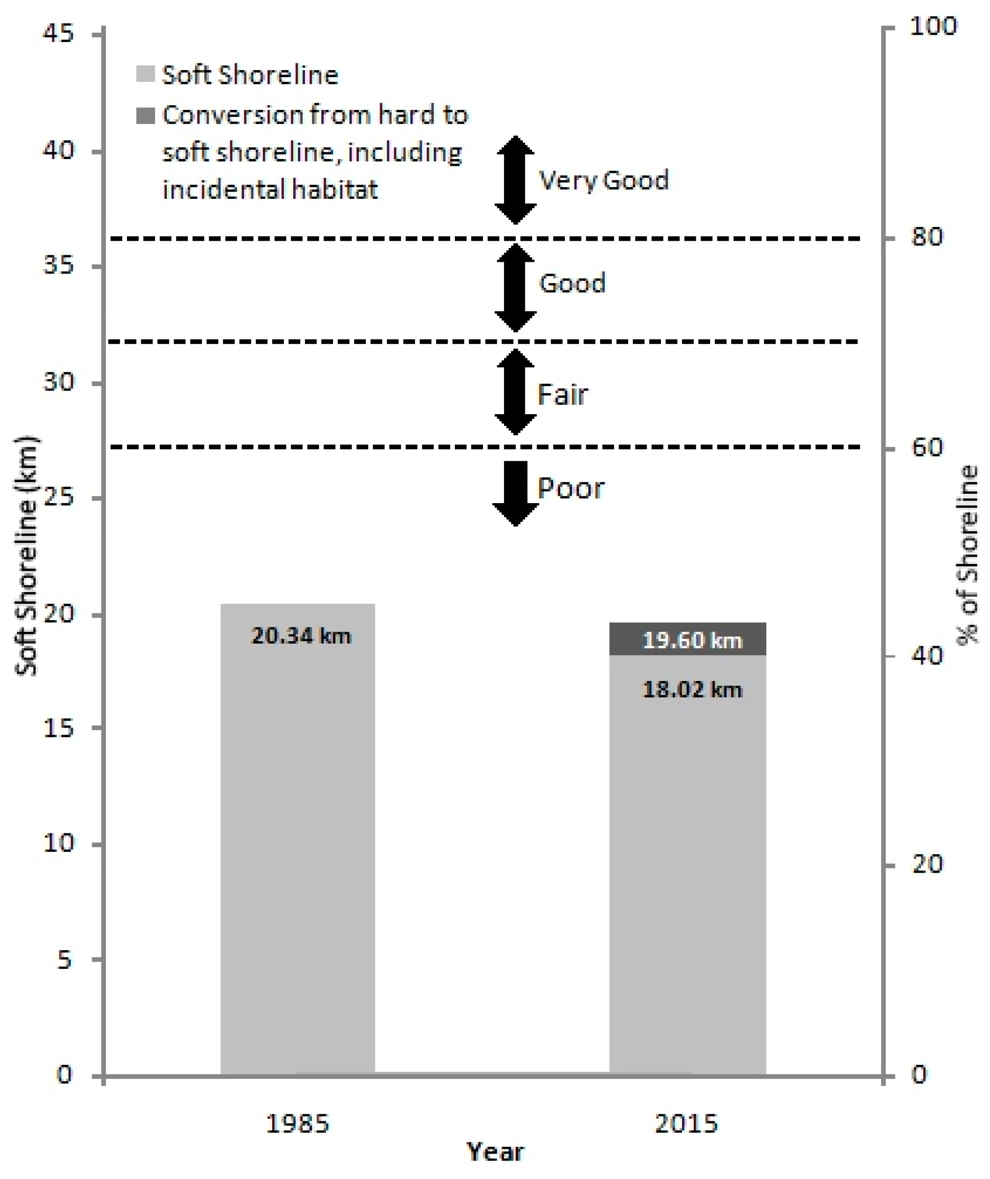
2.2. Soft Shoreline Survey Methods
- incidental habitat (i.e., adding habitat components to a structure like a breakwater), or
- changing from steel sheet piling or concrete breakwater to some limestone rip-rap that provided some limited habitat features.
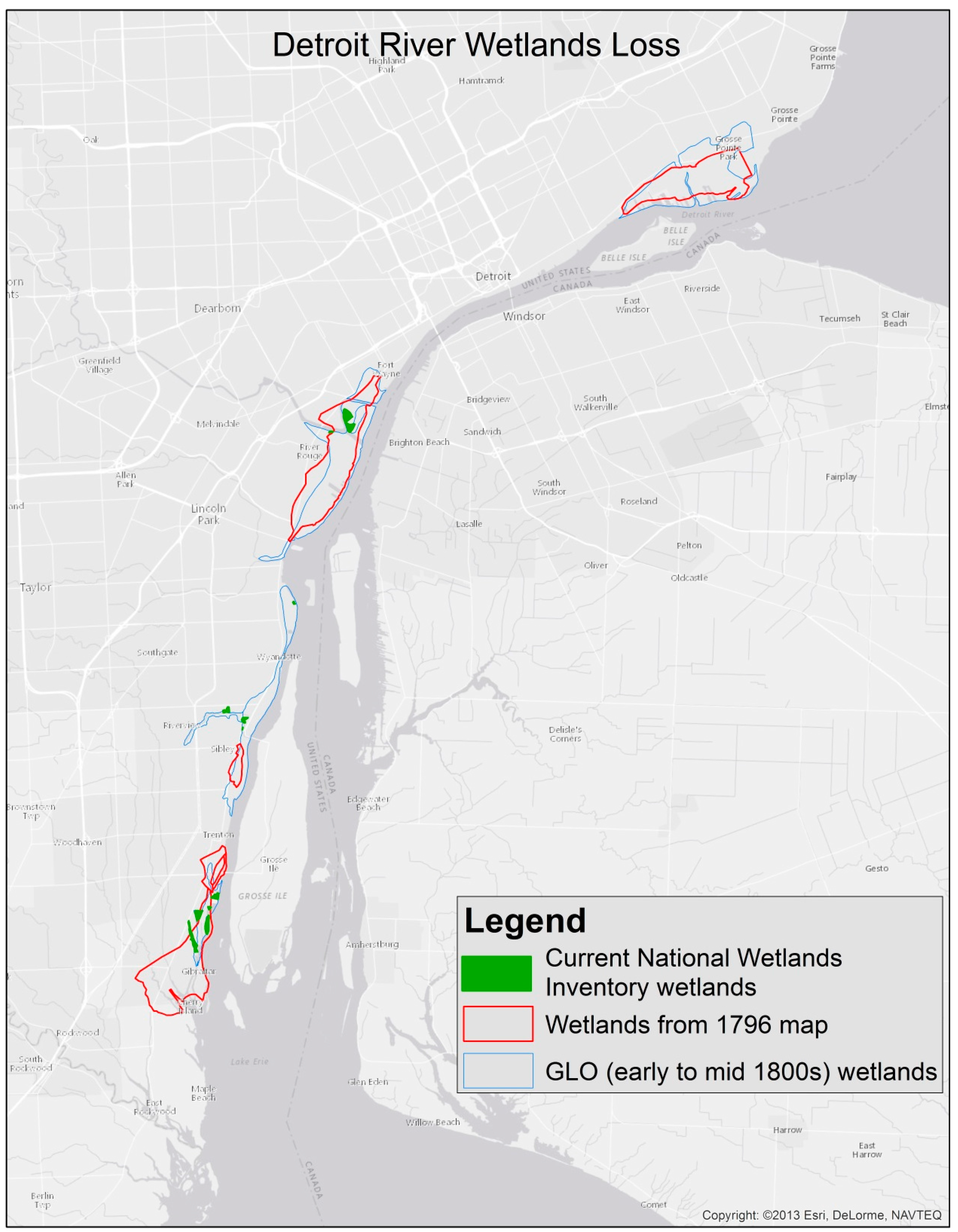
3. Historical Background
4. Results and Discussion
- less than 60% soft shoreline—poor quality;
- 60–70% soft shoreline—fair quality;
- 70–80% soft shoreline—good quality; and
- greater than 80% soft shoreline—very good quality.
5. Concluding Remarks and Outlook
- start with demonstration projects and attract many partners to leverage resources;
- treat habitat modification projects as experiments that promote learning, where hypotheses are developed and tested using scientific rigor;
- involve citizen scientists, volunteers, university students, and/or researchers in monitoring, and obtain commitments for post-project monitoring of effectiveness up front in project planning;
- measure benefits and communicate successes; and
- promote education and outreach, including public events that showcase results and communicate benefits [36].
Acknowledgments
Author Contributions
Conflicts of Interest
References
- Bolsenga, S.J.; Herdendorf, C.E. Lake Erie and Lake St. Clair Handbook; Wayne State University Press: Detroit, MI, USA, 1993. [Google Scholar]
- Hartig, J.H. Bringing Conservation to Cities: Lessons from Building the Detroit River International Wildlife Refuge; Aquatic Ecosystem Health and Management Society: Burlington, ON, Canada, 2014. [Google Scholar]
- Caulk, A.D.; Gannon, J.E.; Shaw, J.R.; Hartig, J.H. Best Management Practices for Soft Engineering of Shorelines; Greater Detroit American Heritage River Initiative: Detroit, MI, USA, 2000. [Google Scholar]
- Seitz, R.; Lipcius, R.; Olmstead, N.; Seebo, M.; Lambert, D. Influence of shallow-water habitats and shoreline development on abundance, biomass, and diversity of benthic prey and predators in Chesapeake Bay. Mar. Ecol. Prog. Ser. 2006, 326, 11–27. [Google Scholar] [CrossRef]
- Bilkovic, D.M.; Roggero, M.M. Effects of coastal development on nearshore estuarine nekton communities. Mar. Ecol. Prog. Ser. 2008, 358, 27–39. [Google Scholar] [CrossRef]
- Dugan, J.E.; Hubbard, D.M.; Rodil, I.F.; Revell, D.L.; Schroeter, S. Ecological effects of coastal armoring on sandy beaches. Mar. Ecol. 2008, 29, 160–170. [Google Scholar] [CrossRef]
- Lucrezi, S.; Schlacher, T.A.; Robinson, W. Can storms and shore armouring exert additive effectson sandy-beach habitats and biota. Mar. Freshw. Res. 2010, 61, 951–962. [Google Scholar] [CrossRef]
- Gittman, R.K.; Peterson, C.H.; Currin, C.A.; Joel Fodrie, F.; Piehler, M.F.; Bruno, John F. Living shorelines can enhance the nursery role of threatened estuarine habitats. Ecol. Appl. 2016, 26, 249–263. [Google Scholar] [CrossRef] [PubMed]
- Patrick, C.J.; Weller, D.E.; Ryder, M. The Relationship between Shoreline Armoring and Adjacent Submerged Aquatic Vegetation in Chesapeake Bay and Nearby Atlantic Coastal Bays. Estuaries Coasts 2016, 39, 158–170. [Google Scholar] [CrossRef]
- Schneider, J.; Heaton, D.; Leadlay, H. Extent of hardened shoreline. State of the Lakes Ecosystem Conference, U.S. Environmental Protection Agency, Chicago, Illinois and Environment Canada, Toronto, Ontario, Canada. 2009. Available online: https://binational.net//wp-content/uploads/2014/11/En161-3-1-2009E.pdf (accessed on 15 May 2017).
- Bourdo, E.A. A Review of the General Land Office Survey and of Its Use in Quantitative Studies of Former Forests. Ecology 1956, 37, 754–768. [Google Scholar] [CrossRef]
- King, F.B. Additional Cautions on the Use of the Glo Survey Records in Vegetational Reconstructions in the Midwest. Am. Antiq. 1978, 43, 99–103. [Google Scholar] [CrossRef]
- Hartig, J.H.; Kerr, J.K.; Breederland, M. Promoting soft engineering along Detroit River shorelines. Mag. Nat. Resour. Manag. Restor. 2001, 45, 24–27. [Google Scholar]
- Gabriel, A.O.; Bodensteiner, L.R. Impacts of Riprap on Wetland Shorelines, Upper Winnebago Pool Lakes, Wisconsin. Wetlands 2012, 32, 105–117. [Google Scholar] [CrossRef]
- Peterson, M.S.; Comyns, B.H.; Hendon, J.R.; Bond, P.J.; Duff, G.A. Habitat use by early life-history stages of fishes and crustaceans along a changing estuarine landscape: differences between natural and altered shoreline sites. Wetl. Ecol. Manag. 2000, 8, 209–219. [Google Scholar] [CrossRef]
- Romanuk, T.N.; Levings, C.D. Associations between Arthropods and the Supralittoral Ecotone: Dependence of Aquatic and Terrestrial Taxa on Riparian Vegetation. Environ. Entomol. 2003, 32, 1343–1353. [Google Scholar] [CrossRef]
- Wensink, S.M.; Tiegs, S.D. Shoreline hardening alters freshwater shoreline ecosystems. Freshw. Sci. 2016, 35, 764–777. [Google Scholar] [CrossRef]
- Jennings, M.J.; Bozek, M.A.; Hatzenbeler, G.R.; Emmons, E.E.; Staggs, M.D. Cumulative Effects of Incremental Shoreline Habitat Modification on Fish Assemblages in North Temperate Lakes. N. Am. J. Fish. Manag. 1999, 19, 18–27. [Google Scholar] [CrossRef]
- Pister, B. Urban marine ecology in southern California: The ability of riprap structures to serve as rocky intertidal habitat. Mar. Biol. 2009, 156, 861–873. [Google Scholar] [CrossRef]
- Roseman, E.F.; Kennedy, G.W.; Boase, J.; Manny, B.A.; Todd, T.N.; Stott, W. Evidence of Lake Whitefish Spawning in the Detroit River: Implications for Habitat and Population Recovery. J. Gt. Lakes Res. 2007, 33, 397–406. [Google Scholar] [CrossRef]
- Folz, D.J.; Meyers, L.S. Management of lake sturgeon, Ascipenser fluvescens, population in Lake Winnebago system, Wisconsin. In North American Sturgeons: Biology and Aquaculture Potential; Binkowski, F.P., Doroshov, S.I., Eds.; Springer: Dordrecht, The Netherlands, 1985; pp. 136–146. [Google Scholar]
- Binelli, M. Detroit City Is the Place to Be: An Afterlife of an American Metropolis; Henry Holt and Company: New York, NY, USA, 2012. [Google Scholar]
- Farmer, S. History of Detroit and Wayne County and Early Michigan: A Chronological Cyclopedia of the Past and Present; Silas Farmer and Company: Detroit, MI, USA, 1890. [Google Scholar]
- Levanen, A.J. The River’s Edge: A History of the Detroit Waterfront. Telescope 2000, XLVIII, 6–9. [Google Scholar]
- Dunnigan, B.L. Frontier Metropolis: Picturing Early Detroit, 1701–1838; Wayne State University Press: Detroit, MI, USA, 2001. [Google Scholar]
- Hudgins, B. Old Detroit: Drainage and Land Forms. Mich. Hist. Mag. 1946, 30, 348–368. [Google Scholar]
- Dunbar, W.F. Michigan: A History of the Wolverine State; W.B. Eerdmans Publishing Company: Grand Rapids, MI, USA, 1965. [Google Scholar]
- Hartig, J.H. Honoring Our Detroit River: Caring for Our Home; Cranbrook Institute of Science: Bloomfield Hills, MI, USA, 2003. [Google Scholar]
- Holli, M.G. (Ed.) Detroit; New Viewpoints, a Division of Franklin Watts: New York, NY, USA, 1976. [Google Scholar]
- Martelle, S. Detroit: A Biography; Chicago Review Press: Chicago, IL, USA, 2012. [Google Scholar]
- National Oceanic and Atmospheric Administration. Guidance for Considering the Use of Living Shoreline. 2015. Available online: http://www.habitat.noaa.gov/pdf/noaa_guidance_for_considering_the_use_of_living_shorelines_2015.pdf (accessed on 10 May 2017).
- Restore America’s Estuaries. Living Shorelines: From Barriers to Opportunities. 2015. Available online: https://www.estuaries.org/images/stories/RAEReports/RAE_LS_Barriers_report_final.pdf (accessed on 10 May 2017).
- Chesapeake Bay Foundation. Living Shorelines for the Chesapeake Bay Watershed; Chesapeake Bay Foundation: Annapolis, MD, USA, 2007. [Google Scholar]
- Essex Region Conservation Authority. Detroit River Canadian Shoreline Restoration Alternatives Selection Manual. 2014. Available online: http://erca.org/wp-content/uploads/2013/01/Detroit-River-Shoreline-Manual24Oct2014.pdf (accessed on 10 May 2017).
- Nguyen, N.; Tun, L.; Chan, L. If You Build It, They Will Come: Modifying Coastal Structures for Habitat Enhancement. 2016. Available online: http://www.thenatureofcities.com/2016/10/05/if-you-build-it-they-will-come-modifying-coastal-structures-for-habitat-enhancement/ (accessed on 14 November 2016).
- Hartig, J.H.; Zarull, M.A.; Cook, A. Soft shoreline engineering survey of ecological effectiveness. Ecol. Eng. 2011, 37, 1231–1238. [Google Scholar] [CrossRef]
- Pearsall, D.; de Grammont, P.C.; Cavalieri, C.; Chu, C.; Doran, P.; Elbing, L.; Ewert, D.; Hall, K.; Herbert, M.; Khoury, M.; et al. Returning to a Healthy Lake: Lake Erie Biodiversity Conservation Strategy. 2012. Available online: https://www.conservationgateway.org/ConservationByGeography/NorthAmerica/UnitedStates/michigan/Documents/LEBCS%20Report.pdf (accessed on 10 May 2017).
- Baird, R.C. Toward new paradigms in coastal resource management: Linkages and institutional effectiveness. Estuaries 1996, 19, 320–335. [Google Scholar] [CrossRef]
- Manny, B.A. Setting priorities for conserving and rehabilitating Detroit River habitats. In Honoring Our Detroit River: Caring for Our Home; Hartig, J.H., Ed.; Cranbrook Institute of Science: Bloomfield Hills, MI, USA, 2003; pp. 79–90. [Google Scholar]
- Canada Ontario Agreement Respecting Great Lakes Water Quality and Michigan Department of Natural Resources. Detroit River Remedial Action Plan: Stage 1; 1991. Available online: https://www.epa.gov/sites/production/files/2013-12/documents/1991_detroitriverrapstg1.pdf (accessed on 10 May 2017).
- Detroit River Public Advisory Committee. Targets for Removal of “Loss of Fish and Wildlife Habitat” and “Degradation of Fish and Wildlife Populations” Beneficial Use Impairments of the Detroit River Area of Concern; Michigan Department of Environmental Quality: Taylor, MI, USA, 2014. [Google Scholar]
- Legge, S. A plea for inserting evidence-based management into conservation practice. Anim. Conserv. 2015, 18, 113–116. [Google Scholar] [CrossRef]
- Essex Region Conservation Authority. Detroit River Shoreline Assessment Report; ERCA: Essex, ON, Canada, 2012. [Google Scholar]
- Bence, S. Army Corps Collaborates with UWM to Create Breakwater Habitat in Milwaukee. 2016. Available online: http://wuwm.com/post/army-corps-collaborates-uwm-create-breakwater-habitat-milwaukee#stream/0 (accessed on 3 April 2017).


| Natural Resource Attribute | Description |
|---|---|
| Birds |
|
| Fish |
|
| Biodiversity and International Designations |
|
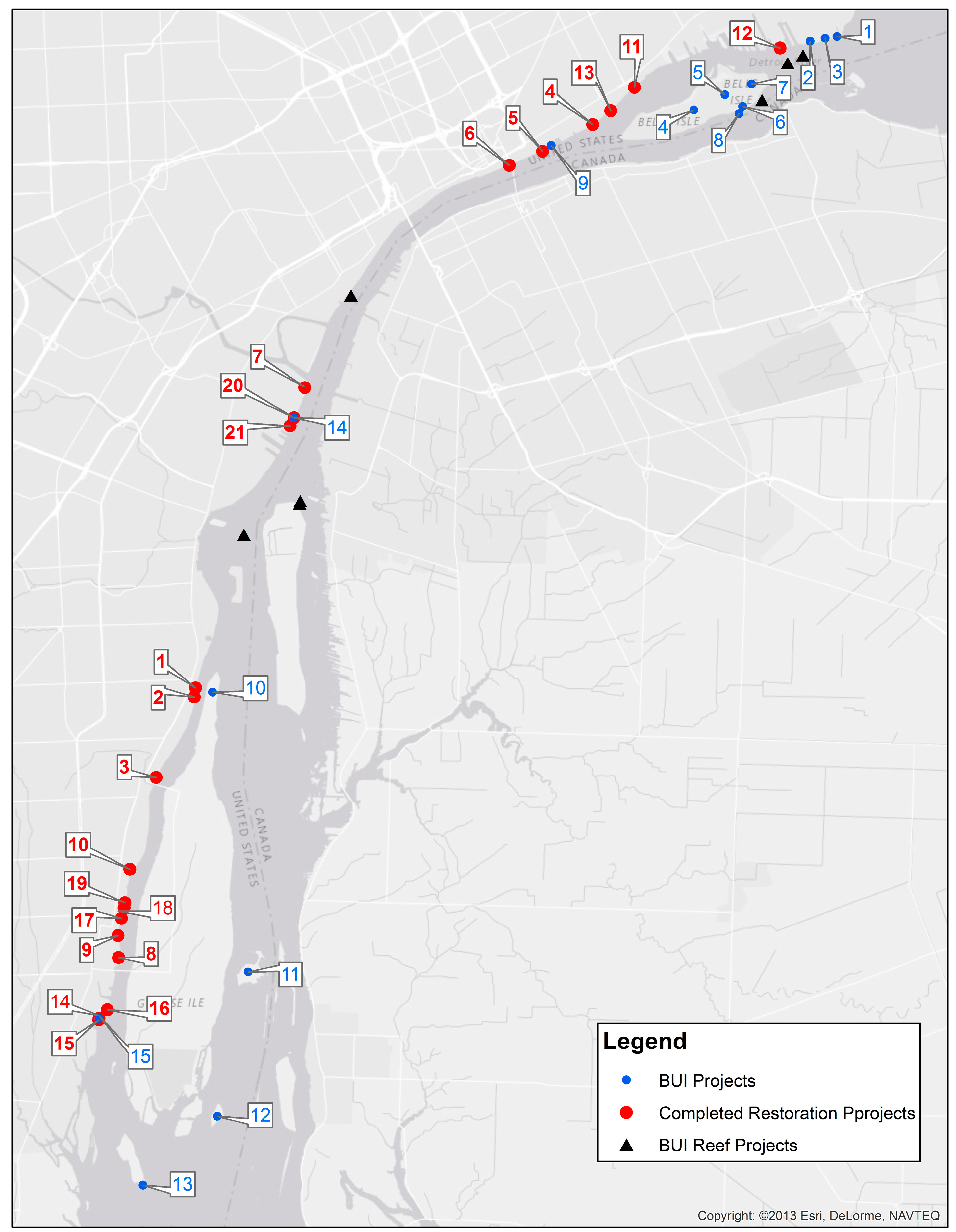
| Location | Figure 3 Locator | Project Type | Project Goals | Project Description and Cost | Timeframe | Partners | Monitoring |
|---|---|---|---|---|---|---|---|
| BASF Waterfront Park, Wyandotte, Michigan | 1 ● | Rip-rap | Transform a former shipbuilding and chemical manufacturing site (40 ha) along the Detroit River into a public recreation area (called BASF Waterfront Park) and a nine-hole golf course | As part of a $9.1 million park redevelopment and brownfield cleanup, 390 m of shoreline were stabilized and enhanced using limestone rip-rap | Consent Decree signed in 1985; golf course and park opened in 1995 | City of Wyandotte, BASF Corp., Michigan Department of Environmental Quality | None |
| BASF Park, Wyandotte, Michigan | 2 ● | Small rip-rap | Demonstrate use of Elastocoast (Elastomeric revetment that stabilizes shorelines and enhances habitat by increasing interstitial spaces) along the Detroit River shoreline of BASF Park | Stabilized nine meters of Detroit River shoreline to a depth of 37 cm with five-cm crushed limestone bound together with the Elastocoast product; $6000 | 2008 | BASF Corporation, City of Wyandotte | Qualitative |
| BASF Riverview, Trenton Channel, Riverview, Michigan | 3 ● | Incidental habitat | Remediate a contaminated site, add incidental habitat to steel sheet piling walls, and create one acre of fish spawning habitat | Following remediation of a brownfield site, incidental habitat was added to 366 m of steel sheet piling, and 0.4-ha of walleye, smallmouth and largemouth bass, and sturgeon spawning habitat was created; $100,000 | 2007–2008 | BASF Corporation, Michigan Department of Environmental Quality | None |
| Detroit RiverWalk-Stroh River Place, Detroit, Michigan | 4 ● | Incidental habitat | Build a section of the Detroit RiverWalk in front of Stroh River Place and enhance riparian habitat | Built a 305-m section of the Detroit RiverWalk using a cantilever design with habitat features beneath the cantilevered RiverWalk; $1 million | 2006–2007 | Detroit Riverfront Conservancy, Stroh Companies, Inc., Omni Hotel, and Tallon Industries | None |
| Detroit RiverWalk-West of Milliken State Park, Detroit, Michigan | 5 ● | Rip-rap | Stabilize the shoreline along the Detroit RiverWalk and enhance aquatic habitat | Stabilized 152 m of shoreline with varying sizes of rock armor stone and enhanced aquatic habitat; $100,000 | 2003–2004 | Detroit Riverfront Conservancy and General Motors Corporation | None |
| Detroit-Wayne County Port Authority, Detroit, Michigan | 6 ● | Incidental habitat | Enhance fish spawning habitat in conjunction with construction of a 61-m wharf to support Port Authority operations | Enhanced fish spawning habitat through placement of 512 m3 of limestone rip-rap covering 832 m2 (64 m by 13 m) at the base of the wharf | 2007 | Detroit/Wayne County Port Authority, Detroit Riverfront Conservancy | None |
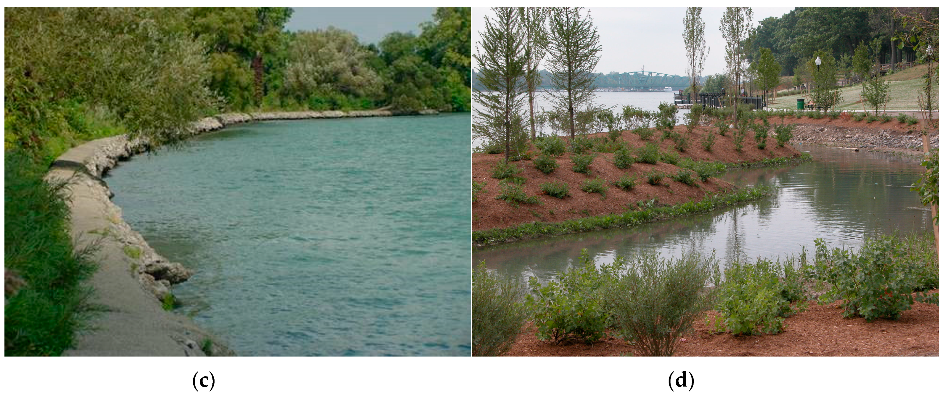
| DTE’s Rouge Power Plant, River Rouge, Michigan | 7 ● | Soft shoreline | Remove broken concrete and asphalt, stabilize shoreline, and enhance habitat | Reconstructed 61 m of natural shoreline using soft engineering techniques and reestablished a natural riparian buffer made up of four Michigan native plant communities; $30,000 | 2005 | DTE Energy, Nativescape, U.S. Fish and Wildlife Service, Department of Environmental Quality, and six other partners | Qualitative |
| Elizabeth Park—Phase 2, South River Walk, Trenton, Michigan | 8 ● | Soft shoreline | Stabilize and enhance 183 m of shoreline, recreate river walk, and enhance underwater fish habitat | Removed a 1910 concrete breakwall from the north end of Elizabeth Park, stabilized the shoreline using soft engineering techniques, and created two oxbow islands for nursery habitat for fish; $925,000 | 2005 | Clean Michigan Initiative and Wayne County Parks | Quantitative |
| Elizabeth Park—Phase 3, North River Walk, Trenton, Michigan | 9 ● | Rip-rap | Stabilize 250 m of Detroit River shoreline, complete the River Walk, and enhance riparian habitat | Graded back the shoreline and stabilized it with Armor stone and landscape plantings, and completed River Walk; $400,000 | 2012 | Michigan Natural Resources Trust Fund and Wayne County Parks | None |
| Ellias Cove, Trenton, Michigan | 10 ● | Soft shoreline | Remediate mercury, lead, zinc, and PCB contaminated sediment from Ellias Cove and restore the shoreline using soft engineering techniques | Removed 88,000 m3 of sediment and disposed contaminated sediment in special contaminant cell at Pointe Mouillee Confined Disposal Facility in western Lake Erie and restored 270 m of shoreline habitat, including nursery habitat for fish; $150,000 for habitat portion | 2006 | U.S. Environmental Protection Agency, Michigan Department of Environmental Quality, Great Lakes Basin Program for Soil Erosion and Sediment Control, and seven other partners | Qualitative |
| Gabriel Richard Park, Detroit, Michigan | 11 ● | Rip-rap | Stabilize river shoreline, restore fish habitat, and provide aesthetically-pleasing environment | Stabilized and restored 300 m of shoreline with fish habitat components, including the addition of two fishing overlooks; $300,000 | 2006–2007 | Detroit Riverfront Conservancy, Detroit Parks and Recreation, and JJR | None |
| Maheras Gentry Park, Detroit, Michigan | 12 ● | Soft shoreline | Create an oxbow and restore fish and wetland habitat as mitigation for the construction of Conner Creek Combined Sewer Overflow Control Facility | Removed 38,300 m3 of soil to create an oxbow, restored 508 m of shoreline habitat, planted native aquatic plants to improve fish habitat, and created fish spawning and nursery areas; $2.3 million | 2000–2004 | Detroit Water and Sewerage Department and Detroit Parks and Recreation | Qualitative |
| Mt. Elliott Park, Detroit, Michigan | 13 ● | Rip-rap | Restore shoreline using limestone of varying sizes and native plant materials in an effort to help restore fish and wildlife habitat | Restored 200 m of shoreline, including providing an interactive water feature and playscape for children that will teach the importance of water; $200,000 for shoreline habitat work | 2012–2013 | Detroit Riverfront Conservancy and Detroit Recreation Department | None |
| Refuge Gateway Shoreline along the Trenton Channel of the Detroit River, Trenton, Michigan | 14 ● | Soft shoreline | Stabilize shoreline using soft engineering techniques and restore coastal wetland and upland buffer habitats | Stabilized 365 m of shoreline using soft shoreline engineering techniques and restored 4.2 ha of emergent marsh, 1.7 ha of submergent marsh, and 4.8 ha of upland buffer habitats; $746,000 | 2010 | Wayne County, Michigan Department of Natural Resources, U.S. Fish and Wildlife Service, and six other partners | Qualitative |
| Refuge Gateway, School Ship Dock and Fishing Pier, Trenton, Michigan | 15 ● | Incidental habitat | Enhance fish spawning habitat in conjunction with construction of a 61-m fishing pier | Nearly 418 m2 of 15–25 cm diameter limestone was placed along a 69 m long × 4.6 m wide fishing pier at a depth of 3–4.6 m to provide spawning habitat and refuge for fish and other aquatic species. Benefiting will be speleophilic (cave spawners) and lithophilic (rock spawners) fish species such as the northern madtom (endangered in State of Michigan and Province of Ontario), lake sturgeon, rock bass, smallmouth bass, and walleye. $100,000 | 2015–2016 | Wayne County, U.S. Fish and Wildlife Service, Great Lakes Fishery Trust, Michigan Natural Resources Trust Fund, CN Rail, DTE Energy, and others | None |
| Solutia Plant (now called Eastman Chemical), Trenton, Michigan | 16 ● | Rip-rap | Stabilize shoreline and enhance habitat | Stabilized 300 m of dike walls on two existing ponds located on the Detroit River using a variety of limestone rip-rap to enhance shoreline habitat (in lieu of concrete breakwalls or steel sheet piling); $150,000 | 2000 | Solutia Chemical Company | None |
| Street-End Parks, Trenton, Michigan | 17, 18, 19 ● | Rip-rap and underwater fish habitat | Construct three street-end parks and enhance fish habitat to improve fishing opportunities | Created three pocket parks, stabilized 25 m of shoreline at each park (total of 75 m), and rehabilitated habitat in the Detroit River; $816,000 | 2001–2002 | City of Trenton, Clean Michigan Initiative, Michigan Natural Resources Trust Fund, and Michigan Coastal Zone Management Program | None |
| U.S. Steel Shoreline near 203-cm Rolling Mill, River Rouge, Michigan | 20 ● | Rip-rap | Restore riparian shoreline habitat using soft shoreline engineering techniques and enhance adjacent upland habitats | Restored 335 m of riparian shoreline habitat (bank stabilization was achieved with large limestone boulders and over 200 live stakes; sand ramps were also created to allow turtles to exit the river and lay their eggs) and 1.9 ha of upland habitat (native wildflowers, shrubs, and trees, and several large snake hibernacula) adjacent to the shoreline; $670,000 | 2010–2013 | Detroit River Remedial Action Plan, Friends of the Detroit River, U.S. Steel, and others | Qualitative |
| U. S. Steel Shoreline West of Belanger Park, River Rouge, Michigan | 21 ● | Soft shoreline | Restore shoreline using soft shoreline engineering techniques and enhance fish and wildlife habitat | Restored 610 m of Detroit River shoreline; created wetlands that provide spawning and fingerling habitat, and created an upland buffer area to provide water quality protection; $211,000 | 2004–2005 | U.S. Steel, Nativescape, and U.S. Fish and Wildlife Service | Qualitative |
| Delisting Project | Figure 3 Locator | Brief Description | Status |
|---|---|---|---|
| Detroit River Reefs | ▲ | Construct fish spawning reefs for native fishes at six locations | Two fish spawning reefs off Belle Isle, two off Fighting Island, and one off Grassy Island constructed in 2004–2016, totaling 4.05 ha; one additional 0.93-ha reef to be constructed in 2017 |
| Detroit Upper Riverfront Parks Restoration | 1, 2, 3 ● | Restore shoreline habitat at Mariner Park, Lakewood East Park, and A.B. Ford Park | In design phase |
| Belle Isle Hydrologic Analysis, Feasibility and Pre-Design | 4 ● | Investigate the waterways of Belle Isle in order to effectively design the habitat restoration projects in the Belle Isle forested wetland and Lake Okonoka | Underway |
| Belle Isle Forested Wetland Restoration | 5 ● | Restore approximately 81 ha of wet-mesic flatwoods complex and adjacent habitat | Underway |
| Lake Okonoka Restoration with River Connection and Shoreline Restoration | 6 ● | Enhance habitat for birds, fish, amphibians, and reptiles | Underway |
| Milliken State Park Pocket Marsh with River Connection | 9 ● | Create a naturalized area of nearshore, protected, shallow water habitat and shoreline with direct connection to the Detroit River | In design phase |
| Hennepin Marsh Restoration | 10 ● | Protect and enhance the existing submergent wetlands and create additional emergent wetland | Not started |
| Stony Island Shoal Reconstruction | 11 ● | Restore 610 m of shoals to protect the island from further degradation of existing wetlands, and provide an environment for the natural regeneration of additional wetland habitat over time | Started in 2016 and to be completed in 2017 |
| Sugar Island Restoration | 12 ● | Stabilize the island and restore fish and wildlife habitats | Not started |
| Celeron Island Restoration and Shoal Construction | 13 ● | Prevent further degradation to the southern end of the island by constructing shoal system and concurrently enhance fish and wildlife habitat | In design phase |
| Blue Heron Lagoon Restoration | 7 ● | Reconnect and naturalize the connection between Blue Heron Lagoon and the Detroit River, restoring fish access to over 16 ha of existing wetlands, shallow and deep-water habitat and over 3.5 km of canal habitat, including coastal wetlands specifically designed for fish rearing and nursery habitat | Completed in 2013 |
| Belle Isle South Fishing Pier Restoration | 8 ● | Increase fish populations by providing connectivity between fish spawning and nursery areas in the river by creating 1 ha of wetlands immediately downstream of an existing spawning reef and creating deep and shallow water habitats in the flat bottomland of the pier | Completed in 2013 |
| U. S. Steel Shoreline Restoration | 14 ● | Restored 335 m of riparian shoreline habitat and 1.9 ha of upland habitat adjacent to the shoreline | Completed in 2013 |
| Shoreline Restoration at Wayne County’s Refuge Gateway | 15 ● | Stabilized 365 m of shoreline using soft shoreline engineering techniques and restored 4.2 ha of emergent marsh, 1.7 ha of submergent marsh, and 4.8 ha of upland buffer habitats | Completed in 2010 |
© 2017 by the authors. Licensee MDPI, Basel, Switzerland. This article is an open access article distributed under the terms and conditions of the Creative Commons Attribution (CC BY) license (http://creativecommons.org/licenses/by/4.0/).
Share and Cite
Hartig, J.H.; Bennion, D. Historical Loss and Current Rehabilitation of Shoreline Habitat along an Urban-Industrial River—Detroit River, Michigan, USA. Sustainability 2017, 9, 828. https://doi.org/10.3390/su9050828
Hartig JH, Bennion D. Historical Loss and Current Rehabilitation of Shoreline Habitat along an Urban-Industrial River—Detroit River, Michigan, USA. Sustainability. 2017; 9(5):828. https://doi.org/10.3390/su9050828
Chicago/Turabian StyleHartig, John H., and David Bennion. 2017. "Historical Loss and Current Rehabilitation of Shoreline Habitat along an Urban-Industrial River—Detroit River, Michigan, USA" Sustainability 9, no. 5: 828. https://doi.org/10.3390/su9050828
APA StyleHartig, J. H., & Bennion, D. (2017). Historical Loss and Current Rehabilitation of Shoreline Habitat along an Urban-Industrial River—Detroit River, Michigan, USA. Sustainability, 9(5), 828. https://doi.org/10.3390/su9050828