Article

Accessibility of Water-Related Cultural Ecosystem Services through Public Transport—A Model for Planning Support in the Stockholm Region

1
Department of Physical Geography, Stockholm University, SE-10691 Stockholm, Sweden
2
Department of Sustainable Development, Environmental Science and Engineering, KTH Royal Institute of Technology, SE-10044 Stockholm, Sweden
*
Author to whom correspondence should be addressed.
Sustainability 2017, 9(3), 346; https://doi.org/10.3390/su9030346
Submission received: 22 December 2016 / Revised: 1 February 2017 / Accepted: 16 February 2017 / Published: 26 February 2017
(This article belongs to the Special Issue Urban Sustainability and Planning Support Systems)

Abstract

:
Planning for sustainable cities involves supporting compact, energy-efficient urban form as well as maintaining attractive and liveable urban landscapes. Attractive cities depend highly on services provided by ecosystems, especially cultural ecosystem services (ES), which give direct benefits to urban citizens. Therefore, access to a diversity of urban functions and publicly available ES by walking and public transport should be considered when planning for sustainable cities. This could be facilitated by user-friendly planning support models. The aim of this study was to develop a GIS-based model for assessing accessibility to ES, more specifically, water-related cultural ecosystem services (WCES), via walking and public transport, with input from stakeholders. The model was applied to the Stockholm region in Sweden. Travel times and census data were used to derive measures and maps of accessibility to prioritised WCES in the region, today and in urbanisation scenarios for 2050. The results showed how access to WCES varied spatially within the region. The number of potential visitors to different WCES sites now and in the future urbanisation scenarios was estimated, and areas in need for future development of the public transport system as well as WCES were identified. The GIS-based accessibility model has potential to be used as planning support in urban planning.

1. Introduction

Planning for sustainable cities involves supporting compact, energy-efficient urban form while providing attractive and liveable urban landscapes. Addressing this nexus in urban planning is increasingly urgent since more than half of the world’s population is currently living in urban areas and this proportion is predicted to keep increasing [1,2,3]. Attractive cities depend to a large extent on services provided by ecosystems, not at least cultural ES, which are essential for aesthetics, recreation values and liveability of urban landscapes, and give direct benefits to urban citizens [4,5,6]. There are also strong linkages between the general public health of urban residents, physical activity, psychological well-being, and accessibility to green spaces (e.g., [7,8,9]). Many studies of cultural ES have discussed different development strategies and related trade-offs and conflicts, and there is a general consensus that cultural ES should be integrated into planning [10].
While energy and transport efficiency require compact urban form, access to diverse urban functions through walking and public transport is equally important to minimise transport needs [11,12]. A major challenge for planning a sustainable urban development is therefore to simultaneously promote compact, intensely used cities with a minimum of transport, as well as attractive and liveable cities that preserve valuable green and blue space [11,12,13,14,15].
Furthermore, in planning, it is essential to include the spatial characteristics of ES, in order to account for the spatial relation between ES-providing areas and the location of the beneficiaries [16,17,18,19,20]. This is especially important for cultural ES such as recreation that requires users to move to the ES-providing area, in contrast to some ES that can be brought to the beneficiaries [21]. The geographical accessibility of ES can be assessed by analysing travel times between beneficiaries and the ES-providing areas via the transport networks [17,19,20,22]. This can be done with the help of least-cost path analysis in geographical information systems (GIS), which is a functionality that allows the best way between two locations to be identified [18,23].
Mörtberg et al. [22] used GIS to analyse the combined accessibility to jobs and to ES for urban residents in alternative urbanisation scenarios in the Stockholm region. However, as pointed out by these authors, their study did not include public transport which is an important part of the planning support for a sustainable urban development. Public transport is multimodal and need to take into account walking, waiting and use of vehicles with different time schedules. Most previous attempts to use multimodal network analysis to assess accessibility have not accounted for temporal variations in travel times, simply because standard GIS software does not yet support this, although there is potential for it. Instead, average times have been used for transfer time, waiting time and the time spent in vehicles [24].
However, a fairly new data format, general transit feed specification (GTFS), provides new opportunities for handling the temporal dimension of public transport. Online journey planners are typically based on GTFS data. Salonen et al. [25] used the application programming interface (API) of a local journey planner to calculate travel times, hence creating a model accounting for temporal variation. Using the journey planner, they adopted a door-to-door approach and included all aspects of the journey such as waiting times. This was done completely outside GIS. In a slightly different approach, Djurhuus et al. [24] used public transport schedules in a structured query language (SQL) database to calculate travel times and keep track of available departures for different stops, while they used GIS to calculate walking times along a street network.
For planning support, it may however be advantageous to develop tools within GIS in order to facilitate use in the planning process. Executing all functionalities in GIS rather than interchanging between different tools or needing programming skills as in the previously developed models, can make planning support tools more applicable and easy to use. Another approach to integrating transportation models with assessment of urban development scenarios and land use issues, are integrated modelling platforms [26,27,28,29]. Models for access to ES through the multimodal public transport are or can to different extent be integrated in such platforms. In either approach, for integration of emerging sustainability aspects in planning, it is essential that the planning support model can be operated by planners and address urgent issues such as access to ES. Otherwise models may not be effectively integrated into the planning process [30,31,32,33]. Thus, relevant planning support is required when planning for liveable, sustainable cities where ES are preserved and accessible through walking and public transport, in midst of rapid urbanisation and city compaction.
The overall aim of this study was to develop a GIS-based model for assessing accessibility of ES via walking and public transport that could be used as planning support and be easily integrated into the urban planning process. The model was applied to the Stockholm region, including the City of Stockholm, the capital of Sweden. This region can be characterised by green and blue structures that contributes to its attractiveness, an on-going strong population increase, and a policy for compaction of several urban and suburban areas. The specific objectives were to derive knowledge on prioritised ES through stakeholder engagement; and to analyse the accessibility to prioritised ES, specifically WCES, by creating a network model that permitted the calculation of the shortest travel times between defined origins and WCES. From the travel times measures of accessibility could be derived, of WCES in the Stockholm region, today and in urbanisation scenarios for 2050.

2. Materials and Methods
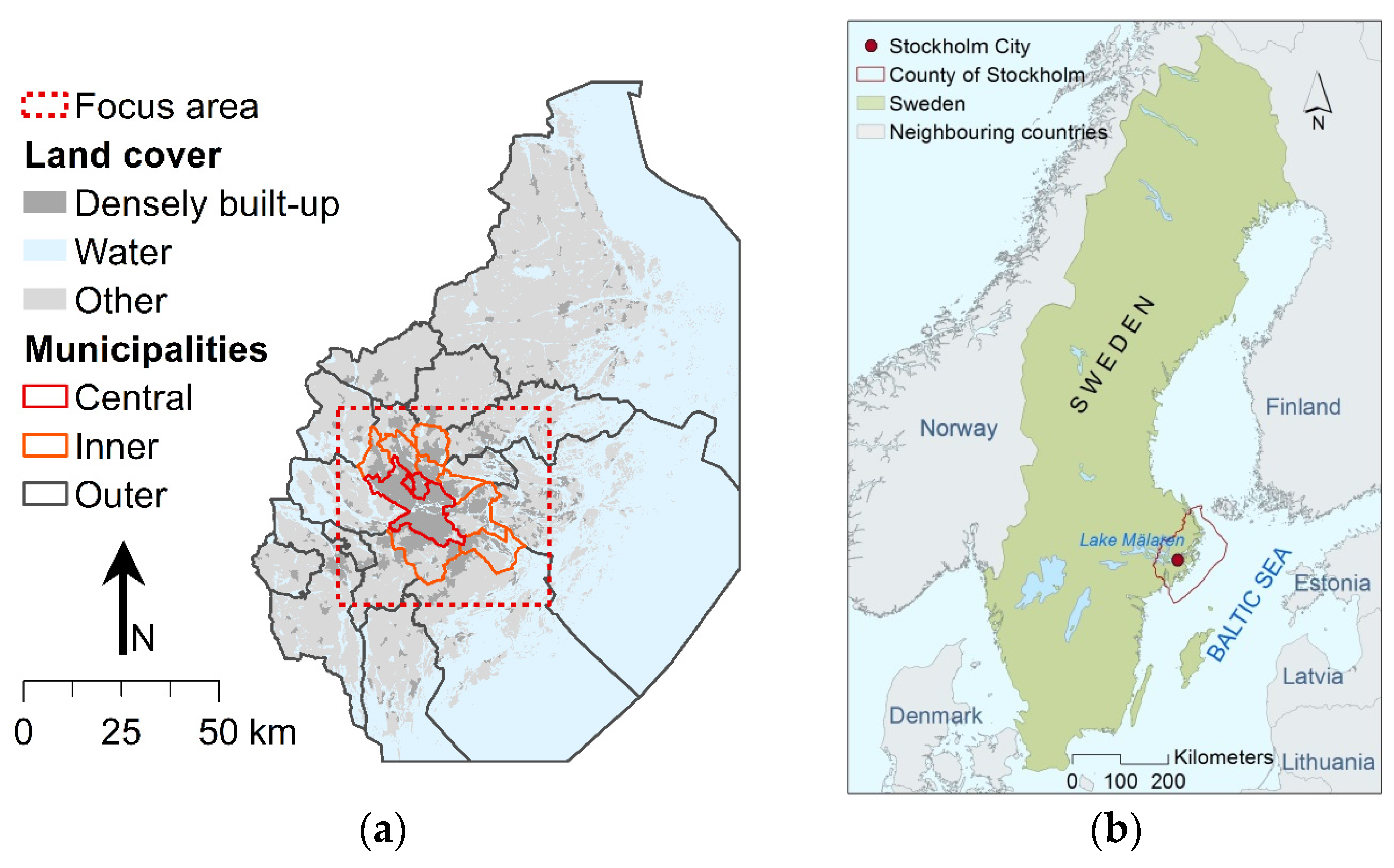
2.1. Study Area

The study area embraced the County of Stockholm including the City of Stockholm, the capital of Sweden, and its surroundings (Figure 1). It covers an area of 6519 km2, consists of 26 municipalities and had a population of around 2.2 million people in 2014. The mean population density was 337 inhabitants/km2 for the County of Stockholm and 3660 inhabitants/km2 for the City of Stockholm by 2015 [34], which illustrate the great variations in population density between the inner city, suburban and peri-urban areas. An important attribute of the region that makes it attractive to residents is its proximity to water and green areas, and it is seen as important to preserve these characteristics for the future (Growth and Regional Planning Administration, GRPA [35]).
The population in the region is growing rapidly and is expected to reach around 3 million by 2050 [34], leading to an urgent need for new housing. As part of the work on the most recent regional development plan, alternative urbanisation scenarios for the year 2050 were developed and analysed ([37] and Office of Regional Planning, ORP [38]). These scenarios included predictions of the population growth with different assumptions regarding net immigration. In the current study, a baseline scenario and a high net immigration scenario were used when making predictions for WCES accessibility by 2050.
The central and inner municipalities of the County of Stockholm were the focus of this study (see Figure 1). Within this area, the population density is already high and planning for a compact urbanisation pattern, with low transportation needs and a high share of walking and public transport, is largely targeted. In 2016, GRPA started working on the next regional development plan, to be used from its implementation until the year 2050 [35]. In this plan, urban sustainability plays an important role, for example requiring the concept of ES to be applied when formulating objectives, discussing demands in the region and suggesting measures for a sustainable development. It also gives water a more prominent role than in the previous regional development plan [35,39].

2.2. Focus Group Workshop

In order to ensure that the method development was highly relevant and useful for supporting urban planning in the study area, a focus group workshop was arranged. In the workshop, eight regional planners from GRPA participated, contributing with knowledge on planning and development of the region. In addition, two representatives from the Swedish Society for Nature Conservation (SSNC) participated, adding a strong environmental perspective. Including this group of stakeholders allowed for gaining an understanding of different perspectives on important WCES in the Stockholm region. The workshop encouraged different stakeholders to discuss and constructively explore their differences and arrive at carefully considered conclusions. The specific objectives of the workshop were to identify prioritised WCES for the County of Stockholm on a regional level that are important to consider when planning for the future, and to specify outputs that might be interesting to derive from the GIS-based accessibility model. A more detailed documentation of the content and discussions at the workshop can be found in the supplementary materials.

2.3. Data

Three types of data are required for a least-cost path analysis of a network: origins, destinations and a transport network with known travel costs, e.g., travel time, along the network. An origin represents the starting point of a trip, a destination is the end point of the trip and transport between the points occurs via the transport network. Two types of origins were used in the current analysis. The main type was centroids of census units, so called base areas, which were assumed to represent all the inhabitants within the base area. These base areas are the units for census data and therefore used in the mentioned predictions of future population changes [36]. For each base area, the population in 2015 and the predicted population in the baseline and high net immigration scenarios for 2050 according to forecasts [37] were available. The analysis was also performed with elementary schools in the county as origins, as a way of assessing accessibility for children [40]. The transport network used consisted of the public transport operated by Storstockholms Lokaltrafik (SL), the public transport provider in County of Stockholm [41]. In addition, to allow pedestrians to walk between stops, a national street network dataset containing streets for cars, cycles and pedestrians was used (Swedish Transport Administration, STA [42]).
Based on the focus group discussions, public bathing sites and departure points for public boats to the archipelago were used as destinations in the analysis. The Swedish Agency for Marine and Water Management (SAMWM [43]) provides data on water quality for bathing sites all over Sweden, including data on location. Municipalities are obliged by law to report the water quality of registered EU bathing sites (bathing sites with an average of more than 200 visitors per day during the bathing season). Municipalities can also choose to monitor other bathing sites and report those to SAMWM. As not all municipalities have all their public bathing sites registered in the SAMWM database, complementary data on bathing sites were requested from the 26 municipalities in the County of Stockholm. Of these, 16 municipalities delivered the requested data. The locations of public archipelago boat stops operated by Waxholmsbolaget were obtained from SL [41]. For visualisation, the GSD overview map [44] was used. An overview of data used in the study is shown in Table 1.

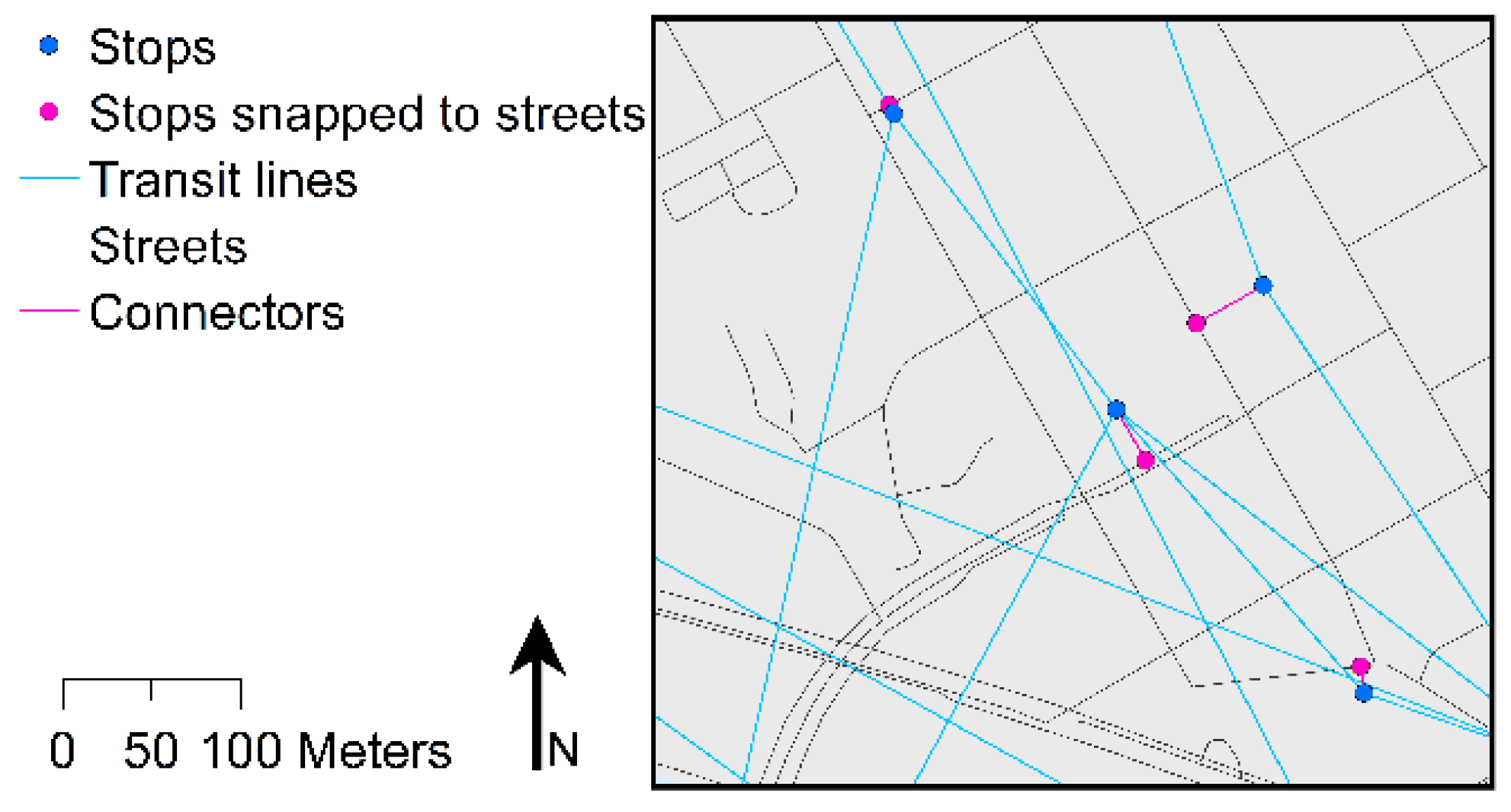
2.4. Creation of a Network Model

The accessibility analysis was performed using the GIS software ArcGIS 10.3 [45]. For the least-cost path analysis, an extension in ArcMap called “Network Analyst” was used. To make it possible to use the GTFS public transport data with the Network Analyst, a prototype toolbox called “Add GTFS to a Network Dataset” was used [46]. This toolbox made it possible to create GIS features of public transport transit lines and stops, as well as creating connectors between public transport stops and a street network, so that walking between the stops can be modelled. It also made it possible to use the generated features in a network model using the time-table data from the GTFS files to calculate travel time.
The public transport GTFS data were transformed into GIS format, i.e., transit lines and stop points, using the “Add GTFS to a Network Dataset” tool. Each public transport stop within 100 m from the street network was snapped to the street by creating a corresponding point on the closest street and connecting the two points with a line. This made it possible to model people walking between public transport stops, e.g., when going from a metro station to a bus stop. A point layer containing the centroid of each base area polygon was created to be used as origins in the network analysis.
Transit lines, stops for public transport, street lines, stops snapped to streets and connectors between streets and public transport stops were used to create a network model. This comprised a dataset where edges (network lines) were linked to each other due to connections at defined junctions and where the cost, in this case travel time, for each edge segment was stored as an attribute. A part of this network with the different types of edges and junctions can be seen in Figure 2.
Three connectivity groups were used for the network, defining rules for movement between different parts of the network. It was assumed that two edges were only connected if they were in the same connectivity group or if they had a common junction that was part of both connectivity groups. Table 2 shows the connectivity groups that were applied. As the table illustrates, these groups made it possible to go from a transit line to a street via a connector, but not for instance to get on or off a bus between two stops.
An attribute storing travel time for each edge segment was created. For the transit line edges, travel was allowed in the forward direction only and the travel times were calculated using the timetable information from the GTFS data with the mentioned tool. For the connectors the travel time was set to 0, as these do not correspond to any real transport. However, a travel time could have been added to model the time it takes to board or get off a vehicle. For street edges, travel time was calculated as
t s t r e e t [ m i n ] = l e n g t h   [ m ] w a l k s p e e d   [ m m i n ]
and the default value for the parameter “walkspeed” was set to 70 m/min. The main assumptions made when constructing the model were:
  • Public transport network includes transits operated by SL in April 2016.
  • People can access the network via streets and public transport stops.
  • Public transport transit lines can only be accessed via stops.
  • Origins (e.g., base areas centroids) and destinations (e.g., bathing sites) are reachable via the network if they are located within 500 m of a street or a public transport stop.
  • The travel time to a specific destination is uniform within a base area.
  • It is possible to walk between public transport stops via the street network.
  • The walk speed along the street network is 70 m/min.
  • Travel times along public transport transits correspond to time tables.

2.5. Accessibility Calculations
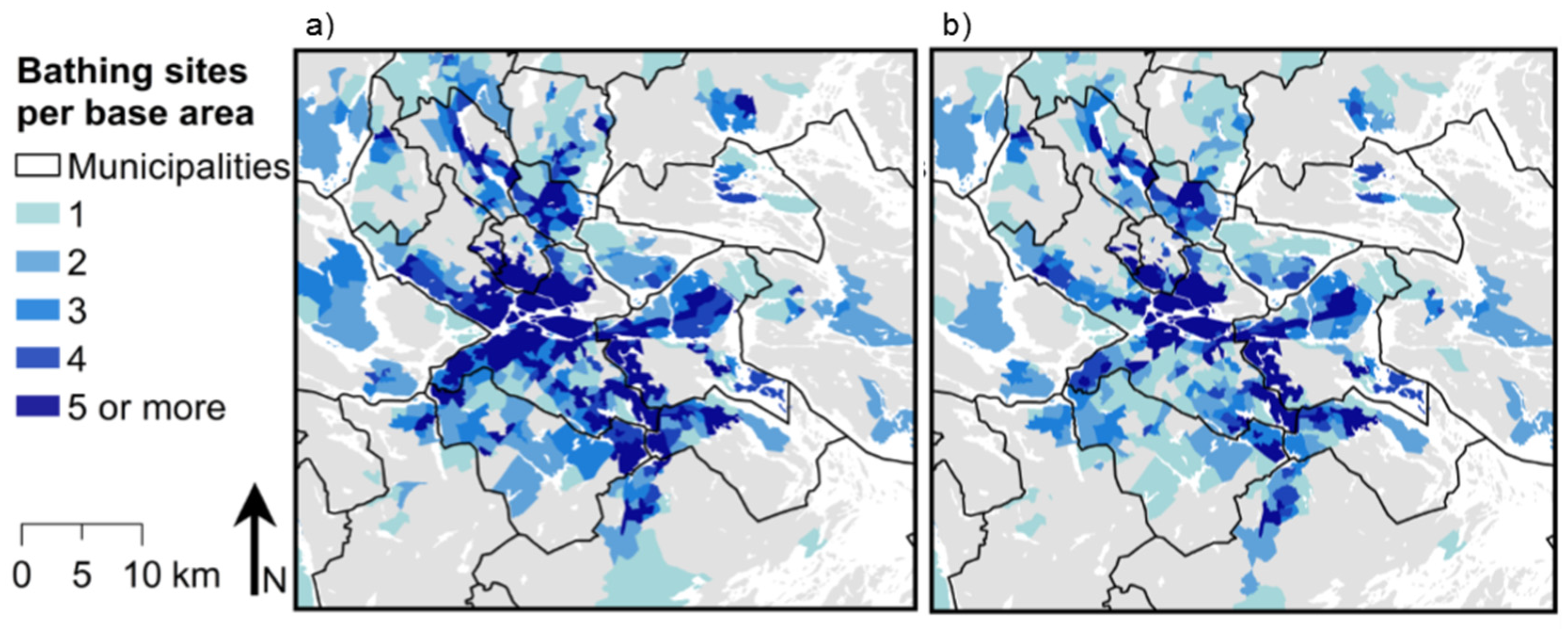
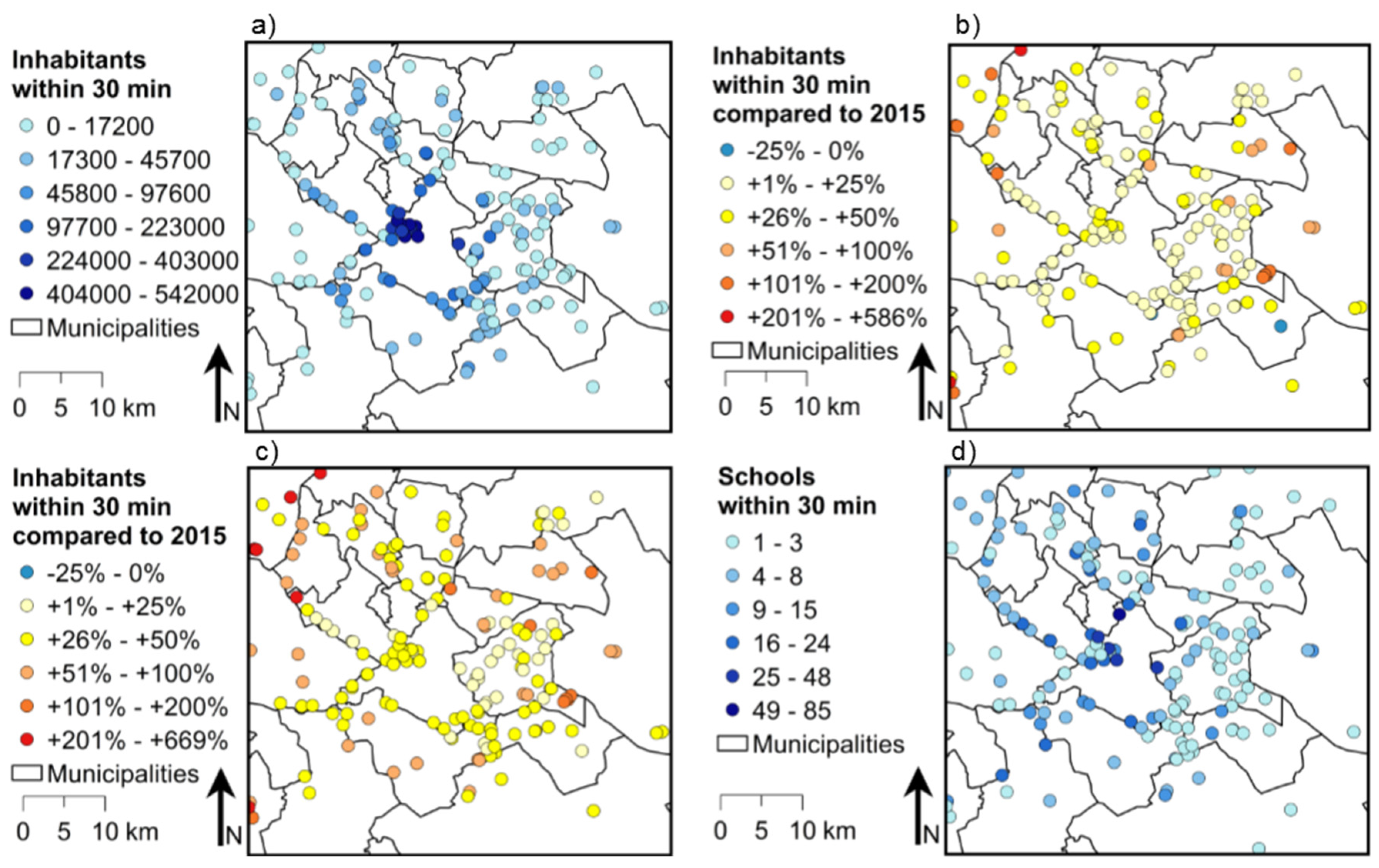
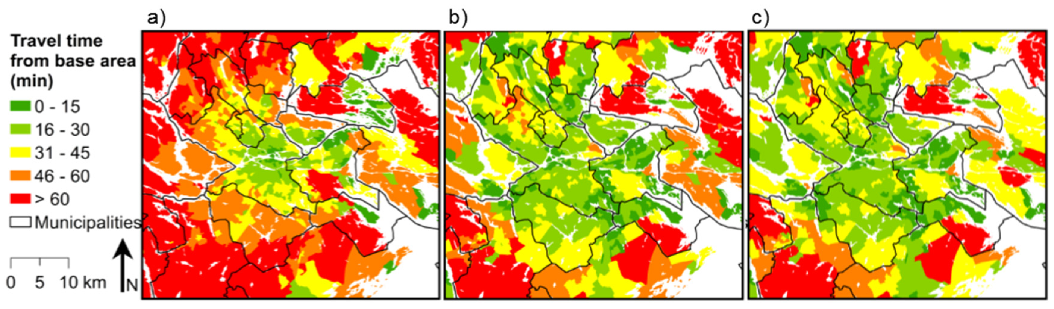
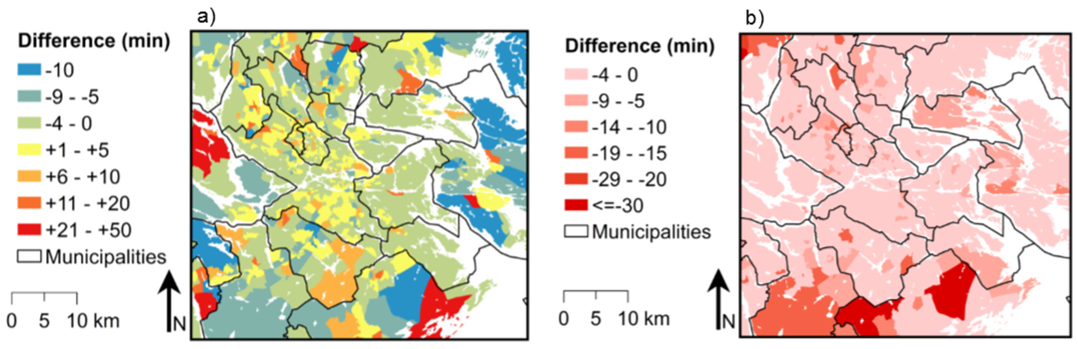
The network model was used to create matrices of the shortest travel time between origins and destinations. The origins and destinations were snapped to the closest street or public transport stop within 500 m. Points further away from the network were not considered accessible. Table 3 lists the matrices produced: their origins, destinations, time of the analysis and a description of the modelled situation. For each matrix, the analysis was run three times: 10 min before the time of analysis, at the time of the analysis and 10 min after. The minimum travel time from the three runs was used. This was done in order to account for the variation in travel time related to departure time.
The travel time matrices were processed into accessibility measures. The base areas were mapped according to the travel time to the closest destination at different points in time, to provide a comparison of access for base areas, in the form of a map of the spatial variation. In order to compare the possibility of variation, the number of accessible destinations (i.e., destinations within 30 min) was mapped. The bathing sites were mapped according to number of potential visitors in 2015, i.e., the number of inhabitants within 30 min travel time. In addition, the number of potential visitors in 2050 was mapped in relation to the 2015 value for both scenarios, as a way of visualising the predicted change in visitor pressure. As a measure of their accessibility for children, the bathing sites were mapped according to number of schools within 30 min.
The sensitivity of the model to some of the parameters set by the user was assessed. The model was used to find the closest destination for each base area centroid at 18:00 on a Thursday with a default walking speed of 70 m/min. It was also run once at the same time but with a walking speed of 80 m/min to assess sensitivity to walking speed, and once with the default walking speed but with the time set to 18:10 to assess the sensitivity to start time.

3. Results

The participants in the focus group workshop pointed out bathing sites and departure points for public archipelago boats as being among the most interesting WCES in the context of urban planning in the County of Stockholm (see Supplementary Materials). For well-planned activities, e.g., a trip to the archipelago or a day at the beach, a destination with a travel time of up to 1 h was considered accessible, while the corresponding limit was thought to be 30 min for activities that are more spontaneous, e.g., a walk or going bathing after work. As children constitute an important part of the population, the workshop participants thought that it would be interesting to perform the analysis with schools as origins, in addition to census units, as a way to assess the accessibility for children.
Figure 3a shows the access to the archipelago per base area represented by the travel time from the base area centroid to the closest public archipelago boat departure point, on a Sunday at 12:00, via the current public transport system. Green colour indicates a travel time up to 30 min, which is regarded as having good access in this study, yellow areas can be seen as having moderate access and orange and red indicate poor access. The proportions of the total population in the region with good access (travel time up to 30 min) to a public archipelago boat departure point in 2015 and 2050 are presented in Table 4. It should be noted that the predicted value for 2050 only considers population growth and not potential changes in the public transport system.
To capture the variation regarding choice of bathing site, the number of destinations within 30 min was estimated. Figure 4a shows the result per base area at 18:00 on a Thursday and Figure 4b the result at 12:00 on a Sunday. Centrally located base areas had more bathing sites within 30 min than those located farther out from the centre. The proportion of the total population of the region having good access to a bathing site in 2015 and 2050 are presented in Table 4.
The potential visitors to each bathing site at 18:00 on a Thursday, defined as the number of inhabitants within 30 min, are shown in Figure 5a. The potential visitors in 2050 for the baseline scenario and the high net immigration scenario, measured as the percentage change compared with 2015, are shown in Figure 5b,c. Destinations with a decrease in potential visitors compared with 2015 are shown in blue, while yellow and red indicate an increase. Figure 5d shows the bathing sites according to number of schools within 30 min travel time via the current public transport system, as a measure of how accessible they are for children.
Three different analyses of model sensitivity to parameter values were performed. Figure 6a shows how the travel time to the closest bathing site changed when the time for the analysis was changed from 18:00 to 18:10 on a Thursday. For many of the base areas, this changed the travel time by between 5 and 10 min and in some cases even more. Figure 6b shows the outcome when the model was run at the same time, 18:00 on a Thursday, but with the walking speed changed from 70 to 80 m/min. For most of the base areas, the effect on the travel time was less than 5 min, but there were also areas with greater differences.

4. Discussion

4.1. Accessiblity to WCES

As expected, travel times to the nearest destination were generally shorter in the most central parts of the Stockholm region and longer farther out from the centre (see Figure 3). However, there were many exceptions to this. Furthermore, as shown in Figure 4, the possibility to choose between several bathing sites within 30 min was mainly limited to the most central parts. This pattern can be explained by the structure of the public transport network combined with the proximity to the destinations. The centre of the City of Stockholm is situated around the land-lock between Lake Mälaren in the west and the Baltic Sea to the east, leading to a general proximity to shorelines. Regarding access to public archipelago boat stops, good access is strictly limited to central Stockholm and the eastern part of the County, located at the edge of the archipelago. In contrast, bathing sites are more evenly distributed across the county, resulting in more widespread access to these.
The structure of the public transport system was reflected in the results, so the farther out the location, the longer between public transport nodes linking to and from the city centre and the poorer the access in the transverse direction. The frequency of departures also decreases farther out from the inner city. Consequently, for someone starting close to central Stockholm there are good possibilities to move in many directions, while the possibilities decline with distance from the centre. Many of the areas identified as having good access to WCES that are not centrally located are most likely in the proximity of other public transport nodes.
The accessibility to public bathing sites with public transport would differ with time. As can be seen in Figure 3, there were visible differences in access to bathing sites between 18:00 on a Thursday and 12:00 on a Sunday. A corresponding pattern is also visible in Figure 4 where the number of accessible public bathing sites per base area is shown. The variation in the fraction of the total regional population having access to public bathing sites between these times amounted to around 6%–7% (Table 4) and can be explained by differences in the public transport schedule. Along many routes there are more frequent departures on weekday afternoons and in early evenings than on a Sunday. However, there are also some exceptions since there are examples of better access on a Sunday. The differences in access were found to be smaller (or none) in the most central parts of the county, due to a generally better supply of public transport.
The access to public archipelago boat stops was more limited than the access to public bathing sites, as can be seen in Figure 3. According to Table 4, around 35% of the total regional population would have access to these boats in 2015 compared with around 70% for bathing sites. In the case of boat stops, it was not seen as relevant to assess the effects of time variation, since the boat stop is only the entry point to the real destination. From one single stop it is possible to reach several destinations in the archipelago, and that is what would cause the main time variations. For both destination types, the access was predicted to decrease by 2050 and more so in the high net immigration scenario than the baseline scenario (Figure 5 and Table 4). The predicted population growth seemed to be greater in areas with poor access than in areas with good access, explaining the decrease in total access. This indicates a need for expansion of the public transport network as well as increasing the provision of publicly available WCES.
The number of potential visitors per bathing site in 2015 (Figure 5a) showed a pattern that can be explained by the concentration of inhabitants along with the high public transport supply in the most central parts of Stockholm, as well as the localisation of the central city close to the shoreline. Substantial changes could be predicted in the number of potential visitors in the scenarios for 2050. In the baseline scenario (Figure 5b) and the high net immigration scenario (Figure 5c), it was not the most central bathing sites, but rather semi-centrally located sites, that would have the highest increase in potential visitors compared with 2015. This might be interesting for planners in terms of whether these bathing sites can be extended and developed to handle an increased amount of visitors or complemented with new public bathing sites to ensure access to valuable WCES for the growing population. Regarding the accessibility for children to public bathing sites, the number of schools within 30 min travel time showed a similar pattern as for the total population (Figure 5d). The sites that were accessible from many schools were located in both central and semi-central parts of the region. Accessibility to ES for children is an essential sustainability perspective that should be further explored and supported in urban planning.

4.2. Model Properties and Development Potential

There are certain limitations of the model in the current study that may cause errors and uncertainties. Several of these limitations are intended to be overcome by further development of the model. One such limitation concerns input data. For instance, the data on bathing sites included all so-called EU bathing sites, which are those with the most visitors, along with those where the municipality has decided to monitor the water quality. However, data on these additional bathing sites managed by the municipality were only obtained from some of the municipalities concerned, and needs to be completed. In addition, there are of course in-official bathing sites not managed by the municipalities that could also be very important service providers. However, for urban planning on a regional level, the provision of public WCES such as bathing sites, accessible through walking and through the public transport network, is a major concern when planning for compact sustainable cities so these are still the most relevant in this context.
The data on streets made it possible to model walking between public transport stops, but may introduce another source of error. For example, some features included in the dataset represent roads that are not possible to walk along in reality, such as highways, and this national dataset may not include all local pedestrian trails and pass-ways. Moreover, the data on public archipelago boat stops only covered the public operator Waxholmsbolaget, but there are other private operators that also offer boat trips to the archipelago. In addition, recreational opportunities of Lake Mälaren, west of Stockholm, were not included.
An additional source of error was the fact that origins (base area centroids and schools) and destinations (bathing sites and archipelago boat stops) were allowed to snap to the network, in order to model them as reachable via the network, even if they were not located directly on the route. This represented a possible error of up to 500 m for the destination and origin, respectively. Assuming that it was possible to walk straight from the true location to the network, at a walking speed of 70 m/min, this would represent a possible error of up to 14 min per journey. For smaller base areas that were also more central, the travel time could be seen as relatively uniform and well represented by the centroid, but for larger base areas this error could be expected to be substantial.
Any model of accessibility through public transport is sensitive to its time schedule. The sensitivity of the model to start time was therefore analysed, so the model was run 10 min earlier and 10 min later as well as at the intended start time (e.g., 17:50, 18:00 and 18:10). The effect of delaying the departure time by only 10 min proved to be of relevance (see Figure 6a). For many of the origins, the travel time changed by more than 5 min and for some even more. This can be seen as a significant uncertainty when using a threshold of accessibility of 30 min. In reality, people tend to plan their trips and leave home at a time that minimises the waiting time at the first stop. The model, on the other hand, started timing the journey at one set time, resulting in some cases in an unrealistically long waiting time at the first stop.
The sensitivity of the walking speed parameter was also analysed (see Figure 6b). A decreased walking speed might just result in a few minutes difference, but could also result in the traveller missing the departure suggested by the journey planner and ending up on a later departure, resulting in a much longer travel time. In reality, walking speed varies between different individuals and 70 m/min, which is equal to 4.2 km/h, can be considered a fairly low speed. However, it could be preferable to set the speed quite low since a person capable of walking very fast can slow down, while the opposite might be impossible.
Assumptions that very much dominated the results of the accessibility analysis were the thresholds that were used, in particular the travel time threshold that separated an accessible destination from an inaccessible one. The accessibility thresholds used here were based on the results of the focus group discussions, but in reality individuals have their own perception of good accessibility. Regarding travel time, the current model cannot specify or limit the proportion of the total travel time that is spent walking or waiting time at stops. This functionality would be interesting to include, and is already developed in similar models [24,25].
The accessibility assessed in this study was the potential geographical accessibility. However, there may be differences between the potential and the actual accessibility, and people might not all choose to visit the destination within the shortest travel time. Moreover, there are other aspects to accessibility in addition to geography, such as social and cultural factors impacting upon people’s choices. The relationship between potential and actual visitors to a site may also be affected by quality aspects of the WCES as well as over-crowding. All these aspects are important for urban planning and should be further elaborated.
Most previous attempts to use multimodal network analysis to assess accessibility have not accounted for temporal variation in travel times, simply because standard GIS software has not yet supported this. However, Djurhuus et al. [24] and Salonen et al. [25] used public transport schedule data to make it possible to consider temporal variation. Both those studies also used a door-to-door approach, attempting to model all aspects of the journey, including getting to and from the first and last stop and walking between stops during transfers along the way. Overall, many sources of uncertainty were introduced in our GIS-based modelling approach. For a global sensitivity and uncertainty analysis of the model, several approaches are available (e.g., [47,48]).
The model presented by Salonen et al. [25] used the start and end point and queried an online journey planner outside GIS. In comparison, our GIS-based model has particularly great freedom as regards modifying the transport network. For example, the street network used for walking can be modified, walking speed can be changed and it is possible to include cycling or add public transport lines. These functionalities are available in the model described by Djurhuus et al. [24]. They programmed many parameters that in our GIS-based model were handled by already existing functionalities. In the current study, by snapping the start point to the closest street and then using the built-in least-cost path solver in the software, the possibility of walking to several stops was considered automatically. All functionalities were executed in GIS and no programming was required, only the combination of existing tools. In terms of planning support, this means that the model can be applied even by those without advanced programming skills.

4.3. The GIS-Based Accessibility Model as Planning Support

In this study, two types of destinations were used for the accessibility assessment, representing prioritised WCES. The choice of these was based on focus group discussions with planners from GRPA and representatives from SSNC (see Supplementary Materials). The choice of WCES was in line with the increased emphasis on ES in the new regional development plan [35], where water is expected to have an important role and the concept of ES should be applied when formulating objectives, discussing demands in the region and suggesting measures for a sustainable development. An emerging focus on WCES was also found in [49], in interviews with stakeholders working with the EU Water Framework Directive (WFD) in the same region, including municipal planners and politicians, NGOs and local farmers. For instance, it was stated that improved recreation values provided the main motivation for long-term commitment of the WFD work, and politicians were willing to make large investments primarily for the value associated with WCES.
In the regional planning for Stockholm, scenarios have been used for comparing possible future urban development trajectories [37,38], which can be used for discussions on demands and suggestions on measures concerning ES. In the current study, we used two such scenarios and the related population forecasts for 2050 [37], and in both the baseline scenario and the high immigration scenario we found an overall decrease in accessibility to WCES. This was caused by a larger predicted population growth within areas with poor access to WCES than in areas with good access. From a planning perspective, this can be interpreted as a demand for WCES that could be met either by expanding the public transport network and/or by providing additional public WCES. Both these measures can be tested with the GIS-based accessibility model.
In the analysis, we assumed that the same public transport network routes and schedules would exist in 2050, even when the population increased. In our model, it would be possible to plan for development of the public transport system by adding or excluding new routes and to test alternative solutions for that. The related changes in accessibility would be possible to assess, provided that GTFS data would be available for the intended transit line or by assuming a travel time for planned routes. Another assumption was that the locations of the destinations with publicly available WCES will remain the same in the scenarios for 2050. Likewise, it would be possible to plan for adding new such locations in suitable sites and to assess their accessibility.
In this study two types of origins, census base areas and elementary schools, were used for the accessibility assessment. The choice of these was also based on the focus group discussions with the stakeholders (see Supplementary Materials). This will enable to compare for instance socio-economic indices with the access to WCES, as an assessment of equality. One other WCES that was identified as important, and that could be included in further analyses, was waterfront walking paths. Access to other user movement-related ES could also be assessed. Another possibility would be to add cycling routes to the network, to define the routes on which it is possible to bring a bike, and assess accessibility for passengers bringing a bike.
For prioritised WCES service areas could be created, which provide access to a certain destination within a specified travel time, including potential beneficiaries of the service. In this way, different possible locations for a new WCES site could be evaluated, which should be useful in planning. The opposite could also be analysed; which destinations can be reached within a certain time from a certain point. This could be used, e.g., to assess which WCES people within a certain residential area could reach within a reasonable travel time. This type of analyses would add to the analysis of flows between ES supply and ES demand areas by, e.g., Bagstad et al. [50]. In addition, the GIS-based accessibility model could address citizens’ access to other urban functions such as work, healthcare, shopping facilities etc., simultaneously with the ES, which would be important for assessing overall sustainability of existing and planned development.
The GIS-based accessibility model could be applied at regional scale, as in the present case, or in municipal planning. It can be used in GIS or it can be integrated in modelling platforms such as the Land Evolution and impact Assessment Model (LEAM, [29]), which can simultaneously address a multitude of sustainability issues, including energy, transport and ecosystems [51]. The flexibility of the GIS-based accessibility model allows it to be easily updated, to include viewpoints and input from a wider group of stakeholders. This in return may result in different outputs and scenarios, i.e., on the most important WCES. Involving a wide range of actors in the planning may result in the development of innovative strategies for sustainable urban development. Additionally, the results could facilitate discussions between planners and stakeholders on future changes and alternative planning measures, and help further develop the planning for sustainable urban development.

5. Conclusions

With an increased emphasis on ES in the new regional development plan of the Stockholm region, the concept of ES should be applied when formulating objectives, discussing demands in the region and suggesting measures for a sustainable development. Specifically, water is expected to have an important role in the planning. Therefore, relevant planning support is required to plan for liveable, sustainable cities where ES, including WCES, are preserved and accessible through walking and public transport. To address this problem, the GIS-based accessibility model was developed to assess the geographical accessibility of WCES via walking and public transport, with input from stakeholders.
In the study area, access to public WCES was better in the central parts. Around 35% of the population of the County of Stockholm was shown to have good access to public archipelago boats, while the proportion was around 70% for bathing sites. This accessibility was predicted to decrease by 2050 if no changes would be made to the public transport system, due to the predicted population growth in areas with poor access to WCES. The parameters of the model can be changed to provide different scenarios, and facilitate discussion between planners on possible future urban development trajectories. The engagement of stakeholders can support better informed planning and decision-making and aid in the path for achieving urban sustainability.

Supplementary Materials

Supplementary materials are available online.

Acknowledgments

We gratefully acknowledge the funding from the Swedish Research Council for Environment, Agricultural Sciences and Spatial Planning (FORMAS), grants 2014-754 and 2015-133, and the support from the strategic research program Ekoklim at Stockholm University. The authors are grateful to three anonymous reviewers for valuable comments on earlier versions of the manuscript. GRPA helped with supervision of this work for which we are highly indebted.

Author Contributions

The authors Zahra Kalantari, Sara Khoshkar, Helena Falk, Vladimir Cvetkovic and Ulla Mörtberg contributed with ideas, research approach and article writing in order of appearance. Helena Falk and Sara Khoshkar led the workshop with stakeholders. Helena Falk is responsible for the model development work in this study, as a part of her MSc thesis on the Environmental Engineering and Sustainable Infrastructure (EESI) master’s program at KTH Royal Institute of Technology, Stockholm.

Conflicts of Interest

The authors declare no conflict of interest.

References

  1. United Nations. World Urbanization Prospects—The 2014 Revision; ST/ESA/SER.A/366; United Nations, Department of Economic and Social Affairs; Population Division: New York, NY, USA, 2015. [Google Scholar]
  2. Elmqvist, T.; Redman, S.; Barthel, S.; Costanza, R. History of urbanization and the missing ecology. In Urbanization, biodiversity and ecosystem services: Challenges and opportunities. In A Global Assessment; Elmqvist, T., Fragkias, M., Goodness, J., Güneralp, B., Marcotullio, P.J., McDonald, R.I., Parnell, S., Schewenius, M., Sendstad, M., Seto, K.C., et al., Eds.; Springer: Dordrecht, The Netherlands, 2013. [Google Scholar]
  3. Niemelä, J.; Breuste, J.H.; Guntenspergen, G.; McIntyre, N.E.; Elmqvist, T.; James, P. Urban Ecology: Patterns, Processes, and Applications; Oxford University Press: Oxford, UK, 2011. [Google Scholar]
  4. Tzoulas, K.; Korpela, K.; Venn, S.; Yli-Pelkonen, V.; Kaźmierczak, A.; Niemela, J.; James, P. Promoting ecosystem and human health in urban areas using green infrastructure: A literature review. Landsc. Urban Plan. 2007, 81, 167–178. [Google Scholar] [CrossRef]
  5. Bolund, P.; Hunhammar, S. Ecosystem services in urban areas. Ecol. Econ. 1999, 29, 293–301. [Google Scholar] [CrossRef]
  6. Gómez-Baggethun, E.; Barton, D.N. Classifying and valuing ecosystem services for urban planning. Ecol. Econ. 2013, 86, 235–245. [Google Scholar] [CrossRef]
  7. Sallis, J.F.; Floyd, M.F.; Rodriguez, D.; Saelens, B.E. Role of built environments in physical activity, obesity, and cardiovascular disease. Circulation 2012, 125, 729–737. [Google Scholar] [CrossRef] [PubMed]
  8. Evenson, K.R.; Wen, F.; Hillier, A.; Cohen, D.A. Assessing the contribution of parks to physical activity using gps and accelerometry. Med. Sci. Sports Exerc. 2013, 45, 1981–1987. [Google Scholar] [CrossRef] [PubMed]
  9. Wolch, J.R.; Byrne, J.; Newell, J.P. Urban green space, public health, and environmental justice: The challenge of making cities ‘just green enough’. Landsc. Urban Plan. 2014, 125, 234–244. [Google Scholar] [CrossRef]
  10. Milcu, A.I.; Hanspach, J.; Abson, D.; Fischer, J. Cultural ecosystem services: A literature review and prospects for future research. Ecol. Soc. 2013, 18, 44. [Google Scholar] [CrossRef]
  11. Organisation for Economic Cooperation and Development. The Compact City Concept in Today’s Urban Contexts; OECD Publishing: Paris, France, 2012; p. 284. [Google Scholar]
  12. World Bank. Planning Energy Efficient and Livable Cities—Energy Efficient Cities; Knowledge Series 022/14, Mayoral Guidance Note #6; Energy Sector Management Assistance Program (ESMAP); World Bank: Washington, DC, USA, 2014. [Google Scholar]
  13. Grimm, N.B.; Faeth, S.H.; Golubiewski, N.E.; Redman, C.L.; Wu, J.G.; Bai, X.M.; Briggs, J.M. Global change and the ecology of cities. Science 2008, 319, 756–760. [Google Scholar] [CrossRef] [PubMed]
  14. Cities Alliance. Liveable Cities: The Benefits of Urban Environmental Planning; The Cities Alliance: Washington DC, USA, 2007. [Google Scholar]
  15. European Environmental Agency. Ensuring Quality of Life in Europe’s Cities and Towns—Tackling the Environmental Challenges Driven by European and Global Change; EEA Report No 5/2009; European Environment Agency: Copenhagen, Denmark, 2009. [Google Scholar]
  16. Goldenberg, R.; Kalantari, Z.; Cvetkovic, V.; Mörtberg, U.; Deal, B.; Destouni, G. Distinction, quantification and mapping of potential and realized demand and supply of ecosystem services. Sci. Total Environ. 2017. in review. [Google Scholar]
  17. Paracchini, M.L.; Zulian, G.; Kopperoinen, L.; Maes, J.; Schägner, J.P.; Termansen, M.; Zandersen, M.; Perez-Soba, M.; Scholefield, P.A.; Bidoglio, G. Mapping cultural ecosystem services: A framework to assess the potential for outdoor recreation across the EU. Ecol. Indic. 2014, 45, 371–385. [Google Scholar] [CrossRef] [Green Version]
  18. Ala-Hulkko, T.; Kotavaara, O.; Alahuhta, J.; Helle, P.; Hjort, J. Introducing accessibility analysis in mapping cultural ecosystem services. Ecol. Indic. 2016, 66, 416–427. [Google Scholar] [CrossRef]
  19. Fisher, B.; Turner, R.K.; Morling, P. Defining and classifying ecosystem services for decision making. Ecol. Econ. 2009, 68, 643–653. [Google Scholar] [CrossRef]
  20. Syrbe, R.-U.; Walz, U. Spatial indicators for the assessment of ecosystem services: Providing, benefiting and connecting areas and landscape metrics. Ecol. Indic. 2012, 21, 80–88. [Google Scholar] [CrossRef]
  21. Costanza, R. Ecosystem services: Multiple classification systems are needed. Biol. Conserv. 2008, 141, 350–352. [Google Scholar] [CrossRef]
  22. Mörtberg, U.; Goldenberg, R.; Kalantari, Z.; Kordas, O.; Deal, B.; Balfors, B.; Cvekovic, V. Integrating ecosystem services in the assessment of urban energy trajectories—A study of the Stockholm region. Energy Policy 2017, 100, 338–349. [Google Scholar] [CrossRef]
  23. Brabyn, L.; Sutton, S. A population based assessment of the geographical accessibility of outdoor recreation opportunities in New Zealand. Appl. Geogr. 2013, 41, 124–131. [Google Scholar] [CrossRef]
  24. Djurhuus, S.; Hansen, H.S.; Aadahl, M.; Glümer, C. Building a multimodal network and determining individual accessibility by public transportation. Environ. Plan. B Plan. Des. 2016, 43, 210–227. [Google Scholar] [CrossRef]
  25. Salonen, M.; Toivonen, T. Modelling travel time in urban networks: Comparable measures for private car and public transport. J. Transp. Geogr. 2013, 31, 143–153. [Google Scholar] [CrossRef]
  26. Hunt, J.D.; Simmonds, D.C. Theory and application of an integrated land-use and transport modeling framework. Environ. Plan. B Plan. Des. 1992, 20, 221–244. [Google Scholar] [CrossRef]
  27. Lefevre, B. Long-term energy consumptions of urban transportation: A prospective simulation of “transport–land uses” policies in Bangalore. Energy Policy 2009, 37, 940–953. [Google Scholar] [CrossRef]
  28. Waddell, P.; Ulfarsson, G.F.; Franklin, J.P.; Lobb, J. Incorporating land use in metropolitan transportation planning. Transp. Res. Part A Policy Pract. 2007, 41, 382–410. [Google Scholar] [CrossRef]
  29. Deal, B.; Pallathucheril, V. Simulating regional futures: The land-use evolution and impact assessment model (LEAM). In Planning Support Systems for Cities and Regions; Braill, R., Ed.; Lincoln Institute of Land Policy: Cambridge, MA, USA, 2008; pp. 61–84. [Google Scholar]
  30. Geertman, S.; Stillwell, J. Planning support systems: An inventory of current practice. Comput. Environ. Urban Syst. 2004, 28, 291–310. [Google Scholar] [CrossRef]
  31. Uran, O.; Janssen, R. Why are spatial decision support systems not used? Some experiences from The Netherlands. Comput. Environ. Urban Syst. 2003, 27, 511–526. [Google Scholar] [CrossRef]
  32. Brömmelstroet, M. Performance of Planning Support Systems: What is it, and how do we report it? Comput. Environ. Urban Syst. 2013, 41, 299–308. [Google Scholar] [CrossRef]
  33. Pelzer, P.; Geertman, S.; Heijden, R.; Rouwette, E. The added value of Planning Support Systems: A practitioner’s perspective. Comput. Environ. Urban Syst. 2014, 48, 16–27. [Google Scholar] [CrossRef]
  34. Statistics Sweden. Population Statistics; Statistics Sweden: Stockholm, Sweden, 2016; Available online: www.scb.se (accessed on 10 June 2016).
  35. Growth and Regional Planning Administration. Stärkt Hållbarhet i Europas Mest Attraktiva Storstadsregion—Program för ny Regional Utvecklingsplan för Stockholmsregionen, RUFS 2050; Growth and Regional Planning Administration: Stockholm, Sweden, 2015.
  36. Growth and Regional Planning Administration. Områdesdatabasen; Growth and Regional Planning Administration: Stockholm, Sweden, 2016. Available online: www.rufs.se/kartor/rufs-2010/befolkning-och-sysselsatta/ (accessed on 10 June 2016). (In Swedish)
  37. Growth and Regional Planning Administration. Befolkning, Sysselsättning och Inkomster i Östra Mellansverige—Reviderade Framskrivningar Till år 2050; Growth and Regional Planning Administration: Stockholm, Sweden, 2012. (In Swedish)
  38. Office of Regional Planning. Förslag Till Regional Utvecklingsplan för Stockholmsregionen—RUFS 2010. Så Blir vi Europas Mest Attraktiva Storstadsregion; Office of Regional Planning: Stockholm, Sweden, 2010. (In Swedish)
  39. Growth and Regional Planning Administration. Regional Miljöstrategi för Vatten; Growth and Regional Planning Administration; Stockholm County Council: Stockholm, Sweden, 2013. (In Swedish)
  40. Swedish National Agency for Education. Skolenheter på Karta; Swedish National Agency for Education: Stockholm, Sweden, 2016. Available online: www.skolverket.se/skolformer/skoladresser/skolenheter-pa-karta-1.214055 (accessed on 10 June 2016). (In Swedish)
  41. Storstockholms Lokaltrafik. Trafiklab; Storstockholms Lokaltrafik: Stockholm, Sweden, 2016; Available online: www.trafiklab.se/ (accessed on 10 June 2016).
  42. Swedish Transport Agency. Väg- och Järnvägsdata; Swedish Transport Agency: Borlänge, Sweden, 2016; Available online: www.trafikverket.se/tjanster/data/vag--och-jarnvagsdata/ (accessed on 10 June 2016). (In Swedish)
  43. Swedish Agency for Marine and Water Management. Badplatsen—Badplatser och Badvattnets Kvalitet; Swedish Agency for Marine and Water Management: Göteborg, Sweden, 2016; Available online: www.havochvatten.se/hav/fiske--fritid/badvatten.html (accessed on 10 June 2016). (In Swedish)
  44. Lantmäteriet. GSD Overview Map; Lantmäteriet: Gävle, Sweden, 2016. [Google Scholar]
  45. Environmental Systems Research Institute. ArcGIS Desktop, 10; Environmental Systems Research Institute: Redlands, CA, USA, 2014. [Google Scholar]
  46. Morang, M.; Stevens, P. Add GTFS to a Network Dataset in ArcGIS Desktop; Environmental Systems Research Institute: Redlands, CA, USA, 2016. [Google Scholar]
  47. Lüdtke, N.; Panzeri, S.; Brown, M.; Broomhead, D.S.; Knowles, J.; Montemurro, M.A.; Kell, D.B. Information-theoretic sensitivity analysis: A general method for credit assignment in complex networks. J. R. Soc. Interface 2008, 5, 223–235. [Google Scholar] [CrossRef] [PubMed]
  48. Convertino, M.; Muñoz-Carpena, R.; Chu-Agor, M.L.; Kiker, G.A.; Linkov, I. Untangling drivers of species distributions: Global sensitivity and uncertainty analyses of MaxEnt. Environ. Model. Softw. 2014, 51, 296–309. [Google Scholar] [CrossRef]
  49. Dawson, L.; Persson, K.; Balfors, B.; Mörtberg, U.; Jarsjö, J. Collaborative learning for water sustainability: Knowledge generation and use in a Swedish catchment. Land Use Policy 2017. in review. [Google Scholar]
  50. Bagstad, K.J.; Johnson, G.W.; Voigt, B.; Villa, F. Spatial dynamics of ecosystem service flows: A comprehensive approach to quantifying actual services. Ecosyst. Serv. 2013, 4, 117–125. [Google Scholar] [CrossRef]
  51. Mörtberg, U.; Haas, J.; Zetterberg, A.; Franklin, J.; Jonsson, D.; Deal, B. Urban ecosystems and sustainable urban development: Analysing and assessing interacting systems in the Stockholm region. Urban Ecosyst. 2013, 16, 763–782. [Google Scholar] [CrossRef]
Figure 1. The study area embraced Stockholm County. The focus area for the discussion, the central and inner municipalities and their surroundings, are situated within the red square (a); while (b) shows the County of Stockholm in Sweden and surrounding countries. Spatial data © Lantmäteriet (I2014/00591) and [36], coordinate system SWEREF 99 TM.
Sustainability 09 00346 g001
Figure 2. Detail of the network that was built in GIS. Spatial data: [41,42], coordinate system SWEREF 99 TM.
Sustainability 09 00346 g002
Figure 3. Travel time to: (a) the closest archipelago boat stop on a Sunday 12:00; (b) bathing site on a Sunday 12:00; and (c) bathing site on a Thursday 18:00 from each base area. Spatial data © Lantmäteriet (I2014/00591) and [36], coordinate system SWEREF 99 TM.
Sustainability 09 00346 g003
Figure 4. Number of public bathing sites within 30 min travel time from each base area on: (a) a Thursday at 18:00; and (b) a Sunday at 12:00. Spatial data © Lantmäteriet (I2014/00591) and [36], coordinate system SWEREF 99 TM.
Sustainability 09 00346 g004
Figure 5. Inhabitants within 30 min travel time per bathing site on a Thursday 18:00 in: (a) 2015; and (b) 2050, assuming the baseline scenario; (c) 2050 assuming the high net immigration scenario; and (d) the number of schools within 30 min on a Thursday 14:00 in 2015. Spatial data © Lantmäteriet (I2014/00591) and [43], coordinate system SWEREF 99 TM.
Sustainability 09 00346 g005
Figure 6. Sensitivity expressed as the difference in travel time to the closest bathing site when varying: (a) start time from 18:00 to 18:10; and (b) walking speed from 70 to 80 m/min. Spatial data © Lantmäteriet (I2014/00591) and [36], coordinate system SWEREF 99 TM.
Sustainability 09 00346 g006
Table 1. Data that were used in the study.
DataDescription Source
Base areasPolygon shapefile with census units[36]
Census dataPopulation size per base area[36]
Population forecastsPredicted population size in 2050 per base area[37]
Elementary schoolsPoint location of all elementary schools in the region 2014[40]
Public transport networkGTFS data including spatial information and time tables for public transport operated by SL[41]
Street networkLine shapefile containing streets for cars, cycles and pedestrians[42]
Bathing sitesPoint location of water quality monitored bathing sites[43]
Bathing sitesPoint location of bathing sites managed by the municipality16 municipalities
Archipelago boat departure pointsGTFS data including location of stops operated by the public archipelago boat agency Waxholmsbolaget[41]
Map background elementsLand cover and municipality borders in vector format from the GSD overview map[44]
Table 2. The connectivity groups that were applied when constructing the network in GIS, within which movement between network components was permitted; “X” indicates membership of the connectivity group.
Network ComponentGroup 1Group 2Group 3
Public transport transit lines X
Streets X
Connectors between public transport stops and streets X
Public transport stops XX
Public transport stops snapped to closest streetXX
Table 3. The travel time matrices that were created.
Matrix AliasOriginsDestinationsTimeSituation
ABase area centroidsBathing sites within 30 min travel time of each originThursday 18:00Going swimming after a 9–5 work day
BBase area centroidsThe bathing site within the shortest travel time of each originThursday 18:00Going swimming after a 9–5 work day
CBase area centroidsBathing sites within 30 min travel time of each originSunday 12:00Going swimming in the weekend
DBase area centroidsThe bathing site within the shortest travel time of each originSunday 12:00Going swimming in the weekend
EBase area centroidsThe public archipelago boat stop within the shortest travel time of each originSunday 12:00Going on an archipelago trip in the weekend
FSchoolsBathing sites within 30 min travel time of each originThursday 14:00Going swimming after school with the youth leisure centre
Table 4. Fraction of the total regional population having good access to each destination type, i.e., public archipelago boat stops and public bathing sites.
20152050 Baseline Scenario2050 High Net Immigration Scenario
Public archipelago boat departure point35%34%33%
Bathing site Thursday 18:0073%71%69%
Bathing site Sunday 12:0067%64%63%

