State of the Art and Recent Advancements in the GIS-Based Approaches for Landfill Site Selection



Abstract
1. Introduction
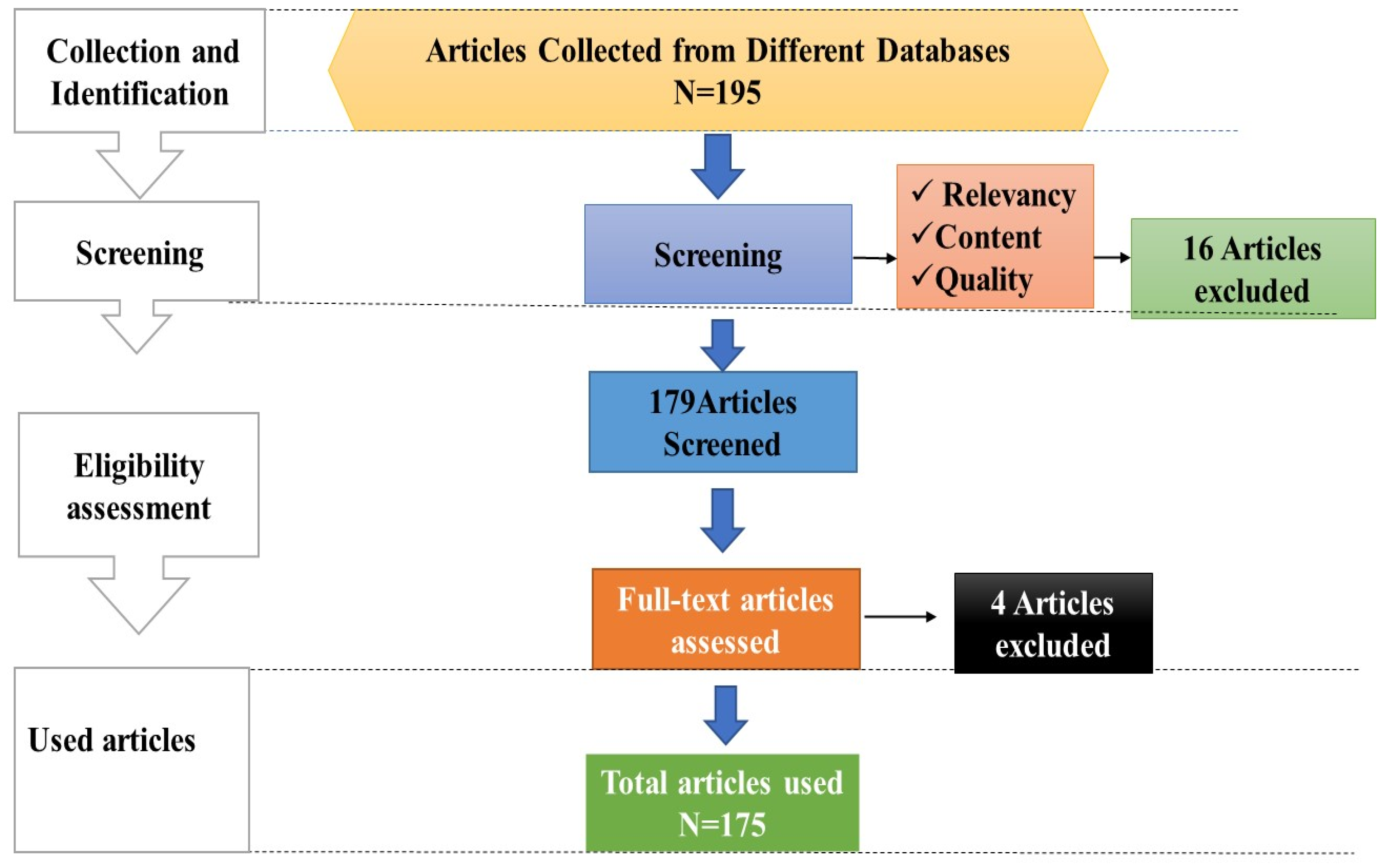
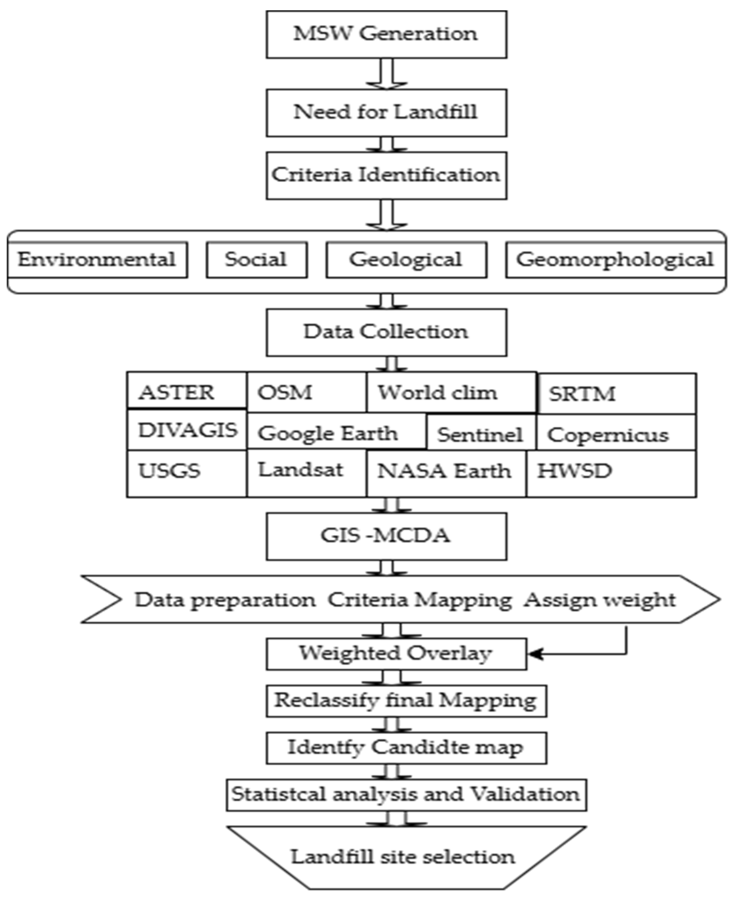
2. Methodology
3. Results
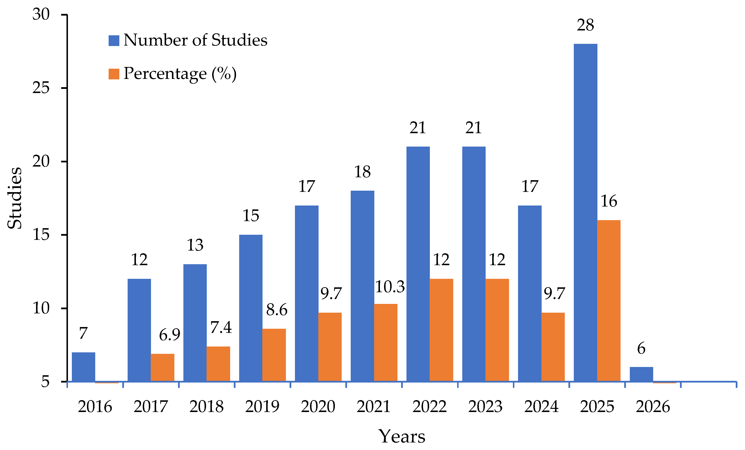
3.1. Annual Publication Trends of Review Studies
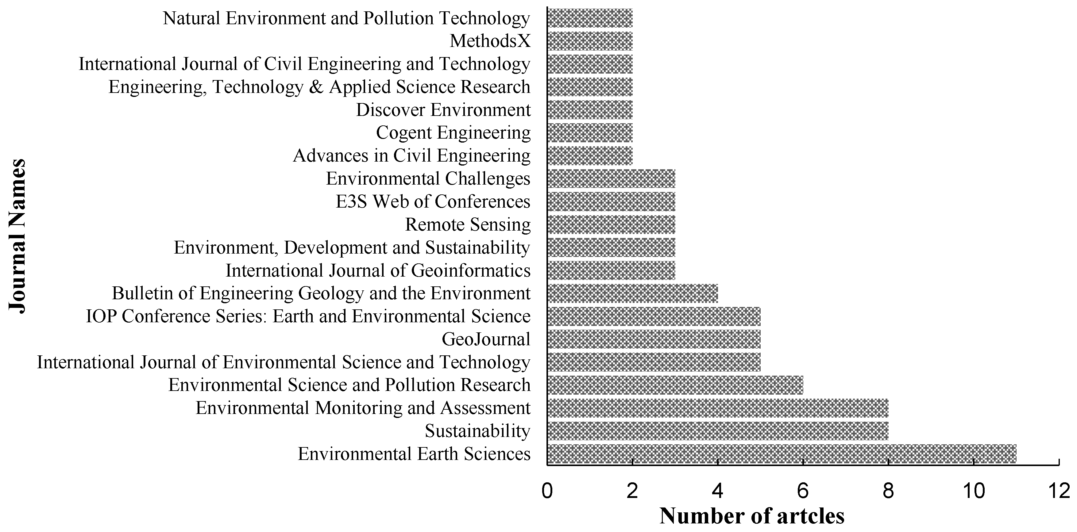
3.2. Journal Distribution of Reviewed Studies
3.3. Geographic Distribution of the Reviewed Studies
3.4. Landfill Siting Criteria and Exclusion Constraints
3.4.1. Environmental Criteria
3.4.2. Socio-Economic Criteria
3.4.3. Geological, Geomorphological and Topographic Criteria
3.5. Suitability Threshold Values for Landfill Suitability Selection
3.6. GIS Data Sources
3.7. Criteria Weighing Methods
3.7.1. AHP and Hierarchical Methods
3.7.2. Fuzzy Approaches and Distance Criteria
- –
- If x is fully an element of A, then
- –
- If x is not an element of A, then
- –
3.8. Multi-Criteria Decision Analysis (MCDA) Models
3.8.1. Studies and Frequency of MCDA
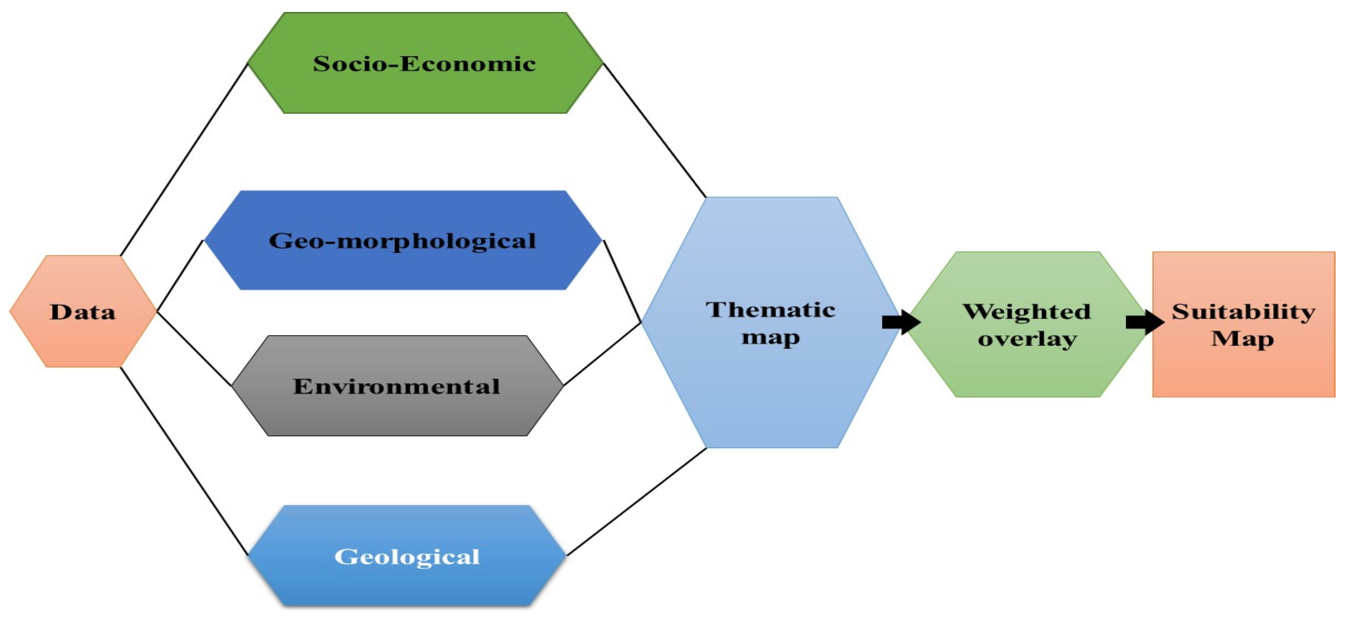
3.8.2. Land Suitability Assessment (Classical GIS Approaches)
3.8.3. Suitability Maps and Environmental Criteria
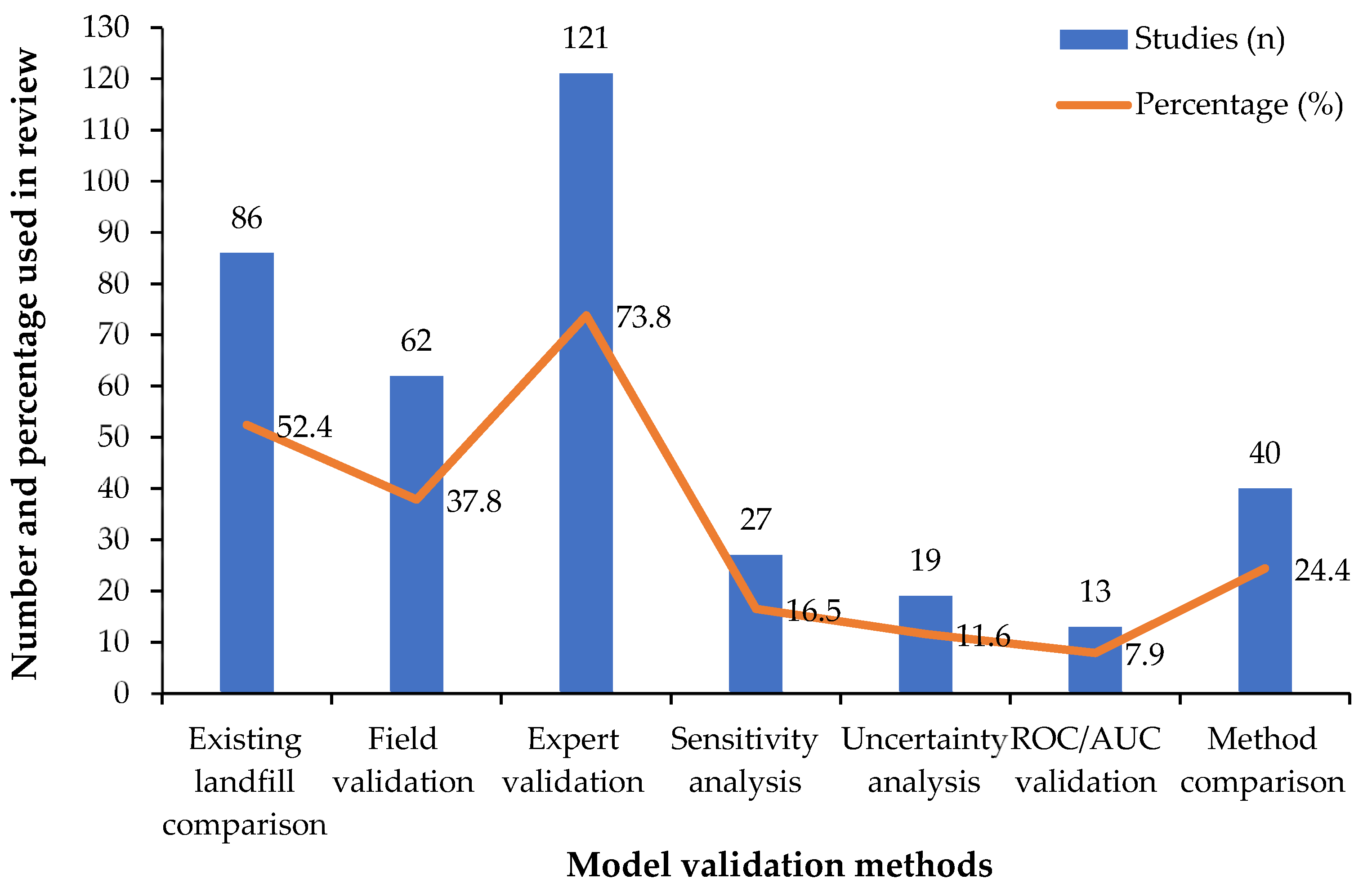
3.9. Model Validation, Sensitivity and Uncertainty Analysis
3.9.1. Model Validation
3.9.2. Sensitivity and Uncertainty Analysis
3.10. Practical Decision-Making Implications
3.11. Research Gaps and Future Directions
4. Conclusions
- ❖
- Research on landfills for waste management is still widespread in many parts of the world, and there has been an annual increase in studies in this study area, although their geographical distribution differs by country.
- ❖
- The majority of the research focuses on creating a suitability map and establishing suitability assessments before validating the selected landfill site location.
- ❖
- Methodological developments have progressed from conventional Boolean and weighted overlay methodologies to the current application of hybrid GIS-MCDA systems, characterised by wider application of optimisation algorithms, Fuzzy AHP, Fuzzy TOPSIS, MULTIMOORA, etc.
- ❖
- When integrated with GIS, the synergistic use of MCDA, which has recently increased in landfill site selection, was quite remarkable and deserves to be supported for further research.
- ❖
- Most studies basically depend on low-resolution DEMs and unreliable datasets, so increasing the accuracy and reliability of landfill-site selection will be enhanced by high-resolution DEMs, current geospatial datasets, and UAV-derived data.
- ❖
- To enhance transparency and trust in landfill siting models, it is essential to incorporate validation techniques, consistency checks, sensitivity, and uncertainty analysis.
- ❖
- Integrating GIS-MCDA with AI technologies like Random Forest, Machine Learning, ANN, and optimisation advancements can improve accuracy and reliability while minimising subjectivity.
- ❖
- Additionally, adopting a consistent threshold value for important criteria will enhance environmental, social, geological and geomorphological protection and reduce the diversity in criterion consideration among study areas within the same country.
Author Contributions
Funding
Institutional Review Board Statement
Informed Consent Statement
Data Availability Statement
Conflicts of Interest
Abbreviations
| AHP | Analytic Hierarchy Process |
| AI | Artificial Intelligence |
| ANP | Analytic Network Process |
| ASTER | Advanced Spaceborne Thermal Emission and Reflection Radiometre |
| AUC | Area Under the Curve |
| BWM | Best-Worst Method |
| CI | Consistency Index |
| CODAS | Combinative Distance-Based Assessment |
| COPRAS | Complex Proportional Assessment |
| CR | Consistency Ratio |
| DEM | Digital Elevation Model |
| DEMATEL | Decision-Making Trial and Evaluation Laboratory |
| DIVAGIS | Data-Interpolating Variational Analysis Geographic Information System |
| FAHP | Fuzzy Analytic Hierarchy Process |
| FAO | Food and Agriculture Organisation |
| FUCOM | Full Consistency Method |
| GIS | Geographic Information System |
| GSI | Geological Survey of India |
| GNSS | Global Navigation Satellite System |
| HWSD | Harmonised World Soil Database |
| LCSA | Life Cycle Sustainability Assessment |
| LSI | Land Suitability Index |
| LULC | Land Use/Land Cover |
| LST | Land Surface Temperature |
| MARCOS | Measurement of Alternatives and Ranking according to Compromise Solution |
| MCDA | Multi-Criteria Decision Analysis |
| MCDM | Multi-Criteria Decision-Making |
| MCE | Multi-Criteria Evaluation |
| ML | Machine Learning |
| MULTIMOORA | Multi-Objective Optimisation by Ratio Analysis plus the Full Multiplicative Form |
| MSW | Municipal Solid Waste |
| NASA | National Aeronautics and Space Administration |
| NDVI | Normalised Difference Vegetation Index |
| OSM | OpenStreetMap |
| OWA | Ordered Weighted Averaging |
| RI | Random Index |
| ROC | Receiver Operating Characteristic |
| RS | Remote Sensing |
| RSW | Ratio Scale Weighting |
| SAW | Simple Additive Weighting |
| SOI | Survey of India |
| SRS | Straight Rank Sum |
| SRTM | Shuttle Radar Topography Mission |
| SWARA | Stepwise Weight Assessment Ratio Analysis |
| TOPSIS | Technique for Order Preference by Similarity to Ideal Solution |
| TWI | Topographic Wetness Index |
| USGS | United States Geological Survey |
| VIKOR | VIKOR (VIseKriterijumska Optimizacija I Kompromisno Resenje) |
| WASPAS | Weighted Aggregated Sum Product Assessment |
| WLC | Weighted Linear Combination |
| WOA | Weighted Overlay Analysis |
References
- Devendra, R.; Ramakrishnaiah, C.R. Delineation of Landfill Sites for Four Different Regions of Bangalore City (India) Using GIS Integrated with Multiple Criteria Decision Analysis Technique: A Case Study. Environ. Conserv. J. 2025, 26, 1137–1149. [Google Scholar] [CrossRef] [Scilit]
- El Maguiri, A.; Kissi, B.; Idrissi, L.; Souabi, S. Landfill Site Selection Using GIS, Remote Sensing and Multicriteria Decision Analysis: Case of the City of Mohammedia, Morocco. Bull. Eng. Geol. Environ. 2016, 75, 1301–1309. [Google Scholar] [CrossRef] [Scilit]
- Kalisha, S.M.; Munthali, K.G. Multi-Factor GIS Modeling for Solid Waste Dumpsite Selection in Lilongwe, Malawi. Sustainability 2024, 16, 1202. [Google Scholar] [CrossRef] [Scilit]
- Nguyen, X.L.; Chou, T.Y.; Fang, Y.M.; Hoang, T.V.; Nguyen, Q.H. Optimal Position Proposal for Construction of Municipal Solid Waste Landfill Using an Approach of Fuzzy Set Theory and AHP in a GIS Environment: A Case Study in Hoai Duc District, Hanoi City, Vietnam. Int. J. Geoinform. 2020, 16, 23–32. [Google Scholar]
- Benferhat, T.; Saidou, A. Multi-Factor Gis Modeling for Solid Waste Dumpsite Selection in Boumedfaa, Algeria. Geoj. Tour. Geosites 2025, 61, 1563–1570. [Google Scholar] [CrossRef] [Scilit]
- Sureshkumar, M.; Sivakumar, R.; Nagarajan, M. Selection of Alternative Landfill Site in Kanchipuram, India by Using Gis and Multicriteria Decision Analysis. Appl. Ecol. Environ. Res. 2017, 15, 627–636. [Google Scholar] [CrossRef] [Scilit]
- Mihaliková, E.; Taušová, M.; Čulková, K. Public Expenses and Investment in Environmental Protection and Its Impact on Waste Management. Sustainability 2022, 14, 5270. [Google Scholar] [CrossRef] [Scilit]
- Dinnar, S.H.; Islam, S.; Singh, M.; Gaba, R. Future-Oriented Waste Management Technology for Ward-6, Bogura, Bangladesh—A Step towards Sustainability. Geomat. Environ. Eng. 2022, 16, 5–15. [Google Scholar] [CrossRef] [Scilit]
- Sharma, K.; Tiwari, R.; Wadhwani, A.K.; Chaturvedi, S. An Integrated GIS-MCDM Framework for Zoning, Ranking and Sensitivity Analysis of Municipal Landfill Sites. Sustain. Resilient Infrastruct. 2025, 10, 313–335. [Google Scholar] [CrossRef] [Scilit]
- Asif, K.; Chaudhry, M.N.; Ashraf, U.; Ali, I.; Ali, M. A GIS-Based Multi-Criteria Evaluation of Landfill Site Selection in Lahore, Pakistan. Pol. J. Environ. Stud. 2020, 29, 1511–1521. [Google Scholar] [CrossRef] [Scilit]
- Saha, P.; Roy, M. Identification of Municipal Solid Waste Disposal Sites for Sustainable Solid Waste Management in Cooch Behar Municipality, West Bengal: A RS-GIS Based MCDA Approach. Waste Manag. Bull. 2024, 2, 127–144. [Google Scholar] [CrossRef] [Scilit]
- Ayyildiz, E.; Erdogan, M. Literature Analysis of the Location Selection Studies Related to the Waste Facilities within MCDM Approaches. Environ. Sci. Pollut. Res. 2025, 32, 19574–19595. [Google Scholar] [CrossRef] [Scilit]
- Adewumi, J.R.; Ejeh, O.J.; Lasisi, K.H.; Ajibade, F.O. A GIS–AHP-Based Approach in Siting MSW Landfills in Lokoja, Nigeria. SN Appl. Sci. 2019, 1, 1528. [Google Scholar] [CrossRef] [Scilit]
- Aderoju, O.M.; Dias, G.A.; Gonçalves, A.J. A GIS-Based Analysis for Sanitary Landfill Sites in Abuja, Nigeria. Environ. Dev. Sustain. 2020, 22, 551–574. [Google Scholar] [CrossRef] [Scilit]
- Kahraman, C.; Cebi, S.; Onar, S.C.; Oztaysi, B. A Novel Trapezoidal Intuitionistic Fuzzy Information Axiom Approach: An Application to Multicriteria Landfill Site Selection. Eng. Appl. Artif. Intell. 2018, 67, 157–172. [Google Scholar] [CrossRef] [Scilit]
- Al Awadh, M.; Mallick, J. A Decision-Making Framework for Landfill Site Selection in Saudi Arabia Using Explainable Artificial Intelligence and Multi-Criteria Analysis. Environ. Technol. Innov. 2024, 33, 103464. [Google Scholar] [CrossRef] [Scilit]
- Ghoushchi, S.J.; Nasiri, B. Sustainable Landfill Site Selection for Hazardous Waste Using a GIS-Based MCDM Approach with G-Number Information. Environ. Dev. Sustain. 2025, 27, 22049–22080. [Google Scholar]
- Randazzo, L.; Cusumano, A.; Oliveri, G.; Di Stefano, P.; Renda, P.; Perricone, M.; Zarcone, G. Landfill Site Selection for Municipal Solid Waste by Using AHP Method in GIS Environment: Waste Management Decision-Support in Sicily (Italy). Detritus 2018, 2, 78–88. [Google Scholar] [CrossRef] [Scilit]
- Gontte, A. Geospatial-Based Landfill Site Selection in Developing Countries: An In-Depth Review of Theories, Methodologies, and Criteria. Int. J. Environ. Prot. Policy 2025, 13, 14–22. [Google Scholar] [CrossRef] [Scilit]
- Benezzine, G.; Zouhri, A.; Koulali, Y. AHP and GIS-Based Site Selection for a Sanitary Landfill: Case of Settat Province, Morocco. J. Ecol. Eng. 2022, 23, 1–13. [Google Scholar] [CrossRef] [Scilit]
- Ramu, P.; Santosh, B.S.; Praveen, S. An Integrated GIS-AHP Approach for Municipal Solid Waste Landfill Siting in Srikakulam District, Andhra Pradesh. Nat. Environ. Pollut. Technol. 2023, 22, 139–148. [Google Scholar] [CrossRef] [Scilit]
- Gallo, M. An Optimisation Model to Consider the NIMBY Syndrome within the Landfill Siting Problem. Sustainability 2019, 11, 3904. [Google Scholar] [CrossRef] [Scilit]
- Tella, A.; Mustafa, M.R.U.; Animashaun, G.; Adebisi, N.; Okolie, C.J.; Balogun, A.L.; Pham, Q.B.; Alani, R. Data-Driven Landfill Suitability Mapping in Lagos State Using GIS-Based Multi-Criteria Decision Making. Int. J. Environ. Sci. Technol. 2025, 22, 3181–3196. [Google Scholar] [CrossRef] [Scilit]
- Fatima, S.; Chaudhry, M.N.; Sharaai, A.H.; Ramli, M.F.; Ashaari, Z.H. Selection of Sanitary Landfill Site by Integrated Fuzzy AHP and GIS for Multan, Pakistan. World Rev. Sci. Technol. Sustain. Dev. 2021, 19, 149–169. [Google Scholar] [CrossRef] [Scilit]
- Abdelouhed, F.; Ahmed, A.; Abdellah, A.; Yassine, B.; Mohammed, I. GIS and Remote Sensing Coupled with Analytical Hierarchy Process (AHP) for the Selection of Appropriate Sites for Landfills: A Case Study in the Province of Ouarzazate, Morocco. J. Eng. Appl. Sci. 2022, 69, 19. [Google Scholar] [CrossRef] [Scilit]
- Yadav, A.; Kumar, P.; Kumar, A. Optimizing Landfill Site Selection and Solid Waste Management in Urbanizing Regions: A Geospatial Analysis of Rewari City, Haryana, India. Nat. Environ. Pollut. Technol. 2025, 24, B4206. [Google Scholar] [CrossRef] [Scilit]
- Elshaboury, N.; M. AlMetwaly, W.; Ali, E.; Eltoukhy, A.E.E. Sustainable Landfill Site Selection for Construction and Demolition Waste Using Magnitude-Based Fuzzy AHP and GIS Technologies. J. Geovis. Spat. Anal. 2025, 9, 27. [Google Scholar] [CrossRef] [Scilit]
- Parwoto, P.; Kasman, K.; Prasetyo, I.; Hadisoebroto, R.; Ashardiono, F. Alternative Location Analysis for Relocation of Waste Landfills in South Tangerang City. Indones. J. Urban Environ. Technol. 2025, 8, 265–279. [Google Scholar] [CrossRef] [Scilit]
- Bouroumine, Y.; Bahi, L.; Ouadif, L.; Elhachmi, D.; Ait Errouhi, A. Sitting MSW Landfill Combining GIS and Analytic Hierarchy Process (AHP), Case Study: Ajdir, Morocco. Int. J. Adv. Res. Eng. Technol. 2020, 11, 318–328. [Google Scholar] [CrossRef]
- Ali, S.A.; Ahmad, A. Suitability Analysis for Municipal Landfill Site Selection Using Fuzzy Analytic Hierarchy Process and Geospatial Technique. Environ. Earth Sci. 2020, 79, 227. [Google Scholar] [CrossRef] [Scilit]
- Sisay, G.; Gebre, S.L.; Getahun, K. GIS-Based Potential Landfill Site Selection Using MCDM-AHP Modeling of Gondar Town, Ethiopia. Afr. Geogr. Rev. 2021, 40, 105–124. [Google Scholar] [CrossRef] [Scilit]
- Yİldİrİm, V.; Memİsoglu, T.; Bedİroglu, S.; Colak, H.E. Selección de Sitio de Residuos Sólidos Municipales Uso Toma de Decisiones Multicriteria y Sig: Estudio de Caso de La Provincia de Bursa. Environ. Eng. Landsc. Manag. 2018, 26, 107–119. [Google Scholar]
- Redjem, A.; Benyahia, A.; Dougha, M.; Nouibat, B.; Hasbaia, M.; Ozer, A. Combining the Analytic Hierarchy Process With Gis for Landfill Site Selection: The Case of the Municipality of M’Sila, Algeria. Rom. J. Geogr. 2021, 65, 171–186. [Google Scholar]
- Asori, M.; Dogbey, E.; Morgan, A.K.; Ampofo, S.T.; Mpobi, R.K.J.; Katey, D. Application of GIS-Based Multi-Criteria Decision Making Analysis (GIS-MCDA) in Selecting Locations Most Suitable for Siting Engineered Landfills—The Case of Ashanti Region, Ghana. Manag. Environ. Qual. Int. J. 2022, 33, 800–826. [Google Scholar] [CrossRef] [Scilit]
- Mohsin, M.; Ali, S.A.; Shamim, S.K.; Ahmad, A. A GIS-Based Novel Approach for Suitable Sanitary Landfill Site Selection Using Integrated Fuzzy Analytic Hierarchy Process and Machine Learning Algorithms. Environ. Sci. Pollut. Res. 2022, 29, 31511–31540. [Google Scholar] [CrossRef] [Scilit]
- Elkhrachy, I.; Alhamami, A.; Alyami, S.H. Landfill Site Selection Using Multi-Criteria Decision Analysis, Remote Sensing Data, and Geographic Information System Tools in Najran City, Saudi Arabia. Remote Sens. 2023, 15, 3754. [Google Scholar] [CrossRef] [Scilit]
- Molla, M.B. Potential Landfill Site Selection for Solid Waste Disposal Using GIS-Based Multi-Criteria Decision Analysis (MCDA) in Yirgalem Town, Ethiopia. Cogent Eng. 2024, 11, 2297486. [Google Scholar] [CrossRef] [Scilit]
- Abujayyab, S.K.M.; Sanusi, M.; Yahya, A.S.; Alslaibi, T.M. GIS Modeling for Landfill Site Selection via Multi-Criteria Decision Analysis: A Systematic Review. In Proceedings of the International Conference on High Performance Compilation, Computing and Communications, Lumpur, Malaysia, 22–24 March 2017; Part F1280, pp. 33–38. [Google Scholar] [CrossRef] [Scilit]
- Djokanović, S.; Abolmasov, B.; Jevremović, D. GIS Application for Landfill Site Selection: A Case Study in Pančevo, Serbia. Bull. Eng. Geol. Environ. 2016, 75, 1273–1299. [Google Scholar] [CrossRef] [Scilit]
- Maafa, Z.; Badi, I. Integrating Multi-Criteria Decision-Making and Geographic Information Systems in Landfill Site Selection: A Comprehensive Review. Int. J. Sustain. Dev. Goals 2025, 1, 289–309. [Google Scholar] [CrossRef] [Scilit]
- Calis Boyaci, A.; Sisman, A. Location Selection for Waste Disposal Boxes: A Geographic Information Systems Based Pythagorean Fuzzy Multi-Criteria Decision Analysis. Int. J. Environ. Sci. Technol. 2024, 21, 8577–8592. [Google Scholar] [CrossRef] [Scilit]
- Bahrani, S.; Ebadi, T.; Ehsani, H.; Yousefi, H.; Maknoon, R. Modeling Landfill Site Selection by Multi-Criteria Decision Making and Fuzzy Functions in GIS, Case Study: Shabestar, Iran. Environ. Earth Sci. 2016, 75, 337. [Google Scholar] [CrossRef] [Scilit]
- Nguyen, D.T.; Truong, M.H.; Ngo, T.P.U.; Le, A.M.; Yamato, Y. GIS-Based Simulation for Landfill Site Selection in Mekong Delta: A Specific Application in Ben Tre Province. Remote Sens. 2022, 14, 5704. [Google Scholar] [CrossRef] [Scilit]
- Mat, N.A.; Benjamin, A.M.; Abdul-Rahman, S. A Review on Criteria and Decision-Making Techniques in Solving Landfill Site Selection Problems. J. Adv. Rev. Sci. Res. 2017, 37, 14–32. [Google Scholar]
- Despotakis, V.K.; Economopoulos, A.P. A Gis Model for Landfill Sitting. Glob. Nest J. 2019, 9, 29–34. [Google Scholar] [CrossRef] [Scilit]
- Alharbi, T.; El-Sorogy, A.S.; Rikan, N.; Algarni, H.M. Impact of Landfill Sites on Coastal Contamination Using GIS and Multivariate Analysis: A Case from Al-Qunfudhah in Western Saudi Arabia. Minerals 2025, 15, 802. [Google Scholar] [CrossRef] [Scilit]
- Miron, C.-O.; Oniga, V.-E.; Loghin, A.-M.; Nistor, S.; Chirila, C.; Lazar, A.-A.; Macovei, M. An In-Depth UAS-PPK Georeferencing Analysis at Different Flight Heights for an Urban Area. IEEE Access 2024, 12, 196533–196552. [Google Scholar] [CrossRef] [Scilit]
- Rane, N.L.; Mallick, S.K.; Saha, A.; Pande, C.B.; Rane, J.; Roy, R.; Alshehri, F.; Radwan, N. Appraisal on Suitable Landfill Site Selection for Municipal Solid Waste Disposal Using GIS and MIF Methods. Phys. Chem. Earth 2024, 134, 103591. [Google Scholar] [CrossRef] [Scilit]
- Mortazavi Chamchali, M.; Ghazifard, A. The Use of Fuzzy Logic Spatial Modeling via GIS for Landfill Site Selection (Case Study: Rudbar-Iran). Environ. Earth Sci. 2019, 78, 305. [Google Scholar] [CrossRef] [Scilit]
- Mortazavi Chamchali, M.; Mohebbi Tafreshi, A.; Mohebbi Tafreshi, G. Utilizing GIS Linked to AHP for Landfill Site Selection in Rudbar County of Iran. GeoJournal 2021, 86, 163–183. [Google Scholar] [CrossRef] [Scilit]
- Kareem, S.L.; Al-Mamoori, S.K.; Al-Maliki, L.A.; Al-Dulaimi, M.Q.; Al-Ansari, N. Optimum Location for Landfills Landfill Site Selection Using GIS Technique: Al-Naja City as a Case Study. Cogent Eng. 2021, 8, 1863171. [Google Scholar] [CrossRef] [Scilit]
- Abujayyab, S.K.M.; Ahamad, M.S.S.; Yahya, A.S.; Bashir, M.J.K.; Aziz, H.A. GIS Modelling for New Landfill Sites: Critical Review of Employed Criteria and Methods of Selection Criteria. IOP Conf. Ser. Earth Environ. Sci. 2016, 37, 012053. [Google Scholar] [CrossRef] [Scilit]
- Moumane, A.; Al Karkouri, J.; Batchi, M. Utilizing GIS, Remote Sensing, and AHP-Multi-Criteria Decision Analysis for Optimal Landfill Site Selection in Kenitra Province, Morocco: A Step towards Sustainable Development Goals. Discov. Environ. 2025, 3, 4. [Google Scholar] [CrossRef] [Scilit]
- Faisal, R.M.; Ahmed, M.F.A.D. GIS and AHP Based Modeling for Landfill Site Selection (Case Study: West Side of Mosul City). Sci. Rev. Eng. Environ. Sci. 2018, 27, 425–437. [Google Scholar] [CrossRef] [Scilit]
- Hmamou, M.; Chafi, T.; Ouhammou, I.; Khazaz, L. A Geospatial Analysis Utilizing AHP and GIS Was Conducted to Assess the Suitability of Landfill Sites for Solid Waste Disposal in the Province of Tangier-Assilah, Morocco. E3S Web Conf. 2023, 418, 03005. [Google Scholar] [CrossRef] [Scilit]
- Aksoy, E.; San, B.T. Geographical Information Systems (GIS) and Multi-Criteria Decision Analysis (MCDA) Integration for Sustainable Landfill Site Selection Considering Dynamic Data Source. Bull. Eng. Geol. Environ. 2019, 78, 779–791. [Google Scholar] [CrossRef] [Scilit]
- Cauba, A.G.; Badbad, M.D. Determining the Optimum Location for Landfill Site in Butuan City Using Gis-Based Analysis. In Proceedings of the 2021 IEEE International Geoscience and Remote Sensing Symposium IGARSS, Brussels, Belgium, 12 October 2021; pp. 3928–3931. [Google Scholar] [CrossRef] [Scilit]
- Islam, M.A.; Murshed, S.; Hasan, M. Selecting Suitable Landfill Site with Multi-Criteria Evaluation and GIS: A Case of Savar Upazila in Bangladesh. Arab. J. Geosci. 2020, 13, 952. [Google Scholar] [CrossRef] [Scilit]
- Bechroune, W.; Kherrour, L.; Belaid, L.; Goumrasa, A. GIS-MCDM Integrated Approach for Suitable Landfill Site Selection: A Case Study of the Southwestern Part of Bejaia Province, Algeria. Environ. Monit. Assess. 2024, 196, 1262. [Google Scholar] [CrossRef] [Scilit]
- Tobirov, O.; Nigmatov, A.; Abdunazarov, L.; Jobborov, A.; Abdinazarova, K. GIS-Based Multi-Criteria Evaluation for Landfill Site Selection in Kokand City and Adjacent Districts. InterCarto InterGIS 2025, 31, 574. [Google Scholar] [CrossRef] [Scilit]
- Desta, M.D.; Tesseme, T.; Yigezu, T.T.; Nigussie, A.B. Assessment of Landfill Site Suitability Using GIS, Remote Sensing, and the Multi-Criteria Decision-Making (AHP) Approach, Ethiopia. Geol. Ecol. Landsc. 2025, 9, 662–675. [Google Scholar] [CrossRef] [Scilit]
- Oyedele, A.A.; Omosekeji, A.E.; Ayeni, O.O.; Ewumi, T.O.; Ogunlana, F.O. Delineation of Landfill Sites for Municipal Solid Waste Management Using GIS. J. Hum. Earth Futur. 2022, 3, 321–332. [Google Scholar] [CrossRef] [Scilit]
- Muniraj, K.; Jesudhas, C.J.; Panneerselvam, B.; Subramani, A.K.; Devaraj, S.; Balasubramanian, A.; John, E. A GIS-Based Multi-Criteria Decision-Making Approach for Environmentally Sustainable Landfill Site Selection: A Case Study from an Indian Smart City. Innov. Infrastruct. Solut. 2026, 11, 121. [Google Scholar] [CrossRef] [Scilit]
- Tulun, Ş.; Gürbüz, E.; Arsu, T. Developing a GIS-Based Landfill Site Suitability Map for the Aksaray Province, Turkey. Environ. Earth Sci. 2021, 80, 310. [Google Scholar] [CrossRef] [Scilit]
- Aksoy, E.; San, B.T. Using MCDA and GIS for Landfill Site Selection: Central Districts of Antalya Province. Int. Arch. Photogramm. Remote Sens. Spat. Inf. Sci.-ISPRS Arch. 2016, 41, 151–157. [Google Scholar] [CrossRef] [Scilit]
- Ahmed, Z.A.; Suleimany, J.M.S.; Ahmed, I.D.; Saber, M.J. Investigation of Landfill Site Location Using GIS and Ranking Method: Pirmam District—A Case Study. Math. Model. Eng. Probl. 2025, 12, 3771–3782. [Google Scholar] [CrossRef] [Scilit]
- Alkaradaghi, K.; Ali, S.S.; Al-Ansari, N.; Laue, J.; Chabuk, A. Landfill Site Selection Using MCDM Methods and GIS in the Sulaimaniyah Governorate, Iraq. Sustainability 2019, 11, 4530. [Google Scholar] [CrossRef] [Scilit]
- Barzehkar, M.; Dinan, N.M.; Mazaheri, S.; Tayebi, R.M.; Brodie, G.I. Landfill Site Selection Using GIS-Based Multi-Criteria Evaluation (Case Study: SaharKhiz Region Located in Gilan Province in Iran). SN Appl. Sci. 2019, 1, 1082. [Google Scholar] [CrossRef] [Scilit]
- Ding, Z.; Zhu, M.; Wu, Z.; Fu, Y.; Liu, X. Combining AHP-Entropy Approach with GIS for Construction Waste Landfill Selection—A Case Study of Shenzhen. Int. J. Environ. Res. Public Health 2018, 15, 2254. [Google Scholar] [CrossRef] [Scilit]
- Mohammed, H.I.; Majid, Z.; Yamusa, Y.B. GIS Based Sanitary Landfill Suitability Analysis for Sustainable Solid Waste Disposal. IOP Conf. Ser. Earth Environ. Sci. 2019, 220, 012056. [Google Scholar] [CrossRef] [Scilit]
- Tayyeh, Z.Q.; Fadhullah, W. Integrated Modeling of Air Pollution Dispersion from Landfills and Waste Transportation Vehicles Using LandGEM and AERMOD: A GIS Approach. Environ. Monit. Assess. 2026, 198, 216. [Google Scholar] [CrossRef] [Scilit]
- Merdassi, A.; Guellouh, S.; Tebbi, F.Z.; Boumezrag, K. GIS-Based Selection of Appropriate Landfill Sites: The Case of Communal Grouping in Batna, Algeria. Eng. Technol. Appl. Sci. Res. 2023, 13, 10306–10309. [Google Scholar] [CrossRef] [Scilit]
- Balew, A.; Alemu, M.; Leul, Y.; Feye, T. Suitable Landfill Site Selection Using GIS-Based Multi-Criteria Decision Analysis and Evaluation in Robe Town, Ethiopia. GeoJournal 2022, 87, 895–920. [Google Scholar] [CrossRef] [Scilit]
- Kamdar, I.; Ali, S.; Bennui, A.; Techato, K.; Jutidamrongphan, W. Municipal Solid Waste Landfill Siting Using an Integrated GIS-AHP Approach: A Case Study from Songkhla, Thailand. Resour. Conserv. Recycl. 2019, 149, 220–235. [Google Scholar] [CrossRef] [Scilit]
- Karimi, H.; Amiri, S.; Huang, J.; Karimi, A. Integrating GIS and Multi-Criteria Decision Analysis for Landfill Site Selection, Case Study: Javanrood County in Iran. Int. J. Environ. Sci. Technol. 2019, 16, 7305–7318. [Google Scholar] [CrossRef] [Scilit]
- Dar, S.N.; Wani, M.A.; Shah, S.A.; Skinder, S. Identification of Suitable Landfill Site Based on GIS in Leh, Ladakh Region. GeoJournal 2019, 84, 1499–1513. [Google Scholar] [CrossRef] [Scilit]
- Mvula, R.L.S.; Mundike, J.; Nguvulu, A. Spatial Suitability Analysis for Site Selection of Municipal Solid Waste Landfill Using Hybrid GIS and MCDA Approach: The Case of Kitwe, Zambia. Sci. Afr. 2023, 21, e01885. [Google Scholar] [CrossRef] [Scilit]
- Ali, I.; Islam, A.; Ali, S.M.; Adnan, S. Identification and Selection of Suitable Landfill Sites Using GIS-Based Multi-Criteria Decision Analysis in the Peshawar District, Pakistan. Waste Manag. Res. 2023, 41, 608–619. [Google Scholar] [CrossRef] [Scilit]
- Pasalari, H.; Nodehi, R.N.; Mahvi, A.H.; Yaghmaeian, K.; Charrahi, Z. Landfill Site Selection Using a Hybrid System of AHP-Fuzzy in GIS Environment: A Case Study in Shiraz City, Iran. MethodsX 2019, 6, 1454–1466. [Google Scholar] [CrossRef] [Scilit]
- Kazuva, E.; Zhang, J.; Tong, Z.; Liu, X.P.; Memon, S.; Mhache, E. GIS- and MCD-Based Suitability Assessment for Optimized Location of Solid Waste Landfills in Dar Es Salaam, Tanzania. Environ. Sci. Pollut. Res. 2021, 28, 11259–11278. [Google Scholar] [CrossRef] [Scilit]
- Rezaeisabzevar, Y.; Bazargan, A.; Zohourian, B. Landfill Site Selection Using Multi Criteria Decision Making: Influential Factors for Comparing Locations. J. Environ. Sci. 2020, 93, 170–184. [Google Scholar] [CrossRef] [Scilit]
- Gołąb, J.; Borowski, Ł. The Use of Photogrammetry in Assessing the Stability of Escarpment of a Ditch Draining a Forest Road. Sylwan 2025, 169, 703–718. [Google Scholar] [CrossRef]
- Majid, M.; Mir, B.A. Landfill Site Selection Using GIS Based Multi Criteria Evaluation Technique. A Case Study of Srinagar City, India. Environ. Chall. 2021, 3, 100031. [Google Scholar] [CrossRef] [Scilit]
- Helal, A.H. Multicriteria Evaluation-GIS Integration Framework for Landfill Site Selection in Limited Space Regions: A Case Study in the West Bank. Adv. Civ. Eng. 2022, 2022, 9367256. [Google Scholar] [CrossRef] [Scilit]
- Al-Fares, R.A. Optimal Landfill Site Selection through the Application of GIS Analysis & Geotechnical Investigation. Ann. GIS 2024, 30, 383–409. [Google Scholar] [CrossRef] [Scilit]
- Mitab, B.T.; Hamdoon, R.M.; Sayl, K.N. Determination of Potential Sites for Landfill Using GIS and Remote Sensing Techniques: A Review. AIP Conf. Proc. 2024, 3105, 0213729. [Google Scholar] [CrossRef] [Scilit]
- Mitab, B.T.; Hamdoon, R.M.; Naba Sayl, K. Assessing Potential Landfill Sites Using GIS and Remote Sensing Techniques: A Case Study in Kirkuk, Iraq. Int. J. Des. Nat. Ecodyn. 2023, 18, 643–652. [Google Scholar] [CrossRef] [Scilit]
- Dararo, K.F.; Wedajo, G.K.; Mammo, S. Identification of Suitable Solid Waste Disposal Sites Using GIS and Multi-Criteria Decision Analysis Techniques in Burayu Sub City, Oromia Region, Ethiopia. Discov. Environ. 2025, 3, 88. [Google Scholar] [CrossRef] [Scilit]
- Ahire, V.; Behera, D.K.; Saxena, M.R.; Patil, S.; Endait, M.; Poduri, H. Potential Landfill Site Suitability Study for Environmental Sustainability Using GIS-Based Multi-Criteria Techniques for Nashik and Environs. Environ. Earth Sci. 2022, 81, 178. [Google Scholar] [CrossRef] [Scilit]
- Malo, S.K.; Mandal, D.; Chakraborty, K.; Saha, S. Identification of Potential Landfill Site Suitability for Urban Solid Waste Disposal of Balurghat Municipality of Dakshin Dinajpur District Using GIS and Multi-Criteria Decision-Making Approach. Discov. Appl. Sci. 2024, 6, 260. [Google Scholar] [CrossRef] [Scilit]
- Roy, D.; Das, S.; Paul, S.; Paul, S. An Assessment of Suitable Landfill Site Selection for Municipal Solid Waste Management by GIS-Based MCDA Technique in Siliguri Municipal Corporation Planning Area, West Bengal, India. Comput. Urban Sci. 2022, 2, 18. [Google Scholar] [CrossRef] [Scilit]
- Manjunatha, M.C.; Madhu, B.; Rekha, S.; Veena Murthy, N.; Veeresh, S.J.; Smitha, M.C.; Manasapriya Dwadasi, V.S.K.; Maheswar, S. Evaluation of Landfill Sites as per Mysuru-Nanjangud Master Plan (2031) Using Weighted Overlay Method in GIS Platform. Int. J. Geoinform. 2025, 21, 53–66. [Google Scholar] [CrossRef] [Scilit]
- Mohamed, N.A.; Asfaha, Y.G.; Wachemo, A.C. Integration of Multicriteria Decision Analysis and GIS for Evaluating the Site Suitability for the Landfill in Hargeisa City and Its Environs, Somaliland. Sustainability 2023, 15, 8192. [Google Scholar] [CrossRef] [Scilit]
- Chabuk, A.J.; Al-Ansari, N.; Laue, J. Site Selection Criteria and Design for Landfills in an Arid Area with Shallow Groundwater Depth; Springer International Publishing: Berlin/Heidelberg, Germany, 2021. [Google Scholar]
- Alkhuzaie, M.M.; Janna, H. Optimum Location for Landfills Sites Based on GIS Modeling for Al-Diwaniyah City, Iraq. Int. J. Civ. Eng. Technol. 2018, 9, 941–951. [Google Scholar]
- Rahmat, Z.G.; Niri, M.V.; Alavi, N.; Goudarzi, G.; Babaei, A.A.; Baboli, Z.; Hosseinzadeh, M. Landfill Site Selection Using GIS and AHP: A Case Study: Behbahan, Iran. KSCE J. Civ. Eng. 2017, 21, 111–118. [Google Scholar] [CrossRef] [Scilit]
- Parastatidou, E.; Voudouris, K.; Kazakis, N. Determination of Site Suitability for a Sanitary Landfill Using GIS and Boolean Logic: The Case of the Regional Unit of Chalkidiki, Northern Greece. Environments 2024, 11, 175. [Google Scholar] [CrossRef] [Scilit]
- Aslam, B.; Maqsoom, A.; Tahir, M.D.; Ullah, F.; Ur Rehman, M.S.; Albattah, M. Identifying and Ranking Landfill Sites for Municipal Solid Waste Management: An Integrated Remote Sensing and GIS Approach. Buildings 2022, 12, 605. [Google Scholar] [CrossRef] [Scilit]
- Hanine, M.; Boutkhoum, O.; Tikniouine, A.; Agouti, T. An Application of OLAP/GIS-Fuzzy AHP-TOPSIS Methodology for Decision Making: Location Selection for Landfill of Industrial Wastes as a Case Study. KSCE J. Civ. Eng. 2017, 21, 2074–2084. [Google Scholar] [CrossRef] [Scilit]
- Sheoran, S.K.; Parmar, V. Identification of Alternative Landfill Site Using QGIS in a Densely Populated Metropolitan Area. Quaest. Geogr. 2020, 39, 47–56. [Google Scholar] [CrossRef] [Scilit]
- Asefa, E.M.; Damtew, Y.T.; Barasa, K.B. Landfill Site Selection Using GIS Based Multicriteria Evaluation Technique in Harar City, Eastern Ethiopia. Environ. Health Insights 2021, 15, 1–14. [Google Scholar] [CrossRef] [Scilit]
- Makonyo, M.; Msabi, M.M. Potential Landfill Sites Selection Using GIS-Based Multi-Criteria Decision Analysis in Dodoma Capital City, Central Tanzania; Springer: Dordrecht, The Netherlands, 2022; Volume 87. [Google Scholar]
- Soleymani, M.; Asakereh, A.; Safieddin Ardebili, S.M. A GIS-Based Multi-Criteria Fuzzy Approach to Select a Suitable Location for a MSW-Based Power Plant and Landfill: A Case Study, Khuzestan Province, Iran. Environ. Monit. Assess. 2022, 194, 174. [Google Scholar] [CrossRef] [Scilit]
- Dereli, M.A.; Tercan, E. Comparison of GIS-Based Surrogate Weighting Methods for Multi-Directional Landfill Site Selection in West Mediterranean Planning Region in Turkey. Environ. Dev. Sustain. 2021, 23, 3438–3457. [Google Scholar] [CrossRef] [Scilit]
- Doboch Wanore, T.; Abera Angello, Z.; Menberu Fetanu, Z. Optimized Landfill Site Selection for Municipal Solid Waste by Integrating GIS and Multicriteria Decision Analysis (MCDA) Technique, Hossana Town, Southern Ethiopia. Heliyon 2023, 9, e21257. [Google Scholar] [CrossRef] [Scilit]
- Khodaparast, M.; Rajabi, A.M.; Edalat, A. Municipal Solid Waste Landfill Siting by Using GIS and Analytical Hierarchy Process (AHP): A Case Study in Qom City, Iran. Environ. Earth Sci. 2018, 77, 52. [Google Scholar] [CrossRef] [Scilit]
- İskender Soyaslan, İ. Landfill Site Suitability Analysis for Sustainable Solid Waste Management Using AHP and GIS in Burdur Lake Basin, Türkiye. MethodsX 2025, 15, 103555. [Google Scholar] [CrossRef] [Scilit]
- Barakat, A.; Hilali, A.; El Baghdadi, M.; Touhami, F. Landfill Site Selection with GIS-Based Multi-Criteria Evaluation Technique. A Case Study in Béni Mellal-Khouribga Region, Morocco. Environ. Earth Sci. 2017, 76, 413. [Google Scholar] [CrossRef] [Scilit]
- Santhosh, L.G.; Sivakumar Babu, G.L. Landfill Site Selection Based on Reliability Concepts Using the DRASTIC Method and AHP Integrated with GIS—A Case Study of Bengaluru City, India. Georisk 2018, 12, 234–252. [Google Scholar] [CrossRef] [Scilit]
- Elhag, M.; Bahrawi, J.A. Spatial Assessment of Landfill Sites Based on Remote Sensing and GIS Techniques in Tagarades, Greece. Desalin. Water Treat. 2017, 91, 395–401. [Google Scholar] [CrossRef] [Scilit]
- Mohammed, H.I.; Majid, Z.; Yamusa, Y.B.; Idris, K.M. Norhadija Darwin Sanitary Landfill Siting Using GIS and AHP. Eng. Technol. Appl. Sci. Res. 2019, 9, 4100–4104. [Google Scholar] [CrossRef] [Scilit]
- Dolui, S.; Sarkar, S. Identifying Potential Landfill Sites Using Multicriteria Evaluation Modeling and GIS Techniques for Kharagpur City of West Bengal, India. Environ. Chall. 2021, 5, 100243. [Google Scholar] [CrossRef] [Scilit]
- Tiwari, A.; Sreenivasan, G.; Sharma, V.K. Site Selection for Landfills Using GIS-Based Multi-Criteria Decision Analysis—A Case Study of National Capital Territory of Delhi, India. Int. J. Glob. Environ. Issues 2023, 22, 1–22. [Google Scholar] [CrossRef] [Scilit]
- Ajibade, F.O.; Olajire, O.O.; Ajibade, T.F.; Nwogwu, N.A.; Lasisi, K.H.; Alo, A.B.; Owolabi, T.A.; Adewumi, J.R. Combining Multicriteria Decision Analysis with GIS for Suitably Siting Landfills in a Nigerian State. Environ. Sustain. Indic. 2019, 3–4, 100010. [Google Scholar] [CrossRef] [Scilit]
- Singh, V.; Sardar, P.; Samadder, S.R. Landfill Site Selection in a Mining Dominated Area Using a Fuzzy AHP and DRASTIC Vulnerability Based Multicriteria Decision Analysis: A Case Study of Dhanbad, India. Environ. Monit. Assess. 2023, 195, 1172. [Google Scholar] [CrossRef] [Scilit]
- Majumder, S.; Fatma, R. Study on Site Selection of Municipal Solid Waste Landfill Based on FAHP and FTOPSIS Techniques in Barsat Municipality Area, West Bengal, India. Clean. Waste Syst. 2025, 11, 100258. [Google Scholar] [CrossRef] [Scilit]
- Oanh, N.T.; Thanh, P.T.; Long, N.B.; Chien, L.H.; Dinh, N.T.; Thom, T.T.; Bich, N.T.; Elshewy, M.A. Optimal Solid Waste Landfill Site Identification Employing GIS-Based Multi-Criteria Decision Analysis Within the Thach That District, Hanoi, Vietnam. Int. J. Geoinform. 2024, 20, 12–24. [Google Scholar] [CrossRef] [Scilit]
- da Purificação, C.G.C.; Leal, L.R.B.; Klammler, H.; Câmara, I.S.; de Almeida Nascimento, R.S.; Hatfield, K. GIS-based Multi-Criteria Decision Analysis for Landfill Allocation in a Tropical Metropolitan Region. Environ. Earth Sci. 2024, 83, 104. [Google Scholar] [CrossRef] [Scilit]
- Mozaffari, M.; Bemani, A.; Erfani, M.; Yarami, N.; Siyahati, G. Integration of LCSA and GIS-Based MCDM for Sustainable Landfill Site Selection: A Case Study. Environ. Monit. Assess. 2023, 195, 510. [Google Scholar] [CrossRef] [Scilit]
- Wu, T.H.; Chen, C.Y.; Huang, S.W.; Yu, T.T. An Integrated Decision Framework for Landfill Mining Site Selection Using GIS, Multi-Criteria Analysis, and Optimization Models. Socioecon. Plan. Sci. 2025, 99, 102220. [Google Scholar] [CrossRef] [Scilit]
- Birawida, A.B.; Daud, A.; Mallongi, A.; Silalahi, S.R.; Sila, N.; Todingan, M. Boolean and Spatial Analysis Using Gis To Determine Landfill Waste on Bunaken Island With an Environmental Health Approach. J. Kesehat. Lingkung. 2024, 16, 153–165. [Google Scholar] [CrossRef] [Scilit]
- Özkan, B.; Sarıçiçek, İ.; Özceylan, E. Evaluation of Landfill Sites Using GIS-Based MCDA with Hesitant Fuzzy Linguistic Term Sets. Environ. Sci. Pollut. Res. 2020, 27, 42908–42932. [Google Scholar] [CrossRef] [Scilit]
- Abdo, H.G.; Aljohani, T.H.D.; Almohamad, H.; Al-Dughairi, A.A.; Al-Mutiry, M. Sanitary Municipal Landfill Site Selection by Integration of GIS and Multi-Criteria Techniques for Environmental Sustainability in Safita Area, Tartous Governorate, Syria. Environ. Sci. Pollut. Res. 2023, 30, 30834–30854. [Google Scholar] [CrossRef] [Scilit]
- Stoyanova, E.; Vitov, V. Mapping Fast Fashion Landfills: Remote Sensing and GIS Approach to Analyze Textile Waste. Int. Arch. Photogramm. Remote Sens. Spat. Inf. Sci.-ISPRS Arch. 2025, 48, 1389–1395. [Google Scholar] [CrossRef] [Scilit]
- Ciski, M.; Rzasa, K.; Ogryzek, M. Use of GIS Tools in Sustainable Heritage Management-the Importance of Data Generalization in Spatial Modeling. Sustainability 2019, 11, 5616. [Google Scholar] [CrossRef] [Scilit]
- Mukomberanwa, N.T.; Chaipa, B.; Mutowo, G. GIS-Integrated Analytical Hierarchy Process (AHP) for Optimal Landfill Site Selection in Kadoma City, Zimbabwe. Sustain. Environ. 2025, 11, 2557727. [Google Scholar] [CrossRef] [Scilit]
- Kardoš, M.; Sačkov, I.; Tomaštík, J.; Basista, I.; Borowski, Ł.; Ferenčík, M. Elevation Accuracy of Forest Road Maps Derived from Aerial Imaging, Airborne Laser Scanning and Mobile Laser Scanning Data. Forests 2024, 15, 840. [Google Scholar] [CrossRef] [Scilit]
- Eghtesadifard, M.; Afkhami, P.; Bazyar, A. An Integrated Approach to the Selection of Municipal Solid Waste Landfills through GIS, K-Means and Multi-Criteria Decision Analysis. Environ. Res. 2020, 185, 109348. [Google Scholar] [CrossRef] [Scilit]
- Nistor, S.; Nastase, E.; Suba, N.-S.; Buda, A.S.; Paina, L.; Cîmpan, G.; Banaś, M. Analysis of Annual Seasonal Signal in GNSS Time Series from GNSS Station in the Western Part of Romania. J. Appl. Eng. Sci. 2025, 15, 317–322. [Google Scholar] [CrossRef] [Scilit]
- Irfan, M.; Houdayer, B.; Shah, H.; Koj, A.; Thomas, H. GIS-Based Investigation of Historic Landfill Sites in the Coastal Zones of Wales (UK). Euro-Mediterr. J. Environ. Integr. 2019, 4, 26. [Google Scholar] [CrossRef] [Scilit]
- Maciuk, K. Different Approaches in GLONASS Orbit Computation from Broadcast Ephemeris. Geod. Vestn. 2016, 60, 455–466. [Google Scholar] [CrossRef] [Scilit]
- Maciuk, K. Advantages of Combined GNSS Processing Involving a Limited Number of Visible Satellites. Sci. J. Silesian Univ. Technol. Ser. Transp. 2018, 98, 89–99. [Google Scholar] [CrossRef] [Scilit]
- Maciuk, K. Monitoring of Galileo On-Board Oscillators Variations, Disturbances & Noises. Measurement 2019, 147, 106843. [Google Scholar] [CrossRef] [Scilit]
- Owoseni, J.O. Landfill Site Suitability Mapping for Rational Development Planning: A GIS-Based Multi-Criteria Evaluation in Edo State, Nigeria. GeoJournal 2023, 88, 4603–4624. [Google Scholar] [CrossRef] [Scilit]
- Kharat, M.G.; Kamble, S.J.; Raut, R.D.; Kamble, S.S. Identification and Evaluation of Landfill Site Selection Criteria Using a Hybrid Fuzzy Delphi, Fuzzy AHP and DEMATEL Based Approach. Model. Earth Syst. Environ. 2016, 2, 98. [Google Scholar] [CrossRef] [Scilit]
- Chabuk, A.J.; Al-Ansari, N.; Hussain, H.M.; Knutsson, S.; Pusch, R. GIS-Based Assessment of Combined AHP and SAW Methods for Selecting Suitable Sites for Landfill in Al-Musayiab Qadhaa, Babylon, Iraq. Environ. Earth Sci. 2017, 76, 209. [Google Scholar] [CrossRef] [Scilit]
- Chabuk, A.; Al-Ansari, N.; Hussain, H.M.; Knutsson, S.; Pusch, R.; Laue, J. Combining GIS Applications and Method of Multi-Criteria Decision-Making (AHP) for Landfill Siting in Al-Hashimiyah Qadhaa, Babylon, Iraq. Sustainability 2017, 9, 1932. [Google Scholar] [CrossRef] [Scilit]
- Aguiñaga-Vallejo, M.; Paredes-Verduga, C.; Jácome-Cornejo, M.; Briones-Bitar, J.; Jaya-Montalvo, M.; Morante-Carballo, F.; Suárez-Zamora, S.; Aguilar-Aguilar, M.; Berrezueta, E.; Carrión-Mero, P. Multi-Criteria Site Selection for Solid Waste Disposal: Integration of Center of Gravity and AHP-GIS Analysis in Guayas, Ecuador. Front. Sustain. 2025, 6, 1647171. [Google Scholar] [CrossRef] [Scilit]
- Şimşek, K.; Alp, S. Evaluation of Landfill Site Selection by Combining Fuzzy Tools in GIS-Based Multi-Criteria Decision Analysis: A Case Study in Diyarbakır, Turkey. Sustainability 2022, 14, 9810. [Google Scholar] [CrossRef] [Scilit]
- Benezzine, G.; Zouhri, A.; Koulali, Y. Combining AHP with GIS for Landfill Site Selection: Case of the Ben Ahmed Circle. E3S Web Conf. 2021, 314, 20–22. [Google Scholar] [CrossRef] [Scilit]
- Muayad, M.; Janna, H. Geographic Information System (GIS) for Landfill Site Selection—A Review. IOP Conf. Ser. Earth Environ. Sci. 2023, 1232, 012004. [Google Scholar] [CrossRef] [Scilit]
- Armanuos, A.M.; Elgaafary, K.A.; Gado, T.A. Landfill Site Selection Using MCDM Methods and GIS in the Central Part of the Nile Delta, Egypt. Environ. Monit. Assess. 2023, 195, 1407. [Google Scholar] [CrossRef] [Scilit]
- Macalam, F.J.T.; Arreza, K.P.; Magpantay, A.T.; Rabaño, K.Y. Landfill Site Suitability Assessment Using Geographic Information System (GIS) and Analytic Hierarchy Process (AHP) in Butuan City, Philippines. J. Environ. Earth Sci. 2023, 5, 95–107. [Google Scholar] [CrossRef] [Scilit]
- Das, S.; Morshed, M.M.; Rafizul, I.M. Investigating Landfill Site Suitability Integrating GIS and Multicriteria Decision-Making Approaches in Khulna, Bangladesh. Int. J. Environ. Sci. Technol. 2025, 22, 9539–9558. [Google Scholar] [CrossRef] [Scilit]
- Osei, J.D.; Reed-Jones, Q.; Twumasi, Y.A.; Ning, Z.H. Assessing the Suitability of Existing Landfills in East Baton Rouge Parish Using Spatial Multi-Criteria Decision Making. Sustain. Anal. Model. 2025, 5, 100042. [Google Scholar] [CrossRef] [Scilit]
- Kang, Y.O.; Yabar, H.; Mizunoya, T.; Higano, Y. Optimal Landfill Site Selection Using ArcGIS Multi-Criteria Decision-Making (MCDM) and Analytic Hierarchy Process (AHP) for Kinshasa City. Environ. Chall. 2024, 14, 100826. [Google Scholar] [CrossRef] [Scilit]
- Rahimi, S.; Hafezalkotob, A.; Monavari, S.M.; Hafezalkotob, A.; Rahimi, R. Sustainable Landfill Site Selection for Municipal Solid Waste Based on a Hybrid Decision-Making Approach: Fuzzy Group BWM-MULTIMOORA-GIS. J. Clean. Prod. 2020, 248, 119186. [Google Scholar] [CrossRef] [Scilit]
- Heidari, M.; Jalali, S.H.; Saedi, B. Fuzzy MCDA and GIS Application to Sitting Landfill with Emphasis on Wind Properties and Fuzzy Operators’ Comparison in the Gharehchai Basin, Hamedan Province, Iran. Int. J. Environ. Sci. Technol. 2025, 22, 903–922. [Google Scholar] [CrossRef] [Scilit]
- Santisteban, J.A.Z.; López, R.S.; Rojas-Briceño, N.B.; Fernández, D.G.; Medina Medina, A.J.; Tuesta Trauco, K.M.; Rivera Fernandez, A.S.; Crisóstomo, J.L.; Oliva-Cruz, M.; Silva-López, J.O. Optimizing Landfill Site Selection Using Fuzzy-AHP and GIS for Sustainable Urban Planning. Civ. Eng. J. 2024, 10, 1698–1719. [Google Scholar] [CrossRef] [Scilit]
- Nguyen, D.M.T.; Robinson, D.T.; Zurbrügg, C.; Nguyen, T.H.T.; Dang, H.L.; Pham, V.M. Strategic Landfill Site Selection for Sustainable Waste Management in Phu Yen Province, Vietnam Using Geospatial Technologies. Ecol. Inform. 2025, 89, 103198. [Google Scholar] [CrossRef] [Scilit]
- Jyothi, S.R.; Singh, A.; Sarpal, S.S.; Mamatha, V.; Sheela, A.C.S.; Karna, A.K. Development of a GIS-Based Multi-Criteria Decision Analysis (MCDA) Model for Landfill Site Selection. Nat. Eng. Sci. 2025, 10, 288–300. [Google Scholar] [CrossRef] [Scilit]
- Chabok, M.; Asakereh, A.; Bahrami, H.; Jaafarzadeh, N.O. Selection of MSW Landfill Site by Fuzzy-AHP Approach Combined with GIS: Case Study in Ahvaz, Iran. Environ. Monit. Assess. 2020, 192, 433. [Google Scholar] [CrossRef] [Scilit]
- Cvetkov, V. A Weighting Approach of the Bivariate Regression; Springer: Berlin/Heidelberg, Germany, 2026; pp. 191–199. [Google Scholar]
- Özkan, B.; Özceylan, E.; Sarıçiçek, İ. GIS-Based MCDM Modeling for Landfill Site Suitability Analysis: A Comprehensive Review of the Literature. Environ. Sci. Pollut. Res. 2019, 26, 30711–30730. [Google Scholar] [CrossRef] [Scilit]
- Alrukaibi, D.; Alsulaili, A. GIS-Based Modeling for Appropriate Selection of Landfill Sites. J. Eng. Res. 2017, 5, 87–109. [Google Scholar] [CrossRef] [Scilit]
- Patil, S.A.; Endait, M.S. Siting of New Landfill for Municipal Solid Waste Using GIS and MCDA-A Review. Lect. Notes Civ. Eng. 2021, 134, 15–27. [Google Scholar] [CrossRef] [Scilit]
- Karakuş, C.B.; Demiroğlu, D.; Çoban, A.; Ulutaş, A. Evaluation of GIS-Based Multi-Criteria Decision-Making Methods for Sanitary Landfill Site Selection: The Case of Sivas City, Turkey. J. Mater. Cycles Waste Manag. 2020, 22, 254–272. [Google Scholar] [CrossRef] [Scilit]
- Badi, I.; Kridish, M. Landfill Site Selection Using a Novel FUCOM-CODAS Model: A Case Study in Libya. Sci. Afr. 2020, 9, e00537. [Google Scholar] [CrossRef] [Scilit]
- Alkaradaghi, K.; Ali, S.S.; Al-Ansari, N.; Laue, J. Combining GIS Applications and Analytic Hierarchy Process Method for Landfill Siting in Sulaimaniyah, Iraq; Springer International Publishing: Berlin/Heidelberg, Germany, 2021. [Google Scholar]
- Irawan, L.Y.; Sulaiman, R.; Herwanto, M.T.; Suprianto, A.; Prasetyo, W.E.; Pratiwi, D.A.; Huda, M.N.; Chairil, A. Intergrading Geological Resource Potential in Landfill Siting: A GIS-SMCE Approach in a Volcanic Landscape of Probolinggo, Indonesia. E3S Web Conf. 2025, 652, 02003. [Google Scholar] [CrossRef] [Scilit]
- Silva López, J.O.; Salas López, R.; Rojas Briceño, N.B.; Gómez Fernández, D.; Terrones Murga, R.E.; Iliquín Trigoso, D.; Barboza Castillo, E.; Oliva Cruz, M.; Barrena Gurbillón, M.Á. Analytic Hierarchy Process (AHP) for a Landfill Site Selection in Chachapoyas and Huancas (NW Peru): Modeling in a GIS-RS Environment. Adv. Civ. Eng. 2022, 2022, 9733322. [Google Scholar] [CrossRef] [Scilit]
- Chaturvedi, S.; Bhatt, N.; Shah, V.; Jodhani, K.H.; Patel, D.; Singh, S.K. Landfill Site Selection in Hilly Terrains: An Integrated RS-GIS Approach with AHP and VIKOR. Waste Manag. Bull. 2025, 3, 332–348. [Google Scholar] [CrossRef] [Scilit]
- Alkaradaghi, K.; Ali, S.S.; Al-Ansari, N.; Laue, J. Landfill Site Selection Using GIS and Multi-Criteria Decision-Making AHP and SAW Methods: A Case Study in Sulaimaniyah Governorate, Iraq. Engineering 2020, 12, 254–268. [Google Scholar] [CrossRef]
- Öner, G.; Akgün, H.; Koçkar, M.K.; Arslan Kelam, A. Municipal Landfill Site Selection Using TOPSIS Methodology: A Case Study for Polatlı, Ankara, Türkiye. Bull. Eng. Geol. Environ. 2025, 84, 126. [Google Scholar] [CrossRef] [Scilit]
- Mondal, S.; Mandal, B. GIS-Based Hybrid MCDM Technique for Optimal Landfill Site Selection: Advancing Sustainable Environmental Planning in the Sacred Landscape of Tarapith-Rampurhat, India. Phys. Chem. Earth 2026, 142, 104282. [Google Scholar] [CrossRef] [Scilit]
- Torkayesh, A.E.; Hashemkhani Zolfani, S.; Kahvand, M.; Khazaelpour, P. Landfill Location Selection for Healthcare Waste of Urban Areas Using Hybrid BWM-Grey MARCOS Model Based on GIS. Sustain. Cities Soc. 2021, 67, 102712. [Google Scholar] [CrossRef] [Scilit]
- Hassan, S.Z.; Sun, P.P.; Chen, J.; Reinhart, D. A Review of Landfill Odors Assessment: Advancing from Stationary Measurement to Spatiotemporal Monitoring. Waste Manag. 2025, 206, 115086. [Google Scholar] [CrossRef] [Scilit]
- Shukor, A.A.H.M.; Ishak, N.M.; Salleh, S.A.; Othman, F. Waste Management: Landfill Selection Using Gis and Analytical Hierarchy Process. IOP Conf. Ser. Earth Environ. Sci. 2024, 1316, 012003. [Google Scholar] [CrossRef] [Scilit]
- Khoshravesh, M.; Amirnejad, H.; Norooz Valashedi, R.; Ataie Solout, K. Multi-Criteria Spatial Analysis for Locating Waste Landfill with Boolean and Weighted Approach in Mazandaran Province, Iran. Environ. Water Eng. 2025, 11, 27–36. [Google Scholar] [CrossRef]
- Saatsaz, M.; Monsef, I.; Rahmani, M.; Ghods, A. Site Suitability Evaluation of an Old Operating Landfill Using AHP and GIS Techniques and Integrated Hydrogeological and Geophysical Surveys. Environ. Monit. Assess. 2018, 190, 144. [Google Scholar] [CrossRef] [Scilit]
- Kozioł, K.; Lupa, M.; Krawczyk, A. The Extended Structure of Multi-Resolution Database; Springer: Berlin/Heidelberg, Germany, 2014; pp. 435–443. [Google Scholar]
- Kalaiyarasan, K.; Santhosh, J. A Geospatial Approach to Identify Landfill Sites as Alternatives to Unsuitable Dumping Areas. Disaster Adv. 2025, 18, 19–30. [Google Scholar] [CrossRef] [Scilit]
- Akintorinwa, O.J.; Okoro, O.V. Combine Electrical Resistivity Method and Multi-Criteria GIS-Based Modeling for Landfill Site Selection in the Southwestern Nigeria. Environ. Earth Sci. 2019, 78, 162. [Google Scholar] [CrossRef] [Scilit]
- Sokoła-Szewioła, V.; Żogała, M. Management of the Post-Industrial and Degraded Lands Using ArcGIS: The Silesia Region Example. IOP Conf. Ser. Earth Environ. Sci. 2018, 198, 012015. [Google Scholar] [CrossRef] [Scilit]
- Kosydor, P.; Warchala, E.; Krawczyk, A.; Piórkowski, A. Determinants of Large-Scale Spatial Data Processing in Polish Mining. AIP Conf. Proc. 2020, 2209, 040007. [Google Scholar] [CrossRef] [Scilit]
- Hosseinzadeh, F.; Momeni, A.; Bagheri, R. Site Selection for Municipal Solid Waste Landfill in Coastal Area by Combining GIS–AHP Methods: A Case Study in East of Mazandaran Province, Iran. Iran. J. Sci. Technol.-Trans. Civ. Eng. 2024, 48, 511–524. [Google Scholar] [CrossRef] [Scilit]
- Susheen, A.; Bisai, A.; Patel, M.; Samadder, S.R. Study of Landfill Site Suitability and Sensitivity Analysis Using GIS-FAHP for Solid Waste Management: A Case Study in Ranchi, India. Front. Chem. Eng. 2026, 8, 1801053. [Google Scholar] [CrossRef] [Scilit]
- Chaturvedi, S.; Bhatt, N.; Shah, V.; Patel, D.; Jodhani, K.; Singh, S.K. Spatial Multi-Criteria Decision Framework for Landfill Site Selection Using AHP and CODAS with Sensitivity Analysis: A Case Study of Vadodara, India. J. Clean. Prod. 2026, 548, 147832. [Google Scholar] [CrossRef] [Scilit]
- Pawluszek, K.; Borkowski, A. Impact of DEM-Derived Factors and Analytical Hierarchy Process on Landslide Susceptibility Mapping in the Region of Rożnów Lake, Poland. Nat. Hazards 2017, 86, 919–952. [Google Scholar] [CrossRef] [Scilit]



| Rank | Country | Study | % (n = 175) | Rank | Country | Study | % (n = 175) |
|---|---|---|---|---|---|---|---|
| 1 | India | 30 | 17.14 | 15 | Egypt | 3 | 1.71 |
| 2 | Iran | 26 | 14.86 | 15 | Greece | 3 | 1.71 |
| 3 | Iraq | 13 | 7.43 | 15 | Indonesia | 3 | 1.71 |
| 3 | Turkey | 13 | 7.43 | 15 | Italy | 3 | 1.71 |
| 5 | Morocco | 10 | 5.71 | 20 | Kuwait | 2 | 1.14 |
| 6 | Ethiopia | 7 | 4.00 | 20 | Libya | 2 | 1.14 |
| 6 | Nigeria | 7 | 4.00 | 20 | Palestine | 2 | 1.14 |
| 8 | Vietnam | 6 | 3.43 | 20 | Peru | 2 | 1.14 |
| 9 | Algeria | 4 | 2.29 | 20 | Serbia | 2 | 1.14 |
| 9 | Ghana | 4 | 2.29 | 26 | Brazil | 1 | 0.57 |
| 9 | Malaysia | 4 | 2.29 | 26 | China | 1 | 0.57 |
| 9 | Pakistan | 4 | 2.29 | 26 | Ecuador | 1 | 0.57 |
| 9 | Saudi Arabia | 4 | 2.29 | 26 | Lithuania | 1 | 0.57 |
| 15 | Bangladesh | 3 | 1.71 | 26 | Philippines | 1 | 0.57 |
| Rank | Criterion | Articles | (%) | Rank | Criterion | Articles | (%) |
|---|---|---|---|---|---|---|---|
| 1 | Roads/Transportation | 164 | 93.7 | 19 | Aspect | 26 | 14.9 |
| 2 | Surface Water & Groundwater | 160 | 91.4 | 20 | Vegetation/NDVI | 24 | 13.7 |
| 3 | Slope | 148 | 84.6 | 21 | Power Lines | 22 | 12.6 |
| 4 | Residential Areas | 138 | 78.9 | 22 | Industrial Areas | 20 | 11.4 |
| 5 | (LULC) | 131 | 74.9 | 23 | Climate/Temperature | 19 | 10.9 |
| 6 | Soil | 91 | 52.0 | 24 | Administrative Boundaries | 17 | 9.7 |
| 7 | Elevation | 81 | 46.3 | 25 | Wind Direction | 17 | 9.7 |
| 8 | Geology | 77 | 44.0 | 26 | Archaeological | 17 | 9.7 |
| 9 | Protected Areas/Forests | 65 | 37.1 | 27 | Land Value/Economic Cost | 15 | 8.6 |
| 10 | Airports | 60 | 34.3 | 28 | Utility Infrastructure | 14 | 8.0 |
| 11 | Fault Lines/Seismic Zones | 54 | 30.9 | 29 | Parks/Recreation Areas | 12 | 6.9 |
| 12 | Railways | 48 | 27.4 | 30 | Bedrock Depth/Geomorphology | 11 | 6.3 |
| 13 | Population Density | 44 | 25.1 | 31 | Soil Permeability | 11 | 6.3 |
| 14 | Rainfall/Precipitation | 41 | 23.4 | 32 | Landfill Buffer Zones | 9 | 5.1 |
| 15 | Groundwater Depth | 36 | 20.6 | 33 | Economic Development Zones | 8 | 4.6 |
| 16 | Lineament Density | 33 | 18.9 | 34 | Tourism/Scenic Areas | 8 | 4.6 |
| 17 | Lithology | 30 | 17.1 | 35 | Soil Texture | 6 | 3.4 |
| 18 | Flood Risk/Floodplain | 28 | 16.0 | 36 | Protected Wetlands | 5 | 2.9 |
| Criterion | Unsuitable/Low Suitable Threshold | Highly Suitable Threshold | Justification | References |
|---|---|---|---|---|
| Road distance | <300 m | 1000–3000 m | Minimises nuisance while maintaining economical access to transportation. | [39,54,55,96,97,98] [21,31,55,84,97] [31,39,61,81,97] [29,31,39,54,83,99] [10,18,81,96,100] [17,39,50,80,96,101] [39,54,83,98] [9,17,67,98,101,102] [17,97,103,104,105] [39,72,97,99,106] [75,89,101,107] [14,64,90,108,109] [14,61,106,108] [29,55,61,72] [35,103,106,110] [39,83,98,111,112] [95,96,113,114] |
| Slope | >15° | 0–5° | Gentle slopes improve landfill stability and reduce erosion risk. | |
| Settlement distance | <1000 m | >2000 m | Reduces odour, noise, visual impacts, and public health concerns. | |
| River/Stream distance | <300–500 m | >1000–2000 m | Protects surface water from leachate contamination. | |
| Surface water | <500 m | >1500–2500 m | Minimises contamination of lakes and reservoirs. | |
| Groundwater wells | <300–400 m | >1500 m | Protects groundwater quality and drinking-water sources. | |
| Airport distance | <3000 m | >5000 m | Minimises bird-strike hazards. | |
| Elevation | <500 m or >2500 m | 500–2000 m | Moderate elevations generally provide better accessibility and drainage | |
| Fault distance | < 500 m | >1000–5000 m | Avoids tectonically unstable zones and fracture-controlled leachate migration. | |
| Protected areas | Within protected area | >1000 m buffer | Conserves biodiversity and satisfies environmental regulations. | |
| Land use/Land cover | Urban land, wetlands, forests | Bare land, shrubland, degraded land | Minimises land-use conflicts and ecological impacts. | |
| Geology | Highly permeable formations | Clay-rich or low-permeability formations | Restricts downward leachate migration. | |
| Soil type | Sandy soils | Clay/clay-loam soils | Clay provides a natural barrier against contaminant migration. | |
| Forest distance | Inside forest | >500–1000 m | Protects forest ecosystems and biodiversity. | |
| Wetlands | Inside wetland or <1000 m | >3000 m | Preserves ecologically sensitive wetland environments. | |
| Railway distance | <300 m | >300–1000 m | Reduces operational hazards and transportation conflicts. | |
| Drainage density | >3 km/km2 | <1 km/km2 | Lower drainage density reduces contaminant transport pathways. | |
| Flow accumulation | High | Low | Low flow accumulation minimises runoff concentration and flooding potential. | [11,115] [11,53] [73,77,113] [69,116,117,118] [49,67,119] [13,54,67,112] [29,97,99,120] [68,97,99,105] [121,122] [56,89,97] |
| (TWI) | >10 | <6 | Low TWI indicates drier conditions with lower leachate migration potential. | |
| Lineament density | >2 km/km2 | <1 km/km2 | Low fracture density reduces groundwater contamination risk. | |
| Population density | >1000 persons/km2 | <250 persons/km2 | Reduces exposure of nearby communities. | |
| Cultural/heritage sites | <1000 m | >2000 m | Protects archaeological and cultural heritage resources. | |
| Industrial areas | <500 m | 500–1500 m | Minimises land-use conflicts while maintaining accessibility. | |
| Power lines | <100 m | >300 m | Ensures operational safety and infrastructure protection. | |
| Coastline | <1000 m | >3000 m | Protects coastal ecosystems and marine water quality. | |
| Wildlife habitat | Within habitat | >1000 m | Minimises habitat disturbance and biodiversity loss. |
| No. | GIS Data Source | Studies | (%) | No. | GIS Data Source | Studies | (%) |
|---|---|---|---|---|---|---|---|
| 1 | DEM | 140 | 85.4 | 21 | Administrative Boundary | 14 | 8.5 |
| 2 | Geological Maps | 98 | 59.8 | 22 | Population Density | 12 | 7.3 |
| 3 | Road Network | 70 | 42.7 | 23 | Railway Network | 10 | 6.1 |
| 4 | Groundwater/Wells | 61 | 37.2 | 24 | Airport Locations | 9 | 5.5 |
| 5 | Soil Maps | 60 | 36.6 | 25 | Protected Area Map | 9 | 5.5 |
| 6 | LULC | 54 | 32.9 | 26 | Forest Cover | 8 | 4.9 |
| 7 | Landsat Imagery | 50 | 30.5 | 27 | Wetland Inventory | 8 | 4.9 |
| 8 | Rivers/Streams | 45 | 27.4 | 28 | NDVI | 8 | 4.9 |
| 9 | Surface Water Bodies | 41 | 25.0 | 29 | Geomorphology Map | 7 | 4.3 |
| 10 | Topographic Maps | 33 | 20.1 | 30 | ASTER DEM | 6 | 3.7 |
| 11 | Meteorological Data | 29 | 17.7 | 31 | Borehole Database | 5 | 3.0 |
| 12 | (OSM) | 29 | 17.7 | 32 | Climate Data | 5 | 3.0 |
| 13 | Protected Areas | 26 | 15.9 | 33 | LST | 4 | 2.4 |
| 14 | Settlement Data | 20 | 12.2 | 34 | Google Earth Imagery | 4 | 2.4 |
| 15 | Sentinel-2 Imagery | 20 | 12.2 | 35 | Geophysical Data | 3 | 1.8 |
| 16 | Hydrogeological Maps | 18 | 11.0 | 36 | UAV/Aerial Imagery | 2 | 1.2 |
| 17 | Fault Maps | 17 | 10.4 | 37 | SPOT Imagery | 2 | 1.2 |
| 18 | SRTM DEM | 17 | 10.4 | 38 | LiDAR Data | 2 | 1.2 |
| 19 | Digital Soil Database | 15 | 9.1 | 39 | WorldView Imagery | 1 | 0.6 |
| 20 | Drainage Network | 15 | 9.1 | 40 | QuickBird Imagery | 1 | 0.6 |
| MCDA | Main Uses | Advantages | Limitations | Assumptions | Data Requirements | Uncertainty Treatment | Ref. |
|---|---|---|---|---|---|---|---|
| AHP | Weighs criteria using pairwise comparisons and prioritises alternatives. | Simple, transparent, consistency check (CR), widely used, easy GIS integration. | Subjective judgments; assumes criteria independence; many comparisons for large problems. | Criteria are independent, and experts provide consistent judgments. | Moderate | Low | [18,159,160] |
| WLC | Combines standardised criteria using assigned weights to generate suitability maps. | Simple, computationally efficient, widely used in GIS. | Sensitive to weights; compensatory effect may mask unsuitable criteria. | Criteria contribute linearly to suitability. | Low | Low | [38,161,162] |
| OWA | Aggregates criteria while considering decision-maker risk preferences. | Flexible; manages trade-offs; reduces decision uncertainty. | More complex weighting than WLC. | Risk preferences can be quantified. | Moderate | Moderate | [34,73,81] |
| ANP | Evaluates interdependent criteria using a network structure. | Models complex relationships among criteria; more realistic than AHP. | Computationally intensive; requires many pairwise comparisons. | Criteria are interdependent. | High | Moderate | [59,81] |
| CODAS | Ranks alternatives according to their distance from the negative ideal solution. | Strong discrimination among alternatives; robust ranking. | Relatively new; limited landfill applications. | Greater distance indicates better alternatives. | Moderate | Moderate | [157,158] |
| SAW | Computes weighted sums of normalised criteria values. | Easy to implement and interpret; computationally efficient. | Sensitive to assigned weights; ignores criterion interactions. | Criteria contribute additively. | Low | Low | [96,163] |
| VIKOR | Produces compromise rankings among conflicting criteria. | Balances conflicting objectives; identifies compromise solutions. | Sensitive to parameter settings. | Decision seeks compromise among alternatives. | Moderate | Moderate | [162] |
| TOPSIS | Ranks alternatives based on distance from ideal and negative-ideal solutions. | Simple, intuitive, effective ranking of alternatives. | Sensitive to normalisation and criterion weights. | Ideal and negative-ideal solutions exist. | Moderate | Moderate | [11,164,165] |
| Boolean Logic | Applies binary inclusion/exclusion rules using logical operators. | Very simple; rapid constraint mapping; effective for exclusion analysis. | Produces only binary outcomes; no gradual suitability. | Threshold values are absolute. | Low | None | [98,118] |
| FAHP | Extends AHP using fuzzy numbers to model uncertain judgments. | Better represents uncertainty and vagueness; improves weighting reliability. | More computationally demanding than AHP. | Expert judgments are represented by fuzzy sets. | Moderate | High | [116,135,165] |
| BWM | Determines criterion weights using the best and worst criteria. | Fewer comparisons; high consistency; efficient weighting. | Requires reliable identification of best and worst criteria. | Experts can identify extreme criteria accurately. | Moderate | Moderate | [147,166] |
| FUCOM | Derives weights while maintaining full consistency. | Minimal comparisons; high consistency; reduces inconsistency. | Less commonly applied than AHP or BWM. | Criteria priorities are consistently ordered. | Moderate | Moderate | [158] |
| ML | Learns spatial patterns to predict landfill suitability from geospatial data. | Captures nonlinear relationships; automates prediction; high accuracy. | Requires large, high-quality datasets; limited interpretability. | Training data represent real-world conditions. | High | High | [35,167] |
| Rank | Method | Frequency (n) | Percentage (%) | Rank | Method | Frequency (n) | Percentage (%) |
|---|---|---|---|---|---|---|---|
| 1 | GIS | 164 | 100.00 | 12 | WASPAS | 4 | 2.44 |
| 2 | AHP | 104 | 63.41 | 13 | SWARA | 3 | 1.83 |
| 3 | WLC | 69 | 42.07 | 14 | ANP | 2 | 1.22 |
| 4 | Weighted Overlay | 33 | 20.12 | 15 | CODAS | 2 | 1.22 |
| 5 | Boolean Logic | 29 | 17.68 | 16 | BWM | 2 | 1.22 |
| 6 | FAHP | 23 | 14.02 | 17 | OWA | 1 | 0.61 |
| 7 | MCE | 15 | 9.15 | 18 | DEMATEL | 1 | 0.61 |
| 8 | Fuzzy Logic | 13 | 7.93 | 19 | COPRAS | 1 | 0.61 |
| 9 | SAW | 12 | 7.32 | 20 | FUCOM | 1 | 0.61 |
| 10 | TOPSIS | 9 | 5.49 | 21 | MARCOS | 1 | 0.61 |
| 11 | MULTIMOORA | 5 | 3.05 | 22 | VIKOR | 1 | 0.61 |
| MCDA | Aim of the Study | Result | Ref |
|---|---|---|---|
| AHP + Boolean | To address the high waste generation resulting from rapid urban expansion To mitigate the overburdening of the existing landfill facility To overcome the lack of socioeconomically and environmentally acceptable decentralised landfill sites To improve inefficient traditional approaches to landfill siting under increasing urban pressure | Identification of landfill suitability areas Development of a comprehensive landfill suitability map to support optimal site selection Demonstration of the effectiveness of GIS-based technologies in identifying optimal landfill locations | [117] |
| AHP + WLC | To address inefficient municipal solid waste management and the lack of scientifically selected landfill sites in the Peshawar District To determine the relative importance of multiple and diverse landfill siting criteria To develop an integrated spatial analysis approach for landfill site selection To minimise environmental degradation and public health risks associated with poor landfill siting | Suitable landfill sites were identified to support effective municipal solid waste (MSW) disposal. Systematic weighting of criteria was conducted, enabling more reliable decision-making. Land suitability was classified as very highly suitable, highly suitable, moderately suitable, low suitability, and unsuitable. | [78] |
| AHP + WSM | Provide a systematic and quantitative method for evaluating and selecting suitable waste disposal sites Encourage the selection of sustainable disposal sites for efficient environmental and urban management. Describe the benefits and drawbacks of using Multi-Criteria Decision Analysis (MCDA) and Geographic Information Systems (GIS) while choosing a landfill location. Encourage sustainable urban waste management by implementing a reliable, transparent, and adaptable framework that reduces environmental and societal impacts. | A landfill suitability ranking map was developed to identify the most preferred sites for development. Site rankings were determined based on the model’s effectiveness The recommended landfill site was evaluated against alternative sites | [151] |
| AHP + Fuzzy | To address the growing solid waste problem caused by urban expansion and increasing municipal waste generation. To develop effective management strategies for the substantial daily waste generated To improve the existing unsanitary municipal solid waste management practices. | Classify the area into suitability classes as high, moderate, low, and unsuitable. Proposed alternative sites are recommended. | [75] |
| AHP | There is currently no suitable municipal solid waste disposal site in the area. The study aimed to identify the most appropriate landfill location in Hosanna town, following the determination of the optimal municipal solid waste (MSW) management strategy. | Factor maps were combined to create an overall suitability map Generate the suitability maps and give a rank The proposed sites are easily accessible and manageable | [105] |
| AHP | Despite Siliguri city’s limited space, solid waste generation is increasing due to population growth in the study area. Without adequate management, landfill sites are periodically developing around the city. The current disposal sites in the Siliguri Municipal Corporation planning area are inefficient and poorly planned. | Identification of suitable sites, with other sites ranked as alternatives. The final suitability map was prepared using overlay analysis | [91] |
| AHP + WLC | The existing landfill site is located on the main riverbed and has poor geological conditions. As a result, it poses a high risk of water pollution due to leachate infiltration. Hazardous and non-hazardous waste is currently disposed of in landfills without any form of segregation in the area. This lack of segregation makes it difficult to identify an appropriate landfill location that is socially acceptable, economically viable, and environmentally sound | Site suitability for landfill locations was first evaluated. Landfill suitability maps were then developed using GIS. Next, selected sites were compared based on land size, proximity to settlements, and distance from the city centre. Finally, weights were assigned to each criterion, and the sites were ranked to identify the most suitable landfill location. | [10] |
| AHP | In the study area, non-scientific site selection for solid waste management has led to hygiene and environmental problems. A variety of analytical tools and methods have been developed to address these issues, but they have not solved the problem in the study area. The aim is to identify appropriate locations for solid waste disposal. | According to the study, there are three types of landfill site suitability: extremely, moderately, and marginally acceptable. The results promote sustainable urban management by improving knowledge of landfill -site selection in ways that are both socially and scientifically acceptable. | [37] |
| AHP + WLC | Insufficient waste-collection facilities lead to open dumping and burning. Due to inadequate upkeep, current disposal sites have a detrimental impact on public health. Inadequate solid waste management is frequently linked to urban flooding in the area. Solid waste management is now a top priority and a significant task. | The area was identified as the best location for engineered landfills. Eleven sites were found to be highly suitable for landfills. The hydrogeological and physical environmental sub-models had a significant impact on the final suitability model. | [34] |
| AHP | For a 35-year planning period, the analysis suggests a method for identifying suitable disposal locations. Most research often focuses on current circumstances, which can lead to inadequate solutions as parameters evolve. To guarantee sustainable solutions, future projections should be incorporated into GIS frameworks utilising MCDA. | AHP is emphasised as a straightforward but efficient approach to solving complicated issues. When choosing disposal sites, the study suggests considering population estimates and future solid waste volumes. To identify sustainable landfill locations, which are crucial for effective urban planning, the approach uses dynamic datasets. suggests conducting field research at the proposed disposal sites. | [56] |
| AHP | The city’s challenges in municipal solid waste management are due to limited financial resources and a lack of technological expertise. | The study evaluated landfill site suitability based on multi-criteria analysis. Land was classified into four suitability categories: most suitable, suitable, less suitable, and unsuitable. From a financial perspective, the selected site is considered viable because it is closest to the main source of MSW generation. | [144] |
| AHP | The study aims to provide a scientifically robust and socially acceptable waste management solution, as urban solid waste poses significant health risks. | The concept divides land suitability into various groups by combining scientific accuracy with societal acceptance. The study offers stakeholders and decision-makers a framework for addressing the challenges of selecting disposal sites. | [90] |
| AHP | Solid waste management is a challenge for the city of Dodoma. Finding possible landfill locations is the study’s main goal. The site selection procedure uses GIS-based multi-criteria decision analysis. | The study prioritises the selected land into categories of most suitable, suitable, and less suitable for solid waste disposal, using AHP and GIS. | [102] |
| AHP | Urban waste disposal poses a major challenge for city planners, driven by rapid population growth and increasing urbanisation. Identifying suitable sites for solid waste disposal is essential for effective and sustainable waste management. | Remote sensing data were used to construct layer maps for these criteria. Unsuitable, less suitable, moderately suitable, extremely suitable, and very highly suitable were the classifications given to the detected landfill. The findings provide reliable spatial data to inform new landfill locations. | [123] |
| AHP + WLC | Sanitary landfills can effectively reduce environmental degradation when they are properly sited and managed. In Edo State, Nigeria, waste mismanagement is exacerbated by population growth, urbanisation, and industrialisation, resulting in significant environmental concerns. | Thematic maps were overlaid to create a waste site suitability map The findings reveal significant changes in land use and expanding built-up areas, The identified dumpsites pose health, socio-economic, and environmental risks. | [134] |
| AHP | To address challenges of identifying suitable landfill sites and managing solid waste in Nashik, Maharashtra, India.The existing landfill site is closing, necessitating the identification of new sites. | Based on projected population growth, the amount of landfill space required in the coming years was estimated. The results demonstrate the effectiveness of the proposed approach in assisting city planners to select environmentally sustainable landfill sites, as illustrated in the potential landfill site map. | [89] |
| AHP | Proper waste disposal on suitable terrain is crucial for effective waste management and requires careful landfill site selection to minimise environmental impacts. | AHP analysis showed that land use carried the highest weight, while fault distance had the lowest, with a consistency ratio of 0.05. The study area was classified into four landfill suitability zones, with the majority of regions deemed unsuitable. Three candidate sites were assessed, and only one was selected because the others were too small or located too close to the beach. | [176] |
| AHP | Many random waste disposal sites exist, leading to environmental, health, and operational challenges. | By classifying and rating raster maps according to the chosen criteria, a final landfill-siting map was generated in GIS. Unsuitable areas and their buffer zones were excluded to expedite the selection of potential landfill locations. | [137] |
| AHP + TOPSIS | Nashik, a city in western India, has seen rapid urbanisation over the last 10 years, characterised by increased industrial activity and a growing urban population. The city’s municipal solid waste production has significantly increased as a result of these changes. | The study employed a methodology to identify and prioritise potential landfill sites in Nashik, India. After evaluating 16 potential locations, L10, which is close to Adagaon, was selected as the best. The method of criterion analysis provides a systematic basis for selecting sustainable disposal sites. | [9] |
Disclaimer/Publisher’s Note: The statements, opinions and data contained in all publications are solely those of the individual author(s) and contributor(s) and not of MDPI and/or the editor(s). MDPI and/or the editor(s) disclaim responsibility for any injury to people or property resulting from any ideas, methods, instructions or products referred to in the content. |
© 2026 by the authors. Licensee MDPI, Basel, Switzerland. This article is an open access article distributed under the terms and conditions of the Creative Commons Attribution (CC BY) license.
Share and Cite
Bidira, F.; Jakubiak, M.; Maciuk, K. State of the Art and Recent Advancements in the GIS-Based Approaches for Landfill Site Selection. Sustainability 2026, 18, 9080. https://doi.org/10.3390/su18179080
Bidira F, Jakubiak M, Maciuk K. State of the Art and Recent Advancements in the GIS-Based Approaches for Landfill Site Selection. Sustainability. 2026; 18(17):9080. https://doi.org/10.3390/su18179080
Chicago/Turabian StyleBidira, Firomsa, Mateusz Jakubiak, and Kamil Maciuk. 2026. "State of the Art and Recent Advancements in the GIS-Based Approaches for Landfill Site Selection" Sustainability 18, no. 17: 9080. https://doi.org/10.3390/su18179080
APA StyleBidira, F., Jakubiak, M., & Maciuk, K. (2026). State of the Art and Recent Advancements in the GIS-Based Approaches for Landfill Site Selection. Sustainability, 18(17), 9080. https://doi.org/10.3390/su18179080