Article

Multi-Scale Spatiotemporal Evolution of Urban Green Development Level in China Under the SDGs Framework (2009–2021)

1
Power China Huadong Engineering Corporation, Hangzhou 311122, China
2
State Key Laboratory of Soil Pollution Control and Safety, Zhejiang University, Hangzhou 310058, China
3
College of Environmental and Resource Sciences, Zhejiang University, Hangzhou 310058, China
4
Xiaoshan Institute of Agricultural Science and Technology, Hangzhou 311200, China
5
Zhejiang Institute of Geosciences, Hangzhou 310007, China
*
Author to whom correspondence should be addressed.
These authors contributed equally to this work.
Sustainability 2026, 18(17), 8783; https://doi.org/10.3390/su18178783
Submission received: 16 June 2026 / Revised: 15 August 2026 / Accepted: 18 August 2026 / Published: 27 August 2026

Abstract

In the context of the global implementation of the United Nations 2030 Sustainable Development Goals (SDGs), urban green development serves as a core practical pathway to advance SDG8 (Decent Work and Economic Growth), SDG11 (Sustainable Cities and Communities), and SDG15 (Life on Land). This study constructed a three-dimensional evaluation framework encompassing the green economy, green ecology, and green society, and utilized panel data from 282 Chinese prefecture-level cities from 2009 to 2021. By integrating the CRITIC weighting method, spatial autocorrelation, the Standard Deviational Ellipse (SDE) approach, and the Dagum Gini decomposition, we systematically quantified multi-scale spatiotemporal evolution and disparity patterns at the national scale, as well as across four major economic zones and five core urban agglomerations. Nationwide, the composite green development index rose from 0.422 to 0.522 (+23.70%), while the overall Dagum Gini coefficient declined from 0.072 to 0.053 (−26.39%), with the spatial center of gravity gradually shifting toward the southwest. Eastern China persistently maintained the highest development level; Western China achieved the fastest cumulative growth (26.43%), and Northeastern China lagged behind with the lowest growth rate (20.10%). Among five major urban agglomerations, the Yangtze River Delta (YRD) and Pearl River Delta (PRD) shared an identical average score of 0.582, whereas the Chengdu–Chongqing (CC) agglomeration recorded the highest growth of 33.07%. This research contributes multi-scale empirical evidence for localized SDG implementation in China and provides differentiated policy insights for cross-regional green transition governance.

1. Introduction

While global industrialization and rapid urbanization have catalyzed socioeconomic advancement, they have simultaneously precipitated cascading challenges, including resource depletion, severe ecological degradation, and entrenched regional inequalities. These compounding pressures currently serve as critical bottlenecks to global sustainable development (UNEP, 2023). Within this context, green development has emerged globally as a pivotal paradigm—one that synergizes economic growth, social equity, and ecological conservation—to facilitate high-quality transitions and actualize the UN Sustainable Development Goals (SDGs). The concept of green development originates from a series of interrelated theories emerging since the 1960s, including circular economy, ecological economics, and sustainable development [1,2,3]. Its conceptual framework has been continuously refined, largely driven by the advocacy of international organizations. Specifically, the United Nations Development Programme [4] first formally proposed the concept of green development, emphasizing the unity of economic growth and ecological conservation [2]. In 2008, the United Nations Environment Programme (UNEP) launched the “Global Green New Deal”, focusing on green development to accelerate global green transition [3,5]. The Rio + 20 Conference in 2012 highlighted green development as a central theme, aiming to achieve green and sustainable development by coordinating economic, social, and environmental dimensions [2]. In September 2015, the United Nations Development Summit adopted Transforming Our World: The 2030 Agenda for Sustainable Development, which outlines 17 SDGs with 169 specific targets, providing a comprehensive framework for addressing interlinked economic, social, and environmental issues and guiding global sustainable development from 2015 to 2030 [6,7,8]. As a pivotal paradigm for reconciling economic growth with ecological conservation and achieving high-quality development, the three-dimensional collaborative connotation of green development—economy–ecology–society—is highly consistent with the UN 2030 Agenda for Sustainable Development. The synergy between economy and ecology emphasized by UNDP (2002) directly corresponds to SDG 8 (Decent Work and Economic Growth) and SDG 15 (Life on Land). The UNEP (2008) Global Green New Deal further closely links green transition with SDG 11 (Sustainable Cities and Communities), establishing a global framework for urban green development (UNDP, 2021).
Cities are the primary spatial domains for human activity and economic production, as well as concentrated zones of resource consumption, carbon emissions, and environmental pressure. The World Cities Report 2022 clearly states that building a greener urban future is essential, and green urban development serves as a key vehicle for achieving global sustainable development goals [9]. Some existing research focusing on urban interstices suggests that administrative fragmentation will trigger structural contradictions between functional integration and administrative hierarchy, which offers important analytical perspectives for studying cross-administrative boundary gaps in urban green development [10]. As the core organizational structure of regional coordinated development, urban agglomerations play a pivotal role in promoting green development and narrowing regional gaps through factor agglomeration, industrial linkage, and spatial governance [11]. Beyond advancing regional coordination, urban agglomerations accelerate novel urbanization pathways, facilitate socioeconomic transitions, and underpin high-quality regional development [12]. To address conflicts between development and environmental protection, promote economic transition, and fulfill the SDGs, green development has become a critical strategy for advancing the construction of an ecological civilization, realizing the “Beautiful China” vision, and supporting global economic restructuring [13]. Green development seeks to foster the harmony between humanity and nature [14] and maximize socioeconomic benefits with minimal resource and environmental costs [15]. At present, numerous countries are committed to green development to tackle mounting environmental and sustainability challenges [16]. As the world’s largest developing country, China plays a vital role in advancing global green development [17]. Since the 12th Five-Year Plan first adopted green development as a core strategy, the Chinese government has continuously strengthened policies for energy conservation, emission reduction, and environmental protection. In 2015, China proposed five major development concepts, with green development as one of the core pillars [18]. The report to the 20th National Congress of the Communist Party of China further stressed “promoting green development and facilitating harmony between humanity and nature”, highlighting the coordination of industrial restructuring, pollution control, ecological protection, and climate response, as well as the integrated advancement of “carbon reduction, pollution mitigation, green expansion, and growth” [19]. These policy initiatives align with the core requirements of SDG 8, SDG 11, and SDG 15, demonstrating that green development is both a key approach to China’s high-quality development and a critical tool for coordinated pollution and carbon reduction governance.
The existing literature on green development has predominantly evolved along two analytical dimensions: the spatial scale of evaluation and the methodological measurement framework. Regarding evaluation objects, studies have covered national, regional, urban, and industrial scales. At the regional scale, Yang et al. [12] assessed green development across seven major urban agglomerations in China from the perspective of regional integration; Zou et al. [20] and Wang et al. [21] analyzed the evolution of urban green development levels in the Middle Reaches of the Yangtze River Urban Agglomeration and the Pearl River Delta Urban Agglomeration, respectively. At the industrial scale, Wei et al. [22] constructed an agricultural green development index to analyze provincial-level agricultural green development in China; Yao et al. [23] measured the green development performance of China’s logistics industry. In terms of measurement methods, two mainstream frameworks have emerged. The first adopts an input–output perspective, focusing on the synergy between economic development and environmental benefits. For example, Rashidi and Farzipoor [24] used the DEA model and Bounded Adjusted Measure (BAM) approach to calculate national-scale green efficiency based on green development indicators and further analyzed energy-saving and emission-reduction potentials. The second constructs a comprehensive indicator system from an integrated perspective. For instance, the Organisation for Economic Co-operation and Development (OECD) developed an indicator system covering economic, environmental, and social well-being dimensions to evaluate green development [25]; the Chinese government established a 56-indicator system across six dimensions (resource utilization, environmental governance, growth quality, etc.) to comprehensively assess urban green development [26]. However, most studies have not integrated SDG indicators as an “evaluation benchmark” into the interpretation of their results, making it difficult to support the localized implementation of the SDGs.
Overall, previous research on urban green development evaluation mainly focuses on separate analyses of individual administrative regions or single urban agglomerations, and the existing literature has the following notable limitations. While the existing literature frequently references the Sustainable Development Goals (SDGs) as a broad conceptual framework, there remains a critical analytical gap: the absence of explicit, quantitative alignments between regional evaluation metrics and specific UN SDG sub-targets. Furthermore, investigations into regional developmental disparities often rely on singular spatial statistical tools, thereby restricting the depth of spatial decomposition. To systematically bridge these analytical gaps, this study utilizes balanced panel data from 282 Chinese prefecture-level cities (2009–2021) to conduct a multi-scale empirical analysis structured around three core objectives: (1) constructing a three-dimensional assessment framework (green economy, ecology, and society) intricately mapped to the specific sub-targets of SDGs 8, 11, and 15 based on China’s urban realities; (2) deploying a hierarchical, nested analytical structure—encompassing the national level, four major economic zones, and five core urban agglomerations—to explicitly trace the spatiotemporal evolution patterns of urban green development; and (3) utilizing the Dagum Gini decomposition to untangle the structural sources of regional inequalities, thereby providing robust empirical support for differentiated sustainable governance policies.

2. Materials and Methods

2.1. Study Area

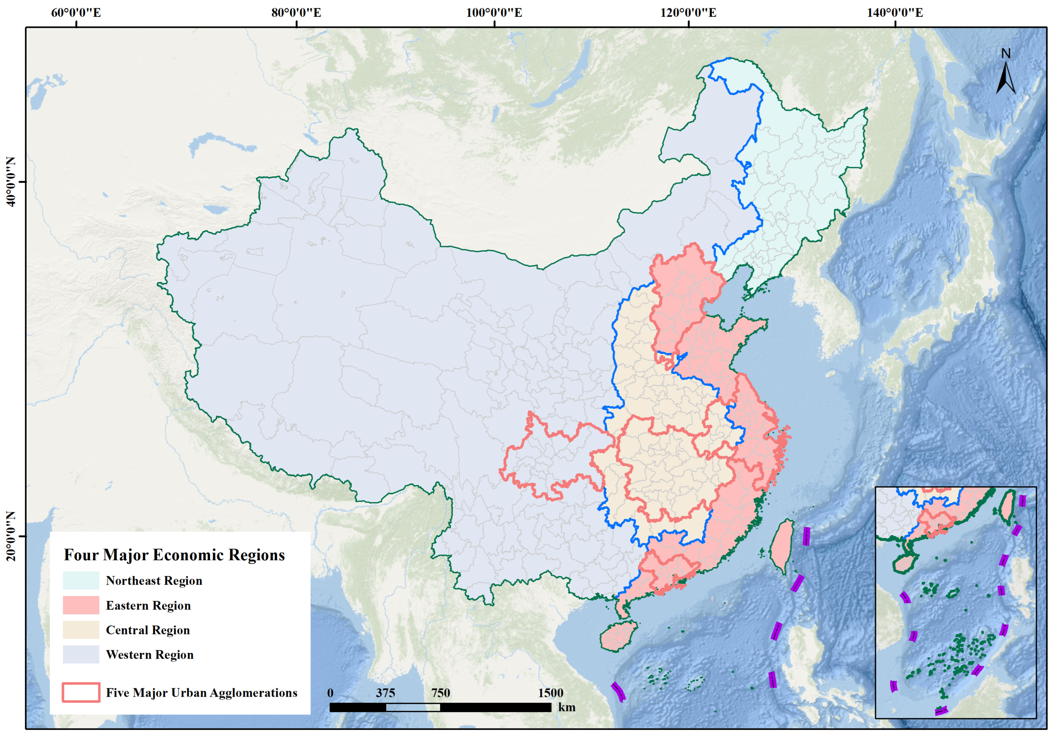
Based on the availability and completeness of data, this study selected 282 Chinese prefecture-level cities as the research sample, covering the period 2009–2021. All spatial calculations in this study adopted the CGCS2000 geodetic coordinate system and were projected using the Albers equal-area conic projection which is optimal for China’s territorial scope. This sample geographically spans China’s four officially categorized economic zones (Eastern, Central, Western, and Northeastern China) and includes five nationally pivotal urban agglomerations: Beijing–Tianjin–Hebei (BTH), Yangtze River Delta (YRD), Pearl River Delta (PRD), Middle Reaches of the Yangtze River (MRYR), and Chengdu–Chongqing (CC). These geographical units constitute core domains of China’s regional coordinated development strategy and are thus highly appropriate for exploring multi-scale green development disparities (Figure 1). To improve replicability, the specific constituent cities included in each of the five major urban agglomerations in this study are explicitly listed in Table 1.

2.2. Data Sources

The empirical dataset constructed for this study comprises vector-based administrative boundary data and a comprehensive suite of socioeconomic statistical indicators, the detailed sources of which are systematically summarized in Table 2. Primary statistical data were extracted from the China City Statistical Yearbook across the corresponding years. It should be noted that the 282 prefecture-level cities were selected based on the strict principles of data availability and continuity. Cities with severe missing data were excluded from the sample at the outset (represented by the ‘No data’ areas in the spatial maps). The retained dataset demonstrated high completeness, with the vast majority of observations directly obtained from official statistical yearbooks. Minor missing values, accounting for merely 2.78% of the total panel dataset, were systematically imputed or supplemented via provincial and municipal statistical yearbooks or imputed using linear interpolation (for intermediate gaps) and trend extrapolation (for endpoint missingness) to ensure a strictly balanced panel structure. Furthermore, robust data pre-processing was implemented to ensure spatiotemporal comparability.

2.3. Research Methods

2.3.1. Spatial Autocorrelation Analysis

  • Global Moran’s I
Global Moran’s I was first proposed by Moran [27] to quantify the overall spatial correlation and clustering intensity of variables across the study area. The formula is as follows:
I = n i = 1 n j = 1 n w i j x i x ¯ x j x ¯ i = 1 n j = 1 n w i j i = 1 n x i x ¯ 2
where I denotes the Global Moran’s I; n is the number of regions; w i j represents the spatial weight matrix; x i and x j are the green development levels of region i and region j , respectively. A row-standardized Queen contiguity spatial weight matrix was adopted in this study. Global Moran’s I range from −1 to 1. A positive value indicates positive spatial autocorrelation (clustered pattern); a negative value indicates negative autocorrelation (dispersed pattern); 0 indicates random distribution.
2.
Local Moran’s I
Local Moran’s I was a supplement to the global index, which identifies the specific spatial location and intensity of local clustering [28]. The formula is:
I i = n x i x ¯ j = 1 n w i j x j x ¯ i = 1 n x i x ¯ 2
where I i is Local Moran’s I for city i ; other variables are consistent with Equation (1).

2.3.2. Standard Deviational Ellipse (SDE)

Standard deviational ellipse analysis is widely used to measure the spatial dispersion of geographic elements. It calculates the standard distances along the x- and y-axes, combined with the center coordinates and azimuth angle, to characterize the spatial distribution pattern. The core formulas are as follows:
G x = i = 1 n w i x i i = 1 n w i
G y = i = 1 n w i y i i = 1 n w i
tan θ = i = 1 n w i x ~ i 2 i = 1 n w i y ~ i 2 + i = 1 n w i x ~ i 2 i = 1 n w i y ~ i 2 2 + 4 ( i = 1 n w i x ~ i y ~ i ) 2 2 i = 1 n w i x ~ i y ~ i
σ x = 2 i = 1 n w i ( x ~ i cos θ y ~ i sin θ ) 2 i = 1 n w i
σ y = 2 i = 1 n w i ( y ~ i cos θ + x ~ i sin θ ) 2 i = 1 n w i
where G x   a n d   G y are the x-axis and y-axis coordinates of the ellipse center, respectively; n is the number of elements; w i represents the weight; the green development level was used as the weight in this study; θ is the azimuth angle of the ellipse; x ~ i   a n d   y ~ i are the deviations from the mean center along the x-axis and y-axis, respectively; σ x   a n d   σ y are the lengths of the ellipse along the x-axis and y-axis, respectively.

2.3.3. Dagum Gini Coefficient and Decomposition

To rigorously quantify regional disparities, this study employs the Dagum Gini coefficient, an advanced methodological extension of the traditional Gini index [29]. A primary analytical advantage of this approach is its capacity to decompose the overall Gini coefficient into three distinct components: within-region disparity ( G w ), between-region disparity ( G b ), and hyper-variable density ( G t ), thereby effectively capturing the overlapping effects between sub-samples. The formula for the overall Gini coefficient is as follows:
G = j = 1 k h = 1 k i = 1 n j r = 1 n h Y j i Y h r 2 n 2 Y ¯
where G denotes the overall Gini coefficient; k is the number of regional divisions; Y j i is the green development level of city i in region j ; Y h r is the green development level of city r in region h ; n j   a n d   n h are the numbers of cities in region j and region h , respectively; k represents the number of regions; Y ¯ is the average green development level of all cities.
  • Within-region Disparity
G j j = 1 2 Y j ¯ i = 1 n j r = 1 n j Y j i Y j r n j 2
P j = n j n
S j = n j Y j ¯ n Y ¯
G w = j = 1 k G j j P j S j
where G j j denotes the Gini coefficient within region j ; P j is the ratio of the number of cities in region j to the total number of cities; n is the total number of regions; S j is the ratio of the green development level within region j to the total development level of all regions; Y j ¯ is the average green development level of region j ; G w denotes the within-region disparity, reflecting the gap in green development levels among cities within a region.
2.
Between-region Disparity
G j h = i = 1 n j r = 1 n h Y j i Y h r n j n h ( Y j ¯ + Y h ¯ )
M j h = 0 d F j Y 0 Y Y x d F h x
N j h = 0 d F h Y 0 Y Y x d F j x
D j h = M j h N j h M j h + N j h
G n b = j = 2 k h = 1 j 1 G j h D j h P j S h + P h S j
where G j h denotes the Gini coefficient between region j and region h ; Y h ¯ is the average green development level of region h ; M j h is the mathematical expectation of the sum of sample values; N j h is the first-order hyper-variable moment, representing the mathematical expectation of the sum of sample values where Y h r Y j i > 0 ; F h and F j are the cumulative density distribution functions of region j and region h , respectively; D j h denotes the relative influence of green development levels between region j and region h ; G n b denotes the between-region disparity, reflecting the gap in green development levels between different regions.
3.
Hyper-variable Density
G t = j = 2 k h = 1 j 1 G j h P j S h + P h S j 1 D j h
where G t denotes the hyper-variable density, representing the interaction between within-region and between-region disparities.

2.4. Indicator System for Green Development Level

Constructing a comprehensive and innovative analytical framework is crucial for systematically exploring the complex mechanisms underlying urban green development. Some existing research has built an original measurement framework to interpret the evolutionary characteristics of urban systems, which can provide reference ideas for the construction of urban green development evaluation frameworks for this study [30]. Following the principles of systematicity, scientific rigor, and feasibility, and based on sustainability theory and China’s urban development reality [26], this study constructed a three-dimensional evaluation system for green development level (Green Economy Development–Green Ecological Protection–Green Social Progress) in strict alignment with the core requirements of SDG 8 (Decent Work and Economic Growth), SDG 11 (Sustainable Cities and Communities), and SDG 15 (Life on Land). To establish a rigorous evaluation benchmark, each selected variable has been systematically mapped to its corresponding official UN SDG sub-targets, as detailed in Table 3. It should be noted that the UN SDGs are broad, macro-level global goals. Given the data availability at the prefecture-city level, the selected indicators act as practical regional proxies. While they may not encompass the entire macro scope of the UN targets, they maintain a fundamental relevance to the core objectives of SDG 8, SDG 11, and SDG 15, effectively reflecting the actual green development orientations of local cities. In terms of theoretical justification, urban ecological governance constitutes a holistic urban–rural terrestrial ecosystem governance issue. All indicators under the Green Ecological Protection dimension satisfy the livable urban construction demands of SDG 11, and also well echo the core connotation of SDG 15 for terrestrial ecological conservation: restraining urban industrial pollution can effectively mitigate cross-regional land degradation, whereas the expansion of urban green spaces helps relieve the fragmentation of urban and rural terrestrial habitats. Furthermore, while SDGs 8, 11, and 15 constitute the primary macro-framework of this study, comprehensive green development cannot be achieved without addressing fundamental human capital and public health. Therefore, within the Green Social Progress dimension, education and healthcare metrics are systematically incorporated as indispensable supplementary targets. Specifically, education-related indicators are directly mapped to SDG 4.3, while health-oriented metrics are explicitly aligned with SDG 3.8. This rigorous sub-target mapping ensures that the inclusiveness and resilience of public services are accurately captured.
Green Economy Development focuses on high-quality economic transition and green growth drivers, covering industrial transformation and upgrading, inclusive economic growth, and green technological innovation. The overall upgrading and rationalization of industrial structure were adopted to reflect the green optimization of urban industrial structure [31,32]. Per capita GDP, urban–rural income Gini coefficient, and per capita disposable income were included to balance growth scale and equity, consistent with the inclusive green growth concept of the OECD [33,34]. R&D personnel, R&D expenditure ratio, and granted green patents were used to measure green innovation input and output [35]. Green Ecological Protection aims to improve ecological quality and sustainable carrying capacity, including ecological habitat construction and production environmental protection. Per capita park green area, built-up area green coverage rate, and domestic waste harmless treatment rate were selected to reflect urban ecological livability [21]. Industrial SO2, smoke, and wastewater emissions were utilized to characterize industrial pollution control intensity [34]. Green Social Progress focuses on public welfare and green lifestyle popularization, covering green consumption, green travel, talent development, and social health. Energy intensity and per capita household electricity consumption measured green consumption. Per capita road area, public buses per 10,000 people, and passenger traffic per 10,000 people reflected green transport capacity. College students per 10,000 people and science and education expenditure indicated human capital accumulation [25,36]. Urban basic medical insurance participants and doctors per 10,000 people represented public service security [37].
Indicator weights were calculated via the CRITIC weighting method proposed by Diakoulaki et al. [38]. Existing weighting tools fall into two categories: subjective methods based on expert experience, including analytic hierarchy process, Delphi method and comparative ranking methods; and data-driven objective methods covering principal component analysis, entropy weight method and CRITIC method. Entropy weighting relies on data dispersion to calculate weights but ignores inter-indicator correlation; principal component analysis eliminates redundant information via dimensionality reduction yet may lose unique single-indicator features and performs poorly for nonlinear data. In contrast, the CRITIC method simultaneously considers data variability and cross-indicator correlation conflicts, quantifies criterion conflicts to achieve objective weight allocation, and delivers more balanced multi-index weight distribution compared with traditional subjective weighting approaches [39]. The CRITIC calculation steps are briefly summarized as follows. All indicators were first standardized through range normalization to eliminate dimensional differences and align their evaluation directions. The specific standardization formulas are as follows:
For positive indicators:
X i j = X i j X m i n X m a x X m i n
For negative indicators:
X i j = X m a x X i j X m a x X m i n
where X i j represents the standardized value, X i j is the original data.
Negative indicators were reverse-scaled to ensure that higher normalized values consistently represent superior green development performance across all metrics. To ensure strict spatiotemporal comparability across the study period, this normalization was conducted globally over the entire city-year panel. Subsequently, we compute each indicator’s variability and conflict. Variability is represented by the standard deviation ( S j ):
S j = i = 1 m X i j X j ¯ 2 m 1
where X j ¯ is the mean value of the standardized indicator j , and m is the total number of evaluation objects (cities, m = 3666). The conflict ( R j ) between indicators is measured using the Pearson correlation coefficient ( r k j ):
R j = k = 1 p 1 r k j
where r k j represents the correlation coefficient of indicator k and indicator j , p represents the total number of evaluation indicators. Each indicator’s total information volume C j is then obtained by multiplying the variability and conflict values:
C j = S j × R j
The final objective weight w j for each indicator is calculated by normalizing the information volume:
w j = C j k = 1 p C k
Consistency tests on indicator discrimination were conducted before weight output, confirming sufficient differentiation capacity and no severe information redundancy. All indicator weights are listed in the Weight column of Table 3. Finally, the composite green development score ( G D S i ) of each city is acquired by the linear weighted summation of the standardized indicators:
G D S i = j = 1 p w j × X i j
The spatial autocorrelation and weighted standard deviational ellipse analyses were conducted using ArcGIS 10.8 software (Esri, Redlands, CA, USA). Specifically, a Queen contiguity spatial weight matrix was employed to construct the spatial relationships for Moran’s I calculations. For the spatial dispersion analysis, the 1-standard deviational ellipse parameter was adopted to cover approximately 68% of the weighted spatial features. The mathematical computations for the Dagum Gini coefficient decomposition and the CRITIC objective weighting procedure were mathematically implemented using MATLAB R2021a (MathWorks, Natick, MA, USA).

3. Results

3.1. Spatiotemporal Evolution Characteristics of Green Development Level

3.1.1. Green Economic Development Level

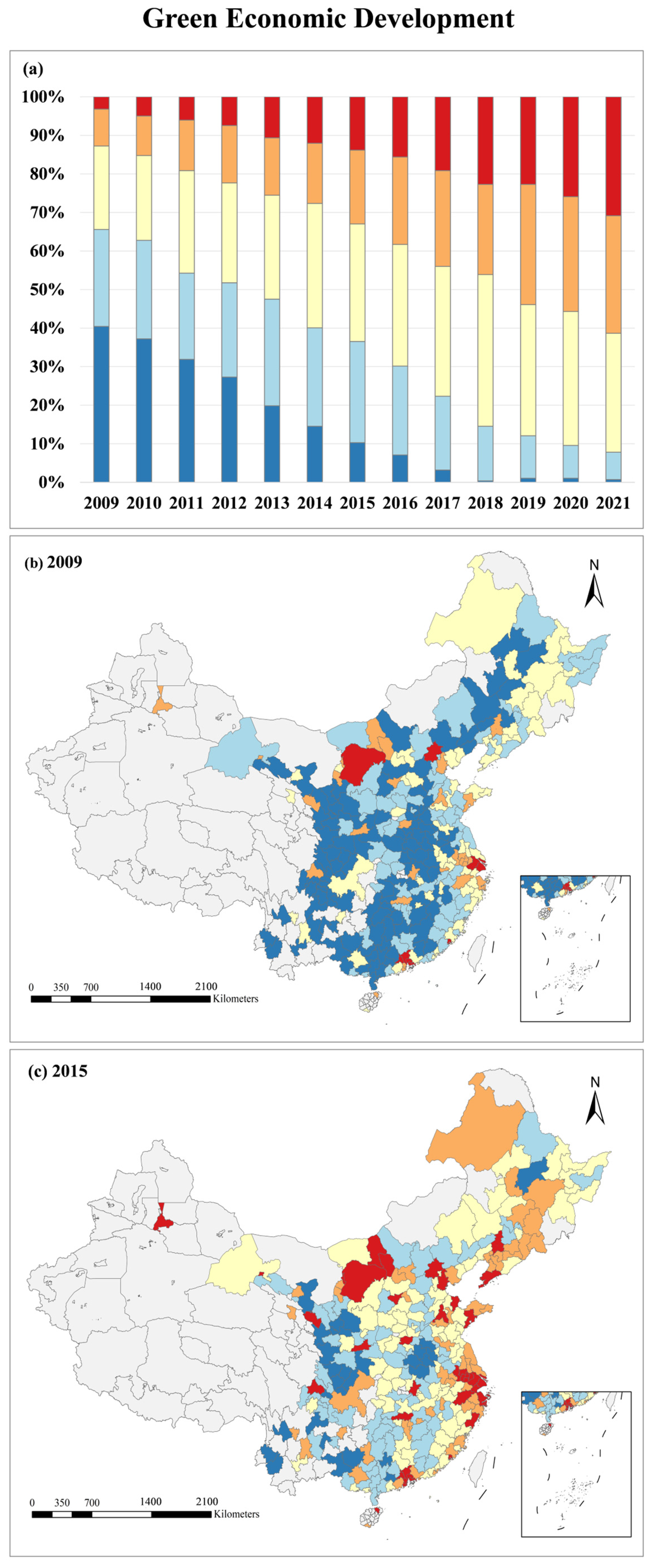
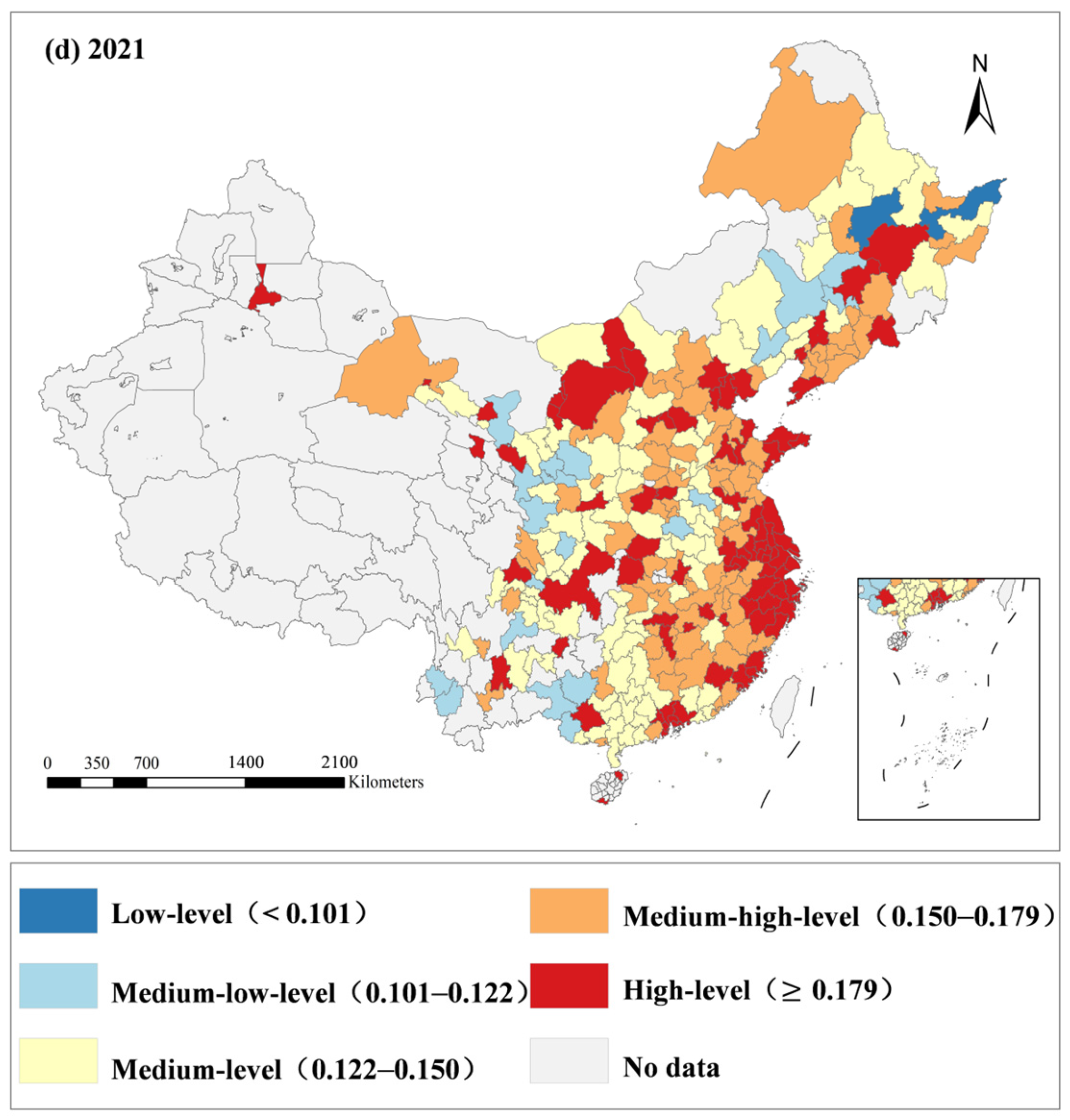
As a subsystem of overall green development, green economy development serves as a crucial component in the implementation of SDG 8. It directly reflects the spatiotemporal dynamics of urban industrial green transformation, inclusive growth, and green innovation capacity. Based on the evaluation system established via the CRITIC weighting method, this study classified the green economy development level into five grades using the quantile thresholds of 15%, 20%, 30%, 20%, and 15%, corresponding to Low-level, Medium-low-level, Medium-level, Medium-high-level, and High-level, respectively. From 2009 to 2021, the green economy development level of Chinese cities showed a steady upward trend, and the share of High-level cities increased rapidly, a trend that closely aligns with the progress of SDG 8.1, SDG 8.2, and SDG 8.4 (Figure 2). In 2009, only nine cities reached the High-level (3.19%, score > 0.179), mostly provincial capitals and core nodes of developed urban agglomerations such as Beijing, Shanghai, Guangzhou, Shenzhen, Xiamen, and Hohhot. Meanwhile, 185 cities (65.61%) scored below 0.122, categorizing them at Low- or Medium-low-levels. These were predominantly resource-dependent and agricultural cities in Central and Western China, indicating a highly polarized spatial distribution characterized by a limited number of leading hubs and a vast majority of lagging regions.
In 2015, Medium-level cities became dominant (30.50%), and 39 High-level cities (13.83%) were concentrated in eastern coastal urban agglomerations and provincial capitals in central and western China. However, heavy industry-based cities such as Dezhou, Linyi, Jiaozuo, and Fuyang remained at relatively low levels, which may be potentially associated with their delayed green transition and constrained innovation capacities. By 2021, 87 cities (30.85%) reached the High-level and 86 cities (30.59%) reached the Medium-high-level, together accounting for over 60%, indicating a structural transition toward cluster-driven synergistic development. The share of Low-level and Medium-low-level cities shrank to 7.8%. Some northern cities such as Jiamusi, Suihua, and Songyuan experienced slow improvement, reflecting a structural inertia that contextually corresponds with their homogenous industrial bases and constrained talent inflows.

3.1.2. Green Ecological Protection Level

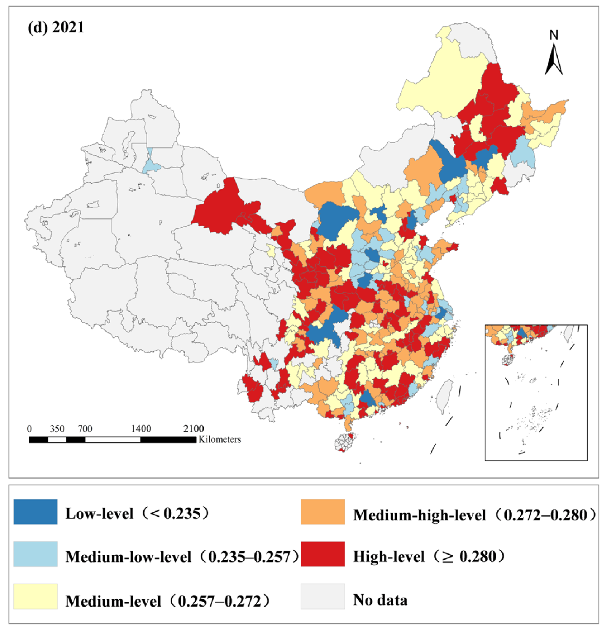
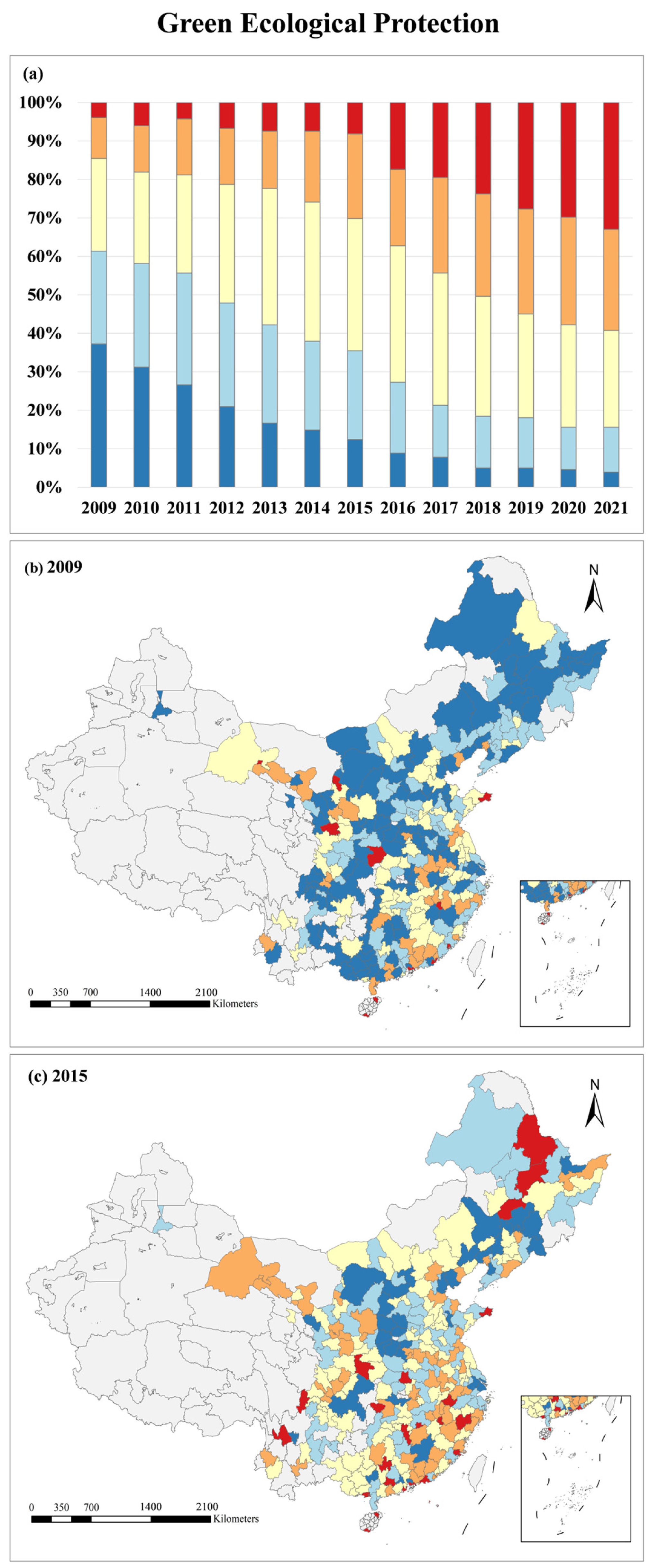
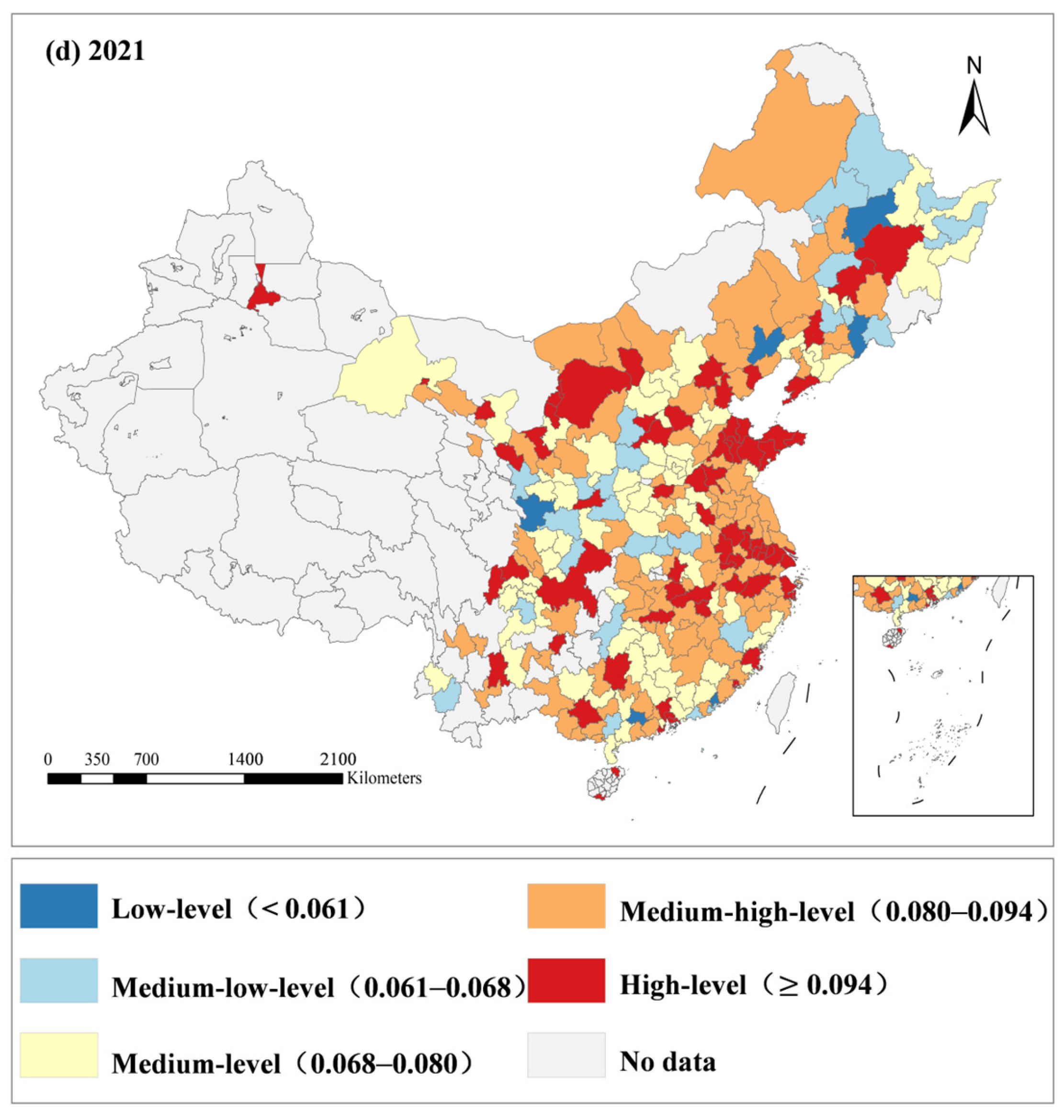
Green Ecological Protection Level directly reflects the core requirements of SDG 11 (Sustainable Cities and Communities) and SDG 15 (Life on Land), which focus on urban habitat optimization and industrial pollution abatement across the research period. From 2009 to 2021, China’s Green Ecological Protection Level increased steadily (Figure 3). In 2009, merely 11 cities (3.90%) reached High-level status, which were scattered among coastal special economic cities including Shenzhen and Xiamen, tourist-oriented cities such as Sanya and Haikou, and inland cities with superior natural ecological endowments like Yingtan, Shiyan and Jiayuguan. By contrast, a total of 105 cities (37.23%) fell into the Low-level category with scores below 0.235, and another 68 cities (24.11%) belonged to the Medium-low-level group. Even economically advanced eastern cities such as Beijing, Shanghai, Guangzhou and Hangzhou recorded a relatively lagging Green Ecological Protection Level compared with their Green Economic Development Level, and which indicated a challenge in achieving coordinated advancement between economic expansion and ecological conservation in this period.
In 2015, the Green Ecological Protection Level showed noticeable improvement, and Medium-level cities became the dominant group with 97 samples, accounting for 34.40%. A total of 35 cities remained at the Low-level below the threshold of 0.235 (12.41%), while only 23 cities exceeded 0.280 and attained the High-level tier (8.16%). Several Eastern China cities including Jinhua, Beijing and Taizhou made evident progress in ecological governance, yet intra-regional disparities persisted across the eastern region. By 2021, the comprehensive achievements of China’s ecological civilization construction were accompanied by a more balanced spatial development of the Green Ecological Protection Level, forming an emerging multi-centric spatial network. Specifically, 93 cities surpassed the critical value of 0.280 and were classified as High-level (32.98%), 71 cities fell into the Medium-level category (25.18%), and another 74 cities belonged to the Medium-high-level group (26.24%). Ecological protection increasingly emerged as a fundamental prerequisite for high-quality urban development across the nation. As Figure 3 presents, Eastern China achieved continuous ecological progress. The consistent improvements observed in Shanghai, Hangzhou, Shaoxing, and Ningbo exhibit a strong temporal alignment with the implementation of the integrated eco-green development policy in the Yangtze River Delta (YRD).

3.1.3. Green Social Progress Level

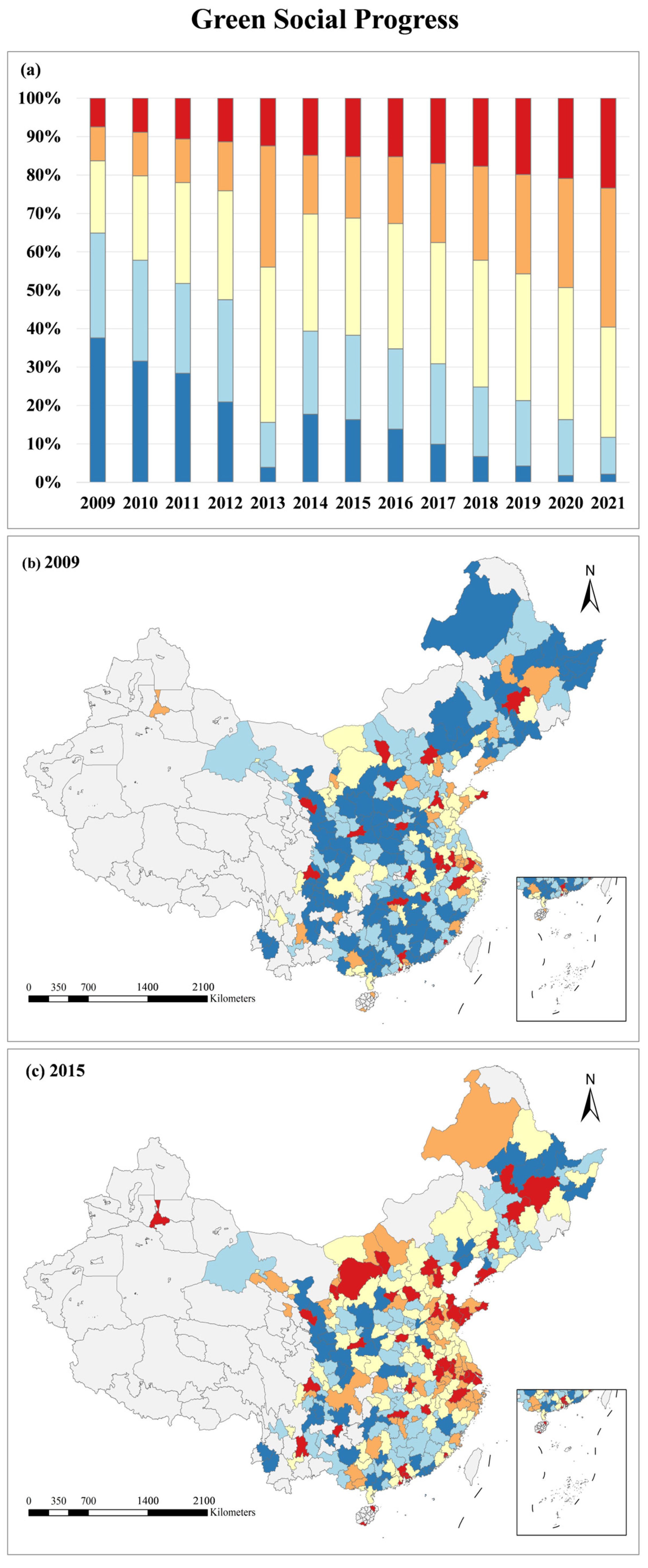
The Green Social Progress Level targets the green living and public service goals of SDG 11, measuring the coordination between regional social development, ecological conservation and high-quality economic growth through upgraded green consumption, optimized public services and improved social security. The nationwide Green Social Progress Level increased steadily from 2009 to 2021 but stayed at an overall low level (Figure 4). In 2009, 21 cities were classified as High-level, accounting for 7.45%. Concentrated sporadically in provincial capitals and core agglomeration nodes including Beijing, Hangzhou and Chengdu, these cities exhibited strong performance in green transportation, talent accumulation and social welfare, which is spatially associated with their dense population distributions, sufficient fiscal allocations, and mature infrastructural frameworks. A total of 106 cities scored below 0.061 and fell into the Low-level category, accounting for 37.59%. Spatially, high-value areas clustered in Eastern China, while Northeastern, Central and Western China recorded poorer development.
In 2015, Medium-level cities dominated the sample at 30.50% (86 cities). Low-level cities below 0.061 decreased to 46 (16.31%), and 43 cities exceeded 0.094 to reach the High-level tier (15.25%). Continuous improvements occurred in the YRD and PRD, forming contiguous high-value zones. In 2021, the Medium-high-level category became the leading grade. A total of 102 cities ranging from 0.080 to 0.094 belonged to Medium-high-level (36.17%), and 66 cities above 0.094 were High-level (23.40%). Medium-high and High-level cities mainly clustered in Eastern China. The rapid development of new energy industries likely facilitated the regional green energy transition, further supported by comprehensive public transportation networks and mature social security systems in this region.

3.1.4. Spatial Distribution Characteristics of Comprehensive Green Development Level

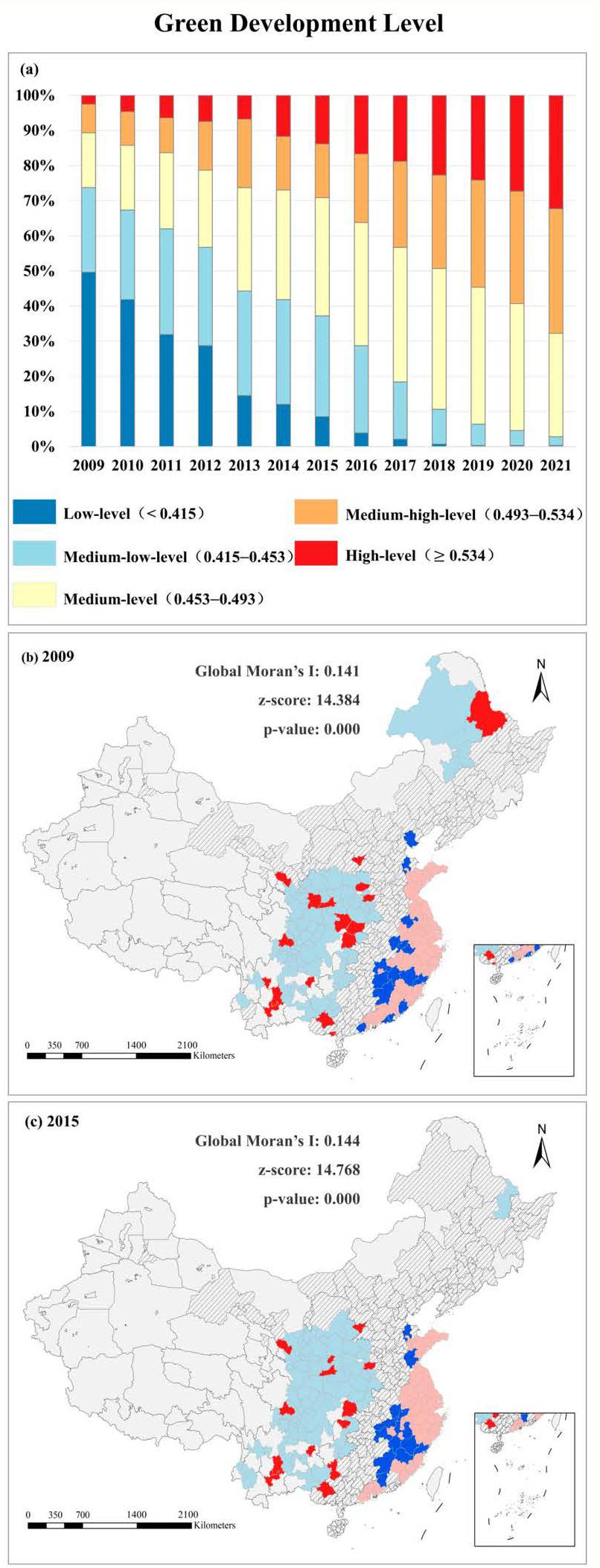
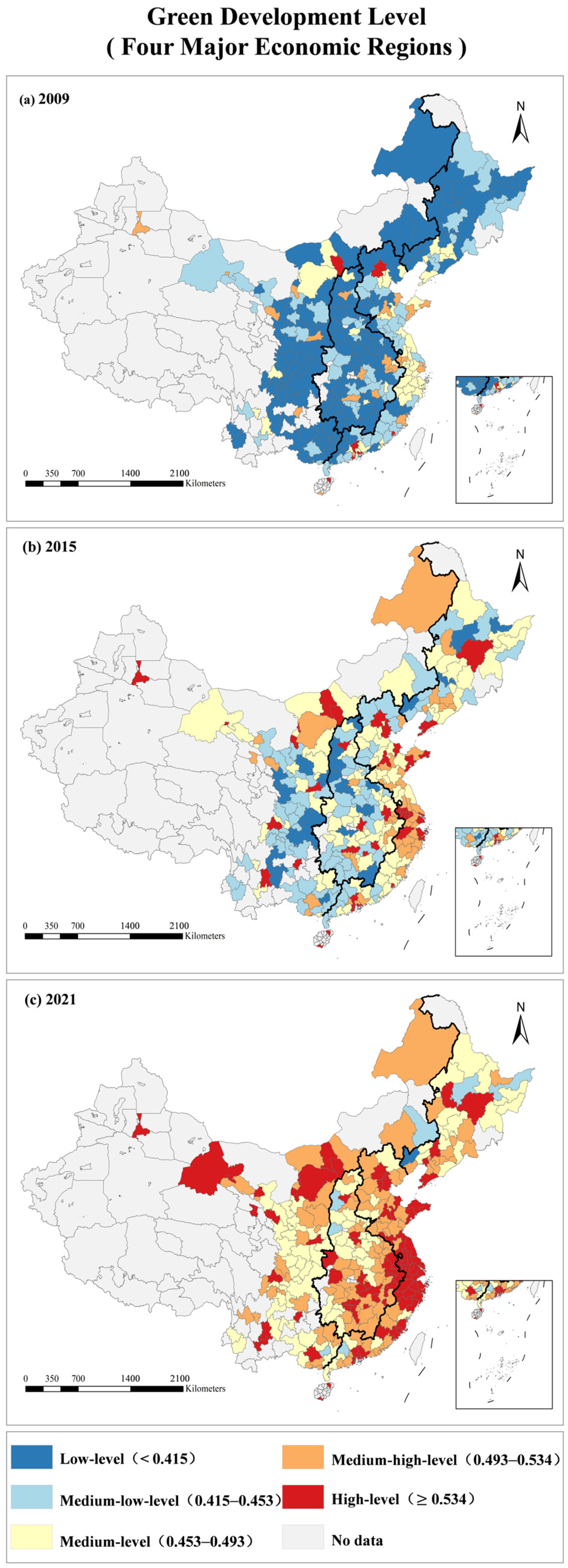
The comprehensive green development level captures the coordinated advancement of SDG 8, SDG 11 and SDG 15. From 2009 to 2021, the national urban comprehensive green development level showed a general upward trend, accompanied by narrowed regional gaps and an overall southwestward shift of the spatial gravity center (Figure 5). In 2009, 140 cities scored below 0.415 and were classified as Low-level, accounting for 49.65%, while merely seven cities above 0.534 reached the High-level tier (2.48%). Cities at the Medium-level or above were primarily concentrated in Eastern China and provincial capitals across Central and Western China. In 2015, 39 cities attained High-level status (13.83%), and only 24 cities remained in the Low-level category below 0.415 (8.51%). Most cities clustered at the Medium-level, ranging from 0.453 to 0.493, which accounted for 33.69%. By 2021, 91 cities exceeded 0.534 and reached the High-level tier (32.27%), and 100 cities with values between 0.493 and 0.534 belonged to the Medium-high-level group (35.46%). Only one city remained in the Low-level category (0.35%). The number of High-level cities increased 12-fold during the research period, whereas Low-level cities decreased by 99.29%.
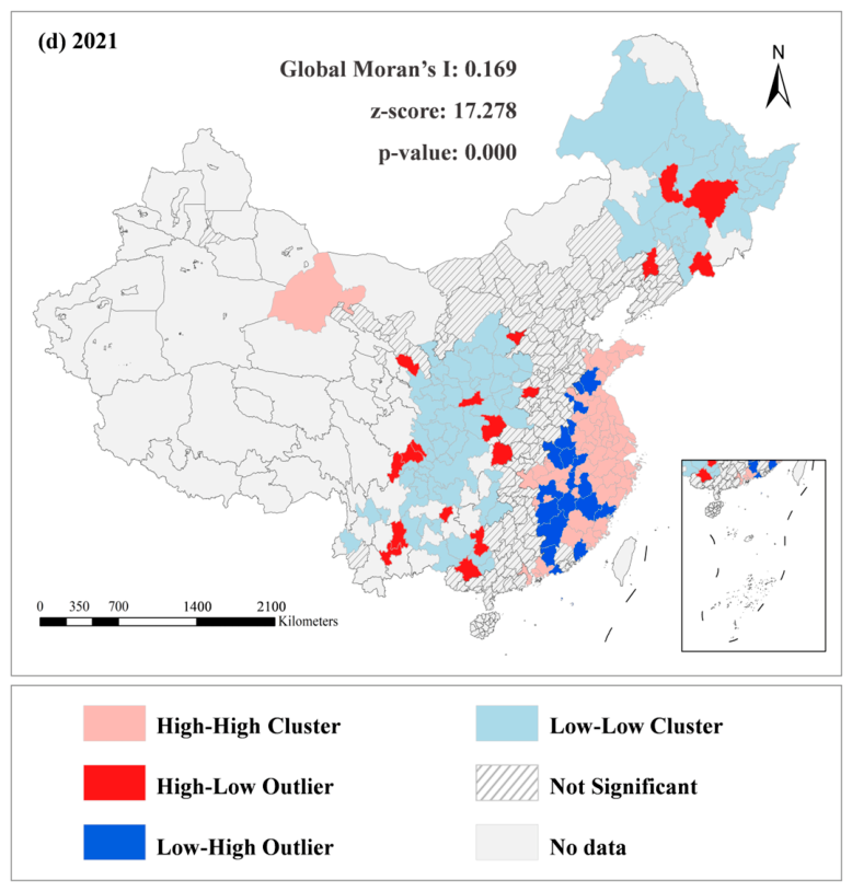
Global and Local Moran’s I analyses were adopted to identify spatial agglomeration patterns. The values of Global Moran’s I for 2009, 2015, and 2021 were 0.141, 0.144, and 0.169, respectively, with all corresponding p-values less than 0.01. This demonstrated highly significant spatial clustering of green development levels among cities; therefore, the Local Moran’s I analysis was subsequently conducted. As Figure 5 shows, High-High clusters were predominantly distributed in developed Eastern coastal regions including the YRD and PRD urban agglomerations. Low-High agglomerations appeared in mountainous peripheral cities of Eastern China such as Nanping and Anqing. High-Low and Low-Low clusters were primarily concentrated in Central, Western and Northeastern China. Low-Low clusters frequently surrounded Low-High zones, indicating entrenched spatial dependence and localized stagnation, rather than active spatial integration with adjacent high-performing nodes. From 2009 to 2021, High-High clustering strengthened continuously in Eastern coastal urban agglomerations; High-Low and Low-High distributions improved in central and western areas, yet Low-Low agglomerations persisted in less-developed regions.
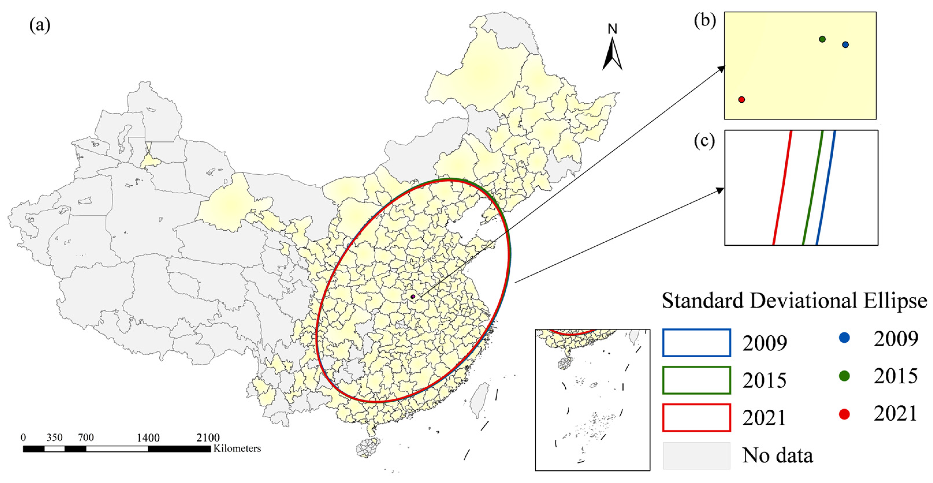
The Standard Deviational Ellipse (SDE) method was further used to characterize the spatial evolution (Figure 6 and Table 4). This approach comprehensively captures the evolutionary characteristics of geographical elements from multiple dimensions, including central position, directional trend and spatial morphology [40]. The rotation angle of the ellipse changed moderately from 47.61° in 2009 to 47.74° in 2021, suggesting ongoing adjustments in the spatial distribution of green development levels. In 2009, the major axis followed a northeast–southwest direction with prominent east–west gaps; high-value areas concentrated in the YRD and PRD while most western cities remained below the national average. In 2015, the x-axis standard distance expanded to 11.28 and the y-axis shortened to 7.50, indicating a widening east–west disparity, and the spatial gravity center migrated roughly 1.89 km toward the northwest. In 2021, the x-axis standard distance decreased to 11.18 and the y-axis fell to 7.48, corresponding to narrowed east–west disparities. The Chengdu–Chongqing (CC), Guanzhong Plain and Middle Reaches of the Yangtze River (MRYR) urban agglomerations gradually evolved into new growth poles, and provincial capital cities in Central and Western China achieved general score upgrades. North–south gaps weakened; southern cities maintained higher green development levels, and old northern industrial cities including Shenyang and Changchun experienced gradual improvements in their scores. The gravity center shifted approximately 10.08 km toward the southwest between 2009 and 2021. Overall, the national gravity center moved persistently westward across the study period. From a national macro perspective, the total 10.08 km shift of the gravity center indicates a mild spatial adjustment of green development across the five urban agglomerations. Such a small migration range suggests that the overall spatial pattern of urban green development remained relatively stable during the research period without dramatic structural shifts in regional disparities, while the migration direction reflects the differentiated green development progress between coastal and inland city clusters. Based on the standard distance metrics, the spatial dispersion in the north–south direction remained relatively stable, while the east–west direction exhibited a broader spatial distribution. The changing x-axis standard distance reflected a dynamic adjustment of green development’s spatial coverage across the country, characterized by an initial spatial expansion and a subsequent slight spatial contraction.

3.2. Spatiotemporal Evolution of Green Development Level Across Four Major Economic Zones

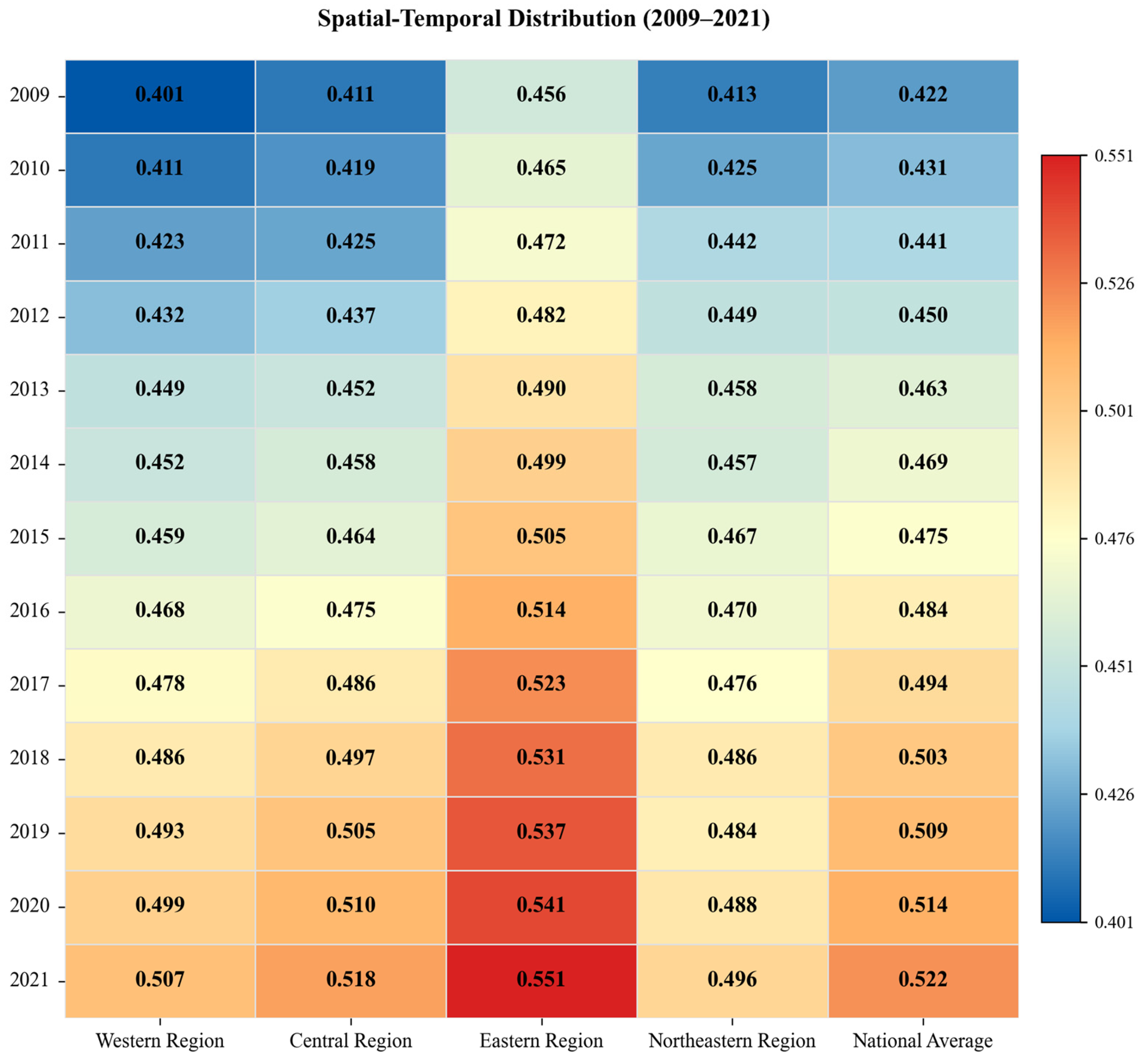
Distinct disparities in resource endowment, industrial structure and policy support are closely associated with the differentiated green development paths among Eastern, Central, Western and Northeastern China, the core spatial units of China’s regional coordinated development strategy. This section quantitatively explores regional evolutionary patterns via annual statistics, spatial patterns and the Dagum Gini coefficient decomposition. As shown in Figure 7, the green development level of all four zones rose steadily from 2009 to 2021, following a consistent hierarchical pattern, Eastern China > Central China > Western China > Northeastern China, with diverging absolute values and growth rates. Throughout the study period, Eastern China consistently maintained a developmental lead over the National Average. Its green development index climbed from 0.456 in 2009 to 0.551 in 2021, with a cumulative growth of 20.83%. The index of Central China increased from 0.411 to 0.518 (26.03%), approaching the National Average in 2021 and demonstrating a clear catch-up trend. Western China registered the lowest initial value of 0.401 in 2009 yet achieved the fastest overall growth at 26.43%, with its index reaching 0.507 by 2021. By contrast, Northeastern China lagged behind throughout the study period; its index grew mildly from 0.413 (2009) to 0.496 (2021) at a cumulative growth of merely 20.10%, which was 6.33 and 3.60 percentage points lower than Western China and the National Average, respectively, suggesting the presence of persistent obstacles restricting its green transformation. Distinct phased growth trends were observed across regions. Eastern China’s annual growth slowed to 1.30% during 2019–2021, down from 1.79% in 2009–2015, potentially indicative of diminishing marginal gains from traditional green development drivers (Note: Annual growth in this study is calculated as the Simple Average Annual Growth Rate: [(ValueendValuestart)/Valuestart] × 100%/n, where n is the number of years.). The accelerated growth trajectories observed in Central and Western China post-2015 temporally coincide with the implementation phase of the Rise of Central China Plan and the Western Development Strategy. During the 2015–2021 period, they achieved respective annual growth rates of 1.94% and 1.74%, exceeding the contemporaneous rate of Eastern China. Northeastern China maintained low and stable annual growth of 1.03% after 2015, accompanied by a slight index decline from 0.486 to 0.484 during 2018–2019, a stagnation potentially constrained by its rigid industrial structure and continuous factor outflows.
Spatially, the regional spatial pattern evolved toward a clustered high-value concentration in Eastern China, a core-city-driven development model in inland Central and Western China, and a scattered low-value distribution across Northeastern China (Figure 8). High-value areas in Eastern China expanded from sporadic core cities such as Beijing, Shanghai and Shenzhen into contiguous belts covering Shanghai, Hangzhou and Suzhou. Central and Western China’s high-level areas centered on provincial capitals and experienced gradual peripheral spillovers, a trend that may be linked to industrial relocation and watershed ecological governance projects. In Northeastern China, high-performing cities were limited to Shenyang and Dalian, while most resource-dependent prefectures remained at relatively low tiers.
To identify the sources of inter-regional gaps in green development across the four economic zones, this study adopted the Dagum Gini coefficient and its decomposition method to quantify disparity composition from 2009 to 2021 (Table 5). The overall national Gini coefficient declined from 0.072 in 2009 to 0.053 in 2021, a decrease of 26.39%, indicating a continuous convergence in regional gaps nationwide. The decomposition results classified the total disparities into within-region disparity (Gw), between-region disparity (Gb) and hyper-variable density (Gt), with differentiated contribution proportions. In 2021, between-region disparity became the dominant source of overall gaps with a contribution rate of 38.84%, up slightly by 0.98 percentage points compared with 2009; hyper-variable density ranked second at 35.84%, falling by 1.47 percentage points; the contribution of within-region disparity remained around 25%, and the Gw value decreased from 0.018 to 0.014, suggesting an improved internal equilibrium within each economic zone.
From the intra-regional disparity perspective, Eastern China exhibited the largest internal gap with a 2021 Gini coefficient of 0.057 and the smallest decline of 8.06%, a phenomenon likely associated with persistent development gaps between mature core metropolitan areas and underdeveloped peripheral regions. Western China’s internal Gini dropped sharply from 0.072 to 0.046 (a reduction of 36.11%), potentially benefiting from targeted ecological protection and green industrial support under the Western Development Strategy. Northeastern China maintained a relatively low intra-regional Gini of 0.043 in 2021, yet such internal equalization did not translate into an improvement in its overall national development ranking. The high contribution of hyper-variable density highlights prominent interactive gaps between high-index eastern coastal cities and low-index resource-based cities in Western and Northeastern China, and the mild drop in its contribution may suggest a positive role of cross-regional coordinated policies on narrowing extreme developmental differentiation.

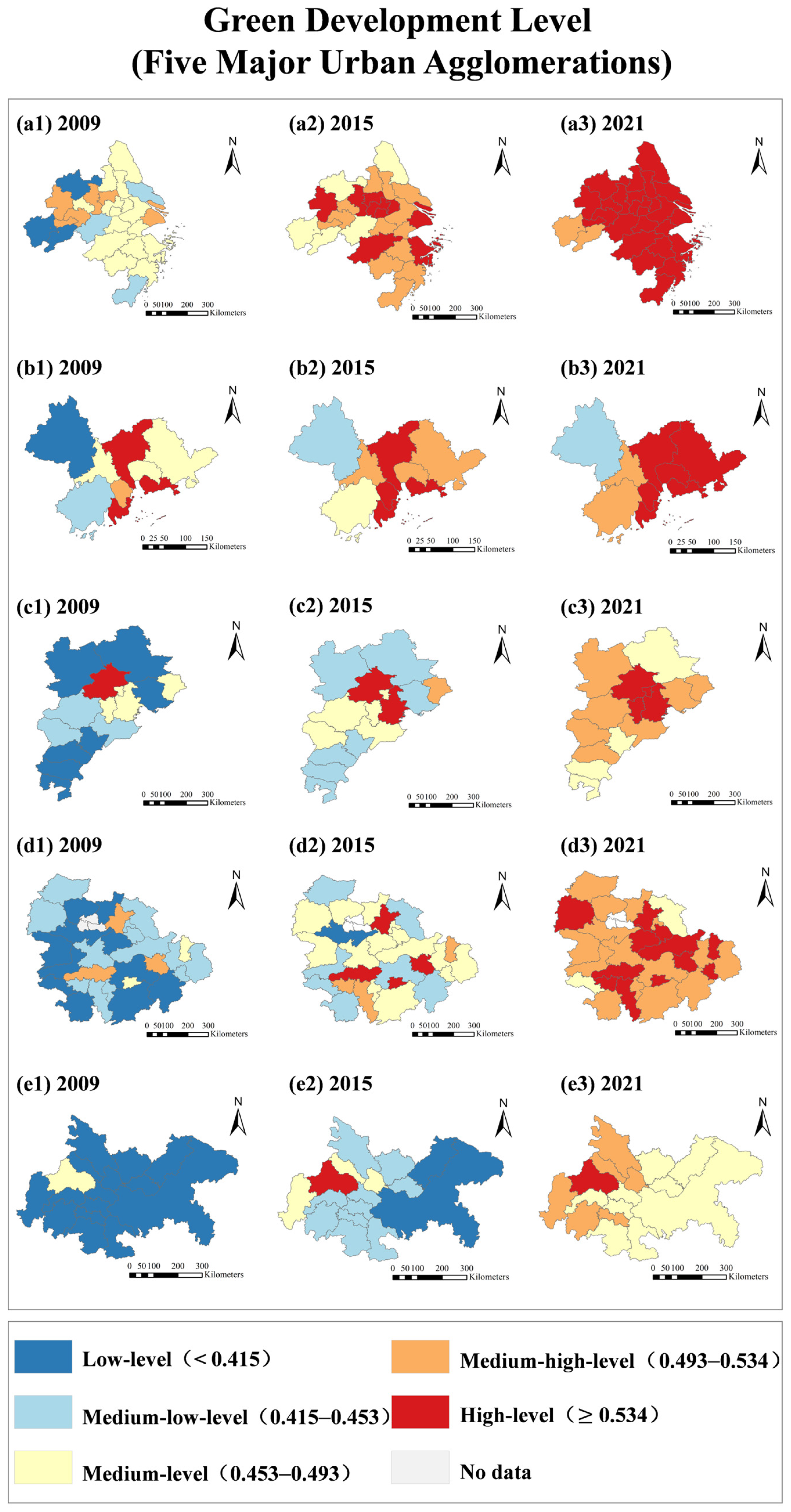
3.3. Spatiotemporal Evolution of Green Development Level at Urban Agglomeration Scale

As core spatial units of China’s coordinated regional development strategy, urban agglomerations are widely regarded as crucial spatial units for national green transition, characterized by factor agglomeration, industrial linkage and coordinated policy implementation. This study selected five mature urban agglomerations, namely Beijing–Tianjin–Hebei (BTH), Yangtze River Delta (YRD), Pearl River Delta (PRD), Middle Reaches of the Yangtze River (MRYR), and Chengdu–Chongqing (CC), to quantitatively explore the evolutionary patterns and disparity sources of green development from 2009 to 2021 through annual statistics, spatial pattern identification and the Dagum Gini coefficient decomposition.
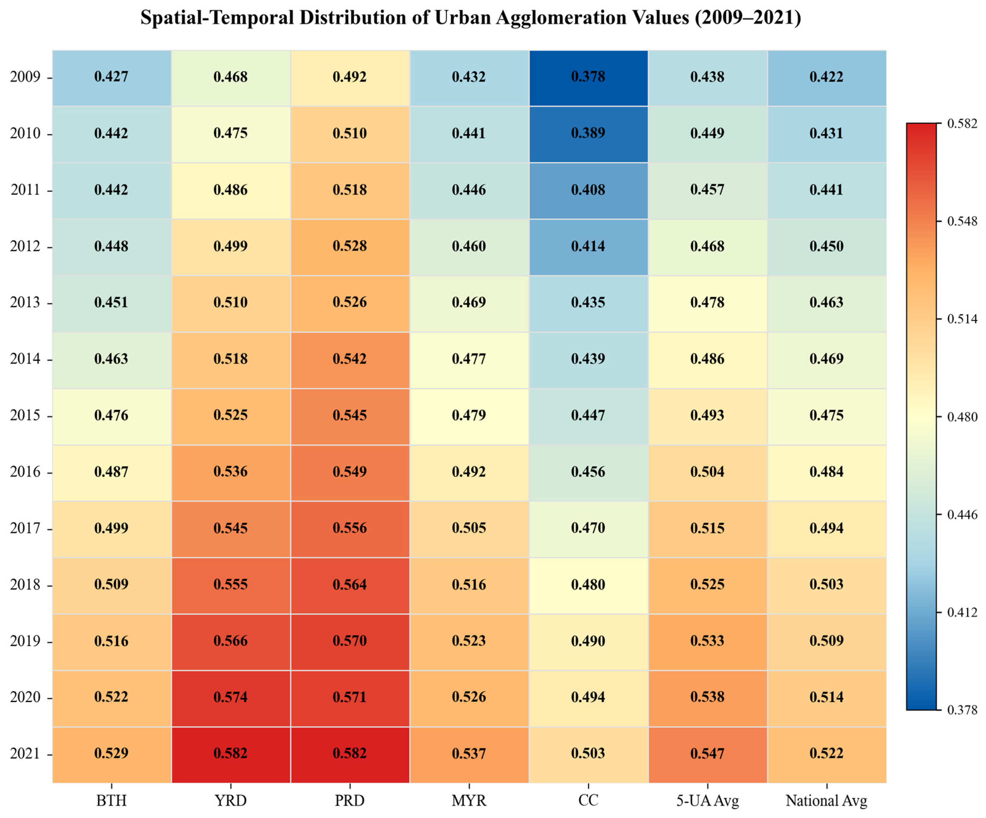
All five urban agglomerations achieved continuous improvement in green development during the research period. While most agglomerations outpaced the national average, the PRD registered a comparatively lower cumulative growth rate, largely due to its high initial development baseline. However, evident gaps existed in absolute development levels and growth rates, forming a stable hierarchical pattern: the YRD and PRD took the leading position, the MRYR and BTH ranked in the middle, and the CC remained in the catch-up stage (Figure 9). In 2021, the average green development index was 0.582 for both the YRD and PRD, followed by the MRYR (0.537), BTH (0.529) and CC (0.503). The YRD and PRD were 11.5% higher than the National Average of 0.522; starting from the lowest initial value of 0.378 in 2009, the CC gradually approached the national benchmark by 2021. In terms of cumulative growth rates, the CC registered the fastest increase at 33.07%, rising from 0.378 in 2009 to 0.503 in 2021 with an annual growth of 2.76%. The YRD and MRYR increased by 24.36% and 24.31% respectively, while the BTH (23.89%) and PRD (18.29%) recorded relatively slower growth, with the PRD presenting the lowest growth among all five clusters. All agglomerations exhibited a consistent temporal trajectory: rapid baseline growth prior to 2015, followed by increasingly differentiated developmental paths. Likely benefiting from policy dividends of the Yangtze River Economic Belt initiative, the CC and MRYR grew at annual rates of 3.04% and 1.81% from 2009 to 2015. After 2015, the YRD and BTH maintained steady annual growth of roughly 1.8%, whereas the PRD’s growth slowed to 1.13% as its green development likely entered a mature stage with diminishing marginal returns. Except for the CC, whose average level was below the national benchmark in the early stage, the remaining four agglomerations consistently exceeded the National Average. The narrowing gap between the CC and YRD may indicate a positive role of national agglomeration development policies in restraining overall regional divergence.
From 2009 to 2021, the core–periphery spatial structure of green development within all five agglomerations was gradually optimized, characterized by expanding high-value zones and shrinking low-value areas, though heterogeneous spatial evolution existed across regions, a divergence that may stem from disparities in industrial foundations and collaborative mechanisms (Figure 10). Benefiting from its strong foundation in industrial restructuring and technological innovation, the YRD displayed the most balanced spatial layout across the five clusters. In 2009, only a few core cities such as Shanghai, Nanjing and Hefei reached the Medium-high-level tier, exhibiting a scattered distribution. The High-level scope expanded to include Hangzhou, Ningbo, and Changzhou by 2015, with nearly all cities attaining High-level status by 2021, barring Anqing and Chizhou. This spatial evolution signifies a structural transition toward comprehensive coordinated development, characterized by a core-driven spillover pattern where peripheral areas progressively align with leading hubs. The gradual eastward expansion of high-value areas in the PRD structurally coincides with the region’s historical opening-up processes and early green planning initiatives. Its High-level cities were limited to Guangzhou, Shenzhen and Zhuhai in 2009, and most central and eastern cities achieved High-level by 2021 alongside persistent east–west internal gaps. Accounting for 2.3% of China’s land area and 7.23% of its population, the BTH was constrained by heavy industries and air pollution; its High-level scope expanded sequentially from Beijing (2009) to Tianjin (2015) and Langfang (2021). Exhibiting a spatial trajectory analogous to the industrial transition in the YRD, the MRYR’s green growth was primarily anchored by Wuhan, Changsha, and Nanchang. The three provincial capitals were at the Medium-high-level in 2009 and upgraded to the High-level in 2015, which was accompanied by a continuous improvement of surrounding cities through 2021. The CC started at a low baseline: only Chengdu reached the Medium-level in 2009, but subsequent potential spillover effects saw neighboring cities advance to the Medium-high-level and remote eastern cities to the Medium-level by 2021.
The Dagum Gini decomposition results for five agglomerations are presented in Table 6. The YRD maintained a consistently low intra-cluster Gini coefficient below 0.045 throughout the study period, indicating a high degree of internal coordinated development. The BTH’s internal Gini dropped from 0.075 in 2009 to 0.054 in 2021, representing a decrease of 28.00%, suggesting notable progress in intra-regional coordination despite moderate overall growth. The PRD’s internal Gini fluctuated upward; core cities such as Shenzhen sustained robust green growth, likely benefiting from a stronger developmental foundation, whereas peripheral cities including Foshan and Dongguan grew at a slower pace, which widened internal gaps over time. The MRYR and CC reduced their Gini values by 25.49% and 41.51% respectively (from 0.051 to 0.038 and from 0.053 to 0.031), indicating an improved equilibrium in central and western agglomerations. The decomposition results further shed light on the source of overall inter-agglomeration disparities. Inter-agglomeration disparity (Gb) constituted the primary source of total disparities with a contribution rate consistently exceeding 50%, suggesting that administrative segmentation across urban clusters may act as a significant barrier to integrated green development. The contribution of intra-cluster disparity remained stable at around 16%, with its coefficient declining from 0.012 to 0.009 (a 25.00% reduction), a trend that potentially reflects the gradual improvement of internal collaborative systems within individual agglomerations. Meanwhile, the contribution of hyper-variable density rose from 27.51% to 31.79%, highlighting growing interactive impacts between intra-group and inter-group developmental gaps.

3.4. Robustness Check

To rigorously verify the reliability of our empirical findings and rule out potential biases introduced by inflation and urban scale effects, a comprehensive robustness check was conducted. Specifically, we constructed an alternative standardized dataset by applying strict data pre-processing procedures: (1) all absolute demographic, innovation, and environmental variables—namely R&D personnel, granted green patents, urban basic medical insurance participants, industrial sulfur dioxide emissions, industrial smoke emissions, and industrial wastewater discharge—were transformed into per capita or economic intensity metrics (e.g., per 10,000 residents or per unit of GDP); and (2) all monetary indicators (including per capita GDP, per capita disposable income, and per capita science and education expenditure) were deflated to constant 2009 prices using regional consumer price indexes (CPI) to eliminate inflationary distortions over the 13-year study period. The composite green development scores were subsequently re-evaluated using this strictly standardized alternative dataset, and the recalculated score data are provided in the Supplementary Materials. The Pearson correlation coefficient between the newly generated robust scores and the baseline scores is highly significant (r = 0.965, p < 0.001). Furthermore, the re-estimated spatial agglomeration patterns and regional rankings align structurally with the baseline findings. This high degree of correlation confirms that the comprehensive green development index constructed in this study is highly robust, and the observed spatiotemporal evolution patterns are not artifacts of urban scale or price fluctuations, thereby verifying the rationality and reliability of our baseline framework.

4. Discussion

4.1. Driving Logic Behind Three-Dimensional Green Development Subsystems

From 2009 to 2021, the three subsystems of China’s urban green development, namely green economy, green ecology and green society, achieved steady growth. Their spatiotemporal evolution closely aligned with the local implementation progress of SDG 8, SDG 11 and SDG 15, revealing the practical outcomes and regional differentiation of SDG localization across Chinese cities. Intercity gaps within each subsystem appear to be closely associated with long-term structural differences in regional factor endowments, industrial layouts and environmental governance input intensity. The nationwide upward trajectory of the green economy subsystem temporally coincides with China’s successive macroeconomic shifts toward industrial structural optimization. The observed spatial divergence suggests a strong contextual association between regional economic resilience and historical factor endowments. Specifically, the persistent performance advantages in Eastern urban agglomerations align closely with their established industrial supply chains and early accumulation of technological innovation capacities. Conversely, the structural inertia observed in resource-dependent inland and northeastern cities corresponds with their historical reliance on high-carbon industries, illustrating a distinct spatial path dependence on green economic upgrading. Furthermore, the rapid catch-up growth in central and western provincial capitals spatially aligns with cross-regional industrial transfers, whereas peripheral prefecture-level cities exhibit distinct hierarchical gaps associated with insufficient innovative factors and uneven fiscal support. The sustained nationwide enhancement of the green ecological protection subsystem demonstrates a strong temporal alignment with the widespread implementation of ecological restoration initiatives and standardized industrial pollution regulations. Eastern coastal regions possess sufficient fiscal capacity to implement systematic urban green space construction and cross-city joint pollution prevention schemes, yet dense population and industrial agglomeration place mounting pressure on the regional ecological carrying capacity. Most resource-based cities in Northeast and Western China face persistent legacy pollution from historical resource exploitation. National ecological compensation policies partially ease ecological constraints, but limited local fiscal revenue restricts large-scale pollution remediation and habitat restoration, which may slow the optimization of ecological indicators. Ultimately, the observed spatial imbalances in ecological performance structurally reflect underlying asymmetries in environmental fiscal resources, historical accumulations of industrial pollution, and the heterogeneous enforcement intensities of ecological governance policies.
Green social progress exhibited mild overall growth alongside prominent intercity differentiation, a trend closely correlated with urbanization quality, human capital accumulation and the supply of public environmental services. Core hub cities within major urban clusters attract high-quality human resources and comprehensive supporting infrastructure for green travel and public health, delivering superior performance in social livability. By contrast, old industrial bases in Northeast China and remote western prefectures face intertwined multidimensional barriers in addition to continuous population outflow and lagging urban facility construction. First, although national old industrial base revitalization policies have been implemented for years, local policy implementation remains fragmented; support funds are mostly tilted toward traditional manufacturing capacity expansion rather than low-carbon technological transformation, potentially slowing green industrial upgrading and social green development synergy. Second, the region faces substantial pressure to reach peak carbon emissions, constrained by its fossil fuel-dominated energy mix, and the high cost of clean energy substitution hinders rapid energy structure transition, which further restricts the supply of green public services. Third, persistent population outflow shrinks the scale of local consumer markets and restricts the accumulation of high-skilled labor, thereby weakening the regional capacity to absorb green innovation achievements. Insufficient investment in public green services, combined with these overlapping factors, likely restricts the advancement of the social dimension of green development, with disparities associated with the long-term unequal allocation of public resources and divergent human capital stock across regions. Collectively, the coordinated development of the three subsystems presents a significant regional convergence trend over the research period, a trend that may reflect the comprehensive impacts of China’s multi-level coordinated regional development policies. These complex and multidimensional structural disparities necessitate targeted, phased policy interventions tailored to local endowments.

4.2. Heterogeneous Evolution and Gap Sources Among Four Major Economic Zones and Five Urban Agglomerations

At the four major economic zone scale, China’s green development presented a pattern characterized by a leading Eastern China, a catching-up Central and Western China, and a lagging Northeastern China. From 2009 to 2021, Western China achieved the highest cumulative growth of 26.43%, followed by Central China at 26.03%, Eastern China at 20.83% and Northeastern China with the lowest growth of 20.10%. The nationwide overall Dagum Gini coefficient showed a continuous decline from 2009 to 2021, which suggests a general convergence of inter-regional green development gaps. Decomposition trends indicate that inter-regional disparity constituted the primary source of nationwide inequality by 2021, followed by hypervariable density, while intra-zonal disparity maintained a stable contribution share at approximately 25%. Western China saw the most dramatic shrinkage of internal gaps. The the prominent spatial convergence observed in Western China exhibits a notable temporal alignment with the implementation phase of the Western Development Strategy’s ecological guidelines. This suggests that national-level ecological transfers serve as a critical contextual factor for regional equalization. Conversely, the persistent intra-regional disparities within Eastern China underscore a strong spatial heterogeneity in green transition capacities, where core megacities and peripheral cities exhibit unequal access to transition resources. Furthermore, institutional barriers across provincial boundaries frequently segment environmental governance and the cross-regional flow of green technologies. This spatial imbalance is contextually linked to unevenly deployed watershed ecological compensation schemes: while mature joint pollution control mechanisms in Eastern coastal zones coincide with highly coordinated green development, western ecological functional regions exhibit spatial patterns consistent with insufficient horizontal ecological transfer payments—a structural constraint that poses ongoing challenges to local progress toward SDG 11 and SDG 15 targets.
At the urban agglomeration scale, the YRD and PRD achieved identical average green development levels and ranked the highest nationwide, followed by the MRYR and BTH, with the CC agglomeration staying at the bottom yet exhibiting the fastest cumulative growth of 33.07%. The PRD registered the slowest growth rate at 18.29% as its green transformation likely entered a mature stage with diminishing marginal gains. Decomposition outcomes demonstrate that cross-agglomeration disparity persistently constituted the primary source of total developmental disparities with a contribution ratio exceeding 50%, suggesting that administrative fragmentation between different urban clusters may constitute a major barrier to integrated sustainable development consistent with SDG objectives. The YRD sustained the narrowest internal gaps potentially supported by coordinated industrial relocation and integrated intercity ecological compensation mechanisms. Nevertheless, intra-cluster disparities within the PRD widened gradually over the research period, likely because core hubs completed green industrial iteration far earlier than manufacturing peripheral cities lacking shared environmental governance resources. Both the MRYR and CC agglomerations experienced a noticeable contraction of internal gaps, likely benefiting from eastern industrial spillover and national regional coordination policies, yet insufficient cross-provincial ecological coordination still may restrict the full elimination of intercity green development gaps within inland agglomerations. The rising contribution of hypervariable density further exposes structural contradictions between the high-level green performance of eastern urban clusters and the slow low-carbon transformation of resource-based inland cities, which may not be fully resolved by isolated industrial transfer or ecological subsidy policies alone.

4.3. Research Limitations and Future Research Prospects

This study has several limitations that warrant acknowledgment. First, the spatial resolution of the sample is constrained to prefecture-level cities; the exclusion of county-level units limits the analytical capacity to capture green development heterogeneity at a finer micro-spatial scale. Second, while our baseline evaluation framework deliberately integrates both intensity and absolute scale metrics to capture relative efficiency alongside total environmental carrying capacity (thereby reflecting absolute macro-contributions to national SDGs), we acknowledge that absolute variables inherently carry structural scale characteristics. Nonetheless, as demonstrated by our robustness check, these scale differences do not alter the core spatiotemporal evolutionary trends. Third, while the CRITIC weighting method ensures data-driven objectivity, it inherently precludes the integration of localized policy preferences during weight assignment, potentially introducing a subtle methodological bias into the composite evaluation. Fourth, this paper primarily focuses on spatial evolution and disparity decomposition, and does not employ econometric regression to quantitatively identify the concrete driving factors of green development gaps. To address these limitations, follow-up research could expand the research sample down to county-level units and introduce GTWR or panel regression models to quantify the marginal impacts of industrial composition, environmental regulation and population migration. Furthermore, while our robustness evaluation has verified the high structural consistency between baseline and purely intensity-based systems (r = 0.965), future studies could still conduct comparative analyses across diverse indicator formulations to further unpack scale-driven dynamics. Finally, future studies could further incorporate city-type as a core analytical dimension (differentiating provincial capitals, resource-based cities, tourism-oriented cities, and ordinary prefectures) to explore heterogeneous SDG implementation efficiency under differentiated administrative resource endowments and structural characteristics.

5. Conclusions and Policy Implications

5.1. Conclusions

Guided by the SDG 8, SDG 11 and SDG 15 targets, this study established a three-dimensional assessment framework covering green economy, green ecology and green society. Based on the CRITIC weighting approach, Dagum Gini decomposition, spatial autocorrelation and the standard deviational ellipse (SDE) method, it quantitatively explored the multi-scale spatiotemporal variations in green development across 282 prefecture-level cities in China from 2009 to 2021 at the national, four major economic zone and five urban agglomeration scales. All three sub-dimensions exhibited sustained growth nationwide, indicating a structural green transition within China’s economic development, accompanied by heightened public ecological awareness and the broader adoption of low-carbon lifestyles. Overall urban green development was characterized by a general improvement, narrowed regional gaps and a continuous westward migration of the spatial gravity center. Spatially, High-High clustering was predominantly concentrated in eastern coastal urban agglomerations, while Low-Low agglomeration in central and western inland areas gradually alleviated. At the four economic zone level, Eastern China consistently maintained a dominant lead in green development. This was followed by Central and Western China, which exhibited accelerated catch-up trajectories, whereas Northeastern China persistently lagged. Notably, Western China recorded the highest cumulative growth rate, underscoring pronounced regional divergences in transition momentum. Intra- and inter-regional disparities constituted the primary contributors to the overall green development gaps. At the agglomeration level, the Yangtze River Delta (YRD) and Pearl River Delta (PRD) maintained the top-tier green development level; the Chengdu–Chongqing (CC) agglomeration achieved the fastest growth whereas the PRD recorded the slowest progress, and inter-agglomeration disparity remained the primary source of gaps between clusters.

5.2. Policy Implications

Based on the spatial differentiation mechanisms and empirical findings, a nationwide coordinated green development system could be developed in line with the westward shift of the green development center of gravity. To enhance policy feasibility, this study proposes a phased implementation roadmap, specifying implementing entities and timelines to translate broad proposals into actionable strategies.
(1) Short-term Phase: Joint Pollution Control and Fiscal Restructuring Implementing entities: Local finance bureaus, ecological environment departments, and regional development commissions.
In the short term, the priority is to alleviate immediate financial constraints and mitigate administrative segmentation. For urban agglomerations, local governments should establish cross-border collaborative governance alliances. Specifically, the Beijing–Tianjin–Hebei (BTH) region could strengthen the joint prevention of air pollution and establish an ecological compensation mechanism for industrial relocation from Beijing to Hebei. For inland Central and Western China, provincial finance departments should increase horizontal ecological transfer payments to support baseline environmental public services and translate ecological assets into economic benefits in resource-rich provinces like Yunnan and Inner Mongolia. For old industrial bases in Northeast China (e.g., Shenyang, Anshan), local governments could consider adjusting the fund allocation structure of existing revitalization policies, shifting subsidies toward low-carbon technical renovation of heavy industries to align with regional carbon peak targets.
(2) Medium-term Phase: Industrial Relocation and Cross-regional Synergy Implementing entities: Inter-provincial coordination committees, regional science and technology bureaus, and industry ministries.
In the medium term, strategic policy interventions should prioritize the facilitation of cross-regional factor mobility. Policymakers are encouraged to incentivize the cross-regional transfer of green technologies from Eastern China to inland areas through the establishment of inter-provincial green patent-sharing platforms (e.g., a YRD–CC sharing mechanism) co-funded by regional science bureaus. Such institutional mechanisms can effectively accelerate the deployment of clean energy industries within western ecological zones, strategically fostering Chengdu and Chongqing as core new energy industrial clusters. Concurrently, Central China could actively absorb the relocation of high-end manufacturing from the East, solidifying Zhengzhou and Wuhan as pivotal hubs for green industrial chains. Furthermore, mid-western and northeastern energy bases are advised to formulate phased clean energy replacement blueprints (prioritizing wind, solar, and nuclear power) to systematically accelerate regional energy mix transitions.
(3) Long-term Phase: Endogenous Innovation and Demographic-Infrastructure Matching Implementing entities: National ministries, municipal planning bureaus, and human resources departments.
The ultimate long-term goal is to achieve self-sustaining green endogenous growth. Eastern China could overcome factor input constraints and prioritize high-quality green innovation by setting up national R&D hubs in megacities like Shanghai and Shenzhen to deeply integrate the digital economy with green industries. Meanwhile, the YRD and PRD can share advanced ecological governance experiences to advance coordinated development. For lagging regions, especially the Northeast, human resources departments and municipal planning bureaus are advised to collaborate to implement talent reflow incentives alongside the systematic upgrading of public green infrastructure. Creating a livable green environment to retain high-skilled labor could serve as a crucial pathway to addressing the deep-rooted spatial stratification of green development.

Supplementary Materials

The following supporting information can be downloaded at: https://www.mdpi.com/article/10.3390/su18178783/s1, Table S1: Indicator weights for the robustness check; Table S2: Green development levels and Dagum Gini coefficient decomposition by economic zones (2009–2021); Table S3: Green development levels and Dagum Gini coefficient decomposition by urban agglomerations (2009–2021); Table S4: City-level green development scores for the robustness check (2009–2021).

Author Contributions

Conceptualization, L.B. and L.Y.; methodology, L.B. and L.Y.; software, L.B.; validation, J.J. and J.M.; formal analysis, L.Y.; investigation, J.M. and R.G.; resources, J.D.; data curation, J.J.; writing—original draft preparation, L.B.; writing—review and editing, L.Y., D.G. and J.D.; visualization, L.B. and J.J.; supervision, R.G.; project administration, D.G.; funding acquisition, J.D. All authors have read and agreed to the published version of the manuscript.

Funding

This research was funded by the Basic Investigation Program of the Ministry of Science and Technology of the People’s Republic of China, grant number 2023FY100102, the National Natural Science Foundation of China, grant number 22376179, and the Zhejiang Provincial Natural Science Foundation of China, grant number LTGS24D010002.

Institutional Review Board Statement

Not applicable.

Informed Consent Statement

Not applicable.

Data Availability Statement

Authors will make the anonymized data available upon reasonable request.

Conflicts of Interest

Author Lijun Yu was employed by the company Power China Huadong Engineering Corporation. The remaining authors declare that the research was conducted in the absence of any commercial or financial relationships that could be construed as a potential conflict of interest.

Abbreviations

The following abbreviations are used in this manuscript:
BTHBeijing–Tianjin–Hebei Urban Agglomeration
YRDYangtze River Delta Urban Agglomeration
PRDPearl River Delta Urban Agglomeration
MRYRMiddle Reaches of the Yangtze River Urban Agglomeration
CCChengdu–Chongqing Urban Agglomeration
SDEThe Standard Deviational Ellipse method

References

  1. Hu, A. The Theory of Green Development; Springer: Singapore, 2017. [Google Scholar]
  2. Li, L.; Zhan, L.; Li, X.; Zhao, Y. Concept and Connotation of Green Development. In Report on Green Development of Cities in the Yangtze River Economic Belt (2021); Springer: Singapore, 2024; pp. 15–22. [Google Scholar]
  3. China-ASEAN Environmental Cooperation Center. Overview of Green Development; Springer: Singapore, 2018. (In Chinese) [Google Scholar]
  4. UNDP China. China Human Development Report 2002: Choosing Green Development; China Finance and Economics Press: Beijing, China, 2002. (In Chinese) [Google Scholar]
  5. Shang, D.; Li, H.J.; Yao, J. Green Economy, Green Growth and Green Development: Concept Connotation and Literature Review. Foreign Econ. Manag. 2020, 42, 134–151. (In Chinese) [Google Scholar]
  6. United Nations. Transforming Our World: The 2030 Agenda for Sustainable Development; Division for Sustainable Development Goals: New York, NY, USA, 2015. [Google Scholar]
  7. Xu, H.; Deng, H.; Zhang, D. Fine-grained sustainability assessment: County sustainable development in China from 2000 to 2017. J. Clean. Prod. 2023, 425, 138798. [Google Scholar] [CrossRef] [Scilit]
  8. Liao, W.; Qu, Q.; Liang, S.; Jiang, W. Using granular computing to measure the similarity of sustainable development in China: Addressing goals 1, 3, 8, 10 and 15 of the SDGs. Environ. Dev. 2023, 47, 100886. [Google Scholar] [CrossRef] [Scilit]
  9. UN-Habitat. World Cities Report 2022: Envisaging the Future of Cities; United Nations Human Settlements Programme: Nairobi, Kenya, 2022; pp. 139–178. [Google Scholar]
  10. Fang, P.; Wang, Z.; Huang, Y.; Chen, Y.; Cao, X. Administrative Fragmentation and Functional Integration: Quantifying Urban Interstice Dynamics in Jurong Using Mobile Origin–Destination (OD) Flows. Appl. Sci. 2025, 15, 5675. [Google Scholar] [CrossRef] [Scilit]
  11. Zhang, X.; Liu, Z.; Rodenbiker, J.; Tao, X.; Liu, T. Spatiotemporal inequality in green urban transition: Socioeconomic drivers and differentiated impacts of cities in China. Habitat Int. 2025, 166, 103618. [Google Scholar] [CrossRef] [Scilit]
  12. Yang, T.; Zhou, K.; Zhang, C. Spatiotemporal patterns and influencing factors of green development efficiency in China’s urban agglomerations. Sustain. Cities Soc. 2022, 85, 104069. [Google Scholar] [CrossRef] [Scilit]
  13. Zhou, L.; Zhou, C.; Che, L.; Wang, B. Spatio-temporal evolution and influencing factors of urban green development efficiency in China. J. Geogr. Sci. 2020, 30, 724–742. [Google Scholar] [CrossRef] [Scilit]
  14. Qiu, W.; Li, Y.; Wu, H. The role of direct financing on regional green development: Inhibition or promotion? Econ. Change Restruct. 2023, 56, 3665–3699. [Google Scholar] [CrossRef] [Scilit]
  15. Feng, R.; Shen, C.; Dai, D.; Xin, Y. Examining the spatiotemporal evolution, dynamic convergence and drivers of green total factor productivity in China’s urban agglomerations. Econ. Anal. Policy 2023, 78, 744–764. [Google Scholar] [CrossRef] [Scilit]
  16. Lin, B.; Zhu, J. Policy effect of the Clean Air Action on green development in Chinese cities. J. Environ. Manag. 2020, 258, 110036. [Google Scholar] [CrossRef] [Scilit] [PubMed]
  17. Yu, K.J.; Li, D.H.; Yuan, H.; Fu, W.; Qiao, Q.; Wang, S.S. Theory and practical exploration of sponge city in China. Urban Plan. Rev. 2015, 39, 26–36. (In Chinese) [Google Scholar]
  18. Fang, S.N. Green development: Toward a human-nature harmonious eco-social development mode. J. Soochow Univ. (Philos. Soc. Sci. Ed.) 2021, 42, 15–22. (In Chinese) [Google Scholar]
  19. Bai, J. Accelerating all-round green transformation of economy and society for the construction of Beautiful China. China Sci. Technol. Ind. 2024, 10, 20–23. (In Chinese) [Google Scholar]
  20. Zou, L.; Liu, H.; Wang, F.; Chen, T.; Dong, Y. Regional difference and influencing factors of the green development level in the urban agglomeration in the middle reaches of the Yangtze River. Sci. China Earth Sci. 2022, 65, 1449–1462. [Google Scholar] [CrossRef] [Scilit]
  21. Wang, M.X.; Zhao, H.H.; Cui, J.X.; Fan, D.; Lv, B.; Wang, G.; Li, Z.H.; Zhou, G.J. Evaluating green development level of nine cities within the Pearl River Delta, China. J. Clean. Prod. 2018, 174, 315–323. [Google Scholar] [CrossRef] [Scilit]
  22. Wei, Q.; Zhang, B.; Jin, S.Q. Construction and regional comparison of agricultural green development index in China. Chin. J. Agric. Econ. 2018, 11, 11–20. (In Chinese) [Google Scholar]
  23. Yao, X.; Cheng, Y.; Zhou, L.; Song, M. Green efficiency performance analysis of the logistics industry in China: Based on a kind of machine learning methods. Ann. Oper. Res. 2022, 308, 727–752. [Google Scholar] [CrossRef] [Scilit]
  24. Rashidi, K.; Farzipoor Saen, R. Measuring eco-efficiency based on green indicators and potentials in energy saving and undesirable output abatement. Energy Econ. 2015, 50, 18–26. [Google Scholar] [CrossRef] [Scilit]
  25. Alrasheedi, M.; Mardani, A.; Mishra, A.R.; Streimikiene, D.; Liao, H.; Abdullah, H. Evaluating the green growth indicators to achieve sustainable development: A novel extended interval-valued intuitionistic fuzzy-combined compromise solution approach. Sustain. Dev. 2021, 29, 120–142. [Google Scholar] [CrossRef] [Scilit]
  26. Ren, Y.J.; Wu, Q.S. Pathways of local high-quality development driven by green transformation. Sustain. Dev. Econ. Her. 2024, 8, 12–15. (In Chinese) [Google Scholar]
  27. Moran, P.A.P. Notes on continuous stochastic phenomena. Biometrika 1950, 37, 17–23. [Google Scholar] [CrossRef] [Scilit]
  28. Guo, L.; Du, S.; Haining, R.; Zhang, L. Global and local indicators of spatial association between points and polygons: A study of land use change. Int. J. Appl. Earth Obs. Geoinf. 2013, 21, 384–396. [Google Scholar] [CrossRef] [Scilit]
  29. Dagum, C. A new approach to the decomposition of the Gini income inequality ratio. Empir. Econ. 1997, 22, 515–531. [Google Scholar] [CrossRef] [Scilit]
  30. Fang, P.; Cao, X.; Huang, Y.; Chen, Y. How Does the Platform Economy Affect Urban System: Evidence from Business-to-Business (B2B) E-Commerce Enterprises in China. Buildings 2025, 15, 1687. [Google Scholar] [CrossRef] [Scilit]
  31. Gan, C.H.; Zheng, R.G.; Yu, D.F. The impact of industrial structure evolution on China’s economic growth and fluctuation. Econ. Res. J. 2011, 46, 4–16, 31. (In Chinese) [Google Scholar]
  32. Lan, Q.X.; Chen, C.F. Has the new type of urbanization promoted the upgrading of the industrial structure?—A spatial econometric study based on provincial panel data of China. J. Financ. Econ. 2013, 39, 57–71. (In Chinese) [Google Scholar]
  33. Resnick, D.; Tarp, F.; Thurlow, J. The political economy of green growth: Cases from southern Africa. Public Adm. Dev. 2012, 32, 215–228. [Google Scholar] [CrossRef] [Scilit]
  34. Hou, C.; Chen, H.; Huang, X. Measurement and distribution characteristics of urban green productivity: Based on fuzzy rough set and spatial autocorrelation analysis. Environ. Dev. Sustain. 2024, 24, 054405. [Google Scholar] [CrossRef] [Scilit]
  35. Wang, J.; Wang, R.J. Index construction and spatiotemporal evolution of new quality productive forces. J. Xi’an Univ. Financ. Econ. 2024, 37, 31–47. (In Chinese) [Google Scholar]
  36. Jiang, F.; Chen, B.; Li, P.; Jiang, J.; Zhang, Q.; Wang, J.; Deng, J. Spatio-temporal evolution and influencing factors of synergizing the reduction of pollution and carbon emissions—Utilizing multi-source remote sensing data and GTWR model. Environ. Res. 2023, 229, 115775. [Google Scholar] [CrossRef] [Scilit] [PubMed]
  37. Zhou, Q.; Eggleston, K.; Liu, G.G. Health insurance and subjective well-being: Evidence from integrating medical insurance across urban and rural areas in China. Health Policy Plan. 2024, 39, 564–582. [Google Scholar] [CrossRef] [Scilit] [PubMed]
  38. Diakoulaki, D.; Mavrotas, G.; Papayannakis, L. Determining objective weights in multiple criteria problems: The critic method. Comput. Oper. Res. 1995, 22, 763–770. [Google Scholar] [CrossRef] [Scilit]
  39. Han, S.; Wang, B.; Ao, Y.; Bahmani, H.; Cai, B. The coupling and coordination degree of urban resilience system: A case study of the Chengdu–Chongqing urban agglomeration. Environ. Impact Assess. Rev. 2023, 101, 107145. [Google Scholar] [CrossRef] [Scilit]
  40. Liu, K.; Shi, D.; Xiang, W.; Zhang, W. How has the efficiency of China’s green development evolved? An improved non-radial directional distance function measurement. Sci. Total Environ. 2022, 815, 152337. [Google Scholar] [CrossRef] [Scilit] [PubMed]
Figure 1. Study area.
Sustainability 18 08783 g001
Figure 2. Spatiotemporal changes in Green Economic Development Level. (a) Temporal variation; (bd) Spatial patterns for 2009, 2015 and 2021.
Sustainability 18 08783 g002aSustainability 18 08783 g002b
Figure 3. Spatiotemporal changes in Green Ecological Protection Level. (a) Temporal variation; (bd) Spatial patterns for 2009, 2015 and 2021.
Sustainability 18 08783 g003aSustainability 18 08783 g003b
Figure 4. Spatiotemporal changes in Green Social Progress Level. (a) Temporal variation; (bd) Spatial patterns for 2009, 2015 and 2021.
Sustainability 18 08783 g004aSustainability 18 08783 g004b
Figure 5. Spatial agglomeration patterns of comprehensive green development level. (a) Temporal variation; (bd) Spatial patterns for 2009, 2015 and 2021.
Sustainability 18 08783 g005aSustainability 18 08783 g005b
Figure 6. Changes in standard deviational ellipse of nationwide green development level. (a) Standard deviational ellipse and its centroid shifts; (b) Magnified view of centroid shifts; (c) Magnified view of ellipse variations.
Sustainability 18 08783 g006
Figure 7. Annual average green development level of four major economic zones.
Sustainability 18 08783 g007
Figure 8. Spatial distribution of green development level across four economic zones.
Sustainability 18 08783 g008
Figure 9. Annual average green development level of five urban agglomerations.
Sustainability 18 08783 g009
Figure 10. Spatial distribution of green development level in five urban agglomerations. (a) YRD; (b) PRD; (c) BTH; (d) MRYR; (e) CC.
Sustainability 18 08783 g010
Table 1. Constituent cities within the five major urban agglomerations investigated in this study.
Urban AgglomerationConstituent Cities
Yangtze River Delta (YRD)Shanghai, Nanjing, Wuxi, Changzhou, Suzhou, Nantong, Yancheng, Yangzhou, Zhenjiang, Taizhou, Hangzhou, Ningbo, Wenzhou, Jiaxing, Huzhou, Shaoxing, Jinhua, Zhoushan, Taizhou, Hefei, Wuhu, Ma’anshan, Tongling, Anqing, Chuzhou, Chizhou, Xuancheng.
Pearl River Delta (PRD)Guangzhou, Shenzhen, Zhuhai, Foshan, Jiangmen, Dongguan, Zhongshan, Huizhou, Zhaoqing.
Beijing–Tianjin–Hebei (BTH)Beijing, Tianjin, Shijiazhuang, Tangshan, Qinhuangdao, Handan, Xingtai, Baoding, Zhangjiakou, Chengde, Cangzhou, Langfang, Hengshui, Anyang.
Middle Reaches of the Yangtze River (MRYR)Wuhan, Huangshi, Ezhou, Huanggang, Xiaogan, Xianning, Xiangyang, Yichang, Jingzhou, Jingmen; Changsha, Zhuzhou, Xiangtan, Yueyang, Yiyang, Changde, Hengyang, Loudi, Nanchang, Jiujiang, Jingdezhen, Yingtan, Xinyu, Yichun, Pingxiang, Shangrao, Fuzhou, Ji’an.
Chengdu–Chongqing (CC)Chongqing, Chengdu, Zigong, Luzhou, Deyang, Mianyang, Suining, Neijiang, Leshan, Nanchong, Meishan, Yibin, Guang’an, Dazhou, Ya’an, Ziyang.
Table 2. Detailed data source classification.
Data TypeData ItemData Sources
Vector dataAdministrative boundaries of prefecture-level citiesNational Geomatics Center of China (https://www.tianditu.gov.cn/) (accessed on 18 August 2025)
Boundaries of four economic zonesNational Bureau of Statistics (http://www.stats.gov.cn/hd/cjwtjd/) (accessed on 21 August 2025)
Boundaries of five urban agglomerationsChinese Government Website (https://www.gov.cn/) (accessed on 22 August 2025)
Statistical dataGreen economy indicators (per capita GDP, industrial structure, etc.)China City Statistical Yearbook; provincial/municipal statistical yearbooks and bulletins
Green ecology indicators (industrial waste discharge, per capita park green area, etc.)China City Statistical Yearbook; Annual Environmental Statistics Report (2010–2022)
Green society indicators (green travel, science and education expenditure, etc.)China City Statistical Yearbook; Civil Affairs Statistical Yearbook (2010–2022)
Table 3. Indicator system for green development level.
Target LayerCriterion LayerSpecific IndicatorWeightDirectionSDG Sub-Targets
Green Economy DevelopmentIndustrial Transformation and UpgradingOverall upgrading of industrial structure0.051+SDG 8.4
Rationalization of industrial structure0.053+SDG 8.4
Inclusive Economic GrowthPer capita GDP (yuan/person)0.056+SDG 8.1
Gini coefficient of urban–rural per capita income0.070-SDG 8.1
Per capita disposable income (yuan/person)0.057+SDG 8.1
Green Technological InnovationR&D personnel (person)0.031+SDG 8.2
Ratio of R&D expenditure (%)0.015+SDG 8.3
Granted green patents (piece)0.024+SDG 8.2
Green Ecological ProtectionEcological Habitat ConstructionPer capita park green area (m2/person)0.022+SDG 11.7/SDG 15
Green coverage rate of built-up areas (%)0.034+SDG 11.7/SDG 15
Harmless treatment rate of domestic waste (%)0.083+SDG 11.6/SDG 15
Production Environmental ProtectionIndustrial SO2 emission (ton)0.044-SDG 11.6/SDG 15
Industrial smoke emission (ton)0.095-SDG 11.6/SDG 15
Industrial wastewater discharge (10,000 ton)0.053-SDG 11.6/SDG 15
Green Social ProgressGreen ConsumptionEnergy intensity (ton standard coal/yuan)0.018-SDG 11.6
Per capita household electricity consumption (kWh/person)0.021-SDG 11.6
Green TravelPer capita road area (m2/person)0.068+SDG 11.2
Public buses per 10,000 people (vehicle)0.018+SDG 11.2
Passenger traffic per 10,000 people0.022+SDG 11.2
Talent DevelopmentCollege students per 10,000 people 0.070+SDG 4.3
Science and education expenditure (yuan)0.033+SDG 4.3
Social HealthUrban basic medical insurance participants0.025+SDG 3.8
Doctors per 10,000 people0.033+SDG 3.8
Table 4. Parameter changes in standard deviational ellipse for green development level.
YearGravity CenterStandard DistanceRotation Angle
Longitude (°E)Latitude (°N)x-Axis (km)y-Axis (km)(°)
2009114.3532.8811.247.5547.61
2015114.3332.8811.287.5047.40
2021114.2632.8311.187.4847.74
Table 5. Dagum Gini coefficient and decomposition results for four major economic zones.
YearWestern
China
Central ChinaEastern ChinaNortheastern
China
National TotalRegion DisparityContribution
Gw 1Gb 2Gt 3GwGbGt
20090.0720.0650.0620.0470.0720.018 0.027 0.027 24.84%37.86%37.31%
20100.0700.0650.0610.0450.0700.017 0.027 0.026 24.97%38.24%36.80%
20110.0640.0680.0630.0440.0690.017 0.024 0.027 25.33%35.60%39.08%
20120.0610.0620.0600.0460.0660.016 0.024 0.025 25.05%36.92%38.03%
20130.0520.0490.0530.0440.0550.014 0.019 0.022 25.23%34.76%40.02%
20140.0570.0530.0590.0450.0600.015 0.021 0.024 25.33%35.29%39.38%
20150.0560.0520.0570.0440.0590.015 0.021 0.023 25.33%34.99%39.68%
20160.0530.0480.0560.0410.0560.014 0.020 0.022 25.34%36.16%38.51%
20170.0510.0450.0550.0420.0550.014 0.020 0.020 25.24%37.38%37.39%
20180.0470.0430.0560.0390.0520.013 0.020 0.020 25.37%37.32%37.31%
20190.0470.0420.0570.0410.0530.013 0.021 0.019 25.24%39.49%35.27%
20200.0450.0440.0560.0430.0530.013 0.020 0.019 25.27%38.80%35.93%
20210.0460.0440.0570.0430.0530.014 0.021 0.019 25.32%38.84%35.84%
1 Within-region disparity. 2 Between-region disparity. 3 Hyper-variable density.
Table 6. Dagum Gini coefficient and decomposition results for five urban agglomerations.
YearBTHYRDPRDMRYRCCRegion DisparityContribution
Gw 1Gb 2Gt 3GwGbGt
20090.0750.0450.0790.0510.0530.0120.0420.02116.44%56.05%27.51%
20100.0600.0470.0640.0560.0540.0120.0410.01917.08%56.17%26.75%
20110.0690.0410.0710.0610.0430.0120.0390.02017.37%54.53%28.10%
20120.0690.0360.0700.0560.0400.0110.0400.01816.40%58.19%25.41%
20130.0520.0240.0600.0420.0380.0090.0360.01314.88%62.24%22.89%
20140.0580.0350.0730.0510.0340.0110.0370.01716.28%57.60%26.12%
20150.0560.0340.0710.0540.0350.0110.0350.01816.78%54.94%28.28%
20160.0560.0350.0690.0470.0320.0100.0340.01716.61%55.58%27.81%
20170.0550.0350.0680.0420.0290.0090.0300.01716.76%53.91%29.33%
20180.0540.0350.0710.0400.0300.0090.0300.01716.74%53.17%30.09%
20190.0530.0360.0740.0400.0300.0090.0290.01716.63%52.41%30.96%
20200.0530.0350.0750.0390.0320.0090.0290.01816.39%52.37%31.24%
20210.0540.0360.0790.0380.0310.0090.0290.01816.47%51.74%31.79%
1 Within-region disparity. 2 Between-region disparity. 3 Hyper-variable density.
Disclaimer/Publisher’s Note: The statements, opinions and data contained in all publications are solely those of the individual author(s) and contributor(s) and not of MDPI and/or the editor(s). MDPI and/or the editor(s) disclaim responsibility for any injury to people or property resulting from any ideas, methods, instructions or products referred to in the content.