Road-Ecology Coupled Networks and the Evolution of County Spatial Structure

 ,
, 
Abstract
1. Introduction
2. Materials and Methods
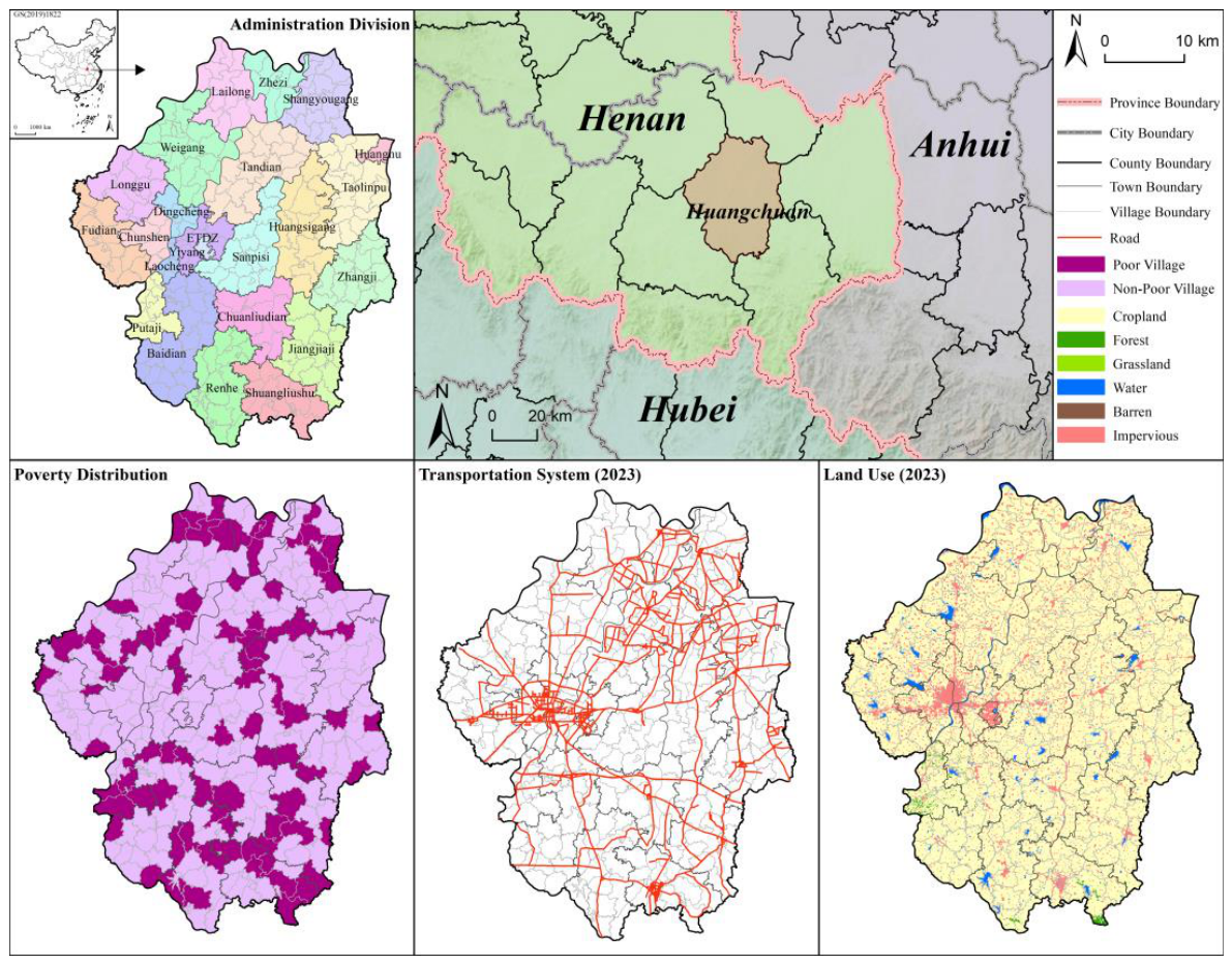
2.1. Study Area
2.2. Methods
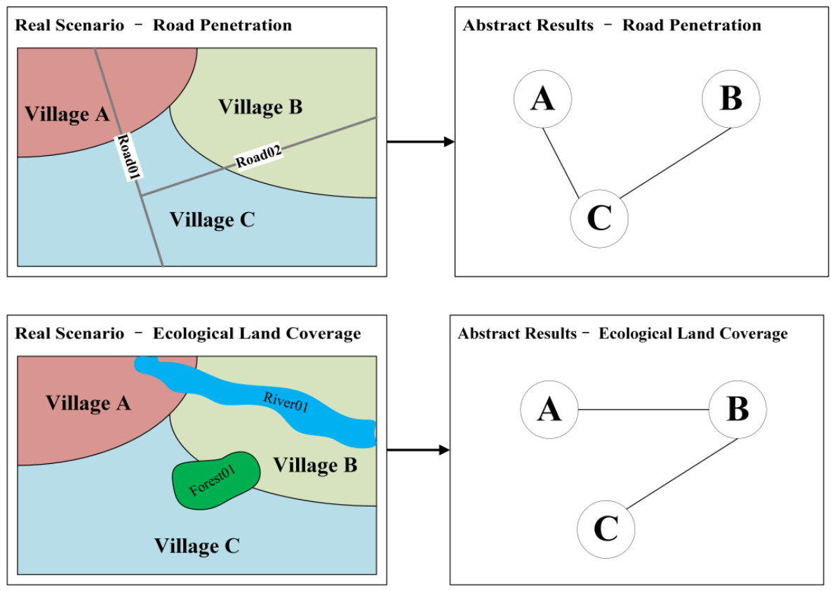
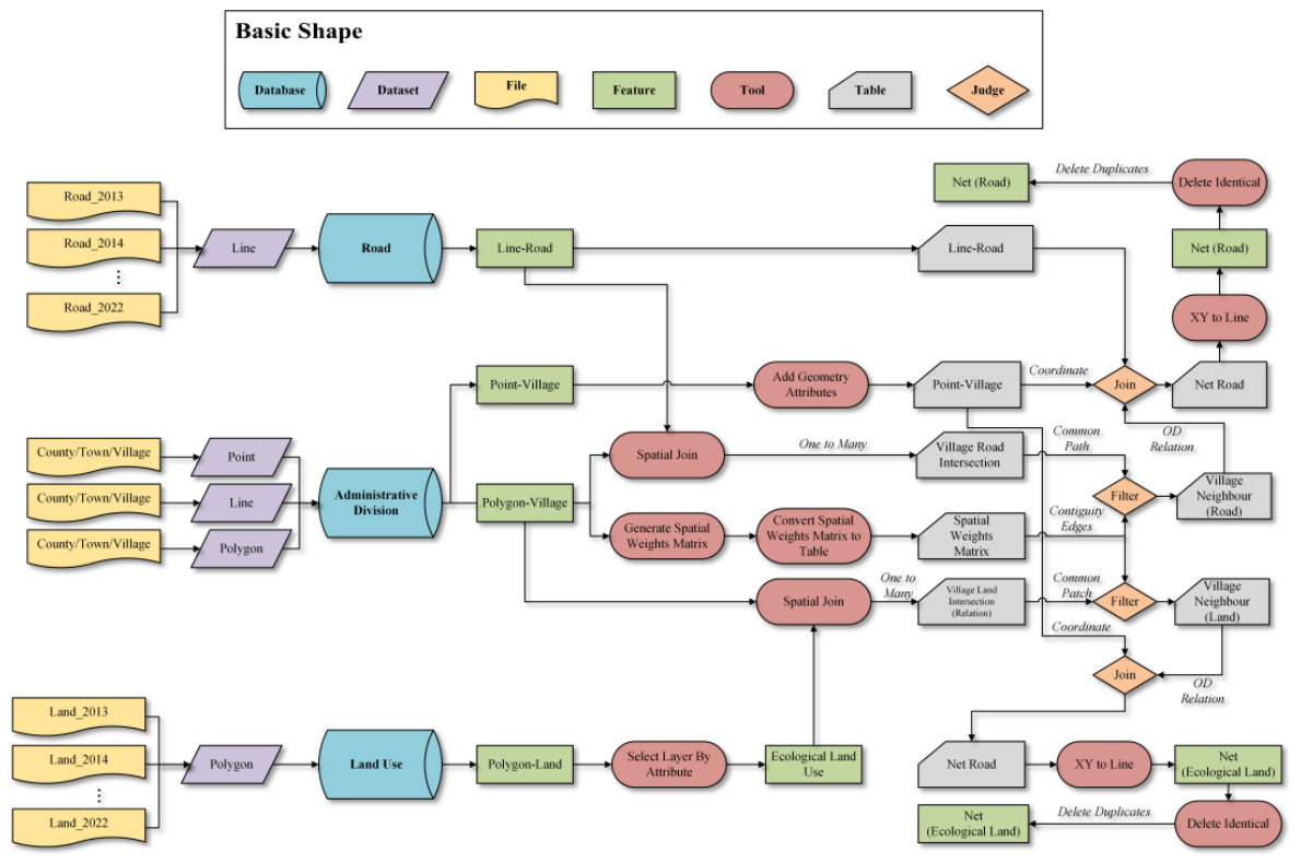
2.2.1. The Construction of Rural Network
2.2.2. Single Network Structure Measurement
2.2.3. Coupled Networks Synergy Measurement
2.2.4. Evolution Mechanism Analysis by ERGM
2.3. Data Source and Processing
3. Results
3.1. Basic Features of Network Construction
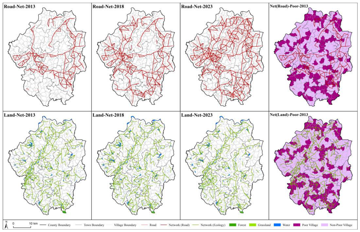
3.1.1. Relationships Between Rural Network and County Space
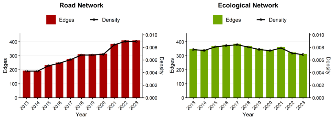
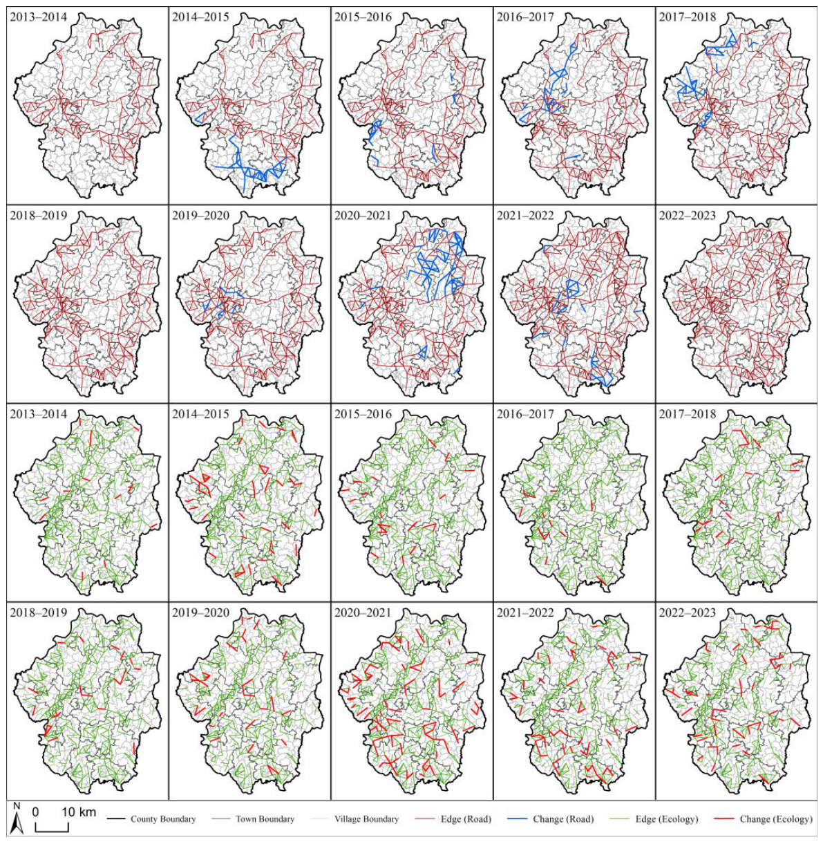
3.1.2. Variation in Network Connections
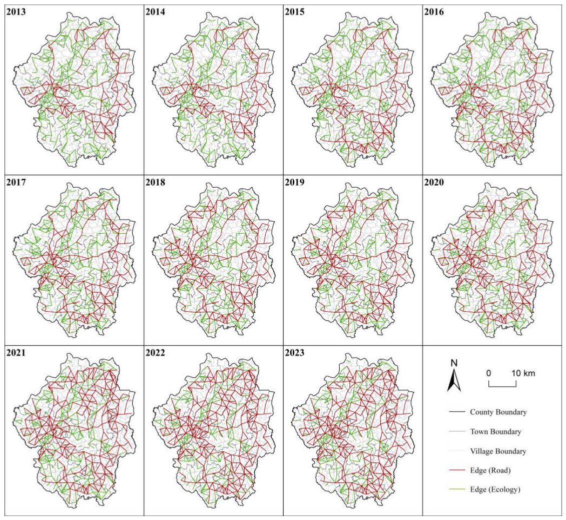
3.1.3. Spatial Pattern of Coupled Networks
3.2. Structural Measurement of Networks
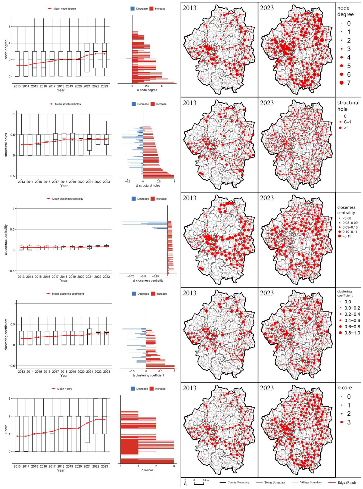
3.2.1. Structural Metrics of Road Networks
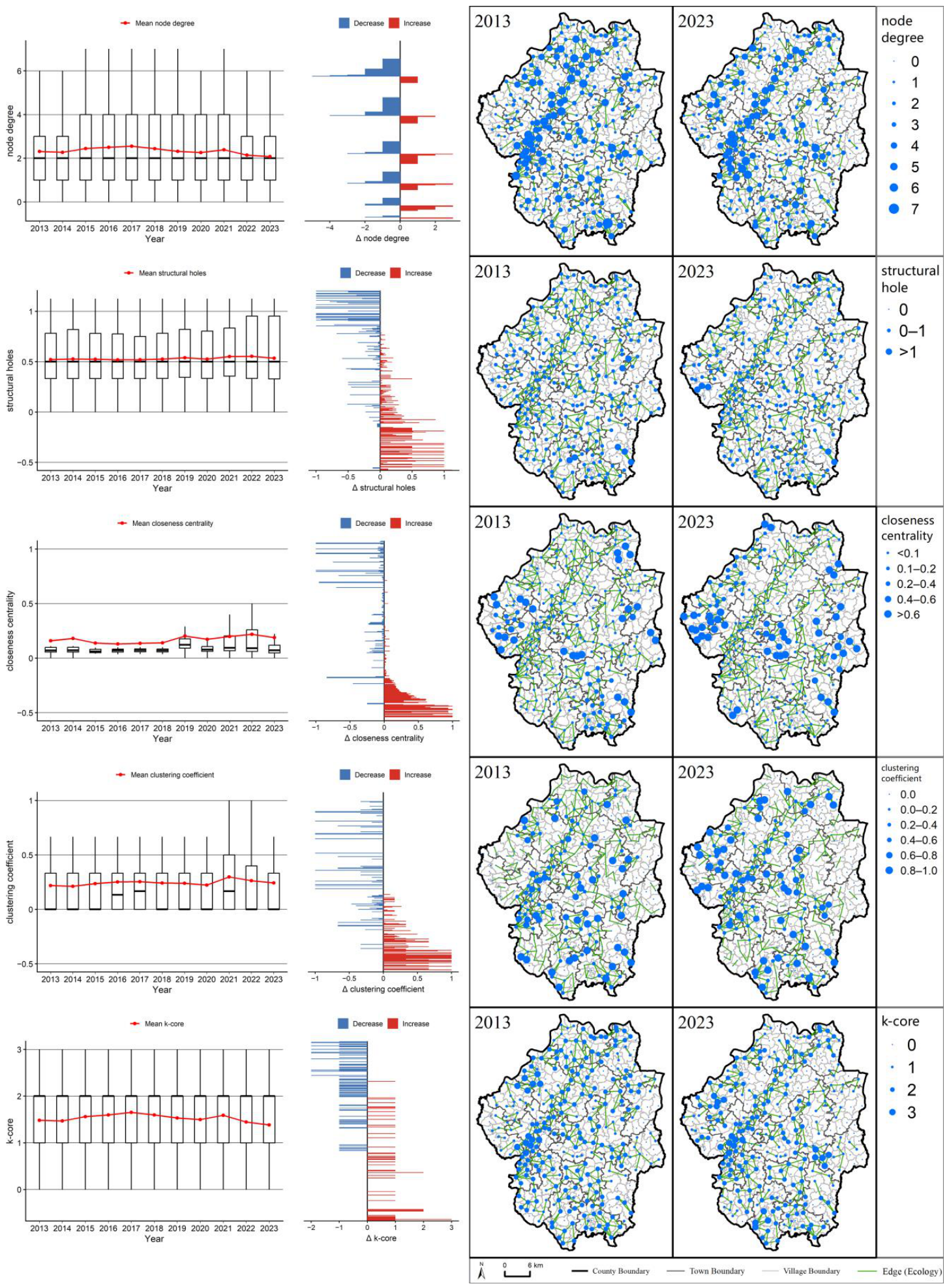
3.2.2. Structural Metrics of Ecological Networks
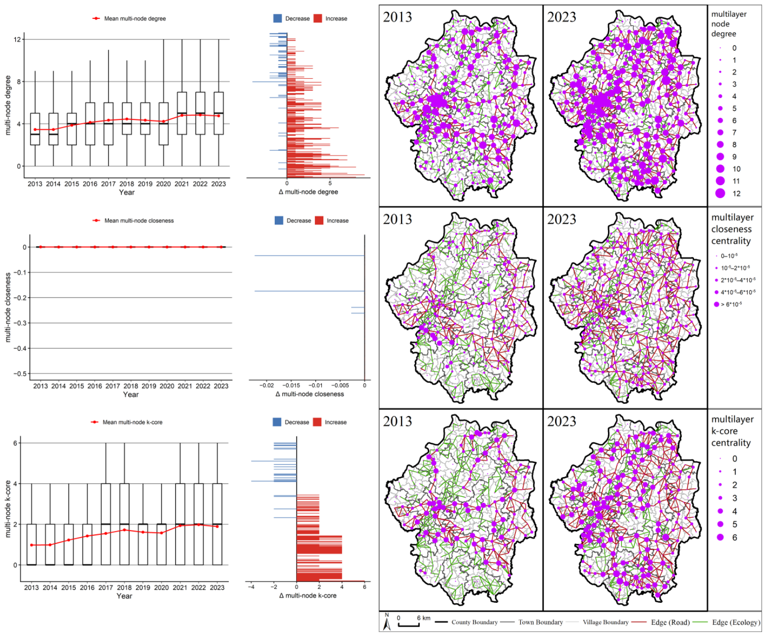
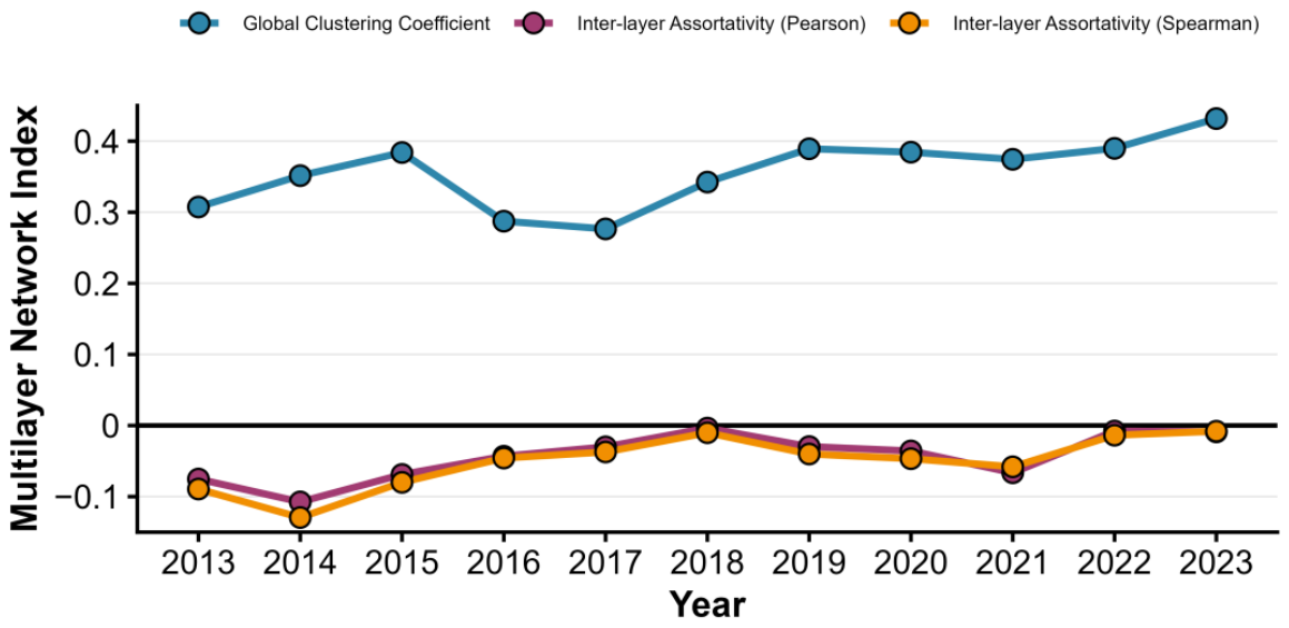
3.2.3. Structural Metrics of Coupled Networks
3.3. Analysis of Network Evolution Mechanisms
3.3.1. Evolution Mechanism of Road Networks
3.3.2. Evolution Mechanism of Ecological Networks
3.3.3. Evolution Mechanism of Coupled Networks
4. Discussion
4.1. Methodological Limitations and Implications for Result Interpretation
4.2. Theoretical Dialogue of Core Findings
4.3. Socio-Ecological Implications
5. Conclusions
Supplementary Materials
Author Contributions
Funding
Institutional Review Board Statement
Informed Consent Statement
Data Availability Statement
Acknowledgments
Conflicts of Interest
References
- Li, Y.; Westlund, H.; Liu, Y. Why Some Rural Areas Decline While Some Others Not: An Overview of Rural Evolution in the World. J. Rural Stud. 2019, 68, 135–143. [Google Scholar] [CrossRef]
- Dong, Y.; Cheng, P.; Kong, X. Spatially Explicit Restructuring of Rural Settlements: A Dual-Scale Coupling Approach. J. Rural Stud. 2022, 94, 239–249. [Google Scholar] [CrossRef]
- Yao, G.; Xie, H. Rural Spatial Restructuring in Ecologically Fragile Mountainous Areas of Southern China: A Case Study of Changgang Town, Jiangxi Province. J. Rural Stud. 2016, 47, 435–448. [Google Scholar] [CrossRef]
- Zhang, S.; Ma, W.; Wu, F.; Zhao, K. Unveiling the Impact of Transportation Infrastructure Construction on Rurality: A Case Study from Guangdong, China. Buildings 2024, 14, 2288. [Google Scholar] [CrossRef]
- Yin, J.; Wang, D.; Li, H. Spatial Optimization of Rural Settlements in Ecologically Fragile Regions: Insights from a Social-Ecological System. Habitat Int. 2023, 138, 102854. [Google Scholar] [CrossRef]
- Liu, Y.; Liu, Z.; Zhang, X. The Interactions between Road Networks and Ecological Corridors: A Novel Dual-Network Method. J. Transp. Geogr. 2026, 130, 104448. [Google Scholar] [CrossRef]
- Chen, N.; Kong, L. Rural Revitalization in China: Towards Inclusive Geographies of Ruralization. Dialogues Hum. Geogr. 2022, 12, 213–217. [Google Scholar] [CrossRef]
- Zhang, R.; Yuan, Y.; Li, H.; Hu, X. Improving the Framework for Analyzing Community Resilience to Understand Rural Revitalization Pathways in China. J. Rural Stud. 2022, 94, 287–294. [Google Scholar] [CrossRef]
- Sheng, S.; Lian, H. The Spatial Pattern Evolution of Rural Settlements and Multi-Scenario Simulations since the Initiation of the Reform and Opening up Policy in China. Land 2023, 12, 1763. [Google Scholar] [CrossRef]
- Zhang, X.; Pan, M. Emerging Rural Spatial Restructuring Regimes in China: A Tale of Three Transitional Villages in the Urban Fringe. J. Rural Stud. 2022, 93, 287–300. [Google Scholar] [CrossRef]
- Long, H. Theorizing Land Use Transitions: A Human Geography Perspective. Habitat Int. 2022, 128, 102669. [Google Scholar] [CrossRef]
- Ye, Q.; Li, J.; Kong, X.; Zhang, S. Identification and Optimization of the Spatial Structure of Urban and Rural Settlements from a Hierarchical Network Perspective. Land 2021, 10, 1177. [Google Scholar] [CrossRef]
- Cui, J.; Luo, J.; Kong, X.; Sun, J.; Gu, J. Characterising the Hierarchical Structure of Urban-Rural System at County Level Using a Method Based on Interconnection Analysis. J. Rural Stud. 2022, 93, 263–272. [Google Scholar] [CrossRef]
- Tian, Y.; Kong, X.; Liu, Y.; Wang, H. Restructuring Rural Settlements Based on an Analysis of Inter-Village Social Connections: A Case in Hubei Province, Central China. Habitat Int. 2016, 57, 121–131. [Google Scholar] [CrossRef]
- Wang, C.; Zhou, T.; Ren, M. Driving Spatial Network Connections in Rural Settlements: The Role of e-Commerce. Appl. Geogr. 2023, 159, 103067. [Google Scholar] [CrossRef]
- Zhou, J.; Hou, Q. Complex Network-Based Research on the Resilience of Rural Settlements in Sanshui Watershed. Land 2021, 10, 1068. [Google Scholar] [CrossRef]
- Liu, Z.; Wang, F.; Xue, P.; Xue, F. Using Multi-Layer Nested Network to Optimise Spatial Structure of Tourism Development between Urban and Rural Areas Based on Population Mobility. Indoor Built Environ. 2022, 31, 1028–1046. [Google Scholar] [CrossRef]
- Timóteo, S.; Correia, M.; Rodríguez-Echeverría, S.; Freitas, H.; Heleno, R. Multilayer Networks Reveal the Spatial Structure of Seed-Dispersal Interactions across the Great Rift Landscapes. Nat. Commun. 2018, 9, 140. [Google Scholar] [CrossRef] [PubMed]
- Zhang, S.; Chen, Y.; Zhang, X. Spatial Restructuring and Development Characteristics of Villages and the Revitalization Path: A Case Study of the X County of Zhejiang Province in China. Front. Sustain. Cities 2024, 6, 1441750. [Google Scholar] [CrossRef]
- Jiang, Y.; Long, H.; Tang, Y.; Deng, W. Deciphering How Promoting Land Consolidation for Village Revitalization in Rural China: A Comparison Study. J. Rural Stud. 2024, 110, 103349. [Google Scholar] [CrossRef]
- Yu, C.; Gao, J.; Zhang, X.; Sun, J. Policy Connection Path of Pairing Assistance in the County During the Post-poverty Era: A Case Study of Huangchuan County of Henan Province. Econ. Geogr. 2022, 42, 19–26. (In Chinese) [Google Scholar]
- Yu, C.; Han, Z.; Gao, J.; Zheng, Q.; Zhang, X.; Gao, H. Mechanisms of Rural Sustainable Development Driven by Land Use Restructuring: A Perspective of “Scale-Space” Interactions. Sustainability 2023, 15, 12600. [Google Scholar] [CrossRef]
- Yu, C.; Zhou, Z.; Gao, J. Rural Network Resilience: A New Tool for Exploring the Mechanisms and Pathways of Rural Sustainable Development. Sustainability 2024, 16, 5850. [Google Scholar] [CrossRef]
- Zhou, J.; Hou, Q. Resilience Assessment and Planning of Suburban Rural Settlements Based on Complex Network. Sustain. Prod. Consum. 2021, 28, 1645–1662. [Google Scholar] [CrossRef]
- Zhou, J.; Hou, Q.; Li, W. Spatial Resilience Assessment and Optimization of Small Watershed Based on Complex Network Theory. Ecol. Indic. 2022, 145, 109730. [Google Scholar] [CrossRef]
- De Domenico, M.; Porter, M.A.; Arenas, A. MuxViz: A Tool for Multilayer Analysis and Visualization of Networks. J. Complex Netw. 2015, 3, 159–176. [Google Scholar] [CrossRef]
- Long, H.; Tu, S.; Ge, D.; Li, T.; Liu, Y. The Allocation and Management of Critical Resources in Rural China under Restructuring: Problems and Prospects. J. Rural Stud. 2016, 47, 392–412. [Google Scholar] [CrossRef]
- Robins, G.; Pattison, P.; Kalish, Y.; Lusher, D. An Introduction to Exponential Random Graph (p*) Models for Social Networks. Soc. Netw. 2007, 29, 173–191. [Google Scholar] [CrossRef]
- Barrington-Leigh, C.; Millard-Ball, A. The World’s User-Generated Road Map Is More than 80% Complete. PLoS ONE 2017, 12, e0180698. [Google Scholar] [CrossRef] [PubMed]
- Xie, F.; Levinson, D. Modeling the Growth of Transportation Networks: A Comprehensive Review. Netw. Spat. Econ. 2009, 9, 291–307. [Google Scholar] [CrossRef]
- Opsahl, T.; Agneessens, F.; Skvoretz, J. Node Centrality in Weighted Networks: Generalizing Degree and Shortest Paths. Soc. Netw. 2010, 32, 245–251. [Google Scholar] [CrossRef]
- Ao, X.; Li, Q.; Schwanen, T.; Wójcik, D. Does Polycentric Regional Development Promote Economic Resilience? Empirical Evidence from Urban Agglomerations in China. J. Econ. Geogr. 2025, 25, 749–770. [Google Scholar] [CrossRef]
- Pan, J.; Liang, J.; Zhao, C. Identification and Optimization of Ecological Security Pattern in Arid Inland Basin Based on Ordered Weighted Average and Ant Colony Algorithm: A Case Study of Shule River Basin, NW China. Ecol. Indic. 2023, 154, 110588. [Google Scholar] [CrossRef]
- Zhang, Y.; Cao, Y.; Huang, Y.; Wu, J. Integrating Ecosystem Services and Complex Network Theory to Construct and Optimize Ecological Security Patterns: A Case Study of Guangdong-Hong Kong-Macao Greater Bay Area, China. Environ. Sci. Pollut. Res. 2023, 30, 76891–76910. [Google Scholar] [CrossRef] [PubMed]
- Yu, C.; Gao, J.; Han, Y.; Wang, Y.; Sun, J. Eliminating Deprivation and Breaking through Dependence: A Mechanism to Help Poor Households Achieve Sustainable Livelihoods by Targeted Poverty Alleviation Strategy. Growth Change 2022, 53, 1436–1456. [Google Scholar] [CrossRef]
- Kaiser, N.; Barstow, C.K. Rural Transportation Infrastructure in Low- and Middle-Income Countries: A Review of Impacts, Implications, and Interventions. Sustainability 2022, 14, 2149. [Google Scholar] [CrossRef]
- Rodriguez Antuñano, I. Vulnerability Assessment of Urban Infrastructure from Remote Sensing Data Using Advanced Analysis Techniques. Ph.D. Thesis, Universidad de Vigo, Vigo, Spain, 2024. Available online: http://hdl.handle.net/11093/8872 (accessed on 5 July 2026).
- Schlosberg, D. Defining Environmental Justice: Theories, Movements, and Nature; Oxford University Press: Oxford, UK, 2007. [Google Scholar]
- Pereira, R.H.M.; Schwanen, T.; Banister, D. Distributive Justice and Equity in Transportation. Transp. Rev. 2017, 37, 170–191. [Google Scholar] [CrossRef]
- Willberg, E.; Tenkanen, H.; Miller, H.J.; Pereira, R.H.M.; Toivonen, T. Measuring Just Accessibility within Planetary Boundaries. Transp. Rev. 2024, 44, 140–166. [Google Scholar] [CrossRef]
- Rodríguez Antuñano, I. Right to the City? A Look at the Distribution of Green Spaces in Barcelona from the Perspective of Environmental Justice. Master’s Thesis, Universitat Politècnica de Catalunya, Barcelona, Spain, 2019. Available online: https://hdl.handle.net/2117/179480 (accessed on 5 July 2026).
- Chowkwanyun, M. Environmental Justice: Where It Has Been, and Where It Might Be Going. Annu. Rev. Public Health 2023, 44, 93–111. [Google Scholar] [CrossRef] [PubMed]





| Attribute | Indicator | Function | Explanation |
|---|---|---|---|
| Independence | Multilayer Node Degree | GetMultiDegree | Measures the total connection count of a node in the road ecology multilayer network. A higher value represents stronger cross-layer external connection capacity and higher independence of rural nodes. |
| Collaboration | Multilayer Assortativity | GetInterAssortativityTensor | Analyzes the assortative matching preference of nodes by connection degree in the multilayer network. A positive value indicates that high-degree nodes tend to connect with similar nodes, reflecting the matching mode of rural cross-layer collaboration. |
| Connectivity | Multilayer Closeness Centrality | GetMultiClosenessCentrality | Measures multilayer harmonic closeness centrality, computed as the average of reciprocal shortest-path distances from a node to all other nodes across all network layers. Unlike the classic Bavelas closeness used in single-layer analysis (the reciprocal of average distance), this harmonic formulation maintains robust and valid measurement even for node pairs that are unreachable across layers. A higher value indicates stronger global cross-layer accessibility of rural nodes. |
| Dependence | Global Clustering Coefficient | GetAverageGlobalClustering | Reflects the tightness of local connections among nodes in the multilayer network. A higher value indicates closer cross-layer connections between rural nodes and neighboring nodes, as well as stronger interdependence. |
| Stability | Multilayer K-Core Centrality | GetMultiKCoreCentrality | Identifies stable core nodes in the multilayer network. A higher value indicates a stronger anti-interference ability of nodes in the cross-layer network, which supports the overall stability of the rural network. |
| Indicator | Parameter Setting | Processing Method |
|---|---|---|
| Edges | Count of all undirected edges | Controls baseline network density |
| GWESP | Decay parameter fixed at 0.25 | Captures triadic closure tendency |
| Kstar2 | Star order set to 2 | Captures overall network centralization |
| Altkstar | Decay parameter fixed at 0.5 | Captures degree hierarchical differentiation |
| Poor Village | Binary: 1 = poor village, 0 = non-poor village | Tests tie-formation preference by village type |
| Population Ratio | Continuous: village population share of the county | Controls population size effects on tie formation |
| Ecological Land Ratio | Continuous: ecological land share of each village | Controls land-use structure effects on tie formation |
| Category | Type | Source | Processing Method |
|---|---|---|---|
| Map Imagery | Land Use | China Land Cover Dataset (CLCD) | Collect and construct the county-level ecological network from 2013 to 2023 |
| Administrative Division | Tianditu Geographic Information Sharing Service Platform | Redraw administrative boundaries at county, township and village levels | |
| Road Network | OpenStreetMap (OSM) | Collect and construct the county-level road network from 2013 to 2023 | |
| Statistical Documentation | Socioeconomic Indicators | Statistical Bulletin | Sort out statistical indicators |
| Poverty Alleviation Policies | Investigation by Relevant Departments | Organize poverty alleviation policy implementation records | |
| Development Status | Government Work Report | Summarize regional development trends |
| Indicator | 2013 | 2014 | 2015 | 2016 | 2017 | 2018 | 2019 | 2020 | 2021 | 2022 | 2023 |
|---|---|---|---|---|---|---|---|---|---|---|---|
| Edges | −6.623 *** (0.251) | −6.621 *** (0.251) | −6.231 *** (0.241) | −6.077 *** (0.236) | −6.286 *** (0.252) | −5.847 *** (0.262) | −5.886 *** (0.264) | −6.080 *** (0.271) | −5.776 *** (0.273) | −5.713 *** (0.285) | −5.688 *** (0.270) |
| GWESP | 2.088 *** (0.078) | 2.087 *** (0.078) | 2.212 *** (0.072) | 2.268 *** (0.072) | 2.501 *** (0.126) | 2.491 *** (0.122) | 2.480 *** (0.120) | 2.453 *** (0.117) | 2.499 *** (0.112) | 2.485 *** (0.109) | 2.480 *** (0.109) |
| Kstar2 | −0.067 (0.046) | −0.067 (0.046) | −0.070 (0.040) | −0.053 (0.038) | −0.107 *** (0.029) | −0.148 *** (0.031) | −0.149 *** (0.030) | −0.147 *** (0.031) | −0.162 *** (0.028) | −0.171 *** (0.028) | −0.172 *** (0.026) |
| Altkstar | 1.042 *** (0.140) | 1.042 *** (0.140) | 0.625 *** (0.130) | 0.360 ** (0.124) | 0.352 (0.270) | 0.120 (0.251) | 0.120 (0.257) | 0.266 (0.261) | 0.175 (0.247) | 0.194 (0.247) | 0.188 (0.245) |
| Poor village | −0.248 (0.160) | −0.246 (0.160) | −0.148 (0.142) | −0.164 (0.137) | −0.217 ** (0.083) | −0.226 ** (0.086) | −0.215 * (0.085) | −0.215 * (0.085) | −0.110 (0.079) | −0.082 (0.079) | −0.089 (0.072) |
| Population Ratio | 22.87 (18.12) | 23.21 (17.82) | 19.38 (17.26) | 12.43 (16.80) | 42.69 *** (12.53) | 51.29 *** (12.67) | 58.49 *** (14.05) | 71.60 *** (16.22) | 58.34 *** (15.89) | 61.75 *** (16.11) | 61.88 *** (15.24) |
| Ecological Land Ratio | −3.331 *** (0.975) | −3.352 *** (0.978) | −3.478 *** (0.917) | −2.369 *** (0.665) | −1.986 *** (0.438) | −2.081 *** (0.451) | −2.257 *** (0.480) | −2.320 *** (0.507) | −1.845 *** (0.340) | −1.946 *** (0.372) | −2.174 *** (0.402) |
| AIC | 1358.526 | 1358.139 | 1535.238 | 1633.553 | 2682.606 | 2986.908 | 2981.169 | 3014.804 | 3546.67 | 3739.414 | 3730.831 |
| Geweke | — | — | — | — | 0.307 | 0.797 | 0.561 | 0.174 | 0.589 | 0.818 | 0.251 |
| GOF | — | — | — | — | 0.740 | 0.980 | 0.800 | 0.840 | 0.900 | 0.900 | 0.780 |
| Indicator | 2013 | 2014 | 2015 | 2016 | 2017 | 2018 | 2019 | 2020 | 2021 | 2022 | 2023 |
|---|---|---|---|---|---|---|---|---|---|---|---|
| Edges | −5.524 *** (0.270) | −5.355 *** (0.265) | −5.288 *** (0.272) | −5.197 *** (0.276) | −5.297 *** (0.281) | −5.424 *** (0.279) | −5.442 *** (0.272) | −5.615 *** (0.278) | −5.374 *** (0.277) | −5.545 *** (0.269) | −5.673 *** (0.270) |
| GWESP | 1.954 *** (0.088) | 1.970 *** (0.092) | 2.045 *** (0.089) | 2.070 *** (0.089) | 2.108 *** (0.089) | 2.064 *** (0.091) | 2.152 *** (0.098) | 2.082 *** (0.093) | 2.294 *** (0.101) | 2.247 *** (0.103) | 2.204 *** (0.103) |
| Kstar2 | −0.174 *** (0.035) | −0.161 *** (0.035) | −0.188 *** (0.034) | −0.209 *** (0.034) | −0.213 *** (0.034) | −0.203 *** (0.034) | −0.205 *** (0.036) | −0.201 *** (0.036) | −0.219 *** (0.035) | −0.195 *** (0.037) | −0.160 *** (0.036) |
| Altkstar | 0.163 (0.234) | −0.083 (0.236) | 0.042 (0.237) | 0.052 (0.232) | 0.139 (0.235) | 0.248 (0.236) | 0.008 (0.236) | 0.201 (0.238) | −0.070 (0.236) | −0.118 (0.237) | −0.145 (0.240) |
| Poor village | 0.058 (0.084) | 0.069 (0.086) | 0.075 (0.081) | 0.090 (0.083) | 0.095 (0.084) | 0.077 (0.085) | 0.124 (0.085) | 0.063 (0.085) | 0.059 (0.082) | 0.059 (0.084) | 0.118 (0.080) |
| Population Ratio | 44.69 ** (14.07) | 40.48 ** (13.73) | 36.23 ** (13.45) | 36.48 ** (14.00) | 39.51 ** (14.16) | 35.96 * (14.41) | 47.82 ** (15.07) | 54.74 ** (18.02) | 49.92 ** (17.93) | 52.49 ** (17.52) | 49.24 ** (17.43) |
| Ecological Land Ratio | 0.333 (0.216) | 0.317 (0.220) | 0.125 (0.178) | 0.066 (0.189) | 0.029 (0.185) | 0.046 (0.189) | 0.114 (0.191) | 0.078 (0.192) | 0.061 (0.194) | 0.189 (0.191) | 0.238 (0.203) |
| AIC | 3627.267 | 3581.731 | 3748.234 | 3802.614 | 3830.651 | 3719.294 | 3547.535 | 3502.754 | 3563.959 | 3298.34 | 3233.723 |
| Geweke | 0.776 | 0.034 | 0.243 | 0.360 | 0.103 | 0.576 | 0.712 | 0.271 | 0.931 | 0.291 | 0.474 |
| GOF | 0.940 | 0.800 | 0.920 | 0.860 | 0.780 | 0.880 | 0.900 | 0.800 | 0.920 | 0.800 | 0.860 |
| Indicator | 2013 | 2014 | 2015 | 2016 | 2017 | 2018 | 2019 | 2020 | 2021 | 2022 | 2023 |
|---|---|---|---|---|---|---|---|---|---|---|---|
| Edges | −4.908 *** (0.284) | −4.756 *** (0.288) | −4.733 *** (0.295) | −4.756 *** (0.301) | −4.606 *** (0.304) | −4.611 *** (0.313) | −4.572 *** (0.300) | −4.685 *** (0.307) | −4.561 *** (0.336) | −4.753 *** (0.317) | −4.659 *** (0.309) |
| GWESP | 2.180 *** (0.089) | 2.209 *** (0.090) | 2.413 *** (0.095) | 2.528 *** (0.096) | 2.571 *** (0.098) | 2.561 *** (0.098) | 2.568 *** (0.098) | 2.531 *** (0.099) | 3.004 *** (0.118) | 2.903 *** (0.112) | 2.863 *** (0.113) |
| Kstar2 | −0.252 *** (0.031) | −0.246 *** (0.031) | −0.267 *** (0.030) | −0.266 *** (0.029) | −0.287 *** (0.030) | −0.297 *** (0.032) | −0.293 *** (0.032) | −0.278 *** (0.030) | −0.303 *** (0.032) | −0.283 *** (0.029) | −0.267 *** (0.028) |
| Altkstar | 0.158 (0.230) | −0.072 (0.234) | 0.035 (0.230) | 0.010 (0.232) | −0.087 (0.234) | 0.027 (0.229) | −0.143 (0.227) | −0.090 (0.231) | −0.313 (0.228) | −0.149 (0.233) | −0.364 (0.233) |
| Poor village | −0.088 (0.081) | −0.065 (0.081) | −0.047 (0.080) | −0.054 (0.079) | −0.006 (0.082) | −0.055 (0.081) | −0.053 (0.083) | −0.097 (0.076) | −0.009 (0.079) | −0.046 (0.082) | −0.012 (0.076) |
| Population Ratio | 62.47 *** (14.58) | 60.44 *** (14.22) | 56.68 *** (14.21) | 53.71 *** (15.10) | 63.90 *** (14.57) | 65.90 *** (14.62) | 75.07 *** (16.11) | 79.25 *** (18.53) | 69.48 *** (17.76) | 66.78 *** (18.29) | 69.01 *** (17.38) |
| Ecological Land Ratio | −0.418 (0.232) | −0.421 (0.235) | −0.629 ** (0.203) | −0.625 ** (0.197) | −0.672 *** (0.196) | −0.748 *** (0.201) | −0.761 *** (0.198) | −0.792 *** (0.205) | −0.927 *** (0.210) | −0.925 *** (0.203) | −0.967 *** (0.221) |
| AIC | 4379.964 | 4365.757 | 4557.855 | 4611.804 | 4695.497 | 4704.609 | 4661.629 | 4669.038 | 4863.663 | 4842.154 | 4865.253 |
| Geweke | 0.993 | 0.637 | 0.545 | 0.286 | 0.067 | 0.282 | 0.539 | 0.068 | 0.100 | 0.931 | 0.082 |
| GOF | 0.840 | 0.900 | 0.880 | 0.960 | 0.860 | 0.800 | 0.880 | 0.920 | 0.920 | 0.820 | 0.940 |
Disclaimer/Publisher’s Note: The statements, opinions and data contained in all publications are solely those of the individual author(s) and contributor(s) and not of MDPI and/or the editor(s). MDPI and/or the editor(s) disclaim responsibility for any injury to people or property resulting from any ideas, methods, instructions or products referred to in the content. |
© 2026 by the authors. Licensee MDPI, Basel, Switzerland. This article is an open access article distributed under the terms and conditions of the Creative Commons Attribution (CC BY) license.
Share and Cite
Yu, C.; Yang, C.; Gao, J.; Zhou, Z.; Li, Y.; He, C.; Fang, Y.; Wu, J. Road-Ecology Coupled Networks and the Evolution of County Spatial Structure. Sustainability 2026, 18, 7065. https://doi.org/10.3390/su18147065
Yu C, Yang C, Gao J, Zhou Z, Li Y, He C, Fang Y, Wu J. Road-Ecology Coupled Networks and the Evolution of County Spatial Structure. Sustainability. 2026; 18(14):7065. https://doi.org/10.3390/su18147065
Chicago/Turabian StyleYu, Chao, Chenao Yang, Junbo Gao, Zhiyuan Zhou, Yi Li, Caoying He, Yinyao Fang, and Jinrun Wu. 2026. "Road-Ecology Coupled Networks and the Evolution of County Spatial Structure" Sustainability 18, no. 14: 7065. https://doi.org/10.3390/su18147065
APA StyleYu, C., Yang, C., Gao, J., Zhou, Z., Li, Y., He, C., Fang, Y., & Wu, J. (2026). Road-Ecology Coupled Networks and the Evolution of County Spatial Structure. Sustainability, 18(14), 7065. https://doi.org/10.3390/su18147065