1. Introduction
Natural disasters are indeed one of the leading causes of tragedies experienced globally, and their impacts deeply permeate the socio-economic structure of cities. Among these effects are significant consequences such as loss of life, damage to physical infrastructure, rendering settlements uninhabitable, and forcing people to leave their homes [
1,
2,
3]. According to data from the Internal Displacement Monitoring Centre (IDMC), in the year 2024, a total of 65.8 million people experienced displacement due to conflict or natural disasters [
4]. The number of individuals displaced from their living areas due to natural disasters was 45.8 million. Consequently, the movements of populations displaced by conflict or natural disasters are a notable global issue. Natural disasters such as earthquakes can render settlements uninhabitable by creating significant changes in the built environment [
5,
6] and displacing populations due to the destruction of living spaces [
7].
Researchers from various countries provide insights into processes of displacement resulting from natural disasters. One of the most critical tasks for governments following displacement processes is the successful implementation of reconstruction efforts. In this context, He et al. (2018) [
8] emphasize the need for community-centred general reconstruction policies that not only rebuild housing but also enhance local capacity to minimize vulnerability in the long term following earthquakes. However, contrary to this assertion, Badri et al. (2006) [
9] and Dickinson (2013) [
10] point out a significant gap in the literature regarding the post-disaster reconstruction process. Supporting these authors, [
10] notes that the processes influencing decision-making at different stages of post-disaster reconstruction are not adequately illuminated.
Considering the weakness in understanding decision-making mechanisms following earthquakes in the literature, this study focuses on İzmir, which is highly prone to seismic risks. The Aegean Sea and the Eastern Mediterranean basin are characterized by an active tectonic structure and therefore exhibit significant seismic activity, having historically experienced various destructive earthquakes [
11]. In this context, two major earthquakes occurred in 2014 (Mw 6.9) and 2017 (Mw 6.6), demonstrating that the region is a high seismic risk area. The city was affected by an earthquake with a magnitude of 6.9 Mw in the Aegean Sea on 30 October 2020. Numerous buildings collapsed, particularly in the Bayraklı district of İzmir, where, according to the Disaster and Emergency Management Presidency (AFAD) data, 117 people lost their lives, and 1034 were injured. Following such significant earthquakes, attention is often focused on the intensity of the earthquake and the condition of physical structures, both in academic circles and in written/visual media. However, the experiences of different population groups affected by the earthquake, especially those whose homes were destroyed or rendered uninhabitable, are often neglected.
This article addresses the post-earthquake process, which seems to be overlooked in international and national literature, from the perspective of displacement and residential mobility. The study area comprises the Mansuroğlu and Manavkuyu neighbourhoods, which were the most affected by the earthquake in İzmir. The research questions identified in the study are as follows: How did displacement processes following the 2020 Aegean Sea Earthquake create spatial mobility? What criteria play a role in the location selection preferences in the movements that occurred? What societal and spatial problems were encountered after the earthquake?
The study begins with the Introduction section, followed by the section discussing the Outputs Regarding Post-Earthquake Effects: Who Is Affected How? The second section is devoted to Methodology. In this section, the acquisition, analysis, and visualization process of primary and secondary datasets are presented in detail. The next section is Findings and Discussion. In this section, the outputs obtained from the analysis of the dataset in the study are presented in conjunction with the relevant literature. Additionally, this section presents the similarities and differences between general mobility patterns and the literature. The study concludes with the conclusion section.
2. Outputs Regarding Post-Earthquake Effects: Who Was Affected and How?
One of the most tangible outcomes of the destructive effects of disasters on living spaces is the occurrence of displacement processes and population movements due to the devastation of these areas [
4,
7,
12]. Countries that lag in terms of the negative impacts of displacement processes are often more affected [
8,
13,
14].
Especially as the impact power of disasters such as earthquakes increases, disruptions in daily life become more pronounced. Roberts (1994) [
15] emphasizes the critical importance of taking action to mitigate the impact of adverse events on low-income households. In this regard, migrations that occur after natural disasters are one of the first and most effective ways to respond to disasters. However, Fernando et al. (2010) [
16] argue that the real worst-case scenario arises when there is an inability to adapt to the destination. Their research, conducted using the example of Sri Lanka, suggests that disagreements with the host community and differences in economic activities contribute to the creation of the mentioned bleak picture.
One of the primary effects created by natural disasters parallel to physical destruction is property change. Following sudden natural disasters, homeowners can fall into the position of short- or long-term tenants due to physical damage to their homes. In some cases, this situation can result in the permanent loss of property due to the effects of the disaster. The situation of tenants before or after the disaster is more ambiguous. Among the primary reasons for this ambiguity is the higher tendency of this group to make permanent movements due to their lower attachment to property [
17]. This situation not only leads to rapid positioning but also poses a significant challenge for researchers in terms of spatial tracing. Therefore, Quarantelli (1985) [
18] states that homeowners may engage in construction activities after the disaster, while tenants may take longer to acquire permanent housing and may not necessarily return to their old places.
In addition to mobility following natural disasters, immobility is also a choice. High attachment to place makes it possible for those affected by disasters to choose to stay rather than migrate [
19,
20,
21,
22]. In addition, in some cases, place attachment also creates a strong desire to return [
23]. Xu et al. (2017) [
20] conducted a study in the villages of Fengjie and Wanzhou in China and found that households with a high sense of place identity were more reluctant to relocate. At this stage, the village is not only a place of residence and livelihood but also a social space where everyday life unfolds. The appropriation of the village as a social space diminishes households’ willingness to move elsewhere. Similarly, Lie et al. (2023) [
22], in their study conducted in two small settlements in Norway, demonstrated that relocation—typically considered a reflexive response to improvement—was not preferred in most cases. In this context, households showed reluctance to choose leaving as a coping strategy.
In addition to the aforementioned negative effects, natural disasters create impacts on some sub-parameters. The most prominent of these is the deterioration in economic conditions [
24,
25,
26]. Additionally, health problems after the disaster [
27,
28,
29] and disruptions in kinship and neighbourhood ties [
30] are noteworthy. These findings reinforce the ongoing relevance of the proposition that disadvantaged groups experience the effects of disasters more severely. To contribute to this discussion, Frey et al. (2013) [
31] examine the conditions of various groups following Hurricane Katrina. The authors note that those who remained in New Orleans post-disaster were older, wealthier, and had fewer children. Conversely, those who migrated were younger, poorer, of African descent, and had more children. Thus, it is understood that the elderly are disadvantaged compared to the young, the poor compared to the wealthy, African Americans compared to whites, and larger families compared to smaller ones.
To prevent the emergence of all the mentioned negative effects, post-disaster reconstruction processes raise the issue of effective intervention by states [
10,
32]. Local and national authorities of countries experiencing disasters should establish effective and participatory mechanisms in relocation programmes and reconstruction processes in disaster areas. Research on the reconstruction processes of the 1990 Manjil Earthquake (Iran) conducted over 11 years Badri et al. (2006) [
9] emphasizes that the government bears a certain cost for unsuccessful relocation processes. The mentioned failures are characterized by socio-economic developments characterized by employment, income loss, women’s employment, and lifestyle changes that were reluctantly relocated. Mushtaha et al. (2025) [
32] discuss the role of the state and institutions through the lens of post-disaster reconstruction processes. Based on the insights of 273 experts specialized in post-disaster recovery, the study highlights that accessibility for emergency response teams, population distribution, and the needs of disadvantaged groups are considered critical factors in reconstruction efforts. In addition, the authors identify other key components of the recovery process, including access to funding, supply of materials, and public health concerns. The study ultimately provides guidance for policymakers and governmental actors on the strategic allocation of resources to ensure a resilient and equitable recovery in disaster-affected areas.
3. Data and Methods
3.1. Study Area
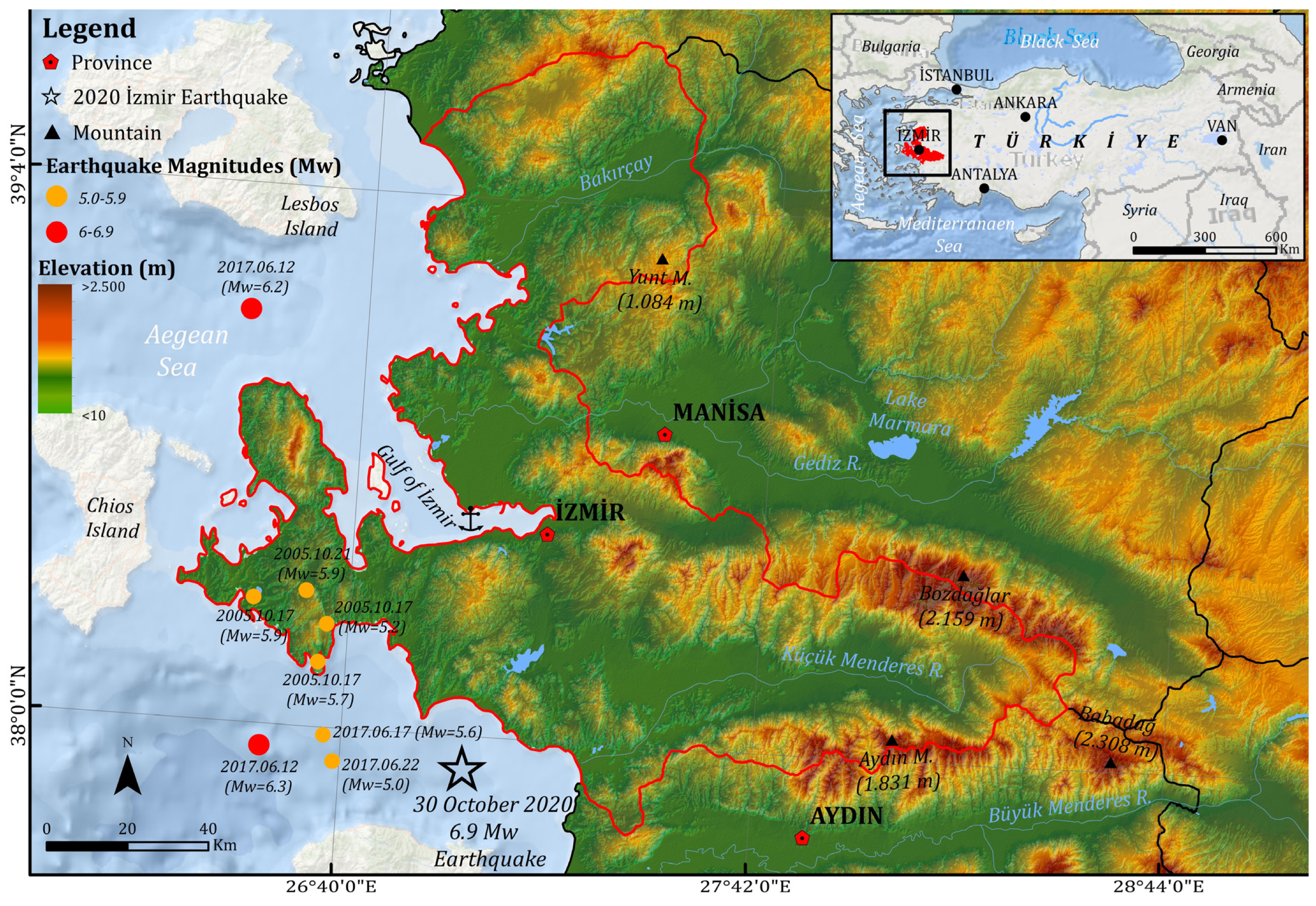
The study area consists of the Mansuroğlu and Manavkuyu neighbourhoods in Bayraklı, which is the most affected district of İzmir by the earthquake (
Figure 1). İzmir exhibits characteristics of a metropolitan city with small industrial towns, agricultural areas, and residential areas surrounding it. The population of İzmir, which was 153,845 in 1927, reached 227,578 in 1950, and with its metropolitan status acquired in 1981, it reached 1,489,772 in 1985 and 1,757,414 in 1990 [
33]. As of 2024, the population of İzmir was 4,493,242 [
34]. Following the earthquake on 30 October 2020, with a magnitude of 6.9 Mw in the Aegean Sea, numerous houses collapsed in the Bayraklı district of İzmir, resulting in 117 fatalities and 1034 injuries, according to the Disaster and Emergency Management Presidency (AFAD) data.
The development of the neighbourhoods belonging to the Bayraklı district, which is our study area, continued with the occupation of the base of the Bornova plain towards Manavkuyu–Salhane direction with increasing migrations in the 1950s. The Bornova plain was formed by the filling of this depression with alluvium brought by short, seasonal streams flowing from the surrounding high masses to the plain [
35].
3.2. Data
In the study, a micro dataset suitable for mapping was obtained from the İzmir Earthquake Victims Solidarity Association (IZDEDA) formed by the earthquake victims themselves in İzmir. The organization, operating in the capacity of an association, is organized through earthquake victims who apply to it and actively participates in the conduct of post-earthquake procedures. The raw dataset obtained includes information on the neighbourhood, street, and buildings of 1620 individuals who lived in Mansuroğlu and Manavkuyu before the earthquake, as well as information on the new settlement places after the earthquake, including province, district, and neighbourhood details. Although the dataset provides valuable insights into post-earthquake residential mobility patterns, it does not represent the entire population affected by the earthquake. Rather, it reflects the accessible displacement records available through IZDEDA during the study period. Therefore, the findings should be interpreted as indicative mobility patterns rather than universally generalizable conclusions. In addition, potential source bias should be considered, as some affected groups may be underrepresented due to differences in institutional access, reporting practices, or voluntary association participation.
The most affected areas of the earthquake are the Mansuroğlu and Manavkuyu neighbourhoods of the Bayraklı district. According to the report dated 26 April 2022, out of 213,767 buildings examined, 99 were classified as urgently collapsed, 632 as severely damaged, 598 as moderately damaged, and 7770 as slightly damaged. While movements at the district level indicate general trends, movements at the neighbourhood level have provided an opportunity for micro-level analysis.
In the study, distribution movements and the direction of this distribution were mapped using data containing 1620 registered displacement addresses. In addition, spatial statistical analyses such as mean centre, median centre, and standard ellipsoid were utilized to understand the geographical distribution of the dataset and determine the central tendency of the locations where earthquake victims moved. Standard deviations help you understand the distribution or spread of your data [
36]. In the two-dimensional movement data of earthquake victims, a new feature class was created, directional distribution (standard deviation ellipse), containing an elliptical polygon focused on the mean centre.
Spatial-temporal models help answer questions about when and where events occur, enabling the tracking of the movement of an event or feature’s mean location and predicting the future location and time of a similar event or feature [
37]. In this context, Moran I and Getis Ord G statistics were used to determine the spatial connections of high or low housing mobility values in the study area [
38].
Moran I provides values ranging from −1 (negative spatial autocorrelation) to +1 (positive spatial autocorrelation). A negative value in the Moran I index indicates that neighbouring values for movers are very different; positive values indicate clustering, and 0 indicates that the observed values are randomly distributed.
Getis Ord G aims to evaluate the spatial distribution of housing mobility in the study area after the earthquake. This analysis is an important spatial model that attempts to identify spatial patterns and clustering trends by identifying areas with low (cold spots) or high values (hotspots) in a region [
38]. High positive z values indicate that the spatial pattern consists of high-value clusters; conversely, low-value clusters are indicated in the opposite case [
38].
3.3. Sample and Qualitative Research Method
In this study, the causal factors underlying post-earthquake movements were analyzed using qualitative research methods. Qualitative research is a method employed to investigate the causality of a current situation or event, addressing the causality of events and situations [
39]. The primary focus is on the post-earthquake housing mobility of disaster victims, their experiences, and the criteria they consider in selecting new locations. However, identifying post-disaster movements faces certain challenges. One such challenge is the dispersion of many households within or outside the city during the research process, making it difficult to locate individuals. Atkinson (2000) [
40] defines this challenge as attempting to measure the “invisible.” Another challenge is the lack of comparative data that could reveal post-disaster mobility [
41]. To overcome this challenge, researchers develop different approaches; for example, researchers like Becker (2022) [
42] attempt to overcome this deficiency using methods such as network theory. Consequently, researchers develop various strategies to facilitate tracing post-disaster movements.
To overcome these challenges, individuals who were under the umbrella of the İzmir Earthquake Victims Solidarity Association (İZDEDA) and who maintained their relationship with the association after the earthquake were contacted. The primary challenge at this stage of sample selection was that some members had severed their relationship with the association or reduced their contact after the earthquake. Therefore, researchers opted for snowball sampling to reach individuals affected by the disaster. Snowball sampling is a preferred sampling method in revealing personal experiences [
43]. The critical point in this sampling method is that individuals within the network are interconnected [
44]. In addition to this approach, efforts were made to ensure heterogeneity in the sample by including participants with different socio-economic backgrounds, housing tenure types (homeowners and tenants), neighbourhoods, and post-earthquake mobility experiences in order to reduce potential network homogeneity and enhance analytical diversity.
The size of the sample was determined based on maximum saturation criteria. When convergence occurred in the responses received within the scope of the questions posed to the interviewers, the interviews were terminated. In this context, 26 semi-structured interviews were conducted with individuals affected by the earthquake in the Manavkuyu and Mansuroğlu neighbourhoods. The interviews were conducted in 2023, and the average duration of the interviews was 25 min.
The interviewers exhibit distinct characteristics in terms of demographic structure. The average age distribution of the interviewees indicates a predominance of individuals aged between 30 and 50 years. The distribution of birthplaces is compatible with the heterogeneous structure of İzmir’s migration process. Firstly, homeownership predominates in both neighbourhoods comprising the main mass. Secondly, limited tenants have formed a reflex of sudden and rapid relocation in post-earthquake mobility.
The reason for preferring semi-structured interviews in the study is due to the flexibility it allows researchers to add or remove questions according to the course of the interviews [
45]. The interview form consists of four main sections. The first section covers demographic information. The second section is created to reveal post-earthquake housing selection processes. In this section, questions aim to reveal post-earthquake urgent needs, frequency of changing residences after the earthquake, physical characteristics of new residences, and the situation of returning to old residences or neighbourhoods after reconstruction. The third section of the interview form is devoted to family, neighbourhood, and kinship relations. The final section aims to reveal the earthquake’s impact on work life and the economy. In this section, questions about changes in work life, losses/changes in economic incomes, and differentiation in household income levels are attempted to be revealed.
The analysis of the obtained interviews was conducted in two stages. In the first stage, recorded interviews were transcribed using Microsoft 365 programme. Transcript files were prepared for analysis, and in the second stage, they were coded using MAXQDA 2020 software. In the coding process, the inductive open coding method was preferred. As a result of the coding, four main themes were identified. The strongest theme of this study was housing situation, followed by institutional structure as the second theme, earthquake effects as the third theme, and earthquake memory as the last theme.
3.4. Methodological Triangulation
This study adopts a methodological triangulation approach by integrating quantitative spatial analysis with qualitative interview data to enhance the validity and interpretive depth of the findings. Rather than treating these two strands as separate analytical components, they are designed to be complementary and mutually reinforcing.
The spatial analysis provides a macro-level perspective on post-earthquake residential mobility patterns, including spatial clustering and intra-urban displacement trends. In contrast, the qualitative interviews offer micro-level insights into lived experiences, decision-making processes, and perceptions regarding housing availability, institutional response, and socio-economic constraints.
The integration of these two datasets allows for cross-validation of findings and a more comprehensive understanding of post-earthquake mobility dynamics in İzmir. In particular, spatial patterns identified through quantitative analysis are interpreted and contextualized through qualitative narratives, enabling a more robust explanation of observed mobility behaviours. This approach strengthens the overall methodological coherence of the study and improves the reliability of its empirical conclusions.
4. Results and Discussion
4.1. Who Went Where and Why? A Brief Look at Post-Disaster Mobility
From a unidirectional perspective, both long and short-distance movements are considered as a response to mitigate the effects of disasters. Fernando et al. (2010) [
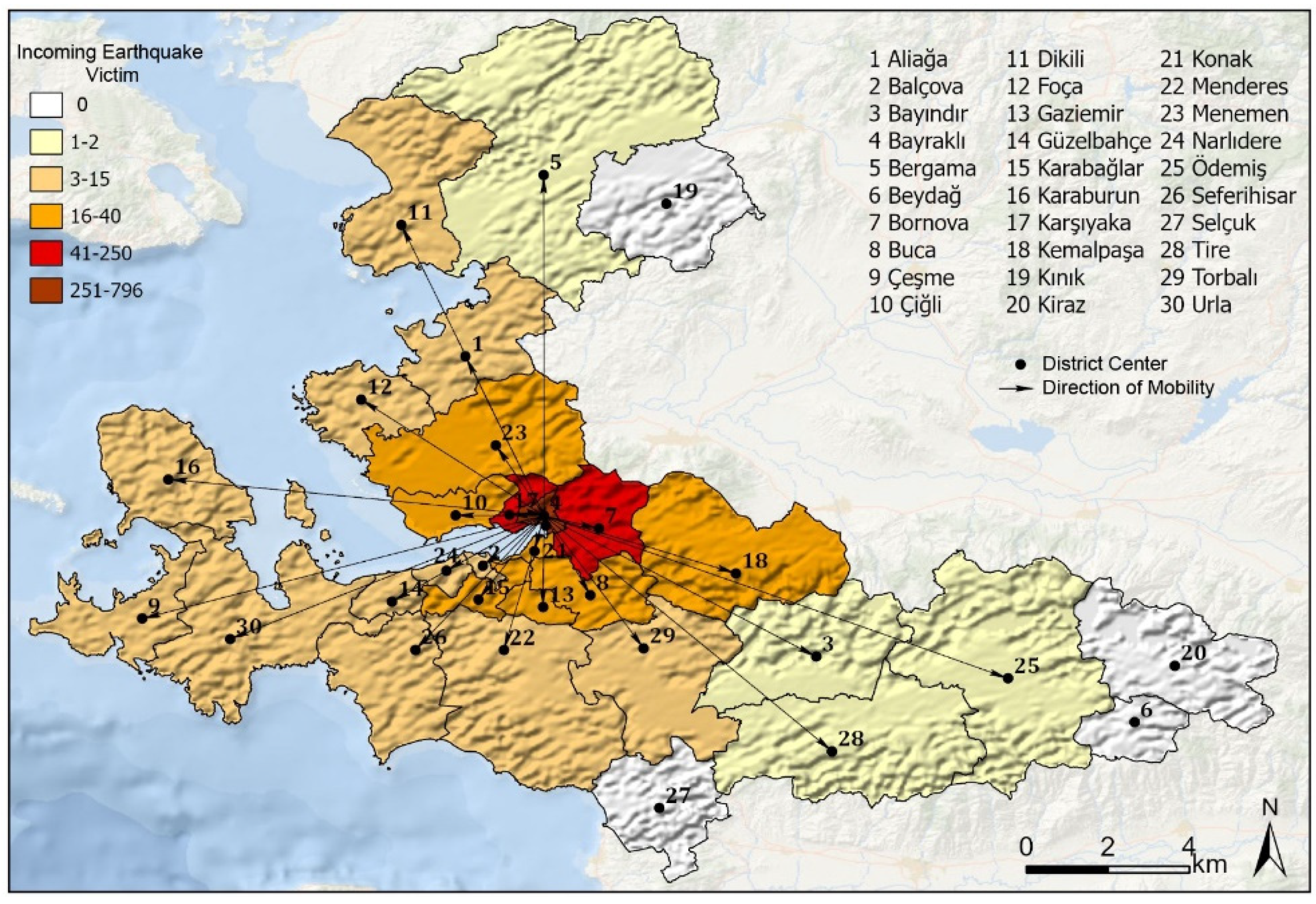
16] indicates that the worst-case scenario for disaster victims begins when the response to mitigate the effects of the disaster is weak. Therefore, carefully evaluating the criteria and outcomes of movements is important for managing the aftermath of the disaster. Short and long-distance movements after disasters are the current forms of response to disasters. At this stage, it is crucial to question which causalities lead to what type of migration movement. The first type of movement identified in this study is moving to nearby places. The tendency to move to nearby places is pronounced both at the district and neighbourhood levels. At the district level, Karşıyaka, Bornova, and Bayraklı are among the stops for those affected by the disaster. Conversely, there is a further concentration towards the outskirts, such as Menemen, Çiğli, Konak, Kemalpaşa, and Karabağlar districts. The third level of concentration, located quite on the outskirts, includes Aliağa, Foça, Torbalı, Menderes, Urla, and Çeşme; and finally, the outermost areas comprise Bergama, Bayındır, Ödemiş, and Tire districts. The number of individuals in these district groups decreases systematically from the inner to the outer areas (
Figure 2).
Varol et al. (2024) [
12] state that this situation stems from the perception among those affected by the earthquake that less damaged areas are safer. They further note that the preference for nearby districts was also influenced by the availability of second homes, such as summer houses. Similarly, this pattern also emerged in our study. However, our interviews revealed that, in addition to the ‘safe zone’ concept proposed by the authors, secondary causal factors—such as a sense of ownership of the city and socio-economic reasons—are also associated with the decision to remain nearby.
Moreover, it appears that the mobility pattern identified by the authors in the immediate aftermath of the earthquake remained valid even two years later. Ultimately, earthquake survivors do not show a strong tendency to leave İzmir despite the disaster. This finding is supported both at the neighbourhood and district levels. These movements should also be interpreted, in a broader sense, as a response to the temporary impacts of the disaster. The worst-case scenario described by Fernando et al. (2010) [
16] was not observed at this stage. Those affected by the disaster preferred to engage in reconstruction efforts in areas close to their former neighbourhoods. This also points to the strength of the tendency to return.
From an urban resilience perspective, this pattern suggests that post-disaster recovery is strongly shaped by proximity-based coping strategies rather than complete spatial rupture. The persistence of short-distance mobility reflects adaptive capacity within the existing urban structure, where individuals attempt to restore normalcy within familiar socio-spatial environments rather than relocating entirely.
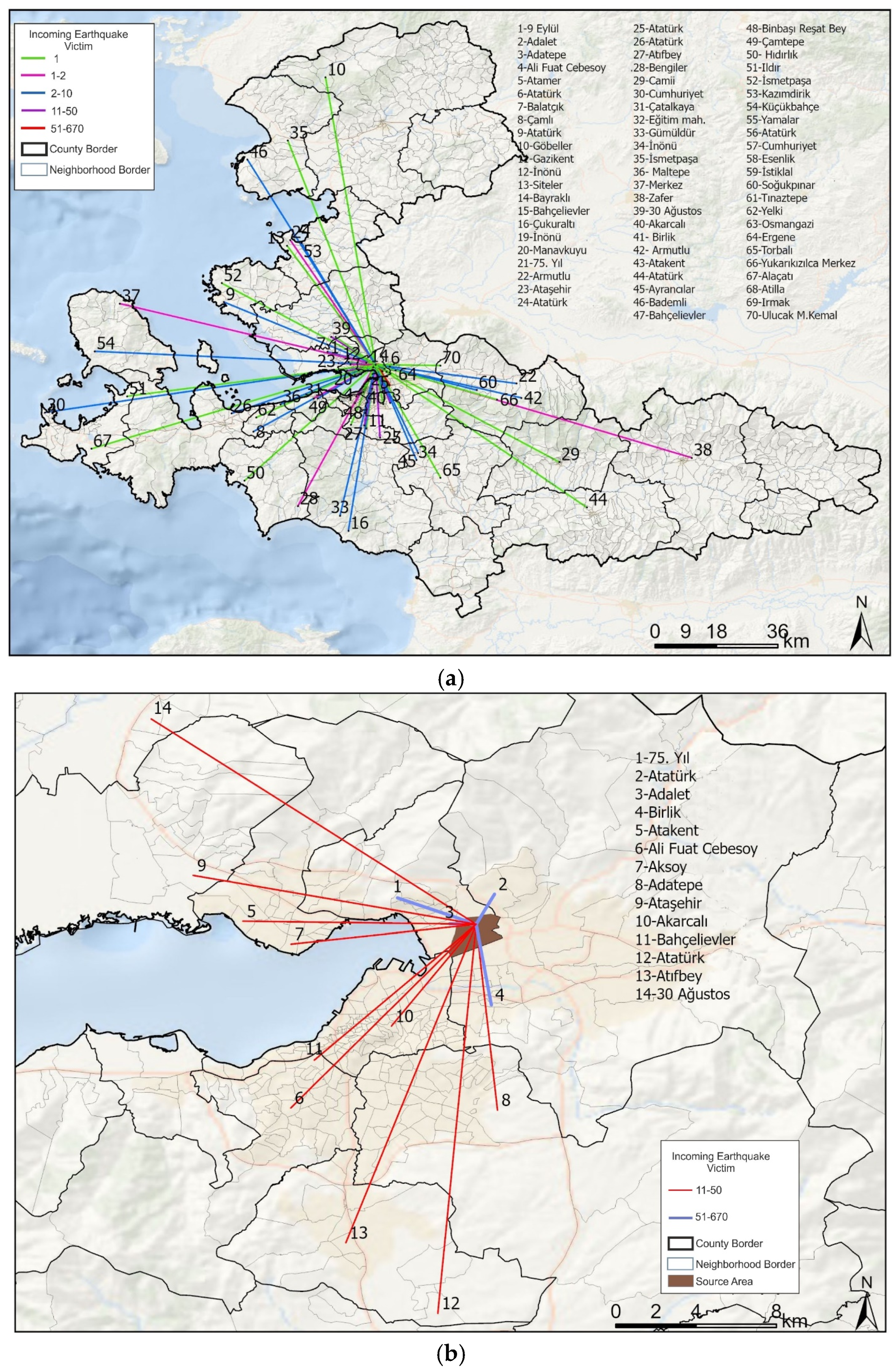
When examined at the neighbourhood level, a similar pattern of distribution to nearby districts is observed. At this stage, a noteworthy detail is the formation of distinct concentration areas in the districts where the density decreases from the second level to the fourth level (
Figure 3a,b). However, another remarkable detail in the distribution at the neighbourhood level is the high density in prominent neighbourhoods in the nearby districts that were most affected by the earthquake and even experienced the most destruction. This outcome is similar to the findings of Varol et al. (2024) [
12], where the areas relocated to had relatively low levels of damage but remained highly susceptible to seismic hazards. This is an important finding indicating that earthquake survivors tend to stay close rather than move away from neighbourhoods with high levels of destruction.
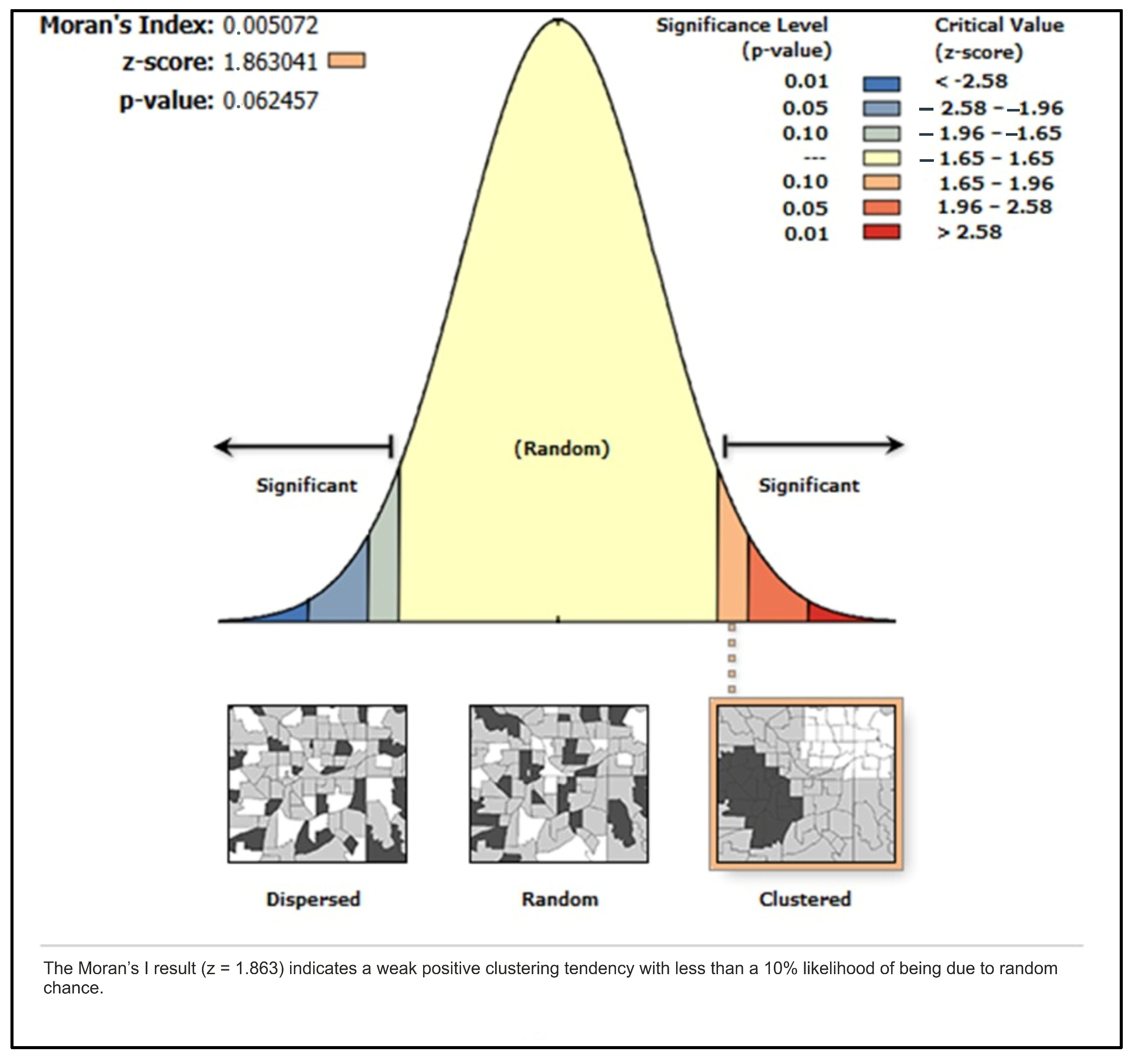
The results of the Moran’s I analysis indicate a weak positive spatial autocorrelation in residential mobility patterns across İzmir (
Figure 4). The obtained z-score of 1.863 and
p-value of 0.06 suggest that the global spatial pattern is not statistically significant at the 95% confidence level, although it indicates a marginal clustering tendency at the 90% confidence level (α = 0.10). This result implies that residential mobility is not randomly distributed across space, but rather exhibits a weak tendency toward spatial dependence at the city scale.
In contrast, the local spatial clustering results (high–low clustering) show statistically significant patterns, with a z-score of 3.257 and p-value of 0.001. This indicates the presence of localized hotspots where residential mobility is significantly more concentrated compared to surrounding areas. These findings suggest that while global spatial dependence is weak, mobility patterns become more pronounced and structured at the local scale, highlighting the importance of multi-scale spatial interpretation.
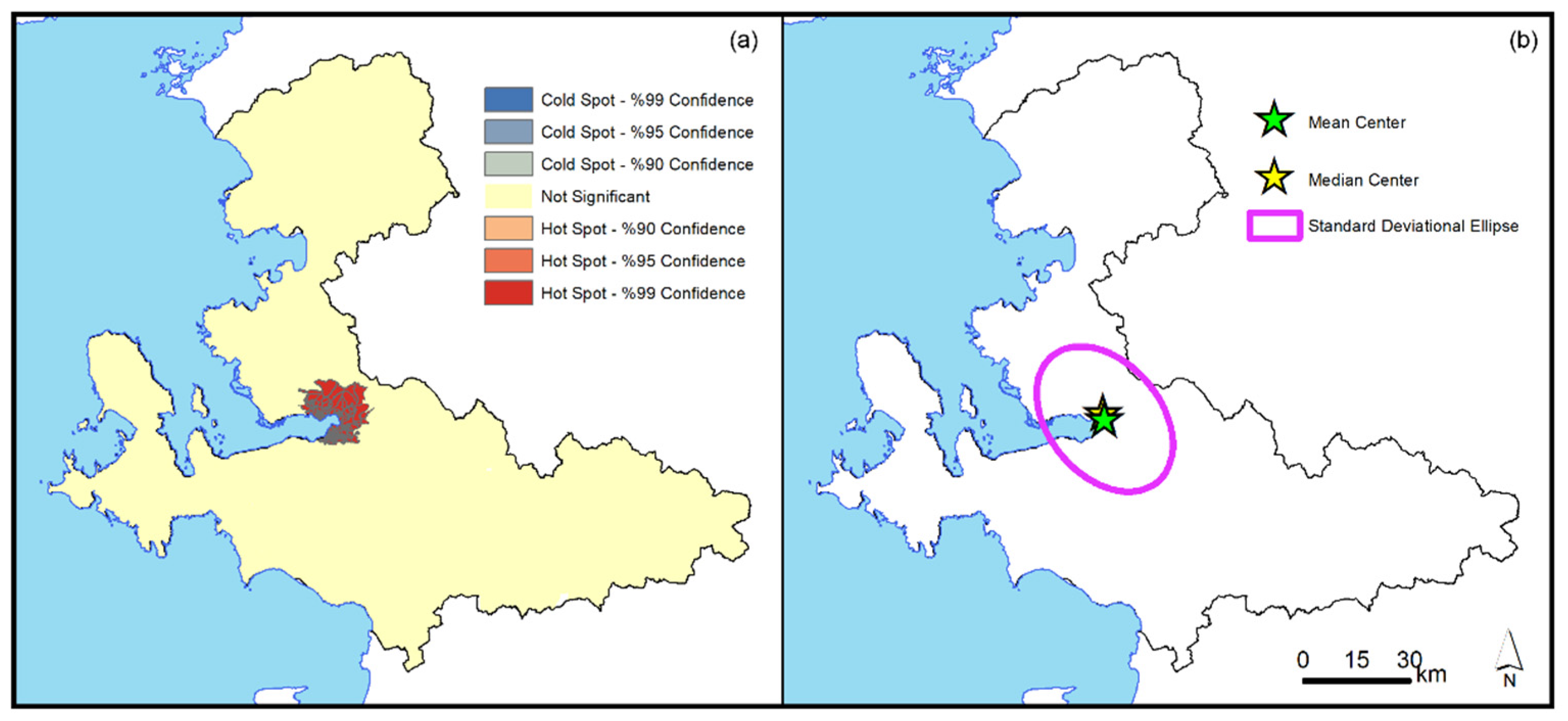
Centroid and median centroid measures further support this multi-scalar interpretation by illustrating the central tendency of mobility flows (
Figure 5a,b). Although both indicators are located in proximity to the eastern part of the bay—where earthquake impacts were most severe—they do not represent the full spatial distribution of movements, but rather summarize overall directional tendencies. The standard deviation ellipse further demonstrates the degree of spatial concentration and directional orientation of movements, indicating a pronounced northwest–southeast axis of mobility.
The directional distribution results also show that mobility is spatially concentrated in a relatively narrow corridor extending around the most affected neighbourhoods. Rather than being interpreted solely as a simple relocation response, this pattern may reflect a combination of constrained mobility, housing availability, and partial place attachment effects. While displacement away from the disaster zone can be understood as an adaptive response to reduce risk exposure [
16], continued residence or short-distance relocation within affected areas may also indicate forms of immobility shaped by socio-spatial constraints and attachment to place [
10].
4.2. Experiences After the Earthquake: Coping Mechanisms and Issues
Average centroid and the sudden destruction in settlements forces those affected by the earthquake to take certain precautions. One of these necessities is the establishment of emergency shelters. In an effective and efficient disaster management structure, emergency and temporary shelters are designated at specific points in urban and rural areas. Depending on seasonal conditions, those affected by the disaster initially prefer these areas as shelter. However, in cases where pre-planning is neglected, spontaneous shelters may emerge. The emergence of temporary shelters [
46] spontaneously formed by earthquake survivors in İzmir after the earthquake demonstrates the neglect of planning efforts in a city with high seismic risk. Additionally, statements such as Hatice (F, A:54, G:Primary School) “
My brother’s house was somewhat intact. We used to go there at two in the night and sleep there, then get up at 6 am and leave. Even though it’s my brother’s place, it’s still someone else’s house. Everyone has their own routine there. Theirs was intact unlike ours” or Zeynep’s (F, A:49, G:Primary School) “
We had to stay at my brother’s house. But I had a lot of trouble. Why was I so upset? Because my brother also went through very difficult times because of me” can be cited as examples of this. Although going to family members’ homes immediately after the İzmir earthquake may seem like an effective solution in the short term, it leads to increased tension in the medium term. Although there is no trend that can be generalized to all interviewees, the negative aspects of going to family members’ homes should be considered. These qualitative narratives are broadly consistent with the spatial mobility findings presented in the previous section, particularly the tendency toward short-distance and intra-urban relocation patterns concentrated around the most affected neighbourhoods. The spatial clustering of mobility suggests that many earthquake survivors attempted to remain within familiar socio-spatial environments despite the disruption caused by the disaster.
This coping pattern may reflect some limitations of informal resilience mechanisms in post-disaster contexts. While family-based sheltering provides immediate relief, it simultaneously reveals the absence of structured emergency housing systems, highlighting the uneven distribution of resilience capacities across institutional and household levels.
Another indicator of spontaneous and unplanned movement in temporary shelters is evident in the preference for places such as hotels, empty spaces, vehicles, or friends’ houses. Such a tendency often arises as a choice in the absence of alternatives. The lack of planning, as mentioned above, may contribute to this sense of helplessness.
The second stage in the housing situation after the earthquake corresponds to the efforts of those whose living spaces have been destroyed to find accommodation. Quarantelli (1995) [
46] places this stage as the third stage of reconstruction, labelled as “temporary housing”. In this stage, there is a tendency to shift from the previous stage’s helplessness to more sustainable solutions. This stage also corresponds to the period just before acquiring permanent housing. Those affected by the disaster are inclined to continue their daily routines, considering the possibility of prolonging the process of obtaining temporary housing. However, in developing countries like Turkey, there are significant obstacles specific to the acquisition of temporary housing. Foremost among these is the housing stock. According to interview narratives, one of the most visible post-earthquake trends was the sharp increase in housing sales and rental prices. After the İzmir Earthquake, there were sudden upward fluctuations in rental prices in some neighbourhoods of the city. The majority of interviewees affected by the earthquake consider the inability to find temporary housing as one of the most important problems they faced after the earthquake. The difficulty/delay in acquiring temporary housing raises questions about the actors involved in this situation among the disaster victims. In the initial stages of evaluation, individuals’ “opportunistic” attitudes and evaluations play a significant role in such a result. Public roles such as regulating rental prices and preventing sudden increases through various inspections are considered secondary. Many interviewees perceived sudden rent increases as being associated with opportunistic individual behaviour during the post-earthquake period. “
Rents didn’t increase, they soared. In the meantime, as I said, there were some houses in Uzundere that the municipality allocated for the earthquake victims to stay temporarily, but isn’t it something related to these institutions? Unfortunately, I will always mention this as a footnote. It stems from our people. Under normal circumstances. They give you a box, thinking that it fills your stomach, the matter ends. But the biggest problem is housing, look at the rent that is 2000 TL (€80). The earthquake happened the next day, or on the thirtieth of October. We could only get ourselves together in a day or two. They directly doubled the rents and put people in queues, don’t they like someone? You’re a student, there’s no place for you. You’re a civil servant, come here they discriminate like this” (Ahmet, M, A:40, G:Bachelor’s degree).
These qualitative findings are also supported by housing market indicators. Endeksa-based data for İzmir, particularly in districts such as Bayraklı, show a strong upward trend in rental prices per square metre in the post-2020 period. For instance, average rental prices increased from approximately 17 TL/m
2 in January 2021 to around 25 TL/m
2 in January 2022, followed by a continued upward trajectory reaching substantially higher levels in the subsequent years. Overall, the cumulative increase between 2021 and 2026 indicates a sharp escalation in rental values [
47]. However, these figures should be interpreted with caution, as this increase is likely shaped not only by post-earthquake housing pressures but also by broader macroeconomic conditions in Türkiye, particularly high inflationary dynamics. The integration of interview narratives with housing market indicators also demonstrates how post-disaster mobility cannot be understood solely through spatial movement patterns. Instead, relocation decisions were strongly shaped by housing affordability, access constraints, and perceived economic insecurity during the recovery process.
4.3. Are We Creating Problems or Providing Solutions? The Earthquake Test of Institutional Structure
The second theme that emerged in the scope of the study is related to the institutional structure. The actors under the institutional structure are quite diverse. The categories under the institutional structure theme are dissatisfaction, actors, aid, satisfaction, and social media. Narratives under the institutional structure primarily concentrate under the dissatisfaction category, where codes such as lack of information and process management converge. Regulations, unpreparedness, indifference, obligation, delay, and being moderately damaged are micro sources of dissatisfaction. The actors under the institutional structure are quite diverse. The İzmir Metropolitan Municipality, AFAD (Disaster and Emergency Management Presidency), İZDEDA, Turkish Red Crescent, Ministry of Environment, Urbanisation and Climate Change, Natural Disaster Insurance Institution (DASK), political parties, non-governmental organizations, and the Turkish Police Force are identified as the actors governing the institutional structure. Regarding the relationship of aid with the mentioned institutions, issues of quantification, insufficient and adequate distribution arise, while the presence of the state is shown as the sole source of satisfaction. Lastly, social media narratives under the institutional structure consist of three codes: WhatsApp, Facebook, and Twitter.
The active intervention of the state in disasters is most evident in the issue of resettling those most affected by the disaster. Badri et al. (2006) [
9] argue that ineffective management of resettlement processes in the 11 years following the 1990 Manjil Earthquake (Iran) resulted in negative outcomes in employment, income loss, female employment, and lifestyle. The effects of the earthquake that occurred in the Aegean Sea in 2020, have a close connection with institutions in İzmir. This connection can be summarized under two headings: lack of information and process management. Interview narratives suggest that one of the primary sources of dissatisfaction regarding information processes was the perceived unpreparedness of state institutions at both upper and lower scales. The allocation of the majority of earthquake preparedness efforts to essential activities such as search and rescue results in the neglect of post-earthquake reconstruction processes. The analysis suggests that perceived indifference emerged as one of the factors associated with dissatisfaction regarding institutional response processes. In support of this, the analysis shows that indifference overlaps with delay, municipal issues, rent increases, aid amounts, and insufficient aid. Therefore, many participants associated institutional dissatisfaction with perceived indifference, delays, and insufficient communication during the post-earthquake process.
These institutional narratives also help contextualize the spatial mobility patterns identified in the quantitative analysis. In particular, delays, uncertainty, and perceived inadequacies in institutional response may have contributed to the concentration of mobility within limited urban corridors rather than facilitating broader relocation alternatives.
From a spatial governance perspective, these findings indicate that post-disaster recovery is not only a technical or administrative process but also a politically and socially constructed field. The perceived inefficiencies in institutional response may highlight the importance of governance capacity in shaping both material recovery and public trust, which are essential components of resilient urban systems. Similar findings have also been discussed in recent post-disaster recovery studies focusing on participatory governance and territorial resilience. For example, Córdoba Hernández et al. (2025) [
48], in their analysis of the 2021 La Palma volcanic eruption in Spain, emphasize that citizen participation and inclusive governance mechanisms play a critical role in strengthening urban resilience and reducing vulnerabilities during reconstruction processes.
4.4. The Societal, Economic, and Health Impact of the Earthquake
From the initial moments of the earthquake to the aftermath, those affected continue their struggle. Particularly noteworthy is the deepening of psychological effects when physical destruction is extensive. Such a psychological effect is reflected in the increase in anxiety levels. When the causes of anxiety are questioned, the devastation left by the earthquake becomes better understood. Many participants described prolonged feelings of anxiety, insecurity, and fear following the earthquake. The interviews conducted as part of the study suggest that one of the most significant effects of the earthquake, which is burn-out, is associated with psychological support, as those affected by the earthquake try to overcome it with the help of a doctor. However, those who have stronger resilience or prefer to cope through family and neighbourhood relationships tend to choose not to seek psychological support.
“We didn’t experience or expect any adaptation problem. We mostly had psychological troubles. As I said, we felt like we hit rock bottom”.
(Belgin, F, A:43, G:Bachelor’s degree)
Another important outcome conveyed regarding natural disasters is the negative change in economic status [
24,
25,
26]. Both at the local and macro levels, earthquakes can generate adverse effects on economic conditions. The economic impact of an earthquake may be influenced by the effectiveness of institutional intervention. The comparative economic analysis conducted by Diaz et al. (2024) [
26] on New Zealand and Chile highlights the consequences of inadequate earthquake management in Chile through three main points: the earthquake-related expenditures made by the state, the lack of institutional quality, and the slow and ineffective recovery process. Accordingly, the absence or insufficiency of state intervention can lead to a more profound experience of the earthquake’s economic consequences.
In İzmir, the changes in economic indicators after the earthquake manifested themselves not as a major economic loss but rather as cost increases in certain items described as additional expenses. These items commonly include housing, transportation, transportation fees, and household items. Interview narratives suggest that these additional expenses did not always result in direct large-scale economic losses, but they nevertheless created significant financial pressure for many households. However, these cost items, which appear to be developed due to the earthquake, become burdensome for individuals when they exceed their current economic income. The other two notable expenses in terms of additional expenses are housing and transportation fees. Transportation fees are an important expenditure source for individuals living in peripheral areas but maintaining connections with the city for work. It should be carefully noted here that the emergence of transportation as a cost item is due to the use of multiple transportation vehicles when moving from the periphery to the centre.
Another fracture observed in the societal structure after the earthquake is related to kinship and neighbourhood relationships. At this stage, neighbourhood relationships emerge as the most highlighted effect by the interviewees. Changes in neighbourhood relationships before and after the earthquake progress on two main axes. However, the point where the narratives intersect is related to the change trajectory of neighbourhood ties established before the earthquake. At this stage, it is challenging to make a definitive determination about the change trajectory of neighbourhood relationships. Personal stories experienced by earthquake survivors often play a supportive role in shaping positive or negative situations in neighbourhood relationships. Another point where narratives about neighbourhood relationships are concentrated is related to experiences during the adaptation process to the new residence and neighbourhood. Therefore, some interviewees make observations that distinguish their experiences in the new place from the previous one. However, it should also be emphasized that there is not a significant difference in the narratives. For example, participant Ali (M, A:51, G:Master’s degree) mentions that due to the crowded nature of the relationships with neighbours in the residence where he lived before the earthquake, they remained at the level of saying “hello” only.
These changes may also be interpreted through the lens of spatial justice, as social and economic disruptions are not evenly distributed across different household groups. Variations in coping capacity, income stability, and housing security contribute to differentiated recovery trajectories, reinforcing existing socio-spatial inequalities in the post-disaster urban environment. Taken together, the qualitative findings complement the spatial analysis by illustrating that residential mobility after the earthquake was shaped not only by physical displacement, but also by socio-economic vulnerability, institutional capacity, and uneven access to recovery resources.
4.5. Limitations
This study has several limitations that should be acknowledged. First, the qualitative interviews were conducted approximately three years after the 2020 Aegean Sea Earthquake. Therefore, participants’ recollections of immediate post-disaster experiences and early mobility decisions may have been affected by recall bias. Retrospective narratives may involve selective memory and post hoc reinterpretations of events. However, the primary aim of the study was to examine longer-term residential mobility trajectories, recovery experiences, institutional interactions, and evolving perceptions of safety rather than the precise reconstruction of short-term behavioural responses.
Second, the study relied partly on individuals connected to the İzmir Earthquake Victims Solidarity Association (İZDEDA). As a result, the dataset may not fully represent the entire earthquake-affected population of İzmir and may overrepresent individuals who experienced stronger housing-related grievances, displacement experiences, or institutional dissatisfaction. Similarly, the use of snowball sampling may have introduced network-related sampling bias despite efforts to ensure diversity in socio-economic backgrounds, tenure status, and mobility experiences among participants. Finally, the findings are based on a single-case study of the 2020 Aegean Sea Earthquake in İzmir. Therefore, the observed residential mobility patterns primarily reflect intra-urban displacement dynamics. In disaster contexts involving large-scale out-migration, cross-regional relocation, or different socio-economic conditions, mobility decisions may be shaped by additional factors such as labour market opportunities, regional inequality, and long-term migration strategies. Accordingly, the findings should be interpreted cautiously and understood as reflecting observable mobility patterns within the available case rather than universally generalizable conclusions. As a result, caution is required when generalizing the findings to different geographical and disaster contexts.
5. Conclusions
This study has addressed the post-earthquake process on two main axes. The first is the mobility of those affected by earthquakes, which can be exemplified as sudden natural disasters. The primary approach here is to reveal the trajectory of movements and the causality within this trajectory. The second critical point within the scope of the study is the experiences following the earthquake. The disruptive effect of the earthquake on daily life and the subsequent events have been revealed through qualitative research-based processes.
Earthquake survivors generally preferred to remain in nearby neighbourhoods and districts in order to maintain their social, spatial, and economic ties with the city. While previous studies such as Varol et al. (2024) have emphasized the perception of safer areas and the availability of secondary housing as key determinants of mobility [
12], this study further demonstrates that place attachment, socio-economic constraints, and housing affordability also play a significant role in shaping post-disaster residential decisions. The findings additionally show that mobility trajectories were not stable over time and could change depending on institutional intervention, housing conditions, and economic pressures [
12].
Beyond its empirical findings, the study contributes to the broader literature on post-disaster mobility by demonstrating that residential recovery should be understood as a dynamic socio-spatial process rather than a temporary emergency response. The İzmir case highlights how mobility decisions are closely linked to urban resilience, institutional capacity, and spatial inequalities. In particular, the persistence of short-distance displacement patterns indicates that post-disaster recovery is strongly shaped by existing urban networks and socio-spatial attachments. By focusing on a Mediterranean urban context that remains underrepresented in the international literature, the study contributes to contemporary debates on post-disaster governance, spatial justice, and uneven recovery processes.
This research focuses on the societal and spatial dimensions of the earthquake, providing a perspective on the socio-economic changes caused by sudden natural disasters in individuals’ lives. The results of the study, in line with previous research, emphasize the effects of the earthquake on health and economic impacts [
24,
25,
26,
28]. Particularly, changes in economic status can result in consequences such as loss of function in settlements and decreases in individuals’ economic levels. The economic impact of the earthquake, beyond the loss of function throughout the city, manifests itself in additional costs in various items such as moving and transportation for households. This situation not only raises the discussion of the destructiveness of the earthquake but also highlights İzmir’s unique position compared to other examples, as a devastating earthquake that could affect the entire settlement did not occur.
From a policy perspective, the findings emphasize the importance of strengthening post-disaster housing strategies, improving institutional coordination, and developing more inclusive urban recovery policies. Temporary housing provision, rental market regulation, and long-term psychosocial support mechanisms appear as essential components of resilient urban recovery processes. At the same time, the study suggests that recovery policies should not focus solely on physical reconstruction but should also address the socio-economic vulnerabilities that shape uneven recovery trajectories among different social groups.
Finally, several limitations should be acknowledged. The qualitative component of the study is based on a relatively limited sample and partly relies on retrospective narratives collected approximately three years after the earthquake, which may introduce recall bias. In addition, the use of participants connected to İZDEDA may not fully represent the broader earthquake-affected population in İzmir. Future studies could therefore benefit from larger comparative datasets and longitudinal approaches examining post-disaster mobility trajectories across different regional and socio-economic contexts [
8,
29,
32].




 ,
,