


Thermal Regime Characteristics of Alpine Springs in the Marginal Periglacial Environment of the Southern Carpathians

 ,
, 
 and
and
Abstract
1. Introduction
2. Materials and Methods
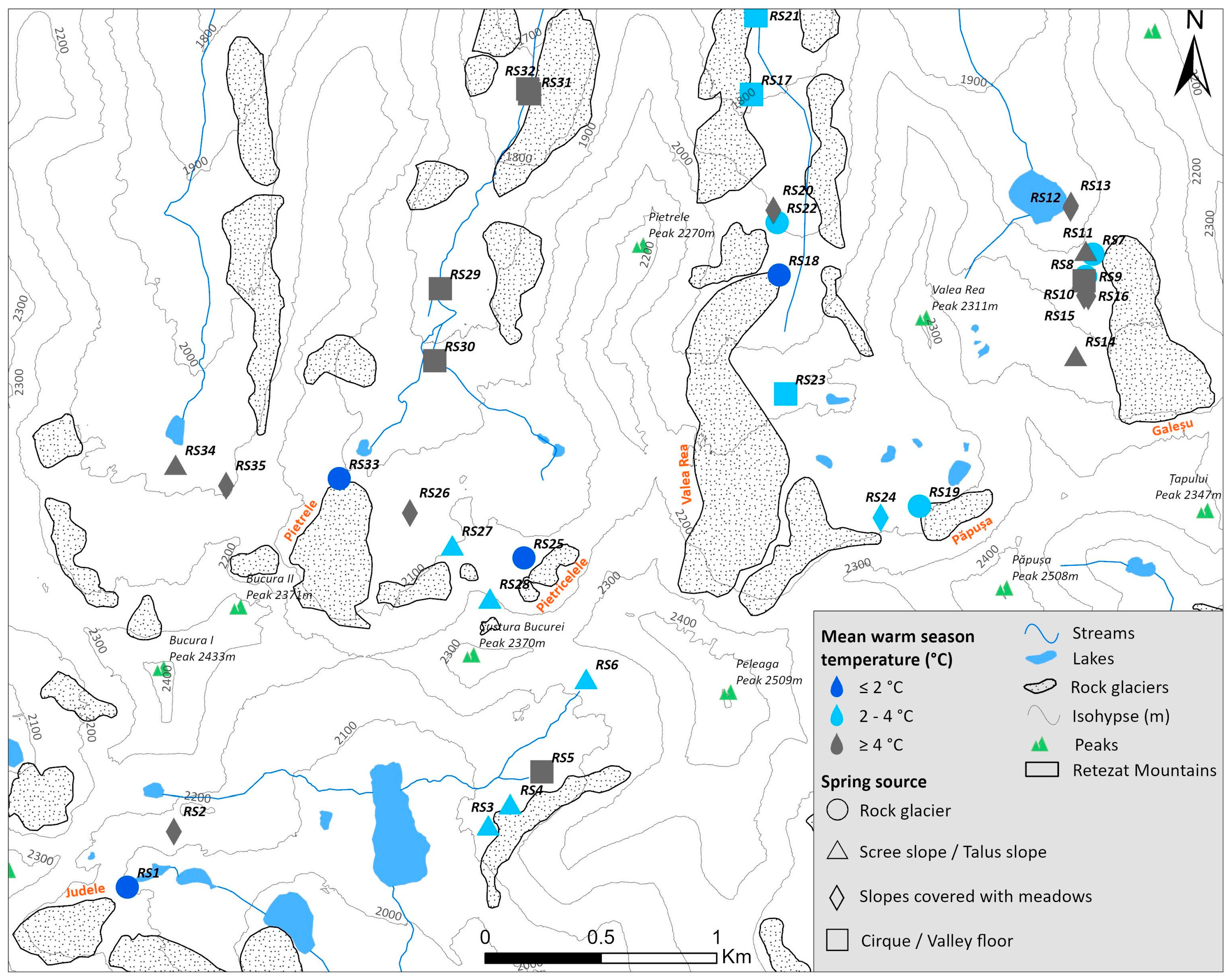
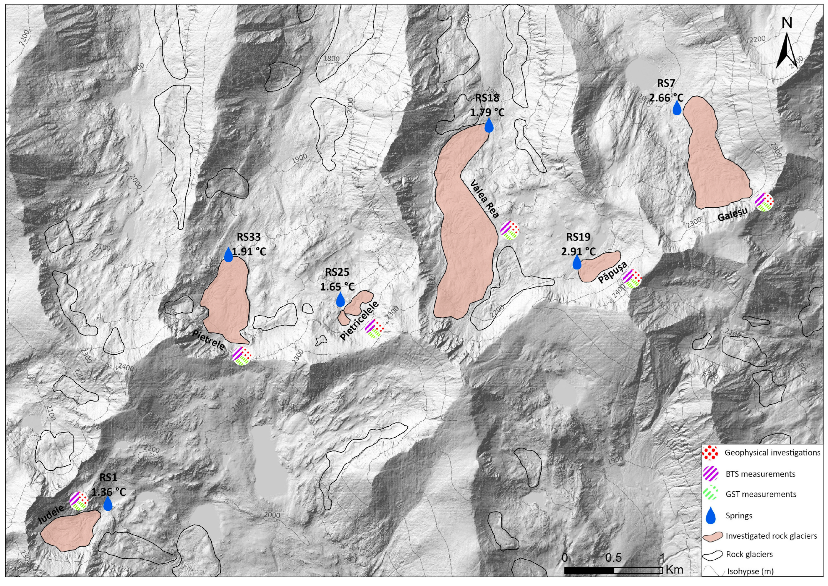
2.1. Study Area
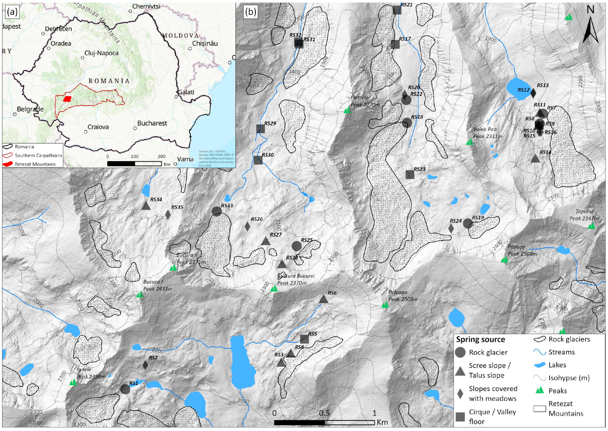
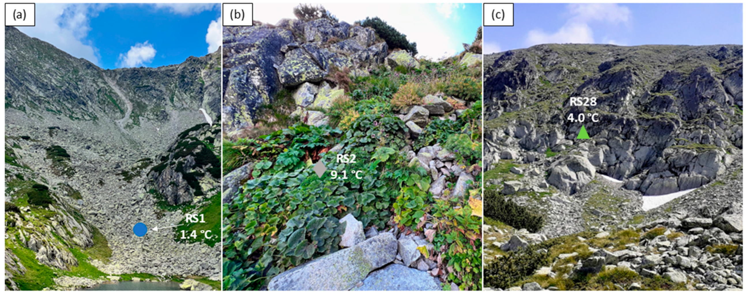
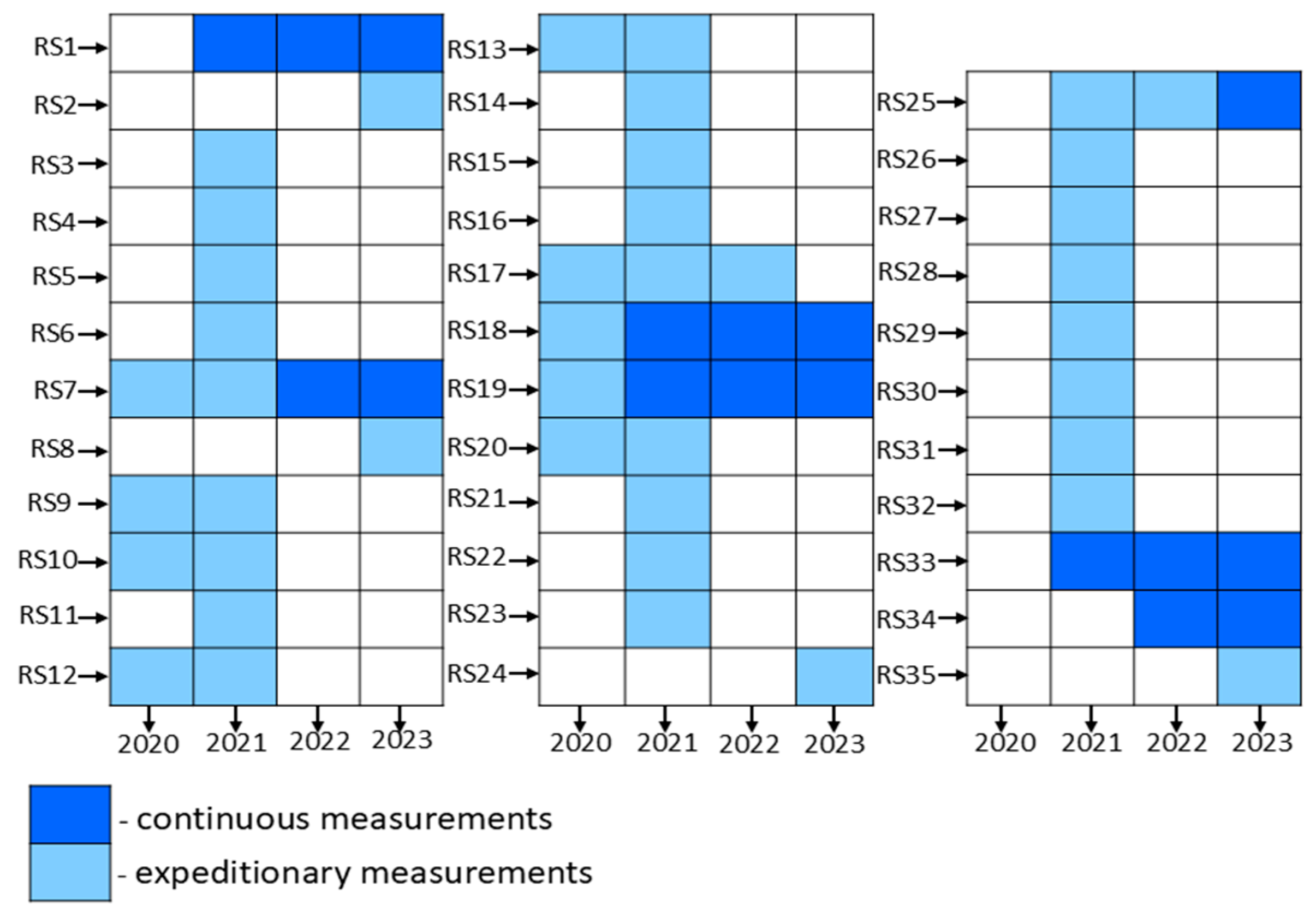
2.2. Field Activities
2.3. Data Analysis
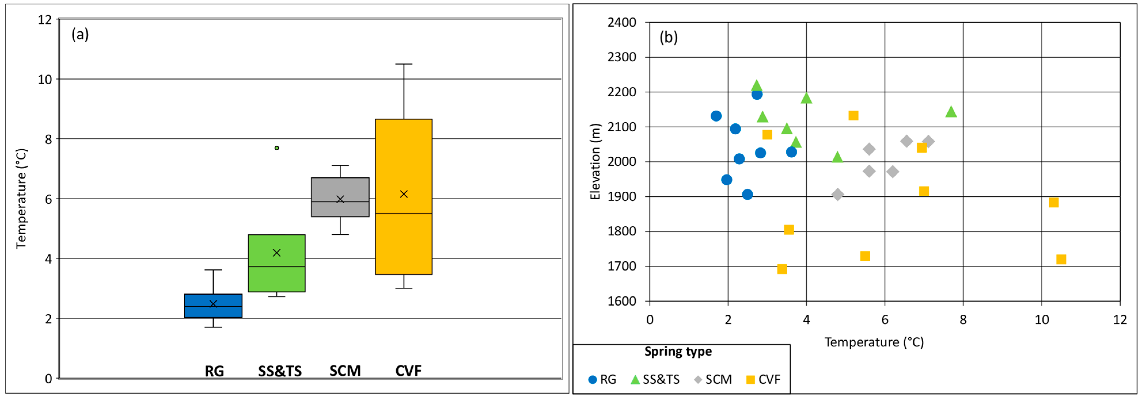
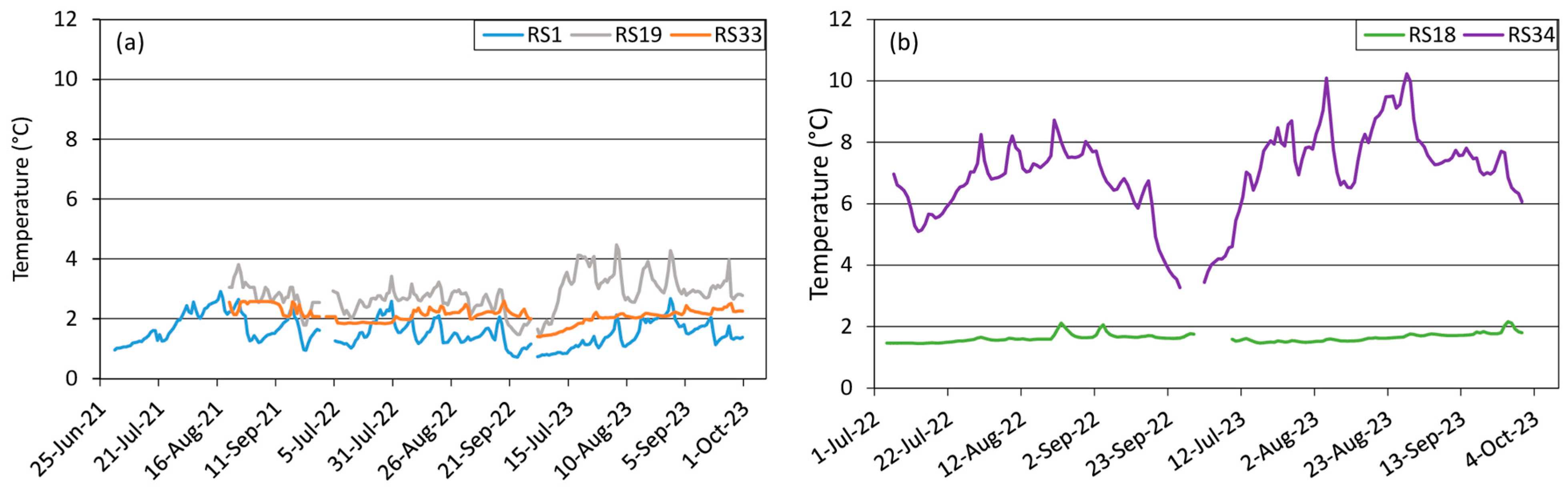
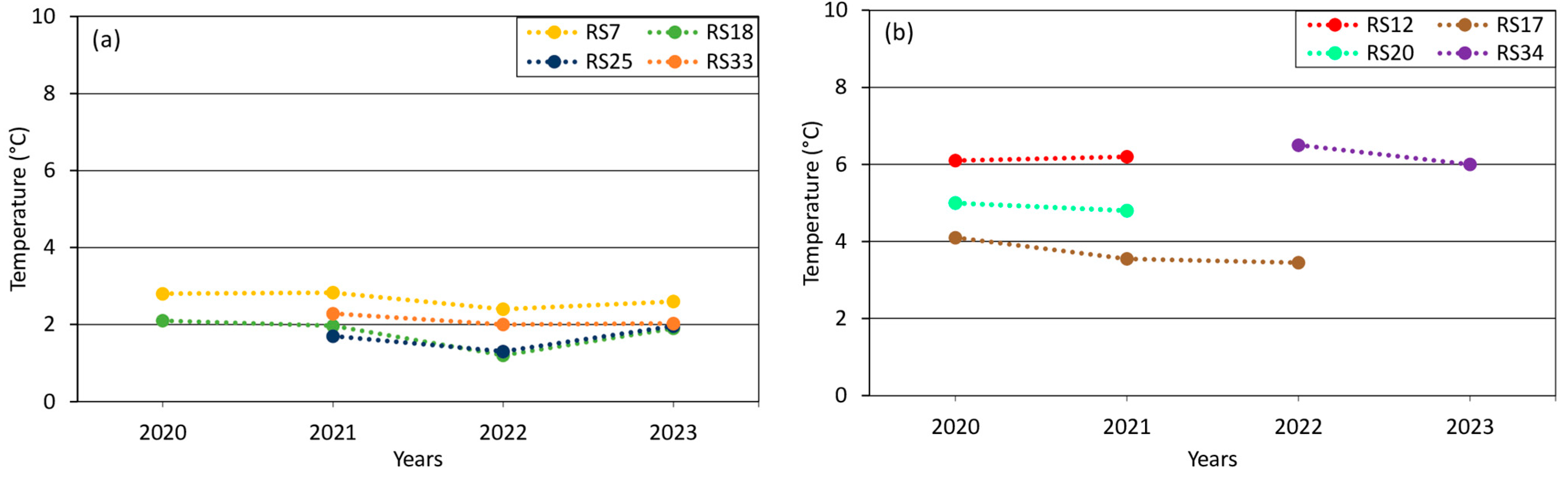
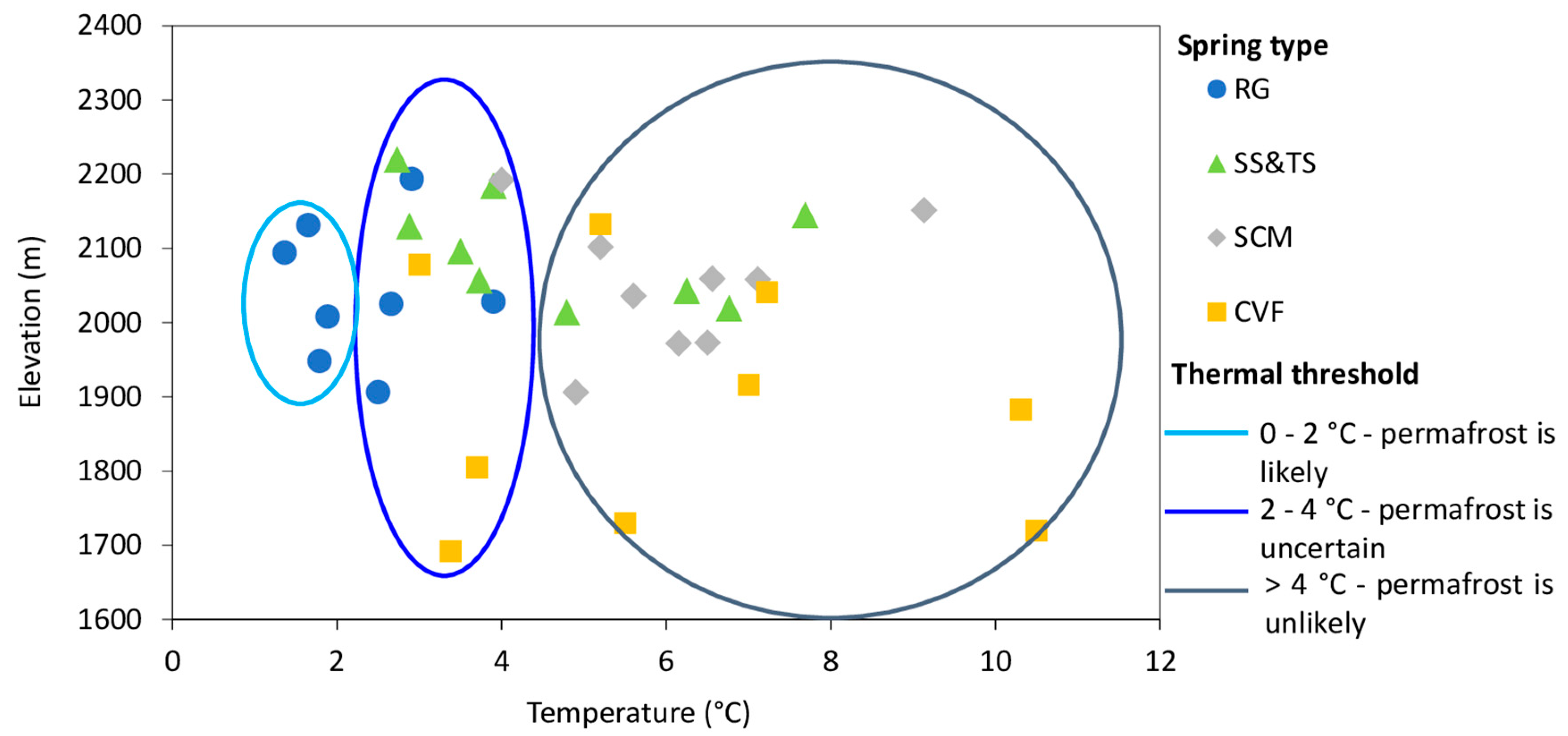
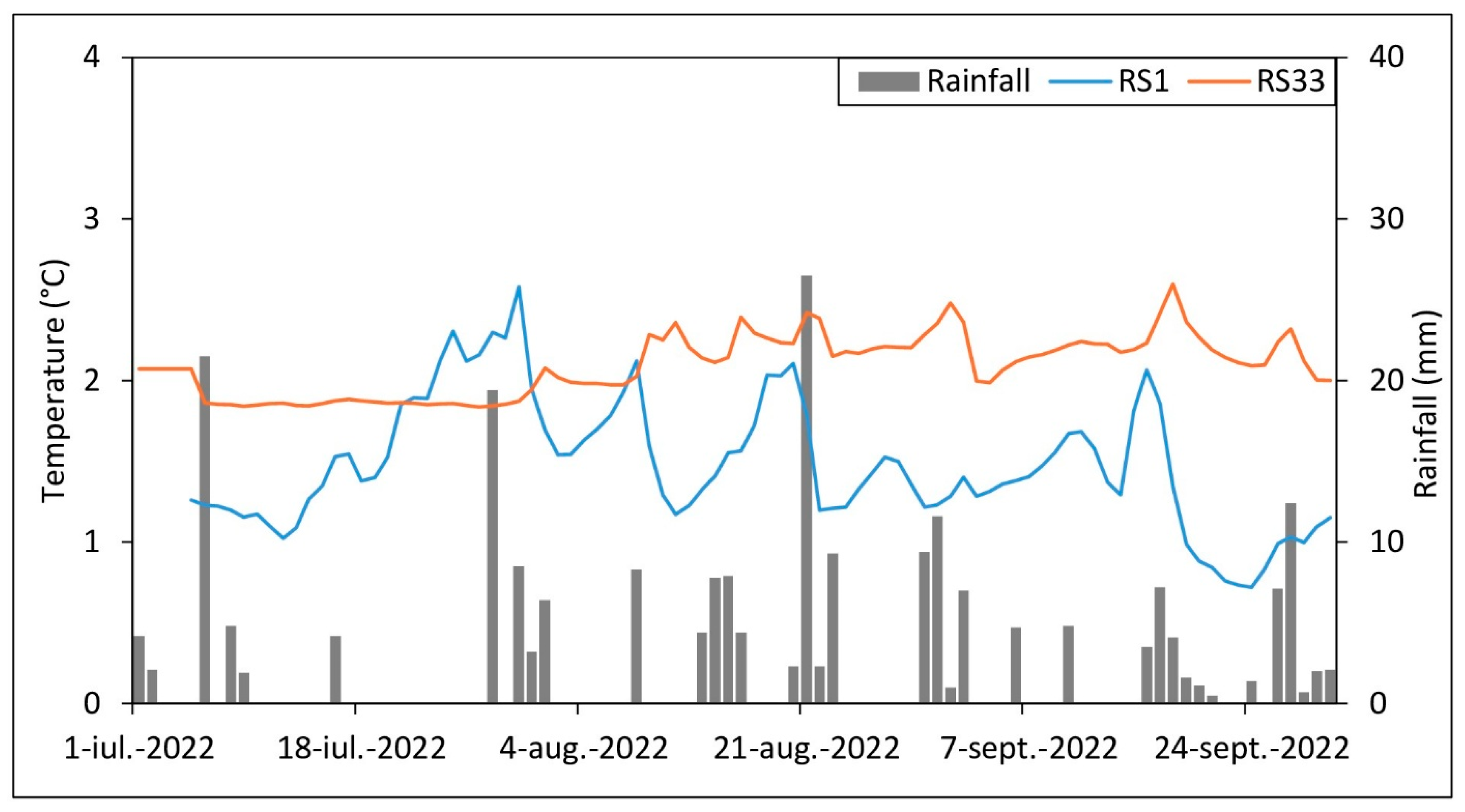
3. Results
4. Discussion
5. Conclusions
Author Contributions
Funding
Institutional Review Board Statement
Informed Consent Statement
Data Availability Statement
Acknowledgments
Conflicts of Interest
Abbreviations
| RG | rock glaciers |
| SS&TS | scree slopes and talus slopes |
| SCM | meadow-covered slopes |
| CVF | cirque/valley floors |
| BTS | temperature at the bottom of the snow cover |
| GST | ground surface temperature |
References
- Messerli, B.; Viviroli, D.; Weingartner, R. Mountains of the world: Vulnerable water towers for the 21st century. Ambio 2004, 33, 29–34. [Google Scholar] [CrossRef]
- Viviroli, D.; Dürr, H.H.; Messerli, B.; Meybeck, M.; Weingartner, R. Mountains of the world, water towers for humanity: Typlogoy, mapping, and global significance. Water Resour. Res. 2007, 43, 1–13. [Google Scholar] [CrossRef]
- Hock, R.; Rasul, G.; Adler, C.; Cáceres, B.; Gruber, S.; Hirabayashi, Y.; Jackson, M.; Kääb, A.; Kang, S.; Kutuzov, S.; et al. High Mountain Areas. In IPCC Special Report on the Ocean and Cryosphere in a Changing Climate; Pörtner, H.-O., Roberts, D.C., Masson-Delmotte, V., Zhai, P., Tignor, M., Poloczanska, E., Mintenbeck, K., Alegría, A., Nicolai, M., Okem, A., et al., Eds.; Cambridge University Press: Cambridge, UK; New York, NY, USA, 2019; pp. 131–202. [Google Scholar] [CrossRef]
- Huss, M.; Bookhagen, B.; Huggel, C.; Jacobsen, D.; Bradley, R.; Clague, J.; Vuille, M.; Buytaert, W.; Cayan, D.; Greenwood, G.; et al. Toward mountains without permanent snow and ice. Earth’s Future 2017, 5, 418–435. [Google Scholar] [CrossRef]
- IPCC Climate Change. The Physical Science Basis. In Contribution of Working Group I to the Sixth Assessment Report of the Intergovernmental Panel on Climate Change; Masson-Delmotte, V., Zhai, P., Pirani, A., Connors, S.L., Chen, Y., Goldfarb, L., Gomis, M.I., Matthews, J.B.R., Berger, S., Huang, M., et al., Eds.; IPCC: Geneva, Switzerland, 2021; Available online: https://www.ipcc.ch/report/ar6/wg1/downloads/report/IPCC_AR6_WGI_SummaryVolume.pdf (accessed on 10 March 2025).
- Jones, D.B.; Harrison, S.; Anderson, K.; Whalley, W.B. Rock glaciers and mountain hydrology: A review. Earth-Sci. Rev. 2019, 193, 66–90. [Google Scholar] [CrossRef]
- Wagner, T.; Kainz, S.; Helfricht, K.; Fischer, A.; Avian, M.; Krainer, K.; Winkler, G. Assessment of liquid and solid water storage in rock glaciers versus glacier ice in the Austrian Alps. Sci. Total Environ. 2021, 800, 149593. [Google Scholar] [CrossRef] [PubMed]
- Jones, D.B.; Harrison, S.; Anderson, K.; Betts, R.A. Mountain rock glaciers contain globally significant water stores. Sci. Rep. 2018, 8, 2834. [Google Scholar] [CrossRef]
- Biskaborn, B.K.; Smith, S.L.; Noetzli, J.; Matthes, H.; Vieira, G.; Streletskiy, D.A.; Schoeneich, P.; Romanovsky, V.E.; Lewkowicz, A.G.; Abramov, A.; et al. Permafrost is warming at a global scale. Nat. Commun. 2019, 10, 264. [Google Scholar] [CrossRef]
- Haeberli, W.; Schaub, Y.; Huggel, C. Increasing risks related to landslides from degrading permafrost into new lakes in deglaciating mountain ranges. Geomorphology 2017, 293, 405–417. [Google Scholar] [CrossRef]
- Ilyashuk, B.P.; Ilyashuk, E.A.; Psenner, R.; Tessadri, R.; Koinig, K.A. Rock glaciers in crystalline catchments: Hidden permafrost-related threats to alpine headwater lakes. Glob. Change Biol. 2018, 24, 1548–1562. [Google Scholar] [CrossRef]
- Beniston, M. Climatic change in mountain regions: A review of possible impacts. Clim. Chang. 2003, 59, 5–31. [Google Scholar] [CrossRef]
- Bodin, X.; Schoeneich, P.; Deline, P.; Ravanel, L.; Magnin, F.; Krysiecki, J.-M.; Echelard, T. Mountain permafrost and associated geomorphological processes: Recent changes in the French Alps. J. Alp. Res. 2015, 103, 2. [Google Scholar] [CrossRef]
- Carturan, L.; Zuecco, G.; Seppi, R.; Zanoner, T.; Borga, M.; Carton, A.; Dalla Fontana, G. Catchment-Scale Permafrost Mapping using Spring Water Characteristics. Permafr. Periglac. Process. 2016, 27, 253–270. [Google Scholar] [CrossRef]
- Krainer, K.; Mostler, W. Hydrology of active rock glaciers: Examples from the Austrian Alps. Arct. Antarct. Alp. Res. 2002, 34, 142–149. [Google Scholar] [CrossRef]
- Berger, J.; Krainer, K.; Mostler, W. Dynamics of an active rock glacier (Ötztal Alps, Austria). Quat. Res. 2004, 62, 233–242. [Google Scholar] [CrossRef]
- Haeberli, W. Untersuchungen Zur Verbreitung Von Permafrost Zwischen Flueelapass Und Piz Grialetsch (Graubuenden). In Mitt Versuchsanst Wasserbau Hydrol Glaziologie Eidg Tech Hochsch Zurich; Mitteilungen derVAW–ETH Zürich: Zürich, Switzerland, 1975; pp. 1–221. [Google Scholar]
- Frauenfelder, R.; Allgöwer, B.; Haeberli, W.; Hoelzle, M. Permafrost investigations with GIS–a case study in the Fletschhorn area, Wallis, SwissAlps. In Permafrost, Proceedings of the Seventh International Conference; Yellowknife, NT, Canada, 23–27 June 1998, Lewkowicz, A.G., Allard, M., Eds.; Centre d’études Nordiques, Université Laval: Québec, QC, Canada, 1998; pp. 291–295. [Google Scholar]
- Scapozza, C. Contributo dei metodi termici alla prospezione del permafrost montano: Esempi dal massiccio della Cima di Gana Bianca (Val Blenio, Svizzera). Boll. Della Soc. Ticin. Di Sci. Nat. 2009, 97, 55–66. [Google Scholar]
- Barsch, D. Rockglaciers: Indicators for the Present and Former Geoecology in High Mountain Environments; Springer: Berlin, Germany, 1996; p. 131. [Google Scholar]
- Kääb, A. Rock Glaciers and Protalus Forms. In Encyclopedia of Quaternary Science, 2nd ed.; Elias, S.A., Mock, C.J., Eds.; Elsevier: Amsterdam, The Netherlands, 2013; pp. 535–541. [Google Scholar] [CrossRef]
- Haeberli, W.; Hallet, B.; Arenson, L.; Elconin, R.; Humlum, O.; Kääb, A.; Kaufmann, V.; Ladanyi, B.; Matsuoka, N.; Springman, S.; et al. Permafrost creep and rock glacier dynamics. Permafr. Periglac. Process. 2006, 17, 189–214. [Google Scholar] [CrossRef]
- Strozzi, T.; Caduff, R.; Jones, N.; Barboux, C.; Delaloye, R.; Bodin, X.; Kääb, A.; Mätzler, E.; Schrott, L. Monitoring rock glacier kinematics with satellite synthetic aperture radar. Remote Sens. 2020, 12, 559. [Google Scholar] [CrossRef]
- Onaca, A.; Ardelean, F.; Urdea, P.; Magori, B. Southern Carpathian rock glaciers: Inventory, distribution and environmental controlling factors. Geomorphology 2017, 293, 391–404. [Google Scholar] [CrossRef]
- Onaca, A.L.; Urdea, P.; Ardelean, A.C. Internal structure and permafrost characteristics of the rock glaciers of Southern Carpathians (Romania) assessed by geoelectrical soundings and thermal monitoring. Geogr. Ann. Ser. A Phys. Geogr. 2013, 95, 249–266. [Google Scholar] [CrossRef]
- Onaca, A.; Ardelean, A.C.; Urdea, P.; Ardelean, F.; Sirbu, F. Detection of mountain permafrost by combining conventional geophysical methods and thermal monitoring in the Retezat Mountains, Romania. Cold Reg. Sci. Technol. 2015, 119, 111–123. [Google Scholar] [CrossRef]
- Onaca, A.; Sîrbu, F.; Poncos, V.; Hilbich, C.; Strozzi, T.; Urdea, P.; Popescu, R.; Berzescu, O.; Etzelmüller, B.; Vespremeanu-Stroe, A.; et al. Slow-moving rock glaciers in marginal periglacial environment of Southern Carpathians. EGUsphere 2025, 2025, 1–30. [Google Scholar] [CrossRef]
- Popescu, R.; Filhol, S.; Etzelmüller, B.; Vasile, M.; Pleșoianu, A.; Vîrghileanu, M.; Onaca, A.; Șandric, I.; Săvulescu, I.; Cruceru, N.; et al. Permafrost Distribution in the Southern Carpathians, Romania, Derived From Machine Learning Modeling. Permafr. Periglac. 2024, 35, 243–261. [Google Scholar] [CrossRef]
- Carturan, L.; Zuecco, G.; Andreotti, A.; Boaga, J.; Morino, C.; Pavoni, M.; Seppi, R.; Tolotti, M.; Zanoner, T.; Zumiani, M. Spring-water temperature suggests widespread occurrence of alpine permafrost in pseudo-relict rock glaciers. Cryosphere 2024, 18, 5713–5733. [Google Scholar] [CrossRef]
- Kellerer-Pirklbauer, A.; Lieb, G.K.; Kleinferchner, H. A new rock glacier inventory of the eastern European Alps, Austrian. J. Earth Sci. 2012, 105, 78–93. [Google Scholar]
- Brighenti, S.; Hotaling, S.; Finn, D.S.; Fountain, A.G.; Hayashi, M.; Herbst, D.; Saros, J.E.; Tronstad, L.M.; Millar, C.I. Rock glaciers and related cold rocky landforms: Overlooked climate refugia for mountain biodiversity. Glob. Change Biol. 2021, 27, 1504–1517. [Google Scholar] [CrossRef]
- Hotaling, S.; Foley, M.E.; Zeglin, L.H.; Finn, D.S.; Tronstad, L.M.; Giersch, J.J.; Muhlfeld, C.C.; Weisrock, D.W. Microbial assemblages reflect environmental heterogeneity in alpine streams. Glob. Change Biol. 2009, 25, 2576–2590. [Google Scholar] [CrossRef] [PubMed]
- Amihăesei, V.-A.; Micu, D.-M.; Cheval, S.; Dumitrescu, A.; Sfîcă, L.; Bîrsan, M.-V. Changes in snow cover climatology and its elevation dependency over Romania (1961–2020). J. Hydrol. Reg. Stud. 2024, 51, 101637. [Google Scholar] [CrossRef]
- Urdea, P.; Ardelean, F.; Ardelean, M.; Onaca, A. Chapter 14-Glacial landscapes of the Romanian Carpathians. In European Glacial Landscapes: Maximum Extent of Glaciations; Palacios, D., Hughes, P.D., Garcia-Ruiz, J.M., de Andrés, N., Eds.; Elsevier: Amsterdam, The Netherlands, 2022; pp. 109–114. [Google Scholar] [CrossRef]
- Pavelescu, L. Studiu geologic și petrografic al regiunii centrale și de sud-est a Munților Retezat [Geological and petrographic study of the central and south-eastern region of the Retezat Mountains]. AIGR 1953, XXV, 119–120. [Google Scholar]
- Laki II Mnt. Agentia Națională de Cadastru și Publicitate Imobiliară: Land Administration Knowlidge Improvement. Available online: https://geoportal.ancpi.ro/portal/apps/webappviewer/index.html?id=3f34ee5af71c400396dda574f0d53274 (accessed on 10 March 2025).
- Ardelean, A.C.; Onaca, A.; Urdea, P.; Sărășan, A. Quantifying postglacial sediment storage and denudation rates in a small alpine catchment of the Făgăraș Mountains (Romania). Sci. Total Environ. 2017, 599–600, 1756–1767. [Google Scholar] [CrossRef]
- Tinytag. Available online: https://www.geminidataloggers.com/data-loggers/tinytag-aquatic2/tg-4100 (accessed on 20 March 2025).
- Carturan, L.; Baroni, C.; Brunetti, M.; Carton, A.; Dalla Fontana, G.; Salvatore, M.C.; Zanoner, T.; Zuecco, G. Analysis of the mass balance time series of glaciers in the Italian Alps. Cryosphere 2015, 9, 5849–5883. [Google Scholar] [CrossRef]
- Lencioni, V. Glacial influence and stream macroinvertebrate biodiversity under climate change: Lessons from the Southern Alps. Sci. Total Environ. 2018, 622–623, 563–575. [Google Scholar] [CrossRef] [PubMed]
- Fahy, J.C.; Demierre, E.; Oertli, B. Long-term monitoring of water temperature and macroinvertebrates highlights climate change threat to alpine ponds in protected areas. Biol. Conserv. 2024, 290, 110461. [Google Scholar] [CrossRef]
- Popescu, R. Permafrost investigations in Iezer Mountains, Southern Carpathians. Rev. Geomorphol. 2018, 20, 102–122. [Google Scholar] [CrossRef]
- Felsche, E.; Böhnisch, A.; Poschlod, B.; Ludwig, R. European hot and dry summers are projected to become more frequent and expand northwards. Commun. Earth Environ. 2024, 5, 410. [Google Scholar] [CrossRef]
- Leathers, K.; Herbst, D.; Safeeq, M.; Ruhi, A. Dynamic, downstream-propagating thermal vulnerability in a mountain stream network: Implications for biodiversity in the face of climate change. Limnol. Oceanogr. 2023, 68, S101–S114. [Google Scholar] [CrossRef]
- Arlidge, W.N.S.; Bull, J.W.; Addison, P.F.E.; Burgass, M.J.; Gianuca, D.; Gorham, T.M.; Jacob, C.; Shumway, N.; Sinclair, S.P.; Watson, J.E.M.; et al. A global mitigation hierarchy for nature conservation. BioScience 2018, 68, 336–347. [Google Scholar] [CrossRef]


Disclaimer/Publisher’s Note: The statements, opinions and data contained in all publications are solely those of the individual author(s) and contributor(s) and not of MDPI and/or the editor(s). MDPI and/or the editor(s) disclaim responsibility for any injury to people or property resulting from any ideas, methods, instructions or products referred to in the content. |
© 2025 by the authors. Licensee MDPI, Basel, Switzerland. This article is an open access article distributed under the terms and conditions of the Creative Commons Attribution (CC BY) license (https://creativecommons.org/licenses/by/4.0/).
Share and Cite
Berzescu, O.; Ardelean, F.; Urdea, P.; Ioniță, A.; Onaca, A. Thermal Regime Characteristics of Alpine Springs in the Marginal Periglacial Environment of the Southern Carpathians. Sustainability 2025, 17, 4182. https://doi.org/10.3390/su17094182
Berzescu O, Ardelean F, Urdea P, Ioniță A, Onaca A. Thermal Regime Characteristics of Alpine Springs in the Marginal Periglacial Environment of the Southern Carpathians. Sustainability. 2025; 17(9):4182. https://doi.org/10.3390/su17094182
Chicago/Turabian StyleBerzescu, Oana, Florina Ardelean, Petru Urdea, Andrei Ioniță, and Alexandru Onaca. 2025. "Thermal Regime Characteristics of Alpine Springs in the Marginal Periglacial Environment of the Southern Carpathians" Sustainability 17, no. 9: 4182. https://doi.org/10.3390/su17094182
APA StyleBerzescu, O., Ardelean, F., Urdea, P., Ioniță, A., & Onaca, A. (2025). Thermal Regime Characteristics of Alpine Springs in the Marginal Periglacial Environment of the Southern Carpathians. Sustainability, 17(9), 4182. https://doi.org/10.3390/su17094182